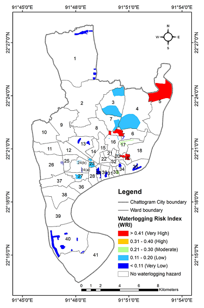
In recent years, rainfall-induced waterlogging has become a common hazard in the highly urbanized coastal city of Chattogram, Bangladesh resulting in high magnitude of property damage and economic loss. Therefore, the primary objective of this research is to prepare a waterlogging inventory map and understand the spatial variation of the risk by means of hazard intensity, exposure, and vulnerability of waterlogging. In this research, the inventory map and factors influencing waterlogging hazard were determined from a participatory survey and other spatial data including land elevation, population, and structural data were collected from secondary sources. Analytical Hierarchy Process was applied to measure the hazard intensity and the exposure and vulnerability were estimated by overlaying the spatial data onto the hazard intensity map. A total of 58 locations in 22 wards have been identified as waterlogging affected, which covers ~8.42% of the city area. Obtained waterlogging vulnerability index map suggests that ward no. 5, 6, 16, 17, and 33 are greatly vulnerable to waterlogging in terms of their social, infrastructure, critical facilities, economic and environmental vulnerability. We show that ~2.71% of the study area is at very high risk, while the risk score is considerably higher for ward no. 5, 8, 17, 19, and 33.

