Submitted:
07 February 2023
Posted:
08 February 2023
You are already at the latest version
Abstract
Keywords:
1. Introduction
2. Multi-mission/Multi-frequency SAR Dataset
2.1. Selected Scenarios
2.2. Footprint Matching
2.3. AIS Data
3. Method
3.1. Pre-processing Chains
3.2. The CFAR+SLA detector
| Parameter / Mission | Sentinel-1 | COSMO-SkyMed | SAOCOM |
|---|---|---|---|
| 102.0 Hz | 466.6 Hz | 372.0 Hz | |
| 102.0 Hz | 466.6 Hz | 372.0 Hz | |
| 7,17 | 17,17 | 3,17 |
4. Experimental Analysis
4.1. Performance Indicators
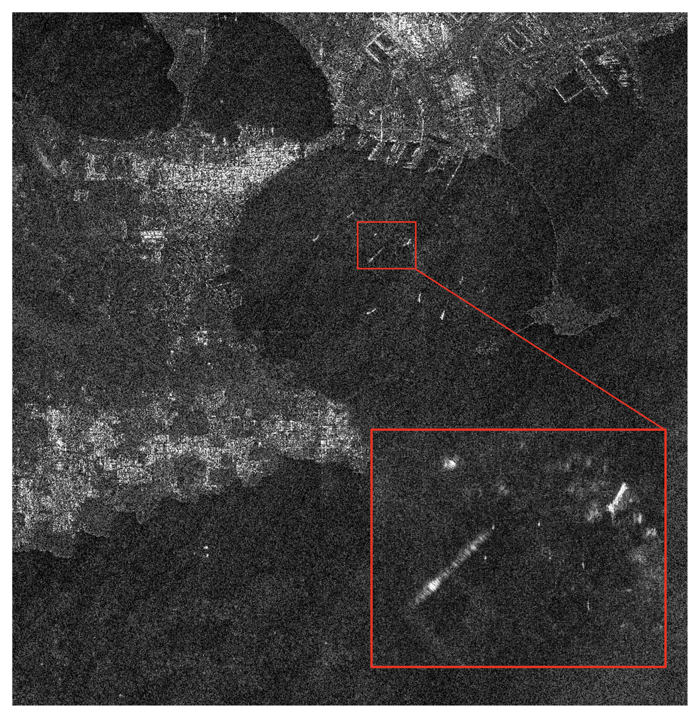
4.2. Local Analysis
4.3. Global Analysis
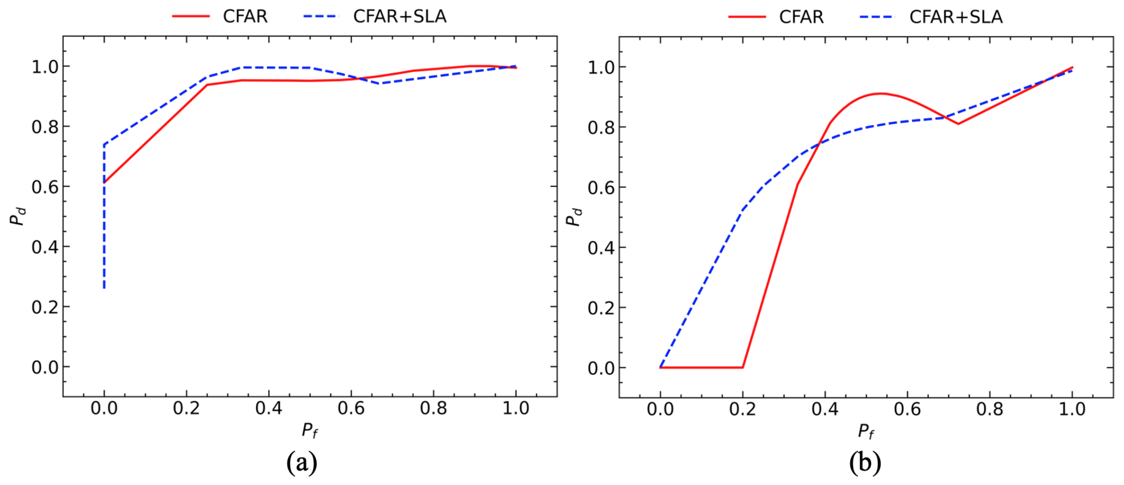
4.3.1. Egadi Islands
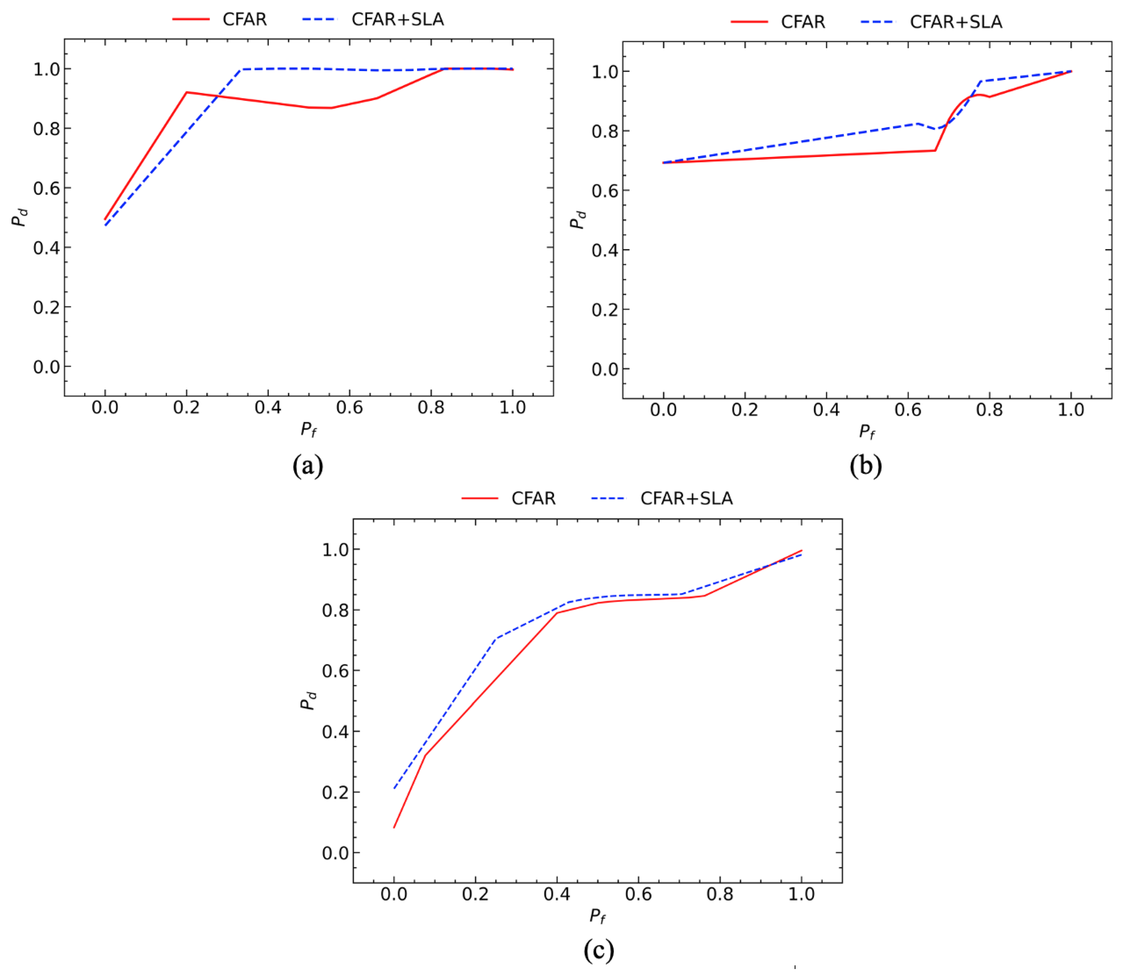
4.3.2. Sardinia
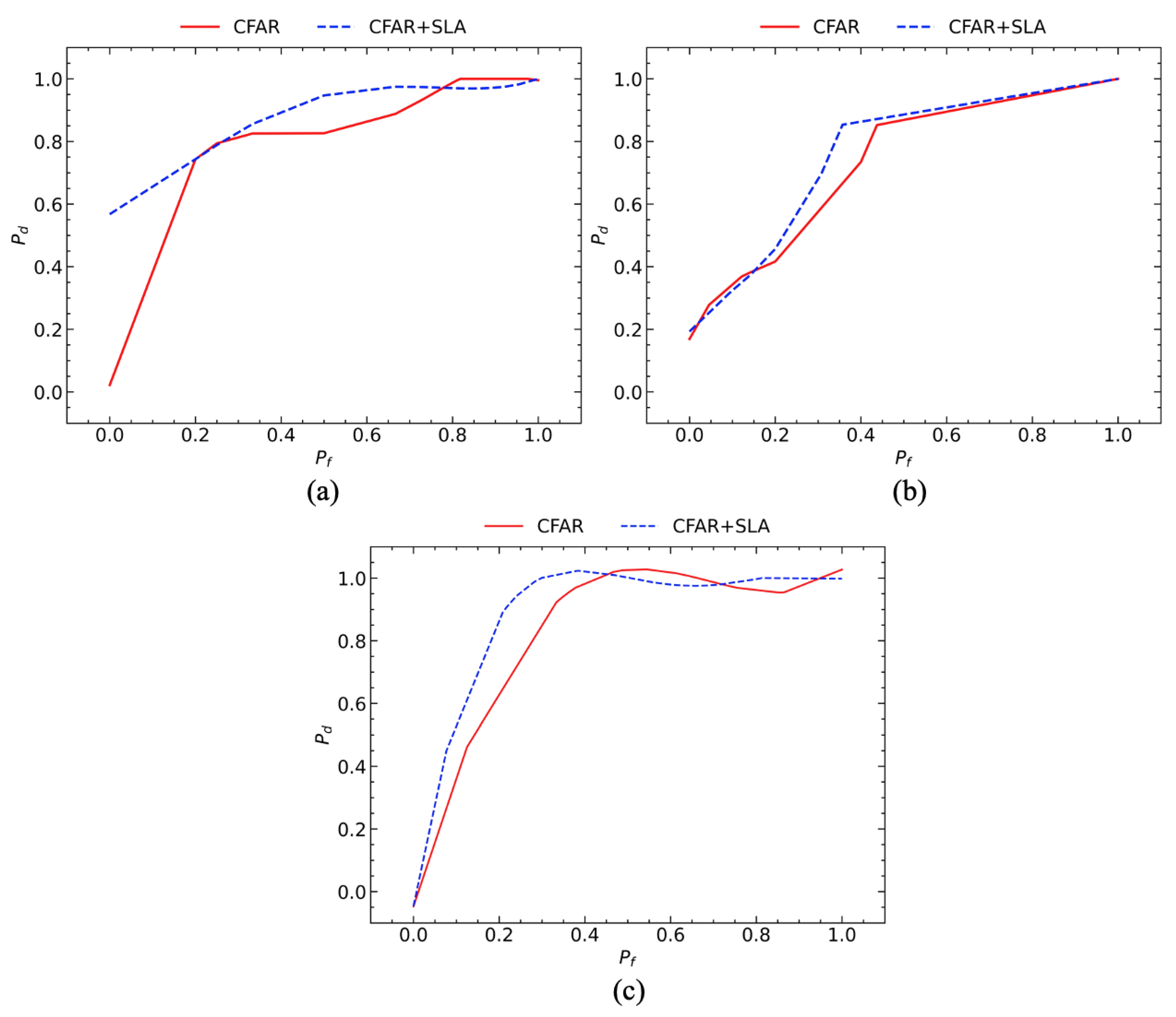
4.3.3. Adriatic Sea
4.3.4. Area Under the Curve
5. Conclusions
Funding
Acknowledgments
Conflicts of Interest
References
- Nimmich, J.L.; Goward, D.A. Maritime domain awareness: the key to maritime security. International Law Studies 2007, 83, 6. [Google Scholar]
- Balci, M.; Pegg, R. Towards Global Maritime Domain Awareness-" Recent Developments and Challenges". 2006 9th international conference on information fusion. IEEE, 2006, pp. 1–5.
- Tetreault, B. Use of the Automatic Identification System (AIS) for maritime domain awareness (MDA). Proceedings of OCEANS 2005 MTS/IEEE, 2005, pp. 1590–1594 Vol. 2. [CrossRef]
- Graziano, M.D.; D’Errico, M.; Rufino, G. Wake component detection in X-band SAR images for ship heading and velocity estimation. Remote Sensing 2016, 8, 498. [Google Scholar] [CrossRef]
- Graziano, M.D.; D’Errico, M.; Rufino, G. Ship heading and velocity analysis by wake detection in SAR images. Acta astronautica 2016, 128, 72–82. [Google Scholar] [CrossRef]
- Graziano, M.D. Preliminary results of ship detection technique by wake pattern recognition in SAR images. Remote Sensing 2020, 12, 2869. [Google Scholar] [CrossRef]
- Del Prete, R.; Graziano, M.D.; Renga, A. First results on wake detection in SAR images by deep learning. Remote Sensing 2021, 13, 4573. [Google Scholar] [CrossRef]
- Joshi, S.K.; Baumgartner, S.V. Range-Doppler tracking of ships using single-channel airborne radar data. EUSAR 2021; 13th European Conference on Synthetic Aperture Radar. VDE, 2021, pp. 1–6.
- Eldhuset, K. An automatic ship and ship wake detection system for spaceborne SAR images in coastal regions. IEEE transactions on Geoscience and Remote Sensing 1996, 34, 1010–1019. [Google Scholar] [CrossRef]
- Shao, Z.; Wu, W.; Wang, Z.; Du, W.; Li, C. Seaships: A large-scale precisely annotated dataset for ship detection. IEEE transactions on multimedia 2018, 20, 2593–2604. [Google Scholar] [CrossRef]
- Young, W. What are vessel traffic services, and what can they really do? Navigation 1994, 41, 31–56. [Google Scholar] [CrossRef]
- Goudossis, A.; Katsikas, S.K. Towards a secure automatic identification system (AIS). Journal of Marine Science and Technology 2019, 24, 410–423. [Google Scholar] [CrossRef]
- International Maritime Organization. "AIS transponders", International Maritime Organization (2017) [Online]. Available:. https://www.imo.org/en/OurWork/Safety/Pages/AIS.aspx, 2019. Accessed: 2022-12-07.
- Zhang, D.; Li, J.; Wu, Q.; Liu, X.; Chu, X.; He, W. Enhance the AIS data availability by screening and interpolation. 2017 4th International Conference on Transportation Information and Safety (ICTIS). IEEE, 2017, pp. 981–986.
- Graziano, M.D.; Renga, A.; Moccia, A. Integration of Automatic Identification System (AIS) Data and Single-Channel Synthetic Aperture Radar (SAR) Images by SAR-Based Ship Velocity Estimation for Maritime Situational Awareness. Remote Sensing 2019, 11. [Google Scholar] [CrossRef]
- Kanjir, U.; Greidanus, H.; Oštir, K. Vessel detection and classification from spaceborne optical images: A literature survey. Remote sensing of environment 2018, 207, 1–26. [Google Scholar] [CrossRef] [PubMed]
- Iceye. Dark Vessel Detection for Maritime Security with SAR Data, 2021. [Online; accessed 19. May 2021].
- Curlander, J.C.; McDonough, R.N. Synthetic aperture radar; Vol. 11, Wiley, New York, 1991.
- Pelich, R.; Longépé, N.; Mercier, G.; Hajduch, G.; Garello, R. AIS-based evaluation of target detectors and SAR sensors characteristics for maritime surveillance. IEEE Journal of Selected Topics in Applied Earth Observations and Remote Sensing 2014, 8, 3892–3901. [Google Scholar] [CrossRef]
- Wang, C.; Bi, F.; Zhang, W.; Chen, L. An intensity-space domain CFAR method for ship detection in HR SAR images. IEEE Geoscience and Remote Sensing Letters 2017, 14, 529–533. [Google Scholar] [CrossRef]
- Raney, R.K.; Princz, G.J. Reconsideration of azimuth ambiguities in SAR. IEEE Transactions on Geoscience and Remote Sensing 1987, pp. 783–787. [Google Scholar] [CrossRef]
- Guarnieri, A.M. Adaptive removal of azimuth ambiguities in SAR images. IEEE Transactions on Geoscience and Remote Sensing 2005, 43, 625–633. [Google Scholar] [CrossRef]
- Choi, J.H.; Won, J.S. Efficient SAR Azimuth Ambiguity Reduction in Coastal Waters Using a Simple Rotation Matrix: The Case Study of the Northern Coast of Jeju Island. Remote Sensing 2021, 13, 4865. [Google Scholar] [CrossRef]
- Velotto, D.; Soccorsi, M.; Lehner, S. Azimuth ambiguities removal for ship detection using full polarimetric X-band SAR data. IEEE transactions on geoscience and remote sensing 2013, 52, 76–88. [Google Scholar] [CrossRef]
- Touzi, R.; Hurley, J.; Vachon, P.W. Optimization of the degree of polarization for enhanced ship detection using polarimetric RADARSAT-2. IEEE Transactions on Geoscience and Remote Sensing 2015, 53, 5403–5424. [Google Scholar] [CrossRef]
- Touzi, R. On the use of polarimetric SAR data for ship detection. IEEE 1999 International Geoscience and Remote Sensing Symposium. IGARSS’99 (Cat. No. 99CH36293). IEEE, 1999, Vol. 2, pp. 812–814.
- Brekke, C.; Anfinsen, S.N. Ship detection in ice-infested waters based on dual-polarization SAR imagery. IEEE Geoscience and Remote Sensing Letters 2010, 8, 391–395. [Google Scholar] [CrossRef]
- Marino, A.; Sanjuan-Ferrer, M.J.; Hajnsek, I.; Ouchi, K. Ship detection with spectral analysis of synthetic aperture radar: A comparison of new and well-known algorithms. Remote Sensing 2015, 7, 5416–5439. [Google Scholar] [CrossRef]
- Wang, W.; Ji, Y.; Lin, X. A novel fusion-based ship detection method from Pol-SAR images. Sensors 2015, 15, 25072–25089. [Google Scholar] [CrossRef] [PubMed]
- Xie, Q.; Ballester-Berman, J.D.; Lopez-Sanchez, J.M.; Zhu, J.; Wang, C. Quantitative analysis of polarimetric model-based decomposition methods. Remote Sensing 2016, 8, 977. [Google Scholar] [CrossRef]
- Zhu, J.; Qiu, X.; Pan, Z.; Zhang, Y.; Lei, B. Projection shape template-based ship target recognition in TerraSAR-X images. IEEE Geoscience and Remote Sensing Letters 2016, 14, 222–226. [Google Scholar] [CrossRef]
- Wang, C.; Bi, F.; Chen, L.; Chen, J. A novel threshold template algorithm for ship detection in high-resolution SAR images. 2016 IEEE International Geoscience and Remote Sensing Symposium (IGARSS). IEEE, 2016, pp. 100–103.
- Song, S.; Xu, B.; Yang, J. SAR target recognition via supervised discriminative dictionary learning and sparse representation of the SAR-HOG feature. Remote Sensing 2016, 8, 683. [Google Scholar] [CrossRef]
- Zhou, D.; Zeng, L.; Zhang, K. A novel SAR target detection algorithm via multi-scale SIFT features. J. Northwest. Polytech. Univ 2015, 33, 867–873. [Google Scholar]
- Ai, J.; Tian, R.; Luo, Q.; Jin, J.; Tang, B. Multi-scale rotation-invariant Haar-like feature integrated CNN-based ship detection algorithm of multiple-target environment in SAR imagery. IEEE Transactions on Geoscience and Remote Sensing 2019, 57, 10070–10087. [Google Scholar] [CrossRef]
- Zhang, T.; Zhang, X. High-speed ship detection in SAR images based on a grid convolutional neural network. Remote Sensing 2019, 11, 1206. [Google Scholar] [CrossRef]
- Chen, C.; He, C.; Hu, C.; Pei, H.; Jiao, L. A deep neural network based on an attention mechanism for SAR ship detection in multiscale and complex scenarios. IEEE Access 2019, 7, 104848–104863. [Google Scholar] [CrossRef]
- Zhang, T.; Zhang, X.; Shi, J.; Wei, S. Depthwise separable convolution neural network for high-speed SAR ship detection. Remote Sensing 2019, 11, 2483. [Google Scholar] [CrossRef]
- Wang, Y.; Wang, C.; Zhang, H.; Dong, Y.; Wei, S. A SAR dataset of ship detection for deep learning under complex backgrounds. remote sensing 2019, 11, 765. [Google Scholar] [CrossRef]
- Chang, Y.L.; Anagaw, A.; Chang, L.; Wang, Y.C.; Hsiao, C.Y.; Lee, W.H. Ship detection based on YOLOv2 for SAR imagery. Remote Sensing 2019, 11, 786. [Google Scholar] [CrossRef]
- Jiao, J.; Zhang, Y.; Sun, H.; Yang, X.; Gao, X.; Hong, W.; Fu, K.; Sun, X. A densely connected end-to-end neural network for multiscale and multiscene SAR ship detection. IEEE Access 2018, 6, 20881–20892. [Google Scholar] [CrossRef]
- Li, J.; Qu, C.; Shao, J. Ship detection in SAR images based on an improved faster R-CNN. 2017 SAR in Big Data Era: Models, Methods and Applications (BIGSARDATA). IEEE, 2017, pp. 1–6.
- Wei, S.; Zeng, X.; Qu, Q.; Wang, M.; Su, H.; Shi, J. HRSID: A high-resolution SAR images dataset for ship detection and instance segmentation. Ieee Access 2020, 8, 120234–120254. [Google Scholar] [CrossRef]
- Wackerman, C.C.; Friedman, K.S.; Pichel, W.G.; Clemente-Colón, P.; Li, X. Automatic detection of ships in RADARSAT-1 SAR imagery. Canadian journal of remote sensing 2001, 27, 568–577. [Google Scholar] [CrossRef]
- Friedman, K.; Wackerman, C.; Funk, F.; Rowell, K.; Pichel, W.; Clemente-Colón, P.; Li, X. Validation of an automatic vessel detection algorithm using SAR data and known vessel fleet distributions. IGARSS 2000. IEEE 2000 International Geoscience and Remote Sensing Symposium. Taking the Pulse of the Planet: The Role of Remote Sensing in Managing the Environment. Proceedings (Cat. No. 00CH37120). IEEE, 2000, Vol. 5, pp. 2071–2073.
- Friedman, K.S.; Wackerman, C.; Funk, F.; Schwenzfeier, M.; Pichel, W.G.; Colon-Clemente, P.; Li, X. Analyzing the dependence between RADARSAT-1 vessel detection and vessel heading using CFAR algorithm for use on fishery management. Oceans 2003. Celebrating the Past... Teaming Toward the Future (IEEE Cat. No. 03CH37492). IEEE, 2003, Vol. 5, pp. P2819–P2823.
- Friedman, K.S.; Wackerman, C.; Funk, F.; Pichel, W.G.; Clemente-Colón, P.; Li, X. Validation of a CFAR vessel detection algorithm using known vessel locations. IGARSS 2001. Scanning the Present and Resolving the Future. Proceedings. IEEE 2001 International Geoscience and Remote Sensing Symposium (Cat. No. 01CH37217). IEEE, 2001, Vol. 4, pp. 1804–1806.
- Renga, A.; Graziano, M.D.; Moccia, A. Segmentation of marine SAR images by sublook analysis and application to sea traffic monitoring. IEEE Transactions on Geoscience and Remote Sensing 2018, 57, 1463–1477. [Google Scholar] [CrossRef]
- Biffia, A.; Dodaro, L.; Morabito, F.; Pergolizzi, A. Mare Monstrum. https://www.legambiente.it/wp-content/uploads/Dossier-Mare-Monstrum-2019.pdf, 2020. Accessed: 2022-12-13.
- Biffia, A.; Dodaro, L.; Morabito, F.; Pergolizzi, A. Mare Monstrum. https://www.legambiente.it/wp-content/uploads/2020/06/MareMonstrum2020.pdf, 2019. Accessed: 2022-12-13.
- Furesi, R.; Madau, F.; Pulina, P.; Sai, R.; Pinna, M.; Pais, A. Profitability and sustainability of edible sea urchin fishery in Sardinia (Italy). Journal of coastal conservation 2016, 20, 299–306. [Google Scholar] [CrossRef]
- Spera, G.; Monaco, P. RAPPORTO ANNUALE SUL CONTROLLO DELLA PESCA IN ITALIA. https://www.guardiacostiera.gov.it/stampa/Documents/RAPPORTO%20ANNUALE%202020%20-%20DOWNLOAD.pdf, 2019. Accessed: 2022-12-13.
- Graziano, M.D.; Prete, R.D.; Grasso, M. A NEW DATASET OF MULTI-MISSION/MULTI-FREQUENCY SAR DATA FOR MARITIME MONITORING: FIRST RESULTS AND CRITICAL ANALYSIS. 2022.
- Miler, R.K. The Exactearth Satelite-AIS Benefits for the Maritime Transport. Prace Naukowe Wyższej Szkoły Bankowej w Gdańsku 2013, 28, 71–86. [Google Scholar]
- Dellepiane, S.; De Laurentiis, R.; Giordano, F. Coastline extraction from SAR images and a method for the evaluation of the coastline precision. Pattern Recognition Letters 2004, 25, 1461–1470, Pattern Recognition for Remote Sensing (PRRS 2002). [Google Scholar] [CrossRef]
- Open Street Map. "Data Derived from OpenStreetMap for Download", Open Street Map [Online]. Available:. https://osmdata.openstreetmap.de/data/land-polygons.html, 2022. Accessed: 2022-12-07.
- Benachenhou, K.; Taleb-Ahmed, A.; Hamadouche, M. Performances evaluation of GNSS ALTBOC acquisition with CFAR detection in Rayleigh fading channel. 2013 Saudi International Electronics, Communications and Photonics Conference. IEEE, 2013, pp. 1–7.
- Guida, M.; Longo, M.; Lops, M. Biparametric CFAR procedures for lognormal clutter. IEEE Transactions on Aerospace and Electronic Systems 1993, 29, 798–809. [Google Scholar] [CrossRef]
- Anastassopoulos, V.; Lampropoulos, G.A. Optimal CFAR detection in Weibull clutter. IEEE Transactions on Aerospace and Electronic systems 1995, 31, 52–64. [Google Scholar] [CrossRef]
- Erfanian, S.; Vakili, V.T. Introducing excision switching-CFAR in K distributed sea clutter. Signal Processing 2009, 89, 1023–1031. [Google Scholar] [CrossRef]
- Leng, X.; Ji, K.; Yang, K.; Zou, H. A Bilateral CFAR Algorithm for Ship Detection in SAR Images. IEEE Geoscience and Remote Sensing Letters 2015, 12, 1536–1540. [Google Scholar] [CrossRef]
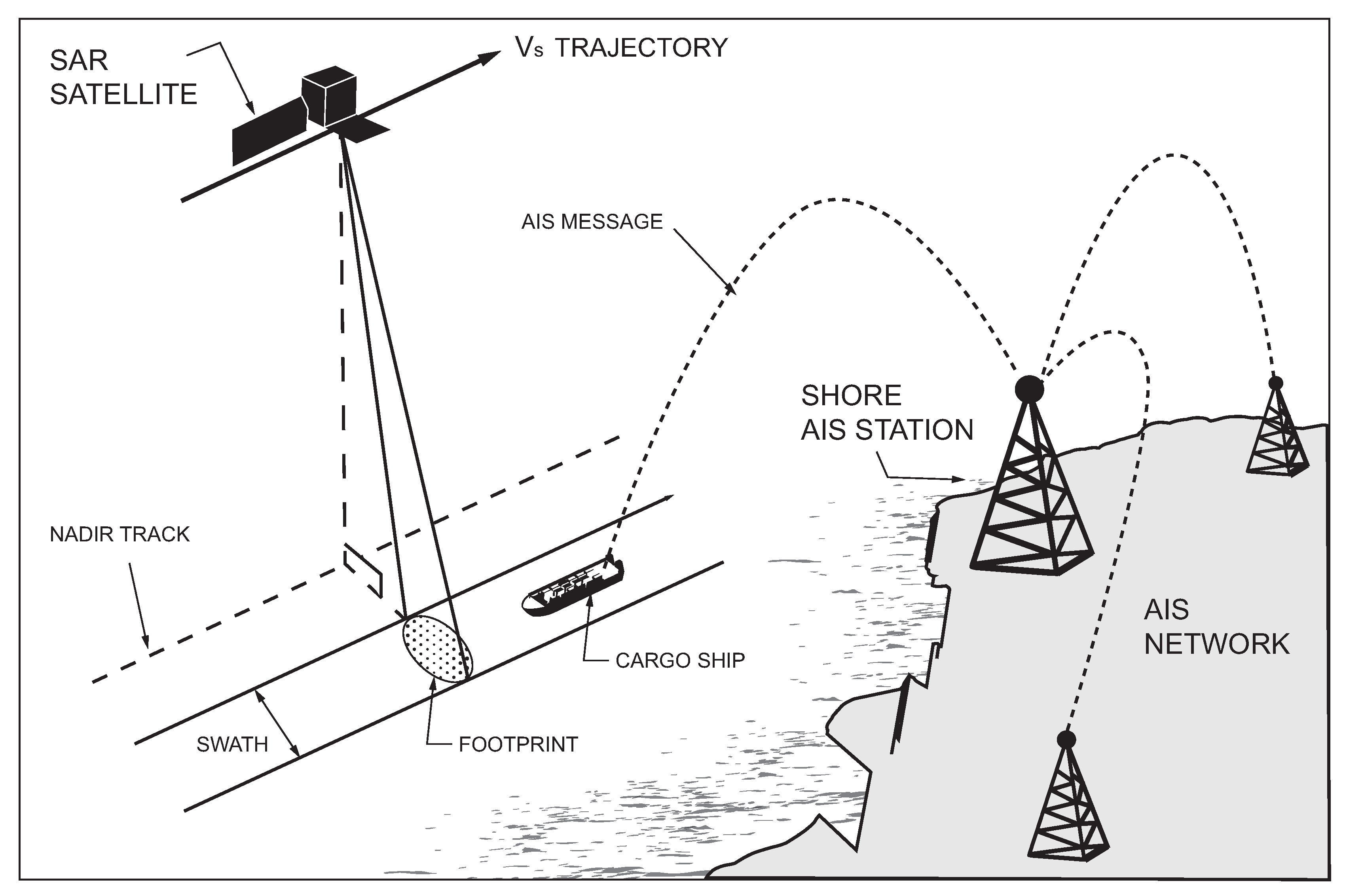
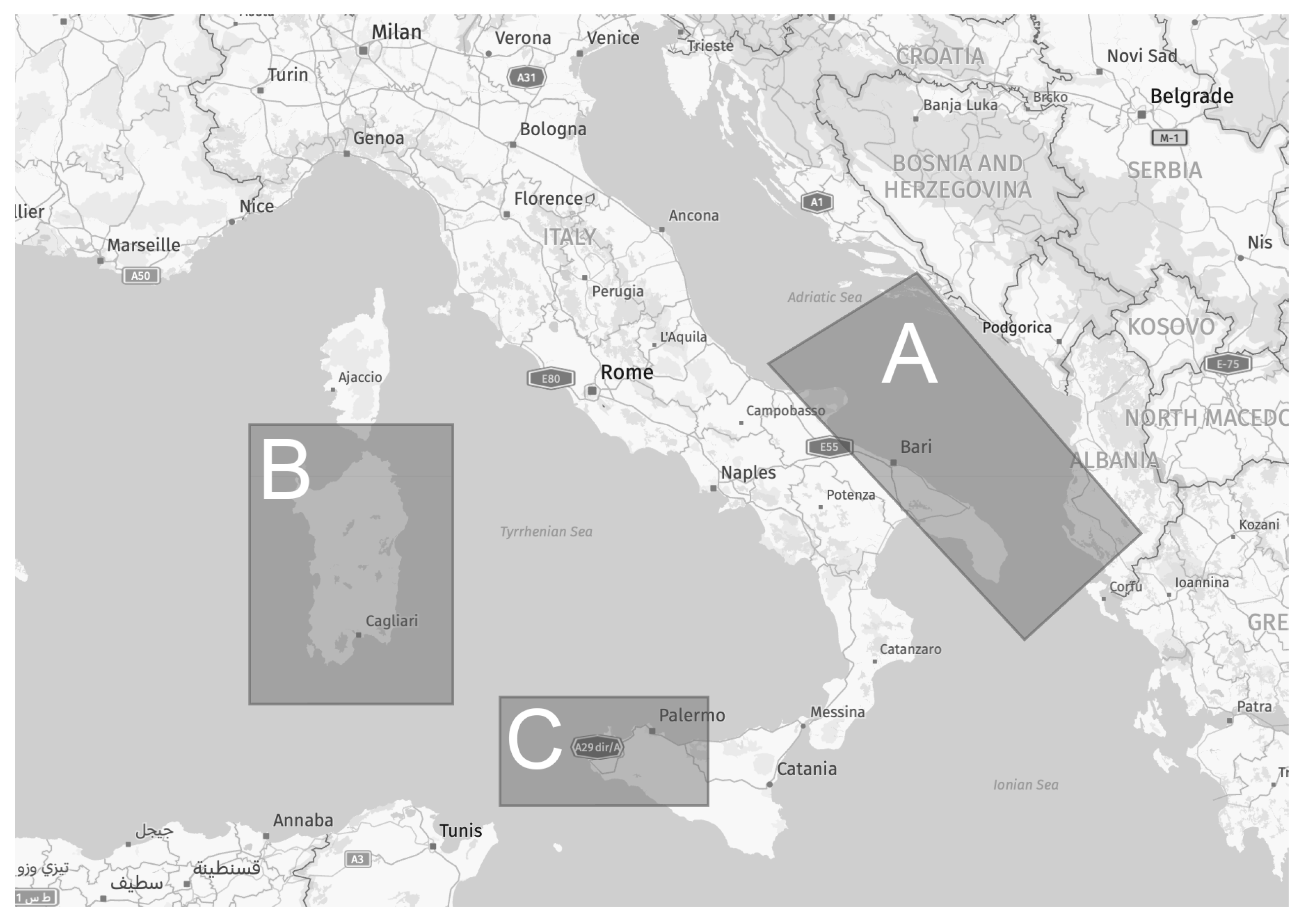
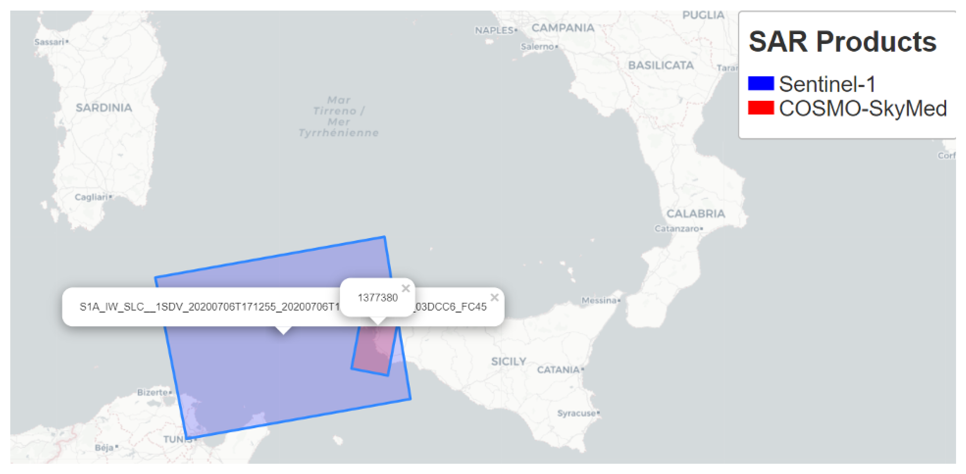

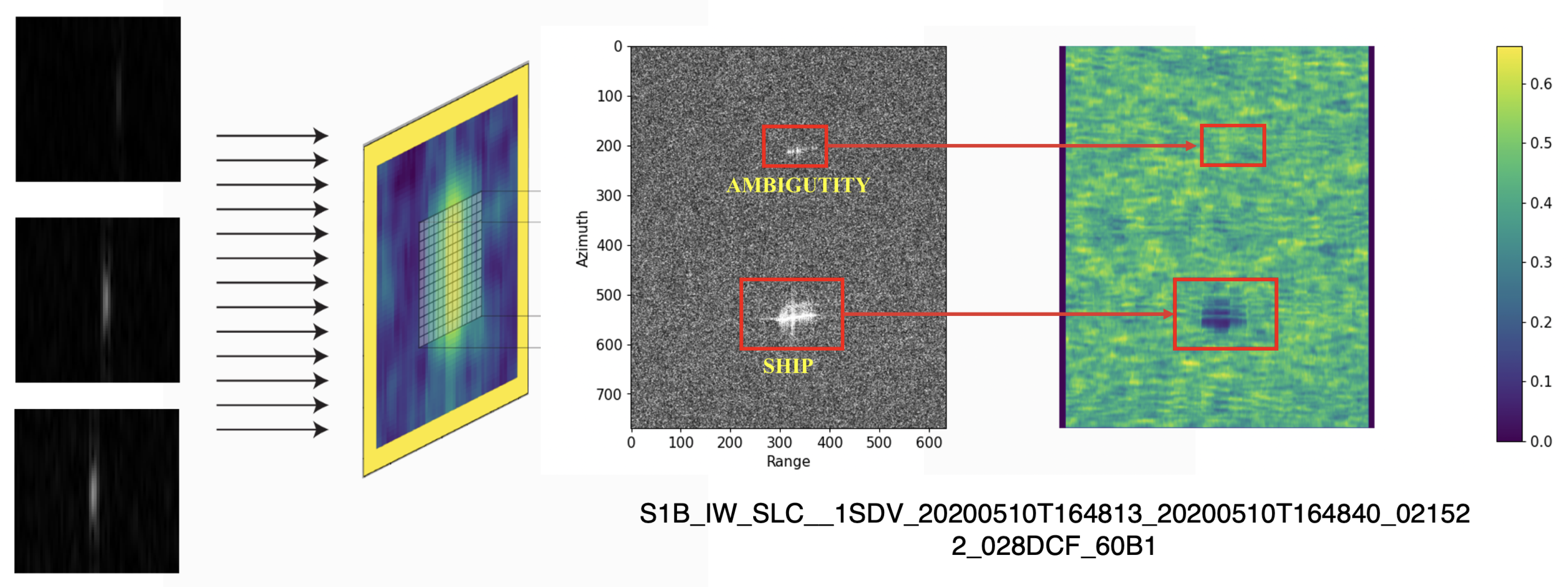


| Mission | Acquisition Mode | Resolution (range x azi) (m) | Pixel spacing (range x azi) (m) | Polarization | Swath (km) |
|---|---|---|---|---|---|
| COSMO-SkyMed | StripMap | 3 x 3 | 2.35 × 4.14 | HH | 40 |
| Sentinel-1 | IW (Interferometric Wide Swath) | 20 x 5 | 2.3 x 13.9 | VH | 250 |
| SAOCOM | StripMap | 10 x 10 | 10 x 10 | VH | 65 |
| Region / Pairing | Adriatic Sea | Egadi Islands | Sardinia |
|---|---|---|---|
| COSMO-SkyMed & Sentinel-1 | 15 | 32 | 55 |
| COSMO-SkyMed & SAOCOM | 5 | NA | 23 |
| Sentinel-1 & SAOCOM | 12 | NA | 10 |
| Operator / Product | COSMO-SkyMed | SAOCOM | Sentinel-1 |
|---|---|---|---|
| Multilook | ✓ | ||
| Thermal noise removal | ✓ | ||
| TOPSAR Deburst | ✓ | ✓ | |
| Land-Masking | ✓ | ✓ | ✓ |
| Calibration | ✓ |
| BW | GW | TW | PFA ( ) | Min Target Size | Max Target Size |
|---|---|---|---|---|---|
| 800 m | 400 m | 30 m | 4.5 | 30 m | 800 m |
| Accuracy | CFAR | CFAR+SLA | |||||
|---|---|---|---|---|---|---|---|
| Vessels | 92.3% | ||||||
| Ambiguities | 100% | ||||||
| Global | 95.6% | 100% | 47.8% | 100% | 7.6% | ||
Disclaimer/Publisher’s Note: The statements, opinions and data contained in all publications are solely those of the individual author(s) and contributor(s) and not of MDPI and/or the editor(s). MDPI and/or the editor(s) disclaim responsibility for any injury to people or property resulting from any ideas, methods, instructions or products referred to in the content. |
© 2023 by the authors. Licensee MDPI, Basel, Switzerland. This article is an open access article distributed under the terms and conditions of the Creative Commons Attribution (CC BY) license (http://creativecommons.org/licenses/by/4.0/).


