1. Introduction
Since the Reformation era took place and Regional Autonomous Law established in the Mid-1980s in Indonesia, there were eleven new provinces established until 2022 making a total 37 provinces (1), and a total of 514 Districts/Municipalities (2). The establishment of new provinces and districts/municipalities have brought wide consequences to the infrastructures development, changes in land use/land covers and property rights (3), expansion of urban landscapes and transition in farming (4,5).
The Government of Indonesia (GoI) aware to protect agricultural land, particularly conversion of rice land areas to non-agricultural purposes (6). Two important legislation related to the land were Act No. 26/2006 regarding Spatial Plan Regulation (SPR) that operationalized by Government Regulation No. 21/2021 and Act No. 41/2009 regarding Protection of Sustainable Agricultural Land. Both Acts should be followed-up Provincial and Districts Regulations in accordance with the Regional Administration Law No. 32/2004.
Rice land is considered as the most critical areas to be protected since it most contributed to the food security, particularly for rice self-sufficient. Nevertheless, conversion of rice land is still going-on and reported it was in the alarming level. (7). Agus and Irawan (2) reported that land conversion rate for irrigated land during 1999 – 2022 was 141,000 ha/year. Firman (3) estimated that during 1991 – 1993 there was around 106,000 ha agricultural land converted for urban land and mostly for residential areas. The studied of Mulyani et al. (4) showed that with the present conversion rate of 96,512 ha/year during 2000 – 2015, they predicted that the current of 8.1 million ha of paddy field will be decreased to 5.1 million ha in 2045 if there is no government intervention to slowdown or control it. This will have serious impact on rice self-sufficient program.
The main reason leading to this rapid change is due to development planning that bias to economic growth and infrastructure, while less taken into consideration in maintaining agricultural land, particularly fertile rice lands (11,12). Fast conversion of agricultural land created agricultural land ownership decreased to only 0.89 ha/household in 2013 or even less than 0.5 ha particularly in Java (13). In East Nusa Tenggara (ENT) province, agricultural land decreased 11,162 ha by comparing data 2007 – 2022 and 2013-2017 (14). The small land ownership of rice farm make the use of rice farming inputs were less efficient and to rice production is less competitive to other crops (15), and rice farming is no longer attractive for young generations (16,17), expansion or increasing the size of rice land is crucial to increase rice production and make rice farming more attractive as Rosyda et al. (10) in their research in Java Island come into one conclusion that “land and intermediate inputs were the factor inputs that significantly increased technical efficiency”.
This research is based on the case study in the Central Sumba as a lens to understand conversion of agricultural land, how do government policy on land management in devolution era works, and its implication to the food security or rice self-sufficient. As the Central Sumba District is a new District – expanded from West Sumba District, the paper is also looking the implication of new district and new town development in mostly agricultural land which was quite different from newly expanded District. The working hypothesis of this research was that creation of new district/town during the decentralization era has considerable impacts to the land cover and food security for the people living in dominant semi-arid environment. The research employs a survey method in understanding the rate of land conversion, while spasial data on land uses to understand land cover changes.
2. Materials and Methods
2.1. Description of Study Area
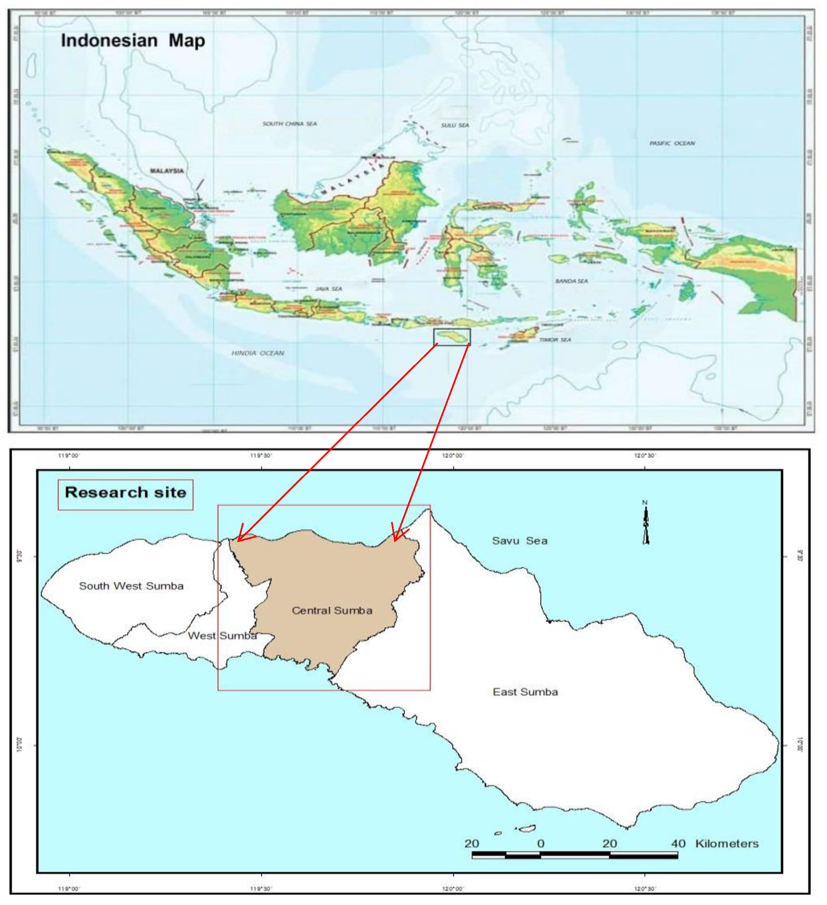
The Central Sumba District of East Nusa Tenggara (ENT) province of Indonesia (
Figure 1) is located in the central of Sumba island that astronomically situated between 9
0 20’ - 9
0 50’ South Latitude dan 119
0 22’ - 119
0 55’ East Longitude (43). The study site was chosen purposively as a new established District and one the district where Food Estate (FE) Program carried out in ENT province.
Physical characteristics of the district is characterized the savannah environment, however within this district located the remnant of dry-forest area of Tana Daru Protected Forest in Central Sumba as part of the Taman Nasional Manupeu Tanah Daru ( TNMTD) or Manupeu Tana Daru National Park which based on the Forest Ministry regulation No. 576/Kpts-II/1998, it covers an area of 87.984 ha (45) and then revised become 50,000 ha based on the Forest Ministry regulation No. 3911/Menhut-VII/KUH/2014 (46). The TNMTD represents the semi-evergreen forests and the protection and conservation of it is valued to protect endemic or near endemic species of some flora and fauna, water resources, and improving the welfare of local communities living around the national park (47,48).
Central Sumba district have several zone agro-ecosystems as a direct impact of physical and climatic variations of the region, from the rocky and savannah dry climate in the Northern region, dominated alluvial soils and relatively wet climate in the mid-region and dry climate in the Southern region. People scattered following access to the natural resources, particularly water and agricultural lands. Therefore, most people concentrated in the midland and along small creeks.
2.2. The Study and Respondents
The study was conducted in 6 Sub-districts of Central Sumba District, East Nusa Tenggara (ENT) Province - Indonesia. The Data come from 3 consecutive inter-related research studies such as: 1). Impact of Socio-cultural and Economic of Food Estate Program to People's Welfare, conducted in 2021 and involved 48 respondents (49); 2). Rice farms ownership patterns, conducted in 2022 and involved 259 respondents (50); and 3) The Study to provide document of “Sustainable Food Crops Lands,” conducted in 2022 and involved 564 respondents (51).
2.3. Materials and Research Methods
Survey method employed for primary data collection by conducting Focus Group Discussions (FGD) with government apparatus, village chair, key informants, farmers groups, and agriculture extension workers. After the FGD, it followed with in-depth interviews with some respondents involved in the FGD meeting. The remaining primary data collected using questionnaire of google form application.
2.4. Data Analysis
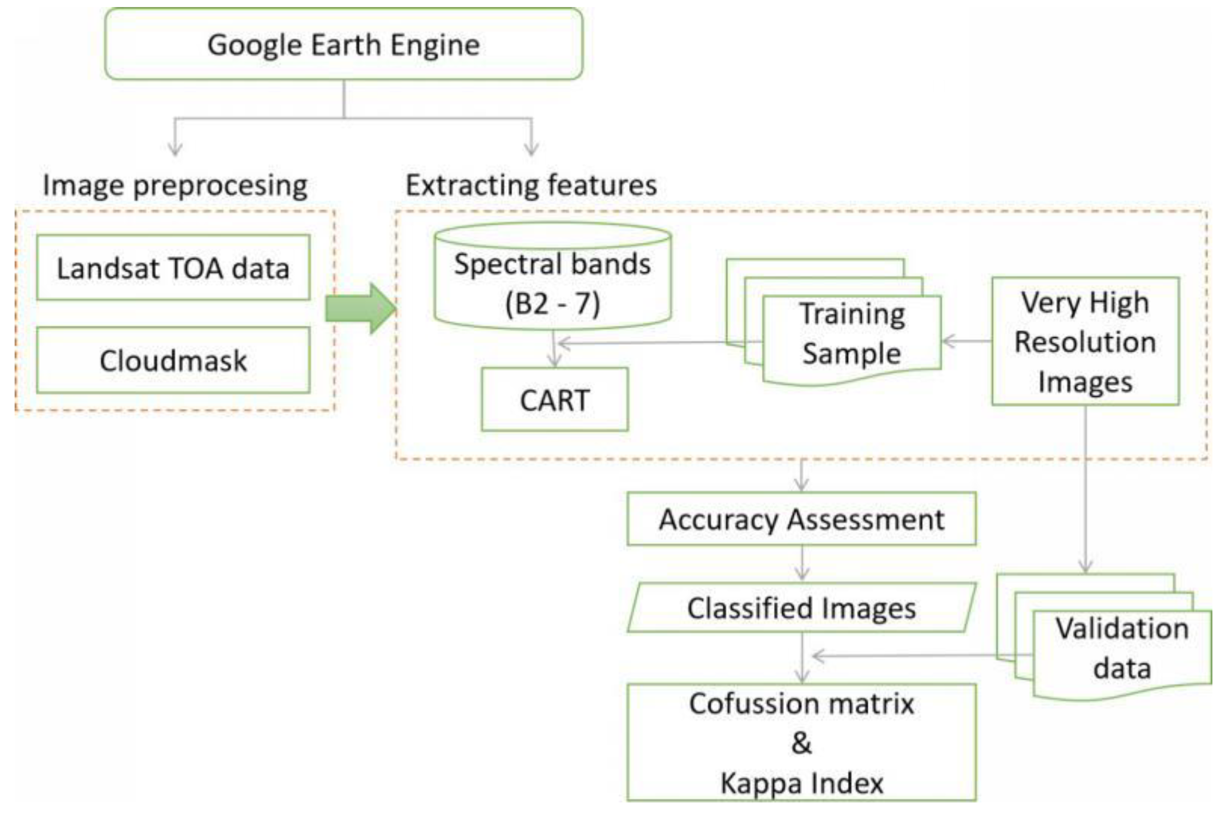
Classification and regression tree (CART) for land cover classification has been analyzed using machine learning techniques using Google Earth Engine. The Platform for processing using remote sensing data is Landsat 8 for interpretation in understanding the method here, the image shown processing step.
Figure 1.
processing step to get Land use Land Cover and accuracy check.
Figure 1.
processing step to get Land use Land Cover and accuracy check.
The selection of the Landsat data used must eliminate some noise in the data, such as the influence of clouds and sunlight reflections. In this case, the Landsat 8 data uses TOA corrected data and cloud masked data using mosaicking data. Topographic correction is an important step in processing remote sensing data that takes into account the varying elevation of the terrain. The shadow effect from hills and mountains can cause errors in the data, which can affect the accuracy of the analysis. The Illumination Condition and Rotation model algorithm is a widely used method for topographic correction. This method uses the sun angle and the slope of the terrain to adjust the reflectance values of the pixels in the image, so that they are more accurate and comparable across different terrain elevations (52). Clouds can affect the accuracy of remote sensing data, so it is important to detect and mask them. Three algorithms are used to ensure that all clouds are detected: Multi temporal cloud Masking (MCM) (53), New Automated cloud cover detection (54), and Sentinel data standard cloud detection algorithm- 2 (55,56).
Composite annual data to combine single recording data that has been corrected for topography and cloud masking into annual data so that no data is empty because of clouds, the composite algorithm is carried out by taking the median value of the temporal pixels of the rice fields (54,57).
Landsat imagery has been examined to get 4 classes (paddy field, forest, upland agriculture, and urban). To get a classified map of land cover in an area of interest, training points for manually identifying have been created based on high-resolution data, such as Google Earth Map and SPOT 6/7. Those training points have been used to train a classifier. The classifier used CART to classify the rest of the Landsat image into those four categories. The landcover categories as the class property to categorize the imagery into, and the reflectance in B2 - B7 of the Landsat imagery as the input Properties. The accuracy of the classification has been assessed using Classifier Confusion Matrix and kappa index (58–64). Image data for 2013 and 2021 are classified using the same training sample. A training sample is made using 2021 data, then a machine learning model is used to classify data for 2013 and 2021. This is done because the initial processing used for both data is the same, and to produce consistent classification results.
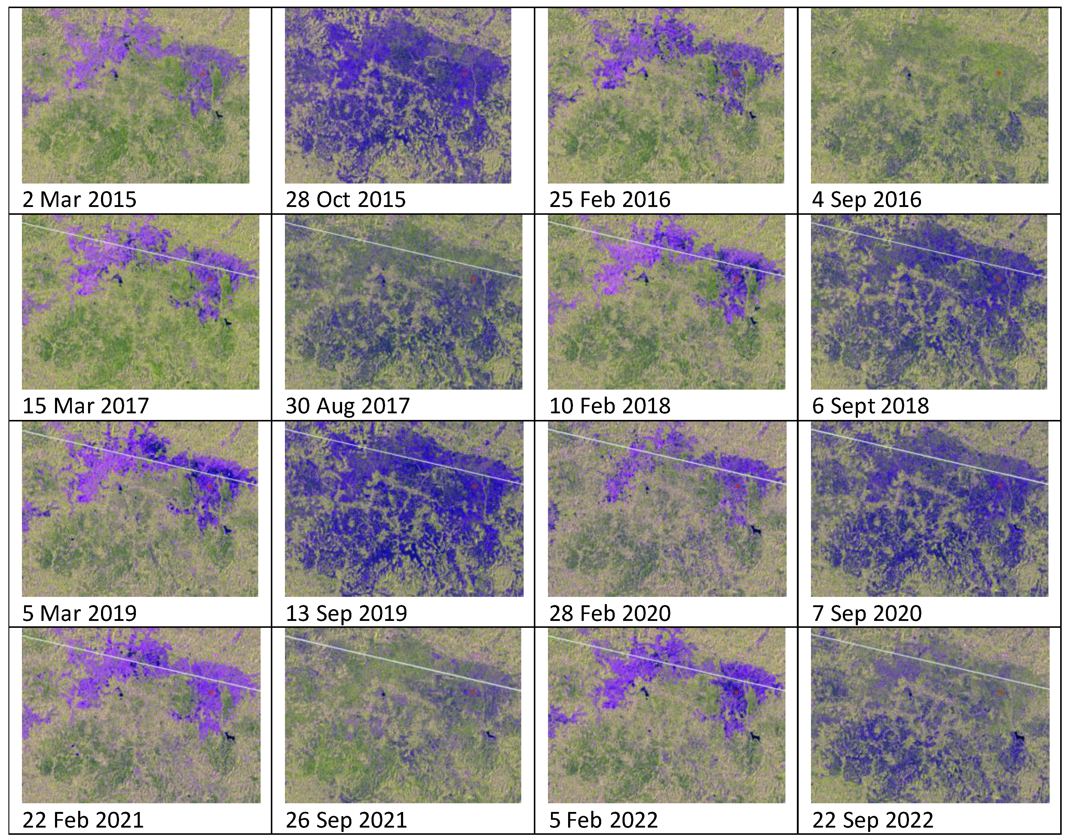
Due to the incomplete availability of Landsat data from clouds every year, apart from Landsat 8, Sentinel-1 is also used to obtain information on planting frequency, every 12 days. For the cropping frequency, Sentinel-1 SAR Imagery is used on a single recording (not composite), with RGB composition using bands VV, VH, VV/VH respectively. Image acquisition was taken at planting time, in the first growing season and the second growing season. The goal is to see the growth phase. Using Sentinel-1 toolbox from ESA (European Space Agency) in Google Earth Engine (GEE) ()_ with some processing such as: using Orbit files, remove thermal noise, remove GRD border noise, radiometric calibration, and range- Doppler terrain correction (65).
The data was analyzed by statistics descriptively descriptively and non-parametric test. Respondents were divided into two categories: from town/suburb and rural areas. Descriptive analyses employed to analyses economic status of the rice land (both irrigated and rain-fed lowland); while for farmers’ attitude or perspectives regarding the variables (a) change in land size, (b) changes in main function, (c) attitude to keep its main function, (d) attitude to transfer the ownership, and (e) protecting the Land through legislation were used a Non-Parametric Mann Whitney 2-tails test (66).
3. Overview of Decentralization/Regional Autonomy (RA) and Pressure to the Agricultural Land
Regional autonomy implemented based on the Indonesia Act No. 22/1999 is actually given more power to the Local Government (Provincial and Districts) in governing their jurisdiction territory, except in National defence and security, Foreign policy, Fiscal and Monetary, Law and Religion matters. Thus Act principally is an antithesis for the previous New Order government which was a centralized and autocratic regime.
Based on the RA Act, governments in Provincial and District levels have created numerous regulations to facilitate and attract more business activities, particularly to boost Regional Income (Pendapatan Asli Daerah or PAD). Regional income by taxing should follow the Indonesia Law Number 28/2009 regarding local Taxation and Charging (19). RA normatively would bring efficiency, transparency and accountability in governing people and attract business, unfortunately, numerous studies showed that those local regulations are counterproductive to some aspects, including for the agricultural sector and environment (20–22), particularly in forestry sector (23,24).
In terms of regional agricultural development, RA Act 28 had limited the roles of the central government (Ministry of Agriculture) in relation to the Regulations, Policies and national programs which were supported by the National budget to sustain National Long-Term development (25), while the majority of the agricultural development functions was handed over to the Regional governments. Unfortunately, less support from Local Government (LG) in budgeting policy, weak coordination and communication among stakeholders have contributed to the low performance of the agricultural sector in general (26,27), while government-sponsored research have little impact for the improvement (28).
The idea of decentralization/RA is actually to improve well-being of rural dwellers through closer and better services, giving more power to the local people to manage natural resources, and enhancing people participation. Despite improvement of public services during decentralization era (29), there was a weak correlation between decentralization and poverty reduction or improvement of well-being of people in rural areas (30), and local government fails to promote local economic growth in their jurisdictions (31), especially in marginal regions (32).
Decentralization and the decision-making process are more democratic, but it also enhances fragmentations and conflicts among different parties, including in natural resources management, especially in agricultural land (33). Agrarian conflicts related to land entitlements and recognition the status of communal land or customary land ownership have lessen the capacity of local people/farmers for agricultural intensification (34,35) and triggers unfriendly land management in crop and livestock production (36–39).
In their study on transformation of agricultural land use in southeast Asia, Appelt et al. (40) showed that most reviewed cases have positive outcomes for income and employment, mixed outcomes on health and it have negative outcomes on food security, gender equality, and economic equality. Transformation of land use in Southeast Asia fostered deforestation and created substantial negative consequences on ecology (41). Rapid urbanization in South/Southeast Asia contributed the to the decreasing agricultural land and rapid deforestation (42).
4. Results
4.1. The Socio-Economic Characteristics of Central Sumba District and Respondents Description
Central Sumba district was established as a new autonomous district in 2007 based on the Government Regulation No. 2/2007. Before 2007, Central Sumba District was part of West Sumba District. Total land area of Central Sumba District was 2061 km2 and divided into 6 Sub-districts and 65 Villages (43).
Total population in 2021 was 87.260 and around 34.27% of population is considered as poor people based on the poverty line of Rp.311,199 capita-1month-1. Total number of labour force were 34,659 people or around 69 % of total working age population (43). Majority of the households working in agricultural sector and rice is the main staple. Agriculture sector contributed around 39% of district’ Gross Regional Domestic Product (GRDP).
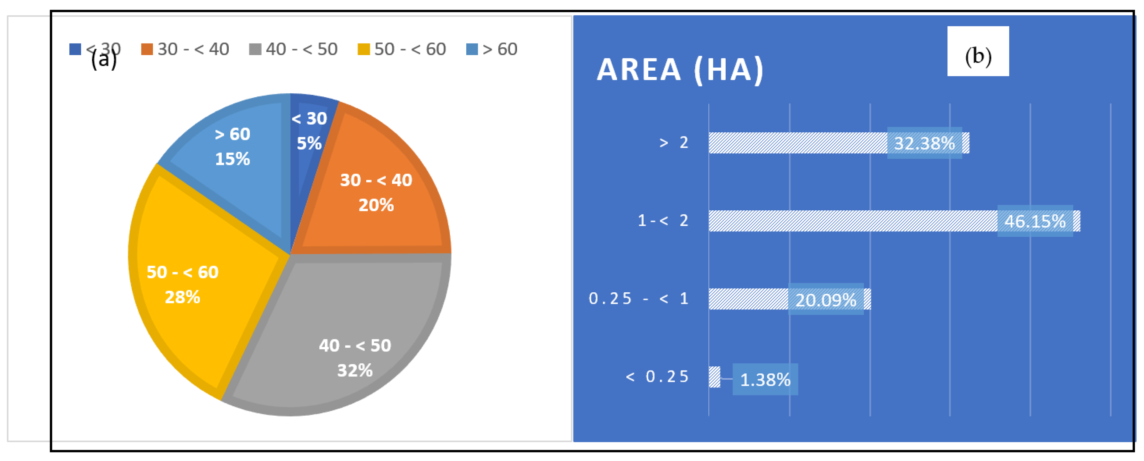
Based on the 871 respondents date taken from the 3 studied in Central Sumba District, majority of respondents were between the ages 40 - < 50 years old (32%), and then followed with older ages. Younger ages of < 30 years old were quite low (5%). This figure showed and support the general view that younger generations are not interested working in the agricultural or farming sector, and therefore old generation (> 60 years old) were still working in the farming sector.
Figure 2.
Farmers distribution based on the ages (a) and land tenure (b) (n= 871).
Figure 2.
Farmers distribution based on the ages (a) and land tenure (b) (n= 871).
Agricultural land refers to irrigated rice land, rain-fed lowland rice and upland farming for mixed food crops. Most respondents own land 1 - 2 ha or average 1.5 ha (
Figure 2b). The analysis for rice paddy farming showed that the increases of land size has significantly increases rice production (t<.000), which every increases of one ha of land size will increases 1.9 tons rice paddy.
4.2. Land Use and Land Cover Change: Current and Future Potential
4.2.1. Current land cover condition
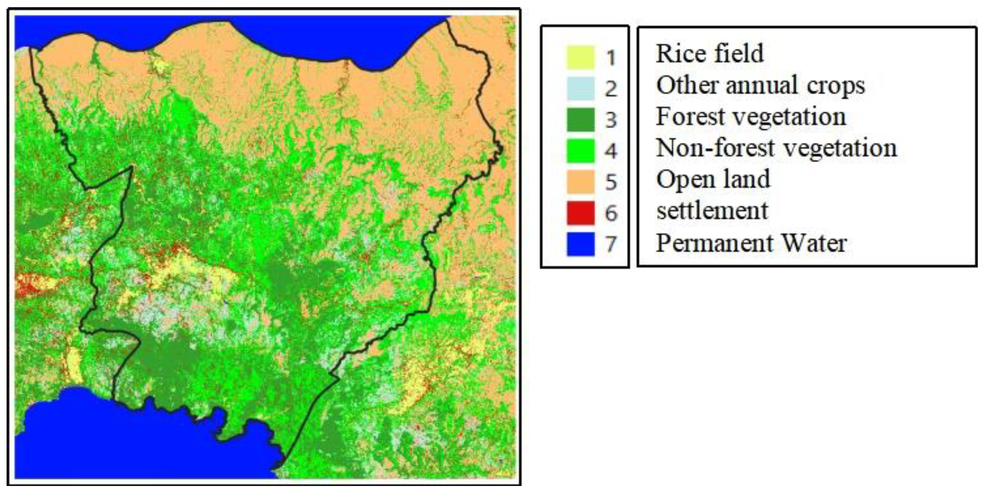
Central Sumba District is one of four districts on Sumba Island and is part of the East Nusa Tenggara Province (EAT), Indonesia. This district was formed in 2006 which is a division area of the West Sumba district, so it is now 16 years old (67). Climatologically, Central Sumba District is classified as a dry area because the amount of annual rainfall is relatively low, less than 1500 mm, and is concentrated in the four wet months during December to March. The characteristics of this dry area are that the local type of agriculture is dry land farming, where most of the people rely on this sector as their economic base. An overview of land cover, especially paddy fields, other annual crops, forest vegetation, non-forest vegetation, open Land and settlements, in this district, is shown in
Figure 3.
Figure 2 shows that Open Land in the form of savanna dominates land cover in the northern and eastern regions. This Land is hardly used as an economic resource because according to the local community, they do not have the ability to exploit this land resource for economic value. Furthermore, the dominance of the second land cover is non-forest vegetation where there is mixed vegetation with shrubs that do not cover tightly and tend to spread from the central region to the south. Meanwhile, forests are found in the central to southern regions and tend to be concentrated at three main points in the central and southern regions.
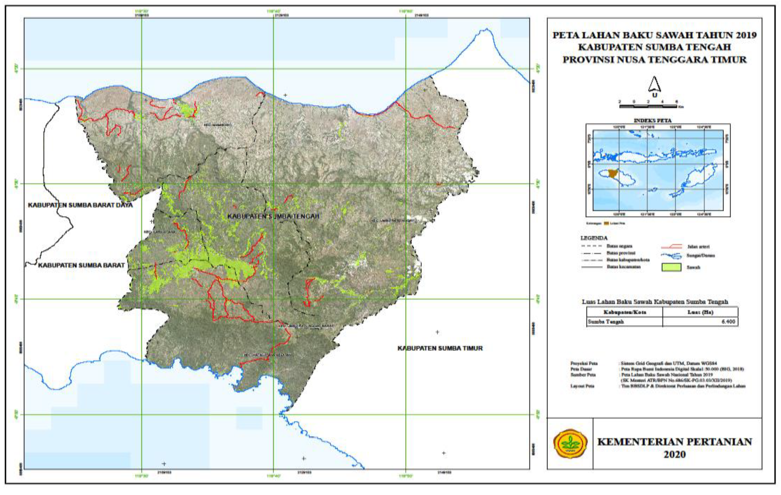
Specifically for rice field data, referring to the Raw Paddy Field Map which has now become the main reference in Indonesia, is as shown in
Figure 4.
From the Picture, the area of paddy fields is 6400 ha which is spread over 56 villages out of 65 villages in Central Sumba Regency. Although these paddy fields are spread over all sub-districts, most (79%) are concentrated in one area, which includes three sub-districts namely Umbu Ratu Nggay Barat, Katikutana and South Katikutana sub-districts.
4.2.2. Land cover changes timeline
Related to changes in land cover in the period after the formation of this district, the four types of land cover, namely Forest, Settlements and Agriculture, dry Land, the changes are described as presented in
Table 1.
Figure 5 presents landcover maps for 2013 and 2021. Meanwhile, changes in paddy fields are presented in
Table 1.
Referring to landcover changes in the
Table 1 revealed that except for Setlements, all types of land cover experienced changes that tended to decrease during the period between 2013 and 2021. This condition was a serious threat, especially the decline in forest land cover. The declining of forest areas was closely connected with the expansion setlements which was also related to the establishement of new town/capital distrcit and additional new sub-district. Especially for changes in the area of paddy fields in Central Sumba district, presented in
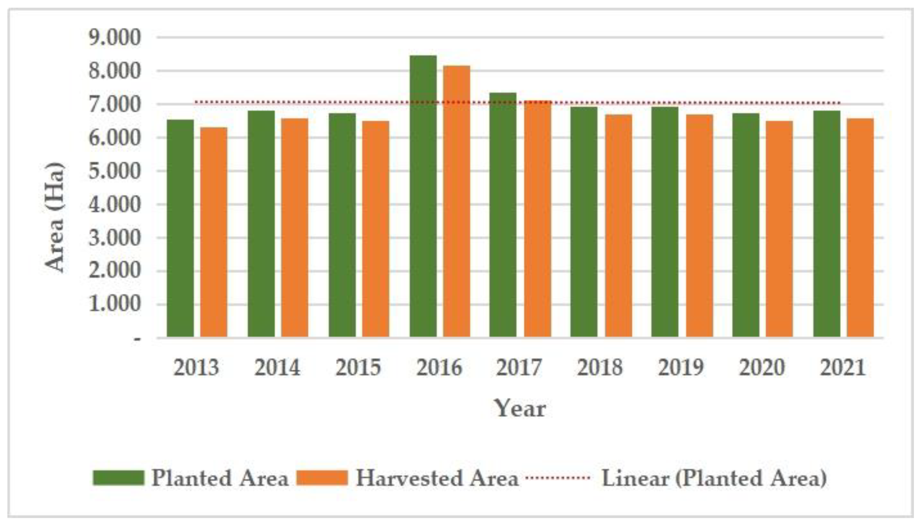
Table 2. Even though different data sources show that there is a tendency to decrease the area of paddy fields in the range from 2015 to 2019.
4.2.3. Phenomenon Physical changes of each type of landcover
The physical consequences of the area resulting from changes in land cover have been observed from the area of the four types of land cover as previously mentioned. The physical changes and their impacts are summarized in
Table 3.
The real physical changes of the four types of land cover are settlements and dry land agriculture. Changes in residential land cover tend to have a negative impact because it has shifted agricultural Land such as rice fields into visible settlements in the capital area of Central Sumba district. This threat will continue to expand if there are no regulations governing it. Confirmation results with the Government of East Sumba through the Agriculture Service, stated that the threat was indeed visible but currently the preparation of regulations governing sustainable agricultural Land or called Sustainable Food Agriculture Land (SFAL) is underway. In the near future, this regulation will be formed under the name of Regional Regulation on Sustainable Food Agricultural Land (SFAL).
Until 2021, drilled 7 unit deep wells and several large ponds with the capacity of 850,000 m3 have been built to support Food Estate Program in Central Sumba (71) . From the results of a visual analysis, before and after the construction of the ponds, the area of paddy fields tends to be constant, but the frequency of planting may be more after the construction of the ponds.
Sentinel-1 imagery data is time series by observing the dynamics of land cover change from November to October of the following year every year (
Figure 6) for 2021/22 planted since Nov 2021.
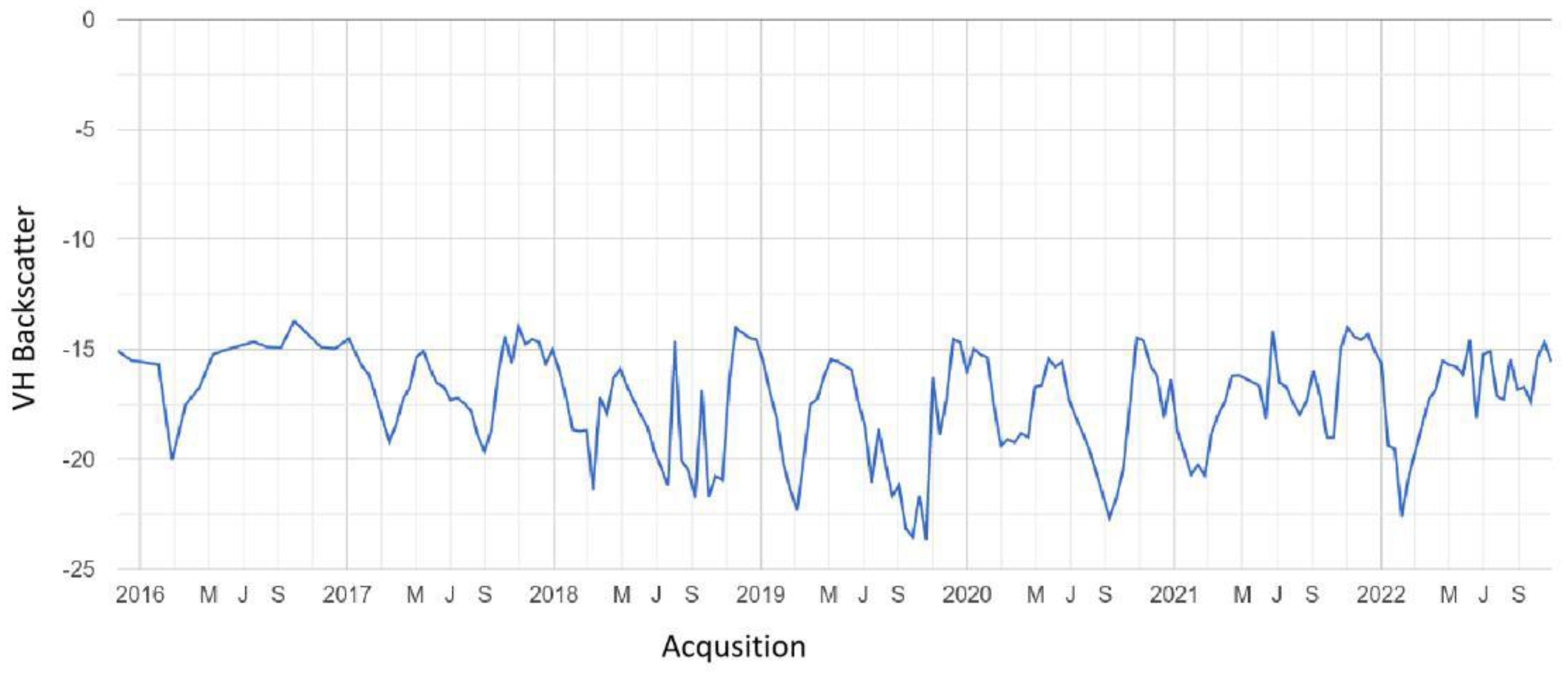
Figure 7 shows a graph of the trend of rice growth in one of the rice fields in the district studied, in 2017 it was planted 2 times in a year, while in 2022 it was planted once ina year. Visually, in 2017 and 2022, there will be no significant changes in paddy fields and forests. Orange arrows are dates that have a minimum value indicating that it is inundated. The results of image analysis at several locations are as follows:
- -
2016: planting once a year in all paddy field
- -
In 2017: there were once a year in small areas, and some areas were 2 times a year
- -
2018, 2019, 2020: 2 times a year simultaneously.
- -
Year 2021, 2022: 1-2 times a year and the 2nd growing season is not simultaneous.
Figure 8.
Trend of rice growth in one of the rice fields in the district studied.
Figure 8.
Trend of rice growth in one of the rice fields in the district studied.
4.3. Food Security: Challenges and Opportunities.
Rice is not only a main staple for Sumbanese, but also a “sacred” commodity that related to the several rituals in farming and social live of Sumbenese (72); however there has been a progressive change related to the technical aspects of farming in recent years as a direct impact of government interventions (73). As the rice land, particularly irrigated land very limited in dominated savannah environment, the land for rice is the most precious and protected land by the local people.
Traditional land tenure system in Central Sumba District in general is closely related to the social strata system where those in the upper class claims and own more land than those in the lower class, and therefore it creates “unjustice” agrarian system (74,75). Nevertheless, land ownership at least for rice land –both irrigated and rainfe-fed lowland- is still relatively equal distributed among farmers (73).
Decentralization and government interventions, especially progressive programs for rice self-sufficient in recent years have brought some gradual changes on social, cultural and technical practices in rice farming (
Table 4). The social and cultural ceremony related to rice farming is also gradually changes as most people are no longer under the local belief system, so-called
Marapu, rather accepting new religion/belief system (predominantly Christian) (72).
All respondents have their own rice land either irrigated and rain-fed lowland. Every clan also has ‘’sacred’’ rice land at least 1 ha. Beside they own and cultivate their own rice land, some farmers do cultivate pawned land. There were 16% of irrigated land and 9.8 rain-fed lowland were pawned status. The pawned status were more likely occurred due to social and cultural reasons, particularly related to burial ceremony. Pawned land transaction have been practices in recent years that correlated with the declining number of water buffalo. Water buffalo is considered as ‘’prestige’’ livestock offered during the burial ceremony. Since the price of water buffalo is unfordable, while desperate needed for burial ceremony, therefore most farmers pawn their rice land to get water buffalo.
Average land ownership for irrigated land was 0.91 ha and for rain-fed lowland was 1.2 ha. Most farmers own 1- 2 ha for irrigated land and for rain-fed lowland own 1 ha. Expenses to cultivate the land is coming from the farmers’ budget themselves. Some farmers do a bondage system to buy chemical fertilizers and paid workers (
Table 5).
There was no land ownership disparity which was shown by Gini index of 0.22 or the rice land equally distributed (deRosari, et al, 2022). This implied that (a) production, rice-based food availability, and income were well distributed among rice farmers households; (b) government intervention in terms of agriculture production facilities, agriculture infrastructures, and supporting system were equally benefitted among rice farmers households, (c) government programs to improve people well-being through agriculture development instruments – including credit capital supports- were equally distributed.
All farmers have a positive attitude and perspective on rice lands. Regarding changes in land size, majority respondents stated that there was no changes, there was close to 9% farmers experienced increased in land size and 5 % stated decreased. Majority farmers stated that the main function of both irrigated and rain-fed remains to produce rice remains, however around 3% farmers stated that the main function was change, mainly for non-agricultural purposes. Majority farmers support to keep the function of the land for rice production both in cultural ways and also supporting the government effort to protect the land through legislation (National and District Act of Sustainable and Land Protection (
Table 6).
Based on the 871 respondents' data taken from the 3 studies in Central Sumba District, the majority of respondents were in the ages 40 - < 50 years old (32%), and then followed with older ages. Younger ages of < 30 years old are quite low (5%). This figure shows and supports the general view that younger generations are not interested in working in the agricultural or farming sector, and therefore the older generation (> 60 years old) is still working in the farming sector.
The tendency for the age of farmers to be mostly old also occurs in various parts of the world.. Most of the world's food is produced by aging smallholder farmers from developing countries, who are adopting the new technologies needed to sustainably increase agricultural productivity (76). Therefore, it is necessary to re-engage youth in agriculture. One approach that must be taken is through a vocational education program in agriculture. In NTT, this model has been implemented in several districts through agricultural schools at the high school and tertiary level which attract rural youth to engage in agriculture and adopt environmentally friendly production methods. In addition, incentives through facilitating youth access to credit as well as market access help them become smallholder entrepreneurs, increasing their confidence that they can earn a living and be successful in rural areas. FAO notes that when there is an enabling environment – youth can find innovative ways to create a future for themselves, and also contribute to the society and communities in which they live (76)
Encouraging and empowering local people participation, especially the youth, in agroforestry-based upland agriculture is expected to minimize negative impact of changes in the role of forest area. Local people tradition regarding conservation and environment by integrating housing area with Kaliwu (traditional agroforestry) to enhance land cover with various trees and crops. Average collation of land for housing and house garden in Central Sumba District is 1:7 m2, which is lower than Kaliwu that take average 1:193 m2 (77). Nevertheless, upland agriculture needs to vigilantly developed due to around 46.92% of cultivated land has steep elevate (25-40%), and therefore government program for land use should be make it balance between enhancing land productivity with ecologically sustainable to avoid malpractice in land resource management.
Sustainable farming through Kaliwu development that integrated with traditional housing compound such as paraingu (Anakalang), parengu (Manggena) dan manua (Mamboro) are soio-cultural and religion, ecology and economy strategic assets (41). Socio-cultural-religiously suits with tradition of local people that develop traditional housing compound as a sub-system unit paraingu, and internalize traditional customs into a number of kabisu as a social organization clan based. Social organization is characterized by custom regulation to manage members of clan to ensure security and social kinship kabisu institution as territorial symbol such as paraingu and Kaliwu. Territorial symbol has ecology implication through conservations in hilly sides by Kaliwu approach as ecology unit and buffer around forest ecosystem. The dependence to the land resources to make living have encourages people to enhance environment services from paraingu ecosystem, among them building materials, ropes, traditional medicines, fire woods, food and forages/feed (78). Such environment services have empowering local people to be more independent and process it for their livelihoods (42). It is a lesson learnt that people in Central Sumba District has traditional spatial land, utilized marginal or unfertile lands for housing and to develops wood trees for building materials, and utilize more flat areas for upland farming, rain-fed lowland and irrigated crops lands.
4.4. Environment Services
Indonesia have increased commitment to control deforestation within and outside forest area that indicated decreased deforestation rate between 444,000-918,000 ha year-1 (2000-2009), 780,000 ha year-1 (2011-2012), and 640,000 ha year-1 (2013-2017) (48,79,80). Deforestation is mainly caused by the weakness of law enforcement, limited budget for security which around USD 13 sent ha-1, and ratio between forest ranger and forest area to be secured 1:60.000 ha in Java, Bali, and Nusa Tenggara, and 1:500.000 ha in Papua (80,81).
Decentralization policy have contributed in increasing critical/marginal land, particularly during transition period of land management from District level to Provincial level. This implied to institutional arrangement regarding forest supervision in the field. Transition periods have been misused by some individual or group of people/institution to do illegal lodging for high values trees and or forest products. This illegal lodging has most likely done with economic and political connections during decentralization era that fostering deforestation in Indonesia (82). Deforestation have broad implications to climate change, increasing death toll risks, decreases human productivity and the livelihoods of local communities (83,84). Human health or death risks is closely related air pollution and malaria prevalence (85), and therefore raise awareness of stakeholders forest based to implement strategy, policy, and institutional as well to minimize or even to eliminate deforestation in Indonesia (86,87)
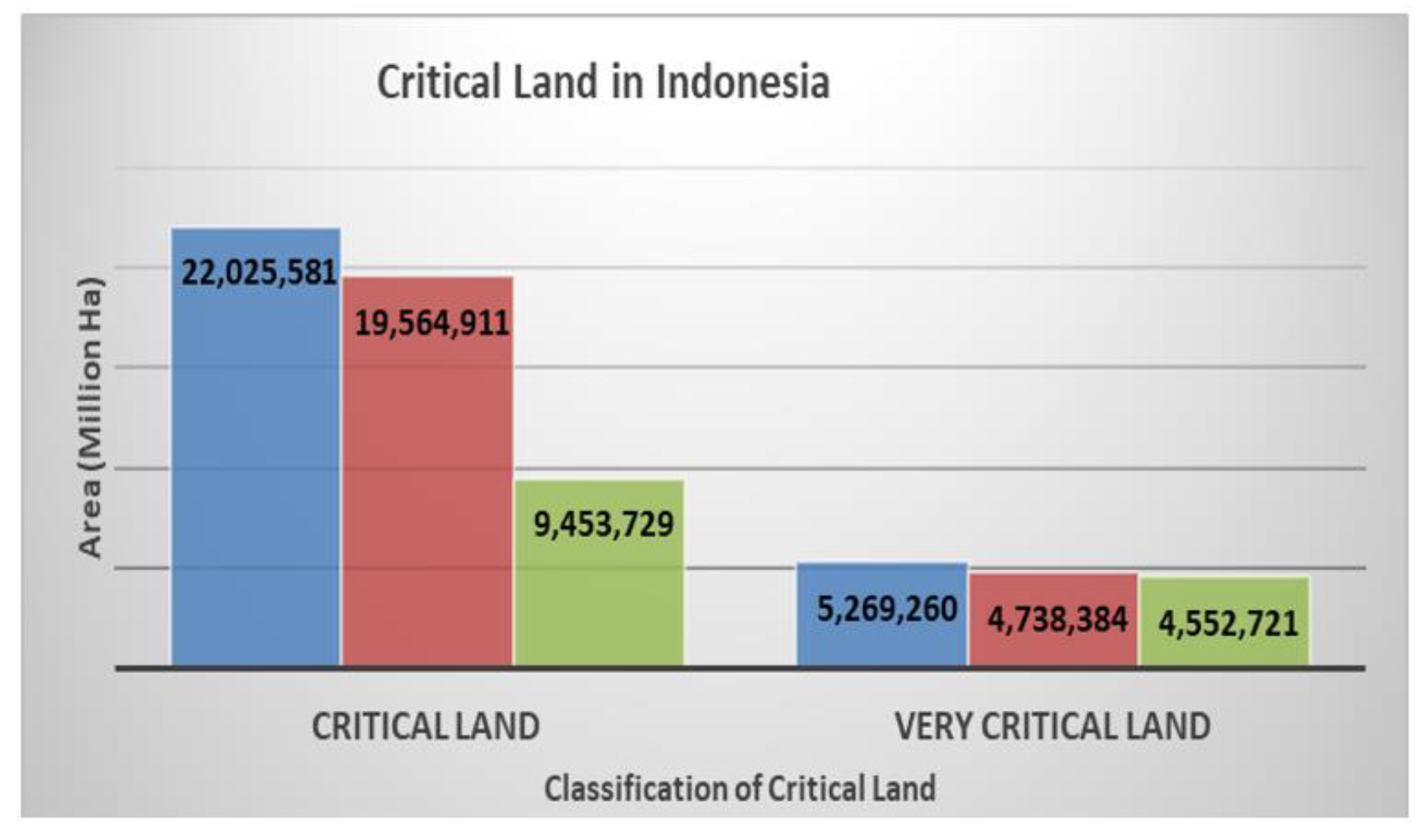
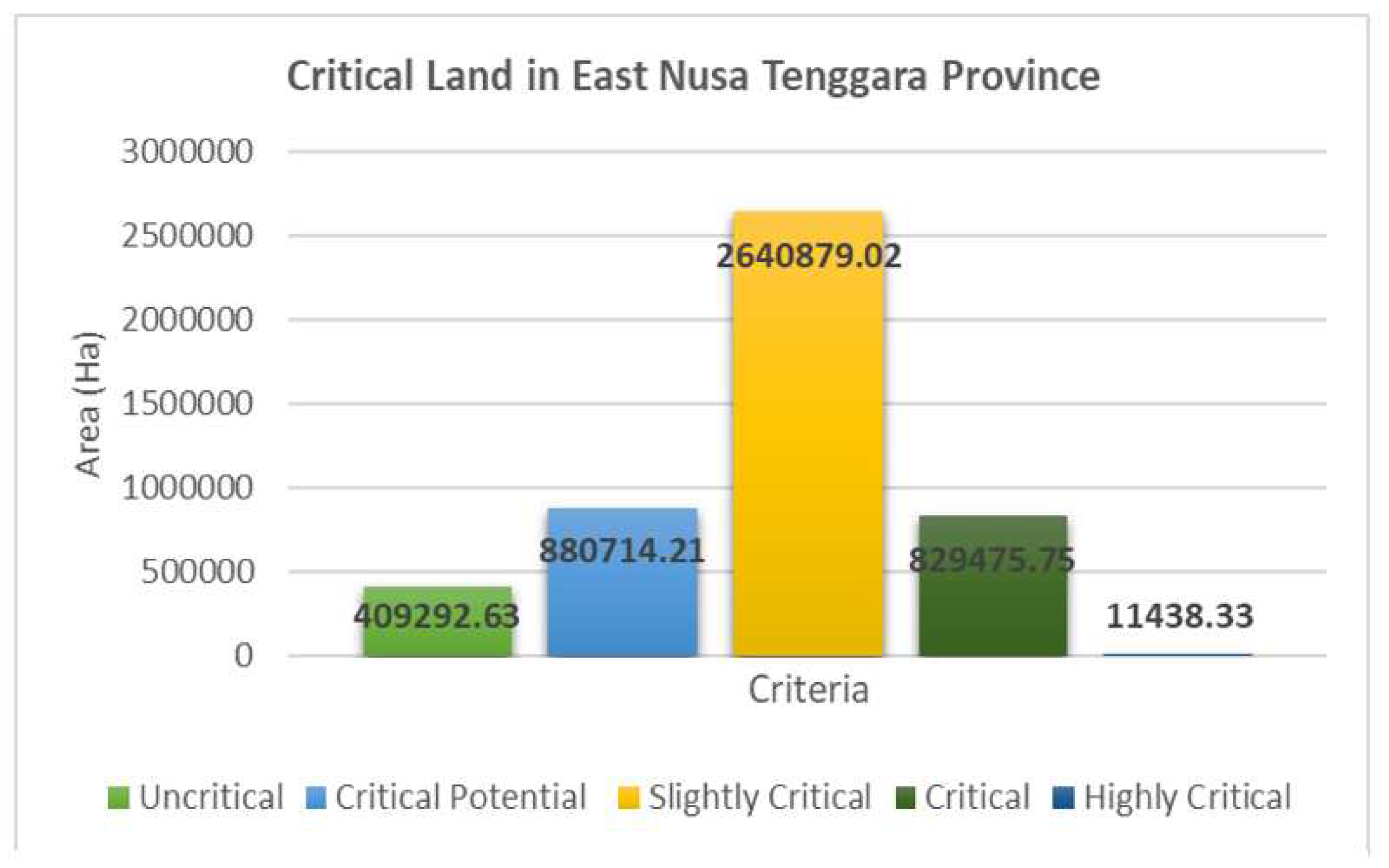
Figure 9.
Critical Land in East Nusa Tenggara Province (BPDAS Benain-Noelmina, 2022).
Figure 9.
Critical Land in East Nusa Tenggara Province (BPDAS Benain-Noelmina, 2022).
Efforts to lessen deforestation have facing challenge regarding spatial planning, land tenure system, forest management and law enforcement. Besides, at least 48.8 million people in Indonesia settled around forest, and 10.2 million among them were poor (88,89), and 2,308 (71.58%) village in ENT settled in or around State forest (90). Moreover, around 72.97% of land resources in ENT was under critical threat (
Figure 1) as the impact of increasing critical land up to 15,163 ha year
-1 compare to land rehabilitation capacity of 3,615 ha year
-1. In other side, as much 1,414,841 labor in ENT heavily dependent on land resources, and therefore sustainability of land function should be absolutely enhanced (91).
Deforestation in Sumba Island laid on its physical characteristics hilly and steep landscape, land cover dominated with bush and savannah with high risk of burning that increases critical lands. Uncritical lands outside forest areas were only 1.84%, and in the forest area was also very small of 5,40% (77). Central Sumba District as a new autonomy district face the dynamics of human population, spatial for housing, government offices, and also land for farming that change the forest area from 77,664.037 ha in 1999 (SK Menteri Kehutanan dan Perkebunan Nomor: 423/Kpts-II/1999) to 59,223.765 ha in 2021 (SK Menteri LHK Nomor: 6615/Kpts-II/2021). The request to review and redesign new forest boundary have been stimulate forest’ function change for other use. Decentralization policy and establishment of new autonomy region/district have conveyed implication changes justification of forest areas for other purposes.
Figure 10.
Critical Land in East Nusa Tenggara Province (BPDAS Benain-Noelmina, 2022).
Figure 10.
Critical Land in East Nusa Tenggara Province (BPDAS Benain-Noelmina, 2022).
4.5. Limitations and Implications for Future Studies
GIS and LCC technologies provide opportunities to better understand the trajectories of agricultural resource dynamics. However, the results of the analysis sometimes experience information bias between field conditions and the results of the image analysis used. This is because to a certain extent there are difficulties in interpreting certain objects with field conditions. Ideally, studies using imagery should be followed by field checks. As an example of practical experience, it shows that the results of image analysis are difficult to distinguish between the conditions of the mature phase of rice and grass. Therefore, the roles of field assistance and field observation are important for further clarifications.
The results of image analysis and GIS in dominated marginal areas and very limited arable land, the understanding of LCC dynamics will greatly assist policy makers in designing and implementing regional development in a more sustainable way, especially in the agricultural sector. The combination of GIS, LCC insights and socio-economic studies/confirmation offers a better understanding of dynamic changes in land use and policies to prevent and protect natural resources, especially agricultural land.
5. Discussion: The Link of Devolution Era, Food Security and Environment
Indonesia actually has enough Acts or regulations governing the land ownerships/management such as Basic Agrarian Law (Act No. 5/1960), Cultivation Act (Act No. 12/1992), and Spatial Management Act (Act No.26/2007). By referring those regulations, it hoped that well coordination among stakeholders in interpreting and implementation would minimize conflict of interest among stakeholders in land management in one side and maintaining the right of all citizens in acquiring and use the land for productive purposes in another side.
The main ideas of Decentralization and Regional Autonomy is to give more power to the local government (Provincial and District levels) for better services to the people and improve well-being, including poverty reduction in rural areas. As the majority of poor people reside in rural areas and are heavily dependent on agricultural products to get living, therefore the land -particularly agricultural land- should be well protected.
Establishment of new District and town and increasing population pressure has ultimately lead to dynamics change of land use and land cover from National, provincial up to the district levels in Indonesia. In case of ENT province, it is critical due to the region is dominated by a semi-arid environment with limited agricultural land. It was clear that there were expansions of agricultural land, particularly for rice which lead to the increasing of rice production and achievement of rice self-sufficient at least in the district level (Central Sumba). Unfortunately, it was revealed that the dynamic changes of land use were in negative directions particularly in relation to the food crops diversity, preservation of socio-cultural practices and the environment in general.
Long before those formal regulations were implemented in Indonesia, Sumbanese had their own traditional land tenure system, even for every tribe settled in Sumba. In Central Sumba district, traditional land tenure is almost following the social strata system which those in the upper stratum acquire bigger land size than the lower strata. The research showed that this traditional land tenure is still acknowledge, however all people have also their own or private land, at least for rice land.
Recent national progress in economic development and responding the spirit of decentralization and regional autonomy, some new provinces and District have been created which have direct consequences land conversion and land fragmentations. In ENT province, 10 new Districts created make it total 22 Districts. Unfortunately, all new district have created before District Sustainable Agricultural Land Act passed. In case of Central Sumba District, the district’s capital, putted even in the core rice land area.
Land cover changes and the dynamics of social and economic perspectives of land in Central Sumba District were more likely dictated by the development of new district/town/urban areas as a direct consequence of the National policy to give more power and autonomy for local governments to foster the well-being of the people. Although the current changes so far have little impact on land conversion and land ownership, it should be manage in such a way to protect the agricultural land and ensure food security.
6. Conclusions
Agricultural land is very limited in Sumba Island that dominated with marginal semi-arid ecosystem. Nevertheless, land use and land cover changes may continue to meet the demand for food of growing human population. Rice land in Central Sumba District is a precious land for food security which has cover only 5 % of the total district size. The on-going conversion of the land even at a slow rate should be taken into consideration as it will affect the food security of the people and its environmental impacts. Semi-arid ecosystem is a fragile ecosystem that should be well managed to ensure the provision of food security and environmental services.
New district and new town created during decentralization and autonomy era in Indonesia has created new urban society that needs land and space for urban infrastructure. The placement of the town in the core of agricultural land in Central Sumba district has undermined the sustainability of limited food crops and food security. The increase of land price and land rent were inevitable in the new town. Therefore, to limit conversion of agricultural land in the town and suburb, there should be clear regulation of the land ownership transfer and in the same time it needs government support to make the land more productive or competitive through various schemes in agricultural programs.
Supplementary Materials
Not Applicable.
Author Contributions
YN (Yohanis Ngongo), BdR, TB, GNN, YN (Yudistira Nugraha), AHH, MA, K, RS, RBH, JBNR, JOMS, RES, HdS, RTPH, PRM, YPK, NREK, YLK, DKH, DO, HYSH, made equal contribution to data collection, conceptualzation, methodology, analysis, validation, manuscript writing, review and editing. All authors have read and agreed to the re-submission version of the manuscript.
Funding
This research funded by Local Government of Central Sumba District based on Central Sumba Major Decree Number: Kep/HK/295/2002, under the management of District Development Planning Board; while for the APC receives no external funding.
Data Availability Statement
Not applicable.
Acknowledgments
The authors highly appreciated the contributions and the supports from some Institutions and Individuals. We thanks to the government of Central Sumba District for allocating the fund to conduct the study. We thanks to the Chair of the Regional Research and Development Planning Agency: Dr. Martinus Jurumana for constructive ideas during Seminar/data collection stage and for allowing several staff (Nevelyn Rambu Bangi Todji, Marlyn Rambu Bita, and Gusti Kadek Deddy B. Ivan) to be involved in the research. We acknowledge and thank you for the contribution from agricultural extension workers of Central Sumba District in helping collecting the survey data. Thank you also goes to Ferdinand Umbu Kabalu, SE, Lasarus Thomas, S.Sos and Neny Rambu Lawadjati, ST for managing our administrative travel and field documents.
Conflicts of Interest
The authors declare no conflict of interest.
References
- Nurhadi. Inilah Daftar Provinsi Baru yang Terbentuk pasca-Reformasi. Tempo [Internet]. 2022 Jul;Nasional. Available online: https://nasional.tempo.co/read/1608931/inilah-daftar-provinsi-baru-yang-terbentuk-pasca-reformasi.
- Fajri DL. Mengenal Provinsi dan Jumlah Kabupaten di Indonesia. Katadata [Internet]. 2022 Feb;Berita. Available online: https://katadata.co.id/intan/berita/6206141e9ca33/mengenal-provinsi-dan-jumlah-kabupaten-di-indonesia.
- Pratomo RA, Samsura DAA, Krabben E van der. Transformation of Local People ’ s Property Rights Induced by New Town Development. Land. 2020, 9, 25.
- Kelly-Fair M, Gopal S, Koch M, Kusumaningrum HP, Helmi M, Khairunnisa D, et al. Analysis of Land Use and Land Cover Changes through the Lens of SDGs in Semarang, Indonesia. Sustain 2022, 14.
- Mardiansjah FH, Rahayu P, Rukmana D. New Patterns of Urbanization in Indonesia: Emergence of Non-statutory Towns and New Extended Urban Regions. Environ Urban ASIA. 2021, 12, 11–26.
- Handayani SW, Fauzan M, Nasihuddin AA. Conversion of Agricultural Land Policy in Indonesia. 2018.
- Laksana, S. Some Difficulties to Protect Agricultural Land from Conversion: The Case of Sustainable Agricultural Land Policy In Tasikmalaya Regency, West Java, Indonesia [Internet]. Jakarta 2020. Report No.: 3. [Google Scholar]
- Agus F, Irawan. Agricultural Land Conversion as a Threat to Food Security and Environmental Quality. J Penelit dan Pengemb Pertan. 2006, 25.
- Firman, T. Rural to urban land conversion in Indonesia during boom and bust periods. Land use policy. 2000, 17, 13–20. [Google Scholar] [CrossRef]
- Mulyani A, Kuntjoro D, Nursyamsi D, Agus F. Konversi Lahan Sawah Indonesia sebagai Ancaman terhadap Ketahanan Pangan. Indones Soil Clim J. 2016, 40.
- Handayani SW, Fauzan M, Nasihuddin AA. Conversion of Agricultural Land Policy in Indonesia. 2018, 231, 252–4.
- Nurliani, Rosada I. Rice-field Conversion and its Impact on Food Availability. Agric Agric Sci Procedia [Internet]. 2016, 9, 40. [CrossRef]
- Sidipurwanty, E. Tenure and Ownership of Agricultural Land in Probolinggo Regency of East Java Province. Pertanahan. 2016.
- Putri RF, Rokhim AA, Prakosa MG, Hastari NRF, Adhesti YMP, Junaedi RN, et al. Analysis of land resources balance in Nusa Tenggara Timur Province. IOP Conf Ser Earth Environ Sci. 2021, 686, 0–13.
- Hutapea RTP, Ramadhan RP, Tulalo MA, Ngongo Y. Competitiveness of Indonesian Rice Prices in The International Market. E3S Web of Conferences 2022, 361, 01016. [CrossRef]
- Yodfiatfinda. Effort to Improve the Interests of Young Generations in the Agricultural Sector to Attain Food Security in Indonesia. 2020, 194, 291–296.
- Utami A, Harianto H. Farmers’ Subsistence in Indonesian Rice Farming. J Agribisnis Indones. 2021, 9, 79–87.
- Rosyada A, Putra RE, Gunawan W. Dynamics of Competitiveness and Efficiency of Rice Farming in Java Island, Indonesia. 2022, 4, 105–19.
- Ministry of Finance Repuclic of Indonesia. Law of the Republic of Indonesia Number 28 Year 2009 Concerning Local Taxation and Charges [Internet]. Jakarta, 2010. Available online: https://djpk.kemenkeu.go.id/attach/post-law-of-the-republic-indonesia-number-2008-year-2009-concerning-local-taxes-and-charges/UU-559-753-uu282009verE_Edited.pdf.
- Usman, S. Regional Autonomy in Indonesia : Field Experiences and Emerging Challenges The conference jointly organized by : Indonesian. SMERU Work Pap [Internet]. 20 July 2002, pp. 20–21. Available online: www.smeru.or.id.
- Sukri, Ariana, Armunanto A, Nadir S, Ekawaty D. Environmental dilemma under implementation of Indonesian regional autonomy. IOP Conf Ser Earth Environ Sci. 2019, 343.
- Wiesner BJ, Dargusch P. The Social License to Restore—Perspectives on Community Involvement in Indonesian Peatland Restoration. Land 2022, 11.
- Yakin A, Othman J. Forest Resources and Policy in the Age of Regional Autonomy in Indonesia. In International Seminar on “Sustainable Economic, Business, and Social Development in an Era of Globalization; Selangor, Malaysia, 2003.
- Setiawan B, Hadi SP. Regional autonomy and local resource management in Indonesia. Asia Pac Viewp. 48, 72–84. [CrossRef]
- Republic of Indonesia. The National Medium Term Development Plan 2020 - 2024. Indones Natl Dev Plan Board [Internet]. 2020. Available online: https://www.bappenas.go.id/files/rpjmn/Narasi-RPJMN-2020-2024-versi-Bahasa-Inggris.pdf.
- Sutiyo, M.K.L. Decentralization and Rural Development in Indonesia. Decentralization Rural Dev Indones. 2017.
- Nurrochmat DR, Pribadi R, Siregar H, Justianto A, Park MS. Transformation of agro-forest management policy under the dynamic circumstances of a two-decade regional autonomy in Indonesia. Forests. 2021, 12, 1–17.
- Rada NE, Buccola ST, Fuglie KO. Government policy and agricultural productivity in Indonesia. Am J Agric Econ. 2011, 93, 863–80.
- Nugroho Y, Sujarwoto. Institutions, Outputs and Outcomes: Two Decades of Decentralization and State Capacity in Indonesia. J Southeast Asian Econ. 2021, 38.
- Johnson, C. Local democracy, democratic decentralisation and rural development: Theories, challenges and options for policy. Dev Policy Rev. 2001, 19, 521–32. [Google Scholar] [CrossRef]
- Nasution, A. The government decentralization program in indonesia. Cent Local Gov Relations Asia Achiev Fisc Sustain. 2017, 276–305. [Google Scholar]
- Shoesmith D, Franklin N, Hidayat R. Decentralization and the decision making process are more democratic, but it also enhances fragmentations and conflicts among different parties, including in natural resources management, especially in agricultural land. J Curr Southeast Asian Aff. 2020, 39, 359–80.
- Ardiansyah F, Marthen AA, Amalia N. Forest and land-use governance in a decentralized Indonesia: A legal and policy review; CIFOR: Bogor, Indonesia, 2015. [Google Scholar]
- Garrett L, Lévite H, Besacier C, Alekseeva N, And, Duchelle A. The key role of forest and landscape restoration in climate action [Internet]. FAO: Rome, 2022. Available online: https://www.fao.org/3/cc2510en/cc2510en.pdf.
- Zhang, S. Land Use/ Land Cover Change in Orange County. 2010. (January). Available online: https://cdr.lib.unc.edu/indexablecontent/uuid:d45807b0-f8ea-4d19-83b8-b0b44b0e74a3.
- Vadrevu KP, Ohara T. Focus on land use cover changes and environmental impacts in South/Southeast Asia. Environ Res Lett. 2020, 15.
- Lin HI, Yu YY, Wen FI, Liu PT. Status of Food Security in East and Southeast Asia and Challenges of Climate Change. Climate. 2022, 10.
- Margulis, S. Causes of deforestation in the Brazilian Amazon [electronic resource] [Internet]. 2003. Available online: http://search-dev.trln.org/shopping-cart/search?id=UNCb5124852; Full text available via the UNC-Chapel Hill Libraries (http://eresources.lib.unc.edu/external_db/external_database_auth.html?A=P%7CF=N%7CID=1405%7CREL=AAL%7CURL=http://libproxy.lib.unc.edu/lo.
- Cerri CEP, Cerri CC, Maia SMF, Cherubin MR, Feigl BJ, Lal R. Reducing Amazon deforestation through agricultural intensification in the Cerrado for advancing food security and mitigating climate change. Sustain. 2018, 10, 1–18.
- Appelt JL, Garcia Rojas DC, Verburg PH, van Vliet J. Socioeconomic outcomes of agricultural land use change in Southeast Asia. Ambio [Internet]. 2022, 51, 1094–109 Available from:. [CrossRef]
- Zhao S, Peng C. Land use change in Asia and the ecological consequences. Ecol Res. 2006, 21, 890–6. [CrossRef]
- Vadrevu K, Heinimann A, Gutman G, Chris J. Remote sensing of land use/cover changes in South and Southeast Asian Countries. 2019, 12. Int J Digit Earth [Internet]. 2019, 12. [CrossRef]
- District Statistical Bureau. Kabupaten Sumba Tengah Dalam Angka 2022 (Central Sumba District in Figures 2022). [Internet]. Statistical Bureau. Waibakul. Available online: https://sumbatengahkab.bps.go.id/publication/download.html?nrbvfeve=YmIzYzA5OTVmNzM1NjU4ZWZjYzIzNDIz&xzmn=aHR0cHM6Ly9zdW1iYXRlbmdhaGthYi5icHMuZ28uaWQvcHVibGljYXRpb24vMjAyMi8wMi8yNS9iYjNjMDk5NWY3MzU2NThlZmNjMjM0MjMva2FidXBhdGVuLXN1bWJhLXRlbmdhaC1kYWxhbS1hb.
- Geospatial, I. Indonesia Geospasial. 2019. Available online: https://www.indonesia-geospasial.com/2020/09/download-shp-tutupan-lahan-tahun-2019.html.
- Indra S, Prasetyo LB, Soekmadi R. PENYUSUNAN ZONASI TAMAN NASIONAL MANUPEU TANADARU, SUMBA BERDASARKAN KERENTANAN KAWASAN DAN AKTIFITAS MASYARAKAT (Zoning System Development of Manupeu Tanadaru National Park on Sumba based on Area Sensitivity and Community Activities). Media Konserv 2006, XI, 1–16.
- RimbaKita. Taman Nasional Manupeu Tanah Daru – Sumba, NTT [Internet]. RimbaKita. 2022. Available online: https://rimbakita.com/taman-nasional-manupeu-tanah-daru/.
- Olson, D. Sumba Deciduous Forests [Internet]. Oenerath - WWF-Hong Kong. 2022. Available online: https://www.oneearth.org/ecoregions/sumba-deciduous-forests/.
- Hanif Faisol Nurofiq, Margono BA, Saputro T, Nugroho S, Purwanto J, Ramdhany D, et al. The State of Indonesia ’ s Forests 2022: Towards FOLU Net Sink 2030 [Internet]. Nurbaya S, Efransyah, editors. Jakarta: Ministry of Environmental and Forestry Republic of Indonesia. 2022. Available online: https://www.menlhk.go.id/uploads/site/post/1664894502.pdf.
- DeRosari B, Matitaputy PR, Ngongo Y, Silva H da, Rohi I, Bombo Y, et al. Laporan Kerjasama Bapelitbangda Sumba Tengah dan BPTP NTT. 2021.
- DeRosari B, Basuki T, Ngongo Y. Dampak Sosial Budaya dan Ekonomi Program Food Estate Bagi Kesejahteraan Masyarakat Suma Tengah (Impact of Socio-cultural and Economic of Food Estate Program for People Welfare of Central Sumba Distrcit). Waibakul, 2022.
- Basuki T, DeRosari B, Pari NUK, Landukara Y, Banunaek SKI, Bitang BK, et al. Kajian Lahan Pertanian Pangan Mendukung Perda LP2B Kabupaten Sumba Tengah (The Study to provides document of “Sustainable Food Crops Lands” in Central Sumba District). Waibakul, 2022.
- Hudjimartsu S, Prasetyo L, Setiawan Y, Suyamto D, Ikbal W. Automated Landsat 8 data preprocessing for national forest monitoring system. In Sixth International Conference on Remote Sensing and Geoinformation of the Environment (RSCy2018); SPIE, 2018; pp. 249–259.
- Candra DS, Phinn S, Scarth P. Automated cloud and cloud-shadow masking for Landsat 8 using multitemporal images in a variety of environments. Remote Sens. 2019, 11.
- Kustiyo -, Dianovita -, Ismaya H, Rahayu MI, Adiningsih ES. New Automated Cloud and Cloud-Shadow Detection Using Landsat Imagery. Int J Remote Sens Earth Sci. 2014, 9.
- López-Puigdollers D, Mateo-García G, Gómez-Chova L. Benchmarking deep learning models for cloud detection in landsat-8 and sentinel-2 images. Remote Sens. 2021, 13, 1–20.
- Phiri D, Simwanda M, Salekin S, Nyirenda VR, Murayama Y, Ranagalage M. Sentinel-2 data for land cover/use mapping: A review. Remote Sens. 2020, 12.
- Supriatna, Rokhmatuloh, Wibowo A, Shidiq IPA, Pratama GP, Gandharum L. Spatio-temporal analysis of rice field phenology using Sentinel-1 image in Karawang Regency West Java, Indonesia. Int J GEOMATE. 2019, 17, 101–6.
- Andualem TG, Belay G, Guadie A. Land Use Change Detection Using Remote Sensing Technology. J Earth Sci Clim Change. 2018, 9.
- Roy PS, Roy A. Land use and land cover change in India: A remote sensing & GIS prespective. J Indian Inst Sci. 2010, 90, 489–502.
- Kumar MS, Kolluru V, Gowthami SB, Anjita NA, Nayana N, Regi L, et al. Monitoring land use and land cover changes in coastal karnataka. 2021, 99, 785–95.
- Kumar A, Chaudhary S, Negi MS. a Study of Spatio-Temporal Landuse/Land Cover Change Dynamics in Rudraprayag District,(Garhwal Himalaya) Using Remote Sensing and Gis. J Glob Resour Vol. 2019, 5, 61–9.
- Naboureha A, Biana J, Leia G, Lia A. A review of land use/land cover change mapping in the China-Central Asia-West Asia economic corridor countries. IG EARTH DATA. 2021, 5, 237–257. [CrossRef]
- Parveen S, Basheer J, Praveen B. a Literature Review on Land Use Land Cover Changes. Int J Adv Res. 2018, 6, 1–6. [CrossRef] [PubMed]
- Venter ZS, Barton DN, Chakraborty T, Simensen T, Singh G. Global 10 m Land Use Land Cover Datasets: A Comparison of Dynamic World, World Cover and Esri Land Cover. Remote Sens. 2022, 14.
- Filipponi, F. Sentinel-1 GRD Preprocessing Workflow. 2019; 11. [Google Scholar]
- Hollander M, Wolfe DA, Chicken E. Nonparametric Statistical Methods; John Wiley & Sons.: New York, 2014. [Google Scholar]
- Central Sumba District Statistical Bureau. Sumba Tengah Dalam Angka 2021 (Central Sumba District in Figures 2021); Waibakul, 2021. [Google Scholar]
- Central Sumba District Statistical Bureau. Sumba Tengah Dalam Angka 2015 (Central Sumba District in Figures 2015); Waibakul, 2015. [Google Scholar]
- Central Sumba District Statistical Bureau. Sumba Tengah Dalam Angka 2016 (Central Sumba District in Figures 2016); Waibakul, 2016. [Google Scholar]
- Central Sumba District Statistical Bureau. Sumba Tengah Dalam Angka 2017 (Central Sumba District in Figures 2017); Waibakul, 2017. [Google Scholar]
- Azwartika, I. Menteri Basuki Dampingi Presiden Joko Widodo Tinjau Infrastruktur Irigasi Food Estate Kabupaten Sumba Tengah, NTT [Internet]. Jakarta. 2021. Available online: https://pu.go.id/berita/menteri-basuki-dampingi-presiden-joko-widodo-tinjau-infrastruktur-irigasi-food-estate-kabupaten-sumba-tengah-ntt.
- Ngongo Y, Ngongo M. Marapu and Farming: How Tourism Shape Rural Development and Ancient Tradition of Sumba Indigenous Community – Indonesia. E3S Web Conf. 2021, 316, 04004. [CrossRef]
- DeRosari, B.; Basuki, T.; Ngongo, Y. Kajian Pola Penguasaan Lahan Sawah di Kabupaten Sumba Tengah (Study of Rice Land Tenure in Central Sumba District); Waibakul, 2022. [Google Scholar]
- Vel, J. Law, Social Justice & Global Development Reports. Law, Soc Justice Glob Dev [Internet]. 2010, 2010, 1–27. Available online: http://www2.warwick.ac.uk/fac/soc/law/elj/lgd/2010_1/vel/vel.pdf.
- Vel J, Makambombu S. Strategic Framing of Adat in Land-Acquisition Politics in East Sumba. Asia Pacific J Anthropol [Internet] 2019, 20, 435–452. [CrossRef]
- FAO. Youth and Agriculture. The Food and Agriculture Organization of the United Nations (FAO) in collaboration with the Technical Centre for Agricultural and Rural Cooperation (CTA) and the International Fund for Agricultural Development (IFAD. 2014; pp. 1–6. [Google Scholar]
- Njurumana, GN. Village Community and Flora Biodiversity Management in Home Garden System at Central of Sumba Regency. J Penelit Kehutan Wallacea. 2016. [CrossRef]
- Njurumana GN, Sadono R, Marsono D, Irham. Ecosystem Services of Indigenous Kaliwu Agroforestry System in Sumba, Indonesia. E3S Web of Conferences 2021, 04002.
- Margono BA, P. Potapov P, Turubanova S, Stolle F, Hansen MC. Primary forest cover loss in Indonesia over 2000–2012. Nat Clim Chang. 2014, 4, 730–5. [CrossRef]
- Tacconi L, Rodriguesa RJ, Maryudi A. Law enforcement and deforestation: Lessons for Indonesia from Brazil. For Policy Econ [Internet] 2019, 108. [CrossRef]
- Ekawati, S. Evaluation of the Implementation of Decentralization Policy on Production Forest Management. J Anal Kebijak Kehutan. 2013, 10, 187–202. [Google Scholar]
- Cisneros E, Kis-Katos K, Nuryartono N. Palm oil and the politics of deforestation in Indonesia. J Environ Econ Manage 108.
- Chakrabarti, A. Deforestation and infant mortality: Evidence from Indonesia. Econ Hum Biol. 2021, 40. [Google Scholar] [CrossRef] [PubMed]
- Wolff NH, Zeppetello LRV, Parsons LA, Aggraeni I, Battisti DS, Ebi KL, et al. The effect of deforestation and climate change on all-cause mortality and unsafe work conditions due to heat exposure in Berau, Indonesia: a modelling study. Lancet Planet Heal. 2021, 5, e882–92. [CrossRef] [PubMed]
- Kim Y, Knowles S, Manley J, Radoias V. Long-run health consequences of air pollution: Evidence from Indonesia’s forest fires of 1997. EconHumBiol 2017, 186–198.
- Leijten F, Sim S, King H, Verburg PH. Local deforestation spillovers induced by forest moratoria: Evidence from Indonesia. Land use policy [Internet] 2021, 109, 105690. [CrossRef]
- Darmawan A, Hospes O, Termeer CJAM. Between zero-deforestation and zero-tolerance from the state: Navigating strategies of palm oil companies of Indonesia. For Policy Econ. 2022, 126.
- Wollenberg E, Moeliono M, Limberg G, Iwan R, Rhee S, Sudana M. Between state and society: Local governance of forests in Malinau, Indonesia. For Policy Econ. 2006, 8, 421–33.
- Siscawati M, Banjade MR, Liswanti N, Herawati T, Mwangi E, Wulandari C, et al. Overview of forest tenure reforms in Indonesia [Internet]. Working Paper 223. Bogor; 2017. Report No.: 223. Available online: https://www.cifor.org/publications/pdf_files/WPapers/WP223Siscawati.pdf.
- NJURUMANA GN, GINOGA KL, OCTAVIA D. Sustaining farmers livelihoods through community forestry in Sikka, East Nusa Tenggara, Indonesia. Biodiversitas J Biol Divers 2020, 21.
- ENT Statistical Burau. Nusa Tenggara Timur Dalam Angka 2021 (ENT in Figures 2021) [Internet]. Kupang. 2022. Available online: https://ntt.bps.go.id/publication/2021/02/26/28a3d01a29a82489c3f95190/provinsi-nusa-tenggara-timur-dalam-angka-2021.html.
|
Disclaimer/Publisher’s Note: The statements, opinions and data contained in all publications are solely those of the individual author(s) and contributor(s) and not of MDPI and/or the editor(s). MDPI and/or the editor(s) disclaim responsibility for any injury to people or property resulting from any ideas, methods, instructions or products referred to in the content. |
© 2023 by the authors. Licensee MDPI, Basel, Switzerland. This article is an open access article distributed under the terms and conditions of the Creative Commons Attribution (CC BY) license (http://creativecommons.org/licenses/by/4.0/).
