Preprint
Article

Rainwater and Wastewater Management: A Case Study of Dakar’s Built-up area, Senegal

Altmetrics

Downloads

174

Views

128

Comments

0

This version is not peer-reviewed

Submitted:

21 March 2023

Posted:

23 March 2023

You are already at the latest version

Alerts
Abstract
Urban water management rules have long been oriented towards the rapid disposal of rainwater and wastewater through combined or separate drainage networks. This type of urban water management has shown its limits in both developed and undeveloped countries, notably because of its inexorable degradation over time and the cost of its rehabilitation and adaptation to the increase in demand due to urban growth. Sanitation data from the Office Nationale de l’Assainissement du Sénégal. Rainfall data are processed and analyzed to describe the current situation and how variable and high rainfall affects the neighborhood. Approximately 70-92% of the Dakar region's inhabitants have on-site sanitation facilities and sufficient income makes it difficult to manage their wastewater without exposing the environment or the health of citizens. The volumes of domestic wastewater flowed into the environment, in addition to poorly evacuated rainwater, show that the current sanitation system in the Dakar region is largely outdated, and insufficient for an effective drainage of rainwater and wastewater. Increasingly, frequent flash floods of polluted storm water from large amounts of domestic sewage are occurring, resulting in damage to human health. Exceptionally high rainfall is in correlation with high daily rainfall, therefore in recent years daily rainfall higher than 100 mm have been recorded in connection with above-average annual rainfall. That increase in rainfall disrupts the drainage of wastewater in the region of Dakar. A pragmatic and voluntary policy based on the principles of ecohydrology to recreate natural areas will be the only way for Dakar to efficiently manage storm water and wastewater. It can bring Dakar in 2030 into the international group of sustainable green cities.
Keywords: 
Subject: Environmental and Earth Sciences  -   Water Science and Technology

1. Introduction

Rainwater drainage and wastewater management in cities like Dakar represent a public health challenge. With the population growth and rapid globalization of the late 2000s, urban development is inevitable on the planet. Adaptation to climate change will therefore require the ability to adapt cities to new climatic and economic development conditions [1]; [2]. Exposure to flooding increased by 20-24% during 2000-2015 [3]; [4]. Changes in flood risk observed in recent decades are due to human factors such as urbanization and population growth rather than climate change alone [5]; [4]. Flooding intensifies the mixing of stormwater with wastewater and the redistribution of pollutants ([6]; [4]). In addition, contaminated floodwater poses an immediate health risk through water-related diseases [7]; [6]; [8]; [9]; [4]). Furthermore, floodwater contamination decreases aesthetic value compromising recreational activities, tourism attractiveness, property values, and drinking water management and treatment [10]; [4]). Water, Sanitation and Health, WaSH, form a close dependency. Variations in temperature, rainfall, and extreme events cause an increase in the incidence of water-related diseases and neglected tropical diseases ([4]). In Senegal, the rainy season corresponds to an 84% increase in the risk of diarrhea in children ([4]). High levels of fecal contamination of drinking water and hands have been associated with an increase in childhood diarrhea ([4]). Overflowing sewage leads to a 13% increase in the risk of gastrointestinal illness from source water contamination ([4]).
Despite the magnitude of the impacts caused by sanitation deficiencies, more attention has been directed to the provision of potable water than to increasing the capacity of sewage and stormwater systems to accommodate heavier rainfall ([4]). Urbanization must respond to both local and global challenges, respecting the three components Economy/Society/Environment. To this end, the concept of "green city" has emerged in recent years to meet the expectations of the SDGs. However, there is not yet a well-defined model. Historically, the notion of "sustainable city" replaced the notion of "ecological city" at the time of the Rio Conference in the 1990s. Environmental concerns were then linked to urban planning projects and economic, social and cultural constraints [11]; [12]: the main interest was then the search for the well-being of city populations [13]:. Thus, green cities refer to the development of communities that do not exceed the ecosystem's carrying capacity under the term "urban footprint" [13]; [15]; [16]. It promotes a holistic approach integrating social, economic, ecological and engineering sciences. It is within this framework that the notion of a sustainable green city can be linked to that of integrated urban water resources management. The notion of "green city" thus implies water supply facilities, garbage and wastewater disposal and treatment, regeneration of green spaces and water points, transportation regulation, energy consumption, etc. [17]. But the notion of a sustainable "green city" now goes beyond simple land use planning. It aims to develop a resilient and sustainable urban environment, where the circular economy would reduce environmental impacts by emphasizing green spaces and balance with nature. [18]; [19] . It engages with local land use policies, in continuous interaction with citizens and decision makers, for the support of economically and environmentally viable, socially accepted and time-efficient solutions.
Even if taking the environment into account is increasingly common in urban development, changing urban development as it has been practiced for decades means changing the paradigm, which is a difficult, complex and innovative process, especially in African cities. The situation in Dakar (Senegal) is worth considering. The unregulated settlement of new urban dwellers often takes place in risky areas (low-lying areas, flood zones, swamps, shores, etc.) where the lack of RainWater Management (RWM) can have serious consequences for infrastructure and public health, due to poorly drained stagnant water. This is all the more serious as the water quickly mixes with the overflow of sewerage, where drainage infrastructure is poorly maintained or non-existent. The water is then polluted and the residents affected by the floods require health care. The stagnation of water causes people to be in constant contact with unsafe water, debris, and live in poor hygiene conditions [20]. This leads to skin diseases, respiratory infections or diarrheal diseases, which are highly prevalent in the region of Dakar of [21]; [22] Due to inefficient sanitation systems, the water table is polluted with high levels of nitrates and coliforms from contamination by black water [23]. For example, the lack of sanitation systems in the outskirts of Dakar has led to an increase in nitrate levels that are now very high (between 160 and 350 mg/l), well above the WHO drinking water standard of 50 mg/l [20]; [24]; [24]).
StormWater management (SWM) is becoming a crucial issue for sustainable development in new urban areas as is often the case in African cities. Similarly, the growing interest in sanitation focuses mainly on wastewater management, and takes too little account of SWM, which remains a less important topic often considered only at the time of disastrous one-off events causing uncontrollable and destructive floods [25] . This is why, as an innovative approach in the management of development and urban environment, ecohydrology brings new tools for city actors to build a "sustainable green city" (SGC) as a performing, responsible and ecological city. It is within this framework that this paper considers the sustainability of Dakar in terms consequences of stormwater drainage on wastewater management. The choice of the Dakar region as a study site is justified by the availability of numerous national policy documents for an ecological model of SGC in West Africa, notably through the implementation of the Senegalese Emerging Plan (Plan Sénégal Emergent (PSE), phase 1: 2014-2018; phase 2: 2019-2023), which spearheads Senegal's national land use planning policy.

2. Study area

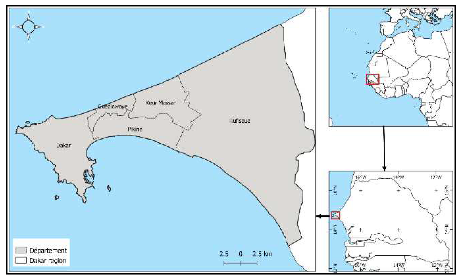
With an area of 547 km2, the Dakar Region is home to 4,146,593 inhabitants in 2023 [26], or 23% of the Senegalese population. The Dakar Region is divided into five departments, namely Dakar, Pikine, Guédiawaye, Keur Massar, and Rufisque, with its communes where density is unevenly distributed (Figure 1). The high urbanization of the Dakar Region is essentially linked to a high concentration of factories and administrations, in addition to a high rate of rural exodus. The acceleration of urban growth has not been accompanied by significant infrastructure programs. The access to basic services remains low, at 33 percent [26]. Natural resources, as well as the human environment and the few "still" green spaces, are the targets of repeated pollution and nuisances of ever-increasing scale.
Figure 1. Study area.
Preprints 70050 g001

2. Materials and Methods

For the five departments of the Dakar Region, the calculation of domestic wastewater flows was based on data published by ONAS (Office National de l’Assainissement du Sénégal) and [26]. The state of the sewerage system was assessed on the basis of a bibliographical study and field work. Station rainfall data were collected at the National Weather Service (ANACIM: Agence Nationale de l’Aviation Civile et de la Météorologie). The annual rainfall data and the maximum daily rainfall data of the series 1951-2020 are used in this study. The 2022 rainfall has been compared that series. They were recorded at the Dakar-Yoff station, the synoptic station of Dakar region. It is located in the airport at Yoff and offers the longest, and the most complete time-series.

2.1. Hydrographic network

To this end, we propose to use hydrological-based mapping to describe the hydrographic network of intense runoff production zones, transfer and erosion zones related to flow velocities, and accumulation zones (A) of water and materials. Part of the work was the subject of field evaluation for georeferencing.
We identified the wastewater and rainwater treatment plants. There are four of them: Cambérène, SHS, Niayes and Rufisque. By using descriptive statistics, we estimated the number of people benefiting from the wastewater drainage system.

2.2. Rainfall evolution

To better understand rainfall dynamics in the Dakar region (Dakar, Pikine, Guédiawaye, Keur Massar and Rufisque), we used the Standardized Precipitation Index (SPI). The SPI is an index for assessing the state of drought or above-average rainfall. To calculate the SPI, records spanning at least 20-30 years are ideal, but 50-60 years or more is the optimal time period [27]. The Index has been used by many authors in the analysis of rainfall variations [28]; [29]; [30]; [31]; [22]; [32]; [33].
The Standardized Precipitation Index (SPI) developed by [34] has the following formula:
SPI =(Xi - Xm) / Si
where Xi is the cumulative rainfall for a year i; Xm and Si, are the mean and standard deviation, respectively, of the observed annual rainfall for a given series.
The break in the annual rainfall series from 1951 to 2020 was determined with the Pittitt test (Pettitt, 1979). It was computed in the “R language and environment for statistical computing” [35]. The test was executed with the package “trend”, which provides functions of non-parametric tests [36].
We compared the highest daily rainfall of each year with the annual rainfall. The comparison showed the evolution of the daily maximums in relation to the average maximum and the annual rainfall of the 1950-2020 series. The analysis of daily extremes is necessary to understand the behavior of extremes in a context of increasing rainfall in the 2000s.
Neighborhoods in the departments of Dakar, Pikine, Guédiawaye and Keur Massar were visited from 2019 to 2022 to observe the impact of rainfall on the living environment. These observations have shown the consequences of wastewater that is difficult to evacuate during the rainy season.

3. Results

The results of the study revolve around the sewerage system, the hydrographic network and the evolution of precipitation.

3.1. Drainage system in the region of Dakar

Sanitation in the Dakar Region is mostly an individual solution (or also known as self-sanitation). According to [37], 70% of the population resort to individual wastewater management systems instead of a connection to a drainage system. The majority of the population evacuates its wastewater in septic tanks, but most often in cesspools that ensure the mineralization of organic matter before infiltration into the soil. However, proven nitrate pollution of the ground water tends to show that pollution occurs close to the water table through wastewater infiltration [38]; [39]. These pits require regular emptying. More than 5,000 m3/d of sludge is produced [37]. In 2010, the mechanical emptying market in the Dakar Region was estimated at USD 4 million [40], in [37], which was shared out among 208 sewage suction trucks. But for the past decade, economic growth and imports of bathroom accessories and tiles have greatly improved private sanitary conditions [41]. This author believes that "the sanitation policy of Dakar really started" in 2013. Since then, many projects managed by the national agency in charge of sanitation (ONAS: Office National de l’Assainissement du Sénégal) have attempted to improve the sludge treatment sector, notably the Pilot Program for the Structuring of the Market for Fecal Sludge [42] and the National Program for the Sustainable Development of Autonomous Sanitation [43]. But despite this, [37] emphasize that the method of emptying tanks re-mains highly correlated with household income: 70% of the richest households practice me-chanical emptying while 54% of the poorest households use manual emptying, with the rest practicing "wild" emptying, that is to say getting rid of wastewater without any previous treatment.
Sanitary sewers in Dakar would therefore concern only 30% of the population, according to figures from [37]. The drainage system is of the separate type: wastewater and rainwater are not carried off by the same sewers. Wastewater is therefore collected and sent to a treatment plant for treatment before being discharged into the natural environment [43]. The Dakar region has four wastewater treatment plants (WWTPs) in operation, namely the WWTP of Cambérène for the Department of Dakar, the WWTP at Niayes for Pikine, the WWTP at City “de la-Société-à-Habitat-Social (SHS)” for Guédiawaye, and the WWTP at Rufisque for the Commune of Rufisque. Table 1 shows their nominal capacity (table 1).
In With an average connection rate of 8% of the population and if the wastewater treatment plants were operating at their nominal capacity, the volume of water treated per capita would be low to very low depending on the department. This volume varies from 2 L/inhabitant in Pikine to 53 L/inhabitant in the department of Dakar. In addition, considering an average volume to be treated per day of 100 L/inhabitant, we estimate the percent-age of population actually connected. This percentage varies from 1% in Pikine to 16% in Dakar. These figures represent a total of 92% of unconnected inhabitants in the Dakar Region.
The current sanitation situation in the Dakar Region is still very critical. The demographic growth associated with a major country-to-city migration has largely exceeded the sewage drainage infrastructure, despite major support from international institutions. Therefore, the Dakar Region continues to be an entirely and dangerously saturated area for more than two decades. The consequences of rainwater are largely influences by the inadequacy of the sewage drainage infrastructure. In fact, rainfall variability, along with changes in groundwater, is a major threat in the environment of the urban area of Dakar. 2018, the department of Keur Massar was part of the department of Pikine

3.2. Rainfall evolution and hydrological situation in the region of Dakar
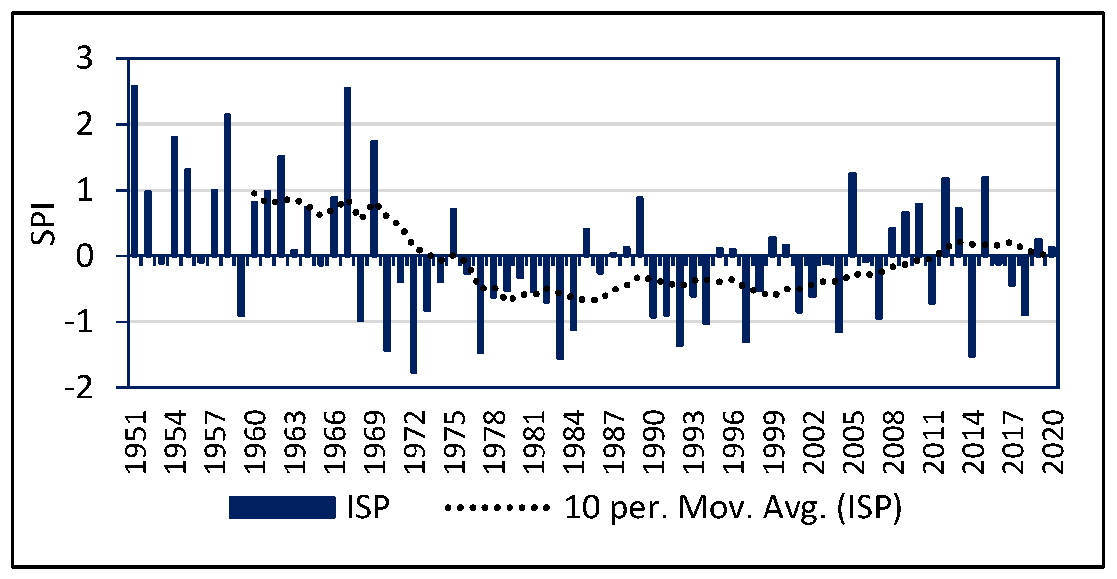
The trend since the 1950s shows that there has been a decrease in rainfall corresponding to the droughts of the 1970s and 1980s (figure 2). These dry phases occurred in Dakar until the 2010s. Indeed, it is only in the 2010s that an ascending phase is observed. Lately, the 2022 rainfall was exceptionally high with 800.6 mm recorded. Since 1967, such a quantity has not been observed in Dakar. That was the equivalent of a 50-year return period that was recorded in Dakar in 2022.
Figure 2. SPI from 1951 to 2020 in Dakar-Yoff.
Preprints 70050 g002
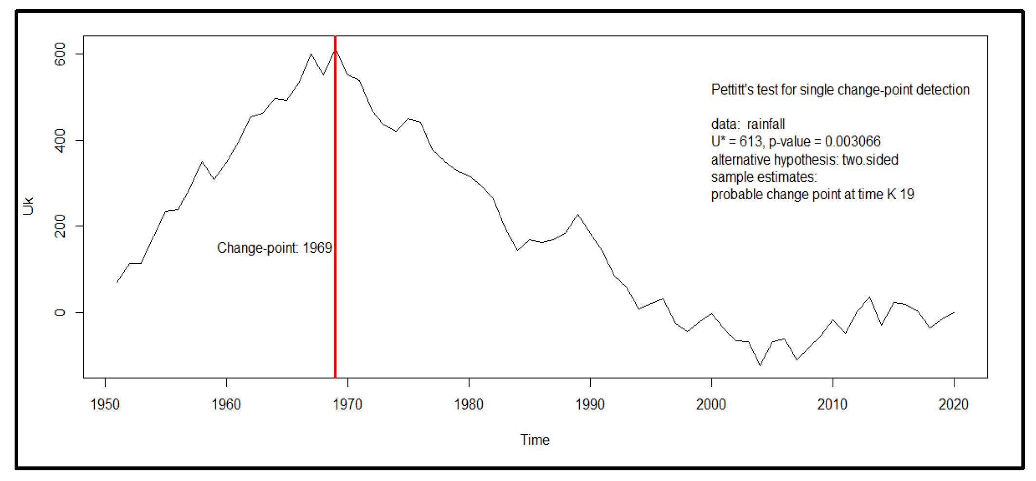
The 2022 rainfall is the first time that cumulative rainfall has exceeded the 1950-1970 average (the wettest decades from 1950 to the present) by 37%. Despite this increase, the last decade remains below the average of the pre-drought years. The 10-year moving average curve of the IPS is positive, but barely above zero. Thus, the break in the series remains in the 1960s. The Pettitt test gives 1969 as the year of the rainfall break (figure 3).
Figure 3. Pettitt test gives 1969 as the year of the rainfall break.
Preprints 70050 g003
The increase in precipitation in the 2010s has been insufficient to create a real break in the precipitation trend. Despite significant annual rainfall recorded in 2005, 2012, 2015 and 2022, below-average amounts have also been observed recently, such as in 2004, 2007, 2011, 2014 and 2018.
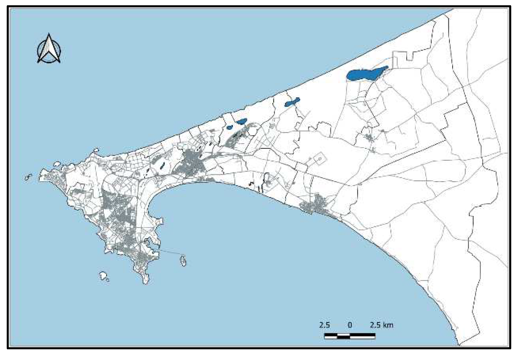
The Dakar region is dotted with water bodies from the northeast, with Lake Retba, to the Park located in Hann (Figure 4). Reflecting the topography, these low-lying areas are vulnerable to flooding. In addition, they are the final destination of runoff water that feeds the many temporary watercourses of Dakar.
Figure 4. Water bodies in the Dakar Region.
Preprints 70050 g004
Land use shows that the communes located along the water bodies are physically vulnerable due to topography and hydrography. Thus, the center of the region (departments of Keur Massar, Guédiawaye and Pikine) is ex-posed to temporary runoff.

3.3. Extreme rainfall and sanitation
The daily maximums are as variable as the annual rainfall (figure 5). They were higher in the period before the 1969 change-point. Indeed, they exceeded 150 mm twice (1962 and 1964). They were lower during the dry decades of the 1970s and 1980s. The highest maximum was only 114 mm (1989) during the below-average period. Most years during this dry period had below-average daily maximums (7l mm). The recovery of rainfall in the 1990s and 2000s resulted in higher daily maximums. For example, 144 mm was recorded in 1996 and 161 mm in 2012. The 2012 maximum was the highest, never observed since recording started at Dakar-Yoff in 1947.
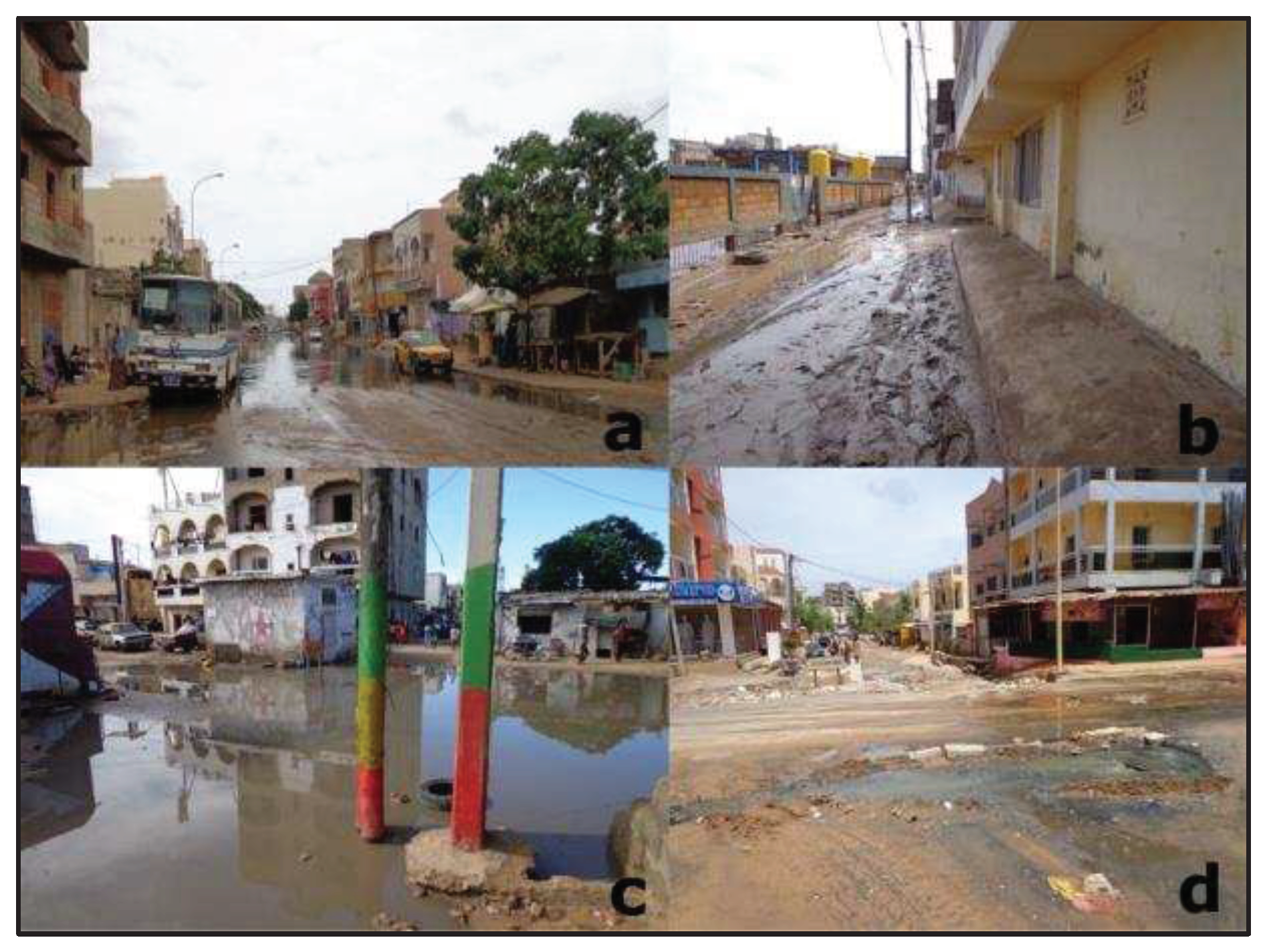
The recovery in precipitation corresponds to a high frequency of rainfall extremes. The correlation coefficient between the annual rainfall and the daily maximum is positive (0.6). Those extreme rains cause flooding and disrupt wastewater disposal. In fact, during the rainy season, malfunctions are noted in the wastewater drainage system. Such disruptions negatively affect the neighborhood because of the wastewater that mixes with the rainwater (illustration 1).
Illustration 1. Stagnant water in Dakar during the rainy season (C. Diop, a : juillet 2020, b, c, d : septembre 2019).
Preprints 70050 g006
In several neighborhoods of Dakar, both the communal drainage system, with the pipes and channels managed by the Office National de l'Assainissement du Sénégal, and the individual tanks are exposed to the influx of rainwater. Also, it is not uncommon to see stagnation of rainwater and wastewater.
Failures in the sewage disposal system pose a threat to the groundwater, the aesthetics and the health of city dwellers in the suburbs of Dakar. Rainwater, because of its intensity with extremes and successive days of rain, is another threat. During the rainy season, the impact of human interventions modifies the urban hydrology. Thus, extreme rains indirectly pose a sanitation and hygiene problem (through runoff and flooding).

4. Discussion

The current increase in rainfall in the Dakar region happens when ground water is not pumped anymore due to their pollution by domestic wastewater, as confirmed in the study by [45]. It poses not only a recurrent annual risk of flooding [47], but also public health risks through the development of diseases related to wastewater. Indeed, rainfall has increased by 41% compared to the 1970-2004 series. This increase in rainfall in the peninsula of Dakar has led to systematic flooding at many places in the city and its outskirts, simply because it is impossible for the rainwater to infiltrate the soil, which is soaked in dirty water. The wastewater from the 70% to 92% of the population that is not connected to the communal drainage network (table 1) and an estimated loss of 50% into the environment represent an annual volume of wastewater of the order of 50 to 25 million m3/year directly flowed into the soil. The contamination of the ground water, due to the inefficiency of individual sanitation solutions, has been highlighted in the suburbs of Dakar. [48] found nitrate concentrations of 497 mg/l in the water that feeds the groundwater table in Pikine. [48] found high nitrate levels in relation to wastewater. He spoke of chemical leaching of wastewater by rainwater. Using modelling for the suburbs of Dakar, Abidjan and Abomey-Calavi [49] showed that it would take 50 years for the nitrate concentration in the groundwater to exceed the World Health Organization limit value for drinking water (50 mg/l). Our analysis of precipitation shows that 1969 remains the most significant break despite the recovery of precipitation in the 1990s and 2000s. The 1960s break remains the most significant from the beginning of observations until 2018 [50]; [51]; [52]; [53]. Thus, as early as the 1990s, environmental problems related to rainwater and sanitation have been observed [48]. Heavy rainfall, however, dilutes water and reduces pollutant concentrations [48].
Extreme rainfall was recorded mostly in the above-average periods. [54] found high daily amounts, above 40 mm, associated with the increase in annual rainfall in the 2000s in the Sahel. This greater frequency of daily rainfall was observed in Senegal [55]; [56].
The losses constitute a valuable resource because they are water rich in organic matter that can be used for plant production, under certain conditions to be respected [23]. The idea of reusing them to produce plant biomass in peri-urban and urban areas is an integral part of the Smart Clean Garden concept (Orange et al., 2018) mobilizing the principles of ecohydrology.

5. Conclusion

The link between storm water management, wastewater management, urban planning in the city of Dakar and land management is obvious. But it is still relatively little or not taken into consideration. The challenge is to take charge of the development of urban areas, taking into account both storm water and wastewater. The latter concentrates organic contents of interest for soil fertility, but also pathogenic elements dangerous for human health. Extreme rains, as in 1996, 2000 and 2012 in Dakar with daily rainfall of more than 100 mm, favor flooding, but also stagnation of wastewater, as heavy rains disrupt the functioning of the drainage system and cause septic tanks to overflow. The low rate of the population connected to the sewage system (8%) makes it difficult to treat the wastewater before it is flowed into the environment. The 92% of the population using septic tanks represent a threat to a proper management of the environment of city.
Given the multiple issues at stake for health, the environment and the urban economy, it is urgent that planning policies integrate urban and peri-urban territories into a whole. Policies must consider at the same time residential areas, market gardening and green spaces, in order to build a "sponge city" capable of absorbing rainwater and wastewater, destroying their pathogenic components and mobilizing organic matters useful for green production (green spaces and market gardening).

References

  1. FAO, 2012. Growing greener cities in Africa. First status report on urban and peri-urban horticulture in Africa. FAO, Rome, 116 p. ISBN 978-92-5-107286-8.
  2. Breuste J, 2020. The Green City: General Concept. In: Breuste J., Artmann M., Ioja C., Qureshi S. (eds) Making Green Cities. Cities and Nature Springer, 527p. [CrossRef]
  3. Tellman B., Sullivan J. A., Kuhn C., Kettner A. J., Doyle C. S., Brakenridge G. R., Erickson T. A., & Slayback D. A., 2021. Satellite imaging reveals increased proportion of population exposed to floods. Nature, 596(7870), 80–86, doi :10.1038/s41586-021-03695-wTheys J, Emelianoff C, 2001. Les contradictions de la ville durable. Le Débat, 113(1), 122-135. [CrossRef]
  4. Caretta, M.A., A. Mukherji, M. Arfanuzzaman, R.A. Betts, A. Gelfan, Y. Hirabayashi, T.K. Lissner, J. Liu, E. Lopez Gunn, R. Morgan, S. Mwanga, and S. Supratid, 2022. Water. In: Climate Change 2022: Impacts, Adaptation and Vulnerability. Contribution of Working Group II to the Sixth Assessment Report of the Intergovernmental Panel on Climate Change [H.-O. Portner, D.C. Roberts, M. Tignor, E.S. Poloczanska, K. Mintenbeck, A. Alegria, M. Craig, S. Langsdorf, S. Loschke, V. Moller, A. Okem, B. Rama (eds.)]. Cambridge University Press, Cambridge, UK and New York, NY, USA, pp. 551–712. [CrossRef]
  5. Tramblay Y., Mimeau L., Vinet F. & Sauquet E., 2019. Detection and Attribution of Flood Trends in Mediterra-nean Basins. Hydrol. Earth Syst. Sci., 23, 4419–4431. [CrossRef]
  6. Andrade, L., O’Dwyer J., O’Neill E. & P. Hynds, 2018. Surface water flooding, groundwater contamination, and enteric disease in developed countries: a scoping review of connections and consequences. Environ. Pollut., 236, 540–549. [CrossRef]
  7. Huang L.-Y., Wang Y.-C., Wu C.-C., Chen Y.-C., Huang Y.-L., 2016. Risk of Flood-Related Diseases of Eyes, Skin and Gastrointestinal Tract in Taiwan: A Retrospective Cohort Study. PLoS ONE, 11(5): e0155166. [CrossRef]
  8. Paterson D.L., Wright H. and Harris P.N., 2018. Health risks of flood disasters. Clin. Infect. Dis., 67(9), 1450–1454. [CrossRef]
  9. Setty K.E., Enault J., Loret J.-F., Serra C. P., Martin-Alonso J., Bartram J., 2018, Time series study of weather, water quality, and acute gastroenteritis at water safety plan implementation sites in France and Spain. Int. J. Hyg. Environ. Health, 221(4), 714–726. [CrossRef]
  10. Eves, C. & S. Wilkinson, 2014. Assessing the immediate and short-term impact of flooding on residential property participant behaviour. Nat. Hazards, 71(3), 1519–1536. [CrossRef]
  11. Vernay A.L., Rahola T., Ravesteijn W., 2010. Growing food, feeling change: towards a holistic and dynamic approach of eco-city planning. In Ravesteijn W, Cooke P: Eco-city concepts and approaches, 3rd Int Conf on Next Generation Infrastructure Systems for Eco-Cities, Shenzhen, 10-13 nov2010.
  12. Kulinska E., Dendera-Gruszka M., 2019. Green cities, problems and solutions in Turkey. Transportation Research Procedia, 39, 242-251.
  13. Emelianoff, 2001. Pour une ville durable - https://www.cairn.info/revue-mouvements-2005-4-page-57.htm - DOI10.3917/mouv.041.0057 - pages 57 à 63.
  14. Wackernagel, M. and Rees, W. (1996) Our Ecological Footprint: Reducing Human Impact on the Earth. New Society Publishers, Low Carbon Economy, Vol.5 No.2, June 27, 2014 Wackernagel, M. and Rees, W. (1996) Our Ecological Footprint Reducing Human Impact on the Earth. New Society Publishers, Philadelphia. - References - Scientific Research Publishing (scirp.org).
  15. Luck M.A., Jenerette G.D., Wu J., Grimm N.B., 2001. The urban funnel model and the spatially heterogeneous ecological footprint. Ecosystems 4, 782–796. [CrossRef]
  16. Jepson E.J., Edwards M.M., 2005. How possible is sustainable urban development? An analysis of planer’s perceptions about new urbanism, smart growth and the ecological city. Plann. Practices & Research, 25(4), 417-437.
  17. Scott R, Scott P, Hawkins P, Blackett I, Cotton A, Lerebours, A, 2019. Integrating basic urban services for better sanitation outcomes. Sustainability, 11, 6706. [CrossRef]
  18. Breuste, 2020. Multifunctional Urban Green Spaces. [CrossRef]
  19. Sharifi M., Kawakubo S., Milovidova A., 2020. Urban sustainability assessment tools: toward integrating smart city indicators. In: Creating Sustainable Smart Cities in the Internet of Things Era, Ed. Urban Systems Design, Chapter 11, 345-372.
  20. PROGEP, 2012. PROGEP : Etude pour l’élaboration d’une stratégie nationale de planification et de gestion urbaine intégrées, prenant en compte la prévention des risques d’inondations et l’adaptation au changement climatique. Rapport diagnostic Phase 1, ADM, Dakar – Sénégal.
  21. Norman G., Scott P., Pedley S., 2011. The PAQPUD settled sewerage project (Dakar, Senegal): Problems arising, lessons learned. Habitat International, 35, 361-371.
  22. World Meteorological Organization (WMO), 2016, Handbook of Drought Indictors and Indices. WMO-No. 1173, Geneva, 45 p.
  23. Gaye M. 2011. Guide pratique pour la mise en place de systèmes sociaux alternatifs d’assainissement condominium en milieu urbain et périurbain. Rapport Technique, ENDA-Rup, Dakar, 177p, ISBN 92 9130 081 0.
  24. Coly P., Samb N-M., Gaye N., 2020. Le PROGEP : une solution durable dans la gestion des inondations en milieu urbain. Rapport Conclusion, ADM, Dakar, Senegal. 3 p.
  25. Leclercq R., 2017. The politics of risk policies in Dakar, Senegal. Int. J of Disasters Risk Reduction, 26, 93-100.
  26. ANSD (Agence Nationale de la Statistique et de la Démographie), 2016. Rapport projection de la population du Sénégal (2013-2063), ANSD, février 2016, 167 p.
  27. Guttman N.B., 1994. On the sensitivity of sample L moments to sample size. Journal of Climate, 7(6):1026–1029.
  28. Sailer R. A., Hayes M. & Bressan L., 2002, Using the Standard Precipitation Index for Flood Risk Monitoring, Int. J. Climatol., 22(11), pp. 1365-1376. [CrossRef]
  29. Ali A. & Label Th., 2008, The Sahelian Standardized rainfall index revisited, Int. J. Climatol. [CrossRef]
  30. Naresh Kumar M., Murthy C.S., Sesha Sai M.V.R. and Roy P.S., 2009, On the use of Standardized Precipitation Index (SPI) for drought intensity assessment, Met. Apps, 16: 381-389, Accessed 14 February 2023. [CrossRef]
  31. Du J., Fang J., Xu W. & Shi P., 2013, Analysis of dry/wet conditions using the standardized precipitation index and its potential usefulness for drought/flood monitoring in Hunan Province, China. Stoch Environ Res Risk Assess, 27, 377–387, Accessed 14 February 2023. [CrossRef]
  32. Mupepi O. & Matsa M. M., 2023, A combination of vegetation condition index, standardized precipitation index and human observation in monitoring spatio-temporal dynamics of drought. A case of Zvishavane District in Zimbabwe, Environmental Development 45 (2023) 100802, Published online 13 January 2023, Accessed 14 February 2023. [CrossRef]
  33. Zhang R., Bento V. A., Qi J., Xu F., Wu J., Qiu J., Li J., Shui W. & Wang Q., 2023, The first high spatial resolution multi-scale daily SPI and SPEI raster dataset for drought monitoring and evaluating over China from 1979 to 2018, Big Earth Data, published online 3 January 2023, Accessed 14 February 2023. [CrossRef]
  34. McKee, T.B., et al. (1993) The Relationship of Drought Frequency and Duration to Time Scales. 8th Conference on Applied Climatology, Anaheim, 17-22 January 1993, 6 p. Available online: http://clima1.cptec.inpe.br/~rclima1/pdf/paper_spi.pdf.
  35. R Core Team, 2022, R: A language and environment for statistical computing, R Foundation for Statistical Computing, R version 4.2.2, Vienna, Austria, URL. Available online: https://www.R-project.org/.
  36. Pohlert T., 2020, trend: Non-Parametric Trend Tests and Change-Point Detection_. R package version 1.1.4. Available online: https://CRAN.R-project.org/package=trend.
  37. Gning J.B., Diop C., Dongo K., Koné D., 2017. Facteurs déterminants le tarif de la vidange mécanique des matières de boues d’assainissement à Dakar. Int. J. Biol. Chem. Sci. 11(1), 313-332.
  38. Sall M., Vanclooster M., 2009. Assessing the well water pollution problem by nitrates in the small-scale farming systems of the Niayes region, Senegal. Agr. Water Management, 96, 1360-1368.
  39. Ba A, Cantoreggi N, Simos J, Duchemin E, 2016. Impacts sur la santé des pratiques des agriculteurs urbains à Dakar (Sénégal). VertigO, 16(1). [CrossRef]
  40. Chowdhry and Koné, 2012. Business Analysis of Fecal Sludge Management: Emptying and Transportation Services in Africa and Asia - Draft final report, 2-1662-chowdhury-2012-business.pdf (susana.org).
  41. Marfaing L., 2019. Dakar ville moderne : la médiation des entrepreneurs sénégalais en Chine. Canadian Journal of African Studies / Revue canadienne des études africaines, Routledge Ed., 53(1), 89-107.
  42. PSMBV, 2011, Programme de structuration du marché des boues de vidange, Programme de Structuration du Marché des Boues de Vidange (PSMBV) | 9th World Water Forum (dakar2021.sn).
  43. PNDDAA, 2018, Sénégal : LE PNDDAA, UN NOUVEAU PROGRAMME DESTINÉ À LA DÉMOCRATISATION DE L’ASSAINISSEMENT (lejecos.com).
  44. ONAS, 2018, Réduction des risques d’inondations : L’ONAS sur le terrain de l’anticipation aux Maristes et à Ouakam, Réduction des risques d’inondations : L’ONAS sur le terrain de l’anticipation aux Maristes et à Ouakam | OFFICE NATIONAL DE L'ASSAINISSEMENT DU SENEGAL (ONAS).
  45. Ndiaye M.L., Ndiaye E.H.A.D., Traore V.B., Diaw A.T., Beye A.C., 2016. Impacts of rainfall variability and urban sprawl on the environment and the population well-being at Ouakam Commune, Dakar, Senegal. Archives of Current Research International 6(2): 1-12; Article no. ACRI.30214 ISSN: 2454-7077.
  46. Collin J.J. et Salem G., 1989. Pollution des eaux souterraines par les nitrates dans les banlieues non assainies des pays en développement : le cas de Pikine (Sénégal), Texte de la communication proposée pour le Symposium international sur des solutions intégrées pour des problèmes de pollution de 1’eau (SISSIPA) – Lisbonne, 19-23 juin 1989, 12 p.
  47. BM, 2009. Rapport d’évaluation des besoins post catastrophes inondations urbaines à Dakar. Rapport Banque Mondiale. Available online: http://documents.worldbank.org/curated/en/844871468103494562/pdf/713340ESW0FREN00PU BLIC00 from0daniel.pdf.
  48. Bassel M., 1996. Eaux et environnement à Dakar - Pluies, ruissellement, pollution et évacuation des eaux. Contribution à l’étude des problèmes d’environnement liés aux eaux dans la région de Dakar. Thèse de doctorat de 3e cycle, Département de Géographie, Université Cheikh Anta Diop de Dakar, 244 p.
  49. Templeton M. R., Hammoud A. S., Adrian P. B., Braun L., Foucher J.-A., Grossmann J., Boukari M., Faye S. and Jourda J. P., 2015. Nitrate pollution of groundwater by pit latrines in developing countries, American Institute of Mathematical Sciences, Environmental Science, vol. 2, issue 2, pp. 302-313. [CrossRef]
  50. Sagna P., 1995. L’évolution pluviométrique récente de la Grande Côte du Sénégal et de l’Archipel du Cap-Vert, in Revue de géographie de Lyon, n° 3-4, pp. 187-192.
  51. Dacosta H., Konaté Y.K. et Malou R., 2002. La variabilité spatio-temporelle des précipitations au Sénégal depuis un siècle. In Regional hydrology: bringing the gap between reseach and pratice (FRIEND conference, Le Cap, South Africa), IAHS Publication n° 274, pp. 499–506.
  52. FAYE C., 2019. Changements climatiques observés sur le littoral sénégalais (région de Dakar) depuis 1960 : étude de la variabilité des tendances sur les températures et la pluviométrie, in Nature & Technology Journal, vol. C, Environmental Sciences, n° 20, pp. 65-78.
  53. Ndiaye M., Diop C. et Sagna P., 2020. Le maraîchage à Malika face à la variabilité climatique dans la région de Dakar (Sénégal), Revue de géographie du Laboratoire Leïdi « Dynamiques des territoires et développe-ment », n° 24, pp. 319-334.
  54. Descroix L., Diongue Niang A., Dacosta H., Panthou G., Quantin G. et Diedhiou A., 2013. Evolution des pluies de cumul élevé et recrudescence des crues depuis 1951 dans le bassin du Niger-Moyen (Sahel), Climatologie, Vol. 10, pp. 37-49.
  55. Diop C., Sagna P. et Sambou P. C., 2014. Vulnérabilité des populations urbaines face aux fortes pluies : L’exemple du Sénégal en 2012, Actes du XXVIIe colloque de l’Association Internationale de Climatologie, Climat : Système et interractions, 2-5 juillet 2014, Dijon (France), pp. 554-559.
  56. Diop C. et Sagna P., 2019. Évolution des précipitations journalières à cumul élevé de 1971 à 2018 au Sénégal, Géovision, hors-série n°1, Actes du colloque international de géographie « Dynamique des milieux anthropisés et gouvernance spatiale en Afrique subsaharienne depuis les indépendances », 11-13 juin 2019, Université Alassane Ouattara, Bouaké, Côte d’Ivoire, Tome 2, pp. 536-558.
  57. Orange D., Gérino M., Costa D.T., Stinckwich S., 2018. SmartCleanGarden concept : de multiples innovations pour gérer les eaux usées urbaines. IRD LeMag. Available online: https://lemag.ird.fr/fr/smart-clean-garden-concept-de-multiples-innovations-pour-gerer-les-eaux-usees-urbaines.
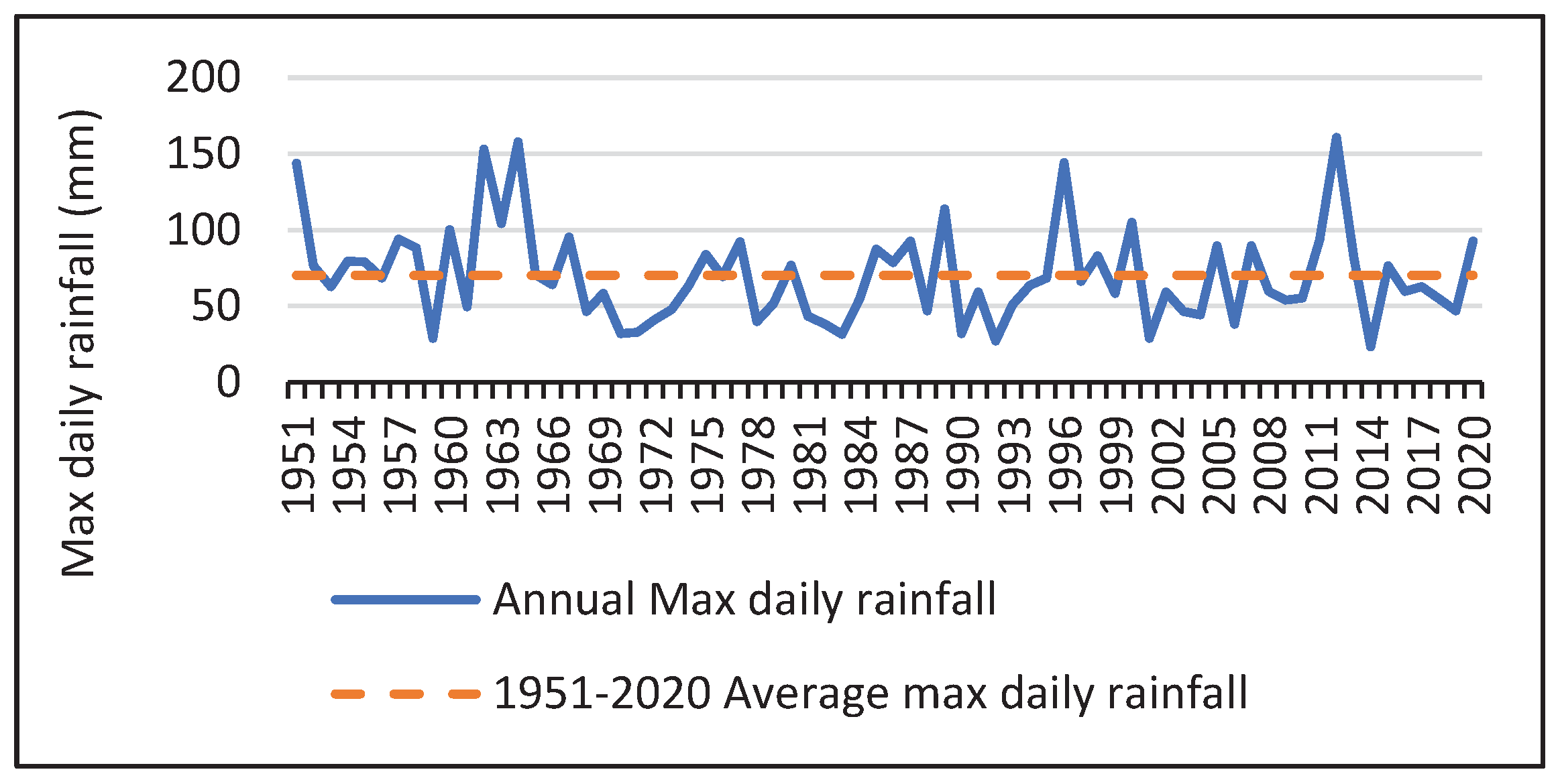
Figure 5. Maximums daily rainfall at Dakar-Yoff from 1951 à 2020.
Preprints 70050 g005
Table 1. Rainwater plant capacity in the departments of the Dakar region (Source: [43]) and estimates of the percentage of people actually connected to the drainage system.
Départements Name of the sewage plant Capacity (m3/day) Population (number) Area (km2) Density (in habitants/km2) m3/day per resident
for 30% connected
Estimation of citizens serviced by a sewage plant (%) Estimates of citizens serviced by a sewage plant
Dakar Cambérène 19,200 1,216,737 77.12 15,777 0.053 16 194677.92
Guédiawaye SHS 595 349,991 12.8 27,343 0.006 2 6999.82
Pikine Niayes 875 1,243,004 95 13,084 0.002 1 12430.04
Rufisque Rufisque 2,856 419,209 17.6 23,819 0.023 7 29344.63
Total or average 23,526 3,228,941 202.52 20,006 0.0020 8 243452.41
Disclaimer/Publisher’s Note: The statements, opinions and data contained in all publications are solely those of the individual author(s) and contributor(s) and not of MDPI and/or the editor(s). MDPI and/or the editor(s) disclaim responsibility for any injury to people or property resulting from any ideas, methods, instructions or products referred to in the content.
Copyright: This open access article is published under a Creative Commons CC BY 4.0 license, which permit the free download, distribution, and reuse, provided that the author and preprint are cited in any reuse.
Prerpints.org logo

Preprints.org is a free preprint server supported by MDPI in Basel, Switzerland.

Subscribe

© 2024 MDPI (Basel, Switzerland) unless otherwise stated