Submitted:
23 June 2023
Posted:
26 June 2023
You are already at the latest version
Abstract
Keywords:
1. Introduction
2. Material and Methods
2.1. Objectives
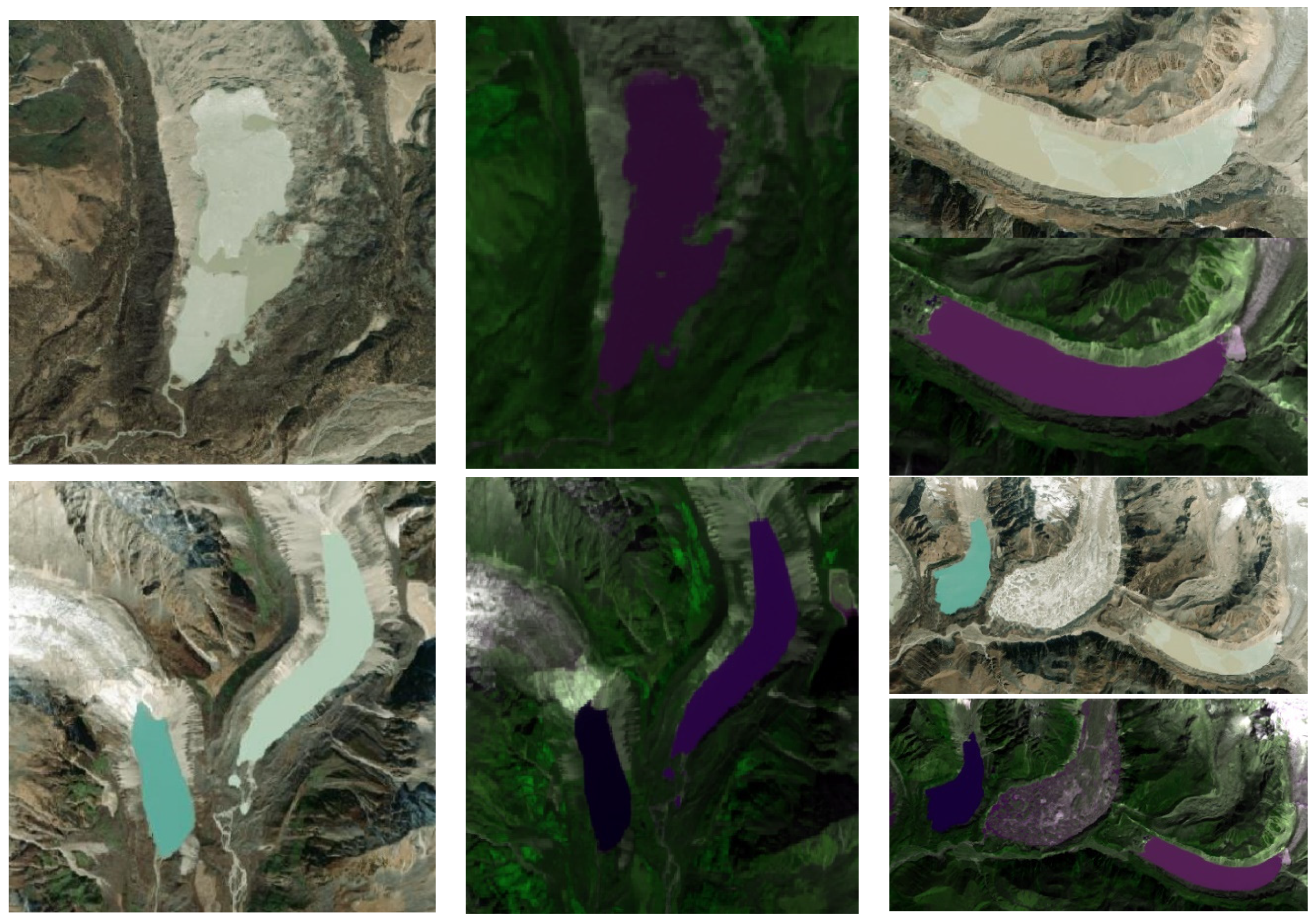
2.2. Study Area
2.3. Data Resources
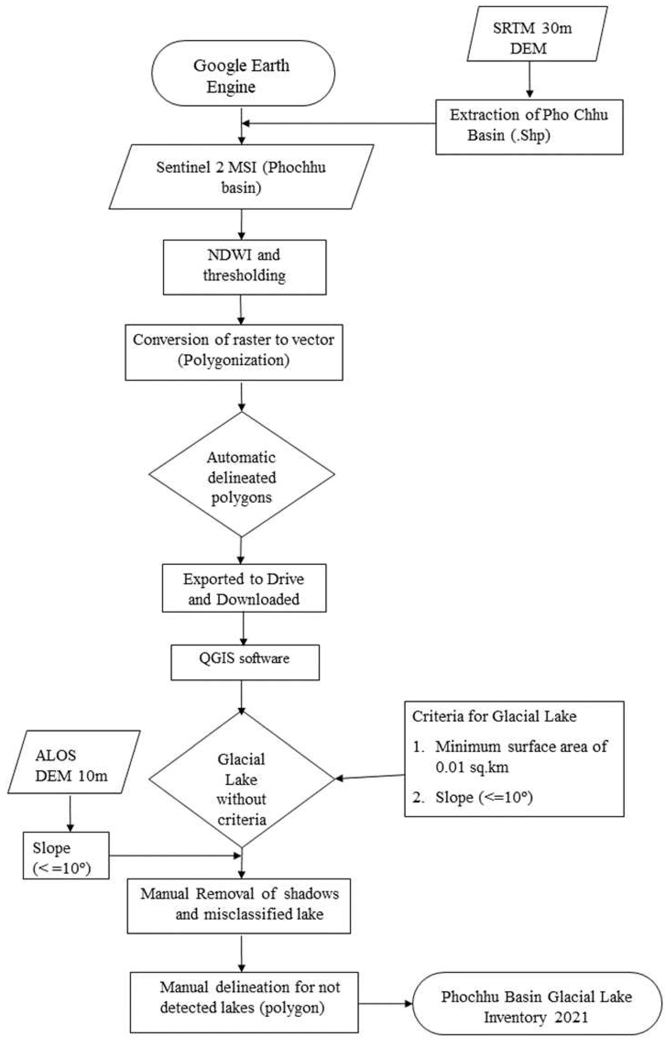
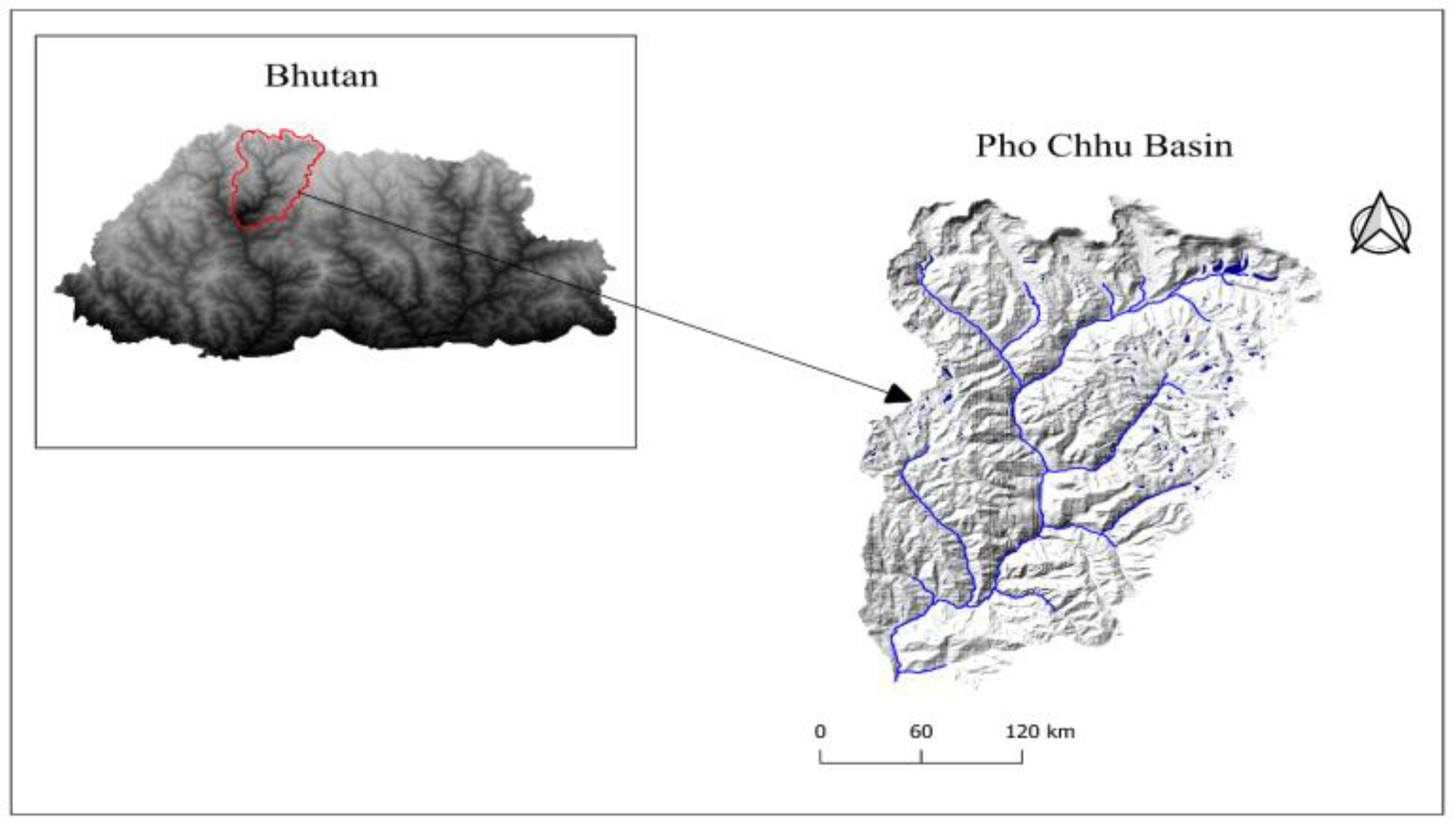
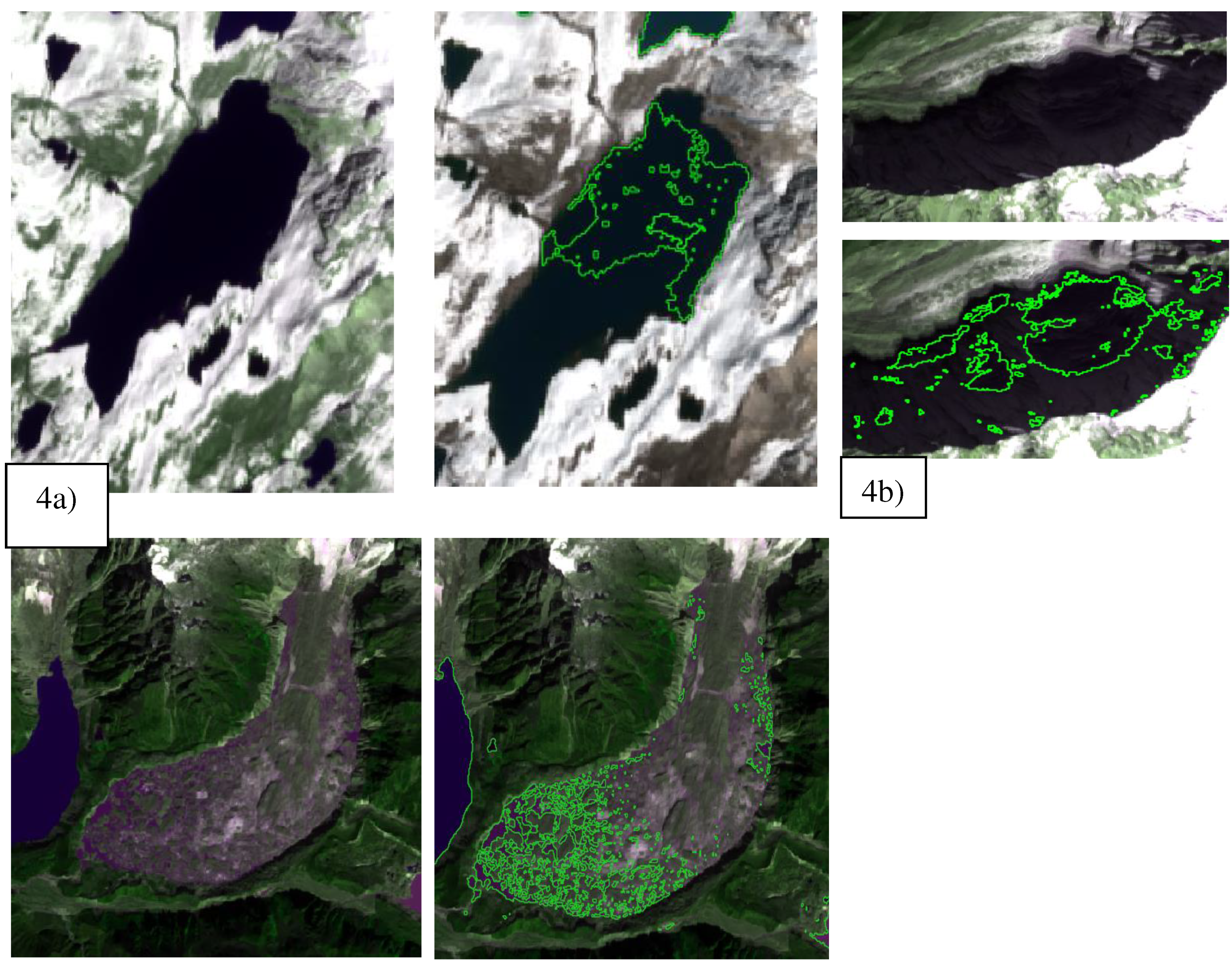
2.4. Methodology
3. Results
3.1. Hypsography
3.2. Discussions
3.3. Comparison with earlier inventory
4. Conclusions
Author Contributions
Funding
Data Availability Statement
Acknowledgments
Conflicts of Interest
Appendix A Phochhu Glacial Lake Inventory
|
Object _ID |
PGLI_ID | GLIMS_ID | Basin | Latitude | Longitude | Area (Km2) | Elevation (m.a.s.l) |
Local_ Name |
Image _Year |
| 1 | Pho_gl 70 | G090084E28069N | Phochhu | 28.06936 | 90.08410 | 0.090 | 4660.7330 | 2021 | |
| 2 | Pho_gl 69 | G090083E28077N | Phochhu | 28.07661 | 90.08325 | 0.070 | 4711.2170 | 2021 | |
| 3 | Pho_gl 68 | G090082E28082N | Phochhu | 28.08186 | 90.08153 | 0.036 | 4706.6381 | 2021 | |
| 4 | Pho_gl 62 | G090043E28096N | Phochhu | 28.09584 | 90.04284 | 0.064 | 5104.8016 | 2021 | |
| 5 | Pho_gl 61 | G090042E28092N | Phochhu | 28.09165 | 90.04164 | 0.089 | 5039.0335 | 2021 | |
| 6 | Pho_gl 66 | G090063E28092N | Phochhu | 28.09189 | 90.06346 | 0.023 | 4903.2414 | 2021 | |
| 7 | Pho_gl 67 | G090075E28088N | Phochhu | 28.08846 | 90.07520 | 0.023 | 4764.9234 | 2021 | |
| 8 | Pho_gl 17 | G089886E27923N | Phochhu | 27.92267 | 89.88593 | 0.063 | 4841.1497 | 2021 | |
| 9 | Pho_gl 18 | G089891E27925N | Phochhu | 27.92526 | 89.89148 | 0.032 | 4874.4438 | 2021 | |
| 10 | Pho_gl 21 | G089883E27931N | Phochhu | 27.93065 | 89.88337 | 0.018 | 4935.2167 | 2021 | |
| 11 | Pho_gl 19 | G089900E27929N | Phochhu | 27.92933 | 89.90026 | 0.227 | 4945.0899 | 2021 | |
| 12 | Pho_gl 24 | G089906E27941N | Phochhu | 27.94106 | 89.90605 | 0.135 | 5029.0532 | 2021 | |
| 13 | Pho_gl 27 | G089923E27948N | Phochhu | 27.94826 | 89.92341 | 0.018 | 5071.5389 | 2021 | |
| 14 | Pho_gl 26 | G089910E27948N | Phochhu | 27.94785 | 89.91006 | 0.017 | 5079.7225 | 2021 | |
| 15 | Pho_gl 12 | G089898E27904N | Phochhu | 27.90401 | 89.89812 | 0.118 | 4784.0404 | 2021 | |
| 16 | Pho_gl 8 | G089885E27896N | Phochhu | 27.89601 | 89.88461 | 0.112 | 4563.9039 | 2021 | |
| 17 | Pho_gl 14 | G089897E27909N | Phochhu | 27.90939 | 89.89733 | 0.061 | 4868.7374 | 2021 | |
| 18 | Pho_gl 16 | G089861E27915N | Phochhu | 27.91480 | 89.86114 | 0.078 | 4742.5543 | 2021 | |
| 19 | Pho_gl 5 | G089846E27880N | Phochhu | 27.87968 | 89.84642 | 0.073 | 4584.6740 | 2021 | |
| 20 | Pho_gl 4 | G089845E27877N | Phochhu | 27.87722 | 89.84464 | 0.061 | 4587.1431 | 2021 | |
| 21 | Pho_gl 3 | G089843E27870N | Phochhu | 27.87034 | 89.84255 | 0.214 | 4505.5084 | 2021 | |
| 22 | Pho_gl 2 | G089835E27866N | Phochhu | 27.86554 | 89.83464 | 0.041 | 4555.4504 | 2021 | |
| 23 | Pho_gl 7 | G089856E27897N | Phochhu | 27.89731 | 89.85630 | 0.025 | 4574.9224 | 2021 | |
| 24 | Pho_gl 11 | G089866E27903N | Phochhu | 27.90256 | 89.86648 | 0.028 | 4573.3249 | 2021 | |
| 25 | Pho_gl 13 | G089862E27909N | Phochhu | 27.90861 | 89.86173 | 0.046 | 4687.1247 | 2021 | |
| 26 | Pho_gl 15 | G089872E27910N | Phochhu | 27.90972 | 89.87166 | 0.017 | 4741.1617 | 2021 | |
| 27 | Pho_gl 10 | G089946E27897N | Phochhu | 27.89654 | 89.94557 | 0.079 | 4860.8232 | 2021 | |
| 28 | Pho_gl 9 | G089943E27893N | Phochhu | 27.89290 | 89.94280 | 0.085 | 4845.9766 | 2021 | |
| 29 | Pho_gl 22 | G089922E27933N | Phochhu | 27.93331 | 89.92209 | 0.020 | 4978.0503 | 2021 | |
| 30 | Pho_gl 44 | G089887E28097N | Phochhu | 28.09692 | 89.88690 | 0.030 | 4739.2259 | 2021 | |
| 31 | Pho_gl 51 | G089934E28139N | Phochhu | 28.13936 | 89.93370 | 0.035 | 5069.8736 | 2021 | |
| 32 | Pho_gl 97 | G090310E28072N | Phochhu | 28.07196 | 90.31040 | 0.055 | 5042.1324 | 2021 | |
| 33 | Pho_gl 91 | G090232E28066N | Phochhu | 28.06621 | 90.23161 | 0.115 | 4728.6070 | 2021 | |
| 34 | Pho_gl 102 | G090249E28057N | Phochhu | 28.05733 | 90.24939 | 0.081 | 5128.3918 | 2021 | |
| 35 | Pho_gl 115 | G090234E27997N | Phochhu | 27.99727 | 90.23355 | 0.112 | 4978.4924 | 2021 | |
| 36 | Pho_gl 129 | G090222E27995N | Phochhu | 27.99545 | 90.22206 | 0.213 | 4934.2824 | 2021 | |
| 37 | Pho_gl 130 | G090216E27992N | Phochhu | 27.99203 | 90.21579 | 0.173 | 4934.4375 | 2021 | |
| 38 | Pho_gl 90 | G090211E28016N | Phochhu | 28.01611 | 90.21059 | 0.546 | 5128.7748 | Tsho Chena | 2021 |
| 39 | Pho_gl 89 | G090187E28012N | Phochhu | 28.01163 | 90.18683 | 0.208 | 5141.4725 | 2021 | |
| 40 | Pho_gl 88 | G090179E28023N | Phochhu | 28.02280 | 90.17934 | 0.162 | 5074.1911 | 2021 | |
| 41 | Pho_gl 80 | G090147E27964N | Phochhu | 27.96425 | 90.14673 | 0.219 | 4880.4836 | 2021 | |
| 42 | Pho_gl 150 | G090174E27901N | Phochhu | 27.90053 | 90.17374 | 0.487 | 4674.6552 | 2021 | |
| 43 | Pho_gl 149 | G090219E27893N | Phochhu | 27.89336 | 90.21891 | 0.162 | 4973.8740 | 2021 | |
| 44 | Pho_gl 159 | G090157E27829N | Phochhu | 27.82900 | 90.15708 | 0.234 | 4429.4764 | 2021 | |
| 45 | Pho_gl 155 | G090191E27850N | Phochhu | 27.85041 | 90.19132 | 0.232 | 4763.6804 | 2021 | |
| 46 | Pho_gl 158 | G090222E27827N | Phochhu | 27.82736 | 90.22180 | 0.293 | 4658.7205 | 2021 | |
| 47 | Pho_gl 154 | G090191E27857N | Phochhu | 27.85700 | 90.19133 | 0.160 | 4722.0031 | 2021 | |
| 48 | Pho_gl 152 | G090185E27878N | Phochhu | 27.87765 | 90.18535 | 0.146 | 4824.0541 | 2021 | |
| 49 | Pho_gl 151 | G090179E27877N | Phochhu | 27.87736 | 90.17858 | 0.094 | 4838.5798 | 2021 | |
| 50 | Pho_gl 145 | G090254E27863N | Phochhu | 27.86275 | 90.25391 | 0.071 | 4946.2053 | 2021 | |
| 51 | Pho_gl 157 | G090216E27845N | Phochhu | 27.84508 | 90.21596 | 0.065 | 4799.7703 | 2021 | |
| 52 | Pho_gl 156 | G090213E27850N | Phochhu | 27.84990 | 90.21267 | 0.095 | 4852.7941 | 2021 | |
| 53 | Pho_gl 164 | G090190E27942N | Phochhu | 27.94156 | 90.18973 | 0.163 | 4622.3388 | 2021 | |
| 54 | Pho_gl 146 | G090209E27932N | Phochhu | 27.93186 | 90.20925 | 0.116 | 4985.8593 | 2021 | |
| 55 | Pho_gl 140 | G090226E27961N | Phochhu | 27.96071 | 90.22613 | 0.051 | 5047.0098 | 2021 | |
| 56 | Pho_gl 78 | G090139E28002N | Phochhu | 28.00242 | 90.13903 | 0.151 | 5056.8298 | 2021 | |
| 57 | Pho_gl 76 | G090131E27988N | Phochhu | 27.98782 | 90.13056 | 0.195 | 5032.7758 | 2021 | |
| 58 | Pho_gl 83 | G090149E27986N | Phochhu | 27.98554 | 90.14934 | 0.165 | 4903.7797 | 2021 | |
| 59 | Pho_gl 79 | G090142E27992N | Phochhu | 27.99163 | 90.14224 | 0.092 | 4970.9389 | 2021 | |
| 60 | Pho_gl 77 | G090139E28007N | Phochhu | 28.00666 | 90.13917 | 0.088 | 5047.9245 | 2021 | |
| 61 | Pho_gl 84 | G090150E28004N | Phochhu | 28.00401 | 90.15006 | 0.135 | 5000.7430 | 2021 | |
| 62 | Pho_gl 32 | G089928E28008N | Phochhu | 28.00806 | 89.92816 | 0.033 | 5030.6798 | 2021 | |
| 63 | Pho_gl 33 | G089893E28030N | Phochhu | 28.02963 | 89.89327 | 0.104 | 5029.1856 | 2021 | |
| 64 | Pho_gl 34 | G089895E28036N | Phochhu | 28.03561 | 89.89454 | 0.055 | 5188.2178 | 2021 | |
| 65 | Pho_gl 35 | G089901E28038N | Phochhu | 28.03776 | 89.90051 | 0.037 | 5208.0676 | 2021 | |
| 66 | Pho_gl 43 | G089871E28059N | Phochhu | 28.05943 | 89.87113 | 0.035 | 5117.5788 | 2021 | |
| 67 | Pho_gl 37 | G089900E28047N | Phochhu | 28.04705 | 89.90027 | 0.045 | 5007.4079 | 2021 | |
| 68 | Pho_gl 38 | G089889E28061N | Phochhu | 28.06076 | 89.88922 | 0.026 | 4895.5057 | 2021 | |
| 69 | Pho_gl 39 | G089892E28064N | Phochhu | 28.06436 | 89.89228 | 0.027 | 4854.1798 | 2021 | |
| 70 | Pho_gl 81 | G090150E27957N | Phochhu | 27.95679 | 90.15011 | 0.055 | 4818.6933 | 2021 | |
| 71 | Pho_gl 82 | G090155E27939N | Phochhu | 27.93929 | 90.15491 | 0.077 | 4504.9961 | 2021 | |
| 72 | Pho_gl 36 | G090029E28013N | Phochhu | 28.01287 | 90.02947 | 0.037 | 4417.0276 | 2021 | |
| 73 | Pho_gl 63 | G090078E27954N | Phochhu | 27.95445 | 90.07845 | 0.084 | 4769.3636 | 2021 | |
| 74 | Pho_gl 64 | G090091E27931N | Phochhu | 27.93112 | 90.09062 | 0.145 | 4515.7660 | 2021 | |
| 75 | Pho_gl 65 | G090095E27942N | Phochhu | 27.94158 | 90.09522 | 0.096 | 4633.6293 | 2021 | |
| 76 | Pho_gl 31 | G089956E28005N | Phochhu | 28.00531 | 89.95574 | 0.117 | 4606.2117 | 2021 | |
| 77 | Pho_gl 6 | G089840E27888N | Phochhu | 27.88762 | 89.84028 | 0.032 | 4656.9502 | 2021 | |
| 78 | Pho_gl 114 | G090231E28005N | Phochhu | 28.00547 | 90.23145 | 0.049 | 5067.9616 | 2021 | |
| 79 | Pho_gl 87 | G090161E28010N | Phochhu | 28.01001 | 90.16127 | 0.078 | 5044.1990 | 2021 | |
| 80 | Pho_gl 1 | G089926E27864N | Phochhu | 27.86385 | 89.92625 | 0.351 | 4522.7971 | 2021 | |
| 81 | Pho_gl 116 | G089933E27908N | Phochhu | 27.90785 | 89.93339 | 0.037 | 4839.1771 | 2021 | |
| 82 | Pho_gl 94 | G090270E28106N | Phochhu | 28.10628 | 90.26953 | 3.615 | 4450.1922 | Thorthomi | 2021 |
| 83 | Pho_gl 52 | G089896E28146N | Phochhu | 28.14567 | 89.89644 | 0.037 | 5107.0987 | 2021 | |
| 84 | Pho_gl 45 | G089899E28106N | Phochhu | 28.10593 | 89.89863 | 0.236 | 4265.4842 | 2021 | |
| 85 | Pho_gl 46 | G089909E28114N | Phochhu | 28.11396 | 89.90935 | 0.449 | 4338.2057 | 2021 | |
| 86 | Pho_gl 165 | G089925E27951N | Phochhu | 27.95123 | 89.92478 | 0.039 | 5063.2564 | 2021 | |
| 87 | Pho_gl 50 | G089924E28131N | Phochhu | 28.13063 | 89.92431 | 0.032 | 5065.6486 | 2021 | |
| 88 | Pho_gl 30 | G089930E27973N | Phochhu | 27.97336 | 89.93019 | 0.628 | 5071.8259 | 2021 | |
| 89 | Pho_gl 48 | G089925E28119N | Phochhu | 28.11899 | 89.92485 | 0.030 | 4612.7993 | 2021 | |
| 90 | Pho_gl 25 | G089930E27941N | Phochhu | 27.94117 | 89.92996 | 0.705 | 4996.6530 | 2021 | |
| 91 | Pho_gl 29 | G089931E27965N | Phochhu | 27.96455 | 89.93136 | 0.022 | 5125.7897 | 2021 | |
| 92 | Pho_gl 20 | G089933E27924N | Phochhu | 27.92368 | 89.93307 | 0.064 | 4824.0174 | 2021 | |
| 93 | Pho_gl 28 | G089933E27950N | Phochhu | 27.95009 | 89.93305 | 0.063 | 5035.0823 | 2021 | |
| 94 | Pho_gl 23 | G089936E27932N | Phochhu | 27.93189 | 89.93619 | 0.018 | 4922.5932 | 2021 | |
| 95 | Pho_gl 49 | G089945E28124N | Phochhu | 28.12398 | 89.94491 | 0.057 | 4747.0541 | 2021 | |
| 96 | Pho_gl 40 | G089946E28078N | Phochhu | 28.07848 | 89.94623 | 0.033 | 4697.1487 | 2021 | |
| 97 | Pho_gl 42 | G089956E28091N | Phochhu | 28.09080 | 89.95550 | 0.021 | 4925.1274 | 2021 | |
| 98 | Pho_gl 53 | G089985E28104N | Phochhu | 28.10441 | 89.98488 | 0.027 | 5020.7684 | 2021 | |
| 99 | Pho_gl 41 | G089990E28085N | Phochhu | 28.08485 | 89.98979 | 0.019 | 5005.4663 | 2021 | |
| 100 | Pho_gl 55 | G090012E28108N | Phochhu | 28.10753 | 90.01158 | 0.017 | 4577.3046 | 2021 | |
| 101 | Pho_gl 58 | G090030E28060N | Phochhu | 28.06045 | 90.02952 | 0.061 | 4380.6264 | 2021 | |
| 102 | Pho_gl 57 | G090030E28070N | Phochhu | 28.07012 | 90.02979 | 0.027 | 4389.5129 | 2021 | |
| 103 | Pho_gl 59 | G090035E28057N | Phochhu | 28.05714 | 90.03528 | 0.051 | 4366.5529 | 2021 | |
| 104 | Pho_gl 60 | G090035E28042N | Phochhu | 28.04226 | 90.03458 | 0.025 | 4328.8780 | 2021 | |
| 105 | Pho_gl 56 | G090028E28113N | Phochhu | 28.11293 | 90.02765 | 0.373 | 4684.1453 | 2021 | |
| 106 | Pho_gl 72 | G090106E28007N | Phochhu | 28.00738 | 90.10642 | 0.085 | 4529.2313 | 2021 | |
| 107 | Pho_gl 73 | G090113E28084N | Phochhu | 28.08445 | 90.11311 | 0.081 | 4132.4213 | 2021 | |
| 108 | Pho_gl 74 | G090115E27969N | Phochhu | 27.96874 | 90.11520 | 0.063 | 4986.5692 | 2021 | |
| 109 | Pho_gl 75 | G090119E27964N | Phochhu | 27.96372 | 90.11919 | 0.031 | 4872.5197 | 2021 | |
| 110 | Pho_gl 86 | G090167E28090N | Phochhu | 28.09050 | 90.16700 | 0.046 | 4212.6409 | 2021 | |
| 111 | Pho_gl 85 | G090167E28098N | Phochhu | 28.09825 | 90.16687 | 0.024 | 4259.4520 | 2021 | |
| 112 | Pho_gl 147 | G090209E27917N | Phochhu | 27.91700 | 90.20934 | 0.070 | 4895.4657 | 2021 | |
| 113 | Pho_gl 153 | G090207E27876N | Phochhu | 27.87590 | 90.20712 | 0.395 | 4908.4793 | 2021 | |
| 114 | Pho_gl 148 | G090207E27902N | Phochhu | 27.90230 | 90.20723 | 0.018 | 4948.8182 | 2021 | |
| 115 | Pho_gl 166 | G090211E27970N | Phochhu | 27.97011 | 90.21055 | 0.058 | 4894.8130 | 2021 | |
| 116 | Pho_gl 131 | G090233E27978N | Phochhu | 27.97804 | 90.23284 | 0.684 | 5071.3220 | 2021 | |
| 117 | Pho_gl 132 | G090240E27953N | Phochhu | 27.95308 | 90.23970 | 0.035 | 5126.1570 | 2021 | |
| 118 | Pho_gl 139 | G090244E27915N | Phochhu | 27.91534 | 90.24391 | 0.227 | 5152.1527 | 2021 | |
| 119 | Pho_gl 133 | G090244E27940N | Phochhu | 27.94049 | 90.24409 | 0.019 | 5101.2487 | 2021 | |
| 120 | Pho_gl 126 | G090245E27954N | Phochhu | 27.95394 | 90.24546 | 0.027 | 5143.0296 | 2021 | |
| 121 | Pho_gl 138 | G090244E27922N | Phochhu | 27.92245 | 90.24389 | 0.046 | 5106.5043 | 2021 | |
| 122 | Pho_gl 117 | G090245E27983N | Phochhu | 27.98271 | 90.24467 | 0.175 | 5086.7060 | 2021 | |
| 123 | Pho_gl 125 | G090245E27956N | Phochhu | 27.95642 | 90.24465 | 0.096 | 5138.5371 | 2021 | |
| 124 | Pho_gl 160 | G090246E27848N | Phochhu | 27.84798 | 90.24605 | 0.092 | 4794.2659 | 2021 | |
| 125 | Pho_gl 128 | G090249E27938N | Phochhu | 27.93848 | 90.24861 | 0.024 | 5110.2017 | 2021 | |
| 126 | Pho_gl 127 | G090249E27941N | Phochhu | 27.94099 | 90.24922 | 0.016 | 5131.7925 | 2021 | |
| 127 | Pho_gl 93 | G090247E28107N | Phochhu | 28.10705 | 90.24734 | 1.311 | 4369.6644 | Rapstreng | 2021 |
| 128 | Pho_gl 163 | G090253E27841N | Phochhu | 27.84140 | 90.25301 | 0.080 | 4987.1665 | 2021 | |
| 129 | Pho_gl 141 | G090252E27897N | Phochhu | 27.89707 | 90.25218 | 0.084 | 5153.7910 | 2021 | |
| 130 | Pho_gl 120 | G090252E27960N | Phochhu | 27.95973 | 90.25164 | 0.023 | 5174.0302 | 2021 | |
| 131 | Pho_gl 161 | G090255E27847N | Phochhu | 27.84665 | 90.25489 | 0.027 | 4862.5148 | 2021 | |
| 132 | Pho_gl 121 | G090253E27956N | Phochhu | 27.95636 | 90.25284 | 0.021 | 5172.7406 | 2021 | |
| 133 | Pho_gl 134 | G090259E27925N | Phochhu | 27.92538 | 90.25896 | 0.112 | 5120.0668 | 2021 | |
| 134 | Pho_gl 123 | G090255E27953N | Phochhu | 27.95289 | 90.25531 | 0.148 | 5208.4491 | 2021 | |
| 135 | Pho_gl 124 | G090257E27943N | Phochhu | 27.94276 | 90.25671 | 0.058 | 5198.3799 | 2021 | |
| 136 | Pho_gl 162 | G090259E27843N | Phochhu | 27.84346 | 90.25861 | 0.073 | 5017.6680 | 2021 | |
| 137 | Pho_gl 119 | G090259E27957N | Phochhu | 27.95699 | 90.25913 | 0.019 | 5197.4656 | 2021 | |
| 138 | Pho_gl 112 | G090261E27996N | Phochhu | 27.99603 | 90.26113 | 0.167 | 5157.2726 | 2021 | |
| 139 | Pho_gl 118 | G090260E27964N | Phochhu | 27.96414 | 90.26003 | 0.470 | 5208.6979 | 2021 | |
| 140 | Pho_gl 101 | G090263E28059N | Phochhu | 28.05880 | 90.26306 | 0.066 | 5111.7751 | 2021 | |
| 141 | Pho_gl 135 | G090263E27920N | Phochhu | 27.91987 | 90.26252 | 0.229 | 5139.3498 | 2021 | |
| 142 | Pho_gl 113 | G090263E27988N | Phochhu | 27.98796 | 90.26333 | 0.077 | 5200.6541 | 2021 | |
| 143 | Pho_gl 106 | G090271E28029N | Phochhu | 28.02897 | 90.27058 | 0.219 | 5201.6249 | 2021 | |
| 144 | Pho_gl 108 | G090277E28008N | Phochhu | 28.00838 | 90.27694 | 0.100 | 5281.4415 | 2021 | |
| 145 | Pho_gl 100 | G090280E28050N | Phochhu | 28.04961 | 90.27962 | 0.045 | 5056.4580 | 2021 | |
| 146 | Pho_gl 107 | G090280E28013N | Phochhu | 28.01288 | 90.27980 | 0.153 | 5283.3743 | 2021 | |
| 147 | Pho_gl 109 | G090288E27997N | Phochhu | 27.99657 | 90.28835 | 0.426 | 5326.1661 | 2021 | |
| 148 | Pho_gl 95 | G090302E28093N | Phochhu | 28.09280 | 90.30161 | 1.528 | 4509.6434 | Luggye | 2021 |
| 149 | Pho_gl 104 | G090295E28030N | Phochhu | 28.03021 | 90.29470 | 0.070 | 5339.5863 | 2021 | |
| 150 | Pho_gl 105 | G090297E28027N | Phochhu | 28.02729 | 90.29672 | 0.020 | 5380.4000 | 2021 | |
| 151 | Pho_gl 110 | G090299E27993N | Phochhu | 27.99257 | 90.29949 | 0.120 | 5359.3877 | 2021 | |
| 152 | Pho_gl 111 | G090300E27989N | Phochhu | 27.98944 | 90.30030 | 0.015 | 5389.6118 | 2021 | |
| 153 | Pho_gl 103 | G090301E28029N | Phochhu | 28.02902 | 90.30106 | 0.043 | 5363.6019 | 2021 | |
| 154 | Pho_gl 99 | G090308E28043N | Phochhu | 28.04305 | 90.30834 | 0.017 | 5271.1628 | 2021 | |
| 155 | Pho_gl 98 | G090313E28059N | Phochhu | 28.05944 | 90.31339 | 0.076 | 5098.1631 | 2021 | |
| 156 | Pho_gl 96 | G090328E28086N | Phochhu | 28.08567 | 90.32751 | 0.045 | 4703.1031 | Drukchung | 2021 |
| 157 | Pho_gl 92 | G090231E28103N | Phochhu | 28.10344 | 90.23080 | 0.420 | 4345.5958 | Bechung | 2021 |
| 158 | Pho_gl 144 | G090238E27891N | Phochhu | 27.89129 | 90.23759 | 0.039 | 5009.9924 | 2021 | |
| 159 | Pho_gl 143 | G090243E27897N | Phochhu | 27.89703 | 90.24284 | 0.023 | 5145.8363 | 2021 | |
| 160 | Pho_gl 142 | G090241E27899N | Phochhu | 27.89909 | 90.24129 | 0.017 | 5169.9551 | 2021 | |
| 161 | Pho_gl 137 | G090255E27916N | Phochhu | 27.91611 | 90.25481 | 0.014 | 5198.9343 | 2021 | |
| 162 | Pho_gl 136 | G090257E27918N | Phochhu | 27.91842 | 90.25714 | 0.018 | 5189.4270 | 2021 | |
| 163 | Pho_gl 39 | G089978E28056N | Phochhu | 28.05626 | 89.97796 | 0.030 | 4990.0199 | 2021 | |
| 164 | Pho_gl 71 | G090089E28116N | Phochhu | 28.11593 | 90.08895 | 0.033 | 4491.4260 | 2021 | |
| 165 | Pho_gl 54 | G090011E28123N | Phochhu | 28.12270 | 90.01102 | 0.010 | 4703.4857 | 2021 | |
| 166 | Pho_gl 47 | G089955E28104N | Phochhu | 28.10429 | 89.95484 | 0.017 | 5133.7529 | 2021 |
References
- Bajracharya, S.R.; Maharjan, S.B.; Shrestha, F.; Sherpa, T.C.; Wagle, N.; Shrestha, A.B. (2020). Inventory of glacial lakes and identification of potentially dangerous glacial lakes in the Koshi, Gandaki, and Karnali river basins of Nepal, the Tibet Autonomous Region of China, and India. International Centre for Integrated Mountain Development and United Nations Development Programme.
- Global warming triggers glacial lakes flood threat. (2002, April 17). The United Nations. Retrieved January 3, 2022. Available online: https://www.un.org/press/en/2002/envdev634.doc.
- Gyeltsen, N.; Wangdi, P. (2021, September 4). Climate change casts shadow on Bhutan with glacial lakes at risk. NikkeiAsia. Available online: https://asia.nikkei.com/Spotlight/Environment/Climate-Change/Climate-change-casts-shadow-on-Bhutan-with-glacial-lakes-at-risk.
- Karma Yangzom, D.; Duba, T.; Namgay, W.; Lhamo, S.; Tshering, P.; Tashi, T.; Namgay, T. (2021). Bhutan Glacial Lake Inventory (BGLI). National Center for Hydrology and Meteorology.
- Khadka, N.; Zhang, G.; Thakuri, S. (2018, November 29). Glacial Lakes in the Nepal Himalaya: Inventory and Decadal Dynamics (1977–2017). Remote Sensing. Available online: https://www.mdpi.com/2072-4292/10/12/1913/pdf#:~:text=The%20mapping%20of%20glacial%20lakes,calculated%20to%20be%20~0.05%20km2.
- Mool, P. K.; Wangda, D.; Bajracharya, S.R.; Kunzang, K.; Gurung, D.R.; Joshi, S.P. Chapter 8: The Inventory of Glacial Lakes. In Inventory of Glaciers, Glacial Lakes, and Glacial Lake Outburst Floods: Monitoring and Early Warning Systems in the Hindu Kush-Himalayan Region, Bhutan; International Centre for Integrated Mountain Development, Mountain Environment and Natural Resources' Information Systems, 2002; pp. 65–80. [Google Scholar]
- Wangchuk, S.; Bolch, T. (2020, July 29). Mapping of glacial lakes using Sentinel-1 and Sentinel-2 data and a random forest classifier: Strengths and challenges. Science of Remote Sensing. [CrossRef]
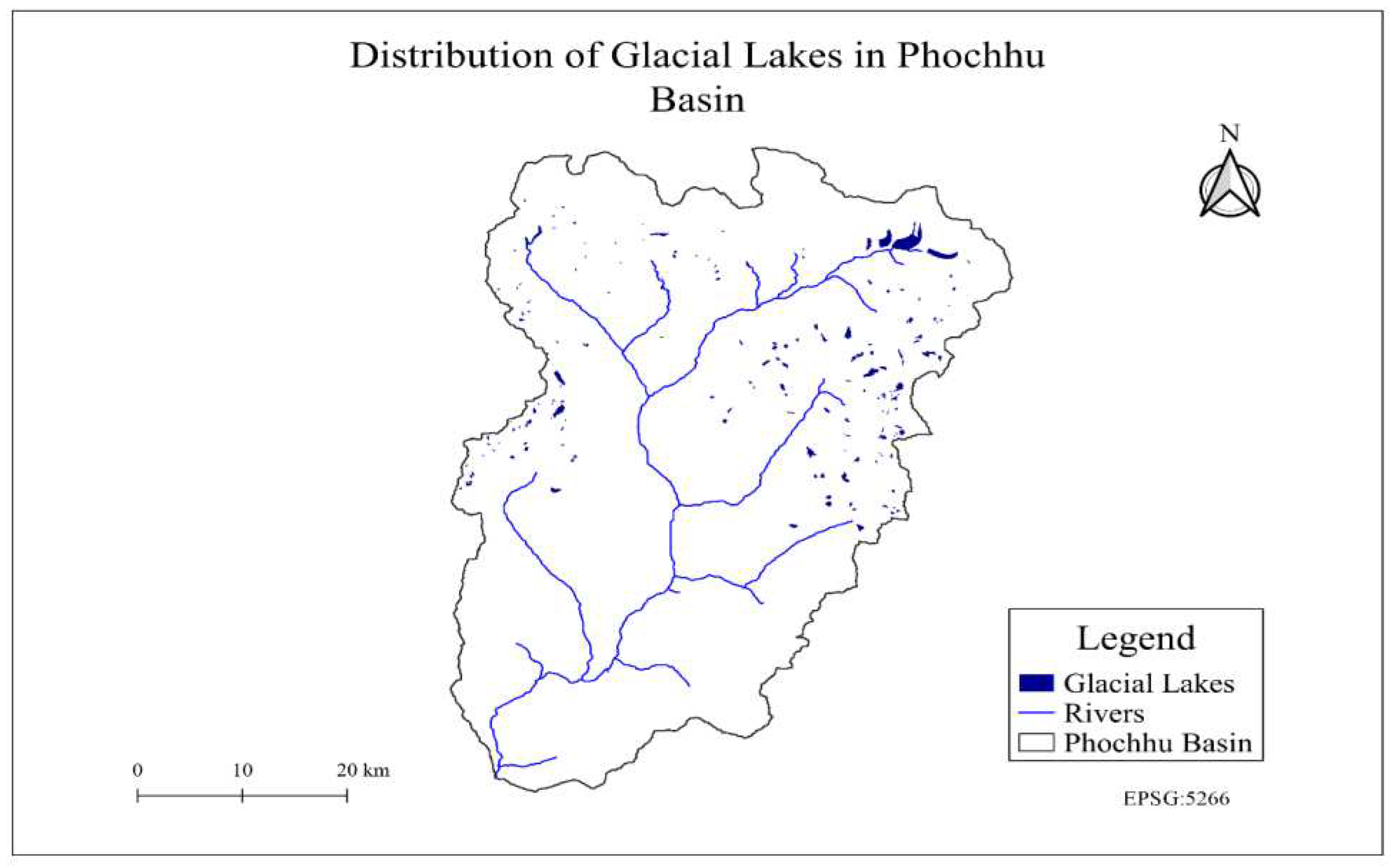
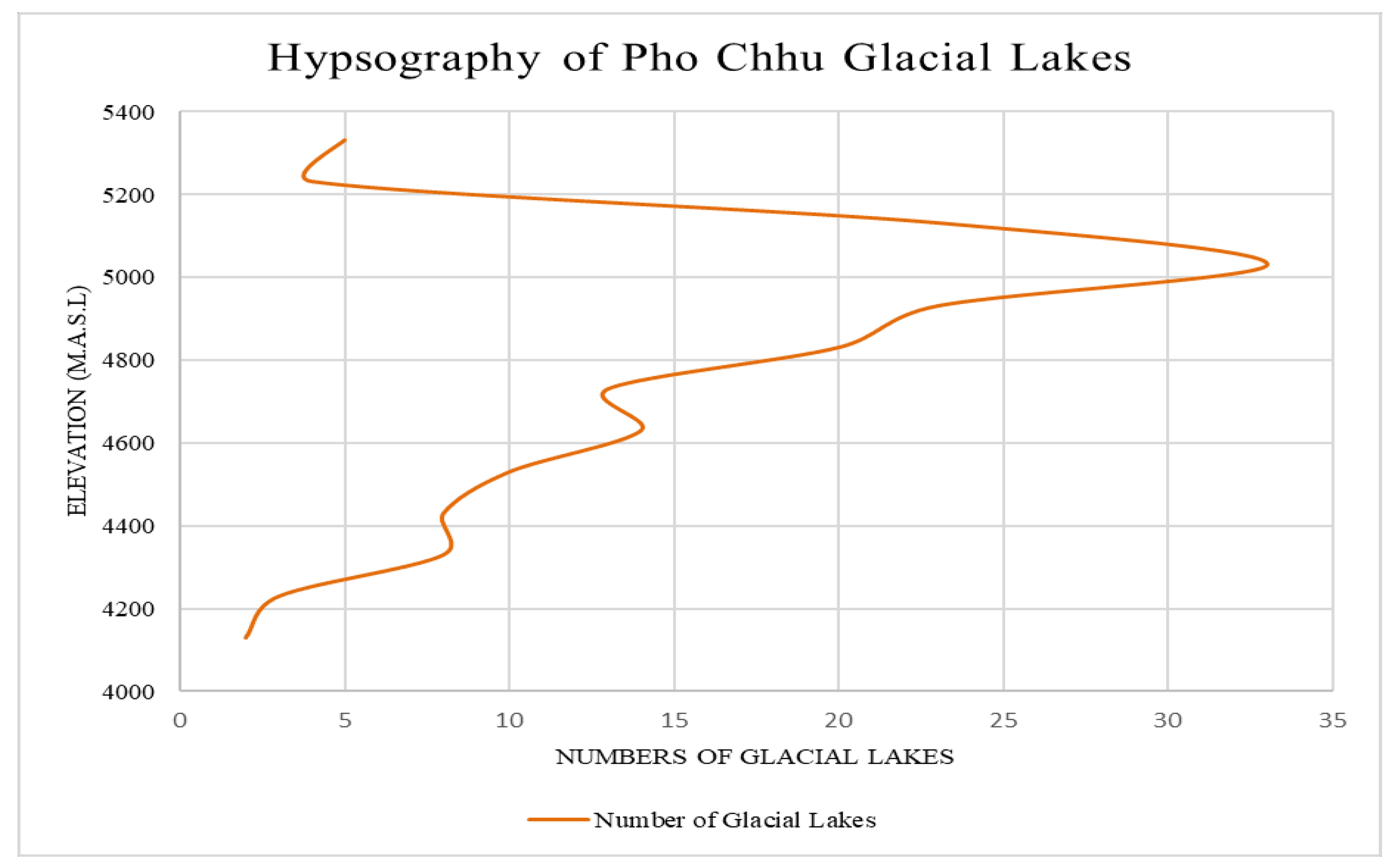
| Sl.no | Types of area calculated | Total Features | Area (Sq.km) | Area (%) |
|---|---|---|---|---|
| 1 | Area with all features | 4463 features | 18.843 | 0.05 |
| 2 | Area with shadows ( after Criteria) | 233 features | 16.344 | 0.04 |
| 3 | Area without/removal of shadows | 131 features | 12.574 | 0.03 |
| 4 | The final glacial lake area | 166 features | 24.051 | 0.06 |
| ICIMOD 2001 (For Phochhu basin) |
BGLI 2021 (For Phochhu basin) |
PGLI 2021 (Phochhu Basin) |
|
|---|---|---|---|
| Number | 549 | 157 | 166 |
| Area (km2) | 23.49 | 20.98 | 24.051 |
Disclaimer/Publisher’s Note: The statements, opinions and data contained in all publications are solely those of the individual author(s) and contributor(s) and not of MDPI and/or the editor(s). MDPI and/or the editor(s) disclaim responsibility for any injury to people or property resulting from any ideas, methods, instructions or products referred to in the content. |
© 2023 by the authors. Licensee MDPI, Basel, Switzerland. This article is an open access article distributed under the terms and conditions of the Creative Commons Attribution (CC BY) license (http://creativecommons.org/licenses/by/4.0/).


