Submitted:
11 October 2023
Posted:
11 October 2023
You are already at the latest version
Abstract
Keywords:
1. Introduction
2. Materials and Methods
2.1. Location of the study area
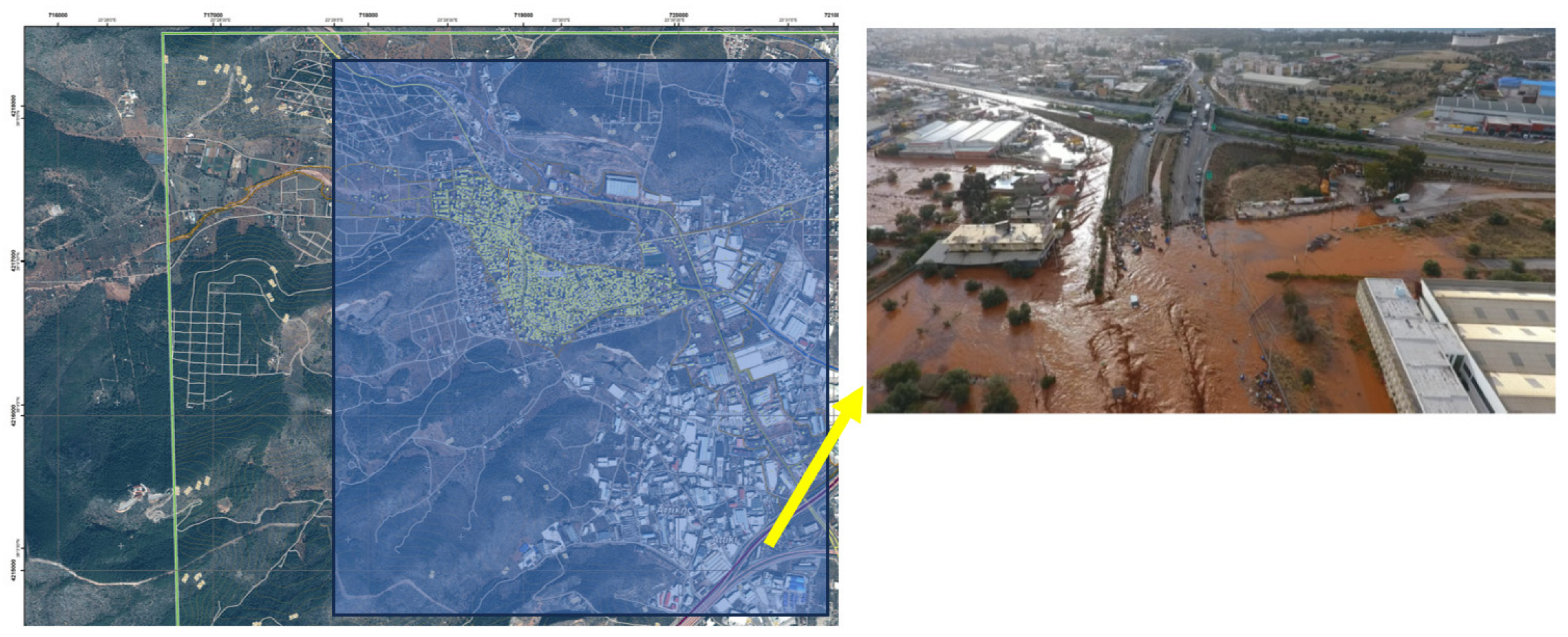
2.2. The fatal flash flood event of Mandra (11/2017).
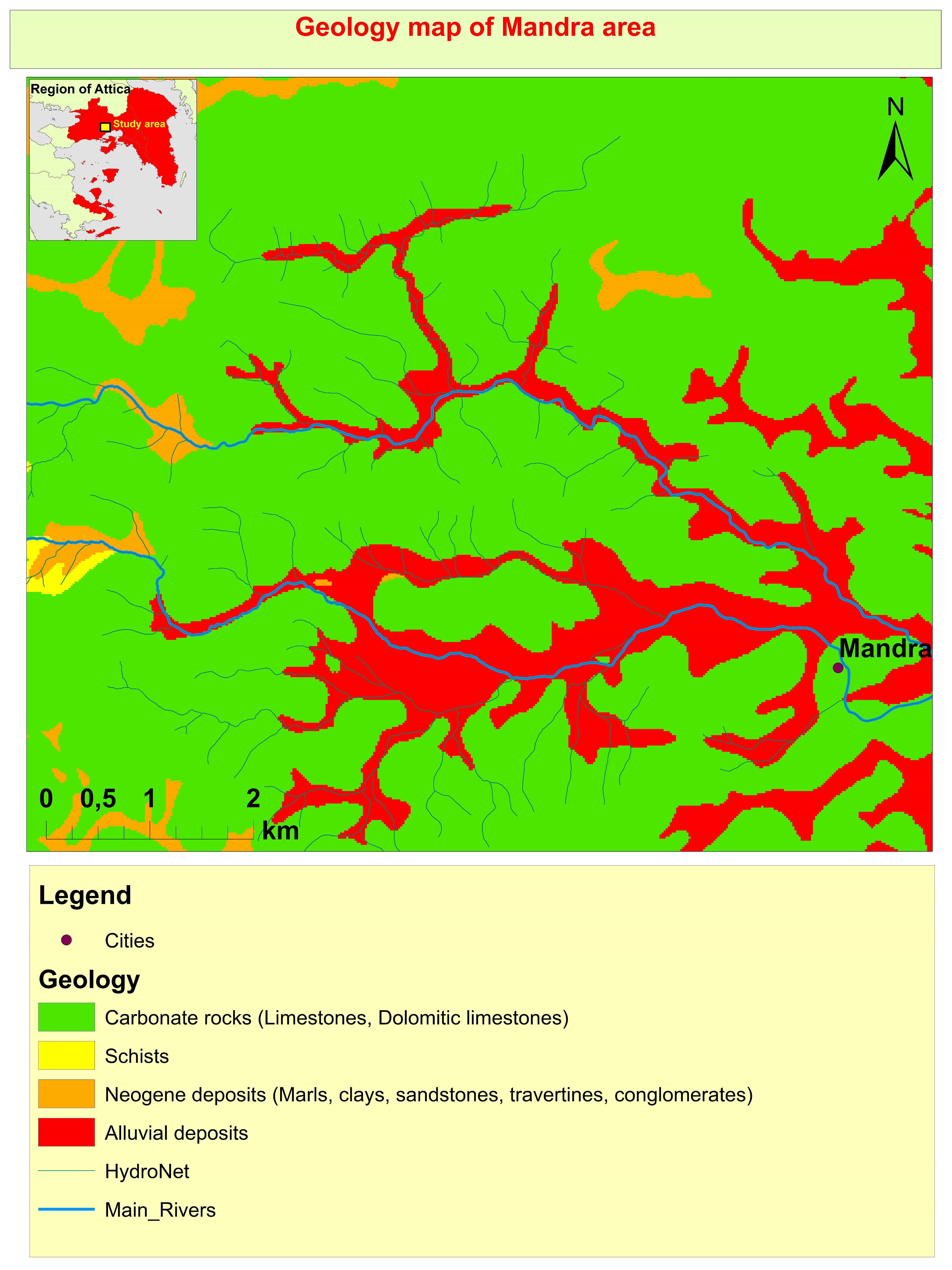
2.3. Geological setting
2.4. On site geological findings
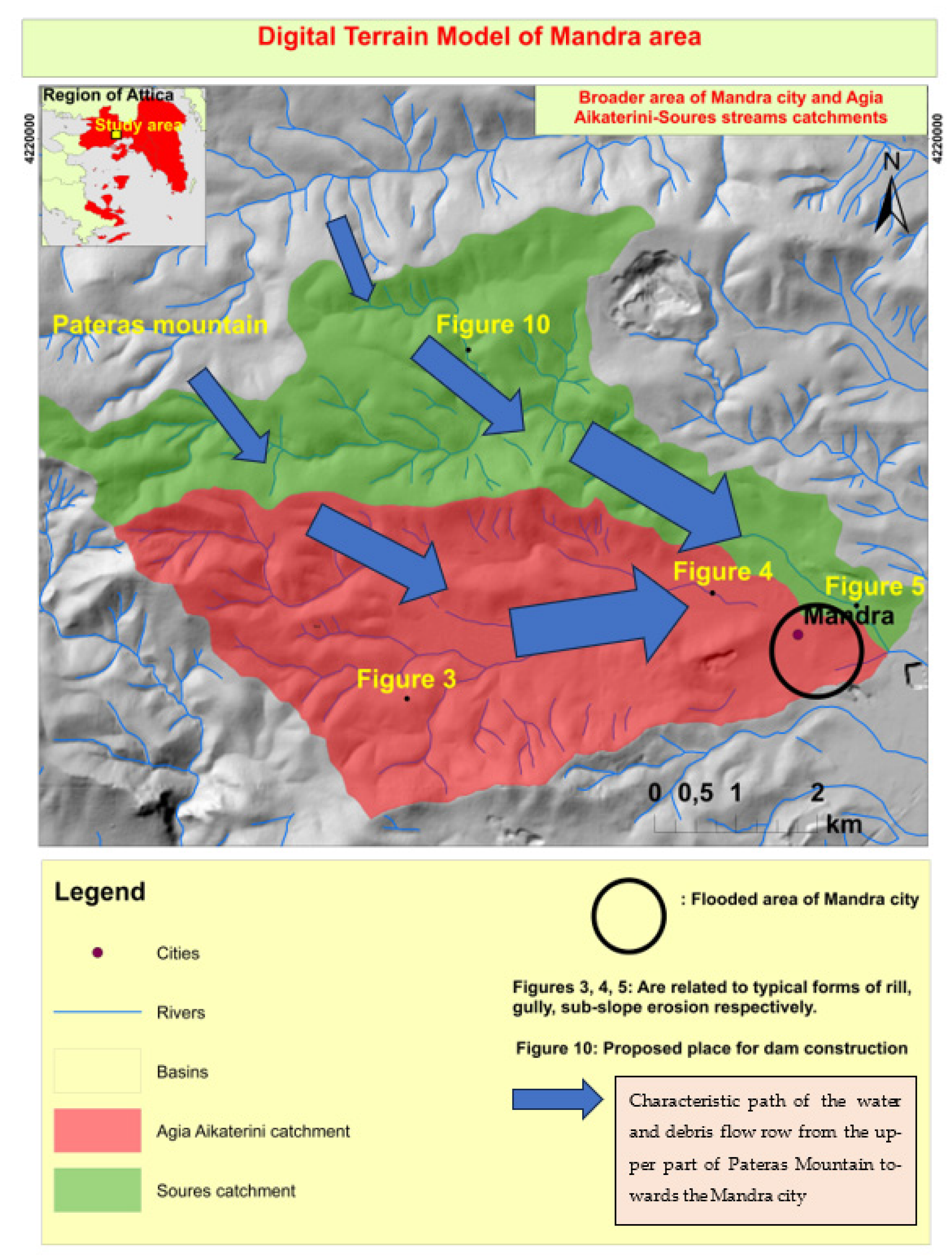
2.5. Causes of the Mandra flood.
2.6. Soil erosion - Erodibility
2.6.1. Surface (sheet) erosion
2.6.2. Rill erosion
2.6.3. Gully erosion
2.6.4. Slope and sub-slope erosion (Riverbank erosion)
2.7. Modeling of Soil Erosion.
2.7.1. Susceptibility to soil erosion
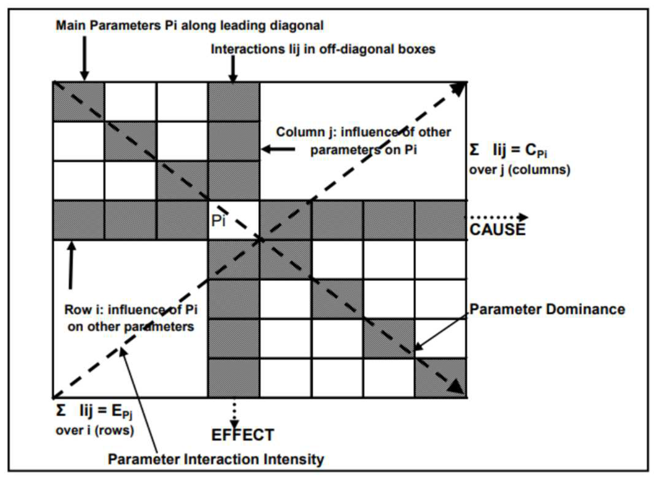
2.7.2. Rock Engineering System (RES) methodology.
3. Results
3.1. Mapping performance evaluation
4. Discussion
4.1. Prevention and control actions
- a reduction in the amount of solid material transported, with a corresponding reduction in the erosive capacity of the flood waters and the volume of the flood wave.
- The velocity of the flood wave is reduced, resulting in a delay in its occurrence downstream and a reduction in its destructive momentum.
- The effects of erosion on unprotected soils are reduced.
- The natural environment is protected and enhanced, especially through planting and soil protection projects.
- Construction of small dams to grade the bed and retain the slopes
- Construction of dams for the retention of debris
- Construction of culverts in places where the existing road network is eroded by streams in the study area
- Settlement of part of the hydrographic network of the study area by constructing an artificial bed with a dike
- Implementation of horticultural works
- Forestry measures for the management of the overall forest complex in the study area
- Opening of forest roads to reach the sites of the proposed projects
- (a)
- Construction of sediment barriers is intended to be between 3m and 8m high with reinforced concrete or unreinforced concrete construction material. The purpose of these dams is to counteract the axial erosion of the bottom of the stream bed, by reducing the drag force of the water and retaining the sediment.
- (b)
- Construction of graduation dams - slope stabilization: These dams are proposed to be made of concrete (reinforced or unreinforced) or of reinforced wire mesh (e.g., sarsenet). The construction of the dams will be carried out either in places where there is evidence of gradual erosion, or in places where there is axial erosion of the bottom of the bed, in combination with the above-mentioned sediment barriers. The height of these dams according to the theoretical assessment carried out, is proposed to be between 1m and 2m.
5. Conclusions
Funding
Acknowledgments
Conflicts of Interest
References
- Borrelli, P.; Poesen, J.; Vanmaercke, M.; Ballabio, C.; Hervás, J.; Maerker, M.; Scarpa, S.; Panagos, P. Monitoring gully erosion in the European Union: A novel approach based on the Land Use/Cover Area frame survey (LUCAS). Int. Soil Water Conserv. Res. 2021, 10, 17–28. [Google Scholar] [CrossRef]
- Panagos, P. , Van Liedekerke M., Jones A., Montanarella L., 2011. European Soil Data Centre: Response to European policy support and public data requirements. Land Use Policy 29 (2012): 329-338. [CrossRef]
- Senanayake, S.; Pradhan, B.; Huete, A.; Brennan, J. A Review on Assessing and Mapping Soil Erosion Hazard Using Geo-Informatics Technology for Farming System Management. Remote. Sens. 2020, 12, 4063. [Google Scholar] [CrossRef]
- Karydas, C.G.; Panagos, P.; Gitas, I.Z. A classification of water erosion models according to their geospatial characteristics. Int. J. Digit. Earth 2014, 7, 229–250. [Google Scholar] [CrossRef]
- Teng, H.; Liang, Z.; Chen, S.; Liu, Y.; Rossel, R.A.V.; Chappell, A.; Yu, W.; Shi, Z. Current and future assessments of soil erosion by water on the Tibetan Plateau based on RUSLE and CMIP5 climate models. Sci. Total. Environ. 2018, 635, 673–686. [Google Scholar] [CrossRef] [PubMed]
- Wischmeier, W. , Smith D., 1978. Predicting Rainfall Erosion Losses: A Guide to Conservation Planning. Agricultural Handbook No. 537. U.S. Department of Agriculture, Washington DC, USA.
- Renard, K.G. , et al., 1997. Predicting Soil Erosion by Water: A Guide to Conservation Planning with the Revised Universal Soil Loss Equation (RUSLE) (Agricultural Handbook 703). US Department of Agriculture, Washington, DC, pp.404.
- Panagos, P.; Borrelli, P.; Poesen, J.; Ballabio, C.; Lugato, E.; Meusburger, K.; Montanarella, L.; Alewell, C. The new assessment of soil loss by water erosion in Europe. Environ. Sci. Policy 2015, 54, 438–447. [Google Scholar] [CrossRef]
- Senanayake, S.; Pradhan, B.; Huete, A.; Brennan, J. Assessing Soil Erosion Hazards Using Land-Use Change and Landslide Frequency Ratio Method: A Case Study of Sabaragamuwa Province, Sri Lanka. Remote. Sens. 2020, 12, 1483. [Google Scholar] [CrossRef]
- Batista, P.V.; Davies, J.; Silva, M.L.; Quinton, J.N. On the evaluation of soil erosion models: Are we doing enough? Earth-Science Rev. 2019, 197. [Google Scholar] [CrossRef]
- Gholami, V.; Sahour, H.; Amri, M.A.H. Soil erosion modeling using erosion pins and artificial neural networks. CATENA 2021, 196, 104902. [Google Scholar] [CrossRef]
- Cohen, M.J.; Shepherd, K.D.; Walsh, M.G. Empirical reformulation of the universal soil loss equation for erosion risk assessment in a tropical watershed. Geoderma 2005, 124, 235–252. [Google Scholar] [CrossRef]
- Arabameri, A.; Pradhan, B.; Rezaei, K.; Yamani, M.; Pourghasemi, H.R.; Lombardo, L. Spatial modelling of gully erosion using evidential belief function, logistic regression, and a new ensemble of evidential belief function-logistic regression algorithm. Land Degrad. Dev. 2018, 29, 4035–4049. [Google Scholar] [CrossRef]
- Conforti, M.; Aucelli, P.P.C.; Robustelli, G.; Scarciglia, F. Geomorphology and GIS analysis for mapping gully erosion susceptibility in the Turbolo stream catchment (Northern Calabria, Italy). Nat. Hazards 2011, 56, 881–898. [Google Scholar] [CrossRef]
- Conoscenti, C.; Angileri, S.; Cappadonia, C.; Rotigliano, E.; Agnesi, V.; Märker, M. Gully erosion susceptibility assessment by means of GIS-based logistic regression: A case of Sicily (Italy). Geomorphology 2014, 204, 399–411. [Google Scholar] [CrossRef]
- Arabameri, A.; Cerda, A.; Tiefenbacher, J.P. Spatial Pattern Analysis and Prediction of Gully Erosion Using Novel Hybrid Model of Entropy-Weight of Evidence. Water 2019, 11, 1129. [Google Scholar] [CrossRef]
- Arabameri, A.; Cerda, A.; Pradhan, B.; Tiefenbacher, J.P.; Lombardo, L.; Bui, D.T. A methodological comparison of head-cut based gully erosion susceptibility models: Combined use of statistical and artificial intelligence. Geomorphology 2020, 359, 107136. [Google Scholar] [CrossRef]
- Meliho, M.; Khattabi, A.; Mhammdi, N. A GIS-based approach for gully erosion susceptibility modelling using bivariate statistics methods in the Ourika watershed, Morocco. Environ. Earth Sci. 2018, 77, 655. [Google Scholar] [CrossRef]
- Rahmati, O.; Haghizadeh, A.; Pourghasemi, H.R.; Noormohamadi, F. Gully erosion susceptibility mapping: the role of GIS-based bivariate statistical models and their comparison. Nat. Hazards 2016, 82, 1231–1258. [Google Scholar] [CrossRef]
- Angileri, S.E.; Conoscenti, C.; Hochschild, V.; Märker, M.; Rotigliano, E.; Agnesi, V. Water erosion susceptibility mapping by applying Stochastic Gradient Treeboost to the Imera Meridionale River Basin (Sicily, Italy). Geomorphology 2016, 262, 61–76. [Google Scholar] [CrossRef]
- Svoray, T.; Michailov, E.; Cohen, A.; Rokah, L.; Sturm, A. Predicting gully initiation: comparing data mining techniques, analytical hierarchy processes and the topographic threshold. Earth Surf. Process. Landforms 2012, 37, 607–619. [Google Scholar] [CrossRef]
- Eustace, A.H.; Pringle, M.J.; Denham, R.J. A risk map for gully locations in central Queensland, Australia. Eur. J. Soil Sci. 2011, 62, 431–441. [Google Scholar] [CrossRef]
- Rahmati, O.; Tahmasebipour, N.; Haghizadeh, A.; Pourghasemi, H.R.; Feizizadeh, B. Evaluation of different machine learning models for predicting and mapping the susceptibility of gully erosion. Geomorphology 2017, 298, 118–137. [Google Scholar] [CrossRef]
- Arabameri, A.; Rezaei, K.; Cerda, A.; Lombardo, L.; Rodrigo-Comino, J. GIS-based groundwater potential mapping in Shahroud plain, Iran. A comparison among statistical (bivariate and multivariate), data mining and MCDM approaches. Sci. Total. Environ. 2018, 658, 160–177. [Google Scholar] [CrossRef] [PubMed]
- Pourghasemi, H.R.; Yousefi, S.; Kornejady, A.; Cerdà, A. Performance assessment of individual and ensemble data-mining techniques for gully erosion modeling. Sci. Total. Environ. 2017, 609, 764–775. [Google Scholar] [CrossRef]
- Yang, A.; Wang, C.; Pang, G.; Long, Y.; Wang, L.; Cruse, R.M.; Yang, Q. Gully Erosion Susceptibility Mapping in Highly Complex Terrain Using Machine Learning Models. ISPRS Int. J. Geo-Information 2021, 10, 680. [Google Scholar] [CrossRef]
- Huang, F.; Chen, J.; Du, Z.; Yao, C.; Huang, J.; Jiang, Q.; Chang, Z.; Li, S. Landslide Susceptibility Prediction Considering Regional Soil Erosion Based on Machine-Learning Models. ISPRS Int. J. Geo-Inf. 2020, 9, 377. [Google Scholar] [CrossRef]
- Rozos, D.; Skilodimou, H.D.; Loupasakis, C.; Bathrellos, G.D. Application of the revised universal soil loss equation model on landslide prevention. An example from N. Euboea (Evia) Island, Greece. Environ. Earth Sci. 2013, 70, 3255–3266. [Google Scholar] [CrossRef]
- Brunsden, D. , & Prior, D. B., 1984. Slope instability. Wiley, Singapore.
- Lim, R. P.,&Lee, S. W., 1992. Hill development. In Proceedings of the Seminar, Malaysian Nature Society, Kuala Lumpur.
- Gartner, J.E. , Bigio, E.R., Cannon, S.H., 2004. Compilation of postwildfire runoff-event data from the western United States. Open- File Report (United States Geological Survey) 04-1085, Available online: http://pubs.usgs.gov/of/2004/1085.html.
- Poesen, J. Soil erosion in the Anthropocene: Research needs. Earth Surf. Process. Landforms 2018, 43, 64–84. [Google Scholar] [CrossRef]
- Nyssen, J.; Poesen, J.; Moeyersons, J.; Luyten, E.; Veyret-Picot, M.; Deckers, J.; Haile, M.; Govers, G. Impact of road building on gully erosion risk: a case study from the Northern Ethiopian Highlands. Earth Surf. Process. Landforms 2002, 27, 1267–1283. [Google Scholar] [CrossRef]
- Lee, S. Soil erosion assessment and its verification using the Universal Soil Loss Equation and Geographic Information System: a case study at Boun, Korea. Environ. Geol. 2004, 45, 457–465. [Google Scholar] [CrossRef]
- Pradhan B, Chaudhari A, Adinarayana J, Buchroithner MF., 2012. Soil erosion assessment and its correlation with landslide events using remote sensing data and GIS: a case study at Penang Island, Malaysia. Environ Monit Assess 184:715–727. https://doi 10.1007/s10661-011-1996-8.
- Yuan-Jun, J.; Alam, M.; Li-Jun, S.; Umar, M.; Sadiq, S.; Jia, L.J.; Rahman, M. Effect of root orientation on the strength characteristics of loess in drained and undrained triaxial tests. Eng. Geol. 2022, 296, 106459. [Google Scholar] [CrossRef]
- Lian, B.; Peng, J.; Zhan, H.; Huang, Q.; Wang, X.; Hu, S. Formation mechanism analysis of irrigation-induced retrogressive loess landslides. CATENA 2020, 195, 104441. [Google Scholar] [CrossRef]
- Swanson, F.J.; Dyrness, C.T. Impact of clear-cutting and road construction on soil erosion by landslides in the western Cascade Range, Oregon. Geology 1975, 3. 393–396. [Google Scholar] [CrossRef]
- Wang, X.; Wang, J.; Zhan, H.; Li, P.; Qiu, H.; Hu, S. Moisture content effect on the creep behavior of loess for the catastrophic Baqiao landslide. CATENA 2020, 187, 104371. [Google Scholar] [CrossRef]
- Shen, P.; Zhang, L.; Chen, H.; Gao, L. Role of vegetation restoration in mitigating hillslope erosion and debris flows. Eng. Geol. 2017, 216, 122–133. [Google Scholar] [CrossRef]
- Wu, L.Z.; Zhang, L.M.; Zhou, Y.; Xu, Q.; Yu, B.; Liu, G.G.; Bai, L.Y. Theoretical analysis and model test for rainfall-induced shallow landslides in the red-bed area of Sichuan. Bull. Eng. Geol. Environ. 2018, 77, 1343–1353. [Google Scholar] [CrossRef]
- Acharya, G.; Cochrane, T.; Davies, T.; Bowman, E. Quantifying and modeling post-failure sediment yields from laboratory-scale soil erosion and shallow landslide experiments with silty loess. Geomorphology 2011, 129, 49–58. [Google Scholar] [CrossRef]
- Lin, W.-T.; Lin, C.-Y.; Chou, W.-C. Assessment of vegetation recovery and soil erosion at landslides caused by a catastrophic earthquake: A case study in Central Taiwan. Ecol. Eng. 2006, 28, 79–89. [Google Scholar] [CrossRef]
- Belayneh, L.; Dewitte, O.; Gulie, G.; Poesen, J.; O’hara, D.; Kassaye, A.; Endale, T.; Kervyn, M. Landslides and Gullies Interact as Sources of Lake Sediments in a Rifting Context: Insights from a Highly Degraded Mountain Environment. Geosciences 2022, 12, 274. [Google Scholar] [CrossRef]
- Mackey, B.H.; Roering, J.J. Sediment yield, spatial characteristics, and the long-term evolution of active earthflows determined from airborne LiDAR and historical aerial photographs, Eel River, California. GSA Bull. 2011, 123, 1560–1576. [Google Scholar] [CrossRef]
- Poesen, J. Soil erosion in the Anthropocene: Research needs. Earth Surf. Process. Landforms 2018, 43, 64–84. [Google Scholar] [CrossRef]
- Kubwimana, D.; Brahim, L.A.; Nkurunziza, P.; Dille, A.; Depicker, A.; Nahimana, L.; Abdelouafi, A.; Dewitte, O. Characteristics and Distribution of Landslides in the Populated Hillslopes of Bujumbura, Burundi. Geosciences 2021, 11, 259. [Google Scholar] [CrossRef]
- Huang, F.; Chen, J.; Du, Z.; Yao, C.; Huang, J.; Jiang, Q.; Chang, Z.; Li, S. Landslide Susceptibility Prediction Considering Regional Soil Erosion Based on Machine-Learning Models. ISPRS Int. J. Geo-Inf. 2020, 9, 377. [Google Scholar] [CrossRef]
- Kou, P.; Xu, Q.; Yunus, A.P.; Liu, J.; Xu, Y.; Wang, C.; Li, H.; Wei, Y.; Dong, X. Landslide-controlled soil erosion rate in the largest tableland on the Loess Plateau, China. Hum. Ecol. Risk Assessment: Int. J. 2019, 26, 2478–2499. [Google Scholar] [CrossRef]
- Varnes, D.J. , 1978. Slope Movement Types and Processes. In: Schuster, R.L. and Krizek, R.J., Eds., Landslides, Analysis and Control, Transportation Research Board, Special Report No. 176, National Academy of Sciences, 11-33.
- Tavoularis, N.; Papathanassiou, G.; Ganas, A.; Argyrakis, P. Development of the Landslide Susceptibility Map of Attica Region, Greece, Based on the Method of Rock Engineering System. Land 2021, 10, 148. [Google Scholar] [CrossRef]
- Wilde, M.; Günther, A.; Reichenbach, P.; Malet, J.-P.; Hervás, J. Pan-European landslide susceptibility mapping: ELSUS Version 2. J. Maps 2018, 14, 97–104. [Google Scholar] [CrossRef]
- Regional Authority of Attica/Directorate of Technical Works, H.S.G.M.E., 2018. Integrated geological survey for the reduction of flood risk in the wider region of Mandra, Attica – Measures for the prevention and mitigation of flooding phenomena (Hellenic Survey for Geology and Mineral Exploration (H.S.G.M.E.) – Deliverable ΙΙ (unpublished).
- COPERNICUS - Emergency Management Service – Mapping. EMSR257: Flood in Attika, Greece. Available online: https://emergency.copernicus.eu/mapping/list-of-components/EMSR257/ALL/EMSR257_01MANDRA.
- Lekkas E., Voulgaris N., Lozios S. (2017). Flash Flood in West Attica (Mandra, Nea Peramos) November 15, 2017. Newsletter of Environmental, Disaster and Crisis Management Strategies Issue No 5, Hellenic Republic National & Kapodistrian University of Athens. Available online: https://edcm.edu.gr/images/docs/newsletters/Newsletter201705_Mandra-Floods-eng.pdf.
- Li, Z.; Fang, H. Impacts of climate change on water erosion: A review. Earth-Science Rev. 2016, 163, 94–117. [Google Scholar] [CrossRef]
- Labrière, N.; Locatelli, B.; Laumonier, Y.; Freycon, V.; Bernoux, M. Soil erosion in the humid tropics: A systematic quantitative review. Agric. Ecosyst. Environ. 2015, 203, 127–139. [Google Scholar] [CrossRef]
- Li, Y.; Mo, P. A unified landslide classification system for loess slopes: A critical review. Geomorphology 2019, 340, 67–83. [Google Scholar] [CrossRef]
- Blasche P.M, Trustrum N.A., Hicks D.L. Impacts of mass movement erosion on land productivity: A review. Prog. Phys. Geogr. Earth Environ. 2000, 24, 21-52.
- Ayanlade, A.; Jegede, M.O.; Borisade, P.B. Geoinformatics in eco-climatic studies. In Encyclopedia of Information Science and Technology, 3rd ed.; Information Resources Management Association: Hershey, PA, USA, 2014; pp. 3136–3144. [Google Scholar]
- Dang, K.; Sassa, K.; Konagai, K.; Karunawardena, A.; Bandara, R.M.S.; Hirota, K.; Tan, Q.; Ha, N.D. Recent rainfall-induced rapid and long-traveling landslide on 17 May 2016 in Aranayaka, Kagelle District, Sri Lanka. Landslides 2019, 16, 155–164. [Google Scholar] [CrossRef]
- Marinos, P. , Plessas S., Valadaki-Plessa K., 1998. Thematic maps on the risk assessment of erosion and sediment production in Attica. Proceedings of the 4th Panhellenic Geographical Conference, pp.584-616, Athens.
- Glade, T. Landslide occurrence as a response to land use change: a review of evidence from New Zealand. CATENA 2003, 51, 297–314. [Google Scholar] [CrossRef]
- Reichenbach, P. , Galli M., Cardinali M., Guzzetti F., Ardizzone F., 2004. Geomorphological mapping to assess landslide risk: Concepts, methods and applications in the Umbria region of central Italy. Landslide Hazard Risk, 429–468.
- Vianello, D.; Vagnon, F.; Bonetto, S.; Mosca, P. Debris flow susceptibility mapping using the Rock Engineering System (RES) method: a case study. Landslides 2023, 20, 735–756. [Google Scholar] [CrossRef]
- Greece Republic, Region of Attica, Directorate for flood protection works, Hydroment Consulting Engineers S.A. - Kritsotakis G. (2021). Delimitation, settlement and damming of the Soures and Agia Aikaterini streams north of the town of Mandra. Unpublished technical report.
- Hudson, J. , 1992. Rock Engineering Systems: Theory and Practice. Ellis Horwood Limited: Chichester.
- Hudson, J. , 2013. A Review of Rock Engineering Systems (RES) Applications over the Last 20 Years; Department of Earth Science and Engineering, Imperial College: London, UK.
- Tavoularis, N.; Koumantakis, I.; Rozos, D.; Koukis, G. An implementation of rock engineering system (RES) for ranking the instability potential of slopes in Greek territory. An application in Tsakona area (Peloponnese - prefecture of Arcadia). Bull. Geol. Soc. Greece 2015, 49, 38–58. [Google Scholar] [CrossRef]
- Tavoularis, N.; Koumantakis, I.; Rozos, D.; Koukis, G. The Contribution of Landslide Susceptibility Factors Through the Use of Rock Engineering System (RES) to the Prognosis of Slope Failures: An Application in Panagopoula and Malakasa Landslide Areas in Greece. Geotech. Geol. Eng. 2017, 36, 1491–1508. [Google Scholar] [CrossRef]
- Brabb, E.; Bonilla, M.G.; Pampeyan, E. Landslide Susceptibility in San Mateo County, California. US Geological Survey Miscellaneous Field Studies, Map MF-360, Scale 1:62,500; US Geological Survey: Reston, VA, USA, 1972; reprinted in 1978.
- Varnes, D. IAEG Commission on Landslides and Other Mass-Movements. Landslide Hazard Zonation: A Review of Principles and Practice; UNESCO Press: Paris, France, 1984; 63p.
- Gunther A, Reichenbach P., Wilde M., Jurchescu M., Malet J.P., Hervas J (2022). New perspectives on the Europe-wide landslide susceptibility assessment (ELSUS). 2nd EU Soil Observatory Stakeholders Forum, 24-26 June 2022, online.
- Reichenbach P., Gunther A, Rossi M. (2022). Susceptibility to mass movements at different scales. 2nd EU Soil Observatory Stakeholders Forum, 24-26 June 2022, online.
- Tavoularis N. (2022). Soil erosion and landslide susceptibility mapping using Rock Engineering System methodology. The case of Mandra fatal flash flood (2017) in Western Attica, Greece. 2nd EU Soil Observatory Stakeholders Forum, 24-26 June 2022, online. Available online: https://esdac.jrc.ec.europa.eu/euso/presentations-2nd-euso-stakeholders-forum.
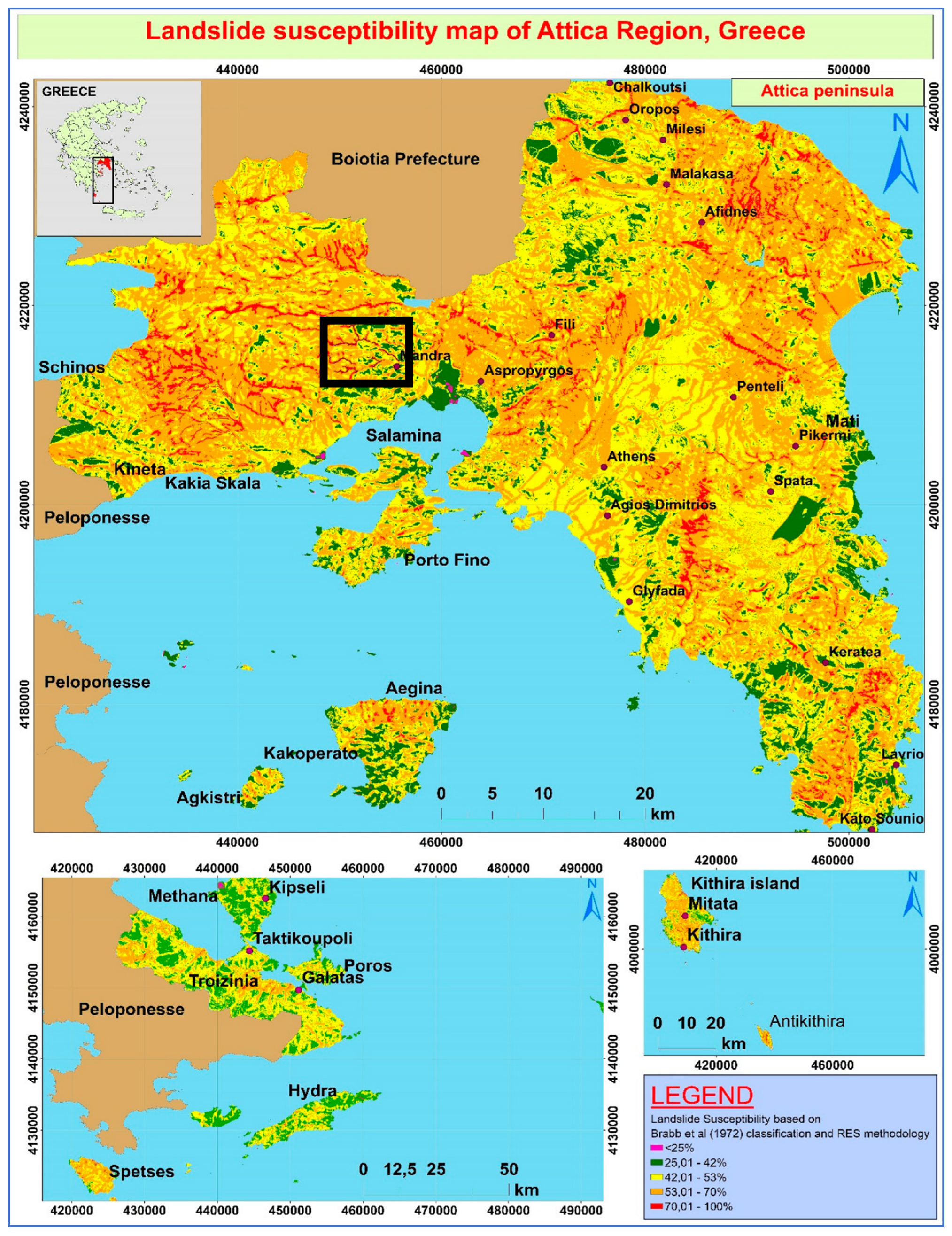
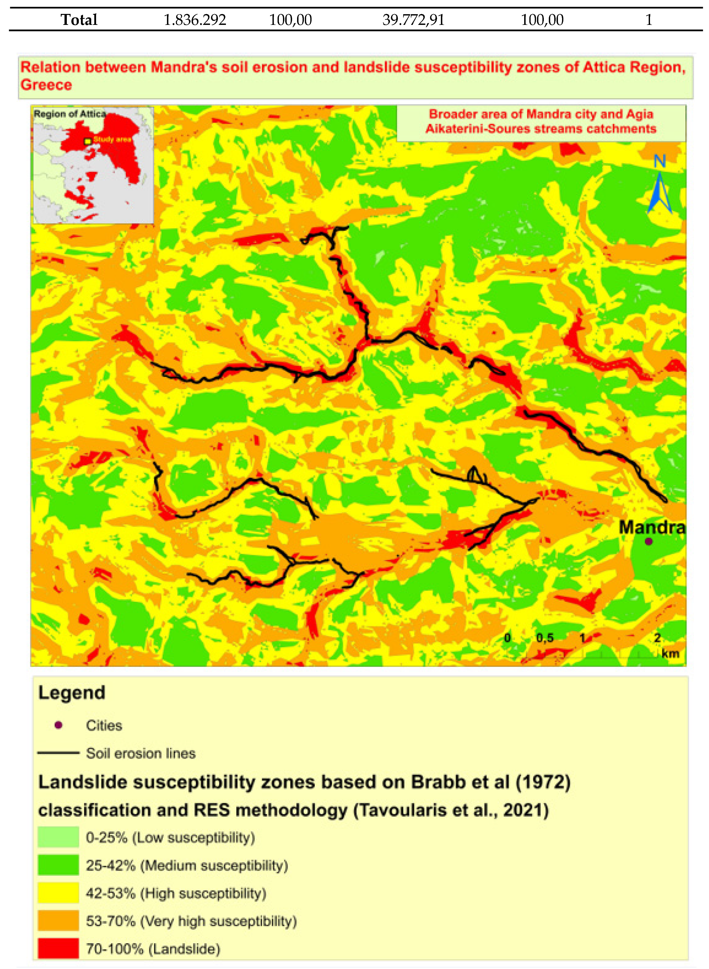
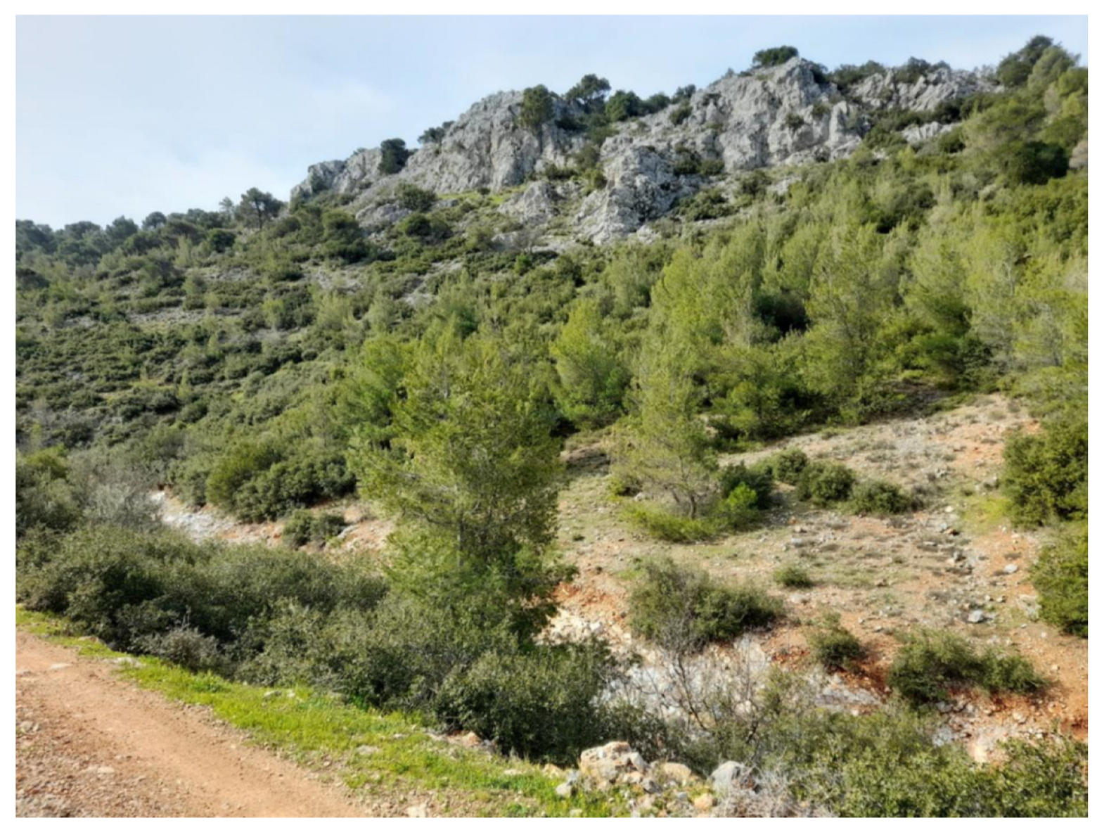
| Methodologies for the assessment of different types of soil erosion | Researchers | Number of References |
|---|---|---|
| Universal Soil Erosion Equation (USLE) | Wischmeier and Smith (1978), Panagos et al. (2015) | [6], [8] |
| Revised USLE | Renard et al. (1997), Panagos et al. (2015) | [7], [8] |
| Frequency Ratio (FR) | Conforti et al., 2011 | [14] |
| Logistic Regression (LR) | Conoscenti et al., 2014 | [15] |
| Analytical Hierarchical process (AHP) | Arabameri et al., 2018 | [13] |
| Weight of Evidence (WoE) | Arabameri et al., 2019 | [16] |
| Machine Learning algorithms | Eustace et al., 2011; Rahmati et al., 2017); Arabameri et al., 2019; Pourghasemi et al., 2017 | [22], [23], [16], [25] |
| Landslide Susceptibility Zones |
Pixel in domain |
Pixels (%) (a) |
Soil Erosion Lines (m) |
Pixels (%) (b) |
Frequency ratio (b/a) |
|---|---|---|---|---|---|
| 42-53% | 777.203 | 42,32 | 917,35 | 2,3 | 0,05 |
| 53,01-70% | 933.057 | 50,81 | 21.920,1 | 55,11 | 1,08 |
| 70.01-100% | 126.032 | 6,87 | 16.935,46 | 42,59 | 6,2 |
| Total | 1.836.292 | 100,00 | 39.772,91 | 100,00 | 1 |
Disclaimer/Publisher’s Note: The statements, opinions and data contained in all publications are solely those of the individual author(s) and contributor(s) and not of MDPI and/or the editor(s). MDPI and/or the editor(s) disclaim responsibility for any injury to people or property resulting from any ideas, methods, instructions or products referred to in the content. |
© 2023 by the authors. Licensee MDPI, Basel, Switzerland. This article is an open access article distributed under the terms and conditions of the Creative Commons Attribution (CC BY) license (http://creativecommons.org/licenses/by/4.0/).
