1. Introduction
Debris flows have great destructive capacity and are associated with terrible social and economic consequences worldwide [
1,
2,
3,
4]. Due to their high energy levels and short response times, these events have caused the loss of a large number of human lives and substantial material losses [
5,
6]. According to [
7], annually these events generate on average approximately 1200 deaths. In the European Alps in the period between 1987 and 2012, debris flows caused the death of more than 200 people and losses of more than 5 billion euros [
8]. In Colombia, between 1921 and 2018, the occurrence of 1,358 events was reported, which caused the death of 3,318 people, affected 1,264,705 people, destroyed 13,698 houses and affected another 23,694 houses [
9]. In Venezuela, heavy rains between 14 and 16 December 1999 generated debris flows that caused about 30,000 deaths and losses estimated at
$1.79 billion [
10]. On July 3, 2021 a large debris flows in Atami, Japan, killed 26 people and damaged 128 houses [
11].
Additionally, due to the effects of climate change and the increased exposure of people and infrastructure, the consequences of these events are expected to be increasingly critical [
12,
13]. However, despite the fact that debris flows represent a great hazard to humans and infrastructure [
14] and that the transported sediments have a high influence on the characteristics of these flows [
2], to date there are few studies available for the determination of this hazard that consider the flow rheology and all the volumes of sediments that could be transported, as for example, those from the potential erosion of the channels. Most available methodologies are based on morphometric parameters [
15,
16] and in empirical equations [
17,
18,
19].
[
20] proposed a methodology for the hazard zoning due to debris flows based on the evaluation of previous events, the identification of the main geomorphological factors, the determination of the magnitude of future events through the implementation of empirical equations and the identification of elements at risk including infrastructure and populations. This methodology allows the mapping of areas subject to critical hazard levels.
Among the studies that in somehow take into account the flow rheology, we find that presented by [
14], who proposed the determination of the debris flow hazard in areas influenced by hydroclimatic events through the implementation of four basic steps: initially a logistic regression is performed in order to determine the factors that have a greater influence on the generation of debris flow; next, a numerical simulation of previous events is carried out using a two-dimensional mathematical model that considers the rheology of a debris flow; subsequently, an analysis of the precipitation prior to the occurrence of the flood is perform; and, finally, based on the results of the previous analyses, a hazard classification matrix is generated from which it is possible to carry out a zoning of the territory.
This paper proposes a new methodology for the hazard zoning due to debris flows. In this methodology the hazard is established based on a flow intensity index, the probability of occurrence of the events and the characteristics of the sediments that can be transported by the flow. The flow intensity index is calculated from the flow velocities and depths, which are obtained through hydrodynamic modeling that considers the rheology of non-Newtonian flows.
This article first briefly describes the phenomenon of debris flows. Next, the methodology proposed for the determination of the hazard by debris flows based on the hydrodynamic characteristics of the flow and the granulometry of the sediments is described. Subsequently, the implementation of the methodology in the Jamundí river basin (Colombia) is presented. Finally, the main conclusions obtained from the development and implementation of the proposed methodology are presented.
2. Intensity of Debris Flows
Debris flows correspond to rapid flows of water and sediments mixed in different proportions that transit through channels with steep slopes, generating a short response time [
5]. The sediments transported during this type of events, whose concentration varies between 40 and 80 % [
21], can come from the riverbed itself [
22,
23] and from the surrounding slopes when pluvial erosion or destabilization of slopes occurs [
24,
25]. The transported material is deposited when the flow reaches low slopes [
26,
27].
Debris flows can be triggered by precipitation, snowmelt, changes in water level (water table), stream erosion, earthquakes, volcanic activity, disturbance by human activities, or any combination of these factors [
28]. On most occasions, these types of events are triggered by heavy rainfall [
29,
30].
According to [
31], the destructive capacity of debris flows is associated with three types of forces: (i) the hydrodynamic force, which corresponds to a combination of the frontal impact of the flow, the dredging effect on the sides of the structure, etc.; (ii) the hydrostatic force; and, (iii) the collisional force due to the debris transported by the flow. The magnitude of these forces is a function of the peak discharge, depth, flow velocity and the volume, concentration and granulometric distribution of the transported sediments.
Debris Flow Intensity Index
In order to classify the hazard generated by debris flows, it is necessary to define a criterion that allows establishing the intensity of the events and that can be associated with different levels of damage observed in events that occurred previously. To establish this criterion, several authors have proposed various expressions, some of them based on empirical and semi-empirical equations and others based on the kinetic energy of classical mechanics for a rigid body [
32].
In this paper, the Debris Flow Intensity Index, I
DF, proposed by [
32] was selected since it can represent the forces that generate damage and, therefore, can be correlated with infrastructure damage. This index is calculated according to the following expression:
where I
DF is the Debris Flow Intensity Index (m
3/s
2),
dmax is the maximum flow depth (m), and
Vmax is the maximum flow velocity (m/s).
3. Materials and Methods
Hazard by debris flow corresponds to the probability of the occurrence of a debris flow with the potential to generate damage in a given site during a certain period of time. The probability of occurrence can be expressed as the frequency of occurrence, which is indicated through the return period.
Hazard due to debris flows is obtained by combining the probability of occurrence of this type of events with indicators of the magnitude of such events. A relatively similar approach in some aspects is followed by [
33].
Considering that the process of mathematical modeling of watersheds prone to experiencing debris flows is highly demanding in terms of information and computational time, the methodology proposed in this paper is composed of two phases, which are described below.
3.1. Phase I: Determination of the hazard due to debris flows in rural areas
Given that the dimensions of the areas susceptible to the phenomenon of debris flows in rural areas can be very large, the simulation process could become very time-consuming. Because of this, the first step is to perform a mathematical modeling of the areas exposed to debris flows using a digital elevation model, DEM, at a scale of 1:25000 or smaller. The modeling of events must be done to cover a wide range of events, for which it is suggested to model the following return periods: 2.33, 5, 10, 25, 50, 75, 100, 200, 300, 400 and 500 years.
For the numerical simulation, a two-dimensional mathematical model averaged in depth should be used that considers the rheology of non-Newtonian flows and allows the incorporation of sediments from slope erosion, landslides and rockfalls. Some of the available models that can be used for this purpose are: FLO2D, RAMMS, RIVERFLOW2D, HEC-RAS AND FLATMODEL.
The input information to a model of these characteristics is constituted by the DEM at scale 1:25000 or smaller, the hydrographs of debris flows corresponding to different return periods, the volumes of sediments associated with these events and the rheological characteristics of the flow.
The results of the mathematical modeling correspond to the depths and velocities of flow in each of the pixels through which the territory has been represented. Using the maximum depths and flow velocities, the IDF is calculated in each pixel by means of equation 1 for all the return periods analyzed.
Since a different I
DF is obtained for each return period, in order to obtain a single value in each pixel, the following equation must be applied, which is similar to that of the mathematical expectation, with the difference that exceedance probabilities are used instead of occurrence probabilities.
where P
j is the Pixel j;
is the combined Debris Flow Intensity Index of pixel
j; is the return period
i;
i is the number of the order of return period, which varied from 1 to T
min up to n for T
max; T
min is the lowest return period from which the I
DF is calculated; T
max is the longest return period analyzed and
is the Debris Flow Intensity Index corresponding to return period i.
The Tmin value can correspond to the return period from which the flood begins or to the return period from which debris flows begin to have a considerable impact on the territory. The selection of the criterion to be applied will depend on the quantity and quality of information available and on expert judgment.
Since debris flows with a relatively low return period have a stronger effect on the value of the combined I
DF than less frequent events, the value of T
min must be obtained with the greatest possible certainty in order to avoid overestimating or underestimating the value of this parameter [
34].
An additional variable represented by the size of the sediments is used to establish the magnitude of the event. Several authors [
35,
36,
37] have pointed out that the capacity of debris flows to generate damage is directly related to the size of the largest blocks transported by the flow. However, considering that the size of the largest block transported by the flow, D
max, can lead to an overestimation of the impact of the event since it could not be representative of the material transported and that the precise estimation of the D
max that could be transported is complex, it is recommended to use the D
90 as a representative size of the blocks that could be mobilized.
Sediments transported in a debris flow can be classified as fine particles, coarse particles, and boulders. According to [
36] fine particles are those with diameter of less than 1 cm, coarse particles have diameters that fluctuate between 1 and 50 cm and boulders have diameters greater than 50 cm. Based on this classification, three ranges of sediment sizes have been established in this methodology for hazard estimation: the first range corresponds to particles with diameter of less than 50 cm, which includes sediments of a relatively small size; the second range includes particles whose diameter fluctuates between 50 cm and 1.0 m, which are considered to be of medium and large size; and the third range corresponds to particles of a diameter greater than 1 m which are considered as quite large. It was established 1 m as the separation diameter between medium and large sediments with quite large sediments because several studies [
38,
39] have shown that boulders with this diameter can have a great impact force, which implies a high destructive power.
To classify the hazard, the variables indicating the magnitude of the debris flow are integrated, as shown in
Table 1. The results obtained by applying these criteria to each pixel will finally allow to obtain the hazard zoning map by debris flows.
3.2. Phase II: Determination of hazard in urban areas, urban expansion areas and areas classified as high and medium hazard in rural areas
Since a debris flow can have disastrous consequences in urban sectors and in rural sectors classified as medium and high hazard, a more detailed analysis must be carried out for these areas to establish more precisely the hazard to which the territory is exposed.
The first step in determining the hazard in these areas consists of the hydrodynamic simulation of debris flows corresponding to different return periods. It is suggested to model the events corresponding to the same return periods used in the modeling of the rural area, that is, 2.33, 5, 10, 25, 50, 75, 100, 200, 300, 400 and 500 years. Since detailed information is required at this stage, a DEM of a higher resolution than that used in rural areas, preferably at a scale of 1:2000, should be used for this purpose.
A two-dimensional mathematical model must be used that includes the rheology of non-Newtonian flows and that, in addition to considering sediments from slope erosion, landslides and rockfalls, has the capacity to represent the dragging of sediments from the scour of the river channel, which can represent a significant fraction of the total sediments transported, changing the behavior of debris flows [
40]. These models usually have a higher computational cost and require more detailed information related to the properties of the flow, the topographic characteristics of the channel and the basin and the sediments transported during the occurrence of the phenomenon. There are single-phase, two-phase and three-phase models that meet these requirements. The selection of the type of model to use is a function of the computational cost, the amount of rheological information available and the skill of the modeler. Among the available models are: IRIC, R.AVAFLOW, D-CLAW, RAMMS and RIVERFLOW2D.
The input information to these models consists of the DEM at scale 1:2000, the rheological characteristics of the flow, the hydrographs of discharges corresponding to different return periods and the estimated volumes of sediments from the scour of the channel, surface erosion of the basin, landslides and rockfalls for the different return periods considered.
Given that the numerical simulation of debris flows is carried out using high quality territorial and flow information and that the models used allow considering the temporal distribution of sediments that are incorporated into the flow, as well as the dragging of sediments from the riverbed, it is considered that the results obtained provide an adequate representation of the physics of debris flows, so it is not necessary to involve flow intensity variables additional to the I
DF (such as sediment particle size) to perform a hazard classification [
33].
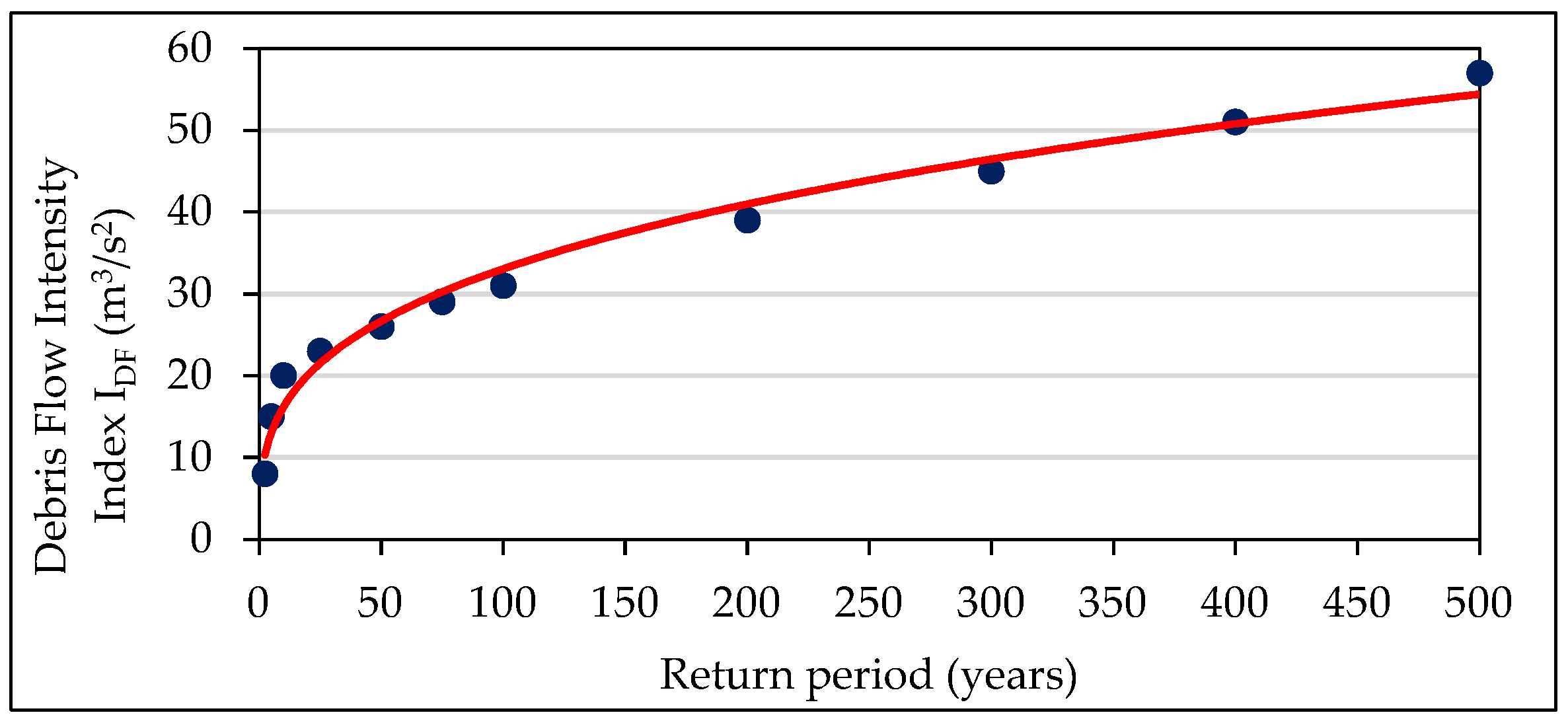
For each of the return periods analyzed, an I
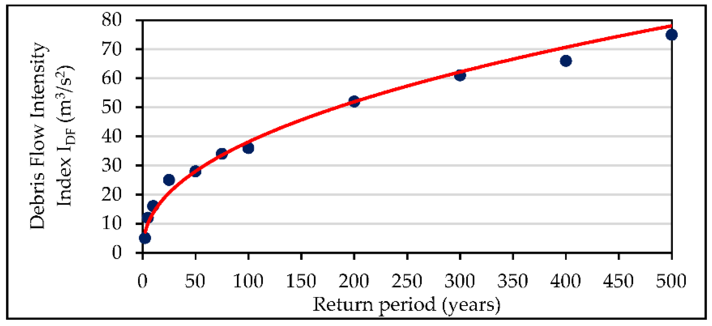
DF value is obtained, which increases as the frequency of occurrence of the events decreases. Using this information, a hazard curve is constructed for each pixel taking the I
DF values as the ordinate axis, and the corresponding return periods as the abscissa axis. For each pixel, a curve similar to the one presented in
Figure 1 is obtained. If in some pixels the number of I
DF values is insufficient to plot a curve, it is suggested to carry out additional return period modeling in order to complement this information.
To carry out the zoning of the territory, the impacts of high frequency events and then the impacts of low frequency events are analyzed independently and finally the results obtained are integrated into a single map.
For events of high frequency of occurrence, their capacity to generate considerable structural damage is evaluated, which occurs, according to the results presented by [
32], when the I
DF is greater than 5 m
3/s
2. In the present methodology, high-frequency events were defined as those corresponding to return periods of 30 and 100 years. The value of 30 years was adopted because in some countries, such as Colombia, it is the return period used for the design of works to protect agricultural areas against floods, and the period of 100 years was adopted because in some countries, such as Spain, Mexico and Colombia, it is a reference value for the determination of flood hazard and risk.
The hazard classification by debris flows of high frequency of occurrence is carried out according to the information recorded in
Table 2. The return period corresponding to the I
DF of 5 m
3/s
2 must be interpolated from the hazard curve plotted in each pixel.
For events of low frequency of occurrence, their capacity to generate severe structural damage is evaluated. Based on the work presented by [
32] it is possible to infer that this situation occurs when the I
DF takes values higher than 25 m
3/s
2. The event corresponding to the 500-year return period was established as an event of low frequency of occurrence because it is taken as a reference in some countries, such as Spain and Colombia, for the determination of the floods hazard and risk.
For the classification of the hazard due to debris flows with low frequency of occurrence, the I
DF value corresponding to the 500-year return period must be determined in each pixel by means of the hazard curve, and then the hazard level must be established according to the classification presented in
Table 3.
Finally, the hazard zoning map by debris flows is established by integrating the two classifications obtained previously (for the events of high and low frequency of occurrence) assigning to each pixel the higher of the two hazard levels obtained in them.
4. Application to a Case Study
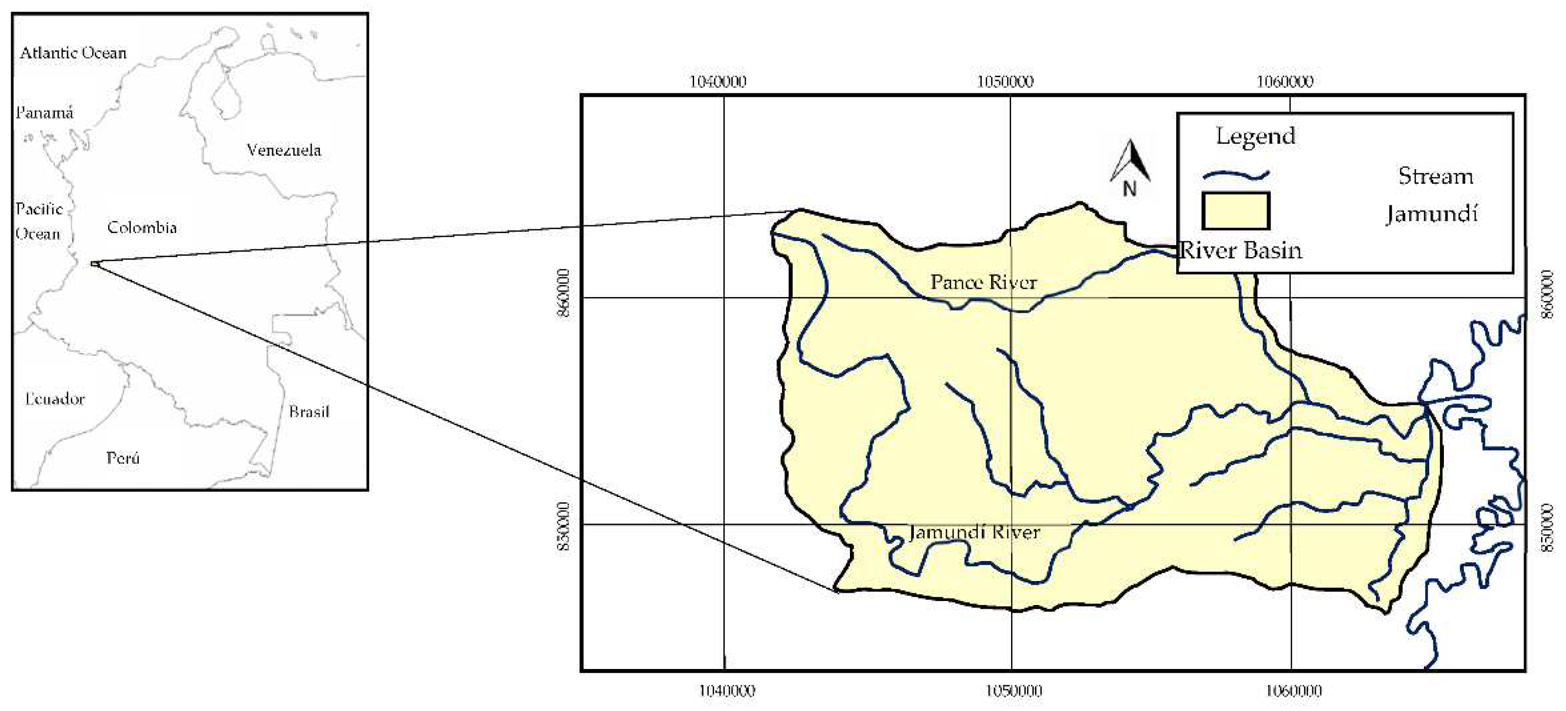
In order to establish its applicability, the proposed methodology was used to determine the hazard due to debris flows in the Jamundí River basin, which is located in Colombia (
Figure 2).
4.1. Characterization of the study area
The Jamundí River has a length of 41.2 km, it is born in the Colombian western mountain range at an altitude of 3900 masl and flows into the Cauca River at an altitude of 950 masl. Its drainage basin has an area of 164 km
2 and an average slope of 28%. It has an average discharge of 10.90 m
3/s and a bimodal rainfall regime with two rainy periods (March to May and October to December) and two periods of moderate rainfall (January to February and June to September). The average annual precipitation of the basin fluctuates between approximately 3500 mm in the upper part to approximately 2200 mm in the lower part. In its basin are located the municipality of Jamundí and the southern part of the municipality of Cali [
41]. The municipality of Jamundí, which could be seriously affected by a debris flow of the Jamundí River, has a population of 131,000 people, of which approximately 80% live in the urban area [
42].
4.2. Input information to the mathematical models
For the determination of the hazard, mathematical modeling of debris flows corresponding to different return periods must be carried out using two different types of mathematical models, in which different input information is introduced. This information, corresponding to the DEM, hydrological information, sedimentological information and rheological characteristics of the flow, was provided by the Universidad del Valle and the Colombian Geological Service [
43].
4.2.1. Digital Terrain Elevation Models DEM
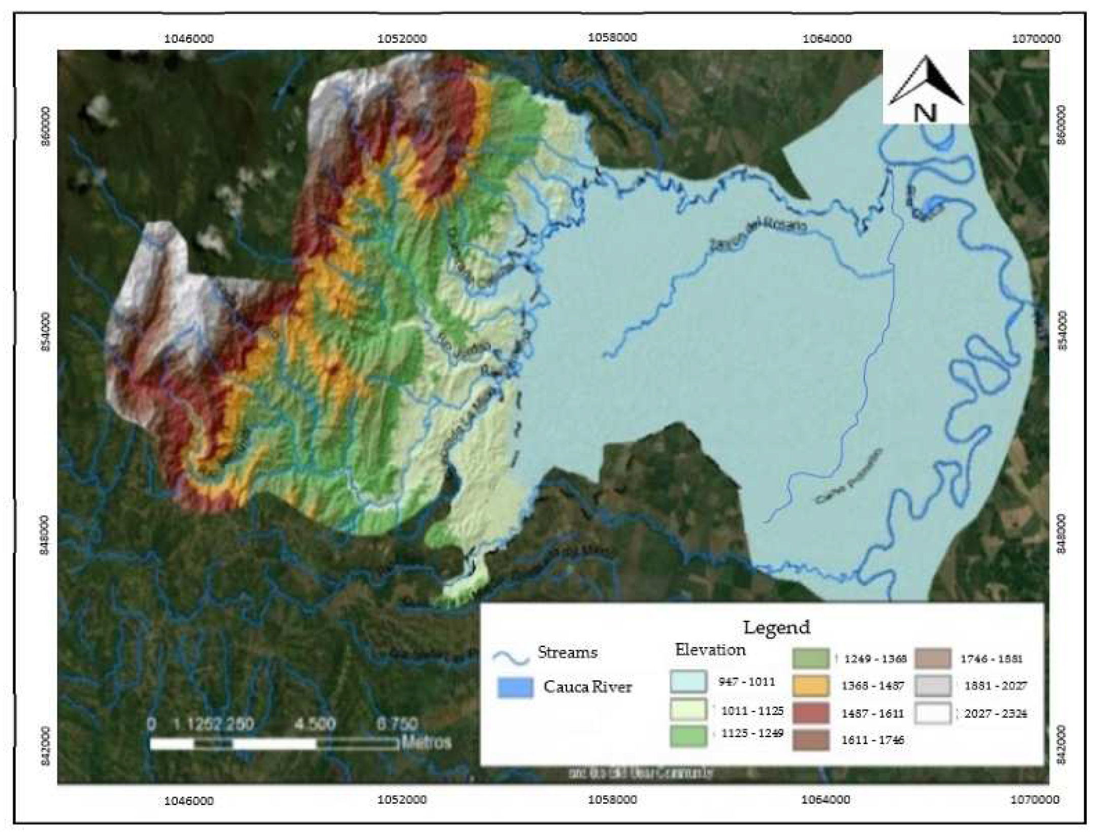
Two DEM of the study area were used, one at a scale of 1:25000 and the other at a scale of 1:2000. These DEM were generated using: cartographic information provided by the Colombian Geological Service; information taken with LIDAR technology by the CVC (regional environmental authority), which is available with a pixel size of 0.5, 1.0 and 2.5 m and centimeter vertical accuracy; information taken from the ALOS PALSAR satellite, which is available for the upper part of the basin with a pixel size of 12.5 m and submeter accuracy; high-precision GPS points located directly in the field; and, topobatimetric surveys of several channels in the Jamundí River basin.
Figure 3 shows the 1:2000 scale DEM used in the modeling.
4.2.2. Hydrological information
The hydrological information consisted of the hydrographs of the debris flows corresponding to the return periods defined in the methodology. These hydrographs were obtained by hydrological modeling performed using HEC-HMS software.
Figure 4 shows the hydrographs of several of the floods introduced at the upstream boundary of the model.
4.2.3. Sedimentological Information
The sedimentological information corresponded to the estimated volumes of sediments that can be mobilized during debris flow. These volumes can come from destabilization of slopes adjacent to the channel, from the pluvial erosion of the basin and from the erosion of the main channel.
Table 4 shows the sediment volumes calculated at the upstream boundaries for the event corresponding to the 500-year return period.
4.2.4. Rheological Characteristics of the Flow
It was established that debris flows in the Jamundí River basin have rheological characteristics similar to those of the mudflow of the Colorado Rocky Mountains (USA) near the city of Aspen – pit 1. Consequently, to calculate the values of the yield stress and the absolute viscosity of the flow, the same values of the empirical coefficients of this mudflow were adopted in this modeling, that is, the following values were used: α1 = 3.60 * 10-2 poises, α2 = 1.81 * 10-1 dynes/cm², β1 = 22.1 and β2 = 25.7 [
44].
4.3. Phase 1: Determination of the hazard in the rural area
The first step in determining this hazard is the implementation of a hydrodynamic model that allows analyzing the behavior of debris flows corresponding to different return periods. The modeling was carried out using the FLO2D software, since it is a model that takes into account the rheology of non-Newtonian flows, allows working with complex topographies and has the capacity to incorporate sediments from slopes and rockfalls.
The modeling was carried out using a DEM of the study area generated at a scale of 1:25000. A mesh size of 7 m was adopted, resulting in approximately one million cells. This cell size allowed obtaining an adequate accuracy of the results and a reasonable computational time. A Maning roughness value of 0.035 was defined for the Jamundí River, a value of 0.08 for forests and semi-natural areas and a value of 0.015 for artificial areas.
Debris flow corresponding to the return periods of 2.33, 5, 10, 25, 50, 75, 100, 200, 300, 400 and 500 years were modeled. Each of the simulations took approximately 20 hours. The results of these simulations allowed obtaining the variation of the depths and velocities of the flow in each of the pixels through which the territory was represented.
Figure 5 shows the maximum depths and velocities obtained for the debris flows with a return period of 500 years.
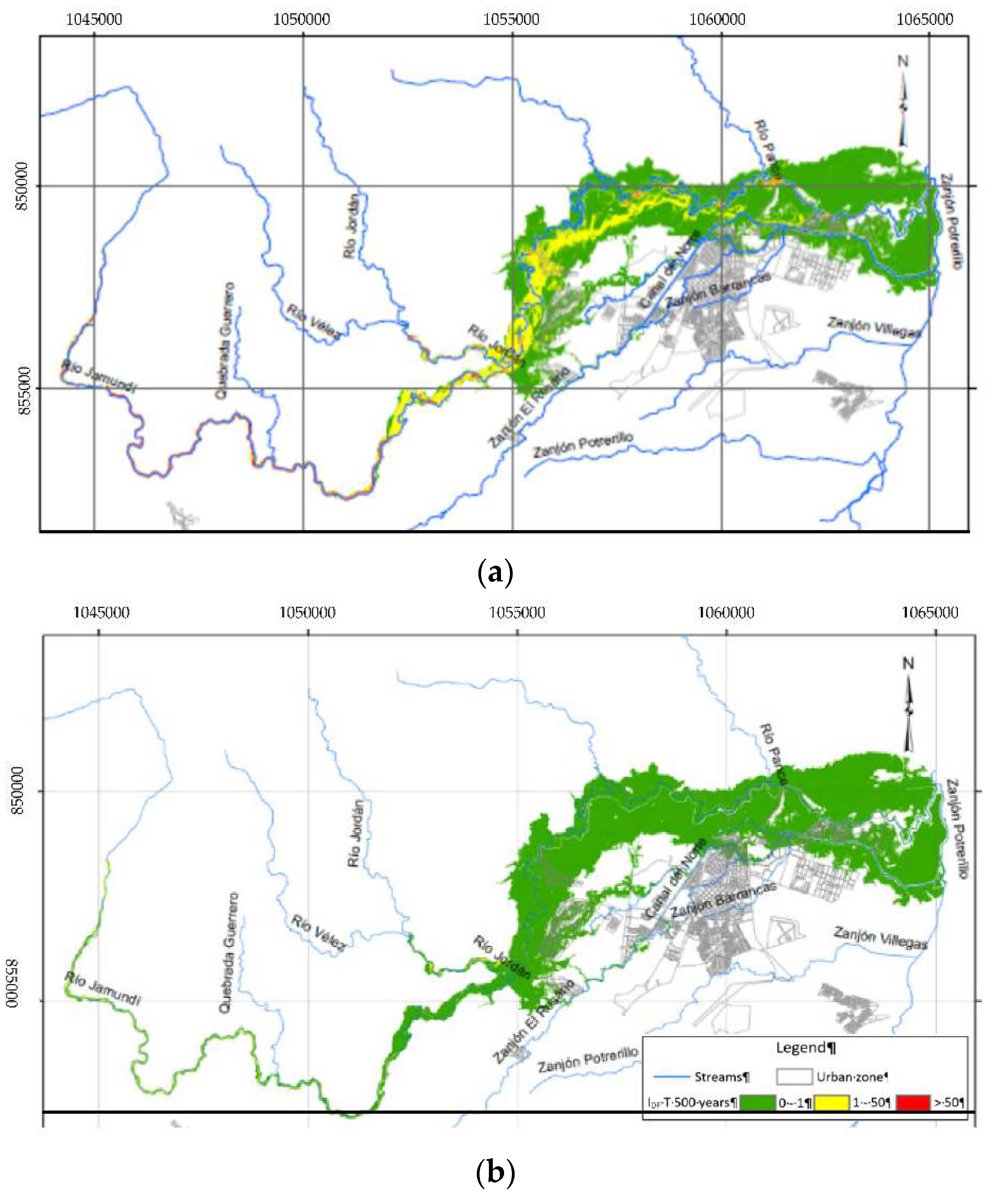
Using the results obtained through mathematical modeling and by means of equation 1, the I
DF values were calculated at each pixel for all modeled events.
Figure 6a shows the I
DF calculated for the event corresponding to the 500-year return period. Subsequently, by means of Equation 2, taking as T
min value the return period from which the flood begins and based on the I
DF obtained for each of the events analyzed, the combined I
DF value was obtained for each pixel.
Figure 6b shows combined I
DF calculated in the Jamundí River basin.
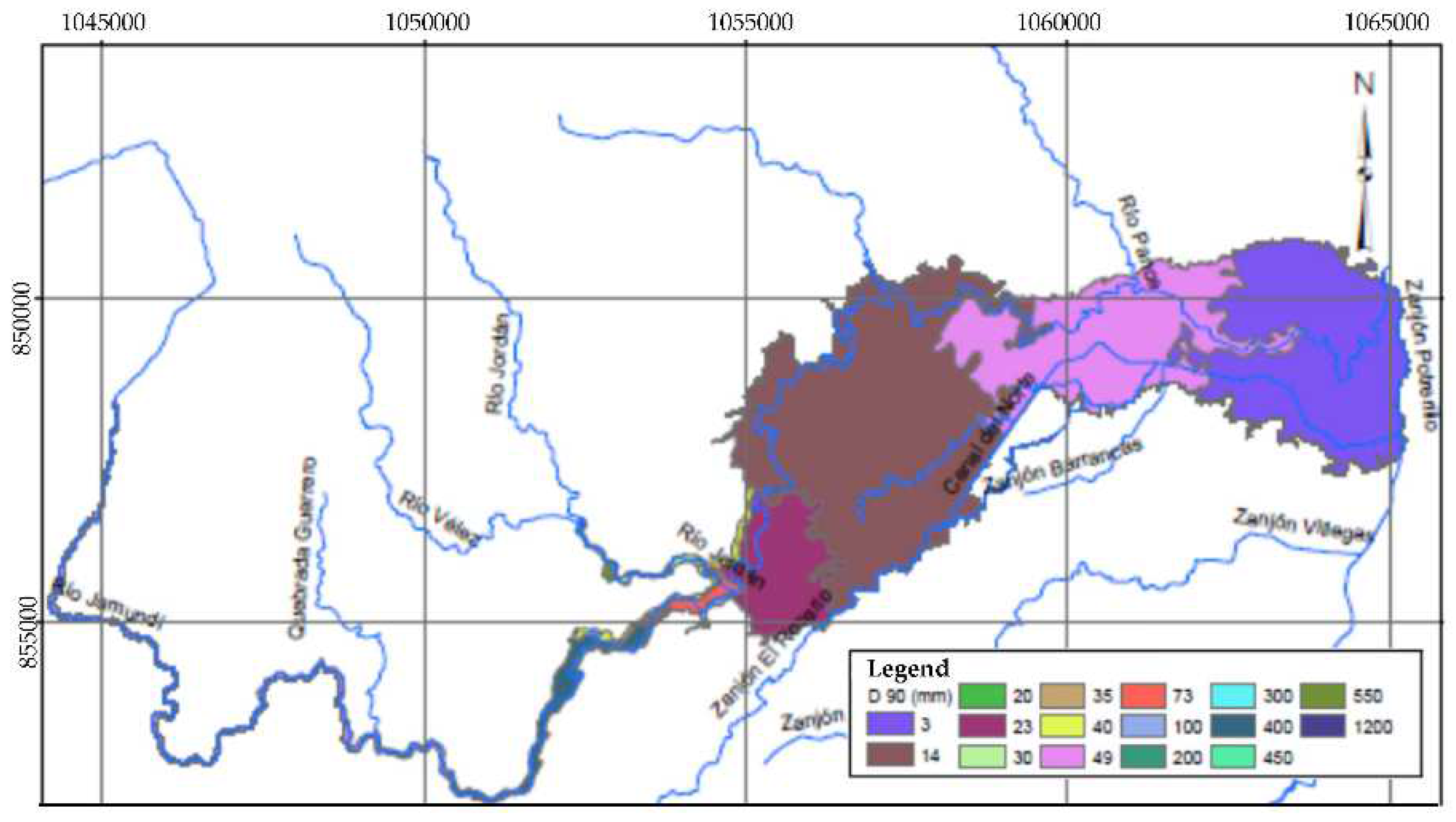
The next step is to determine the D
90 value of the sediments that could be mobilized by the debris flows. The spatial variation of the D
90 in the Jamundí river basin is shown in
Figure 7.
Finally, to calculate the hazard, the combined I
DF and D
90 values are integrated for each pixel, according to the criteria established in
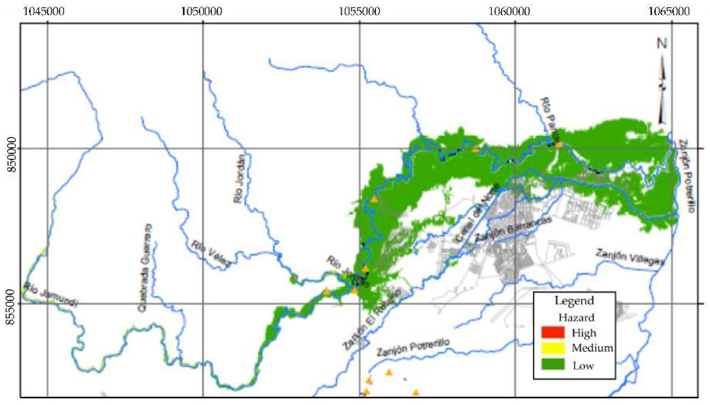
Table 1. This procedure allows to classify as high, medium or low the hazard in all points of the territory.
Figure 8 shows the zoning of the hazard due to debris flows in the Jamundí River watershed at a scale of 1:25000. According to the results obtained, almost the entire rural area of the watershed presents a low hazard level; Only a few small sectors restricted mainly to the watercourses present medium and high hazard levels.
4.4. Phase II: Determination of hazards in urban areas, urban expansion areas and areas classified as high and medium hazard in rural areas
Given that the results achieved in the analysis of the rural area indicated that in this sector the areas exposed to high or medium hazard are very small and mainly limited to the main channels, in this stage of the methodology the analysis focused on the zoning of the hazard in urban and urban expansion zones, which are located mainly in the lower part of the watershed.
For the mathematical modeling the Hec Ras model - Debris Flow module was used, which allows modeling non-Newtonian flows with high concentration of solids and calculating the corresponding internal losses by representing the flow through a single phase.
The modeling was carried out using a DEM at 1:2000 scale of the lower part of the watershed. In this sector the slopes are relatively low, so it is considered mainly as a deposit area for the material transported by the debris flows where erosion and sediment dragging phenomena will probably be of low magnitude. The same roughness and rheological properties of the flow established in the 1:25000 scale modeling were adopted. A cell size of 5 m and a time interval of 2 seconds were established, which guaranteed the stability of the modeling and allowed achieving sufficiently accurate results and reasonable computational times.
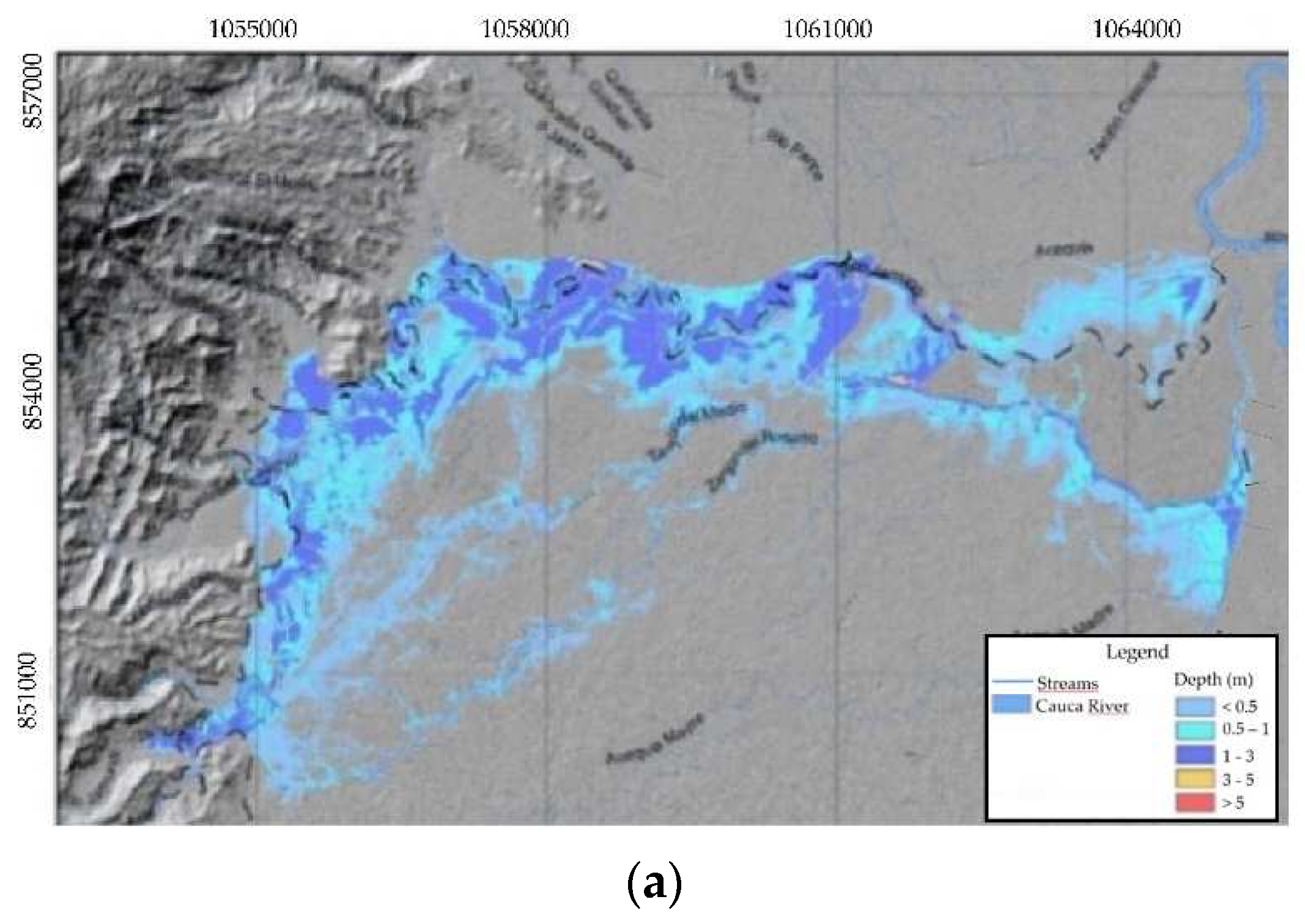
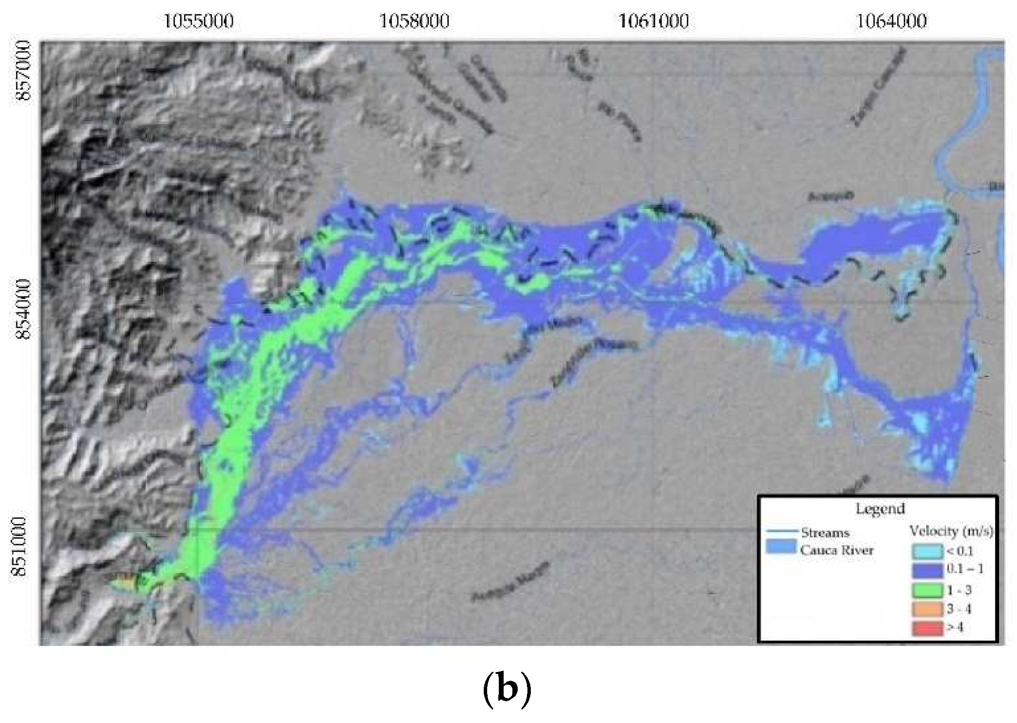
Mathematical modeling of eleven events corresponding to the return periods 2.33, 5, 10, 25, 50, 75, 100, 200, 300, 400 and 500 years was performed to establish the hazard curves in each of the flooded pixels. The simulation time for events with the highest return periods was around 14 hours.
Figure 9 shows the maximum depths and velocities corresponding to the debris flow with a return period of 500 years.
Based on the results obtained, the I
DF in the flooded pixels were calculated. From this information, for each pixel a hazard curve that relates the probability of occurrence of debris flow with its corresponding I
DF was interpolated, taking into account that in each pixel there are as many I
DF as events that flood it. A minimum number of 6 points was established to plot these curves. During the plotting of the curves, it was found that in most cases the best fit to the points obtained was reached with polynomial equations of degree 2.
Figure 10 shows a hazard curve obtained for one of the pixels of the Jamundí River basin.
In order to carry out the zoning of the territory, the impact of events with a high frequency of occurrence was initially determined. With this objective, based on the hazard curves, the return period that a debris flow with an I
DF of 5 m
3/s
2 would have was established. According to
Table 2, if this period is less than 30 years the hazard is classified as high, if it is between 30 and 100 years the hazard is medium and if it is greater than 100 years the hazard is low.
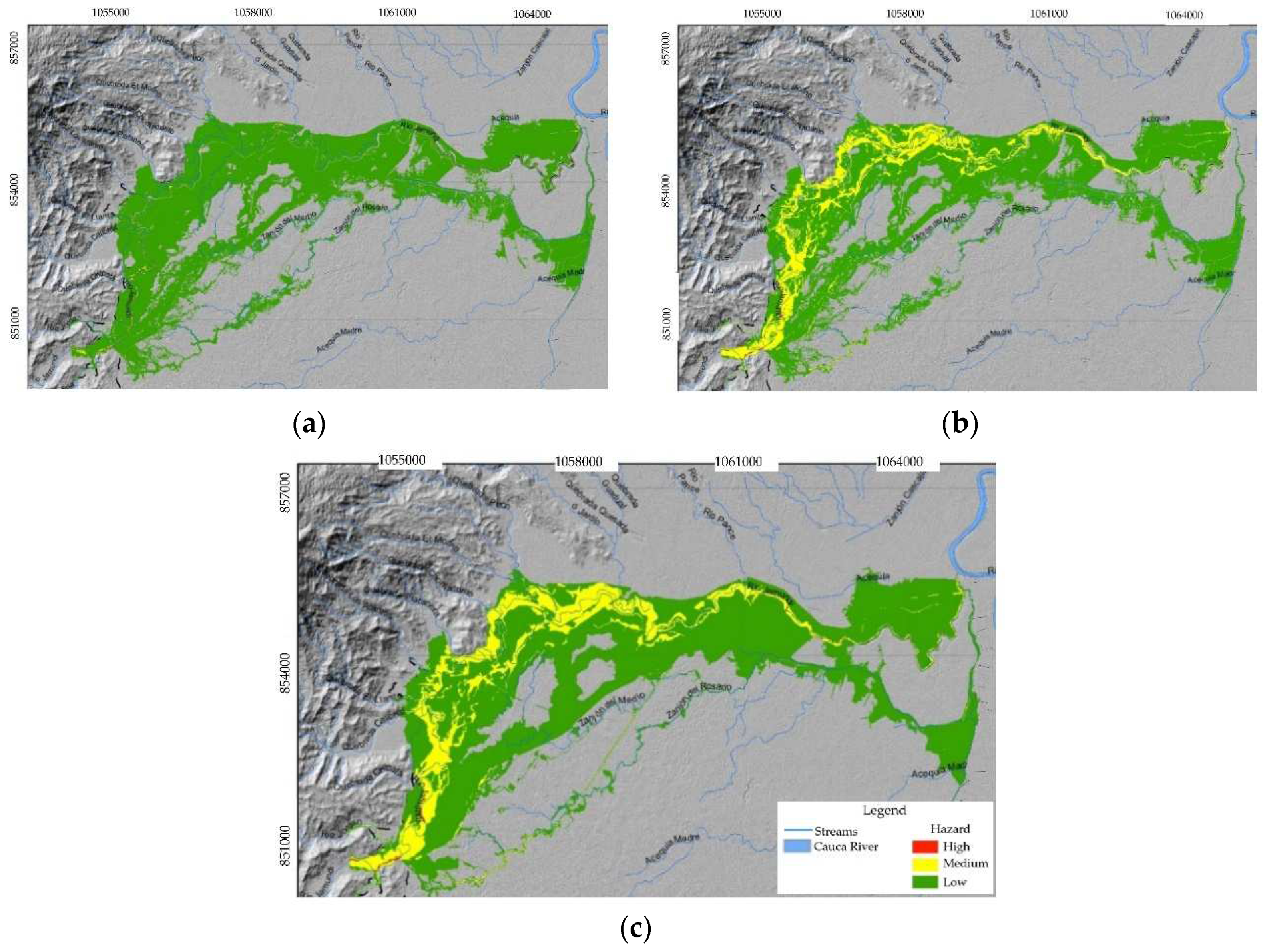
Figure 11a shows the hazard zoning considering this criterion.
Subsequently, the impact of events with a low frequency of occurrence was established, for which the value of the I
DF for the event with a return period of 500 years was determined. According to
Table 3, if this I
DF is less than 1 m
3/s
2 the hazard is low, if it is between 1 and 25 m
3/s
2 the hazard is medium and if it is greater than 25 m
3/s
2 the hazard is high.
Figure 11b shows the zoning of the territory considering this criterion.
The definitive hazard due to debris flows is obtained by aggregating the hazards obtained by considering the impact of frequent events and infrequent events. This aggregation consists of assigning to each pixel the highest level of hazard found.
Figure 11c shows the definitive zoning at scale 1:2000 of the hazard due to debris flows in the lower part of the Jamundí river basin. The results indicate that only some sections of the main channel in the upper part of the studied area present a high hazard, which represents a very low percentage of the total affected area. Approximately 25% of flooded area is subject to a medium hazard level and the remaining 75% present a low hazard.
5. Conclusions
This paper presents a new methodology for determining the hazard due to debris flows. This methodology takes into account all the relevant technical aspects in the generation of events of these characteristics, which is why it is considered that, from the technical point of view, it is rigorous, but at the same time simple to implement.
In this methodology, the hazard is classified as high, medium or low based on the granulometry of the sediments that could be incorporated into the flow and a Debris Flow Intensity Index, IDF, which is calculated from the maximum depths and velocities of debris flows corresponding to different return periods. The hydrodynamic characteristics of the flow must be estimated through mathematical modeling performed using models that consider the non-Newtonian flow rheology and the volumes of sediments that could be incorporated into the flow.
Initially the hazard in the rural area must be calculated using information at scale 1:25000 or lower and later, using information at scale 1:2000, the hazard must be determined in urban areas and urban projection areas as well as in rural areas classified as high or medium hazard in the analysis of the rural area.
The hazard classification is based on the reference values adopted for sediment size and for the Debris Flow Intensity Index, IDF, which is an empirical parameter. These values have been derived from the consequences of several debris flows around the world. In order to increase the level of certainty of the adopted values, it is necessary to expand and permanently update the number of events analyzed for the definition of the IDF and the sediment size. This greater certainty in the adopted reference values would allow increase the level of accuracy of the zoning of the territory.
The applicability of the methodology was determined through the implementation of a case study. The results obtained indicate that the areas exposed to a high hazard due to debris flow in the Jamundí River basin are very small, while approximately 85% of the areas that would be affected have a low hazard and the remaining 15% are exposed to a medium hazard level. Additionally, it is observed that in the Jamundí River basin the highest levels of hazard are generated by events with a low frequency of occurrence, since IDF would reach values that are associated with severe structural damage. Events with a high frequency of occurrence reach IDF values associated with structural damage considered relatively minor.
In order to achieve a comprehensive management of the risk generated by debris flows, it is advisable to integrate the results obtained through the implementation of this methodology with a geomorphological analysis. This analysis would allow to reconstruct the fluvio-torrential history of the territory, establish the geoforms indicative of deposits and identify the geomorphological and morphodynamic elements that favor the occurrence of fluvio-torrential events. This information could be used to stablish the geomorphological susceptibility to debris flows, which would allow refining the hazard classification. Additionally, the results of the geomorphological analysis can be used to calculate more accurately the input information to the mathematical models used to determine of the hydrodynamic characteristics of the debris flows.
The implementation of the methodology proposed in this paper allows to accurately identify the level of hazard of the territory due to debris flows. This knowledge can be very useful for environmental authorities and organizations in charge of territorial planning and civil protection, since it could be used in the design of plans and actions to mitigate the risk generated by events of these characteristics.
Data Availability Statement. Data are available by requirement.
Author Contributions
For research articles with several authors, a short paragraph specifying their individual contributions must be provided. The following statements should be used “Conceptualization, C.A.R., R.A.B., E.J.S.; methodology, R.A.B., C.A.R.; software, R.A.B., M.P.L.; validation, R.A.B., M.P.L.; formal analysis, R.A.B., C.A.R. E.J.S.; investigation, R.A.B., C.A.R. E.J.S.; resources, C.A.R. E.J.S.; data curation, C.A.R. E.J.S.; writing—original draft preparation, R.A.B.; writing—review and editing, C.A.R., E.J.S., R.A.B.; visualization E.J.S., G.L.R.; supervision, E.J.S., G.L.R. All authors have read and agreed to the published version of the manuscript.”
Funding
“This research was funded by the Colombian Ministry of Housing, City and Territory, the Colombian Geological Service and the University of Valle, through the Convenio Interadministra-tivo Nº 719 de 2020 and the Convenio Especial de Cooperación No. 033 de 2020”.
Conflicts of Interest
The authors declare no conflict of interest.
References
- Rickenmann, D.; Zimmermann, M. The 1987 debris flows in Switzerland: documentation and analyses. Geomorphology 1993, 8, 175–189. [Google Scholar] [CrossRef]
- Papathoma-Köhle, M.; Gems, B.; Sturm, M.; Fuchs, S. Matrices, curves and indicators: A review of approaches to assess physical vulnerability to debris flows. Earth Science Reviews 2017, 171, 272–288. [Google Scholar] [CrossRef]
- Bernard, M.; Gregoretti, C. The use of rain gauge measurements and radar data for the model-based prediction of runoff-generated debris-flow occurrence in early warning systems. Water Resour 2021, 57, 1–27. [Google Scholar] [CrossRef]
- Huang, Y.; Sun, J.; Zhu, C. Mechanism and Prevention of Debris Flow Disaster. Water 2022, 14, 1143. [Google Scholar] [CrossRef]
- Koutroulis, A.; Tsanis, I. A method for estimating flash flood peak discharge in a Poorly Gauged Basin: Case Study for the 13-14 January 1994 Flood, Giofiros Basin, Crete, Greece. Journal of Hydrology 2010, 385, 150–164. [Google Scholar] [CrossRef]
- Corominas, J.; van Westen, C.; Frattini, P.; Cascini, L.; Malet, J.P.; Fotopoulou, S.; Catani, F.; et al. Recommendations for the quantitative analysis of landslide risk. Bull. Eng. Geol. Environ. 2014, 73, 209–263. [Google Scholar] [CrossRef]
- Dowling, C.A.; Santi, P.M. Debris flows and their toll on human life: a global analysis of debris flow fatalities from 1950 to 2011. Nat Hazards 2014, 71, 203–227. [Google Scholar] [CrossRef]
- CRheinberger, M.; Romang, H.E.; Bründl, M. Proportional loss functions for debris flow events. Nat Hazards Earth Syst. Sci. 2013, 13, 2147–2156. [Google Scholar] [CrossRef]
- Aristizábal, E.; Arango, M.I.; Garcia, I.K. Definición y clasificación de las avenidas torrenciales y su impacto en los Andes colombianos. Cuadernos de Geografía: Revista Colombiana de Geografía 2020, 29, 242–258. [Google Scholar] [CrossRef]
- Wieczorek, G.F.; Larsen, M.C.; Eaton, L.S.; Morgan, B.A.; Blair, J. L Debris-flow and flooding hazards associated with the December 1999 storm in coastal Venezuela and strategies for mitigation. U.S. Geological Survey Open File Report 01-0144 2001, 1-31. Available online: https://pubs.usgs.gov/of/2001/ofr-01-0144/ (accessed on 14 July 2023).
- Imaizumi, F.; Osanai, N.; Kato, S.; Koike, M.; Kosugi, K.; Sakai, Y.; Sakaguchi, H.; Satofuka, Y.; Takayama, S.; Tanaka, T.; Nishi, Y. Debris flow disaster in Atami, Japan, in July 2021. Int J Erosion Cont Eng 2022, 15, 1–6. [Google Scholar] [CrossRef]
- Westra, S.; Fowler, H.J.; Evans, J.P.; Alexander, L.V.; Berg, P.; Johnson, F.; Kendon, E.J.; Lenderink, G.; Roberts, N.M. Future changes to the intensity and frequency of short-duration extreme rainfall. Rev. Geophys. 2014, 52, 522–555. [Google Scholar] [CrossRef]
- Chen, H.-W.; Chen, C.Y. Warning Models for Landslide and Channelized Debris Flow under Climate Change Conditions in Taiwan. Water 2022, 14, 695. [Google Scholar] [CrossRef]
- Cabral, V.C.; Reis, F.; Veloso, V.; Ogura, A.; Zarfl, C. A multi-step hazard assessment for debris-flow prone areas influenced by hydroclimatic events. Eng Geol 2023, 313, 1–20. [Google Scholar] [CrossRef]
- Nery, T.D. O uso de parametros morfometricos como potencial indicador a ocorrencia de fluxos de detritos no litoral norte de Sao Paulo. Geosul 2017, 179–200, 179–200. [Google Scholar] [CrossRef]
- Correa, C.V.S.; Reis, F.A.G.V.; Giordano, L.C.; Cabral, V.C.; Gramani, M.F.; Gabelini, B.M.; Duz, B.G.; Veloso, V.Q. Assessment of the potentiality to the debris-flow occurrence from physiographic and morphometrics parameters: a case study in Santo Antonio Basin (Caraguatatuba, Sao Paulo State, Brazil). Anu Inst Geocienc 2021, 44, 1–14. [Google Scholar] [CrossRef]
- Petracheck, A.; Kienholtz, H. Hazard assessment and mapping of mountains risks in Switzerland. In Debris flow hazards mitigation: mechanics, prediction, and assessment, 1st ed.; Rickenmann, D., Chen, C-L., Eds.; Millpress Science Publishers: Rotterdam, Netherlands, 2003; Volume 1, pp. 23–28. [Google Scholar]
- Chang, C.; Lin, P. Tsai C Estimation of sediment volume of debris flow caused by extreme rainfall in Taiwan. Eng Geol 2011, 123, 83–90. [Google Scholar] [CrossRef]
- Cabral, V.C.; Reis, F.A.G.V.; D’Affonseca, F.M.; Lucia, A.; dos Santos Correa, C.V.; Veloso, V.; Gramani, M.F.; Ogura, A.T.; Lazaretti, A.F.; Vemado, F.; Augusto Filho, J.P.; Correa, C.V.S.; Lopes, E.S.S.; Rabaco, L.M.R.; Giordano, L.C.; Zarfl, C. Characterization of a landslide-triggered debris flow at a rainforest-covered mountain region in Brazil. Nat Hazards 2021, 108, 3021–3043. [Google Scholar] [CrossRef]
- Veloso, V.Q.; Reis, F.A.V.G.; Cabral, V.; et al. Hazard assessment of debris-flow-prone watersheds in Cubatão, São Paulo State, Brazil. Nat Hazards 2023 116, 3119–3138. [CrossRef]
- Cabral, V.C.; Reis, F.A.G.V.; Mendoza, C.M.; Oliveira, A. Model-based assessment of shallow landslide susceptibility at a petrochemical site in Brazil. Rev. Brasil. Geomorfol. 2022, 23, 1394–1419. [Google Scholar] [CrossRef]
- Iverson, R.M.; Reid, M.E.; Logan, M.; LaHusen, R.G.; Godt, J.W.; Griswold, J.P. Positive feedback and momentum growth during debris-flow entrainment of wet bed sediment. Nat. Geosci. 2011, 4, 116–121. [Google Scholar] [CrossRef]
- Cao, C.; Zhang, W.; Chen, J.; Shan, B.; Song, S.; Zhan, J. Quantitative estimation of debris flow source materials by integrating multi-source data: A case study. Eng Geol 2021, 29, 1–13. [Google Scholar] [CrossRef]
- Hungr, O.; McDougall, S.; Bovis, M. Entrainment of material by debris flows. In Debris-flow Hazards and Related Phenomena. Springer Praxis Books, 1st ed.; Chen, C.-L., Major, J., J., *!!! REPLACE !!!*, Eds.; Springer: Berlin, Germany, 2005; Volume 1, pp. 135–158. [Google Scholar] [CrossRef]
- Santi, P.M.; Dewolfe, V.G.; Higgins, J.D.; Cannon, S.H.; Gartner, J.E. Sources of debris flow material in burned areas. Geomorphology 2008, 96, 310–321. [Google Scholar] [CrossRef]
- Hürlimann, M.; Rickenmann, D.; Graf, C. Field and monitoring data of debris-flow events in the Swiss Alps. Canadian Geotechnical Journal 2003, 40, 161–175. [Google Scholar] [CrossRef]
- Rickenmann, D. Runout prediction methods. In Debris-flow Hazards and Related Phenomena. Springer Praxis Books, 1st ed.; Chen, C.-L., Major, J., J., *!!! REPLACE !!!*, Eds.; Springer: Berlin, Germany, 2005; Volume 1, pp. 305–321. [Google Scholar] [CrossRef]
- What is a landslide and what causes one? Available online: https://www.usgs.gov/faqs/what-a-landslide-and-what-causes-one?qt-news_science_products=0#qt-news_science_products. (accessed on 4 July 2023).
- Yang, Z.; Wang, L.; Qiao, J.; Uchimura, T.; Wang, L. Application and verification of a multivariate real-time early warning method for rainfall-induced landslides: implication for evolution of landslide-generated debris flows. Landslides 2020, 17, 2409–2419. [Google Scholar] [CrossRef]
- Hsu, Y.-C.; Liu, K.-F. Combining TRIGRS and DEBRIS-2D Models for the Simulation of a Rainfall Infiltration Induced Shallow Landslide and Subsequent Debris Flow. Water 2019, 11, 890. [Google Scholar] [CrossRef]
- Zanchetta, G.; Sulpizio, R.; Pareschi, M.T.; Leoni, F.M.; Santacroce, R. Characteristics of May 5–6, 1998 volcaniclastic debris flows in the Sarno area. Journal of Volcanology and Geothermal Research 2004, 133, 377–393. [Google Scholar] [CrossRef]
- Jakob, M.; Stein, D.; Ulmi, M. Vulnerability of buildings to debris flow impact. Nat Hazards 2012, 60, 241–261. [Google Scholar] [CrossRef]
- Ramos, A.M.; Reyes, A.A.; Munevar, M.A.; Ruiz, G.L.; Machuca, S.V.; Rangel, M.S.; Prada, L.F.; Cabrera, M.A.; Rodríguez, C.E.; Escobar, N.; Quintero, C.A.; Escobar, J.A.; Giraldo, J.D.; Medina, M.S.; Duran, L.; Trujillo, D.E.; Medina, D.F.; Capachero, C.A.; León, D.; Ramírez, K.C.; Pérez, M.A. Guía metodológica para zonificación de amenaza por avenidas torrenciales. Servicio Geológico Colombiano y Pontificia Universidad Javeriana 2021.
- Bocanegra, R.A.; Francés, F. Assessing the risk of vehicle instability due to flooding. Journal of Flood Risk Management 2021, 14, 1–15. [Google Scholar] [CrossRef]
- Bardou, E.; Ancey, C.; Bonnard, C.; Vulliet, L. Classification of debris-flow deposits for hazard assessment in alpine areas. In Proceedings of the 3th International Conference on Debris-Flow Hazards Mitigation: Mechanics, Prediction, and Assessment, Davos, Switzerland, 10–12 September 2003; Available online: http://infoscience.epfl.ch/record/94551.
- He, S.; Liu, W.; Li, X. Prediction of impact force of debris flow based on distribution and size of particles. Environmental Earth Sciences 2016, 75, 298–305. [Google Scholar] [CrossRef]
- Cui, Y.; Choi, C.E.; Liu, L.H.D.; Ng, C.W.W. Effects of particle size of mono-disperse granular flows impacting a rigid barrier. Nat. Hazards 2018, 91, 1179–1201. [Google Scholar] [CrossRef]
- Liang, Y.; Xiong, F. Quantification of debris flow vulnerability of typical bridge substructure based on impact force simulation. Geomatics, Natural Hazards and Risk 2019, 10, 1839–1862. [Google Scholar] [CrossRef]
- Chehade, R.; Chevalier, B.; Dedecker, F.; Breul, P.; Thouret, J.-C. Effect of Boulder Size on Debris Flow Impact Pressure Using a CFD-DEM Numerical Model. Geosciences 2022, 12, 1–12. [Google Scholar] [CrossRef]
- De Hass, T.; y van Woerkom, T. Bed scour by debris flows: experimental investigation of effects of debris-flow composition. Earth Surface Processes and Landforms 2016, 41, 1951–1966. [Google Scholar] [CrossRef]
- Corporación Autónoma Regional del Valle del Cauca - Universidad del Valle. Caracterización de los Ríos Tributarios del Río Cauca - Tramo Salvajina - La Virginia 2000. Santiago de Cali, Colombia.
- Departamento Administrativo Nacional de Estadística (DANE). La Información del DANE: Candelaria, Jamundí, Palmira, Yumbo – Valle del Cauca 2020.
- Servicio Geológico Colombiano - Universidad del Valle. Zonificación de amenaza por avenidas torrenciales en Jamundí departamento del Valle del Cauca a escala 1:2000 2021.
- O'Brien, J.S.; Julien, P.Y. Physical properties and mechanics of Hyperconcentrated sediment flows In Proceedings of the Delineation of Landslides, Flash Flood, and Debris Flow Hazards, Utah, United States, June 1984.
|
Disclaimer/Publisher’s Note: The statements, opinions and data contained in all publications are solely those of the individual author(s) and contributor(s) and not of MDPI and/or the editor(s). MDPI and/or the editor(s) disclaim responsibility for any injury to people or property resulting from any ideas, methods, instructions or products referred to in the content. |
© 2023 by the authors. Licensee MDPI, Basel, Switzerland. This article is an open access article distributed under the terms and conditions of the Creative Commons Attribution (CC BY) license (http://creativecommons.org/licenses/by/4.0/).
