Submitted:
03 September 2023
Posted:
06 September 2023
You are already at the latest version
Abstract
Keywords:
1. Introduction
2. Materials and Methods
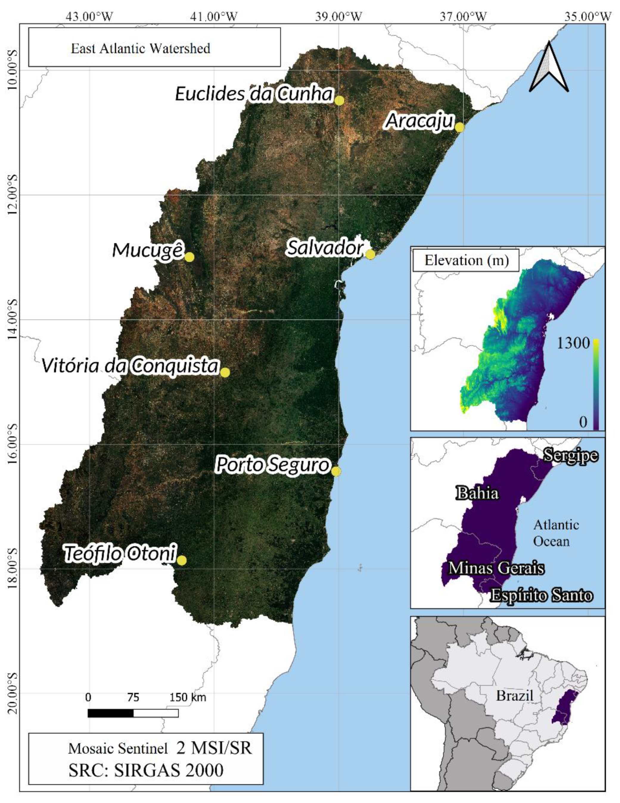
2.1. Study site and database
2.2. The MEDALUS model
| Susceptibility | Weights | Subclasses |
| Not affected | < 1.170 | No |
| potentially affected | 1.170 - 1.225 | P |
| Fragile | 1.225 - 1.275 | F1 |
| 1.275 - 1.325 | F2 | |
| 1.325 - 1.375 | F3 | |
| Critical | 1.375 - 1.425 | C1 |
| 1.425 - 1.530 | C2 | |
| > 1.530 | C3 |
2.3. Quality scores
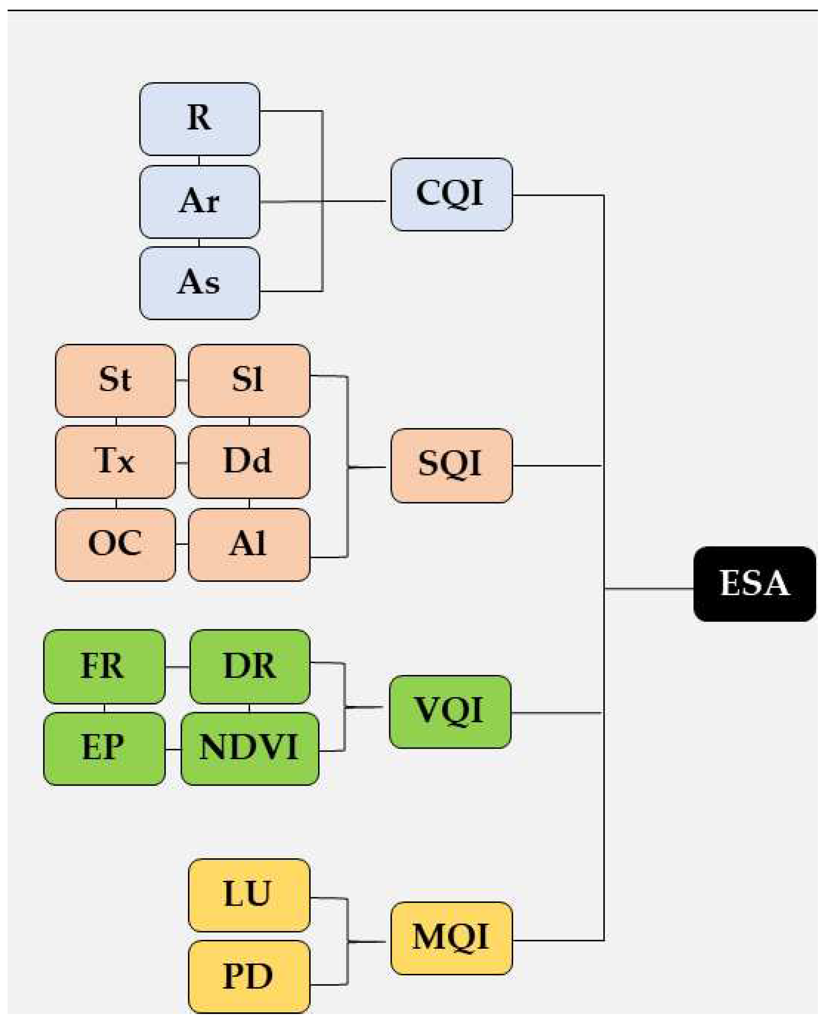
2.4. Statistical analysis
3. Results
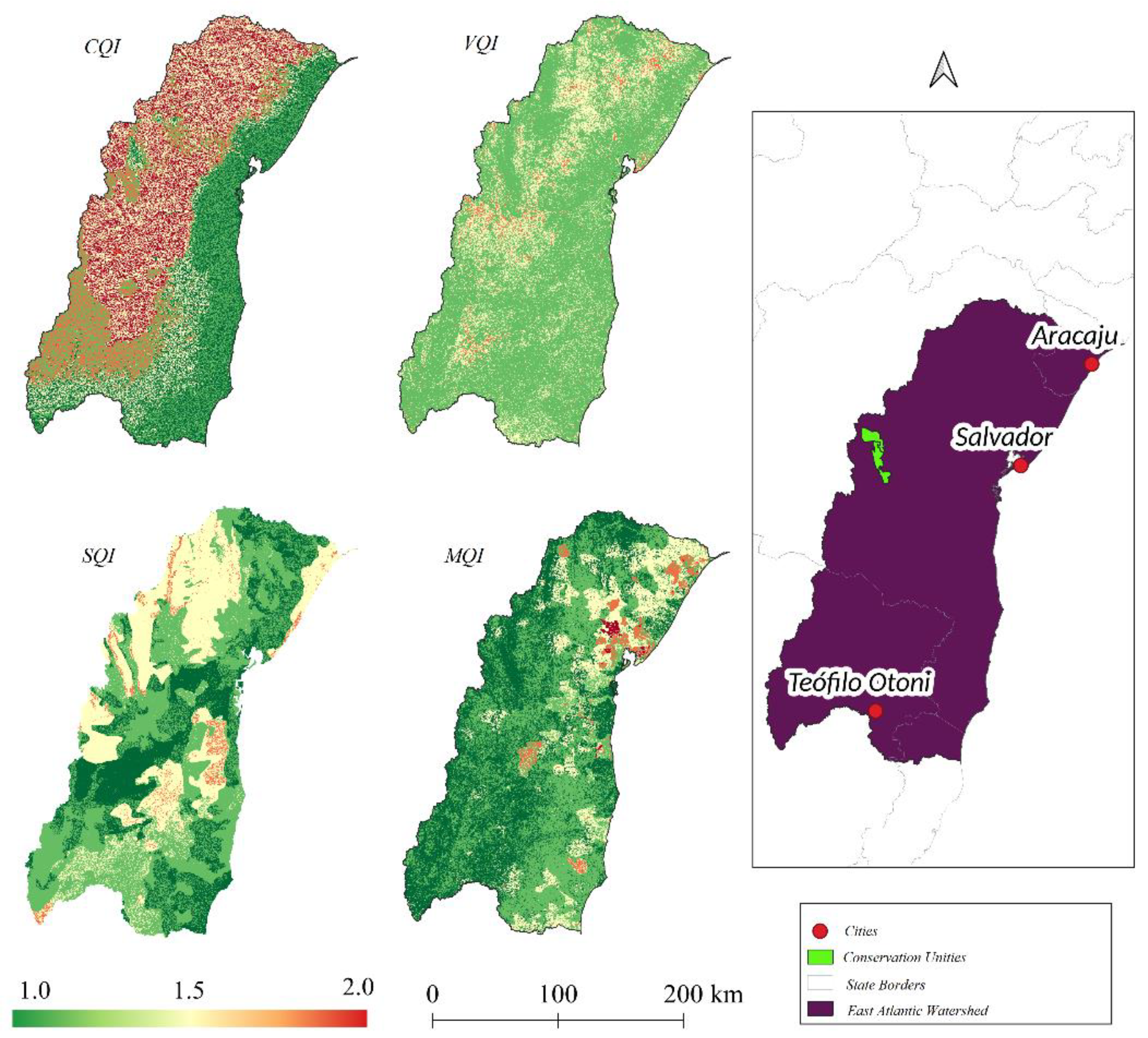
3.1. Quality scores
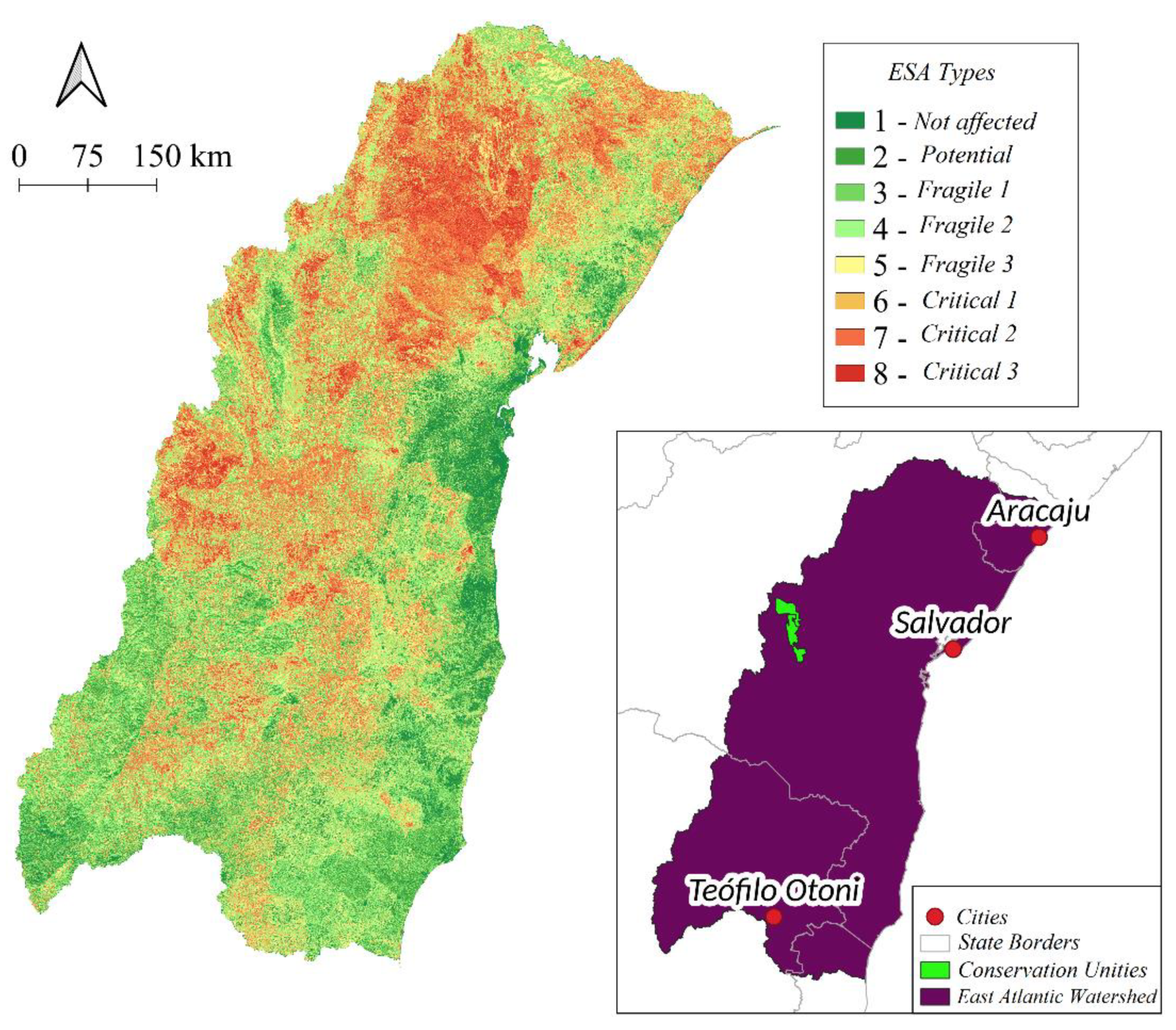
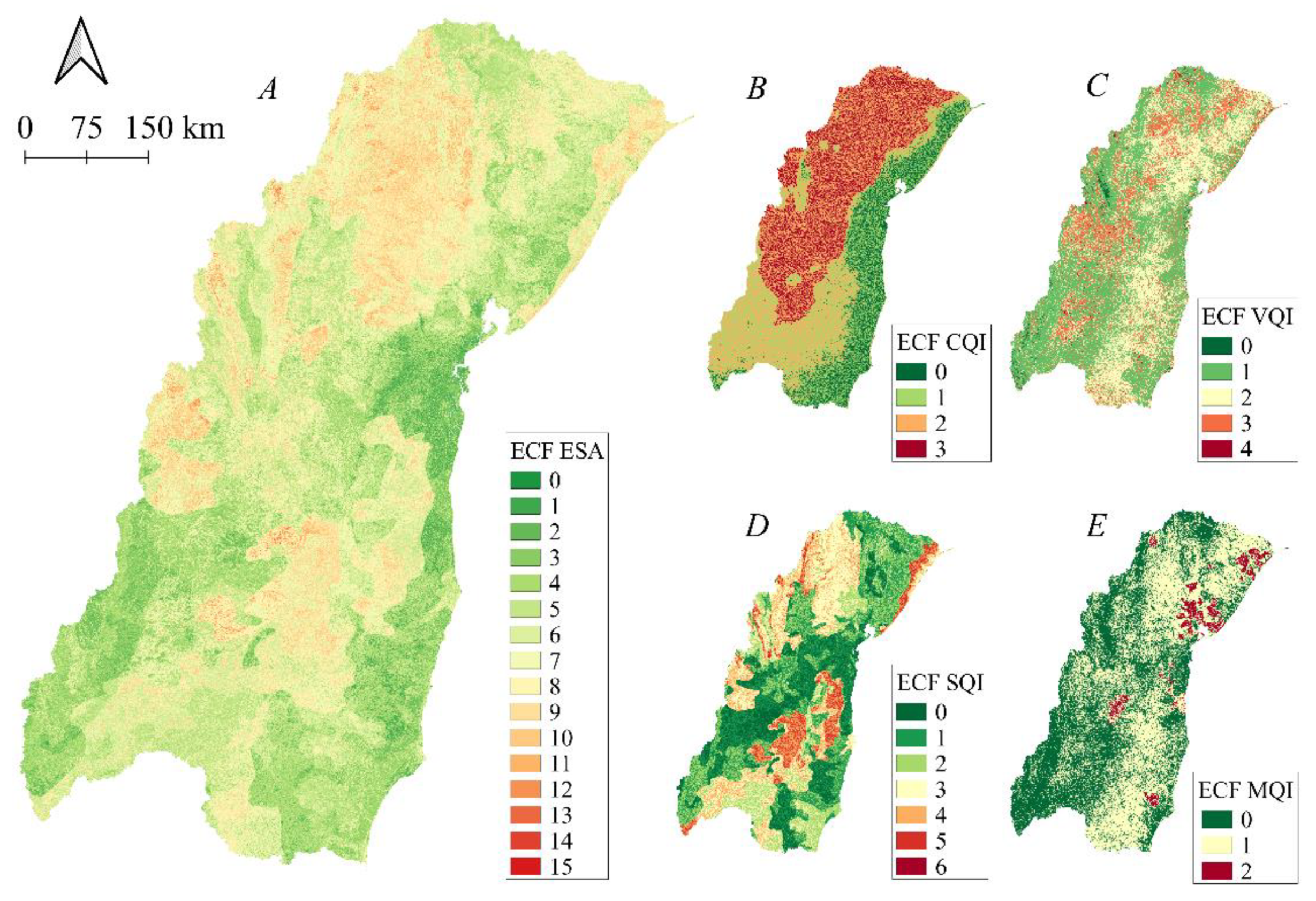
3.2. Environmentally Sensitive Area (ESA)
| Susceptibility | Weights | Subclasses | Area (km²) | Area (%) |
| Not affected | < 1.170 | No | 19177.49 | 5.0% |
| potentially affected | 1.170 - 1.225 | P | 38883.42 | 10.1% |
| Fragile | 1.225 - 1.275 | F1 | 56033.22 | 14.5% |
| 1.275 - 1.325 | F2 | 68675.25 | 17.8% | |
| 1.325 - 1.375 | F3 | 65941.47 | 17.1% | |
| Critical | 1.375 - 1.425 | C1 | 54968.20 | 14.2% |
| 1.425 - 1.530 | C2 | 70176.42 | 18.2% | |
| > 1.530 | C3 | 12656.84 | 3.3% |
4. Discussion
4.1. Environmentally Sensitive Areas (ESAs)
5. Conclusions
Supplementary Materials
Author Contributions
Funding
Data Availability Statement
Conflicts of Interest
References
- Liu, Z.; Si, J.; Deng, Y.; Jia, B.; Li, X.; He, X.; Zhou, D.; Wang, C.; Zhu, X.; Qin, J.; Ndayambaza, B.; Wang, B. Assessment of land desertification and its drivers in semi-arid alpine mountains: a case study of Qilian Mountains Region, northwest China. Remote Sens. 2023, 15. [Google Scholar] [CrossRef]
- Wijitkosum, S. Reducing Vulnerability to Desertification by Using the Spatial Measures in a Degraded Area in Thailand. Land 2020, 9, 49. [Google Scholar] [CrossRef]
- Ren, Y.; Liu, X.; Zhang, B.; Chen, X. Sensitivity assessment of land desertification in China based on multi-source remote sensing. Remote Sens. 2023, 15, 2674. [Google Scholar] [CrossRef]
- Bakr, N.; Weindorf, D. C.; Bahnassy, M. H.; El-Badawi, M. M. Multi-temporal assessment of land sensitivity to desertification in a fragile agro-ecosystem: Environmental indicators. Ecol. Indic. 2012, 15, 271–280. [Google Scholar] [CrossRef]
- Djeddaoui, F.; Chadli, M.; Gloaguen, R. Desertification susceptibility mapping using logistic regression analysis in the Djelfa area, Algeria. Remote Sens. 2017, 9, 1031. [Google Scholar] [CrossRef]
- Wang, W.; Jiang, Y.; Wang, G.; Guo, F.; Li, Z.; Liu, B. Multi-Scale LBP texture feature learning network for remote sensing interpretation of land desertification. Remote Sens. 2022, 14, 348. [Google Scholar] [CrossRef]
- Xu, D.; You, X.; Xia, C. Assessing the spatial-temporal pattern and evolution of areas sensitive to land desertification in North China. Ecol. Indic. 2019, 97, 150–158. [Google Scholar] [CrossRef]
- Meza Mori, G.; Torres Guzmán, C.; Oliva-Cruz, M.; Salas López, R.; Marlo, G.; Barboza, E. Spatial Analysis of Environmentally Sensitive Areas to Soil Degradation Using MEDALUS Model and GIS in Amazonas (Peru): An Alternative for Ecological Restoration. Sustainability 2022, 14, 14866. [Google Scholar] [CrossRef]
- Abuzaid, A. S.; Abdelatif, A. D. Assessment of desertification using modified MEDALUS model in north Nile Delta, Egypt. Geoderma 2022, 405, 115400. [Google Scholar] [CrossRef]
- Lahlaoi, H.; Rhinane, Hilali, A. ; Lahssini, S.; Moukrim, S. Desertification assessment using MEDALUS model in watershed Oued El Maleh, Morocco. Geosciences 2017, 7, 50. [Google Scholar] [CrossRef]
- Kosmas, C.; Ferrara, A.; Briassouli, H.; Imeson, A. Methodology for Mapping Environmentally Sensitive Areas (ESAs) to Desertification; European Commission: Luxembourg. 1999. [Google Scholar]
- Wijitkosum, S. The impact of land use and spatial changes on desertification risk in degraded areas in Thailand. Sustainable Environment Research 2016, 26, 84–92. [Google Scholar] [CrossRef]
- Vieira, R. M. S. P.; Tomasella, J.; Alvalá, R. C. S.; Sestini, M. F.; Affonso, A. G.; Rodriguez, D. A.; Barbosa, A. A.; Cunha, A. P. M. A.; Valles, G. F.; Crepani, E.; de Oliveira, S. B. P.; de Souza, M. S. B.; Calil, P. M.; de Carvalho, M. A.; Valeriano, D. M.; Campello, F. C. B.; Santana, M. O. Identifying areas susceptible to desertification in the Brazilian northeast. Solid Earth 2015, 6, 347–360. [Google Scholar] [CrossRef]
- Tomasella, J.; Vieira, R. M. S. P.; Barbosa, A. A.; Rodriguez, D. A.; Santana, M. O.; Sestini, M. S. Desertification trends in the Northeast of Brazil over the period 2000-2016. Int J Appl Earth Obs Geoinformation 2018, 73, 197–206. [Google Scholar] [CrossRef]
- Chen, R.; Yang, H.; Yang, G.; Liu, Y.; Zhang, C.; Long, H.; Xu, H.; Meng, Y.; Feng, H. Land-Use Mapping with Multi-Temporal Sentinel Images Based on Google Earth Engine in Southern Xinjiang Uygur Autonomous Region, China. Remote Sens. 2023, 15, 3958. [Google Scholar] [CrossRef]
- Souza, C.M., Jr.; Z. Shimbo, J.; Rosa, M.R.; Parente, L.L.; A. Alencar, A.; Rudorff, B.F.T.; Hasenack, H.; Matsumoto, M.; G. Ferreira, L.; Souza-Filho, P.W.M.; et al. Reconstructing Three Decades of Land Use and Land Cover Changes in Brazilian Biomes with Landsat Archive and Earth Engine. Remote Sens. 2020, 12, 2735. [Google Scholar] [CrossRef]
- Kadri, N.; Jebari, S.; Augusseau, X.; Mahdhi, N.; Lestrelin, G.; Berndtsson, R. Analysis of Four Decades of Land Use and Land Cover Change in Semiarid Tunisia Using Google Earth Engine. Remote Sens. 2023, 15, 3257. [Google Scholar] [CrossRef]
- Velastegui-Montoya, A.; Montalván-Burbano, N.; Carrión-Mero, P.; Rivera-Torres, H.; Sadeck, L.; Adami, M. Google Earth Engine: A Global Analysis and Future Trends. Remote Sens. 2023, 15, 3675. [Google Scholar] [CrossRef]
- Gorelick, N.; Hancher, M.; Dixon, M.; Ilyushchenko, S.; Thau, D.; Moore, R. Google Earth Engine: Planetary-scale geospatial analysis for everyone. Remote sensing of Environment 2017, 202, 18–27. [Google Scholar] [CrossRef]
- Santos, L.S.; Mendes, L.A. Influence of the Equatorial Pacific Ocean Temperature Oscillation on the Precipitation Regime of the East Atlantic Hydrographic Region. Brazilian Journal of Physical Geography 2020, 13, 1502–1518. [Google Scholar] [CrossRef]
- Brasil. Ministry of the Environment. East Atlantic Hydrographic Region Notebook. Brasília: Ministry of Health, 2006.
- Karamesouti, M. , Panagos, P., Kosmas, C. Model-based spatio-temporal analysis of land desertification risk in Greece. Catena 2018, 167, 266–275. [Google Scholar] [CrossRef]
- Abatzoglou, J.T.; Dobrowski, S. Z.; Parks, S. A.; Hegewisch, K. C. TerraClimate, a high-resolution global dataset of monthly climate and climatic water balance from 1958–2015. Scientific data 2018, 5, 170191. [Google Scholar] [CrossRef]
- United Nations Organization for Education, Science and Culture. Map of the world distribution of arid regions: Explanatory note. Paris: Unesco, 1979.
- FAO/IIASA/ISRIC/ISSCAS/JRC. Harmonized world soil database (version 1.2). Rome, Italy and IIASA, Laxenburg, Austria: FAO, 2012.
- Bonafoni, S.; Sekertekin, A. Albedo Retrieval from Sentinel-2 by New Narrow-to-Broadband Conversion Coefficients. IEEE Geoscience and Remote Sensing Letters 2020, 17, 618–1622. [Google Scholar] [CrossRef]
- Ferrara, A.; Kosmas, C.; Salvati, L.; Padula, A.; Mancino, G.; Nolè, A. Updating the MEDALUS-ESA Framework for Worldwide Land Degradation and Desertification Assessment. Land Degradation & Development 2020, 31, 1593–1607. [Google Scholar] [CrossRef]
- Lamqadem, A. A.; Pradhan, B.; Saber, H.; Rahimi, A. Desertification sensitivity analysis using Medalus model and GIS: a case study of the oases of middle draa valley, Marocco. Sensors 2018, 18, 2230. [Google Scholar] [CrossRef] [PubMed]
- Lahlaoi, H. ; Rhinane, Hilali, A.; Lahssini, S.; Moukrim, S. Desertification assessment using MEDALUS model in watershed Oued El Maleh, Morocco. Geosciences 2017, 7, 50. [Google Scholar] [CrossRef]
- Cunha, J.; Nóbrega, R. L. B.; Rufino, I.; Erasmi, S.; Galvão, C.; Valente, F. Surface albedo as a proxy for land-cover clearing in seasonally dry forests: evidence from the Brazilian Caatinga. Remote Sensing of Environment 2020, 238, 111250. [Google Scholar] [CrossRef]
- Nabiollahi, K.; Golmohamadi, F.; Taghizadeh-Mehrjardi, R.; Kerry, R.; Davari, M. Assessing the effects of slope gradient and land use change on soil quality degradation through digital mapping of soil quality indices and soil loss rate. Geoderma 2018, 318, 16–28. [Google Scholar] [CrossRef]
- Vieira, R.M.S.P.; Cunha, A. P. M. A.; Alvalá, R. C. S.; Carvalho, V. C.; Ferraz Neto, S. . Sestini, M. S. Land use and land cover map of a semiarid region of Brazil for meteorological and climatic models. Brazilian Journal of Meteorology 2013, 28, 129–138. [Google Scholar] [CrossRef]
- Mallick, J.; AlMesfer, M.K.; Singh, V.P.; Falqi, I.I.; Singh, C.K.; Alsubih, M.; Kahla, N.B. Evaluating the NDVI–Rainfall Relationship in Bisha Watershed, Saudi Arabia Using Non-Stationary Modeling Technique. Atmosphere 2021, 12, 593. [Google Scholar] [CrossRef]
- Silva, R.M.; Santos, C. A. G.; Maranhão, K. U. A.; Lima, R. F. P. Geospatial assessment of eco-environmental changes in desertification area of the Brazilian semi-arid region. Earth Sciences Research Journal 2018, 22, 175–186. [Google Scholar] [CrossRef]
- Fokeng, R. M.; Fogwe, Z. N. Landsat NDVI-based vegetation degradation dynamics and its response to rainfall variability and anthropogenic stressors in Southern Bui Plateau, Cameron. Geosystem and Geoenvironment 2020, 1, 100075. [Google Scholar] [CrossRef]
- Lee, E.; Piao, D.; Song, C.; Kim, J.; Lim, C. H.; Kim, E. Assessing environmentally sensitive land to desertification using MEDALUS method in Mongolia. Forest Science and Technology 2019, 15, 210–220. [Google Scholar] [CrossRef]
- Budak, M.; Günal, H.; Çelik, I.; Yildiz, H.; Acir, N.; Acar, M. Environmental sensitivity to desertification in northern Mesopotamia; application of modified MEDALUS by using analytical hierarchy process. Arabian Journal of Geosciences 2018, 11, 481. [Google Scholar] [CrossRef]
- Dutra, J. D.; Elmiro, M. A. T.; Garcia, R. A. Comparative analysis of methods applied in vegetation cover delimitation using Landsat 8 images. Soc. Nat. 2020, 32, 699–710. [Google Scholar] [CrossRef]
- Liu, S.; Wang, T.; Kang, W.; David, M. Several challenges in monitoring and assessing desertification. Environmental Earth Sciences 2015, 73, 7561–7570. [Google Scholar] [CrossRef]
- Chen, R.; Yang, H.; Yang, G.; Liu, Y.; Zhang, C.; Long, H.; Xu, H.; Meng, Y.; Feng, H. Land-Use Mapping with Multi-Temporal Sentinel Images Based on Google Earth Engine in Southern Xinjiang Uygur Autonomous Region, China. Remote Sens. 2023, 15, 3958. [Google Scholar] [CrossRef]
| Description | Fire risk | Drought Resistance | Erosion Protection | Land Use Intensity | Drainage Quality | Weight | |
|---|---|---|---|---|---|---|---|
| Forest Training | 1.7 | 1.1 | 1.0 | 1.0 | Excessive | 2.0 | |
| Savanna Formation | 1.8 | 1.1 | 1.2 | 1.0 | Slightly Excessive | 1.7 | |
| Mangrove | 1.2 | 1.0 | 1.1 | 1.0 | Imperfect | 1.4 | |
| Planted Forest | 1.8 | 1.2 | 1.2 | 1.4 | Moderately good | 1.2 | |
| Flooded Field and Swampy Area | 1.2 | 1.0 | 1.2 | 1.0 | Good | 1.0 | |
| Field Training | 1.3 | 1.4 | 1.3 | 1.1 | |||
| Other Non-Forest Formations | 1.5 | 1.5 | 1.4 | 1.1 | |||
| Pasture | 1.5 | 1.6 | 1.4 | 1.7 | NDVI | Weight | |
| Cane | 1.6 | 1.5 | 1.5 | 1.5 | < 0.25 | 2.0 | |
| Mosaic of Agriculture and Pasture | 1.5 | 1.6 | 1.6 | 1.5 | 0.25 - 0.32 | 1.8 | |
| Beach and Dune | 1.0 | 2.0 | 2.0 | 2.0 | 0.32 - 0.40 | 1.5 | |
| Urban Infrastructure | 1.0 | 2.0 | 2.0 | 2.0 | 0.40 - 0.50 | 1.3 | |
| Other Non-Vegetated Areas | 1.0 | 2.0 | 2.0 | 2.0 | > 0.50 | 1.0 | |
| Not observed | 1.0 | 1.0 | 1.0 | 1.0 | |||
| Rocky Formation | 1.0 | 2.0 | 1.0 | 1.0 | |||
| Mining | 1.0 | 2.0 | 2.0 | 2.0 | Demography (inhab/ha) | Weight | |
| Aquaculture | 1.0 | 1.0 | 1.8 | 2.0 | > 400 | 2.0 | |
| Apicum | 1.0 | 1.5 | 1.7 | 1.3 | 400 - 200 | 1.8 | |
| River, Lake, and Ocean | 1.0 | 1.0 | 2.0 | 1.0 | 200 - 100 | 1.6 | |
| Perennial Crop | 1.5 | 1.4 | 1.3 | 1.5 | 100 - 50 | 1.4 | |
| Soybean | 1.4 | 1.7 | 1.6 | 1.7 | 50 - 25 | 1.2 | |
| Other Temporary Crops | 1.3 | 1.5 | 1.7 | 1.6 | < 25 | 1.0 | |
| Soil type | Weight | Precipitation | Weight | ||||
| Rocks, Luvisols, Planosols | 2.0 | < 280 | 2.0 | Carbon Content | Weight | ||
| Argisols, Gleissolos, Neosols | 1.7 | 280 - 650 | 1.5 | < 0.2 | 2.0 | ||
| Cambisols, Chernosols, Spodosols | 1.3 | > 650 | 1.0 | 0.2 - 0.6 | 1.5 | ||
| Oxisols, Vertisols | 1.0 | 0.6 - 1.2 | 1.3 | ||||
| Aridity Index | Weight | 1.2 - 2 | 1.2 | ||||
| Albedo | Weight | < 0.5 | 2.0 | > 2 | 1.0 | ||
| > 0.25 | 2.0 | 0.5 - 0.65 | 1.5 | ||||
| 0.25 - 0.2 | 1.5 | > 0.65 | 1.0 | ||||
| < 0.2 | 1.0 | Soil Texture | Weight | ||||
| Inclination (%) | Weight | s | 2.0 | ||||
| Orientation | Weight | > 35 | 2.0 | C(h); SiC; C(l); yes | 1.6 | ||
| NW-NE | 2.0 | 18 - 6 | 1.5 | SiCL; SiL; SC | 1.2 | ||
| SW - SE | 1.0 | < 6 | 1.0 | CL; L; SCL; SL; LS | 1.0 |
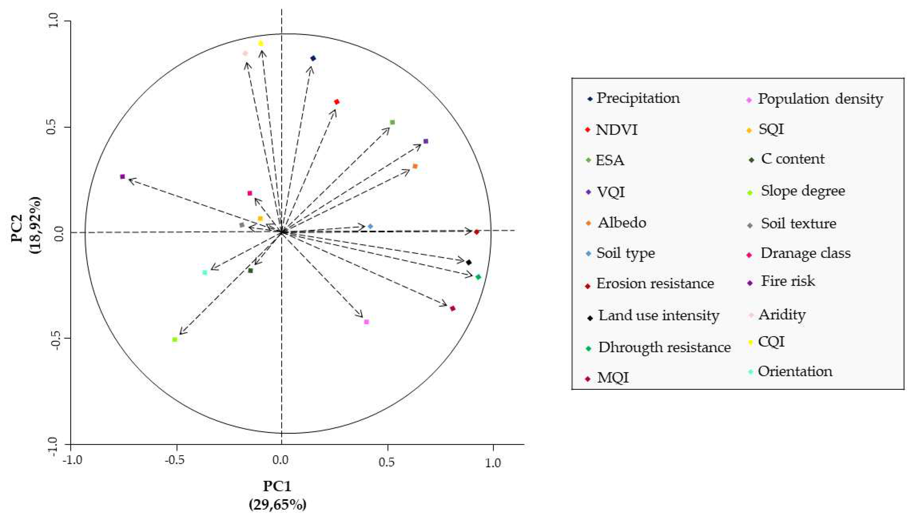
| Variables | PC1 | PC2 | PC3 |
| Precipitation | 0.12 | 0.86* | 0.04 |
| Aridity | -0.15 | 0.89* | 0.00 |
| Guidance | -0.37 | -0.17 | 0.14 |
| Fire risk | -0.82* | 0.34 | -0.16 |
| drought resistance | 0.91* | -0.17 | 0.14 |
| NDVI | 0.33 | 0.70 | 0.04 |
| Erosion resistance | 0.90* | 0.00 | 0.18 |
| Soil texture | -0.19 | 0.06 | 0.84* |
| Drainage class | -0.13 | 0.12 | 0.76* |
| Albedo | 0.61* | 0.35 | -0.17 |
| Soil type | 0.40 | 0.01 | -0.02 |
| Slope | -0.52 | -0.51 | -0.04 |
| OC content | -0.15 | -0.11 | 0.69* |
| LU intensity | 0.89* | -0.13 | 0.11 |
| Population density | 0.41 | -0.46 | -0.08 |
| CQI | -0.10 | 0.92* | 0.03 |
| VQI | 0.75* | 0.46 | 0.11 |
| SQI | -0.06 | 0.02 | 0.88* |
| MQI | 0.76* | -0.39 | 0.00 |
| ESA | 0.51 | 0.55 | 0.43 |
| Eigenvalues | 4.45 | 2.84 | 1.91 |
| Variance (%) | 29.65 | 18.92 | 12.75 |
| Accumulated variance (%) | 29.65 | 48.56 | 61.31 |
Disclaimer/Publisher’s Note: The statements, opinions and data contained in all publications are solely those of the individual author(s) and contributor(s) and not of MDPI and/or the editor(s). MDPI and/or the editor(s) disclaim responsibility for any injury to people or property resulting from any ideas, methods, instructions or products referred to in the content. |
© 2023 by the authors. Licensee MDPI, Basel, Switzerland. This article is an open access article distributed under the terms and conditions of the Creative Commons Attribution (CC BY) license (https://creativecommons.org/licenses/by/4.0/).


