
Submitted:
25 September 2023
Posted:
28 September 2023
You are already at the latest version
Abstract
The search for a continuous continental record of interglacial periods in semi-arid regions is problematic due to the absence of stable and continuous sedimentary systems over time in this type of climate. In this work, a relatively stable basin is described and analyzed during the last interglacial in a semi-arid region of the western Mediterranean. For this purpose a geomorphological, stratigraphic and sedimentological study has been carried out, with dating through 230Th. A semi-endorrheic Pleistocene basin has been identified, with two units that correspond to a fluvial-lacustrine system (unit P1) and an alluvial system (unit P2). Unit P1 has been dated in the MIS 5e interglacial episode. A framework is described in which the Aljezares Quaternary basin can be considered as a possible source of paleoenvironmental and paleoclimatic information in semi-arid regions from the last interglacial period in future studies.
Keywords:
Semiarid Climate
; Western Mediterranean
; MIS 5
; Geomorphology
; Sedimentology
1. Introduction
The available continental record of recent interglacial episodes is limited, with lake systems, especially in temperate or humid zones, being one of the main sources of terrestrial climate and environmental data [1]. This implies scarce paleoenvironmental and climatic data on dry regions due to their limited hydrology to form lakes or lacustrine deposits. However, coastal areas offer valuable insights into the last glacioeustatic climatic changes during the Pleistocene through the study of coastal terraces [2], although the erosive nature of the coastal environment limits its suitability for preserving continuous paleoenvironmental information.
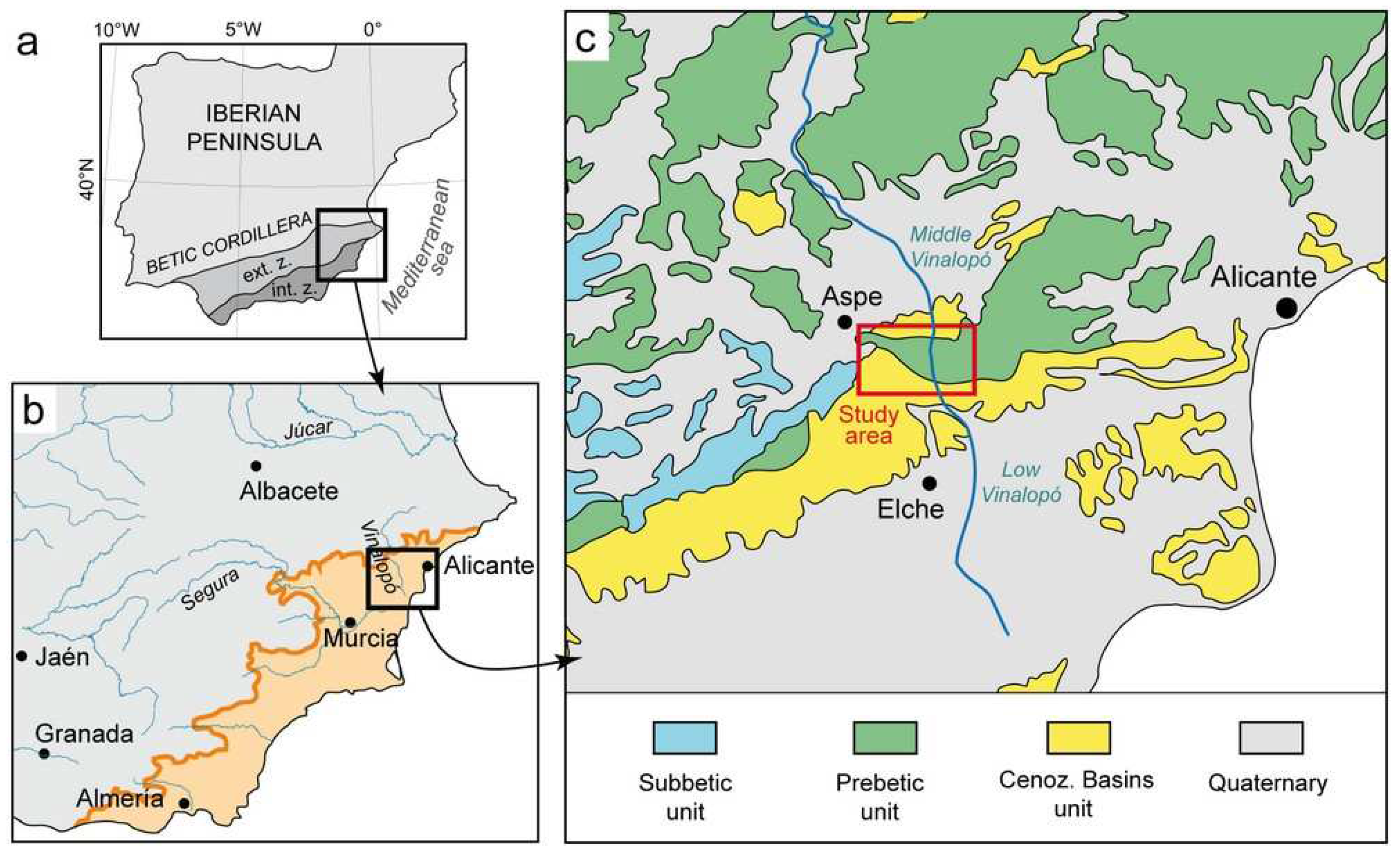
The southeast region of Spain is under semiarid Mediterranean climate within the drylands fringe of the Iberian Peninsula [3] (Figure 1a,b). In this region, Pleistocene deposits have been extensively studied primarily in the coastal environment between Alicante and Almería provinces (SE Spain) where marine terraces provide particularly well preserved evidence of the last two interglacial episodes [4,5]. Inland record, however, has received minor attention, mainly because its limited outcropping and the difficulties to its chronostratigraphic correlation. In this study, an example of inland record from the Vinalopó River basin (Alicante, SE Spain) is shown.
Plio-Pleistocene coastal lagoon and alluvial deposits comprised the distal part of the Vinalopó basin [6]. Upstream, the middle part of the basin is mostly constituted by Holocene deposits [7,8], whereas the Pleistocene record are limited to the piedmont of nearby reliefs [9]. However, smalls local basins located in the reliefs between the distal and the middle part of the Vinalopó basin exposed relict Pleistocene deposits thus allowing the study of the pre-Holocene inland record. This work focuses on the record of one of these intra-mountain basins, the Los Aljezares Nature Reserve, sited just between the middle and distal parts of the Vinalopó basin. There, well preserved Pleistocene deposits configured the inland fill of the basin and, additionally, give us valuable information about the activity of Neanderthal communities mainly in its path from continental to coastal areas [10]. This work aims to describe and provide a framework of the geomorphologic and sedimentary evolution of a Pleistocene inland record from southeast Iberia, an area of severe semiarid Mediterranean climate.
2. Geological setting
Los Aljezares basin is located near the town of Aspe (Alicante province, SE Spain) in an intra-mountain area within the External Zones of the Betic Cordillera. The study area comprises Pleistocene deposits within wide valleys eroded along the Betic Cordillera (Figure 2a,b), occupying the Prebetic and the Cenozoic Basins units [11]. This zone is crossed by the north-to-south entrenching of the Vinalopó River and it is the boundary between the middle and the low (distal) part of the Vinalopó River basin (Figure 1c).
Figure 1.
Location maps of the studied area. (a) Iberian Peninsula in the western Mediterranean and his relation with Betic Cordillera. (b) Boundary of drylands environments in southest of Iberian Peninsula with scarce precipitations more than 7 months/year (from Machado et al. [3]). (c) Geologic map of the western area of External Zones in Betic Cordillera where Vinalopó River is shown.
Prebetic unit is here mainly constituted by Triassic rocks composed by clays, sandstones, dolomites and gypsum attributed to the Upper Triassic Keuper Facies [12]. The deposits in the Cenozoic Basins mainly consist of marls, limestones and conglomerate alternations attributed to Middle to Upper Miocene (Serravallian-Tortonian stages) and arranged in a complex tectonic structure [9,12,13].
3. Methods
This study spans a geomorphological, stratigraphic and sedimentological approach, although other geological methodologies have been briefly used. For the stratigraphic description, the use of a stratigraphic panel has been chosen to get a complete representation of the horizontal and vertical scales in the description of the units. In the case of the sedimentological study, the description of discrete types of facies has been carried out applying the methodology of facies association analysis. Due to the abundance of gastropods in the rocks studied, an analysis of the malacofauna of the most significant species has been included in the sedimentological study to enrich the available information about the facies studied. In addition, a petrographic characterization of the carbonate rocks has been included to expand the paleoenvironmental information. 230Th dating of the continental carbonates has been carried out at the Isotope Laboratory of Xi’an Jiaotong University, using a Thermo Neptune multicollector inductively coupled plasma mass spectrometer (MC-ICP-MS) following the methodology described in [14] and the decay constants reported in [15].
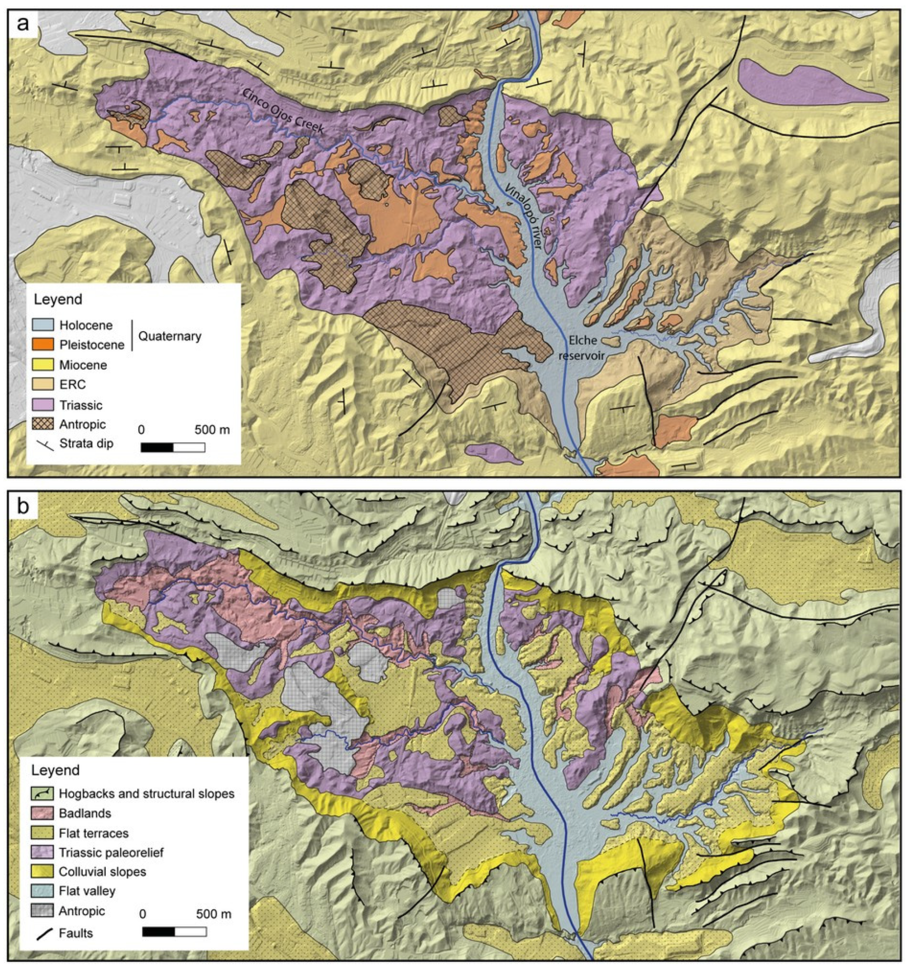
Figure 2.
Geology and geomorphology maps of Los Aljezares. (a) Geologic cartography of studied area (detailed position in Figure 1c). (b) Geomorphological zones recognized in the area.
Figure 2.
Geology and geomorphology maps of Los Aljezares. (a) Geologic cartography of studied area (detailed position in Figure 1c). (b) Geomorphological zones recognized in the area.
4. The Aljezares Quaternary basin
The study area is structured as an antiform with an open anticline core known as Clusé [16]. The flanks of the anticline are formed by Miocene rocks, whereas Triassic sequences are found in the core. In the latter, there is a difficult-to-assign unit called the Elche Reservoir Complex (ERC), remobilized during the Neogene but closely related to the configuration of the Triassic unit. The core, being more eroded compared to the flanks, creates a local inland basin with annular shape where the Quaternary deposits are preserved (Figure 2a).
Two chronostratigraphic units can be distinguished within the Quaternary deposits; a Holocene unit associated to the Vinalopó River and Elche reservoir located to the South and; a Pleistocene unit that outcrops in form of discontinuous terraces covering the paleo-relief left above after the erosion of the Triassic and ERC units (Figure 3a). The most relevant evidence of such pre-Holocene deposits is found in the core of the antiform fold, despite small outcrops are also identified beyond the study area.
Additionally, a Middle Paleolithic archaeological site has been described in the Pleistocene unit, identifying two levels of Neanderthal occupation [10]. This site is attributed to the Middle Paleolithic (Pleistocene s.l.) based on the type of industry collected (Levallois technology) and interpreted as an open-air temporary site in gravel areas where flint pebbles were abundant.
5. Geomorphology
Geomorphological features in the study area are mainly linked to the differences in lithology between the chronostratigraphic units: Triassic, Miocene, Pleistocene and Holocene. In this line, six geomorphological zones have been distinguished as follows (Figure 2b and Figure 4a):
- Successive hogbacks and structural slopes. This zone shows a process of strong differential erosion between alternating weak and resistant Miocene bedrock. Mainly linked to the lithology and the anticline structure, they constituted the ring-shaped hills found as boundary of the Quaternary basin. This structure is cut by the Vinalopó River in North to South direction;
- Badlands. This zone is linked to the drainage system of the Vinalopó River within the core of the anticline and it is developed above the less resistant rocks of the Triassic, ERC and Pleistocene units. Its development is mainly associated to the tributary channels existent in the western area of the basin (Cinco Ojos Creek).
- Flat terraces. This zone is constituted by isolated flat areas found at the top of the Pleistocene deposits and located 18–20 meters above the talweg of the Vinalopó River (170 and 205 meters above sea level). They occupy tens to hundreds of meters of lateral extension in the center of the basin extending through the boundaries (Figure 2b). Their configuration is linked to the incision of the Holocene drainage network into the Pleistocene infill, characterized by flat tops and vertical scarps (Figure 3a,b).
- Triassic paleorelief. It is composed by topographic heights within the anticlinal core that have not been occupied by Quaternary sedimentation, mainly corresponding to the dolomitic or the most massive gypsum and clay units from the Triassic formations (Figure 4a). They show very complex structures with a chaotic appearance in form of topographic highs scattered throughout the area above the flat terraces.
- Colluvial slopes. Conformed by discontinuous patched areas with gentle slopes and logarithmic expression that link the high Miocene reliefs with the flat Pleistocene terraces (Figure 4b). They can be described as pediment-type depositional/erosive systems from the upper areas of the Neogene ridge reliefs toward the center of the Quaternary basin.
- Flat valley. This zone is occupied by the Vinalopó River, Elche reservoir and Holocene sedimentation.
Geomorphological zones in Aljezares basin are commonly affected by recent human activity. The major anthropic alterations are observed in the old gypsum and clay quarries located in the Triassic deposits and the recent railroad of the high-speed train line that crosses the Aljezares basin from North to South. Additionally, agriculture fields are located along the whole basin in flat terraces, taking advantage of the flat or gentle slopes. The above-mentioned factors complicate a detailed geomorphological characterization due to an eventually erasing of some geomorphological features.
6. Stratigraphy and sedimentology of the Pleistocene deposits
Pleistocene deposits crop out above the angular unconformity that affects the Triassic and ERC units. The unconformity constitutes a sharp paleo-relief, with deeper areas located close to the present-day drainage network (Vinalopó River, Elche reservoir and Cinco Ojos Creek). Therein, Pleistocene horizontal strata reach up to 16 m of thickness and onlap the irregular unconformity (Figure 5a). Through the boundaries of the basin, low-angle-dipping strata gradually lose thickness and pinch out (Figure 5b). The central part of the basin is eroded by the present course of the Vinalopó River, leaving visible and accessible outcrops where the deposits have been described and the stratigraphic panel has been made (Figure 6). Within the Pleistocene deposits, two units can be distinguished (P1 and P2) limited by a minor unconformity described as a paraconformity linked to paleosol development (Figure 5c). Conversely, it shows an erosive disconformity in the central zone (Figure 5d).
Attending to the sedimentology, two facies associations can be distinguished (Table 1), representing a system of colluvium and alluvial fans with centripetal sediment supply, and a fluvio-lacustrine system.
Colluvium and alluvial fans (Table 1) are mainly constituted of matrix-supported conglomeratic facies with scattered blocks, fine to coarse sandstones moderately sorted and intercalations of thinner tabular and channelized bodies of clast-supported conglomerates with moderate sorting (Figure 8a). Pulmonate gastropods such as Iberus alonensis and Sphincterochila candidissima are very common (Figure 7a). Gastropods mainly appear dispersed within the conglomeratic facies and show very good preservation without signs of reworking that suggests they inhabited in the deposits after sedimentation (Figure 8b). Matrix-supported conglomerates are interpreted as the result of debris flows deposited in colluvium systems and in proximal parts of alluvial fans. Through the middle to distal parts of the alluvial fans sandy facies and clast-supported conglomerates become more abundant and would reflect sandy flats and ephemeral channelized and non-channelized currents. Regarding gastropod fauna, both species are present today in the area and represents a common association in semi-arid environment, being S. candidissima xerophilic, inhabiting arid sun-exposed terrains with thin and dry soils [17] and I. alonensis associated with calcicolous soils related with Mediterranean steppe environments near rivers or farmlands [18].
The Fluvio-lacustrine system (see Table 1) consists of a wide variety of facies. The coarsest facies are conglomerates with a well-to-moderate sorting, lenticular shape, erosive base, lateral continuity of tens of meters, and a variable thickness (Figure 8c). Extra-basinal pebbles derived from the surrounding Miocene rocks are primarily found here. These conglomeratic bodies alternate with bluish and yellowish sandy and muddy facies where root traces, rhizoliths and well preserved gastropods of the species Theodoxus fluviatilis and the genus Melanopsis sp. are observed (Figure 7a). Furthermore, these gastropods can form high-concentration shell accumulations (known as lumaquela). Within this facies association, carbonate levels with boundstone facies [19] are observed (Figure 8d). Boundstone consists of domical and tubular tufa with stromaltolite-type concentric laminations (Figure 7b). These levels have variable thickness from few centimeters to one meter and good lateral continuity up to 50 meters (Figure 6). This facies association is interpreted as the product of high-energy channels with relatively stable water flow and stagnant water bodies or permanent ponds, which would also include marshy areas protected from the currents. Supporting this interpretation, Melanopsis sp. and T. fluviatilis are aquatic gastropods with the latter being indicator of hard-water fluvial and lacustrine environments [20]. Attending to the facies classification for freshwater carbonates proposed by Arenas-Abad et al. [21], most of the boundstone facies correspond to coated streams growing upwards produced by microbial communities, although the interaction of bryophytes cannot be ruled out (Figure 7b). This type of tufas is common in aquatic environments, where a more or less stable water body allows their development (e.g., [22]).
7. Chronostratigraphy
The first absolute dating of sequences from the study area was carried out by Eixea et al. [10] on the continental carbonate levels of the P1 unit with a sample of 20 gr analyzed by alpha spectrometry that offered an age of 132,284 + 10,873 /- 10,022 yr. This result led these authors to attribute to the uppermost part of the Middle Pleistocene to Late Pleistocene close to MIS 6/5 boundary.
In this work, new datings have been carried out on these same carbonates using a more precise MC-ICP-MS technology giving as a result dates of 129,406 ± 2,729 yr and 125,115 ± 2,484 yr for the P1 unit, which places the chronology more precisely in the Marine Isotope Stage (MIS) 5e, at the beginning of the last interglacial maximum (Table 2).
Attempts were made to date unit P2, but no optimal materials or deposits were found for reliable dating.
8. Discussion
Considering first the geomorphological analysis, both colluvial slopes and flat terraces zones are part of a single ancient geomorphological unit or Pleistocene geomorphological surface. This observation is compatible with a pediment shape that constituted the top level of the Pleistocene basin sedimentary filling. This fill had centripetal dynamics with unconfined drainage systems from the Miocene structural ridges and colluvial slopes that surround the basin, covering most of the core of the anticline except in some high Triassic paleoreliefs. Subsequently, this geomorphological surface had to be dismantled in the development of the badlands systems and recent flat valleys that are controlled with recent fluvial/alluvial dynamics. This Holocene dismantling of the Pleistocene geomorphological surface has been only partial, leaving remains of the terrace systems that can be observed today.
8.1. Evolution of the Pleistocene sedimentary basin
Several stages can be established in the evolution of the Quaternary forms and deposits of the Los Aljezares basin (Figure 9):
The first event that can be recognized in relation to Quaternary processes is the formation of paleo-reliefs on the Triassic and ERC rocks. Afterwards, sedimentation processes occurs during MIS 5e shaping an unconformity above the paleo-relief, therefore any erosive event of the basement sequence must be triggered earlier than the sedimentation. A tentative assignment of this erosive event may point to MIS 6, since it constituted an important global drop in base sea level [23] that would be able to control the processes of channel entrenchment that shaped the Aljezares Pleistocene basin.
Subsequently, Los Aljezares basin was filled in two different stages represented by the two Pleistocene units. Unit P1 is dated to MIS 5e, and corresponds to a fluvio-lacustrine environment system as indicated by the sedimentological analysis. The extrabasinal nature of the conglomerate components and the relative stability of the channels suggest a north-to-south feeding in an open basin.
Regarding P2 unit, it starts with an unconformity on the previous unit. This represents a paraconformity with depositional hiatus, although locally it has erosive features as indicated by the central location of the disconformity and angular unconformity. Unit P2 ends with a pediment-like geomorphological surface related to the colluvial slopes and the Pleistocene flat terraces described in the geomorphological analysis. This top level of filling is compatible with the highstand that characterizes the last interglacial [23], so P2 unit is likely to be related to small eustatic oscillations or tectonic processes, but within MIS 5. Therefore, the P2 unit could represent a minor rupture during the Pleistocene filling with a brief break in sedimentation with a local entrenchment in a west-east direction, thus dismantled the Triassic materials located in the west part of the Aljezares basin.
During the lowstand isotopic stages (MIS 4-2), the dismantling of the Pleistocene interglacial deposits occurs due to entrenchment associated with the falls of base level during the last glacial cycle. This moment may be the starting point of the development of the current Vinalopó fluvial network and the badlands.
Finally, during the Holocene a north-to-south axial filling occurs in favor of the previous entrenchment with the development of the deposits of the current fluvial network of the Vinalopó River.
8.2. Paleoenviromental reconstruction
The first stage of filling is represented by the P1 unit mainly constituted by the fluvio-lacustrine facies association. Moderately-well sorted conglomerates have been interpreted as deposited by high-energy channels under fluvial dynamics with north-south direction. In the same unit, muddy and sandy facies with presence of the aquatic gastropods Theodoxus fluviatilis and Melanopsis sp., stromatolite-like tufa, and locally root traces and rhizoliths are interpreted as deposited in areas with lower flow velocities. Stagnant water bodies and marshy areas would be occasionally crossed by the high energy channels characterizing a fluvio-lacustrine system with semi-endorheic behavior. Thereby, the drainage would had been axially connected to the marine base level in high energy events, while in stages of moderate rains it would had maintained an endorheic drainage relatively disconnected from the base level but stable, since no other unconformities are observed within P1 (i.e., mudcrack levels, well-developed paleosols).
High-energy channels fed by north-south currents from outside of the Quaternary basin, introduced extrabasinal cobbles, including flint cobbles. The work of Eixea et al. [10] describes the archaeological site linked to the use by Neanderthal communities of these flints, where the conglomerates are interpreted as episodic channels related to specific high-energy events. In the same unit, facies compatible with a closed (lacustrine) system have been described, such as sandstones with rhizolites, lutites and levels of stromatolite-type tufa. Same authors [10] interpreted this set as stable underwater conditions, where aquatic gastropod fauna has also been found.
Due to the highstand context of the last interglacial maximum, the high-energy events would not have an erosive behavior, however, producing episodes of sedimentation that are reflected in the well-developed conglomerate levels where the activity of the Neanderthal communities took place. This intermittent high-low energy dynamic is compatible with a decadal cadence of torrential episodes similar to that currently observed in southeastern Spain [3]. To compare the cadence and magnitude of these decadal events with respect to the current climatic dynamics in this region, detailed paleoclimatic studies are needed in the sedimentary records of lacustrine facies and in continental carbonates to explore such potential links and mechanisms.
Regarding unit P2, the sedimentological analysis indicates a facies association of colluvium and alluvial fans, with predominant conglomeratic and sandy facies and subordinate muddy sediments. This association has been interpreted as gravity flows, ephemeral channels and sheet flows related to poor developed channelized bodies in a non-hierarchical network. These can be interpreted as colluvium and the proximal to medial parts of alluvial fans deposited by intermittent ephemeral channels. Non-resedimented pulmonate gastropods Iberus alonensis and Sphincterochila candidissima have been found in this facies association, and their terrestrial and xerophilic ecological context with thin and dry soils is compatible with the interpretation offered for this facies association. The identified facies can also be related to intermittent non-seasonal decadal dynamics. Due to the limited accommodation space available of the basin, a stable relative base level that would favor a continuous sedimentary or paleontological record was not developed, since it was close to being completely filled.
9. Conclusions
This paper describes the evolution of a Pleistocene basin in the semi-arid region of the southeast of the Iberian Peninsula. It corresponds to the beginning of the last interglacial period in MIS 5e. The basin is associated with an antiform structure where the core is formed mainly by Triassic rocks and the ERC unit associated with the Triassic structure, while the flanks are Neogene carbonate rocks. Within this annular configuration are found the Quaternary series formed by the Holocene deposits of the current fluvial dynamics of the Vinalopó River, and the Pleistocene deposits where lithic industry associated with the Middle Paleolithic has been found.
The geomorphological analysis shows a close relationship between the geomorphological configurations and the lithologies. Furthermore, it shows how the Pleistocene flat terraces and colluvial slopes are parts of a single geomorphological surface that represents the final filling of the Pleistocene basin. Therefore, the morphologies of badlands and present flat valleys must be the result of a subsequent entrenchment.
The stratigraphy of the Pleistocene fill shows two Pleistocene units P1 and P2, separated by a stratigraphic unconformity.
The sedimentological study has revealed two facies associations in the Pleistocene deposits. Unit P1 is mainly characterized by fluvial-lacustrine facies association. Therein, high-energy fluvial channels with north-to-south feeding and environments with relatively stable water table have been interpreted, under a semi-endorheic dynamic. In this unit, stromatolite-like tufa structures have been dated by 230Th method providing ages of 129,406 ± 2,729 yr and 125,115 ± 2,484 yr, placing unit P1 in MIS 5e. The P2 unit mainly comprises colluvial and alluvial fans facies. Sedimentary systems in this unit would be fed from the western part of the basin. This unit represents the final filling of the Pleistocene basin of Los Aljezares.
In the evolution of the Pleistocene basin, several stages are recognized: i) formation of a paleorrelief on the Triassic and the ERC during the MIS 6 lowstand; ii) sedimentation of a fluvial-lacustrine system at the beginning of MIS 5 with a preferential north to south feeding and where the activity of Neanderthal communities has been recorded; iii) a brief process of entrenchment in the MIS 5 due to eustatic oscillations or tectonic processes that left to the final fill of the basin by colluvial and alluvial fan systems bounded at the top by a pediment; iv) dismantling of the Pleistocene fill during the lowstand of the MIS 4-2 glaciation cycle and configuration of the recent drainage system; and v) sedimentation of Vinalopó River during the Holocene with a new north-south system.
The paleoenvironmental history of the Los Aljezares Pleistocene starts at the beginning of MIS 5 with the P1 unit under semi-endorheic dynamics controlled by a high base level. In this context, periods of low energy occur, represented by lacustrine facies and fauna, which are eventually interrupted by high- energy channels. This filling dynamic is compatible with a decadal cadence of high-energy episodes characteristic of semi-arid climates. After a brief destabilization (whose origin still cannot be resolved), the filling of the Pleistocene basin continues with the P2 unit until its total infill with colluvium and alluvial fans facies due to the progressive elimination of accommodation space of the basin during the highstand of the MIS 5. Assuming the differences in the position of the base level, there is a similarity between the climate dynamics of MIS 5 and the current climate under the decadal high-energy episodes of semi-arid climates. To establish a reliable comparison between the climates of the last interglacial and the present interglacial, further detailed studies will be needed on the records observed and described in this work from the Los Aljezares basin.
Author Contributions
Conceptualization, J.C.-G. and D.D.-C.; methodology, J.C.-G., C.P.-M. and H.G.; writing—original draft preparation, J.C-G; writing—review and editing, J.C-G, D.D.-C., J.E., J.C.C. and C.P.-M.; supervision, J.C.C. All authors have read and agreed to the published version of the manuscript.
Funding
The research has been funded through the following Spanish research projects: I+D+i PID2021-122308NA-I00 (NESUBSTRA-UV) and I+D+i PID2021-123510OB-I00 (QTECTIBERIA-USAL) by the MICIN.
Acknowledgments
The geological fieldworks are part of Asociación Cinco Ojos Observatorio de Patrimonio activities in collaboration with Aspe Council.
Conflicts of Interest
On behalf of all authors, the corresponding author states that there are no conflicts of interest.
References
- Bagniewski, W.; Rousseau, D.D.; Ghil, M. The PaleoJump database for abrupt transitions in past climates. Nature Sci. Rep. 2023, 13, 4472. [Google Scholar] [CrossRef] [PubMed]
- Rovere, A.; Raymo, M.E.; Vacchi, M.; Lorscheid, T.; Stocchi, P.; Gómez-Pujol, L.; Harris, D.L.; Casella, E.; O’Leary, M.J.; Hearty, P.J. The analysis of Last Interglacial (MIS 5e) relative sea-level indicators: Reconstructing sea-level in a warmer world. E.-Sci. Rev. 2016, 159, 404–427. [Google Scholar] [CrossRef]
- Machado, M.J.; Benito, G.; Barriendos, M.; Rodrigo, F.S. 500 Years of rainfall variability and extreme hydrological events in southeastern Spain drylands. J. Arid Env. 2011, 75, 1244–1253. [Google Scholar] [CrossRef]
- Goy, J.L.; Hillaire-Marcel, C.; Zazo, C.; Ghaleb, B.; Dabrio, C.J.; González, A.; Bardají, T.; Civis, J.; Preda, M.; Yébenes, A.; et al. Further evidence for a relatively high sea level during the penultimate interglacial: open-system U-series ages from La Marina (Alicante, East Spain). Geod. Acta 2006, 19, 409–426. [Google Scholar] [CrossRef]
- Zazo, C.; Goy, J.L.; Dabrio, C.J.; Bardají, T.; Hillaire-Marcel, C.; Ghaleb, B.; González-Delgado, J.A.; Soler, V. Pleistocene raised marine terraces of the Spanish Mediterranean and Atlantic coasts: records of coastal uplift, sea-level highstands and climate changes. Mar. Geol. 2003, 194, 103–133. [Google Scholar] [CrossRef]
- Goy, J.L.; Zazo, C. The role of neotectonics in the morphologic distribution of the Quaternary marine and continental deposits of the Elche Basin, southeast Spain. Tectonoph. 1989, 163, 219–225. [Google Scholar] [CrossRef]
- Ferrer García, C. Dinámica fluvial durante el inicio del Holoceno superior en el curso medio del Vinalopó (Alicante, España). Bol. Geol. Min. 2018, 129, 305–330. [Google Scholar] [CrossRef]
- Cuenca, A.; Walker, M.J. Terrazas fluviales en la zona bética de la Comunidad Valenciana. In El Cuaternario del País Valenciano; Roselló, V.M., Ed.; Universidad de Valencia: Valencia, Spain, 1995; pp. 105–114. [Google Scholar]
- Leret, G.; Nuñez, A.; Colodrón, I. 1976. Mapa Geológico de España, 1:50.000 hoja n° 871 (Elda) y memoria, 2nd ed.; IGME: Madrid, Spain, 1976; p. 65. [Google Scholar]
- Eixea, A.; Cuevas-González, J.; Díez-Canseco, D.; Bel, M.A.; Bonnet, A.; Carrión, Y.; Martínez-Alfaro, A.; Martínez-Rubio, V.; Martínez-Varea, C.M.; Pardo, R.; et al. Los Aljezares archaeological site (Alicante, Spain) and the MIS 6/5 open-air settlement in the Iberian Peninsula. J. Quat. Sci. 2022, 1–21. [Google Scholar] [CrossRef]
- Vilas, L.; Castro, J.M.; Martín-Chivelet, J. El Prebético del Sector Oriental. In Geología de España; Vera, J.A., Ed.; SGE-IGME: Madrid, Spain, 2004; pp. 361–363. [Google Scholar]
- Tent-Manclús, J.E. Estructura y estratigrafía de las Sierras de Crevillente, Abanilla y Algayat: su relación con la falla de Crevillente. PhD dissertation, Universidad de Alicante, Alicante, 2003. [Google Scholar]
- Pignatelli, R. Mapa Geológico de España, 1:50.000 hoja n° 893 (Elche) y memoria, 2nd ed.; IGME: Madrid, Spain, 1972; p. 65. [Google Scholar]
- Cheng, H.; Edwards, L.R.; Hoff, J.; Gallup, C.D.; Richards, D.A.; Asmerom, Y. The half-lives of uranium-234 and thorium-230. Chem. Geol. 2000, 169, 17–33. [Google Scholar] [CrossRef]
- Cheng, H.; Edwards, L.R.; Shen, C.-C.; Polyak, V.J.; Asmerom, Y.; Woodhead, J.; Hellstrom, J.; Wan, Y.; Kong, X.; Spötl, C.; et al. Improvements in 230Th dating, 230Th and 234U half-life values, and U–Th isotopic measurements by multi-collector inductively coupled plasma mass spectrometry. E. Pl. Sci. Lett. 2013, 371–372, 82–91. [Google Scholar] [CrossRef]
- Archambault, M.; Lhénaff, R.; Vanney, J.R. Documents et méthode pour le commentaire de cartes: Fascicule 2: Les reliefs structuraux; Masson: Paris, France, 1970; p. 166. [Google Scholar]
- Gasull, L. Las Helicella (Xeroplexa) de Baleares. Gasteropoda pulmonata. Bol. Soc. Hist. Nat. Bal. 1964, X, 3–88. [Google Scholar]
- Martínez-Ortí, A. ; Robles,F. Moluscos Continentales de la Comunidad Valenciana; Conselleria de Territori i habitatge Comunitat Valenciana: Valencia, Spain, 2003; p. 197. [Google Scholar]
- Dunham, R.J. Classification of Carbonate Rocks According to Depositional Texture. In Classification of Carbonate Rocks; Ham, W.E., Ed.; AAPG: Tulsa, Oklahoma, 1962; pp. 108–121. [Google Scholar]
- Macan, T.T.; Maudsley, R. Fauna of the stony substratum in lakes in the English Lake District. Int. Verein. theor. angew. Limn.: Verhan. 1969, 17, 173–180. [Google Scholar] [CrossRef]
- Arenas-Abad, C.; Vázquez-Urbez, M.; Pardo-Tirapu, G.; Sancho-Marcén, C. Fluvial and associated carbonate deposits. In Carbonates in Continental Settings: Facies, Environments, and Processes; Alonso-Zarza, A.M., Tanner, L.H., Eds.; Elsevier: Amsterdam, Netherlands, 2010; Volume 61, pp. 133–175. [Google Scholar]
- Arenas, C.; Gutiérrez, F.; Osácar, C.; Sancho, C. Sedimentology and geochemistry of fluvio-lacustrine tufa deposits controlled by evaporite solution subsidence in the central Ebro Depression, NE Spain. Sediment. 2000, 47, 883–909. [Google Scholar] [CrossRef]
- Grant, K.M.; Rohling, E.J.; Ramsey, C.; Cheng, H.; Edwards, R.L.; Florindo, F.; Heslop, D.; Marra, F.; Roberts, A.P.; Tamisiea, M.E.; et al. Sea-level variability over five glacial cycles. Nature Comm. 2014, 5, 5076. [Google Scholar] [CrossRef] [PubMed]
Figure 3.
(a) Pleistocene deposits in Los Aljezares occupying the central part of the quaternary basin in form of sedimentary rocks with vertical scarps and horizontal stratification. In the foreground, riparian vegetation grows on Holocene deposits. In the background the Triassic paleorelief is observed. (b) Detail of the flat tops of Pleistocene deposits.
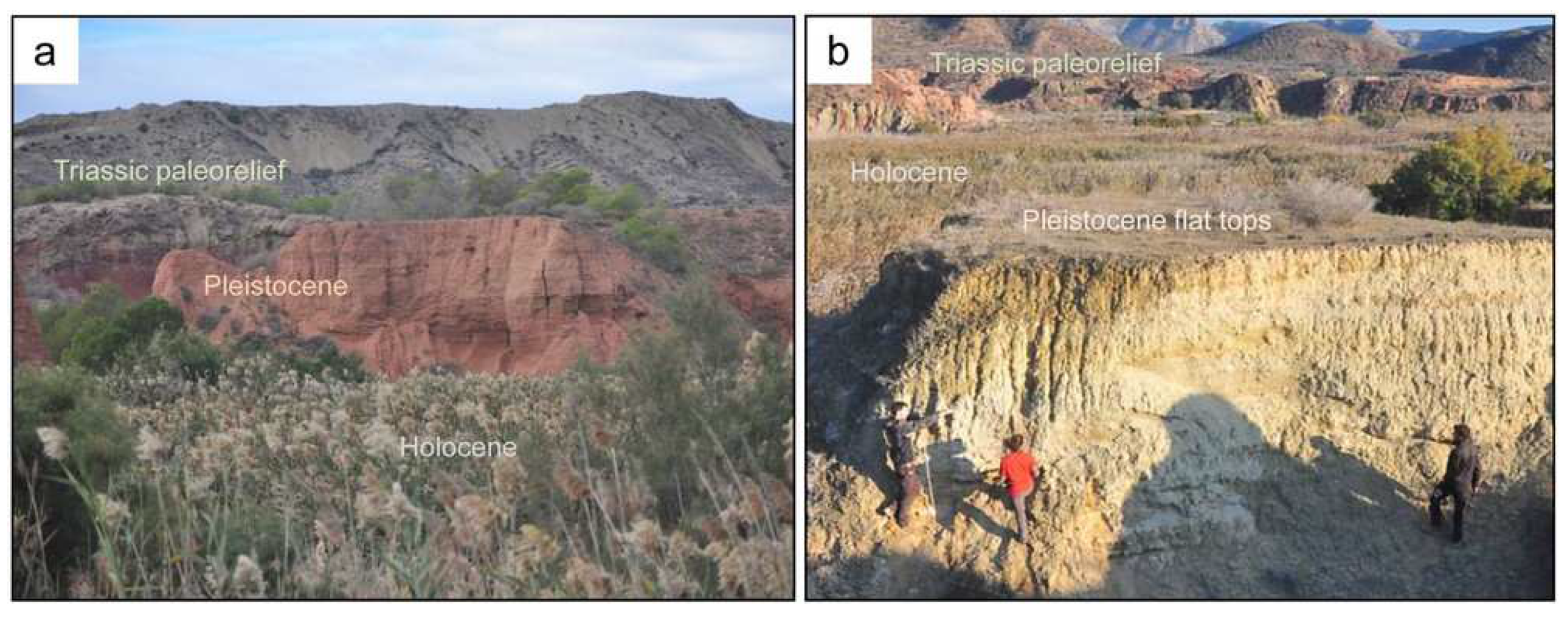
Figure 4.
(a) Panoramic view of main geomorphological zones. The Triassic paleorelief (Tr) appears dispersed between the Pleistocene flat terraces (Plst). The white striped line shows the limit of the Aljezares Quaternary basin with de foreground Betic reliefs, which marks the watershed of the Quaternary basin formed by the Miocene units (Mio). Notice the high anthropic interventions over Triassic formation, with exploitation of resources like clays and dolomite ballast. In addition, the trace of the high-speed train line is observed in the center of the image. (b) Colluvial slopes connecting de Miocene highs with Pleistocene deposits in the center of the basin.
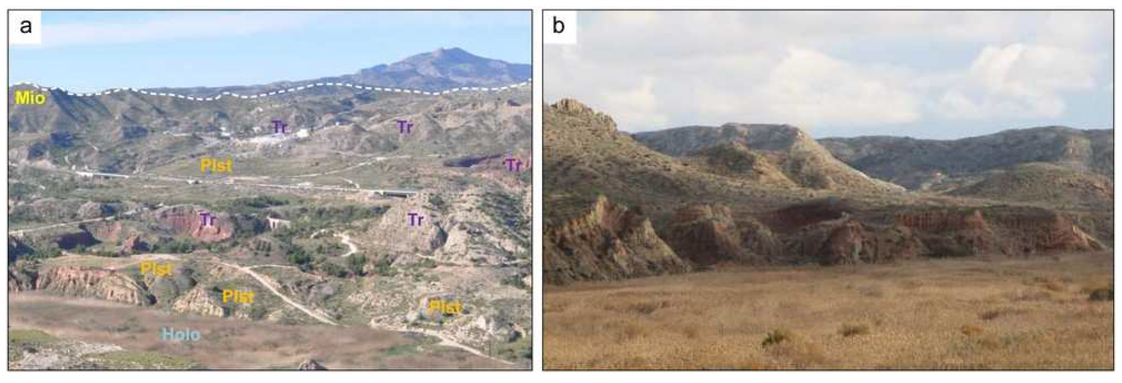
Figure 5.
(a) Pleistocene deposits in erosive irregular unconformity over the Triassic. The expansive onlap filling is shown. (b) Pleistocene deposits near the boundary of the basin. The feet of the person is over Triassic rocks, therefore the thickness, marked by the flat terrace, is not greater than three meters. Compare this image with its shown in Figure 3a. (c) Paraconformity (yellow line) with paleosol development (white line), where detail of root traces are shown. (d) Disconformity near the center of the basin with lag levels.
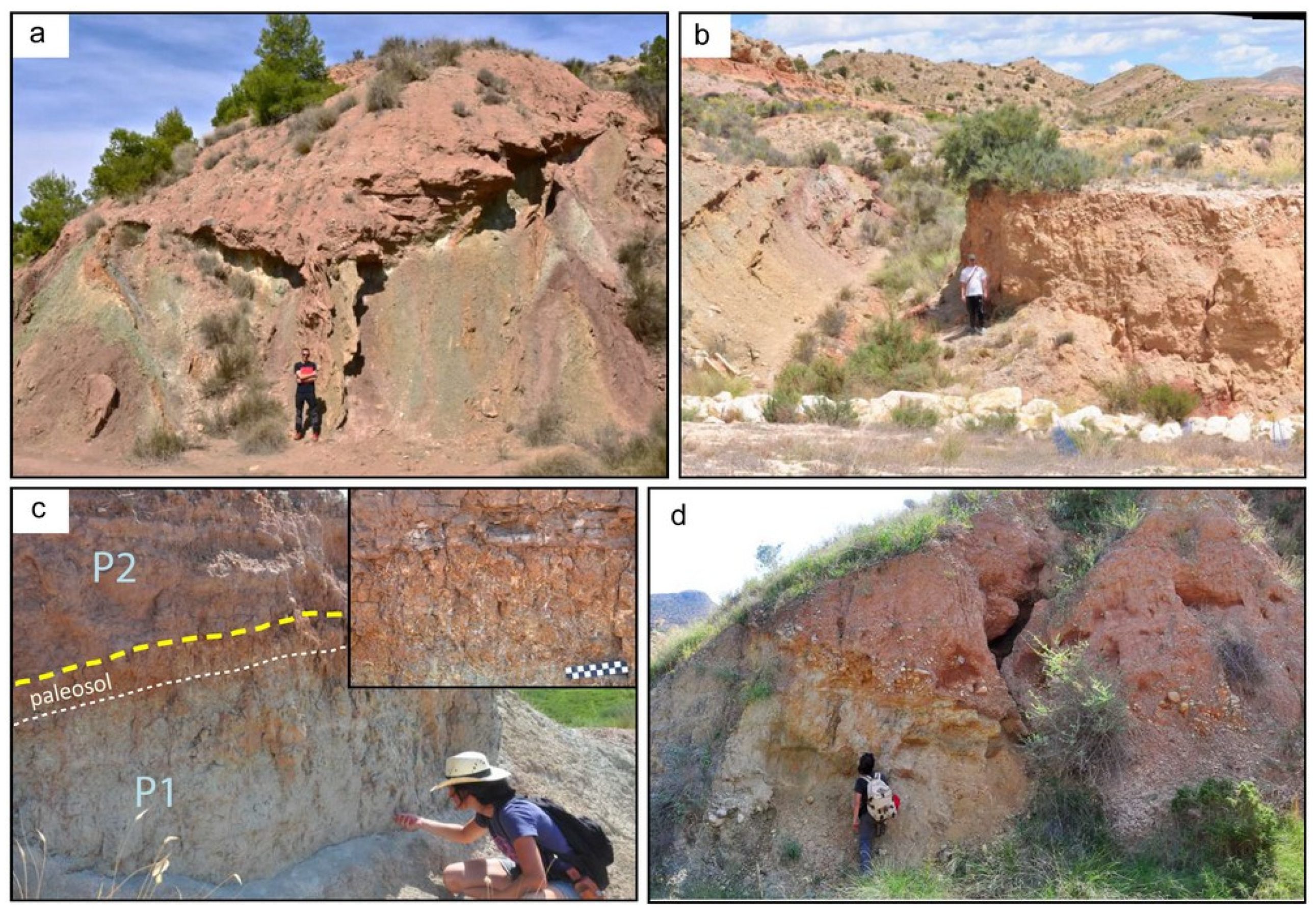
Figure 6.
Stratigraphic panel of P1 and P2 units showing the unconformity lateral variation between them. The position and value of dated carbonates are shown.
Figure 6.
Stratigraphic panel of P1 and P2 units showing the unconformity lateral variation between them. The position and value of dated carbonates are shown.
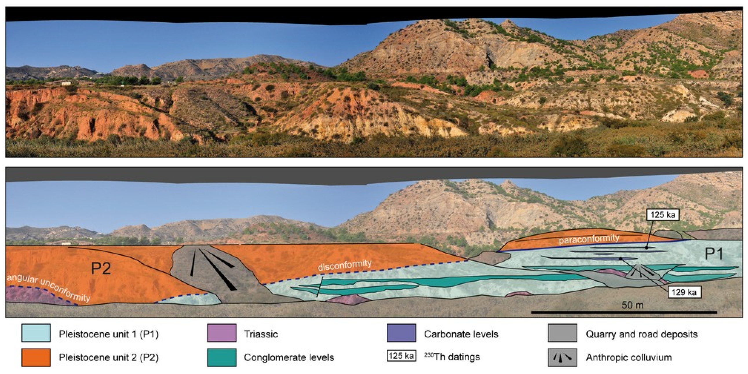
Figure 7.
(a) Gastropods observed in the Pleistocene deposits of Aljezares Quaternary basin. Scale is 2 cm. (b) Stromatolitic type lamination in domical tufa sample. The steams produced by microbial communities can be observed.
Figure 7.
(a) Gastropods observed in the Pleistocene deposits of Aljezares Quaternary basin. Scale is 2 cm. (b) Stromatolitic type lamination in domical tufa sample. The steams produced by microbial communities can be observed.
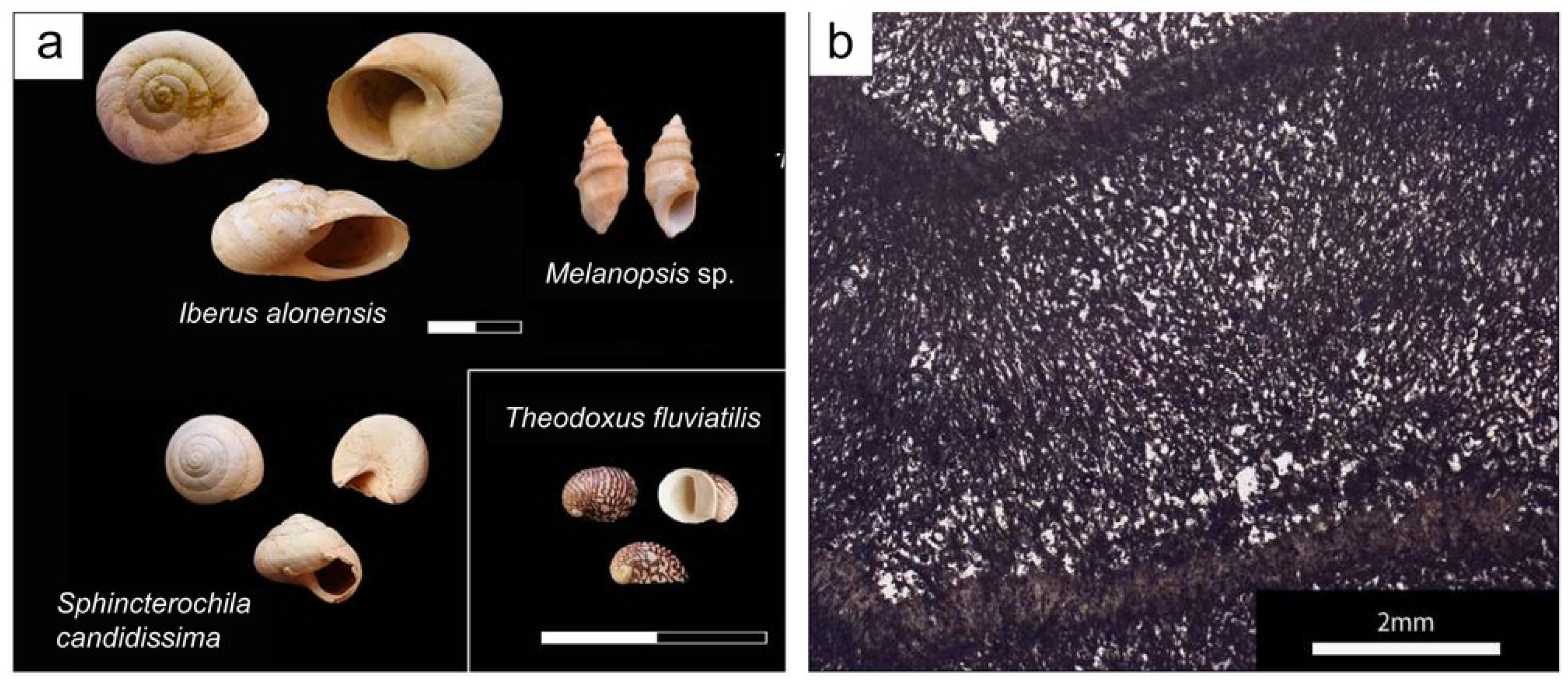
Figure 8.
(a) Colluvium and alluvial fans facies association in P2 unit with thin channelized bodies showing an erosive angular unconformity over Triassic rocks. (b) Detail of the pulmonate gastropod Iberus alonensis with good preservation in the colluvium and alluvial fans facies association (P2). (c) Fluvio-lacustrine facies association in P1 unit with conglomerates (C) alternated with sandy/muddy facies (S/M). (d) Carbonate level of tubular tufa in sandy/muddy deposits of the fluvio-lacustrine facies association (P1).
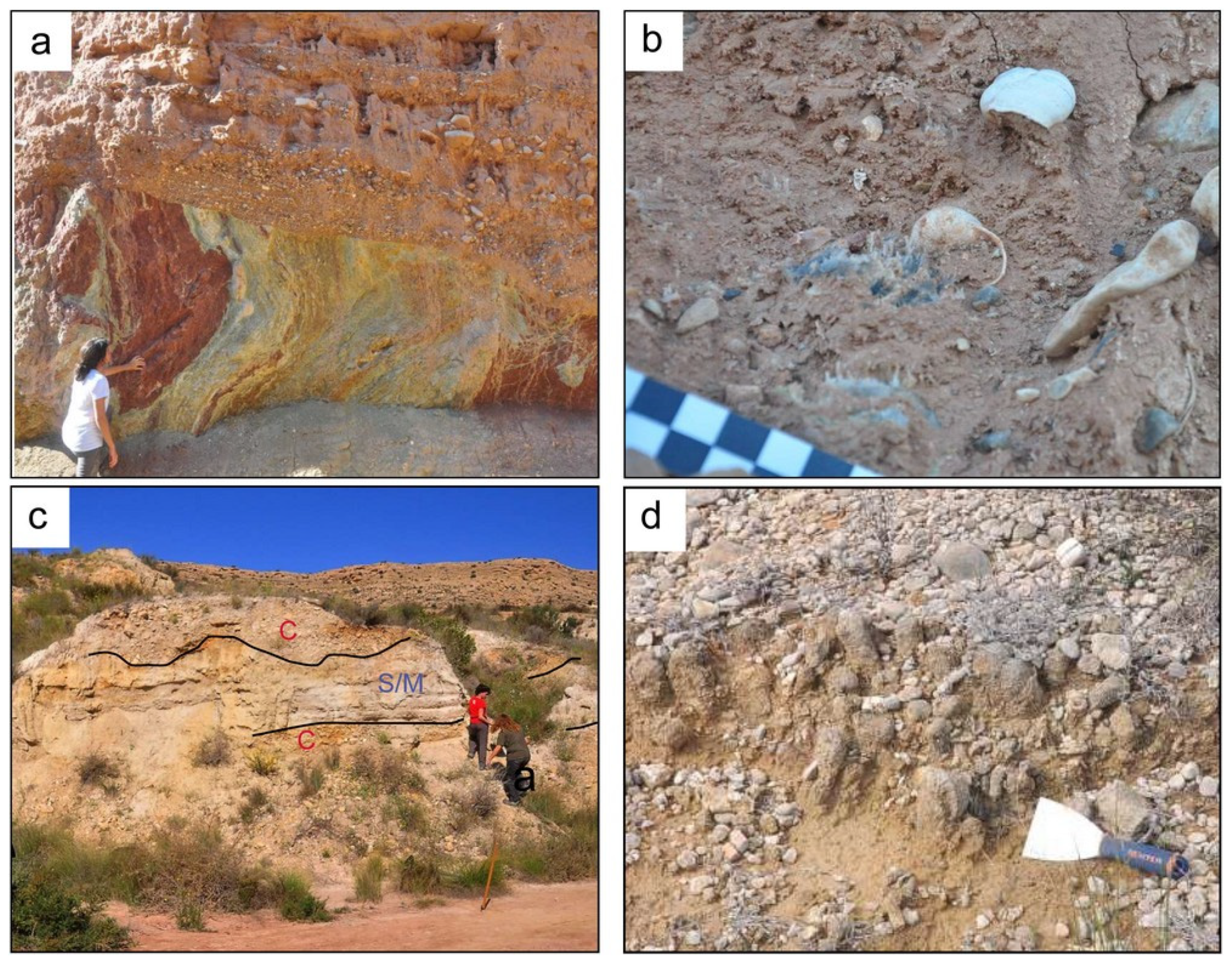
Figure 9.
Stages established in the evolution of the Aljezares Quaternary basin.
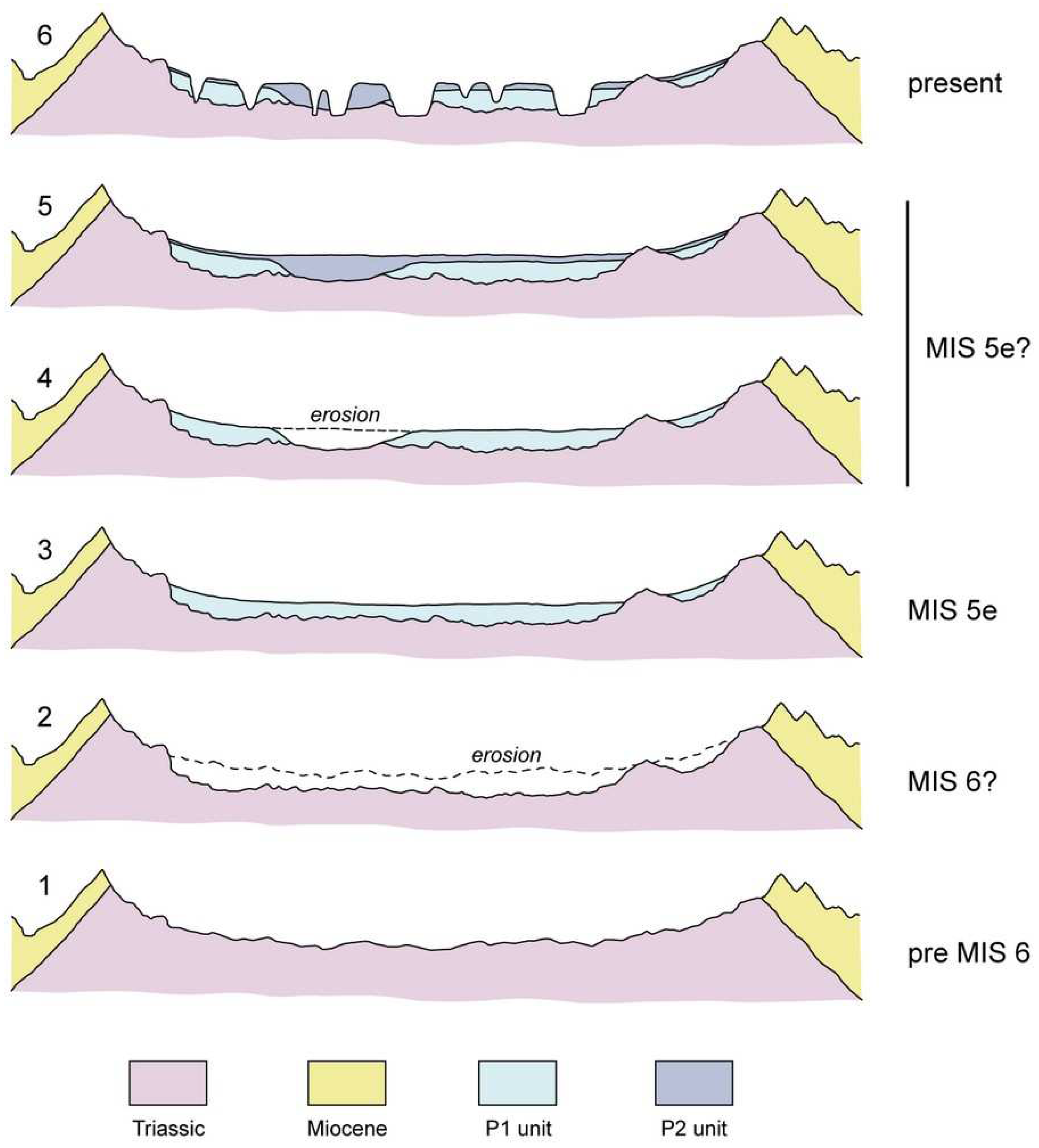

Table 1.
Facies associations recognized in Pleistocene deposits of Aljezares Quaternary Basin.
| Description | Malacofauna | Interpretation | Facies assoc. |
|---|---|---|---|
| Clast-supported conglomerates with moderate sorting. Flat base tabular bodies with moderate lateral continuity. Pebbles and cobbles of limestone, sandstone and dolomite. |
I. alonensis S. candidissima |
Sheet flows | Alluvial fan/colluvium |
| Clast-supported conglomerates with good to moderate sorting. Erosive base and low lateral continuity and thickness. Locally cross-stratification and positive graded. | Ephemeral channels | ||
| Matrix-supported conglomerates with very bad sorting and scattered blocks. Clayey and medium size sandy matrix. Massive bodies with great thickness. | Gravity flows | ||
| Clast-supported medium to coarse sandstones with moderate sorting interbedded with thin lutitic layers. Massive or with diffuse amalgamated bodies marked by lutites. Commonly paleosols. | Sandy flat | ||
| Lutites and poorly cemented sandstones. Commonly rizoliths and root traces |
T. fluviatilis Melanopsis sp. I. alonensis |
Marsh | Fluvio-Lacustrine |
| Bluish lutites. |
T. fluviatilis Melanopsis sp. |
Permanent sheet of water and protected zones | |
| Clast-supported conglomerates with good to moderate sorting. Erosive base and high lateral continuity of tens of meters. Locally cross-stratification and positive graded. Pebbles and cobbles of limestone and flint. |
I. alonensis (locally T. fluviatilis Melanopsis sp.) |
Relative stable channels | |
| Stromatolite-like tufa levels. | Often associated with lumaquela levels with T. fluviatilis Melanopsis sp. |
Permanent sheet of water and microbial activity over plant debris |
Table 2.
230Th dating results of the carbonate level samples. The error is 2σ.
| 238U | 232Th | 230Th/232Th | d234U * | d234UInitial ** | 230Th Age (yr BP) *** | ||||||
|---|---|---|---|---|---|---|---|---|---|---|---|
| (ppb) | (ppt) | (atomic x10−6) | (measured) | (corrected) | (corrected) | ||||||
| 1727,0 | ±2,7 | 339607 | ±6814 | 87 | ±2 | 397,3 | ±1,9 | 573 | ±5 | 129406 | ±2729 |
| 1192,7 | ±6,3 | 186664 | ±3870 | 110 | ±2 | 438,2 | ±3,6 | 624 | ±7 | 125115 | ±2485 |
* δ234U = ([234U/238U]activity − 1) × 1000. ** δ234Uinitial was calculated based on 230Th age (T). *** B.P. stands for “Before Present” where the “Present” is defined as the year 1950 A.D.
Disclaimer/Publisher’s Note: The statements, opinions and data contained in all publications are solely those of the individual author(s) and contributor(s) and not of MDPI and/or the editor(s). MDPI and/or the editor(s) disclaim responsibility for any injury to people or property resulting from any ideas, methods, instructions or products referred to in the content. |
© 2023 by the authors. Licensee MDPI, Basel, Switzerland. This article is an open access article distributed under the terms and conditions of the Creative Commons Attribution (CC BY) license (http://creativecommons.org/licenses/by/4.0/).
Copyright: This open access article is published under a Creative Commons CC BY 4.0 license, which permit the free download, distribution, and reuse, provided that the author and preprint are cited in any reuse.


