Submitted:
04 December 2023
Posted:
06 December 2023
You are already at the latest version
Abstract
Keywords:
1. Introduction
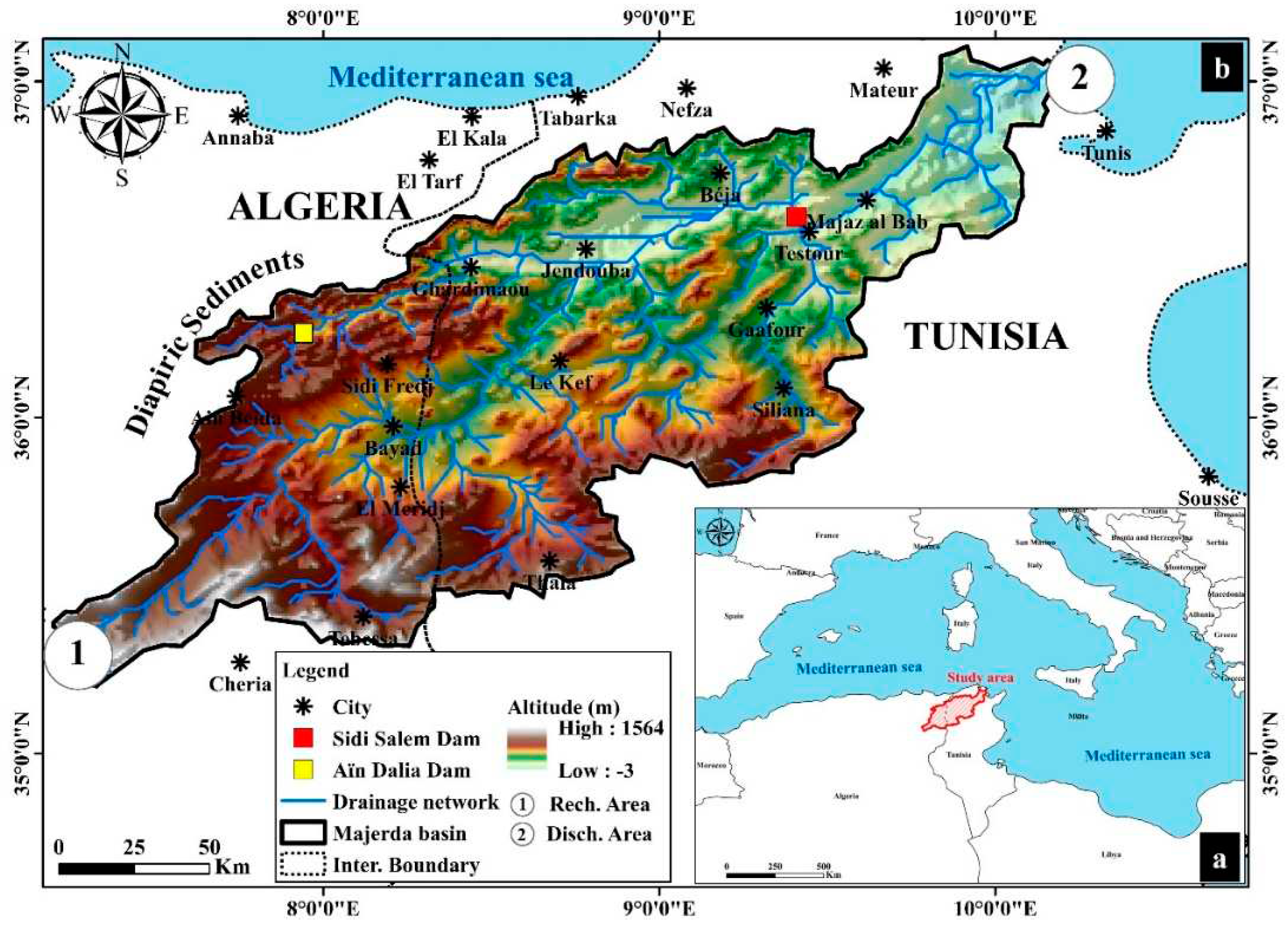
2. Study area
3. Materials and methods
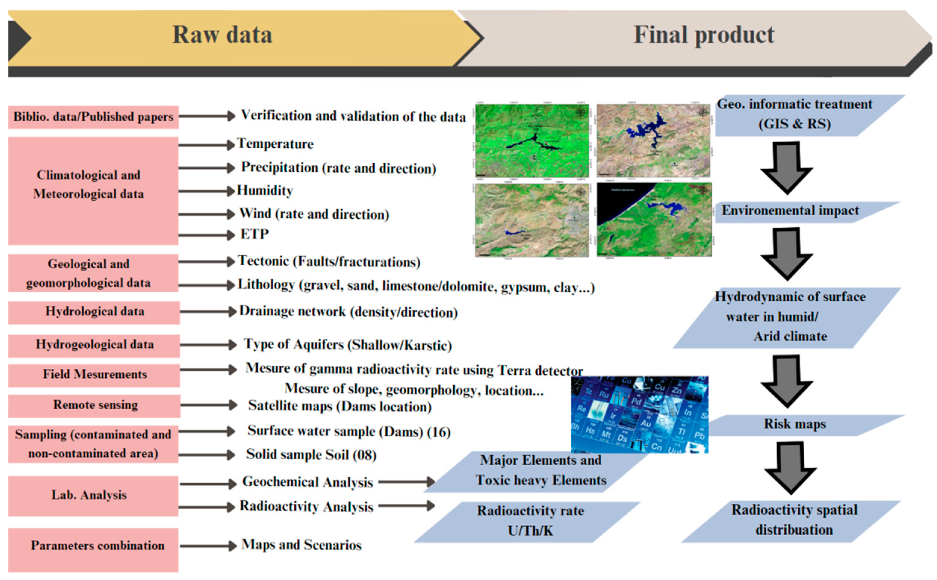
3.1. Work methodology
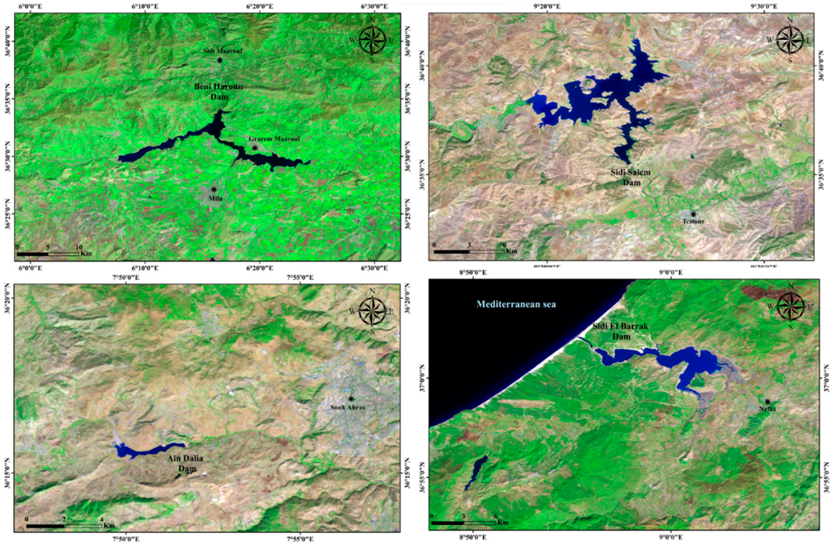
3.2. Sample collection and preparation
3.3. Gamma Counting
3.4. Ecotoxicological and radiological parameters risks
D (nGy xh-1) = 0.462 CU + 0.604 CTH + 0.0417 CK
4. Results and Discussions
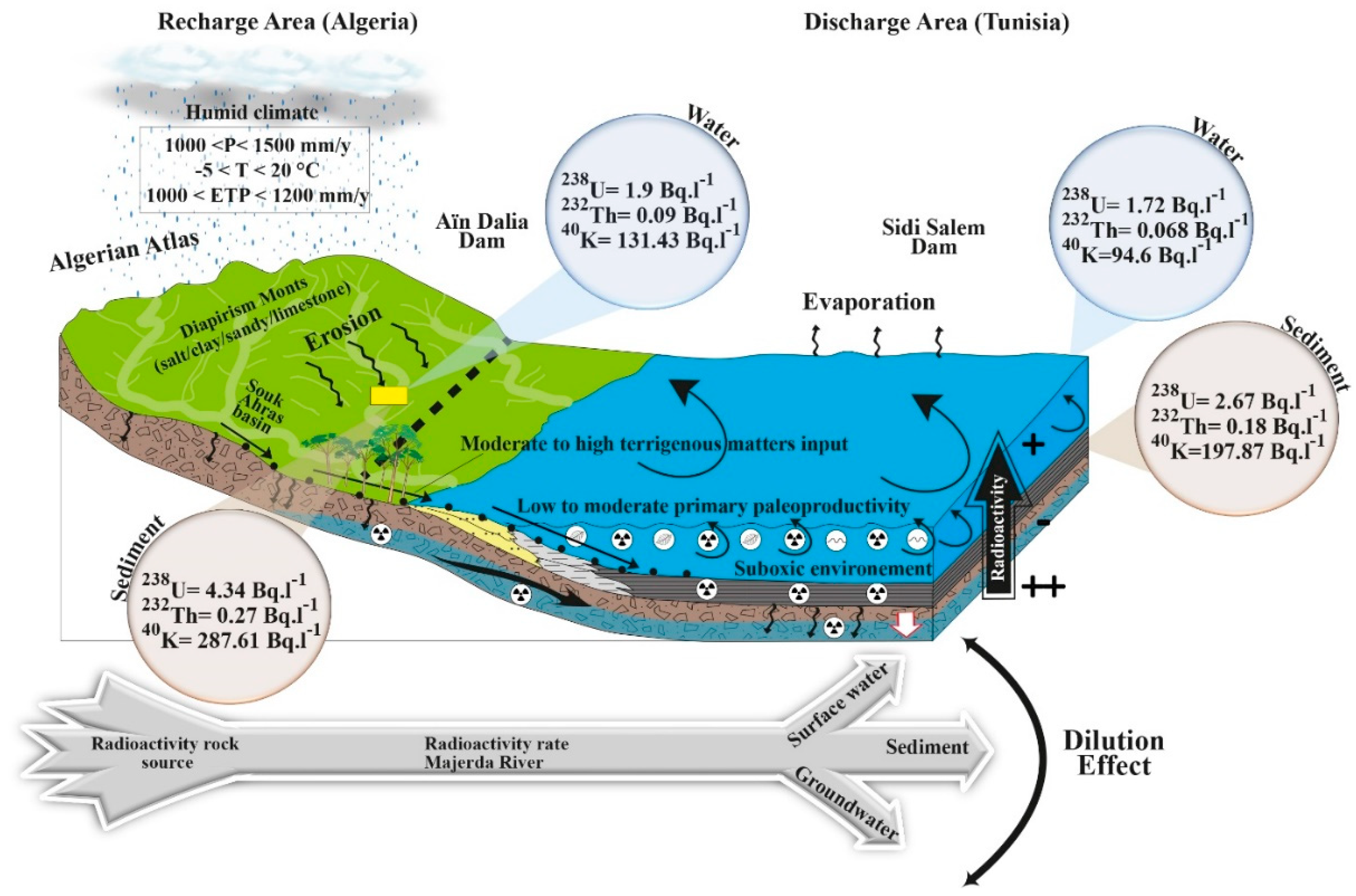
4.1. Spatial distribution of the radioactivity in the Dams
| Age Group | 0-1 | 1-2 | 2-7 | 7-12 | 12-17 | 17-25 | 25-45 | 45-65 | >65 |
| Upper side (mSvy-1) | 1.22 | 1.59 | 1.83 | 2.14 | 3.66 | 4.45 | 5.12 | 6.34 | 7.04 |
| Lower side (mSvy-1) | 0.84 | 1.09 | 1.26 | 1.47 | 2.52 | 3.06 | 3.76 | 4.12 | 5.02 |
| Word Standard value [8] | 0.12 mSvy-1 | ||||||||
234Th → 234Pa + 4He + Energy
234Pa → 234U + 4He + Energy
234U → 230Th + 4He + Energy
230Th → 226Ra + 4He + Energy
226Ra → 222Rn + 4He + Energy
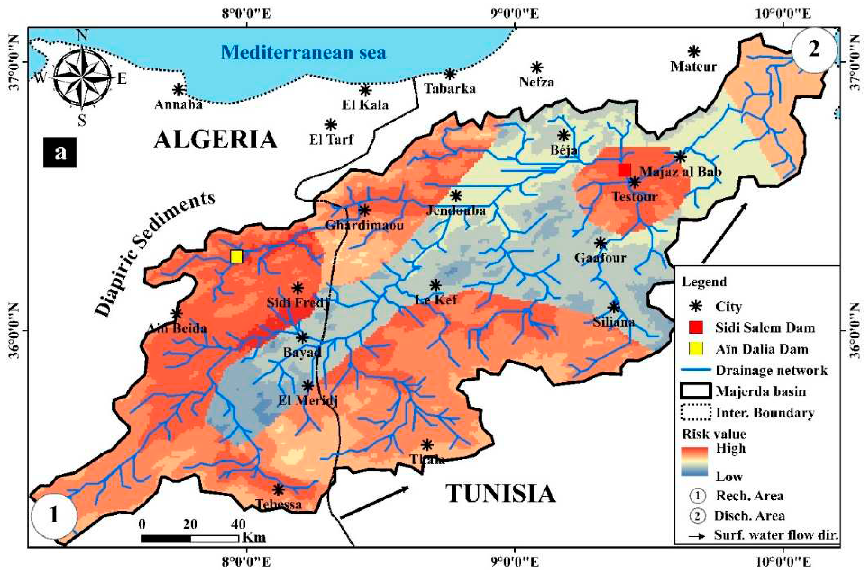
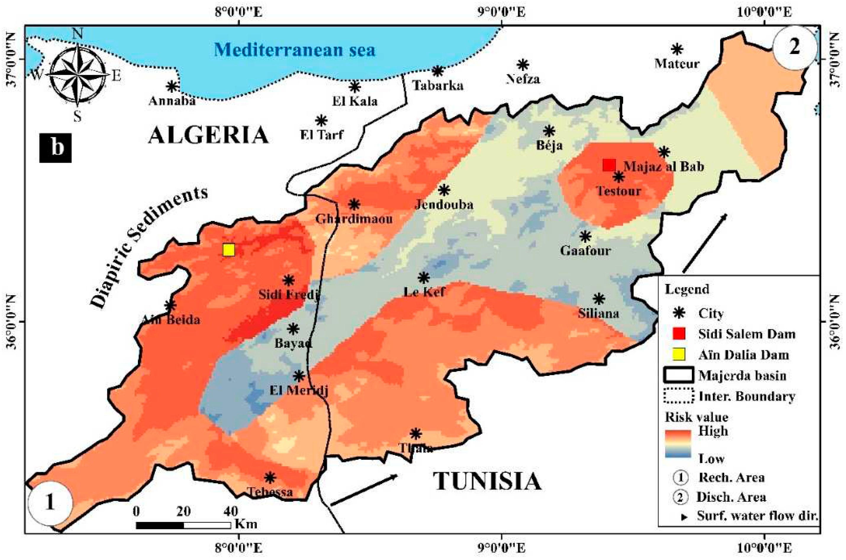
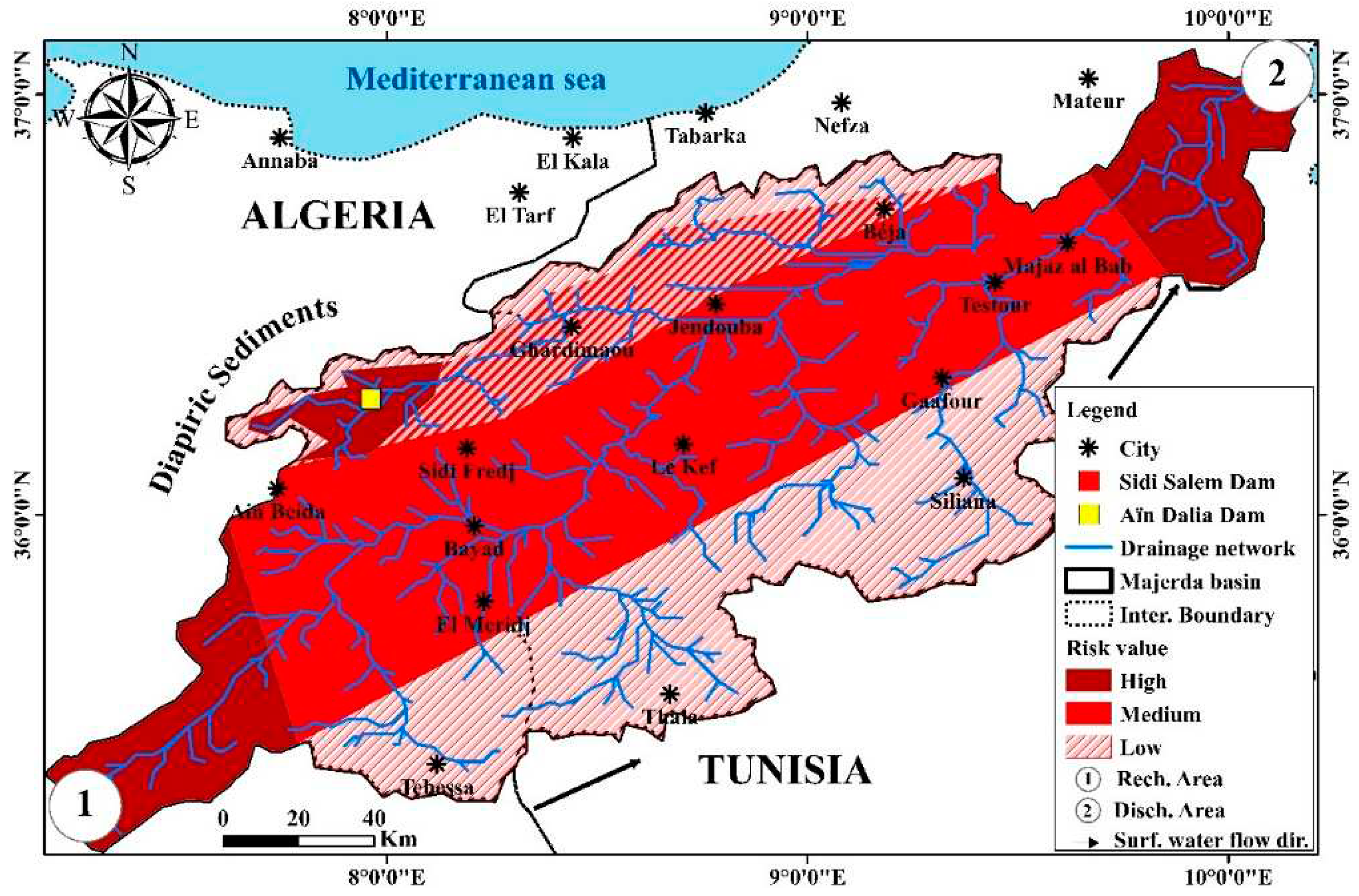
4.2. Risk map of the radioactivity distribution in the study area
4.3. Spatial distribution of the toxic heavy metals
5. Conclusion and recommendations
Author Contributions
Acknowledgments
Conflicts of Interest
References
- International Atomic Energy Agency (IAEA). Measurement of radionuclides in food and environments. A guide book, IAEA Technical Report, 1989, Series No.
- Hamed, Y. Hydrogeological, Hydrochemical and Isotopic characterization of deep groundwater in Kef Basin (NW Tunisia) Master report, Faculty of Sciences of Sfax, 2004, p 180. 2004.
- Ayadi, Y.; Redhaounia, B.; Mokadem, N.; Karim, Z.; Dhaoui, M.; Hamed, Y. Hydro-geophysical and geochemical studies of the aquifer systems in El Kef region (NW Tunisia). Carbonates and Evaporites 34, 1391–1413, 2019. [CrossRef]
- Hamed, Y.; Hadji, R.; Ncibi, K.; Hamad, A.; Ben Saad, A.; Melki, A.; Khelifi, F. Modelling of potential groundwater artificial recharge in the transboundary Algero-Tunisian Basin (Tebessa-Gafsa): The application of stable isotopes and hydroinformatics tools. 2022. [Google Scholar] [CrossRef]
- Hamad, A.; Hadji, R.; Bâali, F.; Houda, B.; Redhaounia, B.; Zighmi, K.; Legrioui, R.; Brahmi, S.; Hamed, Y. Conceptual model for karstic aquifers by combined analysis of GIS, chemical, thermal, and isotopic tools in Tuniso-Algerian transboundary basin. Arab J Geosci 11, 409, 2018. [CrossRef]
- Hamed, Y.; Khelifi, F.; Houda, B.; Ben Sâad, A.; Ncibi, K.; Hadji, R.; Melki, A.; Hamad, A. Phosphate mining pollution in southern Tunisia: environmental, epidemiological, and socioeconomic investigation. Environ Dev Sustain 2022. [CrossRef]
- Ayadi, Y.; Mokadem, N.; Besser, H.; Redhaounia, B.; Khelifi, F.; Harabi, S.; Nasri, T.; Hamed, Y. Statistical and geochemical assessment of groundwater quality in Teboursouk area (Northwestern Tunisian Atlas). Environ Earth Sci, 2018, 77, 349. [Google Scholar] [CrossRef]
- UNSCEAR, United Nations Scientific Committee on the Effects of Atomic Radiation. Sources and Effects of Ionizing Radiation, 2000, Volume I: Annex A. Dose Assessment Methodologies.
- ICRP, International Commission on Radiological Protection. Protection of the Public in Situations of Prolonged Radiation Exposure, ICRP Publication82. Ann. ICRP. 1: 29, 2000; 2. [CrossRef]
- ICRP, International Commission on Radiological Protection, Age-dependent Doses to Members of the Public From Intake Of Radionuclides: Part 5, Compilation of Ingestion and Inhalation Dose Coefficients. 1996; 72.
- WHO, World Health Organization, Guidelines For Drinking-Water Quality (4th Ed.), WHO Library Cataloguing-in-Publication Data NLM classification, Geneva, 2011 WA 675.
- USEPA, US Environmental Protection Agency, Risk Assessment Guidance For superfund. Volume I, Human Health Evaluation Manual : Part E, Supplemental Guidance for Dermal Risk Assessment), Report EPA/540/R/99/005, US Environmental Protection Agency, Washington, DC. 2014.
- El Arabi, A.M.; Ahmed, N.K; Din, K.S. Natural radionuclides and dose estimation in natural water resources from Elba protective area, Egypt. Radiat Prot Dosimetry. 2006;121(3):284-92. [CrossRef]
- Boulemia, S.; Hadji, R.; Hamimed, M. Depositional environment of phosphorites in a semiarid climate region, case of El Kouif area (Algerian–Tunisian border). Carbonates and Evaporites, 2021.36(3), 53. [CrossRef]
- Mahleb, A.; Hadji, R.; Zahri, F.; Boudjellal, R.; Chibani, A.; Hamed, Y. Water-Borne Erosion Estimation Using the Revised Universal Soil Loss Equation (RUSLE) Model Over a Semiarid Watershed: Case Study of Meskiana Catchment, Algerian-Tunisian Border. Geotechnical and Geological Engineering, 2022, 40(8), 4217-4230. [CrossRef]
- Ncibi, K.; Mastrocicco, M.; Colombani, N.; Busico, G.; Hadji, R.; Hamed, Y.; Shuhab, K. Differentiating Nitrate Origins and Fate in a Semi-Arid Basin (Tunisia) via Geostatistical Analyses and Groundwater Modelling. Water 2022, 14, 4124. [Google Scholar] [CrossRef]
- Brahmi, S.; Baali, F.; Hadji, R. , Hamad, A., Rahal, O., Zerrouki, H., Saadali, B.; Hamed, Y. Assessment of groundwater and soil pollution by leachate using electrical resistivity and induced polarization imaging survey, case of Tebessa municipal landfill, NE Algeria. Arab J Geosci 14, 249, 2021. [CrossRef]
- Ncibi, K. , Hadji, R., Hajji, S., Besser, H., Hajlaoui, H., Hamad, A., Mokadem, N.; Ben Saad, A.; Hamdi, M.; Hamed, Y. Spatial variation of groundwater vulnerability to nitrate pollution under excessive fertilization using index overlay method in central Tunisia (Sidi Bouzid basin). Irrigation and Drainage, 2021, 70(5), 1209-1226. [CrossRef]
- Fredj, M.; Hafsaoui, A.; Riheb, H.; Boukarm, R.; Saadoun, A. Back-analysis study on slope instability in an open pit mine (Algeria). Natsional'nyi Hirnychyi Universytet. Naukovyi Visnyk, 2020, № 2, 24-29, 14. [CrossRef]
- Benmarce, K.; Hadji, R.; Zahri, F.; Khanchoul, K.; Chouabi, A.; Zighmi, K.; Hamed, Y. Hydrochemical and geothermometry characterization for a geothermal system in semiarid dry climate: The case study of Hamma spring (Northeast Algeria). Journal of African Earth Sciences, 182, 2021, 104285. [CrossRef]
- Zerzour, O.; Gadri, L.; Hadji, R.; Mebrouk, F.; Hamed, Y. Geostatistics-Based Method for Irregular Mineral Resource Estimation, in Ouenza Iron Mine, Northeastern Algeria. Geotechnical and Geological Engineering, 2021, 39(5), 3337-3346. [CrossRef]
- Dib, I.; Khedidja, A.; Chattah, W.; Hadji, R. Multivariate statistical-based approach to the physical-chemical behavior of shallow groundwater in a semiarid dry climate: The case study of the Gadaïne-Ain Yaghout plain NE Algeria. Mining of Mineral Deposits, Volume 16, 2022, Issue 3, 38-47. [CrossRef]
- Akpolile, F.A.; Ugbede, F.O. Akpolile, F.A.; Ugbede, F.O. Natural radioactivity study and radiological risk assessment in surface water and sediments from Tuomo river in Burutu, delta state Nigeria. J. Nig. Ass. Math. Phys. (J. NAMP) 50, 2019, 267–274.
- Khandaker, M.U.; Uwatse, O.B.; Khairi, B.A.B.S.; Faruque, M.R.I.; Bradley, D.A. Terrestrial radionuclides in surface (dam) water and concomitant dose in metropolitan kuala Lumpur. Radiation Protection Dosimetry, Volume 185, Issue 3, 2019, Pages 343–350. [CrossRef]
- Al-Zahrani, K. H.; Baig, M. B. Water in the Kingdom of Saudi Arabia: sustainable management options. J Anim Plant Sci, 2011, 21(3), 601-604.
- Olszewska-Wasiolek, M. Estimates of the Occupational Radiological Hazard in the Phosphate Fertilizers Industry in Poland, Radiation Protection Dosimetry, Volume 58, Issue 4, , Pages 269–276. 1 March. [CrossRef]
- Pfister, H.; Philipp, G.; Pauly, H. Population dose from natural radionuclides in phosphate fertilizers. Radiation and Environmental Biophysics, 1976, 13, 247–261. [Google Scholar] [CrossRef]
- Chauhan, V. P.; Jain, R. K. Chauhan, V. P.; Jain, R. K. Strategies for advancing cancer nanomedicine. Nature Materials, 2013, 12(11), 958-962. [CrossRef]
- Guimond, R. J.; Hardin, J. M. Radioactivity released from phosphate-containing fertilizers and from gypsum. International Journal of Radiation Applications and Instrumentation. Part C. Radiation Physics and Chemistry, 1989, 34(2), 309-315. [CrossRef]
- Al Shaaibi, M.; Ali, J.; Duraman, N.; Tsikouras, B.; Masri, Z. Assessment of radioactivity concentration in intertidal sediments from coastal provinces in Oman and estimation of hazard and radiation indices. Mar Pollut Bull. 2021 Jul;168:112442. [CrossRef]
- Saad, H.R. Radioactivity concentrations in sediments and their correlation to the coastal structure in Kuwait. Volume 56, Issue 6, 2002, 991-997. [CrossRef]
- Darabi-Golestan, F. , Hezarkhani, A., & Zare, M. R. Assessment of 226Ra, 238U, 232Th, 137Cs and 40K activities from the northern coastline of Oman Sea (water and sediments). Marine Pollution Bulletin. Volume 118, Issues 1–2, 2017, 197-205. [CrossRef]
- Özmen, S. F.; Cesur, A.; Boztosun, I.; Yavuz, M. E. L. E. K. Distribution of natural and anthropogenic radionuclides in beach sand samples from Mediterranean Coast of Turkey. Radiation Physics and Chemistry. Volume 103, 2014, 37-44. [CrossRef]
- Hardman, D.J.; McEldowney, S.; Waite S, S. Pollution, ecology and biotreatment, Longman Sci. Tech. 1994. Harlow.
- Milivojevic, J.; Krstic, D.; Šmit, B.; Djekic, V. Assessment of heavy metal contamination and calculation of its pollution index for Uglješnica River, Serbia, Bull. Environ. Contam. Toxicol. 97, 2016, 737–742. [CrossRef]
- Barbee, J.Y.J.; Prince, T.S. Acute respiratory distress syndrome in a welder exposed to metal fumes, South. Med. J. 92, 1999, 510–520. [CrossRef]
- Aleksandra, D.; Urszula, B. The impact of Nickel on human health, J. Elementol. 13 (4), 2008, 685–696.
- Adimalla, N.; Wu, J. Groundwater quality and associated health risks in a semi-arid region of south India: implication to sustainable groundwater management, Hum. Ecol. Risk Assess: An Int. J. 25 (1–2), 2019, 191–216. [CrossRef]
- Hamed, Y.; Dassi, L.; Ahmadi, R.; Ben Dhia, H. Geochemical and isotopic study of the multilayer aquifer system in the Moulares-Redayef basin, southern Tunisia. Hydrol Sci J. 2008, 53(5):1241–1252. [CrossRef]
- Stumm, W.; Morgan, J.J. Aquatic Chemistry: An Introduction Emphasizing Chemical Equilibria in Natural Waters. 1981, 2nd edn., J.
- US Environmental Protection Agency 2000. Radionuclides Rule: A Quick Reference Guide.

| Location/country |
D (nGyh-1) |
Raeq (Bqkg-1) |
Hext | Hint |
AGED (μSvy-1) |
| Aïn Dalia dam/Algeria | 14.12 | 36.79 | - | - | 104.53 |
| Sidi Salem dam/Tunisia | 9.59 | 18.16 | - | - | 71.13 |
| World standard value [8] | 57.00 | 370.00 | 1.00 | 1.00 | 1.00 Svy-1 |
| Region/Country | 238U, Bq kg-1 | 232Th, Bq kg-1 | 226Ra, Bq kg-1 | 40K, Bq kg-1 | Reference |
| Sidi Salem Dam (Water)/Tunisia | 1.72 | 0.068 | - | 94.6 | Present study |
| Sidi Salem Dam (Sediment) /Tunisia | 2.67 | 0.18 | - | 197.87 | Present study |
| *Sidi El Barrak Dam (Water)/Tunisia | 0.82 | 0.032 | - | 67.98 | Present study |
| *Sidi El Barrak Dam (Sediment)/Tunisia | 0.45 | 0.024 | - | 45.62 | Present study |
| Aïn Dalia Dam (Water) /Algeria | 1.9 | 0.09 | - | 131.43 | Present study |
| Aïn Dalia Dam (Sediment) /Algeria | 4.34 | 0.27 | - | 286.61 | Present study |
| *Beni Haroun Dam (Water/Algeria) | 0.7 | 0.04 | - | 98.7 | Present study |
| *Beni Haroun Dam (Sediment/Algeria) | 0.52 | 0.03 | - | 75.4 | Present study |
| Gafsa Phos.Rock/Tunisia | 702 | 75 | 911 | 90 | [6] |
| Tunisia | - | 29 | 821 | 32 | [26] |
| Egypt | 686 | 5.7 | 656 | 68.6 | [13] |
| Morocco | - | 20 | 1600 | 10 | [27] |
| Algeria | - | 64 | 619 | 22 | [28] |
| Saudi Arabia | - | 17-39 | 64-513 | 242-2453 | [24] |
| Germany | - | 15 | 520 | 720 | [27] |
| USA | - | 49 | 780 | 200 | [29] |
| India | - | 65 | 120 | 2624 | [28] |
| Jordan | - | 2 | 1044 | 8 | [26] |
| Kuala Lampur-Malaysia | - | 1.2 | - | 35.1 | [24] |
| Buruta-Nigeria | - | 26.9 | - | 61 | [23] |
| Oman | - | 2.26 | 20.49 | 44.83 | [30] |
| Kuwait | - | 6 | 36 | 227 | [31] |
| Iran | - | 17.61 | 14.96 | 361.6 | [32] |
| Turkey | - | 9.0 | 12.2 | 157.7 | [33] |
| Contaminant | Maximum contaminant levels |
| Uranium | 30 microg/l |
| Combined Rn-226 and Ra-228 | 5 pCi/l (0.185 Bq/l) |
| Gross alpha (excluding Rn and U but inclusding Ra-226) | 15 pCi/l (0.555 Bq/l) |
| Beta particle and photon radioactivity | 40 mrem/y (0.04 mSv/y) |
| 238U | 232Th | 40K | Fe | Pb | Zn | Ni | Cu | Cr | Cd | |
| Dalw2 | 1.90 ± 0.24 | 0.09±0.01 | 131.43±1.03 | 5.430 | 0.0980 | 0.087 | 0.024 | 0.063 | 0.015 | 0.025 |
| Dals3 | 4.34±0.05 | 0.27±0.05 | 287.61±3.34 | 201.9 | 5.88 | 5.046 | 0.216 | 0.441 | 0.06 | 0.20 |
| Dtnw4 | 1.72±0.01 | 0.068±0.01 | 94.6±1.04 | 9.700 | 0.065 | 0.061 | 0.018 | 0.043 | BDL1 | 0.130 |
| Dtns5 | 2.67±0.01 | 0.18±0.012 | 197.87±2.01 | 136.7 | 3.41 | 3.22 | 0.182 | 0.213 | BDL1 | 0.15 |
| WHO limits | 1.0 | 0.1 | 10.0 | 0.01 | 0.07 | 2.00 | 0.05 | 0.003 |
Disclaimer/Publisher’s Note: The statements, opinions and data contained in all publications are solely those of the individual author(s) and contributor(s) and not of MDPI and/or the editor(s). MDPI and/or the editor(s) disclaim responsibility for any injury to people or property resulting from any ideas, methods, instructions or products referred to in the content. |
© 2023 by the authors. Licensee MDPI, Basel, Switzerland. This article is an open access article distributed under the terms and conditions of the Creative Commons Attribution (CC BY) license (http://creativecommons.org/licenses/by/4.0/).


