1. Introduction
The introduction should briefly place the study in a broad context and highlight why it is important. It should define the purpose of the work and its significance. The current state of the research field should be carefully reviewed and key publications cited.
The number of enclosures in SE, Central Europe and beyond is constantly growing, and the variety of purpose(s) of these large and complex earthworks and its interpretation remains very active research question both on local a pan-European scale [
1,
2,
3,
4,
5,
6].
Application of remote sensing techniques in the last three decades slowly enabled the broadening of the research areas and observation of Late Neolithic sites on much larger scales e.g., [
7,
8,
9,
10,
11]. This led to the changes in understanding of the size and scope of Neolithic settlements and/or monuments. Period of late Neolithic in Eastern Croatia is traditionally marked by the presence of Sopot culture. So far, the data of the size and internal organization of the landscape are rather limited which allowed only most general and generic conclusions, even though some sites with complex structure were mentioned, and also possibility of mutual relations, but were not further elaborated [
12,
13]. Previously known, eponym Sopot culture site which was systematically excavated in the last 25 years also has enclosure confirmed by excavations and magnetic survey [
13]
It was presumed that the sites with enclosures during the late Neolithic are tell sites in traditional sense with limited to a geographic and temporal expansion. [
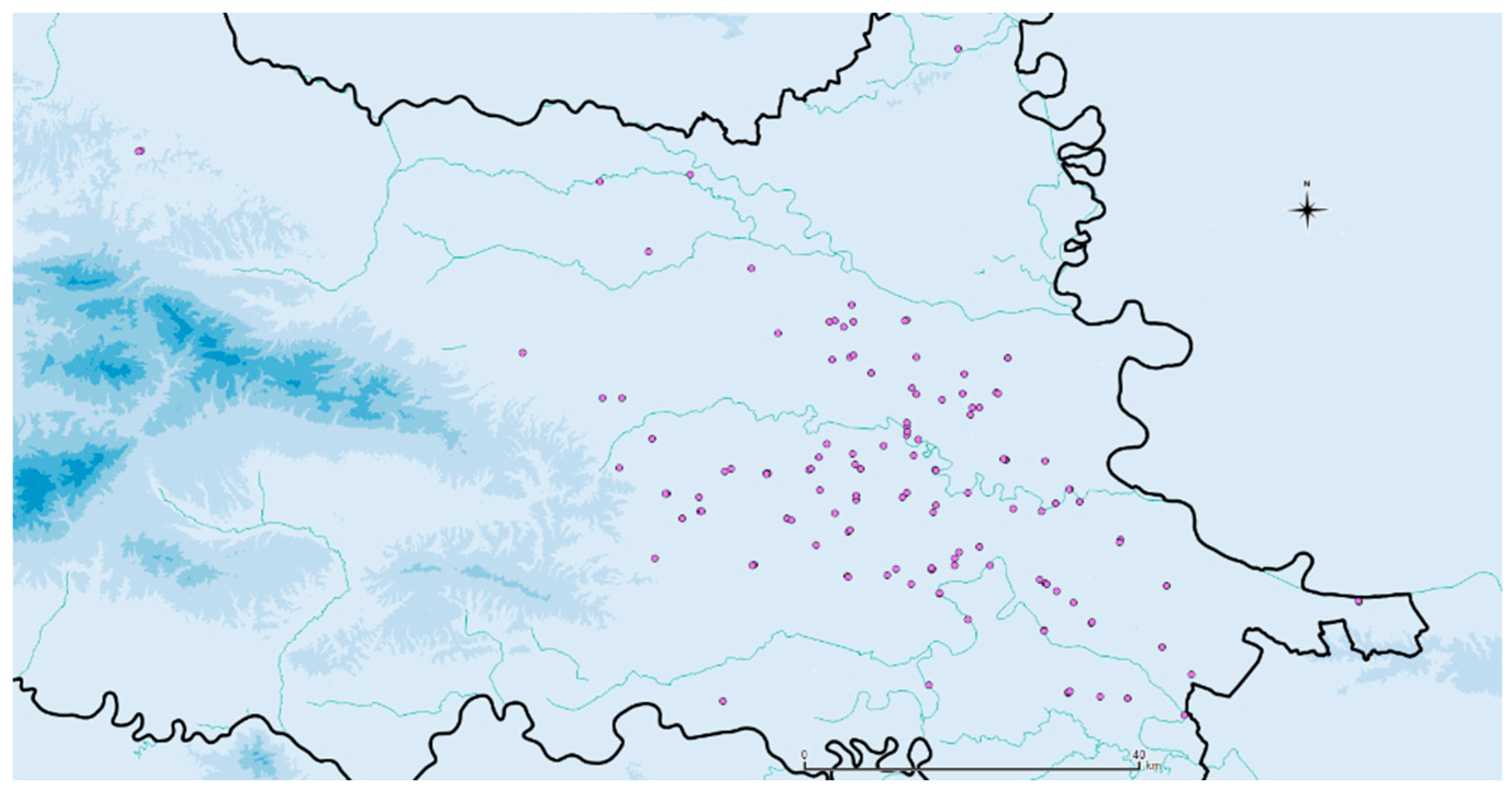
14] This new results are yet to change this traditional image. Results of a ten year remote sensing research followed by field surveys confirmed the presence of more than 100 late Neolithic circular enclosures on the territory of Eastern Croatia [
15,
16,
17,
18,
19,
20] (
Figure 1). On 5 of them geomagnetic surveys confirmed presence of enclosure(s), but also very dense and complex features.
The multiscale research on Gorjani Topole and nearby Gorjani Kremenjača locations revealed complex spatial organization and directed the research towards the search for the actual size of the settlement and its internal organization. Current results urge us to form hypothesis of the existence of settlement planning and settlement templates during the late Neolithic in the area. Also, it is clear that this new information will require much focused research in order to understand specific features or complexes of features.
2. Materials and Methods
Aerial reconnaissance
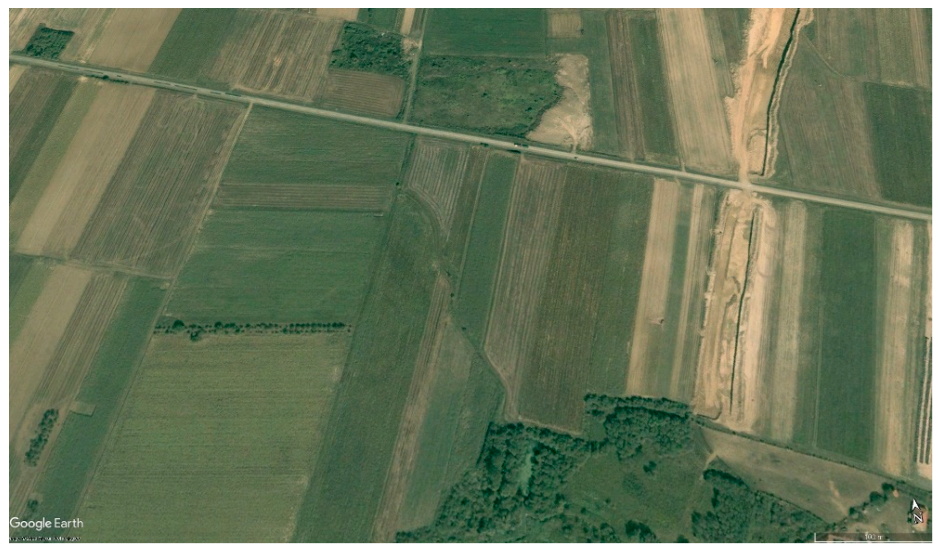
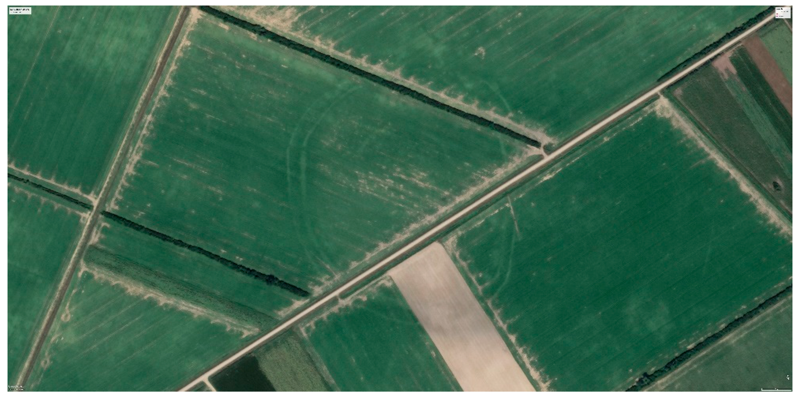
Enclosures of Gorjani Topole were initially observed on the Google Earth image from August 2007 (
Figure 2). On this image crop marks of three ditches are clearly visible. This is also the only image where the fragment of outer ellipsoidal ditch is visible.
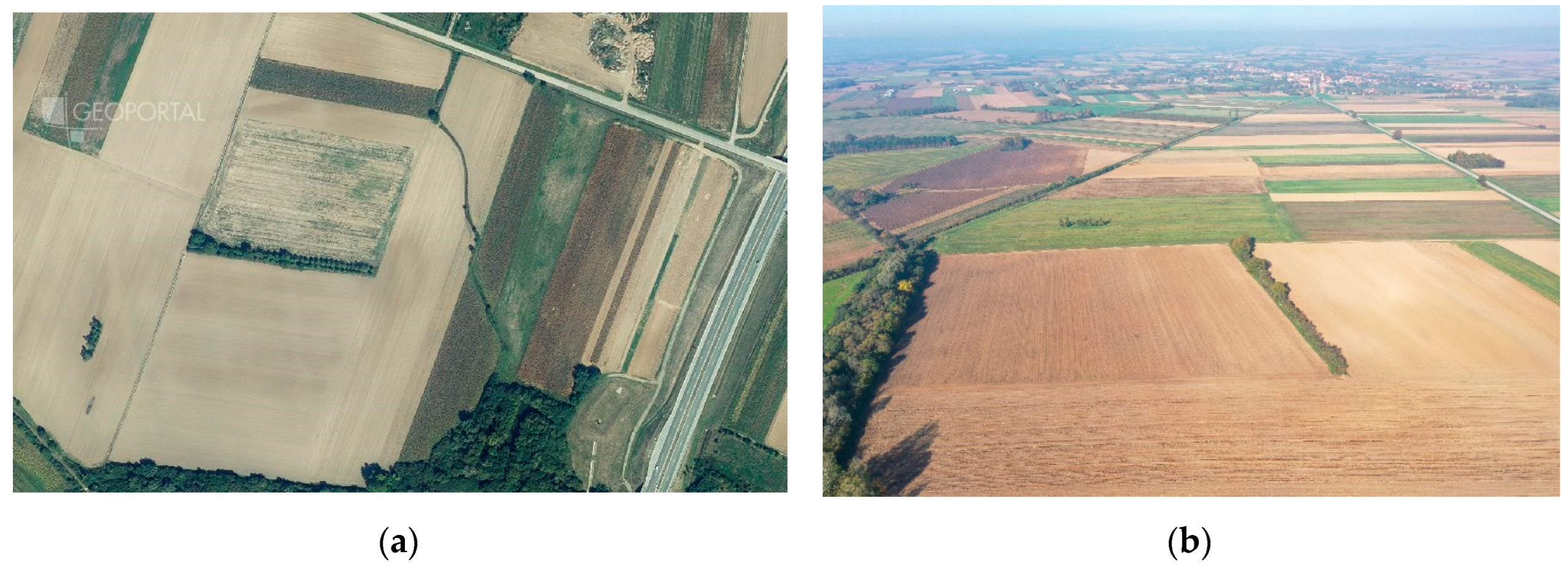
Subsequent images do not reveal the details as the 2007 one, but the area of circular enclosure is clearly visible as soil mark on later Google Earth images and also orthophotos from Croatian State Geodetic Administration, for example the one from 2014 and on drone images (
Figure 3), ), or isn’t so clearly visible as crop marks on obliqe images shoot from airplane in 10. 06. 2015 [
16].
Field survey
Following the observations, we conducted a series of intensive field surveys (2015, 2016, 2017) where pottery fragments and lithic artifacts from Neolithic (both Starčevo and Sopot culture) period were collected. After the geomagnetic survey, we decided to encompass larger area for research, to the east.
Expansion of field survey area revealed places with high concentration of Neolithic pottery and lithic finds so we focused the geomagnetic survey to that area also.
Geomagnetic survey
Geomagnetic survey was conducted on several occasions from 2019 till 2023 by the company cm prospection from Berlin. Arrays of Förster fluxgate gradiometer probes with 7 sensors were used for the magnetic measurements. The probes were mounted on a light and foldable cart and moved by hand. The Förster FEREX CON650 fluxgate gradiometer probes register the vertical gradient of the vertical component of the Earth’s magnetic field with an accuracy of 0.1 nT (Nanotesla). The measured gradient (the difference between two vertically arranged sensors in the gradiometer probe) is insensitive to the typically large fluctuations of the Earth’s magnetic field and is determined only by the magnetization of local subsurface objects. The data positioning for the magnetic survey was realized by means of differential GPS, using two GNSS receivers Trimble R10 model 2 in RTK mode (Real-Time Kinematic) to achieve a relative accuracy of 2 cm. The base was fixed via Trimble RTX corrections to an absolute accuracy of 2 cm. The coordinate system used during the magnetic measurements was WGS84 UTM 34N (EPSG: 32634). Subsequently, the data were reprojected to the reference system HTRS96 / Croatia TM (EPSG: 3765) by means of the open source Geospatial Data Abstraction Library (GDAL) [
21,
22].
Archaeological excavation
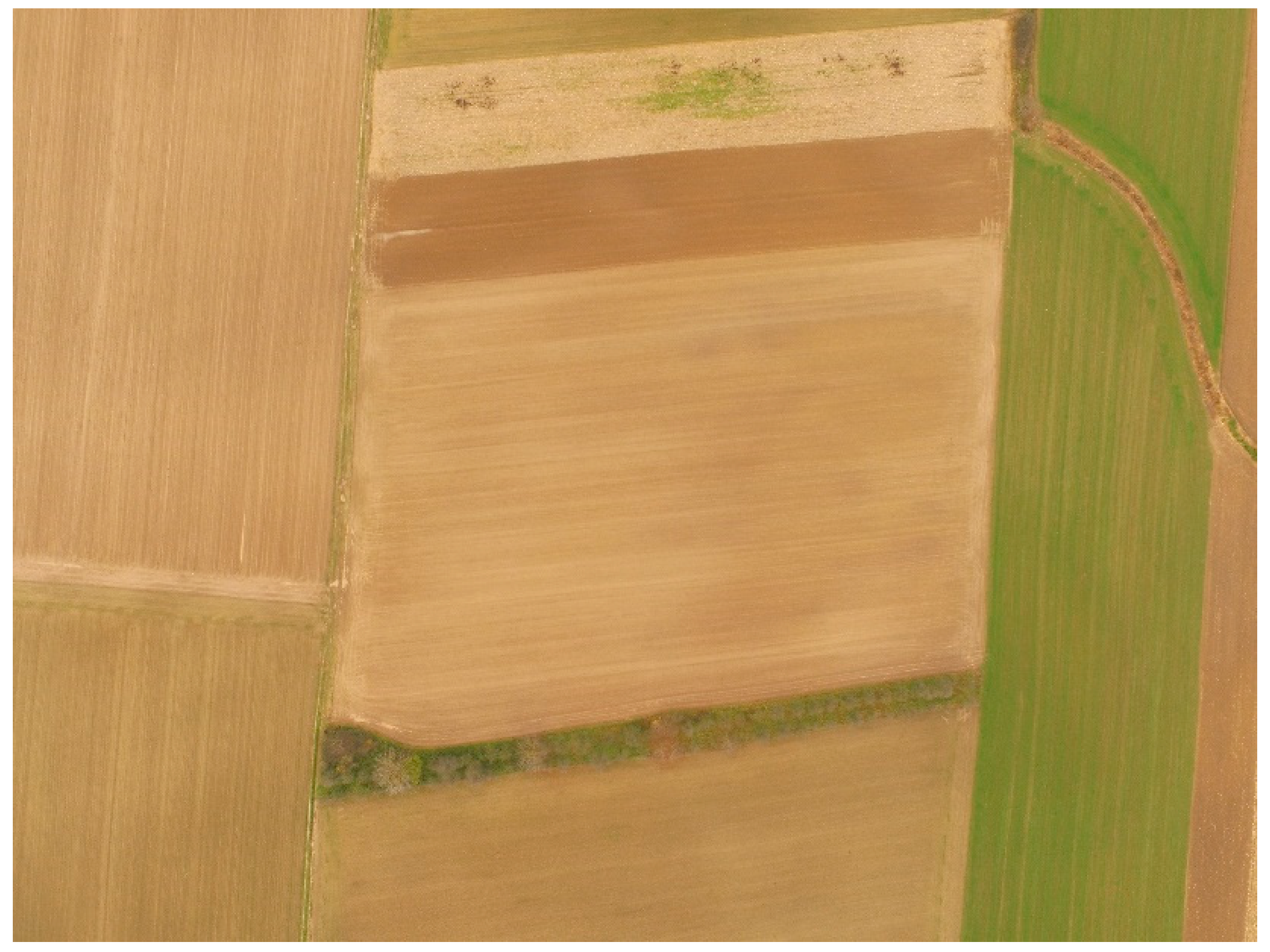
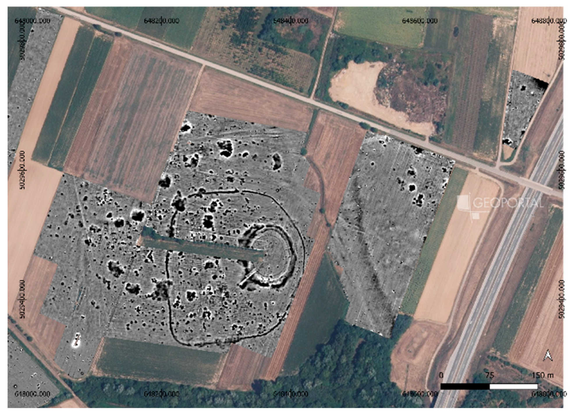
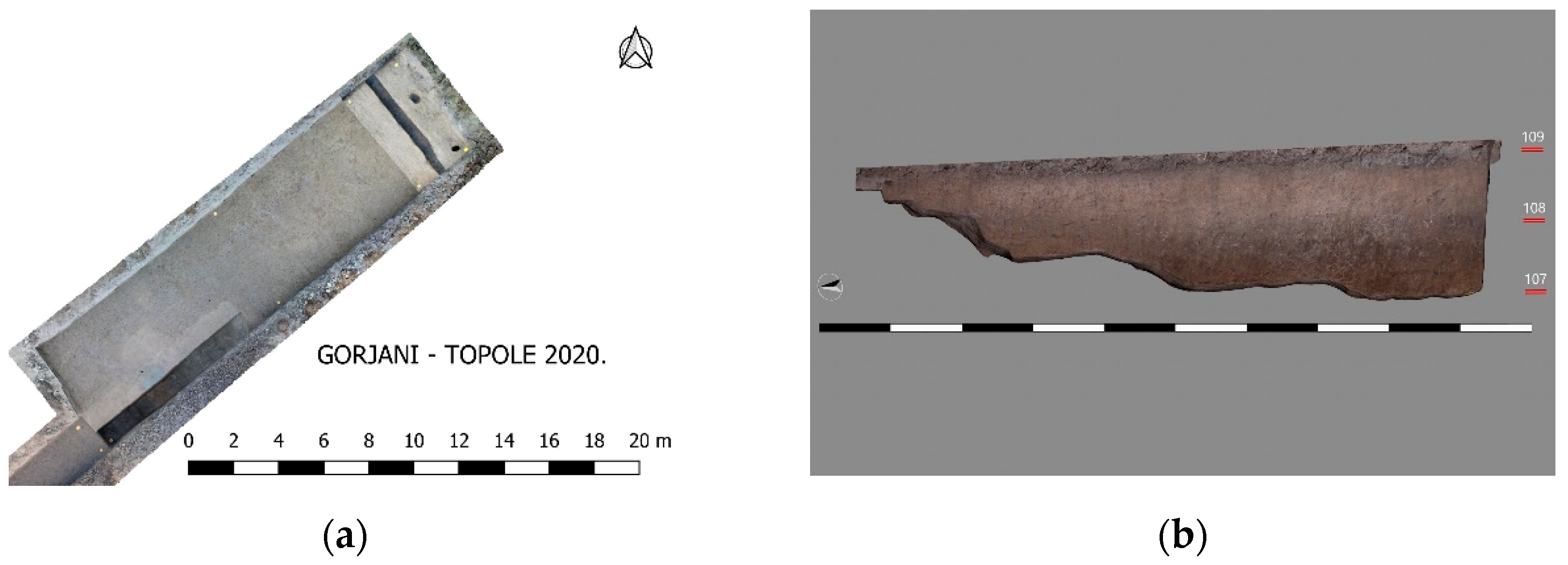
Archaeological excavation on the position of Gorjani Topole have been carried out twice so far, in March 2020 and 2021. The 2020 research was planned to confirm the presence of the ditches that was observed on satellite and aerial images, which was also confirmed by magnetometric surveys (
Figure 4,
Figure 5 and
Figure 6). A trench was chosen with the intention of excavating the remains of circular ditches and a palisade that were visible on magnetometric and aerial images. During March 2020, archaeological excavations were carried out at the site of one of the houses that were recorded on magnetometric images. Due to the feasibility of the research, one of the smaller houses was chosen (
Figure 6).
3. Results
3.1. Archaeological Interpretation Based on Aerial and Satellite Images
Initial archaeological interpretation based on remote sensing presumed triple ditch enclosure. Due the third outer ditch only partly visible and distance between ditches on we interpret as triple ditch. And this will stall until geomagnetic survey. On one drone images it was visible dark spot which were an indication that archaeological remains could also be found in the area surrounding enclosure. The results of the aerial and satellite studies yielded significant results, considering dozens of images from 2002 to the present day, including an archival image from 1968. It confirmed the presence of circular enclosure and which motivated further research.
Most recent archaeological excavation confirmed the expansion of the late Neolithic features outside the already established area. Re-examination of satellite images based on the results of field survey and geomagnetic survey allowed us to observe possible pit features that were as soil marks inconclusive. But with comparison with field survey results and geomagnetic survey new possible pits were revealed which was then tested by the new geomagnetic survey. It confirmed presence of large pits, and also a longhouse.
3.2. Geomagnetic Survey
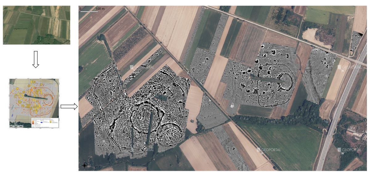
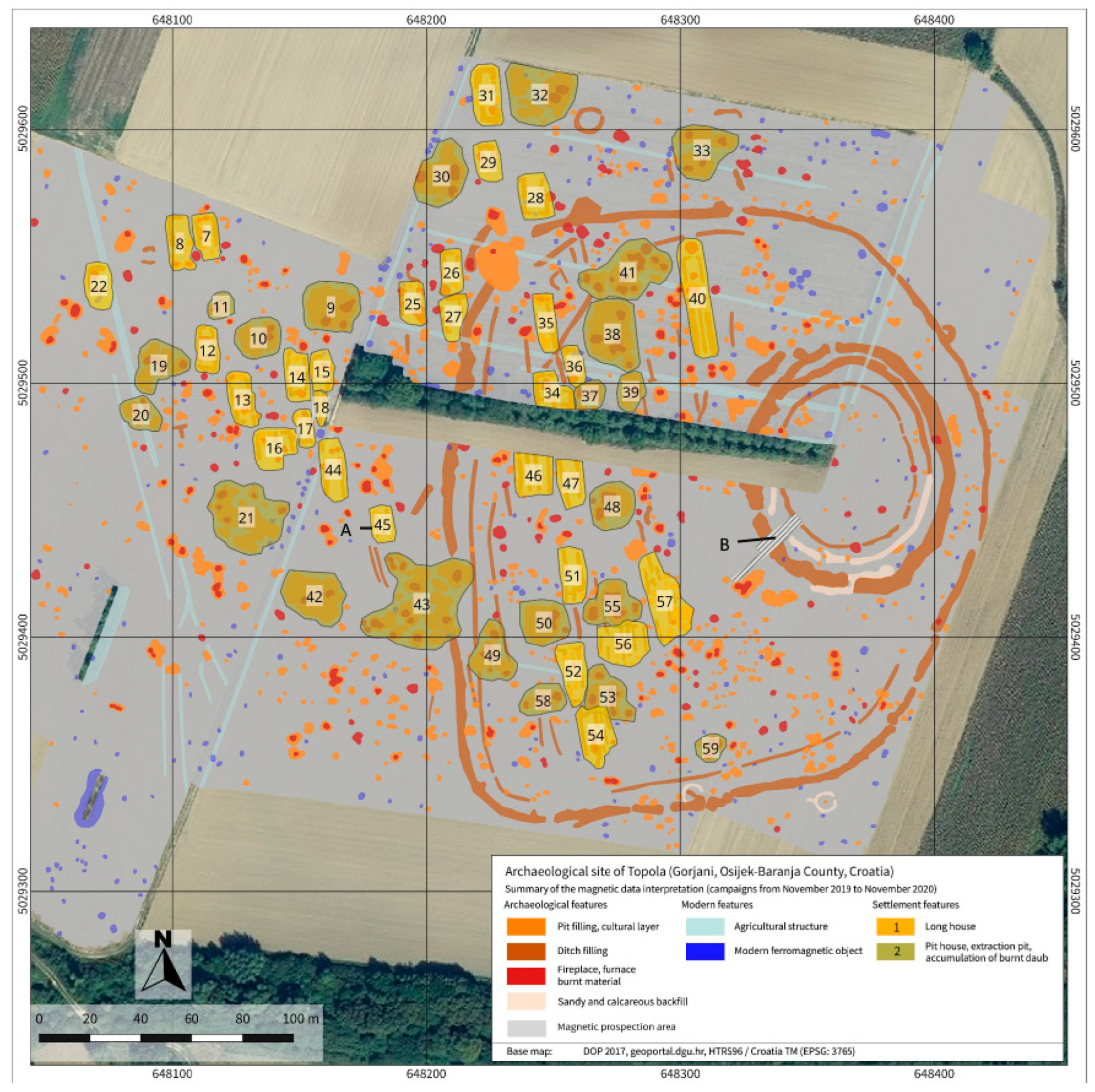
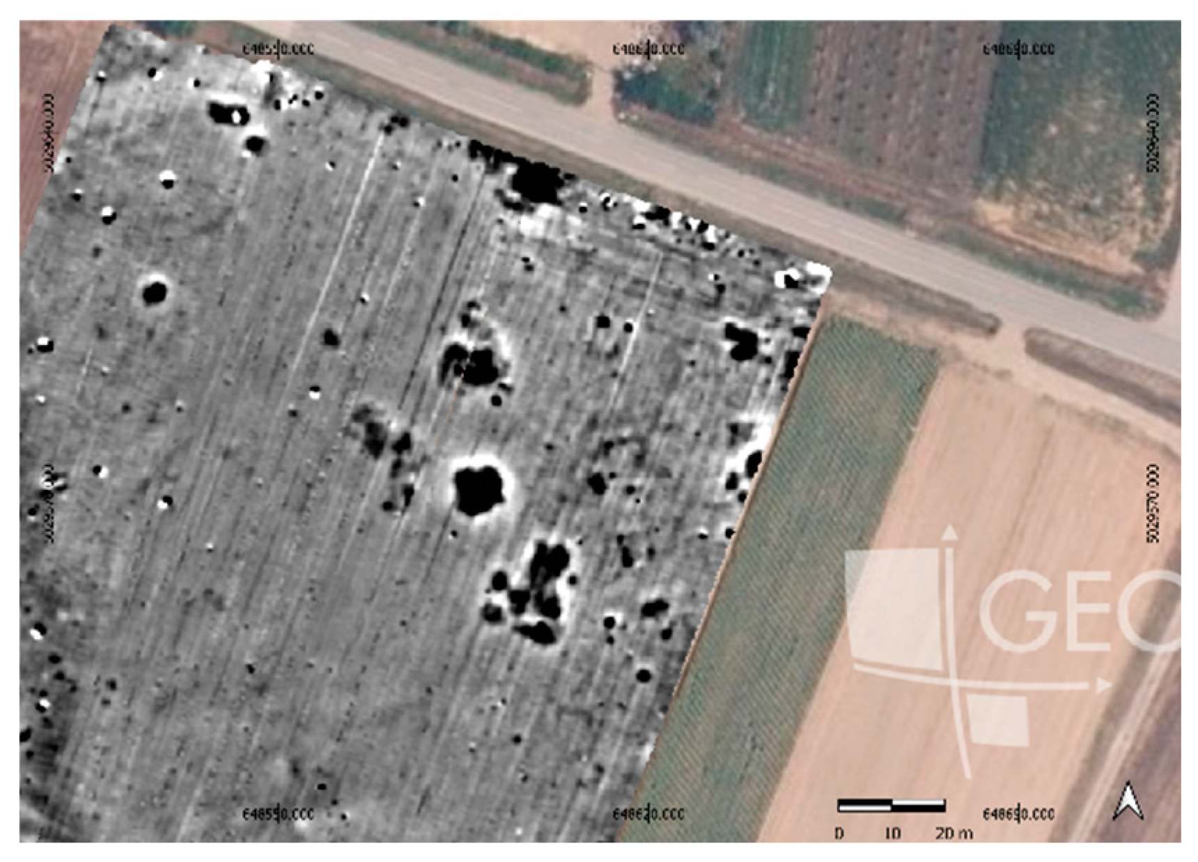
Geomagnetic survey initially covered area of over 10 ha. It confirmed the presence of three ditches – two circular and one ellipsoidal, but also a circular palisade in the inner part of the circular enclosure (
Figure 3). Furthermore, it revealed the presence of larger ellipsoidal enclosure and presence of numerous features spreading toward the north and west of the enclosure(s).
Most recent geomagnetic survey, planned according to the results of field survey and new satellite image observations, confirmed the expansion of the site to the east and the presence of the long house. We can assume that this is close to the border of the site since there is motorway during which construction archaeological sites were found to the north and south of this position, but not in the continuation of this site [
23,
24], so it is reasonably to assume that the eastern edge of the Topole settlement is somewhere near this longhouse .The orientation of the longhouse at the most eastern part is the same as of the rest of them in the area to west of the circular enclosure (
Figure 7).
3.3. Archaeological Excavation
The excavations revealed that below the ploughed layer, there is a natural layer of thickness 0.5 – 0.8 m at this site, below which archaeological structures occur. The occurrence of such layers was recorded at the nearby Tomašanci – Palača site, which is located only 500 m to the north and was investigated during protective archaeological work during the construction of the A5 motorway [
23]. Fragments of pottery from the Sopot culture were found in those layers at that site, and it was presumed that there was a Sopot culture settlement somewhere nearby [
25], which was confirmed by this research. The excavations revealed the remains of two ditches and a wooden palisade (
Figure 6). While the internal ditch is relatively shallow and has homogenous fills, the external ditch is of bigger depth (more than 2 m) and width and contains several fills (
Figure 8b), which would mean that the ditch were filled slowly over time [
26], and were probably exposed to atmospheric and depositional processes that did not occur evenly and simultaneously on all parts of the excavated ditch. The ceramic fragments are very fragmented and washed out, which is another argument that the ditch stood open for a longer period before being filled, so the material is extremely damaged by atmospheric action and later post-depositional processes. Like today, waste was probably occasionally dumped in the channels, which the structure of the found material also indicates. Preliminary thin section analysis also indicates multiple fillings of the ditch: alternating two homogenous sediments without or with very little anthropogenic material, or only occasionally appearing organic matter when the channel was filled relatively quickly, and two sediments with more anthropogenic material that includes fragments of housewares, ceramics, coal, organic matter.
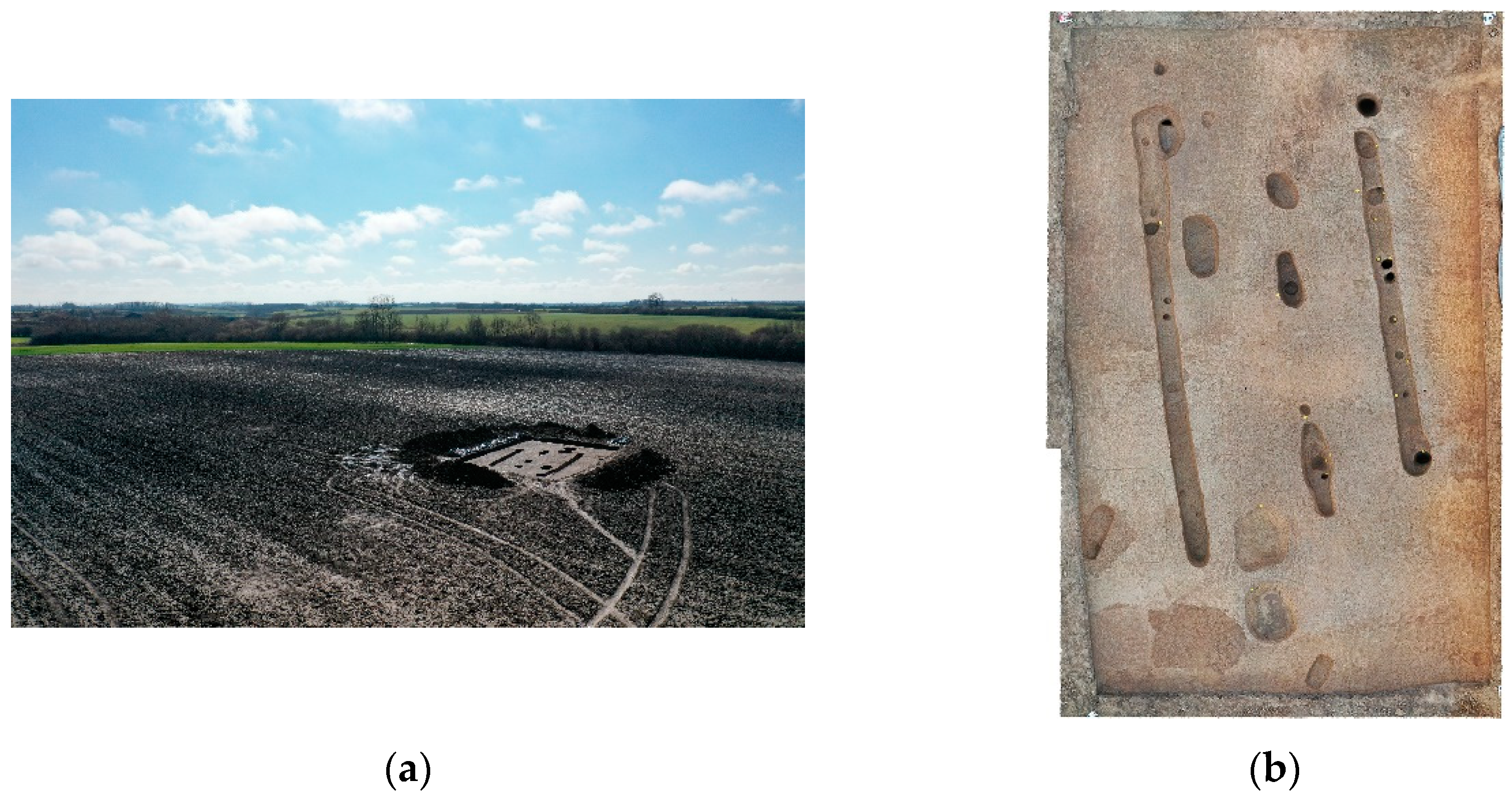
The remains of the house were preserved as negatives of channels and holes from the columns of its original wooden construction (
Figure 6). Since the house was abandoned and slowly deteriorating, there were not many finds, only a small amount of fragments of ceramic vessels from the Sopot culture.
Figure 9.
(a) Oblique drone image of excavated house. DJI Mavic Pro2, 15.03..2021. Author: Rajna Šošić Klindžić. (b) ortophoto of excavated house.
Figure 9.
(a) Oblique drone image of excavated house. DJI Mavic Pro2, 15.03..2021. Author: Rajna Šošić Klindžić. (b) ortophoto of excavated house.
Radiocarbon dates confirm attribution of the site to the Late Neolithic period. For the chronological attribution of the site, 12 samples of bone and charcoal were dated by AMS radiocarbon at Hertelendi Laboratory of Environmental Studies, Debrecen, Hungary. The samples originate from four contexts: excavated remains of the house, the postholes of the palisade, the circular inner ditch and circular outer ditch. Due to the very poor preservation, we managed to date only three bones samples, others are charcoal. The results of radiocarbon dating place all the features in the period of late Neolithic, to its later phases (
Table 1). Dates from the outer ditch belong to the latest for the Neolithic in the area, even the beginning of the Eneolithic on the nearby Lasinja culture site [
25], and similar date from the posthole of the house suggest occupancy of the site in the final phases of Neolithic in the area. As mentioned before, ditch was probably filled during the longer period of time. Other dates are concentrated in the period c. 4800-4500 which suggest long duration of the settlement.
Nearby complex of several circular and ellipsoidal enclosures Gorjani Kremenjača also suggest long duration of the settlement and in part overlaps with dates for Topole rondel and house [
16].
4. Discussion
We suggest the interpretation of the circular enclosure as rondel since it has clearly marked entrances, it is mostly empty space and is constructed of series of parallel ditches and palisades and entrances. The spatial relationship of this rondel to other ditches and other archaeological features are the focus of our future research. Rondels that are surrounded by the simple ditch (usually ellipsoidal) are documented in other regions as well, for example, in Germany Ippesheim,, Künzing-Unternberg and similar sites [
27], or Bylany in Chech republic [
28]. Such rondels with surrounding ditches are discovered in Croatia also on sites of Gat-Svetošince [
15], Privlaka-Gradina [
13,
17], Klisa Groblje i Brdo [
17] and Markušica – Brošov Salaš (
Figure 10).
The datation and duration of the rondel and settlement are also in accordance with other European rondels [
27,
28,
29]. The orientation of the houses is northwest-southeast (
Figure 6) which is common for the area and time period as defined in recent research [
30] Acceptance and respect of the empty space in the rondel is also suggested by the fact that it remained as such which is not the case for the other part of the site where overlapping of features is documented on numerous places (
Figure 6).
This research is complimentary with recent new results where it is proven that remote sensing enable discovery of many Neolithic rondel sites in area where they were not previously documented, like Poland [
31], and the remote sensing is efficient and reliable methodology for new site detection that provides better insight in cultural landscapes and enables research on bigger scale. Multi-rondel sites are also documented in wider Central-European context [
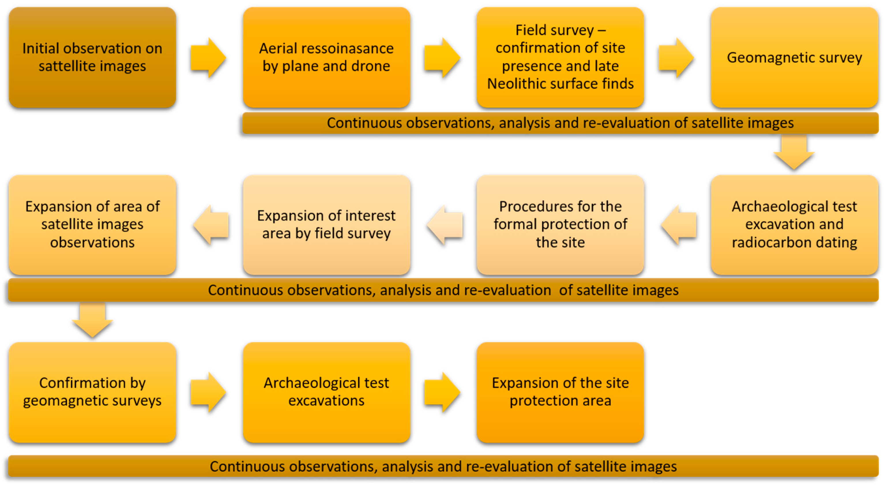
29]. Sites with multiple enclosures and rondels quite close to each other are documented at multiple places through continuous monitoring explained in
Figure 11 that enabled observation of new sites [
32]. With the most recent research, it is established that the complex of Neolithic settlements and features in Gorjani is even larger that established [
33] so it covers the area of 1500 m in length, encompassing the are of c. 70 hectares (
Figure 11). This partial temporal overllaping is important factor for understanding the cultural landscape in early to mid 5
th millennium BC. Higher resolution research will provide us with more information to conclude whether this is Late Neolithic landscape or Late Neolithic settlement. In both cases, but especially the latter, this approaches urges us to expand our area of research and understanding of spatial organization in Late Neolithic.
Results of remote sensing multiscale and multitemporal research the Croatian Ministry of Culture and Media to start the procedure of protection of the entire area as cultural heritage site in its total.
Figure 11.
Workflow established for detection of Late Neolithic enclosures in Eastern Croatia.
Figure 11.
Workflow established for detection of Late Neolithic enclosures in Eastern Croatia.
Figure 12.
Results of geomagnetic survey at Gorjani Kremenjača and Topole 2018-2023.
Figure 12.
Results of geomagnetic survey at Gorjani Kremenjača and Topole 2018-2023.
Author Contributions
Conceptualization, RŠK, BŠ, HK.; methodology, BŠ, HK, RŠK.; investigation, RŠK, BŠ, HK.; resources, RŠK, BŠ, HK.; writing—original draft preparation, RŠK, BŠ, HK writing—review and editing, RŠK, BŠ, HK; funding acquisition, RŠK, BŠ, HK. All authors have read and agreed to the published version of the manuscript.
Funding
This research was funded by the Croatian Science Foundation, IP-2019-04-5344.
Data Availability Statement
Data is contained within the article.
Acknowledgments
This research would not be possible without the support of the County of Gorjani and its Commissioner, Ivan Lović to whom we express our big gratitude. We are thankful to Cornelius Meyer from cm prospection for the geomagnetic survey, Marin Mađerić and Miroslav Vuković for documentation and data processing, Katarina Gerometta for gearchaeological research and all kind of support, Tomislav Hršak for support and all the researchers and students who participated in the fieldwork.
Conflicts of Interest
The authors declare no conflict of interest. The funders had no role in the design of the study; in the collection, analyses, or interpretation of data; in the writing of the manuscript; or in the decision to publish the results.
References
- Gaydarska, Bisserka; Chapman, John; Otte, Marcel. The archaeology of Europe megasites in prehistoric Europe. Cambridge University Press: Cambridge, UK, 2022.
- Řídký, J.; Květina, P.; Limburský, P.; Končelová, M.; Burgert, P.; Šumberová, R. Big Men or Chiefs? Rondel Builders of Neolithic Europe; Oxbow Books: Oxford, UK; Philadelphia, PA, USA, 2018.
- Pasztor, E.; Barna, J.P.; Zotti, G. Neolithic Circular Ditch systems (“Rondels”) in Central europe. In Handbook of Archaeoastronomy and Ethnoastronomy; Ruggls, C.N., Ed.; Springer: New York, NY, USA, 2015; pp. 1317–1326.
- Hofmann, R.; Medović, A.; Furholt, M.; Medović, I.; Pešterac, T.S.; Dreibrodt, S.; Martini, S.; Hofmann, A. Late Neolithic multicomponent sites of the Tisza region and the emergence of centripetal settlement layouts. Praehist. Z. 2020, 95, 305–309. [CrossRef]
- Borić, D.; Hanks, B.; Šljivar, D.; Kočić, M.; Bulatović, J.; Griffiths, S.; Doonan, R.; Jacanović, D. Enclosing the Neolithic World: A Vinča Culture Enclosed and Fortified Settlement in the Balkans. Curr. Anthropol. 2018, 59. [CrossRef]
- Perić, S. Drenovac: a Neolithic Settlement in the Middle Morava Valley, Serbia. Antiquity 2017, 91 (357), e4. [CrossRef]
- Bailey, D. W.; Tringham, R.; Bass, J.; Stevanović, M.; Hamilton, M.; Neumann, H.; Angelova, I.; Raduncheva, A. Expanding the Dimensions of Early Agricultural Tells: The Podgoritsa Archaeological Project, Bulgaria. J. Field Archaeol. 1998, 25(4), 373-396. [CrossRef]
- Gyucha, A.; Füzesi, A. "Communities and Monuments in the Making: Neolithic Tells on the Great Hungarian Plain." In First Kings of Europe: From Farmers to Rulers in Prehistoric Southeastern Europe; Gyucha, A., Parkinson, W. A., Eds.; UCLA Cotsen Institute of Archaeology: Los Angeles, 2022.
- Gaydarska, B.; Nebbia, M.; Chapman, J. Trypillia Megasites in Context: Independent Urban Development in Chalcolithic Eastern Europe. Cambridge Archaeological Journal 2020, 30 (1), 97–121. [CrossRef]
- Parkinson, W. A.; Gyucha, A.; Karkanas, P.; Papadopoulos, N.; Tsartsidou, G.; Sarris, A.; Duffy, P. R.; Yerkes, R. W. A Landscape of Tells: Geophysics and Microstratigraphy at Two Neolithic Tell Sites on the Great Hungarian Plain. J. Archaeol. Sci.: Rep. 2018, 19, 903-924. [CrossRef]
- Křivánek R. The contribution of new geophysical measurements at the previously excavated Neolithic rondel area near Bylany, central Bohemia. Archaeological Prospection. 2019;1–14. [CrossRef]
- Dimitrijević, S. Praistorija jugoslavenskih zemalja II, Neolitsko doba, Svjetlost; Sarajevo, 1979; pp 229-363.
- Krznarić Škrivanko, M. Nalazišta sopotske kulture na Vinkovačkom području. In Petković, D., Ed.; Vinkovci: Gradski muzej Vinkovci, 2012; pp 11-46.
- Balen, J.; Čataj, L. Sopotska kultura. In Darovi Zemlje, Neolitik Između Save, Drave i Dunava; Balen, J., Hršak, T., Šošić Klindžić, R., Eds.; Arheološki Muzej u Zagrebu, Muzej Slavonije, Filozofski Fakultet Sveučilišta u Zagrebu: Zagreb, Croatia, 2014; pp. 59–73.
- Kalafatić, H.; Šošić Klindžić, R.; Šiljeg, B. Being Enclosed as a Lifestyle: Complex Neolithic Settlements of Eastern Croatia Re-Evaluated through Aerial and Magnetic Survey. Geosciences 2020. [CrossRef]
- Šošić Klindžić, R.; Kalafatić, H.; Šiljeg, B.; Hršak, T. Circles and ceramics through the centuries: Characteristics of Neolithic Sopot culture settlements/Krugovi i keramika kroz stoljeća: Značajke naselja sopotske kulture. Pril. Inst. za Arheol. u Zagrebu 2019, 36, 41–84.
- Kalafatić, H.; Šiljeg, B. TWIN CIRCLES: New insights in the Neolithic settlement pattern/KRUGOVI PARNJACI: Novi uvidi u neolitičke obrasce naseljavanja. Pril. Inst. za Arheol. u Zagrebu 2018, 35, 71–111.
- Šiljeg, B.; Kalafatić, H. Zračno rekognosciranje, Osječko baranjska županija 2015. godine. Ann. Inst. Archaeol. 2016, 12, 213–222.
- Šiljeg, B.; Kalafatić, H. Zračna arheologija u istočnoj Slavoniji 2014. godine. Ann. Inst. Archaeol. 2015, 11, 135–141.
- Kalafatić, H.; Šiljeg, B. Everything fears time, but time fears the circles: 7 thousand years old prehistoric enclosures in landscape of the southern Carpathian Basin. In Cracow Landscape Conference, Landscape as Impulsion for Culture: Research, Perception and Protection, Kraków, Poland, 29 June 2016–1 July 2016; Kołodziejczyk, P., Kwiatkowska-Kopka, B., Eds.; Institute of Archeology Jagiellonian University in Krakow, Institute of Landscape Architecture Cracow University of Technology: Kraków, Poland, 2016.
- Meyer, C.; Zöllner, H. Magnetic prospection at the Neolithic site of Kremenjača in Gorjani (Đakovo, Osijek-Baranja County, Croatia), Campaign of 2019, Technical Field Report. 2019.
- Meyer, C. Magnetic prospection at the Neolithic sites of Kremenjača and Topola Gorjani, Osijek-Baranja County, Croatia), Technical Field Report, 2021.
- Balen, J. Tomašanci-Palača. Hrvatski Arheološki Godišnjak 2008, 5, 60-62.
- Marijanović, B. Tomašanci-Zdenci. Hrvatski Arheološki Godišnjak 2008, 5, 62-65.
- Balen, J., Ed. Tomašanci-Palača, Naselja iz mlađega kamenog, kakrenog i brončanog doba; Arheološki muzej u Zagrebu: Zagreb, Croatia, 2020.
- Wallner, M.; Doneus, M.; Kowatschek, I.; Hinterleitner, A.; Köstelbauer, F.; Neubauer, W. Interdisciplinary Investigations of the Neolithic Circular Ditch Enclosure of Velm (Lower Austria). Remote Sens. 2022, 14, 2657. [CrossRef]
- Becker, C.; Scharl, S.; Zerl, T. Ippesheim – Interdisziplinäre Untersuchungen in einer Mittelneolithischen Siedlung mit Kreisgrabenanlage. Praehist. Z. 2013, 87 (2), 236-260. [CrossRef]
- Křivánek, R. The Contribution of New Geophysical Measurements at the Previously Excavated Neolithic Rondel Area near Býlany, Central Bohemia. Archaeol. Prospect. 2019, 27. [CrossRef]
- Vondrovský, V., Kovačiková, L. & Smejtek, L.. 2022. Neolithic rondels in central Europe and their builders: an analysis of multi-rondel sites. Antiquity 96: 1105–23. [CrossRef]
- Hofmann, R.; Müller-Scheeßel, N. Orientation of Neolithic Dwellings in Central and Southeast Europe: Common Denominator Between the Vinča and Linearbandkeramik Worlds. Quaternary International 2020, 560–561, 142-153. [CrossRef]
- Wroniecki, P., Furmanek, M., & Rączkowski, W. (2023). Revealing the extent of Neolithic rondel enclosures in Lower Silesia using non-invasive prospection. Antiquity, 97(395), 1100-1118. [CrossRef]
- Kalafatić, H.; Šiljeg, B.; Šošić Klindžić, R. Rupe u mreži naselja sve manje: Bračevci – Bašćine, novootkriveni neolitički kompleks kružnih utvrđenih naselja i srednjevjekovnog sela. Ann. Inst. Archaeol. 2021, XVII(1), 8-16.
- Šošić-Klindžić, R.; Meyer, C.; Milo, P.; Tencer, T.; Kalafatić, H.; Šiljeg, B. "All Round: Workflow for the Identification of Neolithic Enclosure Sites of the Sopot Culture in Eastern Slavonia (Croatia)." ArcheoSciences 2021, 45(1), Online since 16 August 2021. URL: http://journals.openedition.org/archeosciences/8980 ;. (Accessed Nov 13, 2023). [CrossRef]
|
Disclaimer/Publisher’s Note: The statements, opinions and data contained in all publications are solely those of the individual author(s) and contributor(s) and not of MDPI and/or the editor(s). MDPI and/or the editor(s) disclaim responsibility for any injury to people or property resulting from any ideas, methods, instructions or products referred to in the content. |
© 2023 by the authors. Licensee MDPI, Basel, Switzerland. This article is an open access article distributed under the terms and conditions of the Creative Commons Attribution (CC BY) license (http://creativecommons.org/licenses/by/4.0/).
