Submitted:
31 December 2023
Posted:
12 January 2024
You are already at the latest version
Abstract
Keywords:
1. Introduction
2. Materials and Methods
2.1. Study area, Soil sampling and Sample Preparation
2.2. Analytical methods, Statistical analysis and Regulation limits
3. Results
3.1. Location-wise concentrations of metals
3.2. Descriptive statistics
3.3. Permitted and reported metals concentrations across countries and jurisdictions
| Organization/Country | As | Ba | Be | Pb | Co | Cu | Cr | Cd | Ni | Hg | V | Zn | Ref. |
|---|---|---|---|---|---|---|---|---|---|---|---|---|---|
| Italian Limit A (Public, private and residential) |
20 | - | 2 | 100 | 20 | 120 | 150 | 2 | 120 |
1 |
90 | 150 | [70] |
| Italian Limit B (Commercial/Industrial use) |
50 | - | 10 | 1000 | 250 | 600 | 800 | 15 | 500 | 5 | 250 | 1500 | [70] |
| US EPA | 0.11 | - | - | 200 | 270 | 11 | 0.48 | 72 | 1.0 | - | 1100 | [101,102,103] | |
| MEF, Finland | 5 | - | - | 60 | 20 | 100 | 100 | 1 | 50 | 0.5 | 100 | 200 | [19,20] |
| MEF, Finland (Lower guideline value) |
50 | - | - | 200 | 100 | 150 | 200 | 10 | 100 | 2 | 150 | 250 | [19,20] |
| MEF, Finland (Higher guideline value) |
100 | - | - | 750 | 250 | 200 | 300 | 20 | 150 | 5 | 250 | 400 | [19,20] |
| Germany | 50 | - | - | 1000 | - | 200 | 500 | 5 | 200 | 5 | - | 600 | [103] |
| Netherlands | 76 | - | - | 530 | - | 190 | 180 | 13 | 100 | 36 | - | 720 | [103] |
| WHO | - | - | - | 0.1 | - | - | 0.1 | 0.003 | 0.05 | - 0.08 | - | - | [101] |
| Canada Ontario (Agriculture) |
(25) 20 | (1000) 750 | 1.2 | 200 | (50) 40 | (200) 150 | (10) 8.0 | (4.0) 3.0 | (200) 150 | 10 | (250) 200 | (800) 600 | [104] |
| Portugal (Agriculture) | 11 | 210 | 2.5 | 45 | 19 | 62 | 0.66 | 1 | 37 | 0.16 | 86 | 290 | [96] |
| Region | As | Ba | Be | Pb | Co | Cu | Cr | Ni | V | Zn | Ref. |
|---|---|---|---|---|---|---|---|---|---|---|---|
| Rome | 8.2-32 | 160-1000 | 1-12 | 24-1200 | 6.1-22 | 15-310 | 9.5-73 | 12-61 | 34-140 | 29-690 | 1 |
| Moquegua | 20.7 | 181.90 | - | 16.6 | 10.4 | 57.1 | 8.9 | 7.5 | 49.9 | 78.3 | [105] |
| Lisbon | - | - | - | 8.5 | - | - | 51.5 | 62.4 | - | - | [54] |
| Łód´z | - | - | - | 21.6 | - | 8.39 | - | 2.10 | - | 42.8 | [52] |
| Zhejiang | 14.28 | - | - | 40.28 | - | 27.95 | 49.01 | 26.97 | - | - | [106] |
| Pawara | - | - | - | 4265.0 | - | 122.3 | 633.6 | - | - | 128.7 | [98] |
| Athens | 29 | - | - | 77 | 16 | 48 | 163 | 111 | - | 122 | [107] |
| Megara Plain | - | - | - | - | 17.2 | 22.8 | 4.8 | 6.6 | - | 15.5 | [108] |
| Zhongshan | 17.56 | - | - | 50.67 | - | 56.81 | 77.20 | 38.31 | - | 131.33 | [109] |
| Ajka | 6.027 | - | - | 13.13 | - | 11.66 | - | 19.05 | - | 43.38 | [110] |
| Cantabria | 21.0 | 257.0 | - | 37.4 | 7.9 | 15.1 | 67.1 | 23.8 | 75.3 | 86.8 | [111] |
| Campania | 15.4 | 509 | 5.73 | 82.4 | 11.1 | 128 | 20.7 | 16.4 | 79.7 | 136 | [95] |
| Warsaw | - | - | - | 64.2 | - | 14.0 | - | 8.83 | - | 152 | [112] |
| Palermo | - | - | - | 202 | 5.2 | 63 | 34 | 17.8 | 54 | 138 | [42] |
| Ancona | - | - | - | 97.4 | 18.1 | 63.9 | 45.6 | 50.9 | - | 199.1 | [5] |
| Torino | - | - | - | 149 | - | 90 | 191 | 209 | - | 183 | [100] |
| Salerno | 10.5 | 304.3 | 4.1 | 126 | 8 | 75.2 | 19.4 | 16.6 | 56.5 | 197 | [60] |
| Sopron | - | - | - | 109.2 | 30.8 | 88.9 | - | 43.3 | - | 151.9 | [113] |
| Florida | 1.37 | 36.9 | - | 39.5 | 0.71 | 9.57 | 16.4 | 3.55 | - | 54.6 | [114] |
| European Union (EU) | 3.72 | - | - | 15.3 | 6.35 | 13.01 | 21.72 | 18.36 | - | - | [41] |
| Turin | 11 | - | - | 124 | 27 | 94 | 233 | 164 | 86 | 170 | [99] |
| Rome | - | - | - | 3601.2 | - | 280.1 | - | 97.2 | - | 996.0 | [62] |
| Northern Latium | - | - | 18.3 | - | - | - | - | - | - | - | [74] |
3.4. Clustering of metals and locations based on similarity
3.5. Principal component analysis to assess the anthropogenic relationship between study locations and metal concentrations
3.6. Correlation matrix of studied metals to assess the anthropogenic relationship between metal concentrations
4. Discussion
4.1. Soil Standards for Urban Areas and the Need to Identify Hotspots
4.2. Anthropogenic and Geogenic Contributions to Metal Enrichment of Soil
|
5. Conclusions
Supplementary Materials
Author Contributions
Funding
Data Availability Statement
Acknowledgments
Conflicts of Interest
References
- Lorenz, K.; Kandeler, E. Biochemical characterization of urban soil profiles from Stuttgart, Germany. Soil Biology & Biochemistry 2005, 37, 1373–1385. [Google Scholar] [CrossRef]
- Naylo, A.; Pereira, S. I. A.; Benidire, L.; Khalil, H. E.; Castro, P. M. L.; Ouvrard, S.; Schwartz, C.; Boularbah, A. Trace and major element contents, microbial communities, and enzymatic activities of urban soils of Marrakech city along an anthropization gradient. Journal of Soils and Sediments 2019, 19, 2153–2165. [Google Scholar] [CrossRef]
- Papa, S.; Bartoli, G.; Pellegrino, A.; Fioretto, A. Microbial activities and trace element contents in an urban soil. Environmental Monitoring and Assessment 2010, 165, 193–203. [Google Scholar] [CrossRef]
- Unda-Calvo, J.; Ruiz-Romera, E.; Fdez-Ortiz de Vallejuelo, S.; Martı´nez-Santos, M.; Gredilla, A. Evaluating the role of particle size on urban environmental geochemistry of metals in surface sediments. Science of the Total Environment 2019, 646, 121–133. [Google Scholar] [CrossRef]
- Serrani, D.; Ajmone-Marsan, F.; Corti, G.; Cocco, S.; Cardelli, V.; Adamo, P. Heavy metal load and effects on biochemical properties in urban soils of a medium-sized city, Ancona, Italy. Environ. Geochem. Health. 2022, 44, 3425–3449. [Google Scholar] [CrossRef] [PubMed]
- Ajmone-Marsan, F.; Biasioli, M. Trace elements in soils of urban areas. Water, Air & Soil Pollution 2010, 213, 121–143. [Google Scholar] [CrossRef]
- Sodango, T. H.; Li, X.; Sha, J.; Bao, Z. Review of the spatial distribution, source and extent of heavy metal pollution of soil in China: Impacts and mitigation approaches. Journal of Health Pollution 2018, 8, 53–70. [Google Scholar] [CrossRef] [PubMed]
- Wuana, R. A.; Okieimen, F. E. Heavy metals in contaminated soils: a review of sources, chemistry, risks and best available strategies for remediation. ISRN Ecology 2011, 1–20, ID402647. [Google Scholar] [CrossRef]
- Xiao, R.; Wang, S.; Li, R.; Wang, J. J.; Zhang, Z. Soil heavy metal contamination and health risks associated with artisanal gold mining in Tongguan, Shaanxi, China. Ecotoxicology and Environmental Safety 2017, 141, 17–24. [Google Scholar] [CrossRef] [PubMed]
- Zhang, Q.; Wang, C. Natural and human factors affect the distribution of soil heavy metal pollution: A review. Water Air & Soil Pollution 2020, 231, 350. [Google Scholar] [CrossRef]
- Liao, Z.; Xie, J.; Fang, X.; Wang, Y.; Zhang, Y.; Xu, X.; Fan, S. Modulation of synoptic circulation to dry season PM2.5 pollution over the Pearl River Delta region: An investigation based on self-organizing maps. Atmospheric Environment 2020, 230, 117482. [Google Scholar] [CrossRef]
- Liu, D.; Li, Y.; Ma, J.; Li, C.; Chen, X. Heavy metal pollution in urban soil from 1994 to 2012 in Kaifeng city, China. Water, Air and Soil Pollution 2016, 227, 154. [Google Scholar] [CrossRef]
- Wei, B.; Yang, L. A review of heavy metal contaminations in urban soils, urban road dusts and agricultural soils from China. Microchemical Journal 2010, 94, 99–107. [Google Scholar] [CrossRef]
- WHO (World Health Organization, Geneva, Switzerland). WHO World Water Day Report—World Health Organization, Geneva, Switzerland. Chemicals of major public health concerns, 2009. Available online: Chemical Safety and Health (who.int) (accessed on 12 December 2023).
- Triassi, M.; Cerino, P.; Montuori, P.; Pizzolante, A.; Trama, U.; Nicodemo, F.; D’Auria, J.L.; De Vita, S.; De Rosa, E.; Limone, A. Heavy Metals in Groundwater of Southern Italy: Occurrence and Potential Adverse Effects on the Environment and Human Health. Int. J. Environ. Res. Public Health 2023, 20, 1693. [Google Scholar] [CrossRef] [PubMed]
- Boateng, T.K.; Opoku, F.; Akoto, O. Heavy metal contamination assessment of groundwater quality: A case study of Oti landfill site, Kumasi. Appl. Water Sci. 2019, 9, 33. [Google Scholar] [CrossRef]
- Brindha, K.; Paul, R.; Walter, J.; Tan, M.L.; Singh, M.K. Trace metals contamination in groundwater and implications on human health: Comprehensive assessment using hydrogeochemical and geostatistical methods. Environ. Geochem. Health. 2020, 42, 3819–3839. [Google Scholar] [CrossRef] [PubMed]
- European Union. Report: Status of Implementation of EU Environmental Laws in Italy, (IP/A/ENVI/IC/2006-183), Policy Department: Economic and Scientific Policy, IPOL/A/ENVI/2006-38, November 2006. Available online: https://www.europarl.europa.eu/RegData/etudes/etudes/join/2006/375865/IPOL-ENVI_ET(2006)375865_EN.pdf (accessed on 12 December, 2023).
- Tóth, G.; Hermann, T.; Da Silva, M.R.; Montanarella, L. Heavy metals in agricultural soils of the European Union with implications for food safety. Environment International 2016a, Volume 88, Pages 299-309, ISSN 0160-4120. [CrossRef]
- Ministry of the Environment, Finland. Government Decree on the Assessment of Soil Contamination and Remediation Needs (214/2007, March 1, 2007). Available online: https://finlex.fi/en/laki/kaannokset/2007/en20070214.pdf (accessed on 12 December, 2023).
- >Carlon, C. (Ed.). Derivation methods of soil screening values in Europe. A review and evaluation of national procedures towards harmonization. European Commission, Joint Research Centre, Ispra, 2007, EUR 22805-EN, 306 pp. ISBN: 978-92-79-05238-5, ISSN: 1018-5593. Available online: https://esdac.jrc.ec.europa.eu/content/derivation-methods-soil-screening-values-europe-review-and-evaluation-national-procedures. (accessed on 12 December, 2023).
- Awasthi, S.K. Prevention of Food Adulteration Act No. 37 of 1954. Central and State Rules as Amended for 1999. third ed. Ashoka Law House, New Delhi, 2000.
- UNEP. Environmental Risks and Challenges of Anthropogenic Metals Flows and Cycles. A Report of the Working Group on the Global Metal Flows to the International Resource Panel (van der Voet, E.; Salminen, R.; Eckelman, M.; Mudd, G.; Norgate, T.; Hischier, R.) 2013; pp. 231. Available online: https://www.unep.org/resources/report/environmental-risks-and-challenges-anthropogenic-metals-flows-and-cycles (accessed on 12 December, 2023).
- Li, F. Heavy Metal in Urban Soil: Health Risk Assessment and Management. InTech. 2018. [CrossRef]
- Leeuwen, C.J.V.; Vermeire, T.G. Risk Assessment of Chemicals: An Introduction. 2nd ed. Heidelberg: Springer Press; 2007. [CrossRef]
- Greinert, A. The heterogeneity of urban soils in the light of their properties. J. Soils. Sediments. 2015, 15, 1725–1737. [Google Scholar] [CrossRef]
- Rodriguez-Seijo, A.; Andrade, M.L.; Vega, F.A. Origin and spatial distribution of metals in urban soils. J. Soils. Sediments. 2017, 17, 1514–1526. [Google Scholar] [CrossRef]
- Sager, M. Urban Soils and Road Dust—Civilization Effects and Metal Pollution—A Review. Environments 2020, 7, 98. [Google Scholar] [CrossRef]
- Madrid, L.; Diaz-Barientos, E.; Reinoso, R.; Madrid, F. Metals in urban soils of Sevilla: Seasonal changes and relations with other soil components and plant contents. Eur. J. Soil Sci. 2004, 55, 209–217. [Google Scholar] [CrossRef]
- Lehmann, A.; Stahr, K. Nature and significance of anthropogenic urban soils. J. Soils. Sediments 2007, 7, 247–260. [Google Scholar] [CrossRef]
- Naveen, B.P.; Mahapatra, D. M.; Sitharam, T.G.; Sivapullaiah, P.V.; Ramachandra, T. V. Physico-chemical and biological characterization of urban municipal landfill leachate. Environ. Pollut. 2017, 220, 1–12. [Google Scholar] [CrossRef] [PubMed]
- Mavakala, B. K.; Faucheur, S.L.; Mulaji, C.K.; Laffite, A.; Devarajan, N.; Biey, E.M.; Giuliani, G.; Otamonga, J.; Kabatusuila, P.; Mpiana, P.T.; Poté, J. Leachates draining from controlled municipal solid waste landfill: Detailed geochemical characterization and toxicity tests. Waste Manag. 2016, 55, 238–248. [Google Scholar] [CrossRef] [PubMed]
- Boateng, T. K.; Opoku, F.; Akoto, O. Y. Heavy metal contamination assessment of groundwater quality: A case study of Oti landfill site, Kumasi. Appl. Water Sci. 2019, 9, 1–15. [Google Scholar] [CrossRef]
- Ahmad, W.; Alharthy, R.D.; Zubair, M.; Ahmed, M.; Hameed, A.; Rafique, S. Toxic and heavy metals contamination assessment in soil and water to evaluate human health risk. Sci. Rep. 2021, 11, 17006. [Google Scholar] [CrossRef]
- Wu, Z.; Zhang, L.; Xia, T.; Jia, X.; Wang, S. Heavy metal pollution and human health risk assessment at mercury smelting sites in Wanshan district of Guizhou Province, China. RSC Adv. 2020, 10, 23066–23079. [Google Scholar] [CrossRef] [PubMed]
- Mohammadi, A. A.; Zarei, A.; Esmaeilzadeh, M.; Taghavi, M.; Yousefi, M.; Yousefi, Z.; Sedighi, F.; Javan, S. Assessment of heavy metal pollution and human health risks assessment in soils around an industrial zone in Neyshabur, Iran. Biol. Trace Elem. Res. 2020, 195, 343–352. [Google Scholar] [CrossRef] [PubMed]
- Alexander, P.D.; Alloway, B. J.; Dourado, A. M. Genotypic variations in the accumulation of Cd, Cu, Pb and Zn exhibited by six commonly grown vegetables. Environ. Pollut. 2006, 144, 736–745. [Google Scholar] [CrossRef]
- Zhu, F.; Fan, W.; Wang, X.; Qu, L.; Yao, S. Health risk assessment of eight heavy metals in nine varieties of edible vegetable oils consumed in China. Food Chem. Toxicol. 2011, 49, 3081–3085. [Google Scholar] [CrossRef]
- van Liedekerke, M.H.; Prokop, G.; Rabl-Berger, S.; Kibblewhite, M. G.; Louwagie, G. Progress in the Management of Contaminated Sites in Europe. EUR 26376. Publications, Office of the European Union. Luxembourg (68 pp). Joint Research Centre, Institute for Environment and Sustainability, 2014. [CrossRef]
- Tóth, G.; Jones, A.; Montanarella, L. (eds.) LUCAS topsoil survey – methodology, data and results. Luxembourg: Publications Office of the European Union – 141pp. – EUR26102EN Scientific and Technical Research series, ISSN 1831-9424, 2013. Available online: https://esdac.jrc.ec.europa.eu/content/lucas-topsoil-survey-methodology-data-and-results (accessed on 13 December, 2023). Tóth, G.; Jones, A.; Montanarella, L. (Eds.). [CrossRef]
- Tóth, G.; Hermann, T.; Szatmári, G.; Pásztor, L. Maps of heavy metals in the soils of the European Union and proposed priority areas for detailed assessment. Science of The Total Environment, 2016b; Volume 565, 1054–1062ISSN 0048-9697. [Google Scholar]
- Manta, D.S.; Angelone, M.; Bellanca, A.; Neri, R.; Sprovieria, M. Heavy metals in urban soils: a case study from the city of Palermo (Sicily), Italy. The Science of the total environment 2002, 300, 229–243. [Google Scholar] [CrossRef]
- Bellanca, A.; Hauser, S.; Neri, R.; Palumbo, B. Mineralogy and geochemistry of Terra Rossa soils, western Sicily: insights into heavy metal fractionation and mobility. Sci. Total. Environ. 1996, 193, 57–67. [Google Scholar] [CrossRef]
- Palumbo, B.; Angelone, M.; Bellanca, A.; Dazzi, C.; Hauser, S.; Neri, R.; Wilson, J. Influence of inheritance and pedogenesis on heavy metal distribution in soils of Sicily, Italy. Geoderma 2000, 95, 247–266. [Google Scholar] [CrossRef]
- Simon, D. Urban environments: issues on the peri-urban fringe. Ann. Rev. Environ. Resour. 2008, 33, 167–185. [Google Scholar] [CrossRef]
- Zhu, Y.G.; Reid, B.J.; Meharg, A.A.; Banwart, S.A.; Fu, B.J. Optimizing Peri-URban Ecosystems (PURE) to re-couple urban-rural symbiosis. Sci. Total Environ. 2017, 586, 1085–1090. [Google Scholar] [CrossRef] [PubMed]
- Hu, N.; Yu, H.; Deng, B.; Hu, B.; Zhu, G.; Yang, X.; Wang, T.; Zeng, Y.; Wang, Q. Levels of heavy metal in soil and vegetable and associated health risk in peri-urban areas across China. Ecotoxicol. Environ. Saf. 2023, 259, 115037. [Google Scholar] [CrossRef] [PubMed]
- Nazzal, Y.; Al-Arifi, N.S.; Jafri, M.K.; Kishawy, H.A.; Ghrefat, H.A.; El-Waheidi, M.M.; Batayneh, A.T.; Zumlot, T. Multivariate statistical analysis of urban soil contamination by heavy metals at selected industrial locations in the Greater Toronto area, Canada. Geologia Croatica, 2015, 68, 147–159. [Google Scholar] [CrossRef]
- Jin, Y.; O‘Connor, D.; Ok, Y.S.; Tsang, D.C.W.; Liu, A.; Hou, D. Assessment of sources of heavy metals in soil and dust at children‘s playgrounds in Beijing using GIS and multivariate statistical analysis. Environ. Int. 2019, 124, 320–328. [Google Scholar] [CrossRef] [PubMed]
- Barbieri, M. The Importance of Enrichment Factor (EF) and Geoaccumulation Index (Igeo) to Evaluate the Soil Contamination. J. Geol. Geophys. 2016, 5, 237. [Google Scholar] [CrossRef]
- Nazarpour, A.; Watts, M.J.; Madhani, A.; Elahi, S. Source, Spatial Distribution and Pollution Assessment of Pb, Zn, Cu, and Pb Isotopes in urban soils of Ahvaz City, a semi-arid metropolis in southwest Iran. Sci. Rep. 2019, 9, 5349. [Google Scholar] [CrossRef] [PubMed]
- Wieczorek, K.; Turek, A.; Szczesio, M.; Wolf, W.M. Comprehensive Evaluation of Metal Pollution in Urban Soils of a Post-Industrial City—A Case of Łódź, Poland. Molecules, 2020, 25, 4350. [Google Scholar] [CrossRef]
- Techogenic Soil—Soil of the Year 2020. Soil Science Society of Poland. Available online: http://ptg.sggw.pl/en/gleba-technogeniczna-gleba-roku-2020/ (accessed on 13 December, 2023).
- Silva, H.F.; Silva, N.F.; Oliveira, C.M.; Matos, M.J. Heavy Metals Contamination of Urban Soils—A Decade Study in the City of Lisbon, Portugal. Soil Syst. 2021, 5, 27. [Google Scholar] [CrossRef]
- Jaishankar, M.; Tseten, T.; Anbalagan, N.; Mathew, B.B.; Beeregowda, K.N. Toxicity, mechanism and health effects of some heavy metals. Interdiscip. Toxicol. 2014, 7, 60–72. [Google Scholar] [CrossRef] [PubMed]
- Yadav, I.C.; Devi, N.L.; Singh, V.K.; Li, J.; Zhang, G. Spatial distribution, source analysis and health risk assess-ment of heavy metals contamination in house dust and surface soil from four major cities of Nepal. Chemosphere 2019, 218, 1100–1113. [Google Scholar] [CrossRef] [PubMed]
- Yuan, X.; Xue, N.; Han, Z. A meta-analysis of heavy metals pollution in farmland and urban soils in China over the past 20 years. J. Environ. Sci. 2021, 101, 217–226. [Google Scholar] [CrossRef] [PubMed]
- Eissa, F.; Elhawat, N.; Alshaal, T. Comparative study between the top six heavy metals involved in the EU RASFF notifications over the last 23 years. Ecotoxicology and Environmental Safety 2023, 265, 115489. [Google Scholar] [CrossRef] [PubMed]
- Heuser, I. Soil Governance in current European Union Law and in the European Green Deal. Soil Security 2022, 6, 100053. [Google Scholar] [CrossRef]
- Cicchella, D.; Zuzolo, D.; Albanese, S.; Fedele, L.; Tota, I.D.; Guagliardi, I.; Thiombane, M.; De Vivo, B.; Lima, A. Urban soil contamination in Salerno (Italy): Concentrations and patterns of major, minor, trace and ultra-trace elements in soils. Journal of Geochemical Exploration 2020, 213, 106519. [Google Scholar] [CrossRef]
- Marsan, F.A.; Zanini, E. Soils in Urban Areas, E. A. C. Costantini and C. Dazzi (eds.), The Soils of Italy, World Soils Book Series, 2013. [CrossRef]
- Calace, N.; Caliandro, L.P.; Petronio, B.M.; Pietrantonio, M.; Pietroletti, M.; Trancalini, V. Distribution of Pb, Cu, Ni and Zn in urban soils in Rome city (Italy): effect of vehicles. Environmental Chemistry 2012, 9, 69–76. [Google Scholar] [CrossRef]
- Adamo, P.; Denaix, L.; Terribile, F.; Zampella, M. Characterization of heavy metals in contaminated volcanic soils of the Solofrana river valley (southern Italy). Geoderma 2003, 117, 347–366. [Google Scholar] [CrossRef]
- Preunkert, S.; McConnell, J.R.; Hoffmann, H.; Legrand, M.; Wilson, A.I.; Eckhardt, S.; Stohl, A.; Chellman, N.J.; Arienzo, M.M.; Friedrich, R. Lead and Antimony in Basal Ice From Col du Dome (French Alps) Dated With Radiocarbon: A Record of Pollution During Antiquity. Geophys. Res. Lett. 2019, 46, 4953–4961. [Google Scholar] [CrossRef]
- McConnell, J. R.; Chellman, N. J.; Wilson, A. I.; Stohl, A.; Arienzo, M. M.; Eckhardt, S.; Fritzsche, D.; Kipfstuhl, S.; Opel, T.; Place, P. F.; Steffensen, J. P. Pervasive Arctic lead pollution suggests substantial growth in medieval silver production modulated by plague, climate, and conflict. Proceedings of the National Academy of Sciences of the United States of America, 2019; 116, pp. 14910–14915. [CrossRef]
- Holdridge, G.; Kristiansen, S.M.; Barfod, G.H.; Kinnaird, T.C.; Lichtenberger, A.; Olsen, J.; Philippsen, B.; Raja, R.; Simpson, I. A Roman provincial city and its contamination legacy from artisanal and daily-life activities. PLoS ONE 2021, 16(6): e0251923. [CrossRef]
- Delile, H.; Keenan-Jones, D.; Blichert-Toft, J.; Goiran, J. P.; Arnaud-Godet, F.; Albarède, F. Rome's urban history inferred from Pb-contaminated waters trapped in its ancient harbor basins. Proceedings of the National Academy of Sciences of the United States of America, 2017; 114, 10059–10064. [CrossRef]
- Veron, A.; Véron, A.; Goiran, J.; Morhange, C.; Marriner, N.; Empereur, J. Pollutant lead reveals the pre-Hellenistic occupation and ancient growth of Alexandria, Egypt. Geophys. Res. Lett. 2006, 33, L06409. [Google Scholar] [CrossRef]
- Padoan, E.; Romè, C.; Mehta, N.; Dino, G.A.; De Luca, D.A.; Ajmone-Marsan, F. Bioaccessibility of metals in soils surrounding two dismissed mining sites in Northern Italy. Int. J. Environ. Sci. Technol. 2021, 18, 1349–1360. [Google Scholar] [CrossRef]
- Legislative Decree No. 152/2006 approving the Code on the Environment. Decreto Legislativo n. 152: Codice dell'Ambiente. Gazzetta Ufficiale della Repubblica Italiana No. 88, 14 April 2006, Legislation FAOLEX NoLEX-FAOC064213. (accessed on 13 December, 2023). Source: FAO, FAOLEX. Available online: http://faolex.fao.org/docs/pdf/ita64213.pdf.
- Directorate-General for Environment, European Commission, 2023. Available online: Proposal for a Directive on Soil Monitoring and Resilience (europa.eu), 5 July 2023 -publication date. (accessed on 13 December, 2023).
- Montereali, M.R.; Angelone, M.; Manojlović, M.S; Armiento, G.; Cabilovski, R.; Crovato, C.; De Cassan, M.; Massanisso, P.; Vidojević, D. Mobility of Potentially Toxic Elements in Urban Soils: A Comparison between Rome and Novi Sad. Soicietá Geologica: Italiana, Roma, 2015, 35, Suppl. S2. [Google Scholar]
- Spaziani, F.; Angelone, M.; Coletta, A.; Salluzzo, A.; Cremisini, C. Determination of platinum group elements and evaluation of their traffic-related distribution in Italian urban environments. Anal. Lett. 2008, 41, 2658–2683. [Google Scholar] [CrossRef]
- Armiento, G.; Bellatreccia, F.; Cremisini, C.; Ventura, G.D.; Nardi, E.; Pacifico, R. Beryllium natural background concentration and mobility: a reappraisal examining the case of high Be-bearing pyroclastic rocks. Environ. Monit. Assess. 2013, 185, 559–572. [Google Scholar] [CrossRef]
- Caporale, A.G.; Agrelli, D.; Rodríguez-González, P.; Adamo, P.; Alonso, J.I.G. Hexavalent chromium quantification by isotope dilution mass spectrometry in potentially contaminated soils from south Italy. Chemosphere 2019, 233, 92–100. [Google Scholar] [CrossRef]
- Ferri, R.; Hashim, D.; Smith, D.R.; Guazzetti, S.; Donna, F.; Ferretti, E.; Curatolo, M.; Moneta, C.; Beone, G.M.; Lucchini, R.G. Metal contamination of home garden soils and cultivated vegetable in the province of Breschia, Italy: Implications for human exposure. Sci. Total Environ. 2015, Volume 518-519, 507–517.
- Ajmone-Marsan, F.; Biasioli, M.; Kralj, T.; Grcman, H.; Davidson, C.M.; Hursthouse, A.S.; Madrid, L.; Rodrigues, S. Metals in particle-size fractions of the soils of five European cities. Environ. Pollut. 2008, 152, 73–81. [Google Scholar] [CrossRef]
- Imperato, M.; Adamo, P.; Naimo, D.; Arienzo, M.; Stanzione, D.; Violante, P. Spatial distribution of heavy metals in urban soils of Naples city (Italy). Environ. Pollut. 2003, 124, 247–256. [Google Scholar] [CrossRef] [PubMed]
- Guagliardi, I.; Cicchella, D.; De Rosa, R.; Buttafuoco, G. Assessment of lead pollution in topsoils of a southern Italy area: Analysis of urban and peri-urban environment. Journal of Environmental Sciences 2015, 33, 179–187. [Google Scholar] [CrossRef] [PubMed]
- Province/Città Metropolitane per popolazione -https://www.tuttitalia.it/province/popolazione/ (accessed on 29 December, 2023); Provinces/Metropolitan Cities by surface area, 2021. Province/Città Metropolitane per superficie" (in Italian). Retrieved 29 April 2022 - Provinces of Italy - Wikipedia. Data updated as of 01/01/2023 (Italian National Institute of Statistics, Istat). (accessed on 26 December, 2023).
- QGIS (Quantum Geographic Information System)- Free and Open Source Software (FOSS). Available online: https://www.qgis.org/en/site/forusers/download.html (accessed on 29 December 2023).
- Marino, D.; Palmieri, M.; Marucci, A.; Soraci, M.; Barone, A.; Pili, S. Linking Flood Risk Mitigation and Food Security: An Analysis of Land-Use Change in the Metropolitan Area of Rome. Land 2023, 12, 366. [Google Scholar] [CrossRef]
- AAVV. Roma, Metropoli al Futuro. Innovativa, Sostenibile, Inclusiva. Piano Strategico Metropolitano di Roma Capitale 2022–2024. 2022. Available online: https://static.cittametropolitanaroma.it/uploads/Trasp_Delibera_76-15_14_12_2022_DPT0400.pdf (accessed on 26 December, 2023).
- Capotorti G.; Mollo B.; Zavattero L.; Anzellotti I.; Celesti-Grapow L. Setting Priorities for Urban Forest Planning. A Comprehensive Response to Ecological and Social Needs for the Metropolitan Area of Rome (Italy). Sustainability 2015, 7(4), 3958-3976. [CrossRef]
- Cartiaux, N.; Mazzocchi, G.; Davide Marino et Haissam Jijakli. Improving urban metabolism through agriculture: an approach to ecosystem services qualitative assessment in Rome. VertigO - la revue électronique en sciences de l'environnement, Hors-série 31, September 2018. URL: http://journals.openedition.org/vertigo/21655. (accessed on 25 December, 2023). 20 September. [CrossRef]
- Marino, D. Agricoltura urbana e filiere corte un quadro della realtà italiana (Urban agriculture and short supply chains: a picture of Italian reality), Franco Angeli, Roma, November 2016. ISBN: 978-88-917-4378-7.
- Climate Change Knowledge Portal-World Bank Group. Available online: https://climateknowledgeportal.worldbank.org/ (accessed on 29 December, 2023).
- Urban Atlas-Copernicus. Available online: https://land.copernicus.eu/en/products/urban-atlas - accessed on 29 December 2023.
- Regional Technical Map (CTR), Roma - Scale 1:10.000 - v. 1990/1991 - TIF document format; Regional Technical Map (CTR) - geoportale.regione.lazio.it – accessed on 29 December, 2023.
- Soil Map of the Municipality of Rome in scale 1:50.000 - THE SOILS OF ROME, 2003 Edition, Antonia Arnoldus-Huyzendveld. I SUOLI DI ROMA, Edizione 2003, Antonia Arnoldus-Huyzendveld, Per la parte III: Antonia Arnoldus-Huyzendveld e Giuseppe Pucci.
- ESA WorldCover, 2021. Available online: https://worldcover2021.esa.int/ (accessed on 29 December, 2023).
- Posit team, 2023. RStudio: Integrated Development Environment for R. Posit Software, PBC, Boston, MA. URL http: //www.posit.co/.
- Chakravarti; Laha and Roy. Handbook of Methods of Applied Statistics, Volume I, John Wiley and Sons, 1967; pp. 392-394.
- OriginPro 2021. Available online: https://www.originlab.com/2021 (accessed on 29 December, 2023).
- Minolfi, G.; Albanese, S.; Lima, A.; Tarvainen, T.; Rezza, C.; De Vivo, B. Human health risk assessment in Avellino-Salerno metropolitan areas, Campania Region, Italy. Journal of Geochemical Exploration 2018, 195, 97–109. [Google Scholar] [CrossRef]
- Contaminated Soils - Technical Guide, REFERENCE VALUES, To the ground, Amadora, January 2019, (Review 3 - September 2022), Portuguese Environment Agency (APA). Solos Contaminados – Guia Técnico, VALORES DE REFERÊNCIA, PARA O SOLO, AMADORA, JANEIRO DE 2019, (REVISÃO 3 – SETEMBRO DE 2022), Agencia Portuguesa do Ambiente (APA).
- Shi-bao, C.; Meng, W.; Shan-shan, L.; Zhong-qiu, Z.; Wen-di, E. Overview on current criteria for heavy metals and its hint for the revision of soil environmental quality standards in China. Journal of Integrative Agriculture 2018, 17, 765–774. [Google Scholar] [CrossRef]
- Fodoué, Y.; Ismaila, A.; Yannah, M.; Wirmvem, M.J.; Mana, C.B. Heavy metal contamination and ecological risk assessment in soils of the Pawara gold mining area, Eastern Cameroon. Earth 2022, 3, 907–924. [Google Scholar] [CrossRef]
- Biasioli, M.; Ajmone-Marsan, F. Organic and inorganic diffuse contamination in urban soils: the case of Torino (Italy). J. Environ. Monit. 2007, 9, 862–868. [Google Scholar] [CrossRef]
- Biasioli, M.; Barberis, R.; Ajmone-Marsan, F. The influence of a large city on some soil properties and metals content. Science of the Total Environment 2006, 356, 154–164. [Google Scholar] [CrossRef]
- Kinuthia, G.K.; Ngure, V.; Beti, D.; Lugalia, R.; Wangila, A.; Kamau, L. Levels of heavy metals in wastewater and soil samples from open drainage channels in Nairobi, Kenya: community health implication. Sci. Rep. 2020, 10, 8434. [Google Scholar] [CrossRef]
- US EPA. Supplemental guidance for developing soil screening levels for superfund sites. Office of Solid Waste and Emergency Response, Washington, D.C, 2002.
- He, Z.; Shentu, J.; Yang, X.; Baligar, V.C.; Zhang, T.; Stoffella, P.J. Heavy Metal Contamination of Soils: Sources, Indicators, and Assessment. Journal of Environmental Indicators 2015, 9, 17–18. [Google Scholar]
- Surface soil and groundwater criteria for agricultural, residential/parkland, industrial/commercial land use for a potable groundwater condition, Canada Ontario Law, 1997.
- Bedoya-Perales, N. S.; Neimaier, A.; Maus, D.; Escobedo-Pacheco, E.; Eduardo, K.; Pumi, G. (n.d.). Patterns of accumulation and baseline values for metals in agricultural soils from a copper mining region in southern Peru. Environmental Nanotechnology, Monitoring and Management 2023, 20, 100896. [Google Scholar] [CrossRef]
- Wang, Z.; Bai, L.; Zhang, Y.; Zhao, K.; Wu, J.; Fu, W. Spatial variation, sources identification and risk assessment of soil heavy metals in a typical Torreya grandis cv. Merrillii plantation region of southeastern China. Sci. Total Environ. 2022, 849, 157832. [Google Scholar] [CrossRef]
- Argyraki, A.; Kelepertzis, E. Urban soil geochemistry in Athens, Greece: The importance of local geology in controlling the distribution of potentially harmful trace elements. Science of the Total Environment 2014, volume 482–483, 366-377. [CrossRef]
- Alexakis, D.; Gamvroula, D.; Theofili, E. Environmental Availability of Potentially Toxic Elements in an Agricultural Mediterranean Site. Environmental & Engineering Geoscience 2019, Vol. XXV, 169–178. https://pubs.geoscienceworld.org/aeg/eeg/article-pdf/25/2/169/4684930/i1078-7275-25-2-169.pdf.
- Pan, Y.; Ding, L.; Xie, S.; Zeng, M.; Zhang, J.; Peng, H. Spatiotemporal simulation, early warning, and policy recommendations of the soil heavy metal environmental capacity of the agricultural land in a typical industrial city in China: Case of Zhongshan City. Journal of Cleaner Production 2021, 285, 124849. [Google Scholar] [CrossRef]
- Zacháry, D.; Jordan, G.; Völgyesi, P.; Bartha, A.; Szabó, C. Urban geochemical mapping for spatial risk assessment of multisource potentially toxic elements — A case study in the city of Ajka, Hungary. Journal of Geochemical Exploration 2015, 158, 186–200. [Google Scholar] [CrossRef]
- Boente, C.; Martín-Méndez, I.; Bel-Lán, A.; Gallego, J.R. A novel and synergistic geostatistical approach to identify sources and cores of Potentially Toxic Elements in soils: An application in the region of Cantabria (Northern Spain). Journal of Geochemical Exploration 2020, 208, 106397. [Google Scholar] [CrossRef]
- Brtnický, M.; Pecina, V.; Baltazár, T.; Galiová, M.V.; Baláková, L.; B ˛e´s, A.; Radziemska, M. Environmental Impact Assessment of Potentially Toxic Elements in Soils Near the Runway at the International Airport in Central Europe. Sustainability 2020, 12, 7224. [Google Scholar] [CrossRef]
- Horváth, A.; Szűcs, P.; Bidló, A. Soil condition and pollution in urban soils: evaluation of the soil quality in a Hungarian town. J. Soils. Sediments. 2015, 15, 1825–1835. [Google Scholar] [CrossRef]
- Da Silva, E. B.; Gao, P.; Xu, M.; Guan, D.; Tang, X.; Ma, L.Q. Background concentrations of trace metals As, Ba, Cd, Co, Cu, Ni, Pb, Se, and Zn in 214 Florida urban soils: Different cities and land uses. Environmental Pollution 2020, 264, 114737. [Google Scholar] [CrossRef] [PubMed]
- Binner, H.; Sullivan, T.; Jansen, M.A.K.; McNamara, M.E. Metals in urban soils of Europe: A systematic review. Science of The Total Environment 2023, 854, 158734. [Google Scholar] [CrossRef]
- Yang, J.; Sun, Y.; Wang, Z.; Gong, J.; Gao, J.; Tang, S.; Ma, S.; Duan, Z. Heavy metal pollution in agricultural soils of a typical volcanic area: Risk assessment and source appointment. Chemosphere 2022, 304, 135340. [Google Scholar] [CrossRef]
- La Rosa, D. New Forms of Urban Agriculture in Metropolitan Areas: Examples from Italy. In: Breuste, J., Artmann, M., Ioja, C., Qureshi, S. (eds) Making Green Cities. Cities and Nature, 2023. Springer, Cham. [CrossRef]
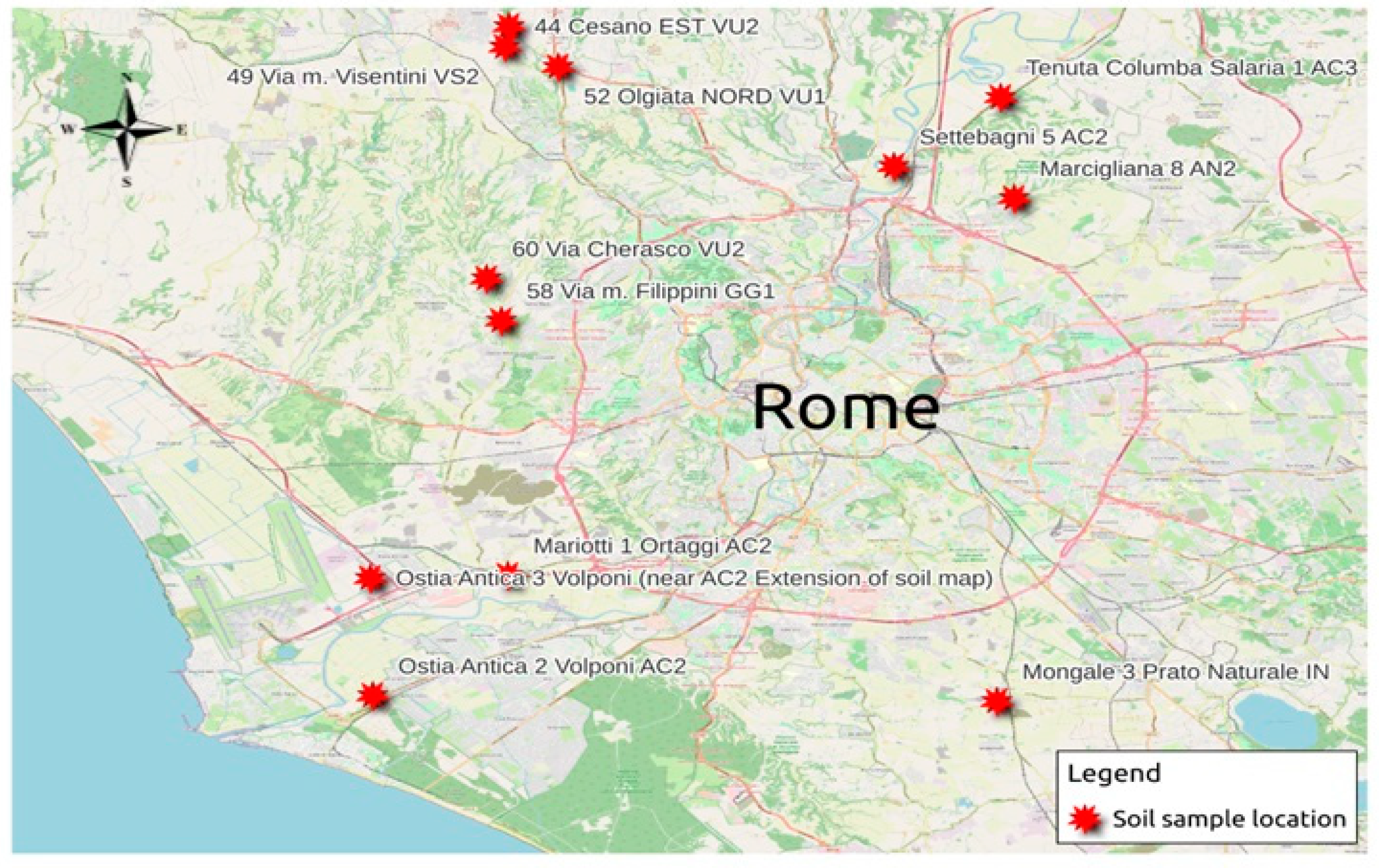
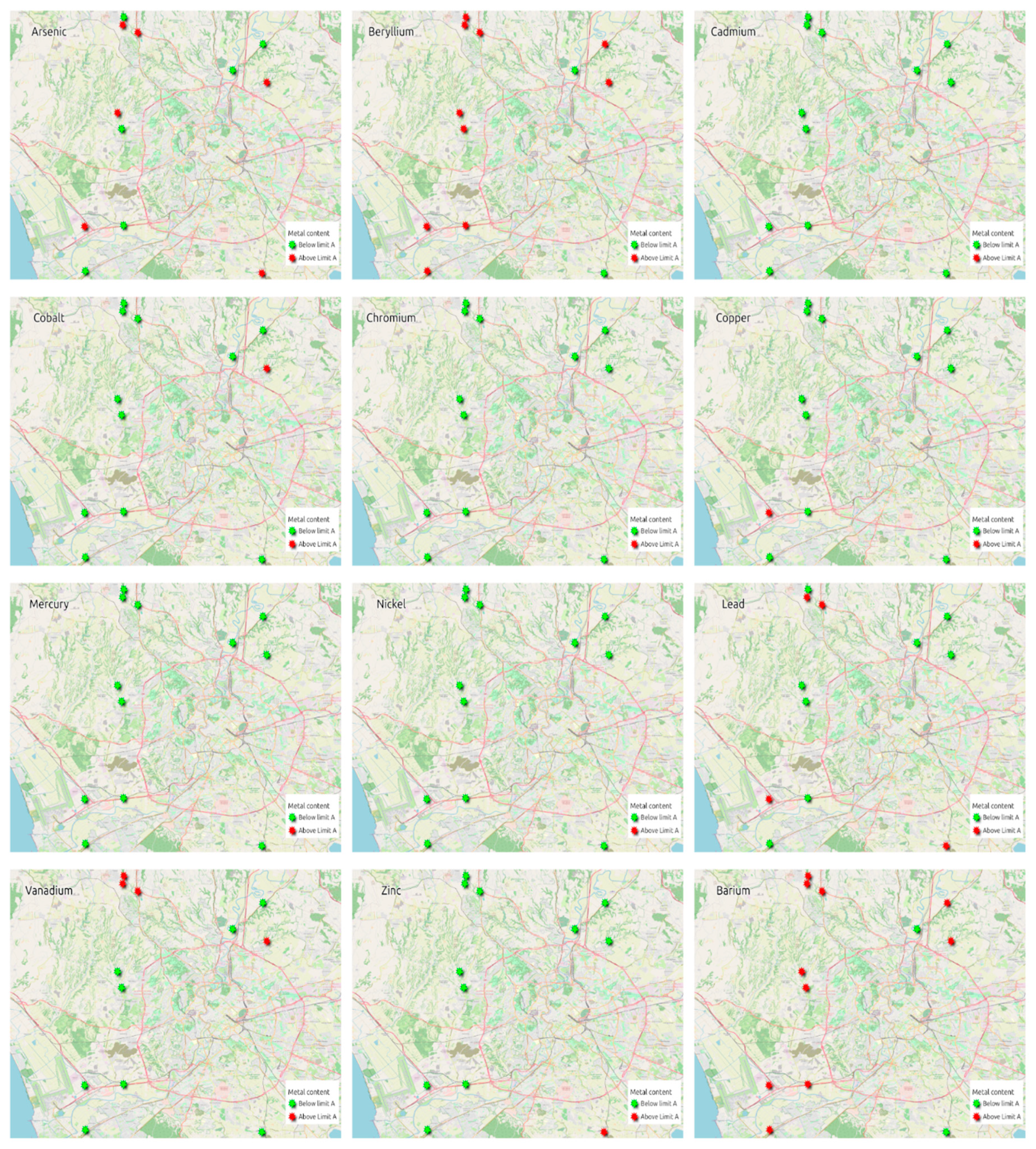
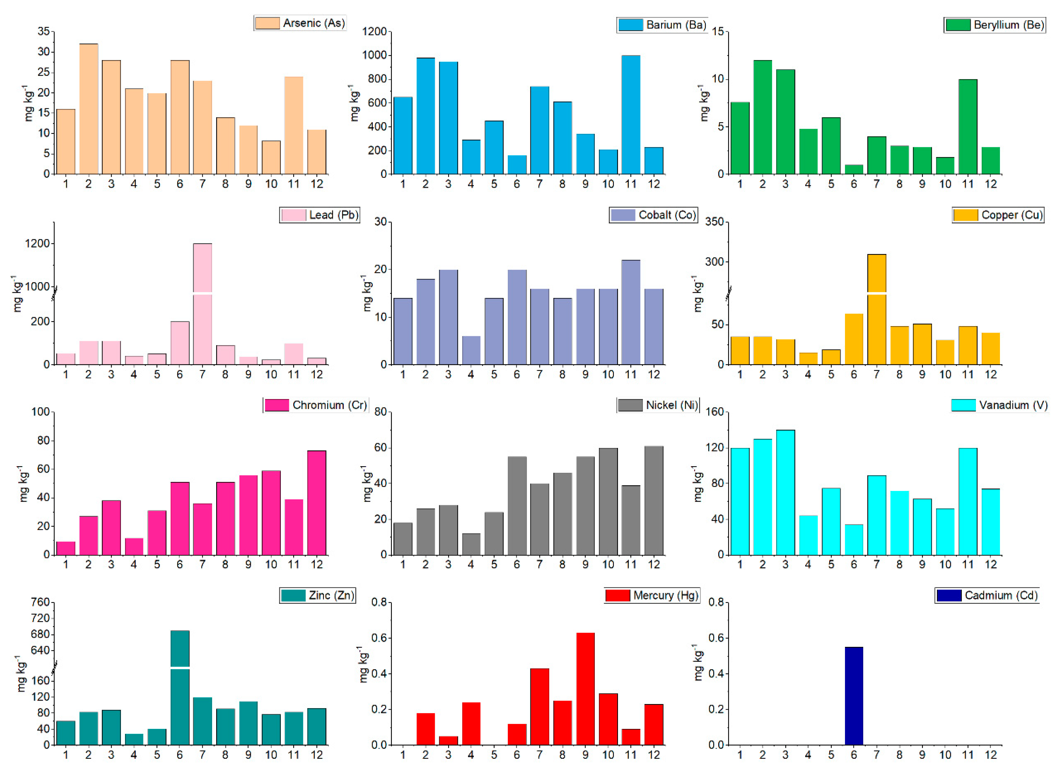
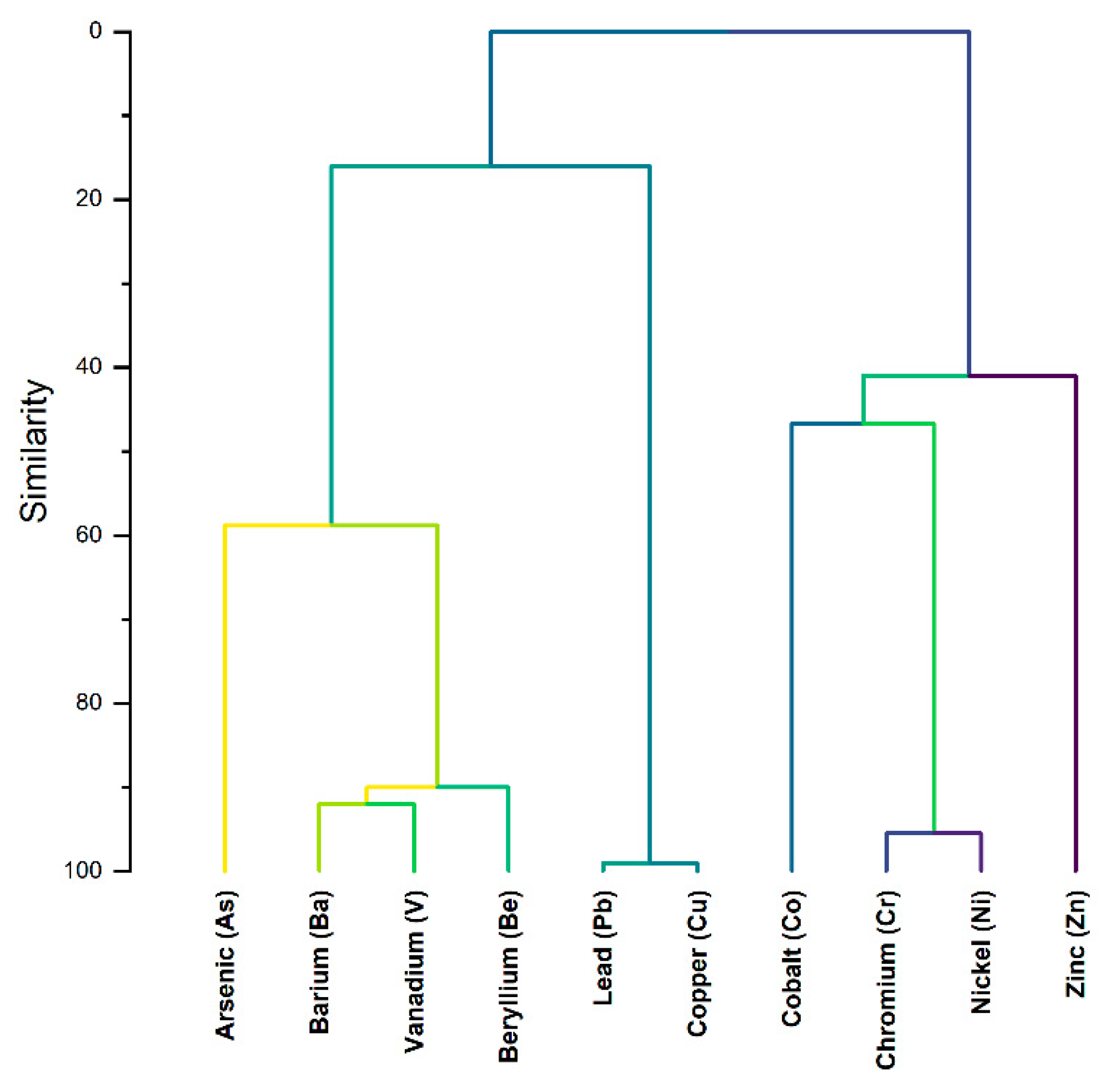
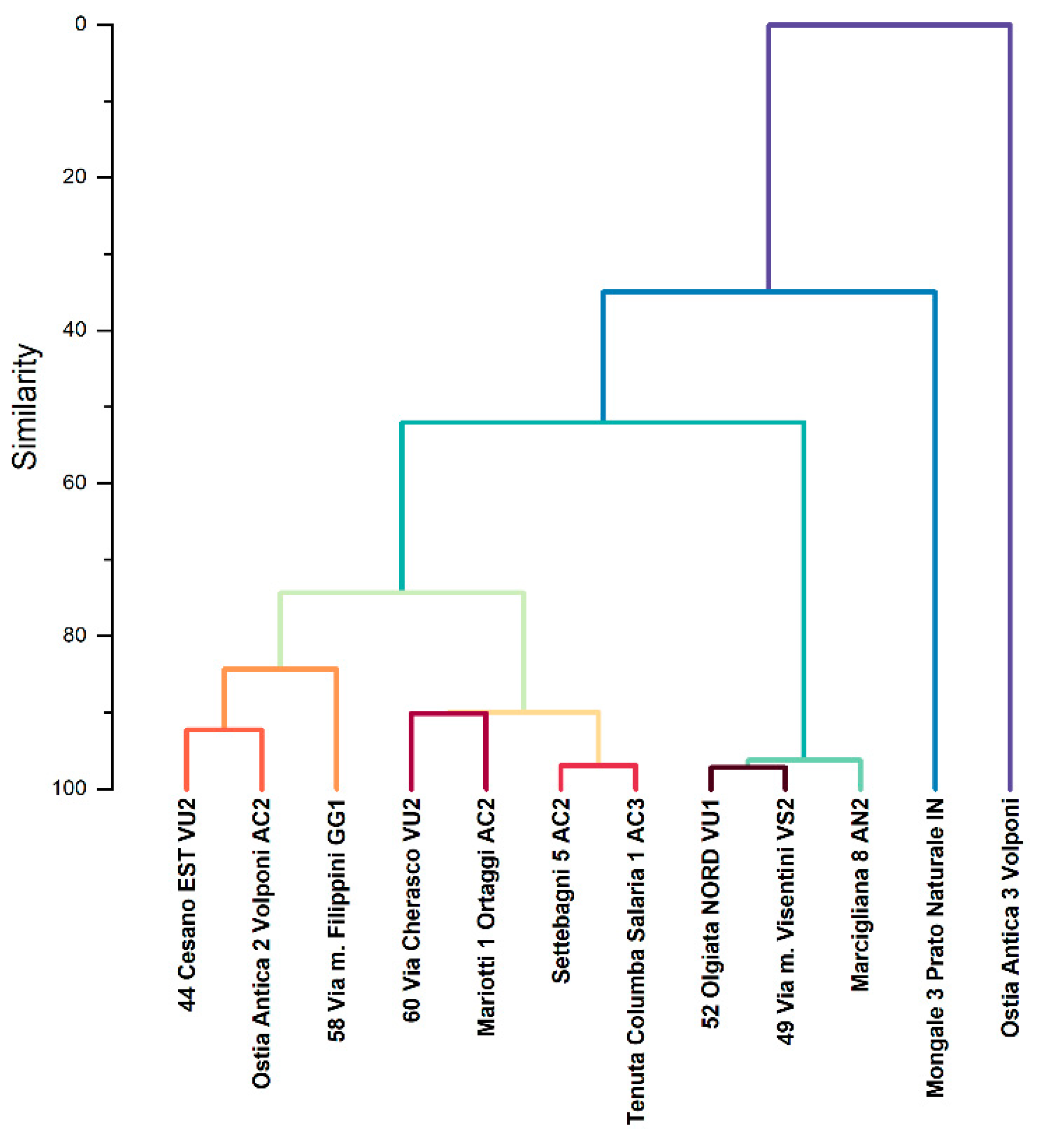
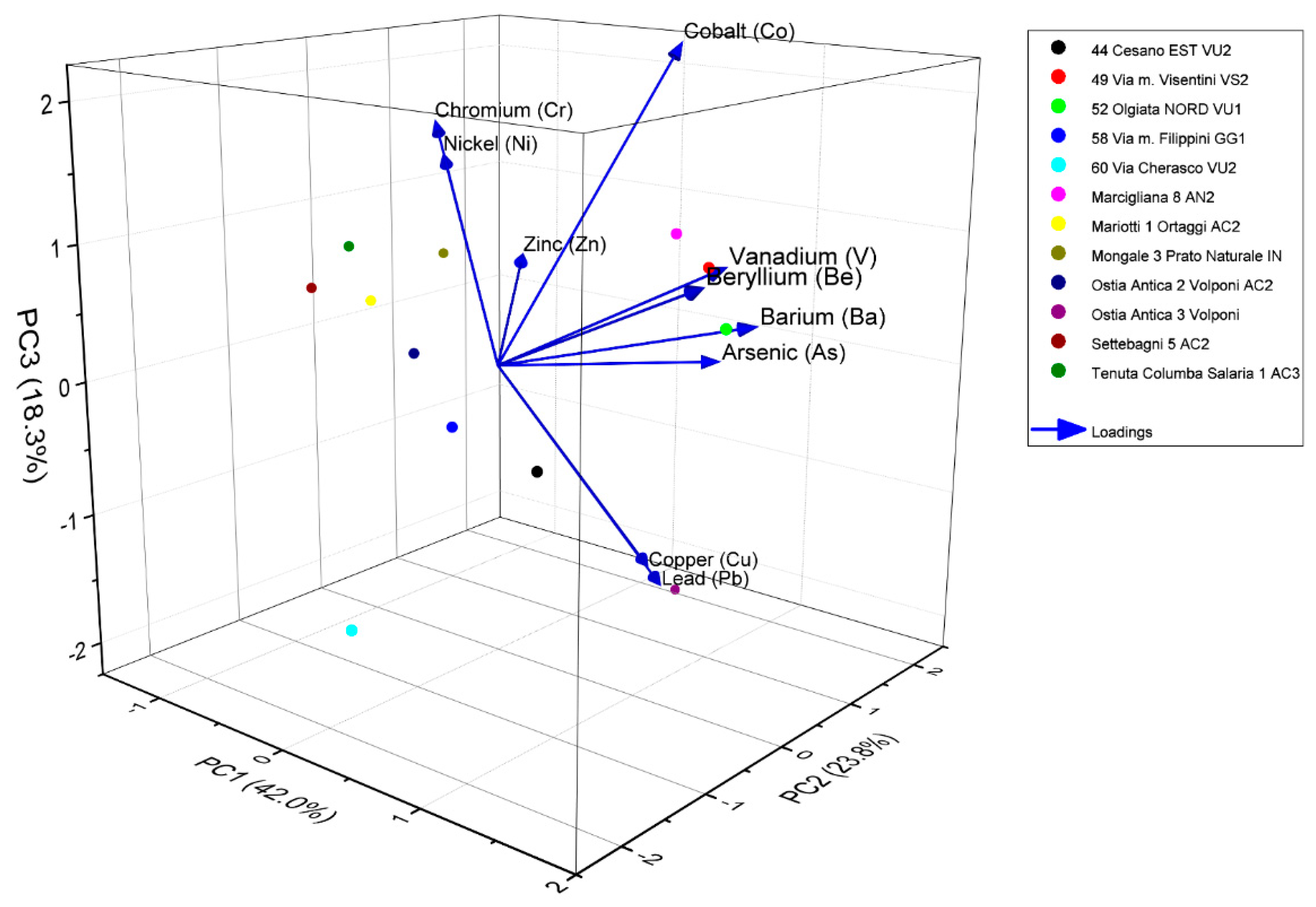
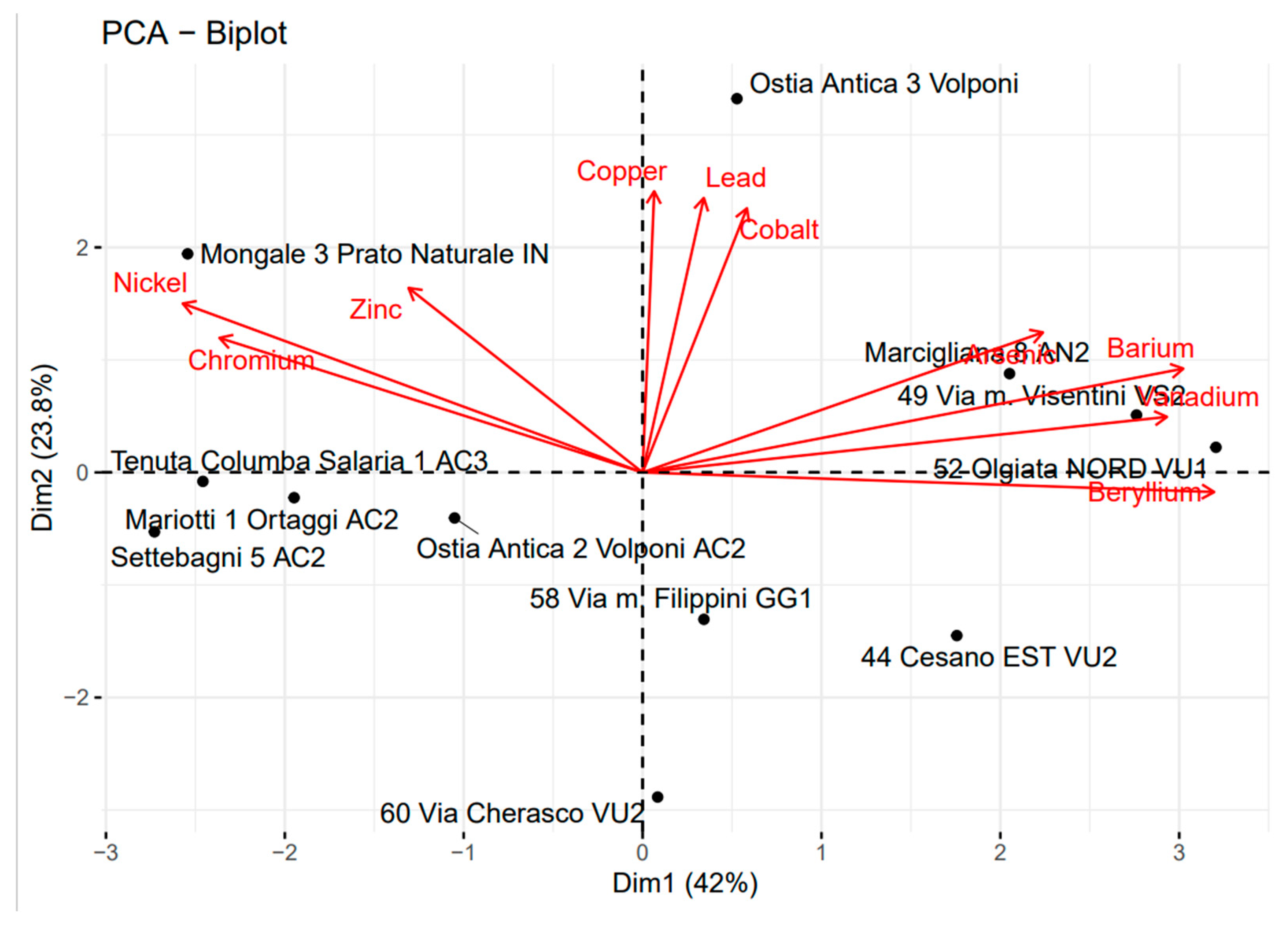
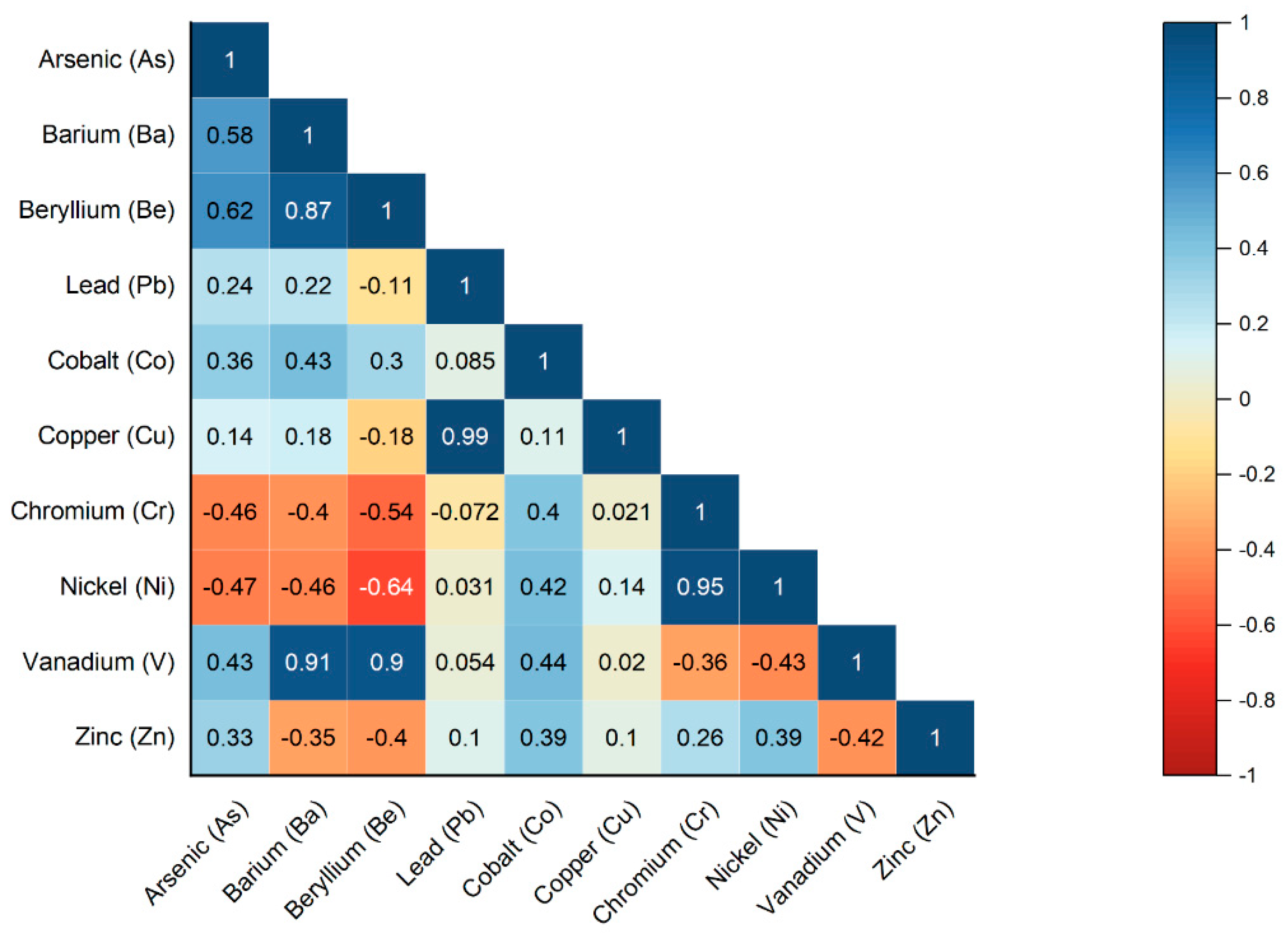
| Sample/Limits | As | Ba1 | Be | Pb | Co | Cu | Cr | Ni | V | Zn | Hg | Cd |
|---|---|---|---|---|---|---|---|---|---|---|---|---|
| 44 Cesano EST VU2 | 16 | 650 | 7.6 | 53 | 14 | 35 | 9.5 | 18 | 120 | 60 | nd2 | nd |
| 52 Olgiata NORD VU1 | 32 | 980 | 12 | 110 | 18 | 35 | 27 | 26 | 130 | 83 | 0.18 | nd |
| 49 Via m. Visentini VS2 | 28 | 950 | 11 | 110 | 20 | 32 | 38 | 28 | 140 | 88 | 0.052 | nd |
| 60 Via Cherasco VU2 | 21 | 290 | 4.8 | 40 | 6.1 | 15 | 12 | 12 | 44 | 29 | 0.24 | nd |
| 58 Via m. Filippini GG1 | 20 | 450 | 6 | 51 | 14 | 19 | 31 | 24 | 75 | 41 | nd | nd |
| Mongale 3 Prato Naturale IN | 28 | 160 | 1 | 200 | 20 | 64 | 51 | 55 | 34 | 690 | 0.12 | 0.55 |
| Ostia Antica 3 Volponi | 23 | 740 | 4 | 1200 | 16 | 310 | 36 | 40 | 89 | 120 | 0.43 | nd |
| Ostia Antica 2 Volponi AC2 | 14 | 610 | 3 | 91 | 14 | 48 | 51 | 46 | 72 | 91 | 0.25 | nd |
| Mariotti 1 Ortaggi AC2 | 12 | 340 | 2.9 | 37 | 16 | 51 | 56 | 55 | 63 | 110 | 0.63 | nd |
| Settebagni 5 AC2 | 8.2 | 210 | 1.8 | 24 | 16 | 31 | 59 | 60 | 52 | 77 | 0.29 | nd |
| Marcigliana 8 AN2 | 24 | 1000 | 10 | 99 | 22 | 48 | 39 | 39 | 120 | 83 | 0.091 | nd |
| Tenuta Columba Salaria 1 AC3 | 11 | 230 | 2.9 | 31 | 16 | 40 | 73 | 61 | 74 | 92 | 0.23 | nd |
| Limit A | 20 | - | 2 | 100 | 20 | 120 | 150 | 120 | 90 | 150 | 1 | 2 |
| Limit B | 50 | - | 10 | 1000 | 250 | 600 | 800 | 500 | 250 | 1500 | 5 | 15 |
| As | Ba | Be | Pb | Co | Cu | Cr | Ni | V | Zn | |
|---|---|---|---|---|---|---|---|---|---|---|
| Mean | 19.77 | 550.83 | 5.58 | 170.50 | 16.01 | 60.67 | 40.21 | 38.67 | 84.42 | 130.33 |
| Minimum | 8.20 | 160.00 | 1.00 | 24.00 | 6.10 | 15.00 | 9.50 | 12.00 | 34.00 | 29.00 |
| Q1 | 13.50 | 275.00 | 2.90 | 39.25 | 14.00 | 31.75 | 30.00 | 25.50 | 60.25 | 72.75 |
| Median | 20.50 | 530.00 | 4.40 | 72.00 | 16.00 | 37.50 | 38.50 | 39.50 | 74.50 | 85.50 |
| Q3 | 25.00 | 792.50 | 8.20 | 110.00 | 18.50 | 48.75 | 52.25 | 55.00 | 120.00 | 96.50 |
| Maximum | 32.00 | 1000.0 | 12.00 | 1200.0 | 22.00 | 310.00 | 73.00 | 61.00 | 140.00 | 690.00 |
| Skewness | 0.03 | 0.25 | 0.56 | 2.90 | -0.91 | 2.86 | -0.09 | -0.08 | 0.25 | 2.90 |
| Kurtosis | 1.82 | 1.57 | 1.91 | 9.64 | 4.17 | 9.53 | 2.27 | 1.64 | 1.75 | 9.68 |
| K-Sp | 1.00 | 0.85 | 0.87 | 0.04 | 0.56 | 0.04 | 0.98 | 0.90 | 0.79 | 0.02 |
| CV [%] | 38.39 | 57.12 | 66.97 | 192.37 | 25.41 | 131.36 | 47.03 | 43.91 | 41.89 | 136.68 |
| Cluster* | As | Ba | Be | Pb | Co | Cu | Cr | Ni | V | Zn |
|---|---|---|---|---|---|---|---|---|---|---|
| I | 17(3) | 570(106) | 6(2) | 65(23) | 14(0) | 34(15) | 31(21) | 29(15) | 89(27) | 64(25) |
| II | 13(6) | 268(59) | 3(1) | 33(7) | 14(5) | 34(15) | 50(26) | 47(23) | 58(13) | 77(35) |
| III | 28(4) | 977(25) | 11(1) | 106(6) | 20(2) | 38(9) | 35(7) | 31(7) | 130(10) | 85(3) |
| IV | 28 | 160 | 1 | 200 | 20 | 64 | 51 | 55 | 34 | 690 |
| V | 23 | 740 | 4 | 1200 | 16 | 310 | 36 | 40 | 89 | 120 |
Disclaimer/Publisher’s Note: The statements, opinions and data contained in all publications are solely those of the individual author(s) and contributor(s) and not of MDPI and/or the editor(s). MDPI and/or the editor(s) disclaim responsibility for any injury to people or property resulting from any ideas, methods, instructions or products referred to in the content. |
© 2024 by the authors. Licensee MDPI, Basel, Switzerland. This article is an open access article distributed under the terms and conditions of the Creative Commons Attribution (CC BY) license (http://creativecommons.org/licenses/by/4.0/).


