1. Introduction
From the beginning of human life, humans sought shelters along bodies of water for life and prosperity. Where water has also played an essential role in the naissance and the development of society. Well-known civilizations such as Egyptians and Indians have settled along the biggest rivers (Nile and Ganges). A river can make a city, creating an image that will be remembered and induce a feeling of tranquillity. Nature and green spaces have been well documented for the potential to improve people’s health and well-being (Ulrich, 1993). The characteristics of green and blue spaces, including their quality, quantity, and proximity, are crucial for promoting health and well-being. Blue spaces have been found to be highly preferred natural settings compared to other urban nature types and there is growing awareness that aquatic or ‘blue spaces’ such as rivers, lakes or the seaside may offer alternative, complementary locations for these relationships.
A river is a “green spine” of a city, which has an irreplaceable role in providing several functions such as: environmental (ecological), social, and economic value. Architects and disaster risk managers of current landscaping meet the principles of equilibrium between flood protection and close to nature landscaping of watercourses. As the famous quote by the Canadian writer Roderick Haig-Brown stated:
“A river is water is its loveliest form, rivers have life and sound and movement and infinity of variation, rivers are veins of the earth through which the lifeblood returns to the heart.” Roderick Haig-Brown, 2011
Roderick Haig-Brown's quote elevates rivers beyond simple waterways, describing them as vibrant, living entities with life, sound, and endless variation. They become "veins of the Earth," carrying not just water but the lifeblood of our planet. While the quote speaks universally, it holds particular resonance for cities like Beirut, where Nahr Beirut once thrived. Rivers like these have provided sustenance, shaped communities, and offered a connection to nature for centuries. Recognizing their vital role, both ecologically and culturally, is crucial for preserving their beauty and ensuring they continue to be lifelines for the cities they flow through.
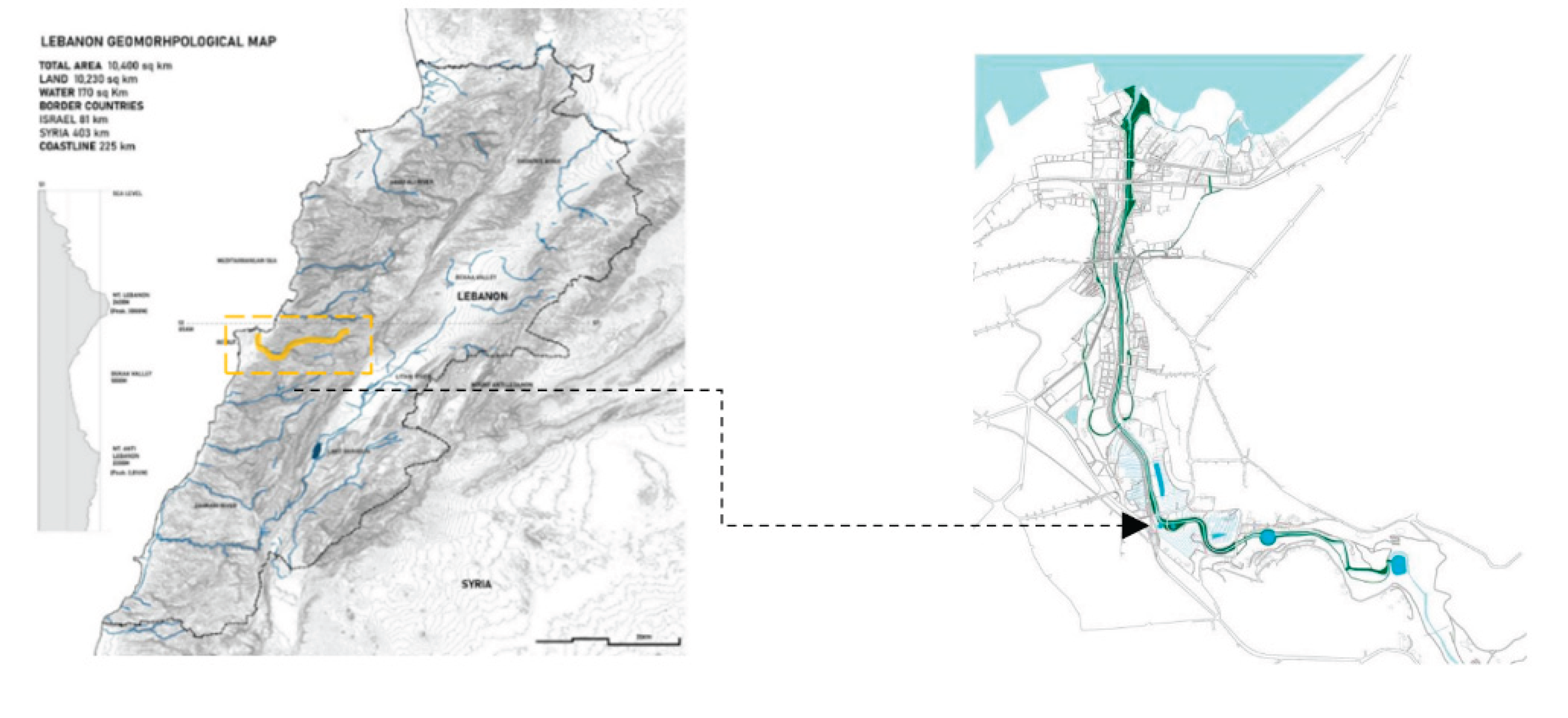
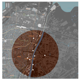
Figure 1.
Map demonstrating Beirut River location within the city. Source: CADScanner, 2023.
Figure 1.
Map demonstrating Beirut River location within the city. Source: CADScanner, 2023.
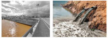
Unfortunately, for undeveloped and developing cities like Beirut, the rivers are completely neglected and highly polluted, and what was once seen as an oasis, has become a nightmare for citizens. This unfortunate event is caused by several aspects which include the negligence of the people, the ongoing economic crises of Lebanon, refugee camps, the deterioration of public spaces, and political issues. As shown in
Figure 2, the accumulation of the before-mentioned issues caused the river to become completely separated from its surrounding, and what was once supposed to be am area for prosperity has become completely neglected. Nahr Beirut also suffers from insufficient waste measures, illegal sewage and industrial runoff over the river, lack of open public spaces and green area, urban heat island effect (especially in surrounding areas such as Burj Hammoud and Quarantina, urban encroachment on the river, and water pollution which causes health risks (Shaban, 2021).
Figure 2.
Image showcasing lack of accessibility and pollution thrown in the river.
Figure 2.
Image showcasing lack of accessibility and pollution thrown in the river.
Due to Beirut’s current economic status, and political dilemma, as previously mentioned, the need for quick, effective, and low-cost solutions have risen. Therefore, in order to ‘cure’ this negligence of the river, the method of pin-pointing specific urban hotspots that would be crucial to impact the entire urban area surrounding the river is applied. Therefore, the main aim of this research paper is to use the ‘blue urban acupuncture’ method, where a series of small-scale interventions can be implemented in certain spots to enhance the economic, social, and environmental aspects within the impacted city. The blue urban acupuncture method involves creating a series of overlapping layers to find out the crucial points where the ‘needling’ can occur. These changes are expected to be implemented efficiently throughout the river spine to inevitably create a domino effect and enhance the surrounding context as a whole. The research hypothesizes ‘blue urban acupuncture’ can be used in several points along the rivers to regenerate them as a source of liveliness and creating a focal point for the users.
2. Literature Review- Blue Urban Acupuncture: Stitching Together City and Water
Acupuncture, a traditional Chinese medical practice, seeks to restore energy and general well-being through the insertion of very fine needles in strategic points, causing the revitalization and balance of the being. However, what does acupuncture have in common with architecture? Urban acupuncture is an architectural approach to urban regeneration, aiming to regenerate a specific urban area in a way that brings about transformative and revitalizing effects on both the area itself and its surroundings context.
Urban acupuncture relies mainly on two approaches, the first is that interventions in public spaces do not need a large investment or be on a large scale to have a transformative impact. The second is that urban space improvement helps improve the quality of all the connections that converge at that point, such as squares, streets, or parks. Jaime Lerner, the author of the Book of Urban Acupuncture, was the architect and politician who introduced this new concept in his TED talks, where he described urban acupuncture as an urban design strategy, using the theoretical basis of acupuncture which aims to act on strategic points of the human body to revitalize the overall energy of the body (Lerner,Ribeiro,2014).
The concept of "blue urban acupuncture" has emerged as a promising strategy for revitalizing urban environments through strategic interventions focusing on water bodies. This literature review delves into the key themes and nuances surrounding this approach, drawing upon scholarly articles, reports, and project examples.
At its core, blue urban acupuncture emphasizes the transformative potential of small-scale, site-specific water interventions within the urban fabric. Proponents highlight its ability to address a multitude of challenges, including stormwater management, ecological restoration, public space creation, and community engagement. Studies by authors like Benedict and McMahon (2002) and Fletcher et al. (2014) emphasize the effectiveness of blue infrastructure in mitigating flood risks and improving water quality, while highlighting the co-benefits of increased aesthetics and recreational opportunities. Furthermore, works by Loder et al. (2017) and Meerow and Lehmann (2016) explore the social dimensions of blue acupuncture, showcasing its potential to foster community well-being and enhance connections to nature within urban contexts.
However, the literature also acknowledges the complexities and challenges associated with implementing blue urban acupuncture. Moschella et al. (2020) caution against a one-size-fits-all approach, emphasizing the need for context-specific designs that consider social, cultural, and ecological factors. Additionally, ensuring community participation and navigating complex governance structures are highlighted as crucial aspects for successful implementation, as discussed by Fletcher et al. (2020) and Brandligt et al. (2021).
In conclusion, the literature review paints a promising picture for blue urban acupuncture as a multifaceted strategy for revitalizing cities. While challenges exist, the potential for ecological, social, and aesthetic benefits underscores the need for further research and implementation efforts. As cities around the world deal with growing populations and environmental pressures, blue urban acupuncture offers a valuable tool for stitching together the urban fabric with the lifeblood of water, fostering healthier and more sustainable communities.
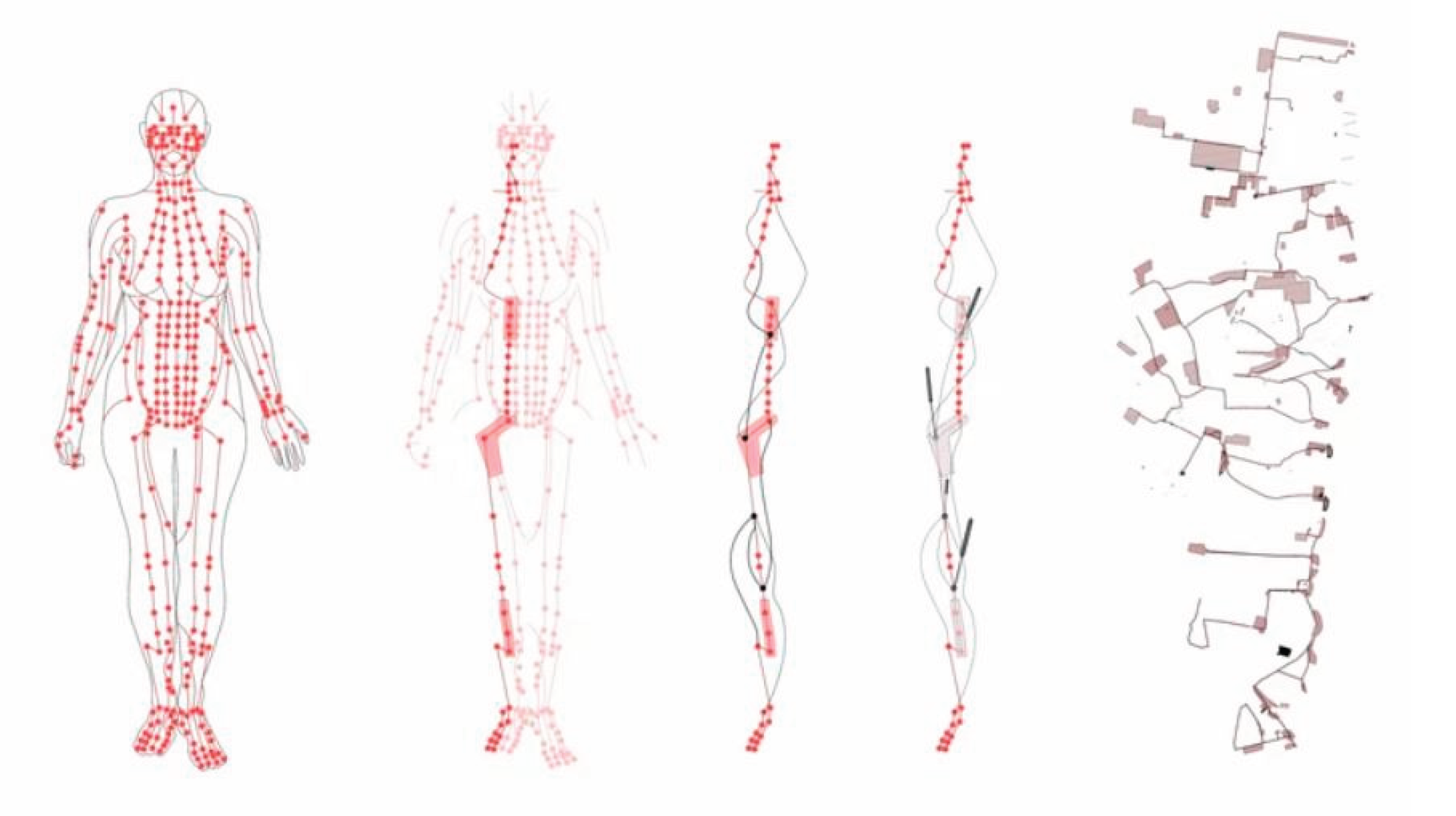
Figure 3.
Figure showcasing the definition of acupuncture in the urban context. Source: Raumlabor, 2021.
Figure 3.
Figure showcasing the definition of acupuncture in the urban context. Source: Raumlabor, 2021.
There are three approaches in which blue urban acupuncture can be applied within any given site which are (The World Bank Data, 2022):
Revitalizing neglected coastal areas: which mainly focuses on transforming an underused urban river, waterfront, etc. into a vibrant community hub. Which shows increased physical activity, social interaction, and well-being among residents.
Creating new blue spaces within cities: such as adding rainwater gardens or pocket parks with water features within the city. Which demonstrate how even limited space can be used for blue acupuncture.
Enhancing existing waterways: such as transforming neglected canals and riverwalks into vibrant public spaces and revitalizing these spaces. Which demonstrates the potential of blue spaces to improve connectivity and walkability.
Figure 4.
Figure showcasing the needling in the city.
Figure 4.
Figure showcasing the needling in the city.
3. Analysing Similar Examples for Neglected Rivers
Across the globe, cities are embracing blue urban acupuncture interventions to revitalize their communities and enhance their liveability. These interventions, which incorporate water elements and natural design principles, aim to transform underutilized or degraded spaces into vibrant and sustainable hubs, fostering ecological benefits, social interaction, and economic development. However, in order to create a clear analysis for urban acupuncture and its approach for enhancing the neglected public spaces, there needs to be a clear comparison between two examples that have been restored using different approaches which will be stated in a comparison table.
3.1. Cheonggyecheon Stream in Seoul - Sustainable Urban Development
3.1.1. Criteria of Selection
There are several reasons for choosing the Cheonggyecheon Stream in Seoul, since it serves not only as an example for comparison between conventional and urban acupuncture approaches, but also showcases the endless possibilities of how urban acupuncture can be integrated within the long-term permanent development of a certain site. Cheonggyecheon Stream represents a significant example of conventional urban redevelopment practices, where the restoration project also incorporated several elements of urban acupuncture. Moreover, the restoration project aimed to revitalize the stream and its surroundings by reintroducing natural elements, improving pedestrian access, and creating spaces for community engagement and cultural activities.
3.1.2. The Sustainable Urban Revitalization
Once a natural stream flowing through Seoul, South Korea, the Cheonggyecheon was later transformed into a concrete-covered highway due to rapid development following the Korean War. However, in 2003, an ambitious urban renewal project was undertaken to restore the stream to its former glory, demolishing the highway and revitalizing the waterway. Despite initial scepticism, the project has been met with resounding success, becoming a beloved public space for both locals and visitors. Since the 1960s, development, construction, production, and efficiency have always been priorities in Seoul. Starting from 1990s, however, the urban planning paradigm shifted to focus more on human, history, nature and environment, as the people's consciousness changed over the course of socio-economic development. Discussions on justification, necessity, and significance of restoring Cheonggyechon became lively since the late 1990s. Over the course of political debate, the direction of the initial plan shifted from reconstruction of the elevated highway to restoration of the stream. An ambitious urban renewal project was undertaken to restore the stream to its former glory, demolishing the highway and revitalizing the waterway (Hobton, 2011). The restoration included the removal of the bridge as the most primary step for the restoration and the implementation of bridges which would increase the accessibility of the pedestrian and provide alternative modes of transportation along the river.
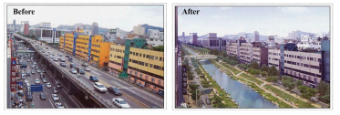
Figure 5.
Image showcasing before and after for Cheonggyecheon Stream in Seoul. Source: Kauishe, 2021.
Figure 5.
Image showcasing before and after for Cheonggyecheon Stream in Seoul. Source: Kauishe, 2021.
The restoration project extended almost 6km. The essence of the restoration program was “space creation” – a place where the city’s residents could enjoy the ‘liveliness of a friendly Seoul.’ Defined concepts of history (tradition), culture (modernity), and nature (future) were introduced to confer diversity onto the respective sections of restored areas.
The restoration of Cheonggyecheon Stream in Seoul exemplifies a shift from conventional to sustainable urban development strategies. Initially, the stream was covered with concrete, reflecting a conventional approach that prioritized infrastructure over environmental concerns. However, the restoration project adopted sustainable strategies by uncovering the stream, naturalizing its banks, and introducing green spaces. These interventions improved water quality, restored biodiversity, and created a more aesthetically pleasing and ecologically balanced urban environment.
In addition to these sustainable strategies, the restoration project also incorporated urban acupuncture principles to further enhance the revitalization. This included the integration of pedestrian-friendly infrastructure, such as walking paths and bridges, to improve accessibility and encourage social interaction. Cultural elements, such as art installations and historical markers, were also added to enhance the area's cultural identity and attract visitors. These urban acupuncture interventions aimed to create focal points of activity and interest along the stream, promoting a sense of community engagement and ownership. Together, these combined strategies transformed Cheonggyecheon Stream into a sustainable, vibrant, and socially inclusive urban space.
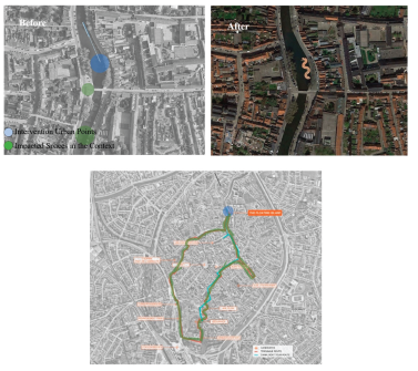
Figure 6.
The Cheonggyecheon Stream before and after the development, with the access points to the city. Source: Jekaterina Balicka, Anna Wilczyn’ska.
Figure 6.
The Cheonggyecheon Stream before and after the development, with the access points to the city. Source: Jekaterina Balicka, Anna Wilczyn’ska.
3.1.2. Sustainable Restoration Meets Urban Acupuncture Integration
In 2003 a river restoration project was launched to bring environmental benefits back to the river. The overall aims were for:
An ecologically sensitive pedestrian corridor which improves the environment
To dismantle the elevated freeway and concrete deck above the stream
Improve the quality of life of people in Seoul
To remove the safety risks posed by the decaying freeway built over the top of the river
To increase business competitiveness and connectivity either side of the river (North and South)
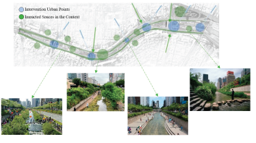
Figure 5.
The Urban Acupunctural Strategies in Cheonggyecheon Stream in Seoul. Source: Author.
Figure 5.
The Urban Acupunctural Strategies in Cheonggyecheon Stream in Seoul. Source: Author.
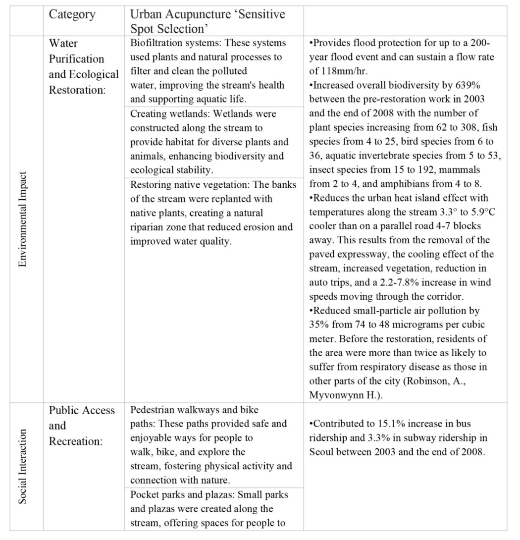
Table 1.
Urban Acupuncture Implementation within the Cheonggyecheon Stream in Seoul.
Table 1.
Urban Acupuncture Implementation within the Cheonggyecheon Stream in Seoul.
The selection of urban acupuncture points in the restoration of Cheonggyecheon Stream in Seoul was guided by a strategic assessment of the urban landscape. Specific criteria included the potential for interventions to enhance environmental sustainability, preserve cultural heritage, improve pedestrian connectivity, and contribute to the aesthetic enhancement of the area. This methodical approach ensured that the chosen points aligned with the project's overarching goals of creating a more sustainable, vibrant, and socially inclusive urban environment.
As shown in
Figure 5 above, The Cheonggyecheon Stream in Seoul wasn't just a conventional river restoration project; it was a strategic urban acupuncture intervention as well that revitalized a neglected area and sparked positive change across social, environmental, and economic spheres. By transforming a concrete-encased highway into a vibrant public space, it didn't merely revive the waterway but created potent "sensitive urban points" along its banks. Community art installations and educational workshops blossomed, fostering cultural vibrancy and environmental awareness. Open-air performances and pop-up markets pulsed with economic activity, attracting residents and tourists alike. Bike rentals and floating libraries encouraged eco-friendly exploration and intellectual engagement. Instead of a singular, large-scale development, the Cheonggyecheon Stream became a canvas for multiple, targeted interventions, each injecting vitality and purpose into the surrounding urban fabric. This is the true strength of urban acupuncture - not just beautification, but the strategic activation of neglected spaces to trigger a ripple effect of positive change, weaving social, environmental, and economic benefits into the very heart of the city. (Apostolou, 2015). These interventions are parallel to "acupuncture points" that aim to improve the overall health and vitality of the urban fabric. Therefore, the project can be viewed through the lens of urban acupuncture as it demonstrates how small-scale interventions can have a significant impact on the larger urban environment.
3.2. Kastrup Sea Bath, Copenhagen, Denmark- Urban Acupuncture Interventions-
3.2.1. Criteria of Selection
Kastrup Sea Bath in Copenhagen, Denmark, is an exemplary case of urban acupuncture due to its successful transformation of an industrial area into a vibrant recreational space. The project's emphasis on community engagement, integration with nature, and promotion of public health aligns with the principles of urban acupuncture. Furthermore, the sea bath has served as a catalyst for broader urban development, showcasing the potential of small-scale interventions to positively impact the urban landscape.
3.2.2. Urban Acupuncture Method for Revitalizing Neglected Coastal Areas
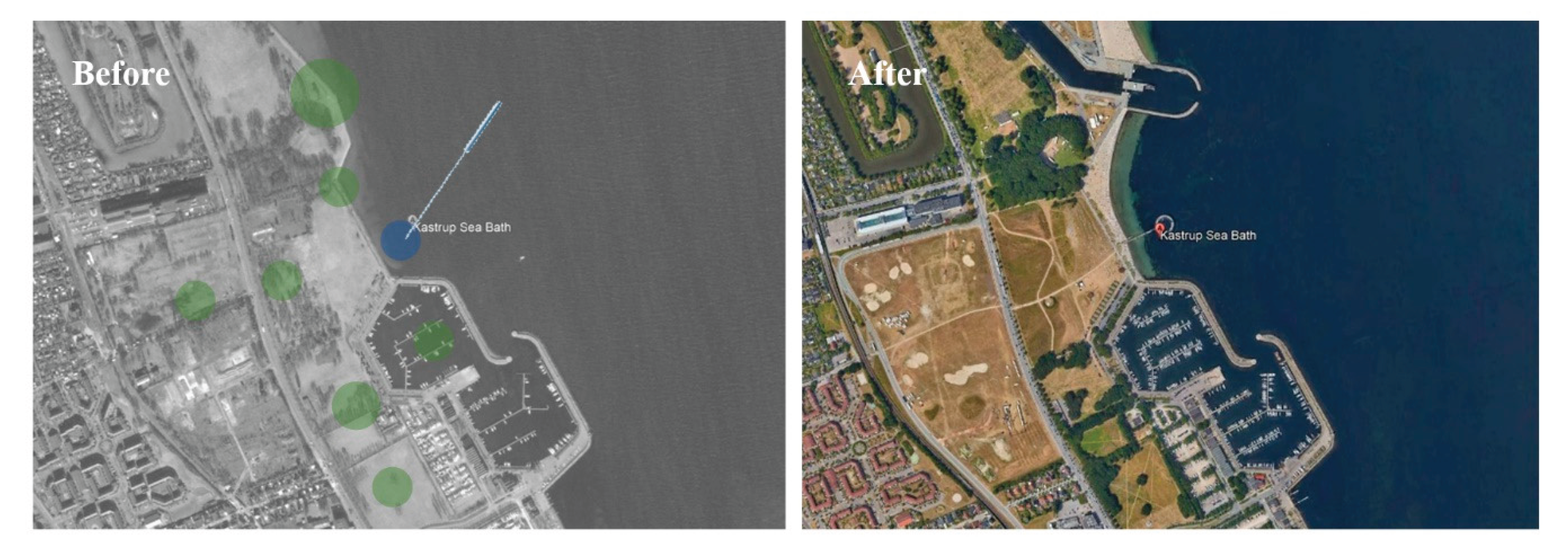
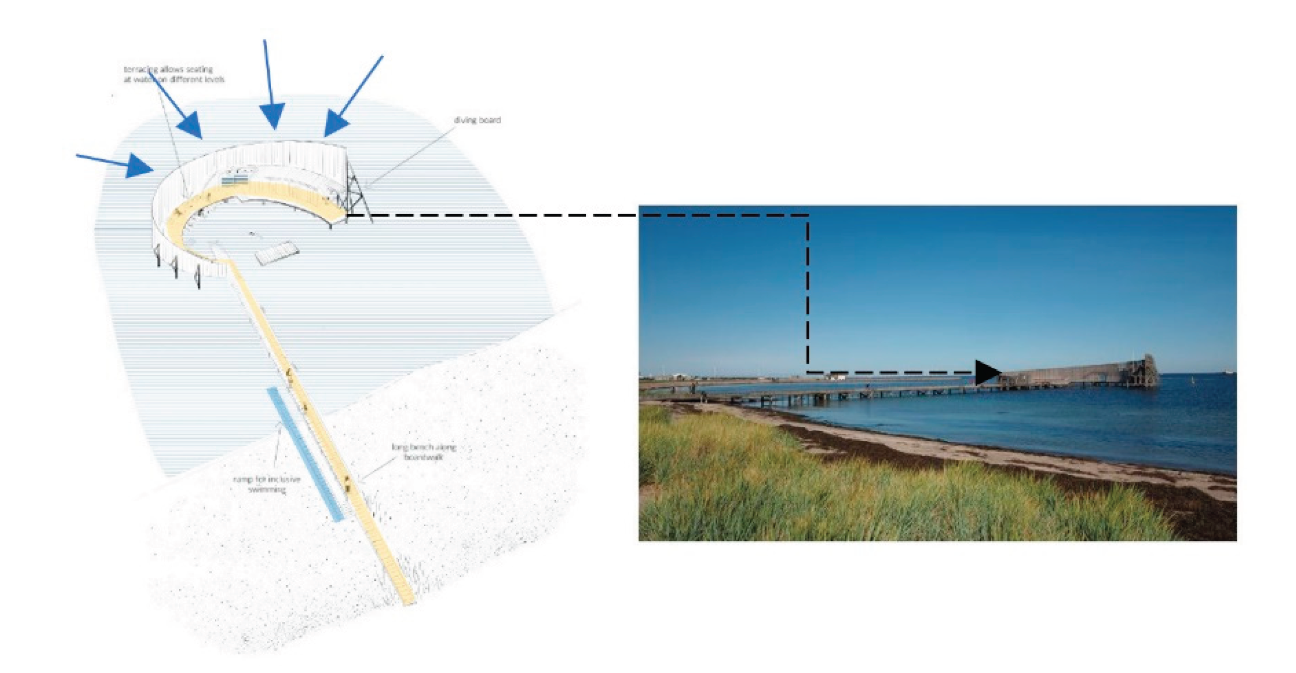
This structure, which provides sheltered access to the sea at Kastrup Beach, Copenhagen, was completed in 2005 from the designs of White Arketekter of Sweden. It has become affectionately known as ‘The Snail’ and consists of a circular raised enclosed platform and a pier leading out to it, a new beach and a service building containing toilets and accessible changing facilities set into the circular structure. All functions provided are therefore incorporated into the one structure. The idea of the form was a response to the exposed north-facing beach where shelter is needed; the wooden pier meets the bathing structure and continues into the south-facing circular enclosure, gradually rising above sea level and ending in a 5-m-high diving platform. The circular shape creates a focused interior that provides shelter from the wind and the perfect protected retreat for swimming and sunbathing. A continuous bench runs along the inner pier wall, providing lots of seating for resting and relaxation. It was designed to be fully accessible and inclusive, open at all times (it is illuminated at night and free of charge). It is constructed of an extremely durable African hardwood called azobé. For disabled users, it is possible to make use of special wheelchairs to go into the water for a swim. The site was a former brownfield and lies close to the Amager Beach park. The main approach to the design of this intervention was to “bring the land into the sea”, and the intervention does this by providing access to deeper water away from shallow beaches. It therefore enables many ways to enjoy water in a controlled and overlooked site and at the same time creating an environment fully surrounded by the sea (Vassiljev et al., 2020).
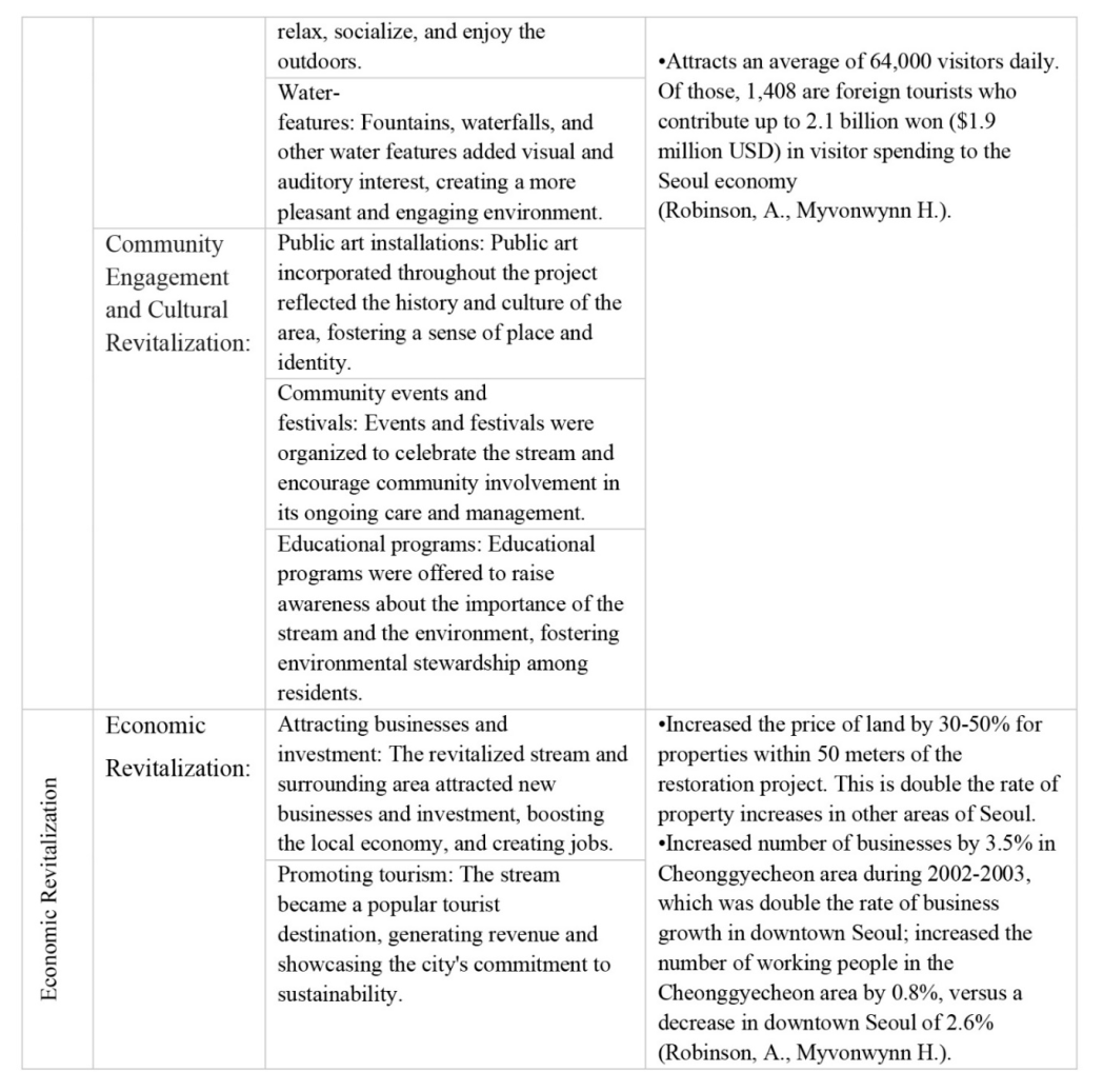
The table below showcases the urban acupuncture interventions that were applied to specific key points in order to revitalize the neglected coastal area:
Table 2.
Urban Acupuncture Interventions within the Kastrup Sea Bath, Copenhagen, Denmark.
Table 2.
Urban Acupuncture Interventions within the Kastrup Sea Bath, Copenhagen, Denmark.
As shown in
Figure 6, when an urban acupuncture point is strategically placed and hits the correct spot, it can have a significant impact on several components around it simultaneously. First, it serves as a catalyst for change, initiating a positive transformation in its immediate surroundings. In this example, the structure placed on the sea encouraged people and tourists to engage in the experience of a floating structure. This eventually led to the creation of several open spaces around the area where people can enjoy their day, moreover, vegetation has seen an apparent increase throughout the years due to their need in the open spaces. Second, an increase number of pathways, which enhanced pedestrian’s accessibility, were created for an easier approach from the nearby roads to the beach where the structure is placed on. Third, an extended platform on the peripheries of the sand beach was created to increase the capacity of people and allow a homogenous approach from the beach to another pathway structure which connects land to sea. Nevertheless, inclusivity was an important aspect that was taken into consideration, where a special ramp was constructed for the physically challenged people who required a wheelchair, which led to experiencing swimming independently.
Figure 6.
The Urban Acupunctural Strategies before and after in Kastrup Sea Bath, Copenhagen, Denmark. Source: Author.
Figure 6.
The Urban Acupunctural Strategies before and after in Kastrup Sea Bath, Copenhagen, Denmark. Source: Author.
Figure 7.
The snail like shape extended to create a connection between the land and water. Source: Anna Wilczyn’ska.
Figure 7.
The snail like shape extended to create a connection between the land and water. Source: Anna Wilczyn’ska.
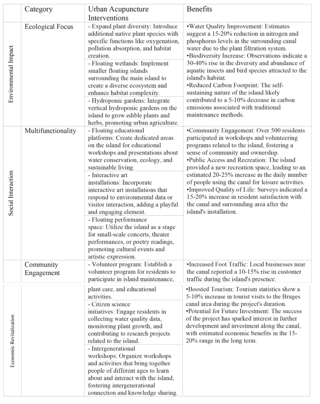
3.3. The Floating Island in Bruges, Belgium- Urban Acupuncture Interventions
3.3.1. Criteria of Selection
This example showcases an example for urban acupuncture where it reflects its alignment with fundamental principles in this design approach. This innovative project showcases adaptive reuse of urban space, repurposing a canal into a dynamic green area. Such repurposing echoes the core philosophy of urban acupuncture, which seeks to revitalize urban settings through localized and targeted interventions. Moreover, the Floating Island provides a public space for residents and visitors.
3.3.2. Urban Acupuncture Method for Enhancing Existing Waterways
Once a bustling artery for Bruges' industry, the Groenerei Canal had fallen into a slumber. Years of neglect draped the waterway in a shroud of pollution, its stagnant waters mirroring the fading memory of its former vibrancy. Overgrown banks and crumbling quays whispered tales of forgotten commerce, while the absence of public access cemented its isolation from the city's vibrant pulse. The Groenerei, once a lifeblood, had become a forgotten scar, a silent testament to the shifting priorities of the city that had once relied on its strength. This neglect, a consequence of industrial decline and changing needs, paved the way for a future intervention, a chance to reawaken the canal and reclaim its rightful place in the tapestry of Bruges. The Floating Island, with its verdant promise and innovative spirit, became a beacon of hope, beckoning the Groenerei back to life. In its wake, not just water filtration and ecological revival, but the rekindling of a connection between city and waterway, a bridge built on the principles of sustainability and community. After years of neglect, the initiative to create an open space as a temporary structure on the peripheries of the canal, sparked the concept of urban acupuncture approach. This space was created as a way to revive and enhance the pedestrian paths along the canal way and reduce the impact of an industrial canal, but rather a space for social cohesion and environmental enhancement (Chamseddine, 2017). Bruges in Belgium, also known as ‘Venice of the North’, is a city designated as a UNESCO World Heritage still showing the beautiful old section of the city in the Middle Age. The canal going through the city, along with the well-preserved structure, is the unique element of Brugge providing beautiful landscapes. OBBA intended to make a small change in these beautiful landscapes. By installing “The Floating Island”, a pavilion in long streamlined shape floating on the water, as an initiative for an urban acupuncture intervention. OBBA tried to blur the rigid boundary of the canal and guide people to the waterside. In this way, by planning the canal as a place where visitors can walk, rest, reflect, and enjoy on the water, not just as a borrowed scenery. The pavilion consists of pontoons on the water, metal frames, deck plates, metal pillars, upper metal rails connecting the pillars, and rope curtains embracing the rails. The rope curtains and their shadows create ambiguous spaces that seem to be opened and closed at the same time. In addition, the curtains and shadows reacting to the lights and winds blur the boundary, repeatedly open and close visitors’ sights, and make familiar landscapes fresh again. In this way, “The Floating Island” gives the time of joy and reflection to the citizens and extends the boundary of their acts and perceptions (Marletto, Sillig, 2019).
Figure 8.
Problems facing The Floating Island in Bruges, Belgium which led to its neglect. Source: Author.
Figure 8.
Problems facing The Floating Island in Bruges, Belgium which led to its neglect. Source: Author.
Figure 9.
Image demonstrating the curvilinear shape of the floating structure. Source: ImageBlocks, 2022.
Figure 9.
Image demonstrating the curvilinear shape of the floating structure. Source: ImageBlocks, 2022.
The site selection for this structure was based on strategic planning based on observing the gateway of the city. Not only does this spot act as the gate to the city, but also, it carries a symbolic significance, reflecting the cultural identity of Bruges and its historical relationship with water. This cultural integration aligns with urban acupuncture's objective of preserving and celebrating local heritage.
The location of the floating island created an immense impact one the surrounding context through several aspects, the most prominent one being the purification of pollution levels within the highly polluted canal. This inevitably led to the increase number of vegetation along the peripheries of the river which led to the creation of open spaces along the sideways and increase of visitors to the site. The island's greenery and natural elements help mitigate the urban heat island effect by providing shade and cooling effects. This contributed to a more comfortable urban environment, especially during hot weather. Furthermore, the island creates a new public space within the urban environment, providing residents and visitors with a unique recreational area. This contributes to the overall liveability of the city by offering opportunities for leisure activities and social interaction.
Table 3.
Urban Acupuncture Interventions within the Floating Island in Bruges, Belgium.
Table 3.
Urban Acupuncture Interventions within the Floating Island in Bruges, Belgium.
As shown in the
Figure 10 above, a canal, once a forgotten scar, is reimagined as a vibrant artery. Floating islands adorned with vegetation cleanse the water, creating a haven for aquatic life and offering tranquil reflections of the cityscape. These seemingly small interventions trigger a domino effect of positive changes. The park became a natural gathering space, fostering social interaction and a renewed sense of community. Local businesses, invigorated by increased foot traffic, expand their offerings, spilling onto sidewalks with vibrant storefronts. The revitalized waterway, once a barrier, becomes a connector, inviting residents to engage with the city's natural fabric (Lara-Hernandez, Melis, 2018).
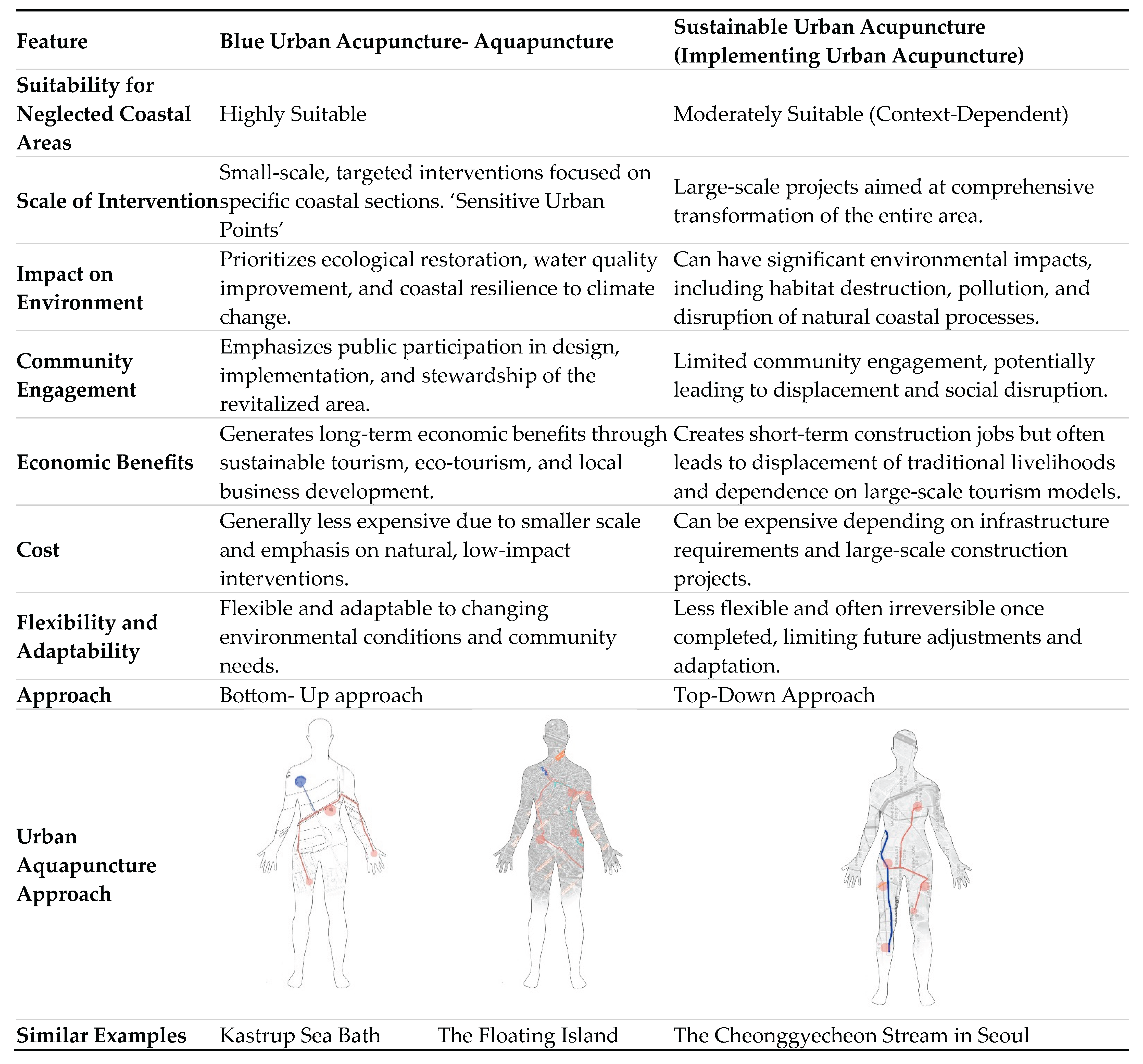
4. Comparative Table- Sustainable Urban Development and Urban Acupuncture Approach
As it is shown in
Table 4, there is a clear difference between the approach of urban acupuncture and conventional approach. Although they are similar in several aspects when it comes to enhancing the context of a given space, however, urban acupuncture targets specific spaces that are highly in need of revitalization in order to create a series of positive outcomes within the city. Nevertheless, given the ongoing economic crises that almost 70% of the world is going through, acupuncture, as a strategy, fulfills the vision of reviving a given area with short time and less expenses.
However, the question remains of, why is blue urban acupuncture more suitable for neglected coastal areas? Below are some statements that were deducted throughout the research which demonstrates the importance of urban acupuncture approach in revitalizing the neglected spaces:
Targeted Interventions: Addresses specific challenges like erosion, pollution, and habitat loss without large-scale disruption to the natural coastal ecosystem.
Sustainable Approach: Focuses on natural restoration and low-impact interventions, ensuring long-term ecological resilience and minimizing resource consumption.
Empowers Communities: Provides opportunities for local residents to participate in the revitalization process, fostering ownership and responsibility for the coastal area.
Economic Diversification: Promotes sustainable economic development through eco-tourism, local fisheries, and small businesses, enhancing livelihood opportunities for local communities.
Cost-Effective: Requires less upfront investment compared to large-scale projects, making it accessible for smaller communities and budgets.
Adaptable and Scalable: Allows for phased development and adjustments based on evolving needs and changing environmental conditions.
While sustainable urban development might be suitable for specific large-scale coastal projects, it often comes with significant environmental and social drawbacks, and its economic benefits may not be evenly distributed within the community, and would most of the time need the intervention of small-scale projects to enhance the surrounding context and become a focal point within the city (Shaban, 2021).
5. Methodology
It is apparent between all the similar examples analysed that urban acupuncture method is used to facilitate the urban regeneration of a specific neglected space. This is achieved through pin-pointing specific spots that would further enhance the change to the larger scale around the given area. Moreover, the key catalyst for this sustainable urban regeneration occurs through the triple bottom line which are environmental, social, and economic impacts.
The research paper utilizes several types of research methodology which can be summarized as three types: First, through comprehensive data collection encompassing the Beirut River's historical trajectory, researchers utilize the inductive method to identify its changing phenomena in the urban context. Second, using the analytical method for analysing the three similar examples to create a common framework that can be used to assess the case study. Third, using spatial network analysis which utilizes the space syntax method- using the DepthmapX software- to analyse and visualize the visibility, accessibility, connectivity, and permeability. This method will create a network of overlapping layers which will be used as layers to create points of urban acupuncture interventions for efficient regeneration of the area. Finally, the deductive method which is used to create a series of potential ideal “sensitive urban spots” that would be used to regenerate the neglected rivers through blue urban acupuncture integration. The three research methodologies are demonstrated below.
6. Introducing the Case Study of ‘Regenerating Nahr Beirut’ in Lebanon
After the thorough analysis of three similar examples showcasing how the impact of urban acupuncture interventions can be efficient in transforming the city’s context. However, the decision to take upon this approach requires keen analysis and research, since urban acupuncture mainly focuses on the ‘sensitive spots’ within a given context. Unfortunately, Beirut faces lack of public spaces, and empty lots remain neglected or are abused by locals and used as storages or disposables. The paper targets the case study of an open space that have been transitioned in an industrial zone and transformed from an oasis within the city to an open sewer. Nahr Beirut is supposed to be Beirut’s flowing heart, flowing through the heart of Lebanon's vibrant capital, Nahr Beirut holds a unique place in the city's history and landscape. More than just a river, it's a cultural symbol, a vital ecosystem, and a testament to Beirut's resilience. Nahr Beirut begins its journey high in the snow-capped Mount Lebanon, gathering water from springs and melting snow before winding its way towards the Mediterranean Sea. Centuries ago, a natural wonder snaking through Beirut's outskirts, it served as a source of life and a dividing line between city and nature.
However, as Beirut expanded, the river's relationship with the city changed. In the 1960s, it was channelized into a concrete canal, aiming to control flooding and facilitate urban development. While this brought practical benefits, it also disconnected the city from its natural waterway and contributed to pollution.
6.1. Historical Background of Nahr Beirut and its Significance
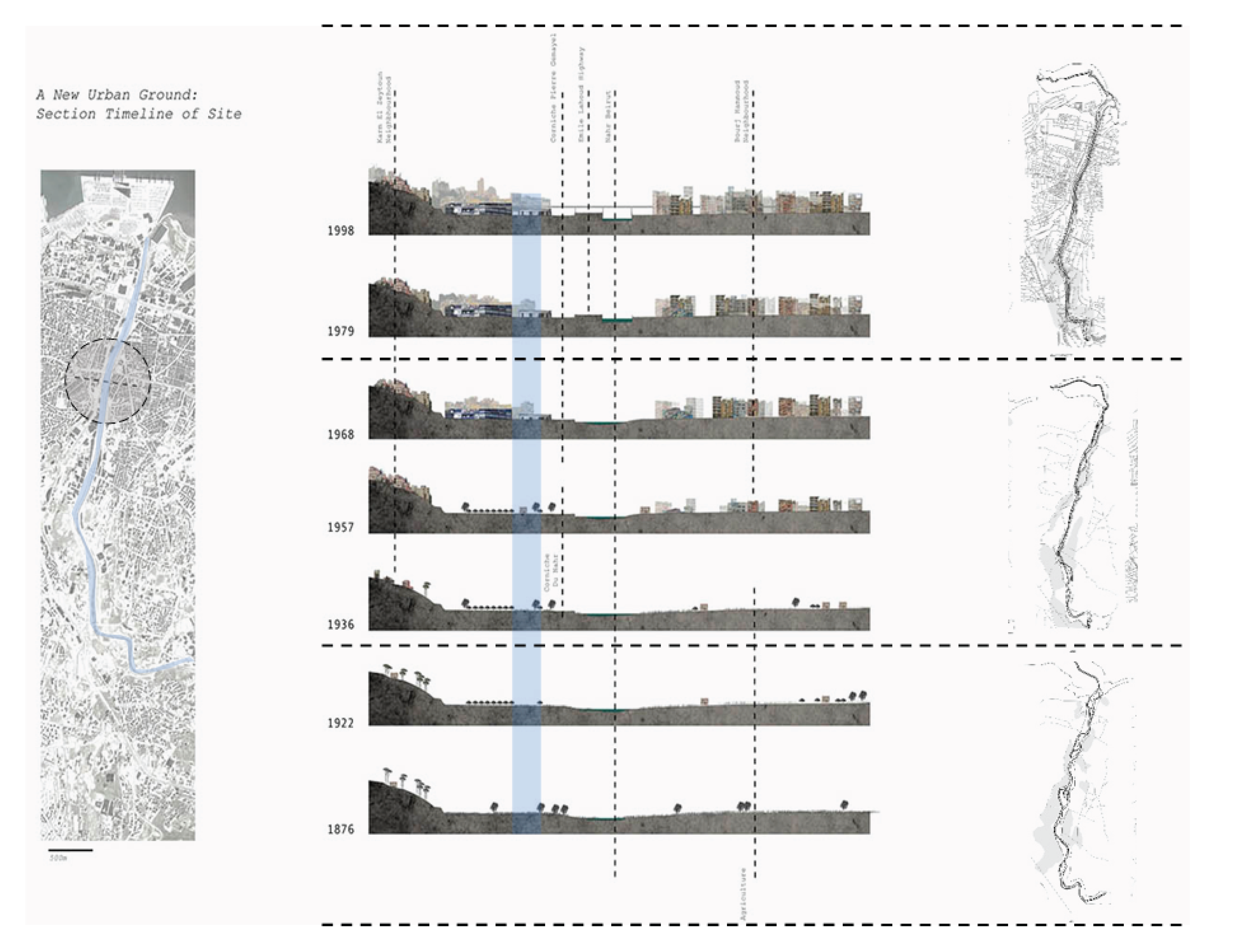
The Beirut River, the city’s largest open river, emerges thirty kilometres inland from two points in Hammana and Tarchiche at an altitude of around 1900 meters. Throughout time, the river has been used as a water re - source for drinking and irrigation. It also once had an important role as a space for recreational activities. In 1968, the river was transformed from a natural, healthy, and performing ecosystem to a canalized infrastructure, becoming an open sewer of domestic and industrial wastewater, highly polluted and posing numerous health risks to its neighbours. The river also lost its recreational and social function as people no longer had access to it.
The Beirut River watershed is characterized by three landscape typologies: urban, peri-urban, and natural; it flows through thirty municipalities and four districts: Beirut, Matn, Baabda, and Aley. It is recharged by rainfall and snowmelt, with a total annual discharge equal to 100 million m2. Moreover, its hydrological cycle is influenced by 190 sources that are located in the area of its watershed. The river has two cycles: a dry season from May till November and a wet season from December until April.
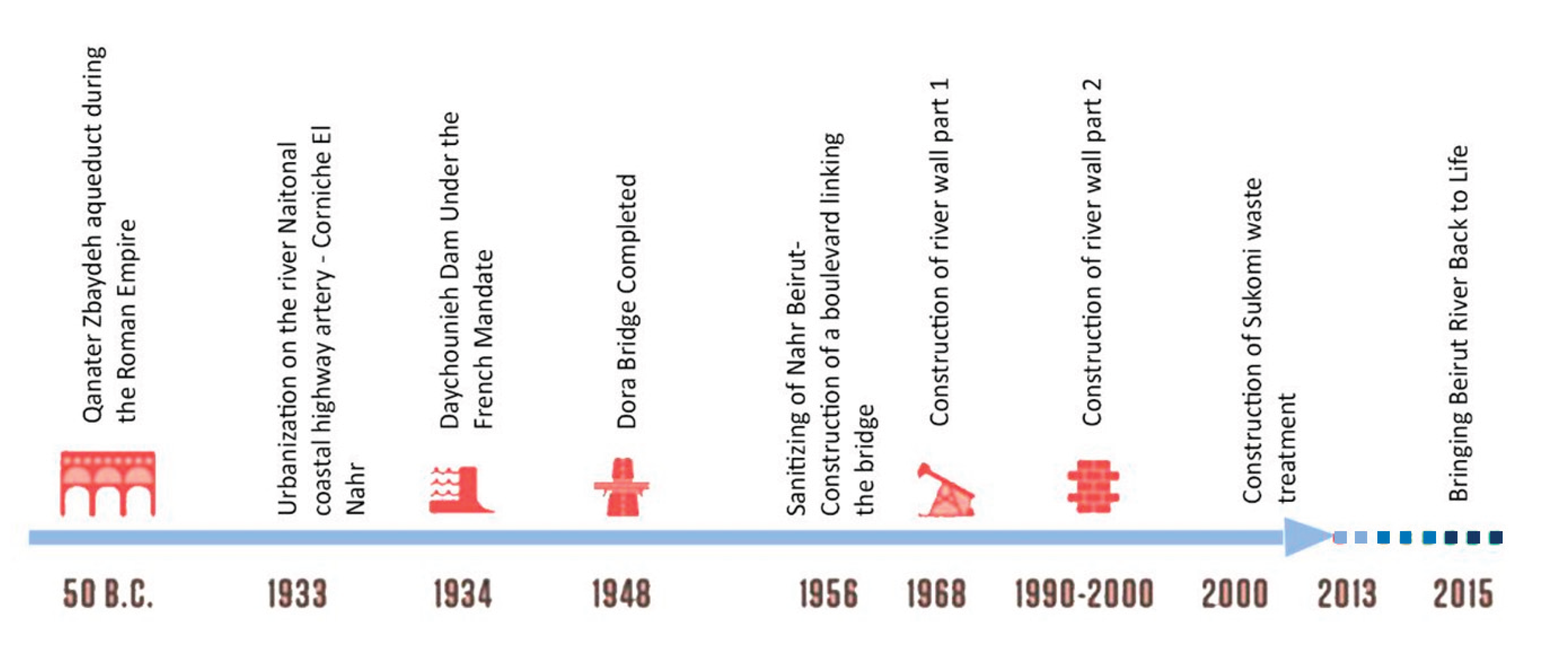
Around 50 BCE, the Romans diverted water from the Daychounie area to the Roman city (located in today’s Beirut downtown area) through a system of dams, canals, aqueducts, and tunnels, used for potable water. Parts of the aqueduct ruins still remain in the Daychounie area, in the valley between Mansourieh and Hazmieh. During the nineteenth century and first half of the twentieth century, the river water was mainly used for agricultural purposes. In 1934, during the French man - date period, the French built a dam in the Daychounie area in an attempt to modernize agriculture. However, sediments filled the storage capacity of the dam, not only ruining the efficiency of the structure but also affecting the water flow of the river and its ecosystem. During the 1940s, the Armenian refugees who originally located in the Quarantina area were relocated to Achrafieh and Bourj Hammoud and settled on both sides of the river. The arrival of new population groups pushed settlements into the flood plains, and consequently, the first floods affecting these settlements were recorded.
The floods of Beirut River and, more specifically, the floods of Abou Ali River in Tripoli in 1955, which killed 160 people, brought forward the idea of canalizing some of the largest rivers, including Beirut River. In 1968, the river was canalized from the waterfront to Furn el Chebbak and in 1998 further canalized to Jisr el Bacha. Moreover, the highway of Emile Lahoud was also completed in 1998.
Figure 12.
Timeline showcasing the historical period of Beirut River.
Figure 12.
Timeline showcasing the historical period of Beirut River.
6.2. Urban Analysis of Nahr Beirut
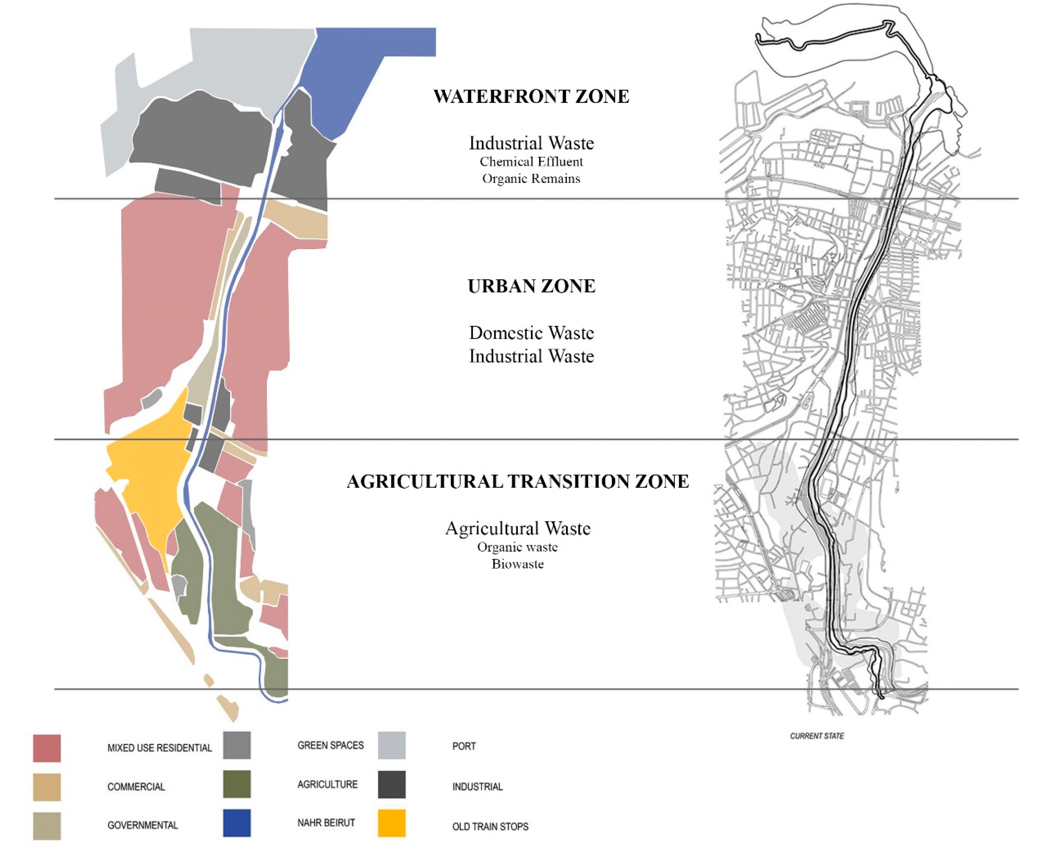
Since Beirut has a natural significance of flowing form the mountains, into the city, and onto the Mediterranean Sea, scholars have divided the Beirut River can be divided into three main zones based several land uses which are: the waterfront zone, the urban zone, and the agricultural transition zone.
The waterfront zone is dominated by industry, where walls clearly mark the public space, separating factories from the water's edge. Unfortunately, the current waterfront faces several challenges. A 30-year-old landfill and an old, polluted fishing port sit alongside a beach and estuary similarly affected by industrial waste. A waste treatment plant and port markets add to the complexities. Furthermore, a slaughterhouse stands at the intersection of the port and the sprawling industrial zone behind it.
The water channel itself starts at 43 meters wide, gradually narrowing with an average depth of 3 meters. It stretches for the first 2.4 kilometres with a gentle slope, but during floods with a flow of 1100 cubic meters per second, the water velocity can reach a concerning 5.7 meters per second.
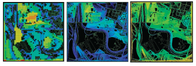
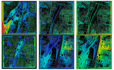
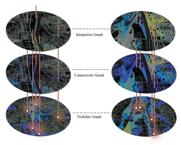
The spatial syntax graphs in each Beirut River zone showcases:
visibility graph for analysing the visibility of the Beirut River within its context (images on the left). The blue colour indicates spaces with poot visibility while the red indicated people with rich visible status to the Beirut River (social impact)
the axial graph which demonstrates the connectivity of the surrounding with the Beirut River (middle images)- the blue indicates roads with least connectivity to the river, while the red showcases areas with efficient accessibility (economic impact)
the isovist map which showcases the integration/ permeability of the river with its surrounding (images on the right) (environmental impact)
Figure 13.
Beirut River Classifications in Each Zone.
Figure 13.
Beirut River Classifications in Each Zone.
6.2.1. The Agricultural Transition Zone
This composes the largest open space amongst the three parts, The Agricultural zone or the upper Beirut River primarily consists of open agricultural fields, bordered by railway stations, and represents the last significant expanse of open space in Beirut. Here, the channel narrows and its walls become taller, measuring 23 meters wide, 7 meters high, and sloping at 6.5%. Beginning in this area, the channel is bordered on both sides by strips of vegetation that act as buffers between the adjacent roads, continuing in this manner until the channel ends in the valley section.
Figure 14.
Graphic Analysis Images showcasing the visibility, connectivity, and integration of surrounding context with the Beirut River in the Agricultural Transition Zone.
Figure 14.
Graphic Analysis Images showcasing the visibility, connectivity, and integration of surrounding context with the Beirut River in the Agricultural Transition Zone.
6.2.2. The Urban Zone
The urban area includes compact residential districts on the Bourj Hammoud and Sin El Fil side, along with an institutional area on the Beirut side, beyond which lie the residential neighborhoods of Achrafieh. In this section, the waterway is situated between the regional highway on Beirut's side and a local road on the opposite bank. This zone is characterized by a shortage of green spaces and open areas. It measures 35 meters wide by 5 meters high, extending for 1.65 km with a slope of 3.5%.
Figure 15.
Graphic Analysis Images showcasing the visibility, connectivity, and integration of surrounding context with the Beirut River in the Urban Zone.
Figure 15.
Graphic Analysis Images showcasing the visibility, connectivity, and integration of surrounding context with the Beirut River in the Urban Zone.
6.2.3. The Waterfront Zone
The final step of the runoff river- the waterfront zone- which is primarily industrial, and characterized by a clear division between public and private areas marked by concrete property walls. Existing features include a 30-year-old landfill, an old fishermen's port, a beach, and an estuary. These areas are affected by pollution from industrial outfall canals, a waste treatment plant, and the port's markets. The slaughterhouse is located at the intersection of the port and the industrial zone. In this section, the channel is 43 meters wide and gradually narrows towards the tip, with an average height of 3 meters. It extends over the first 2.4 kilometers with a slope of 1.5%.
Top of Form
Figure 16.
Graphic Analysis Images showcasing the visibility, connectivity, and integration of surrounding context with the Beirut River in the Waterfront Zone.
Figure 16.
Graphic Analysis Images showcasing the visibility, connectivity, and integration of surrounding context with the Beirut River in the Waterfront Zone.
6.3. Current Issues in Beirut River
The river thus became a no-man’s-land and a dumping ground affected by every crisis the city has gone through: the dumping of slaughterhouse waste when the illegal slaughterhouses scandal came to light; the dumping of garbage during the nine-month long garbage crisis; a regular dumping ground for textile dyes, which turn the river bright red; even an unloved crocodile pet was dumped and found living there. Not to mention the raw sewage infrastructure that is directly connected to the river. After passing through and affecting the urban neighbourhoods downstream, all of this pollution is dumped into the Mediterranean Sea, making it a local problem with a major global impact.
6.3.1. Pollution Levels
Pollution levels in the Beirut River vary depending on the land use along its banks. In the canalized section of the river, three main sources of pollution are identified: industrial effluents from industrial cities, sewage, and pesticides from agricultural irrigation water. This pollution is particularly noticeable in the summer when the river dries up, turning into an open sewer. Additionally, the river receives solid waste from construction material factories in Mkalles and organic waste from the slaughterhouse in Quarantina. In the valley, domestic waste and wastewater discharges intercept the sources of the Beirut River, contaminating both surface water and groundwater tables.
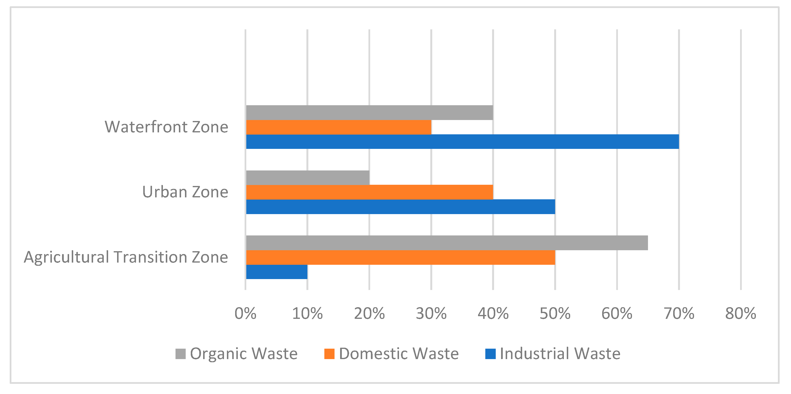
Figure 17.
Land Use in the Beirut River Context and its Relation with the Level and Type of Pollution. Source: Author.
Figure 17.
Land Use in the Beirut River Context and its Relation with the Level and Type of Pollution. Source: Author.
As shown in
Figure 18, the diverse land uses bordering the sections of the Beirut River significantly impact its pollution levels and composition. Dense residential areas on one side likely contribute to domestic wastewater discharge and organic matter pollution. On the other side, institutional buildings might introduce chemical pollutants from cleaning products or laboratory waste.
In Beirut River, the waterfront and urban zones of rivers tend to have higher pollution rates compared to agricultural transition zones, and can be summed up as follows:
Waterfront Zone: Pollution rates in this zone could range from 50% to 70% or higher, depending on the extent of industrial activities, waste discharges, and urban development along the riverbanks.
Urban Zone: Pollution rates in urban areas could range from 30% to 50%, influenced by factors such as population density, sewage infrastructure, and industrial presence.
Agricultural Transition Zone: Pollution rates in agricultural areas might be lower, ranging from 10% to 30%, as these zones are typically less affected by direct industrial discharges and urban runoff.
6.3.2. Analysing the Space Syntax for Beirut River
Analysis of the space syntax graphs reveals significant differences in visibility, connectivity, and integration between the three zones of the Beirut River: the waterfront zone, urban zone, and agricultural transition zone. The urban zone stands out as having the most deficiencies in these aspects, highlighting its status as the most impacted and neglected zone among the three.
In terms of visibility, the urban zone suffers from limited visual connections and sightlines, likely due to its densely built environment and lack of open spaces. This impacts the overall environmental quality of the area, as well as the sense of safety and security for its residents.
Connectivity analysis indicates that the urban zone has the poorest connectivity, with fewer direct routes and pathways compared to the other zones. This lack of connectivity can hinder accessibility and mobility within the urban zone, affecting its economic vitality and social cohesion.
Integration analysis further emphasizes the challenges faced by the urban zone, as it shows lower levels of integration compared to the waterfront and agricultural transition zones. This lack of integration indicates a fragmented and disjointed urban fabric, which can lead to social isolation and disconnection.
Therefore, the paper will focus on the zone that is most neglected and deprived, which is the urban zone. The urban zone also negatively impacts the waterfront zone, where the accumulation of pollution and runoff to the waterfront zone and into the sea.
6.3.3. Space Syntax Overlap for Urban Acupuncture Points
As shown in
Figure 19, a clearer image showcasing only the blue hues (weak and poor visibility and connections), which demonstrates clearly, between the three graphs, of the areas that need regeneration within the peripheries of the Beirut River to enhance its environmental, social, and economic aspects.
The visibility graph, connectivity graph, and integration graph are valuable tools for understanding the economic, social, and environmental impact of urban spaces.
The visibility graph, which analyzes visual connections between different parts of an urban area, can help urban planners and designers create safer and more attractive environments. By identifying areas with poor visibility, interventions can be planned to improve surveillance and security, ultimately enhancing the economic viability of these areas.
The connectivity graph, which examines the ease of movement between different locations in an urban area, is crucial for enhancing accessibility and mobility. A well-connected urban fabric can improve the efficiency of transportation networks, stimulate economic activity by facilitating access to markets and services, and enhance social interactions by reducing travel times and distances.
The integration graph, which measures the degree of connectivity between different segments of an urban area, is essential for promoting social cohesion and inclusivity. Higher levels of integration indicate a more connected and cohesive urban fabric, which can contribute to a stronger sense of community and belonging among residents.
Overall, these graphs provide valuable insights into the spatial structure and organization of urban areas, helping policymakers, planners, and designers make informed decisions that can have positive impacts on the economic, social, and environmental aspects of urban life.
6.4. Author’s Perspective on Urban Acupuncture Interventions
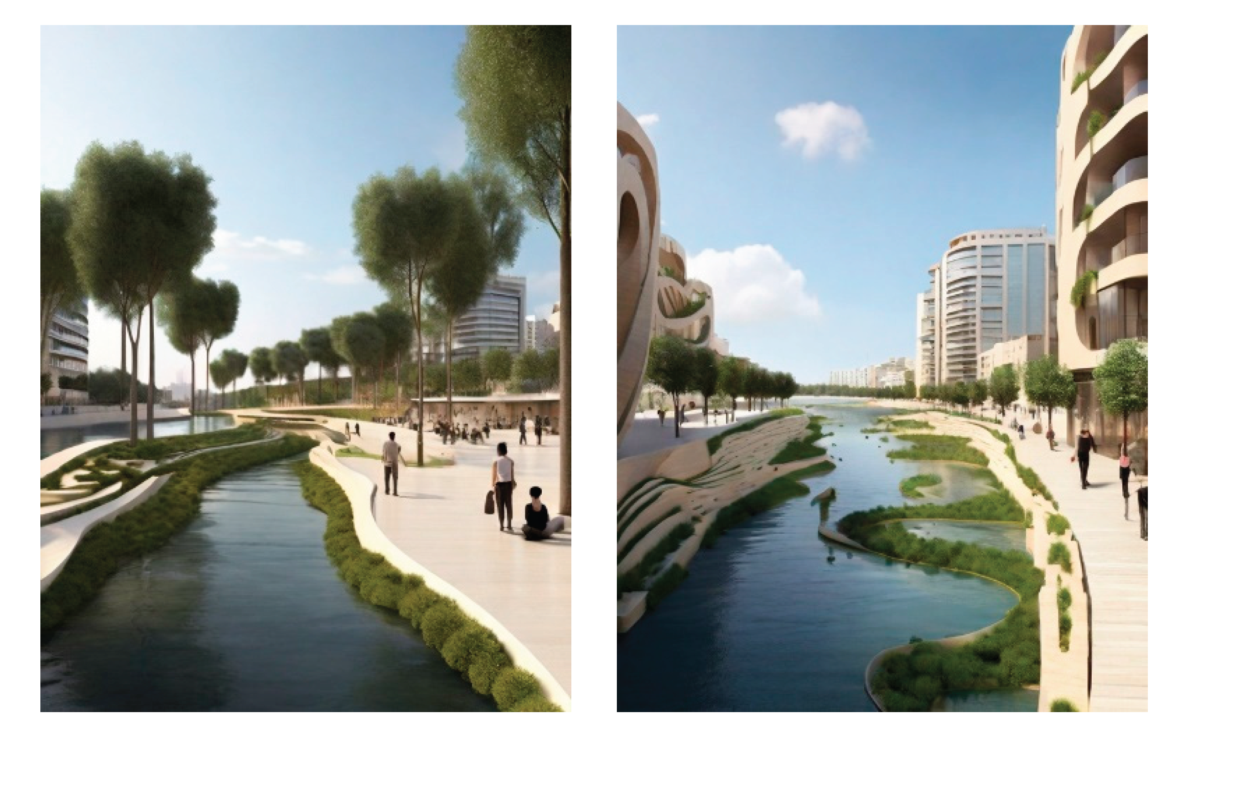
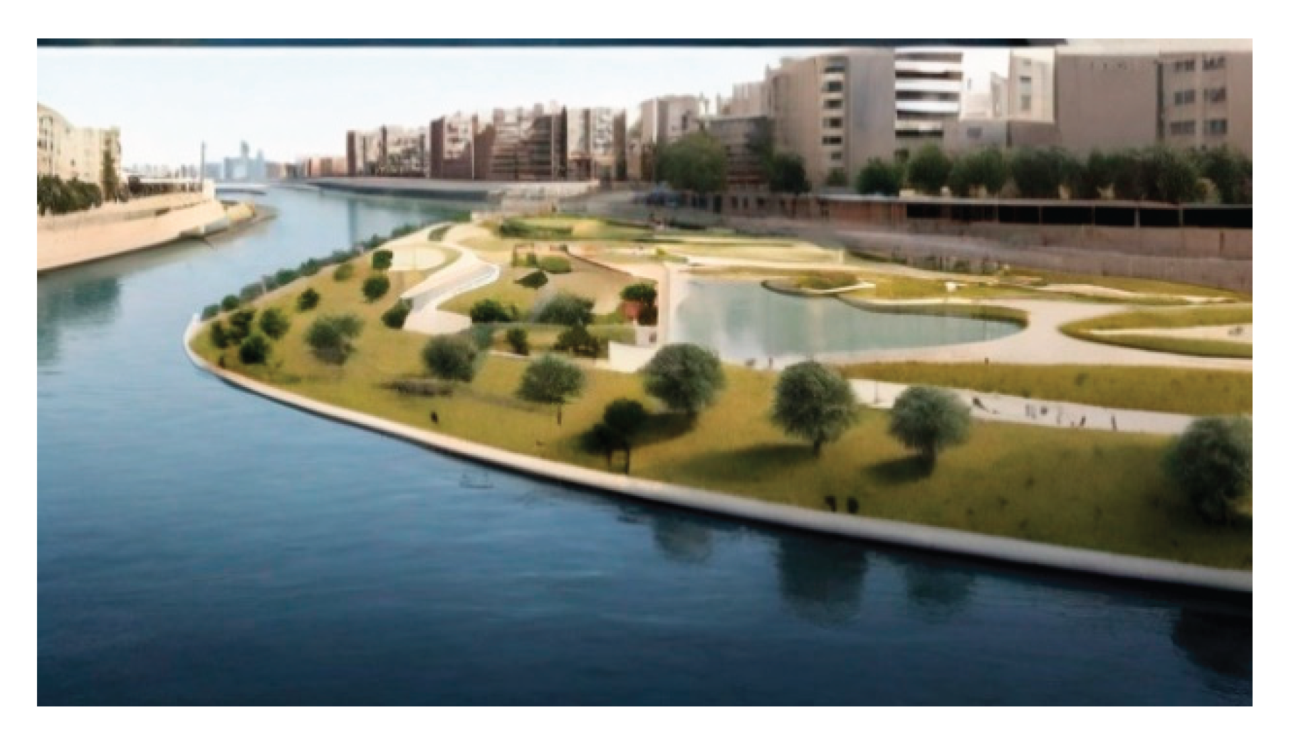
After conducting the space syntax survey which allocated the urban spots that are mostly degraded, the author created a set of sketches more visual clarity. The design decisions were generated by AI (LeonardoAI) for a clearer conceptual approach of the possible enhancement for the river peripheries. The proposals included some factors such as bio-concrete construction of the river’s surrounding walls, sponge pocket parks, pedestrian walking trails, trees as buffering zones, seating areas, and retention ponds.
Figure 21.
Conceptual sketches rendered by LeonardoAI.
Figure 21.
Conceptual sketches rendered by LeonardoAI.
7. Conclusions
Blue urban acupuncture offers a powerful approach to revitalizing urban environments through strategic, small-scale interventions focused on waterfronts and waterways. By weaving together ecological restoration, public space creation, and economic development opportunities, this methodology can unlock the hidden potential of our rivers, canals, and coasts.
Finally, according to the issues raised in this study, it can be concluded that:
Urban Acupuncture method is suited for developing or underdeveloped cities, where low-cost, efficient measures can be taken to swiftly regenerate a specific site.
Developing riversides is crucial for social, environmental, and economic growth within the city.
Space syntax can be used to create layers for the visibility, connectivity, and integration
of surrounding with the river to further analyse the highly degraded areas to inevitably apply small-scale interventions within to greatly enhance the surrounding context.
By implementing small-scale interventions such as creating green corridors, developing waterfront parks, and improving water quality, the Beirut River can be transformed into a vibrant and sustainable urban space. These interventions not only enhance the ecological health of the river but also create valuable public spaces for recreation and community engagement.
The integration of blue urban acupuncture principles can stimulate economic development by attracting investments and tourism to the revitalized riverfront.
References
- Apostolou M (2015), Urban Eco-Acupuncture Methods: Case Study In the City Of Athens. 2nd International Conference on Changing Cities II: Spatial, Design, Landscape & Socio-economic Dimensions. Jun 2015, Porto Heli, Greece p.945-948.
- Beirut’s Public Space (or lack thereof) (2009), Beirut, http://www.nowlebanon.com/NewsArticleDetails.aspx? 31 July 8527.
- Benedict, M. A. , & McMahon, E. T. (2002). Green infrastructure: Linking landscapes and communities. Island Press.
- BlueHealth 2020 project. (2021). Publications. Retrieved from https://bluehealth2020. 2021.
- Brandligt, V. I. , van der Jagt, A. P., Aerts, J. C. J. H., & Oudes, A. (2021). From blue dreams to reality: Governance challenges and opportunities for the successful implementation of blue urban acupuncture. Land Use Policy, 102, 105190.
- Casagrande, M. (2015) From urban acupuncture to the third generation city. In J. Revedin (ed.) La ville rebelle. Démocratiser le projet urbain. Gallimard, Paris.
- Chamseddine, R. (2017). An alternative landscape vision for Bisri: Rethinking the dam.
- Eid-Sabbagh, K and Ray, A, (2021). Breaking Point: The Collapse of Lebanon’s Water Sector. Policy Paper. Triangle.
- Fletcher, T. D. , Sherratt, T. D., & Sponge City Working Group. (2014). Sponge city: A new paradigm for urban stormwater management in China. Water Resources Research, 50(6), 3921-3931.
- Fletcher, T. D. , Sherratt, T. D., & Sponge City Working Group. (2020). Sponge city: A new paradigm for urban stormwater management in China. Water Resources Research, 56(12), e2020WR029159. (https://www.mdpi. 2073. [Google Scholar]
- Hopton, R., A. , and M., (2011). “Cheonggyecheon Stream Restoration Project.” Landscape Performance Series. Landscape Architecture Foundation,. [CrossRef]
- Houri, A. and El Jeblawi, S.W. 2007. [Google Scholar]
- https://phys.org/news/2022-08-groundwater-tables-streams-rivers-seep.
- Lara-Hernandez, J. A. , Melis, A. ( 2018) Understanding the temporary appropriation in relationship to social sustainability. Sustainable Cities and Society 39, 366–374.
- Lerner, J. , & Ribeiro, C. T. (2014). Urban acupuncture: Injections in the urban body to generate sustainable, healthy and diverse cities. Abingdon, Oxon: Routledge.
- Loder, A. , Gnandt, I., & Pettygrove, S. (2017). The role of temporality in understanding social-ecological dynamics: Insights from blue urban acupuncture. Environmental Research Letters, 12(2), 025006.
- Ludvigsen, Børre (2008). The Lebanese State Railway Company. http://almashriq.hiof.no/lebanon/300/380/385/railways/index.
- Marletto, G. , Sillig, C. (2019). Lost in mainstreaming? Agrifood and urban mobility grassroots innovations with multiple pathways and outcomes. Ecological Economics 158, 88–100.
- Meerow, S. , & Lehmann, S. (2016). Socio-hydrological responses to river restoration: A review of interdisciplinary studies. Environmental Research Letters, 11(3), 033001.
- MoE (Ministry of Environment), (2020), Lebanon State of the Environment and Future Outlook: Turning the Crises into Opportunities (SoER 2020). With UNHCR, UNICEF and UNDP.
- MoEW (Ministry of Energy and Water), (2010). National Water Sector Strategy.
- Moschella, D. , Loder, A., & Armstrong, D. (2020). Moving beyond the hype: Evaluating the potential and limitations of blue urban acupuncture. Environmental Science & Policy, 114, 84-94.
- Shaban, A and Darwish, T, (2011). ‘The role of sinkholes in groundwater recharge in the high mountains of Lebanon.’ Journal of Environmental Hydrology 19:1-11.
- Shaban, A. S: “Rivers of Lebanon, 2021.
- Stokman, Antje (2008), Water Purificative Landscapes – Constructed Ecologies and Contemporary Urbanism. In: Kuitert, Wybe.Transforming with water. Proceedings of the 45th World Congress of the International Federation of Landscape Architects IFLA 2008, Blauwdruk/ Techne Press,Wageningen, pp.
- The World Bank Data, n.d. Renewable internal freshwater resources per capita (cubic meters) – Lebanon.
- Theilmann,K.,(2022), ‘If groundwater tables drop, streams and rivers seep away and pollute drinking water’.
- Ulrich, R. S. (1993). Biophilia and biophobia. The Phoebe Hearst Lectures Series. John Wiley & Sons.
- UNDP (United Nations Development Programme), (2014), Assessment of Groundwater Resources of Lebanon.
- van Steenbergen, N. , Weijs, S., Mees, H., De Schutter, K., & Leuven, R. (2021). Urban blue acupuncture: A protocol paper. International Journal of Environmental Research and Public Health, 18(10), 4084.
- Vassiljev, P. , Bell, S., Balicka, J., Ali, A. U. A. (2020). Urban blue acupuncture: An experiment on preferences for design options using virtual models. Sustainability 12, no. 24, 10656.
|
Disclaimer/Publisher’s Note: The statements, opinions and data contained in all publications are solely those of the individual author(s) and contributor(s) and not of MDPI and/or the editor(s). MDPI and/or the editor(s) disclaim responsibility for any injury to people or property resulting from any ideas, methods, instructions or products referred to in the content. |
© 2024 by the authors. Licensee MDPI, Basel, Switzerland. This article is an open access article distributed under the terms and conditions of the Creative Commons Attribution (CC BY) license (http://creativecommons.org/licenses/by/4.0/).
