
Submitted:
08 May 2024
Posted:
08 May 2024
You are already at the latest version
Abstract
The NW-SE trending dextral strike-slip faults on the north side of the Tian Shan play an important role in accommodating the crustal shortening, which mainly includes the Karatau fault, Talas-Fergana fault, Dzhalair-Naiman fault, Aktas fault, Dzhungarian fault (also named Bolokenu-Aqikekuduk fault) and Chingiz fault. The classic viewpoint is that the strike-slip fault is the adjustment product caused by the difference of the crustal shortening from west to east. Another viewpoint attributes the dextral strike-slip fault to large-scale sinistral shearing. The Alakol Lake Fault is situated along the northern margin of the Dzhungarian Gate, stretching for roughly 150 km from Lake Ebinur to Lake Alakol. Our team utilized aerial photographs, Satellite Stereo-imagery, and field observation to map the distribution of the Alakol Lake fault. Our findings provided evidence supporting the assertion that the fault is a dextral strike-slip fault. In reference to its spatial distribution, Lake Alakol is situated in a pull-apart basin that lies between two major dextral strike-slip fault lines: the Chingiz and Dzhungarian faults. The Alakol Lake Fault serves as a connecting point for these two faults, resulting in the formation of a mega NW-SE dextral strike-slip fault zone. According to our analysis of the dating samples taken from the alluvial fan, as well as our measurement of the displacement of the riser and gully, it appears that the Alakol Lake fault has a dextral strike-slip rate of 0.8-1.5mm/yr. The strike-slip rate of the Alakol Lake fault is comparatively higher than that of the Chingiz fault in the northern region (~0.7 mm/yr), but slower than that of the Dzhungarian fault in the southern (3.2-5 mm/yr). The Chingiz-Alakol-Dzhungarian fault zone shows a gradual decrease in deformation towards the interior of the Kazakhstan platform. We contend that the rate of deformation observed is better explained by the crustal shortening adjustment model, rather than the large-scale sinistral shearing model.
Keywords:
Alakol Lake fault
; dextral strike-slip
; Slip rate
; UAV photogrammetry
; Satellite Stereo-imagery
1. Introduction
Central Asia has experienced extensive Cenozoic deformation and an active orogenic belt due to the impact of the India-Eurasia collision [1,2]. One of the most representative orogenic belts is the Tian Shan, which underwent reactivation in the Cenozoic [3,4,5,6]. The Tian Shan is an active intracontinental orogenic belt that extends east-west for 2500 km and south-north for 250-350 km, making it one of the most significant orogenic belts in the world. Since the Quaternary period, the Tian Shan has undergone strong tectonic deformation such as compression and uplift, and rapid north-south crustal shortening [3,7,8,9,10,11]. Faults of the Tian Shan accommodate the crustal shortening, which includes the E-W trending thrust faults [3,12,13,14,15], the ENE-WSW trending sinistral strike-slip faults [2,16,17], the NW-SE trending dextral strike-slip faults [18,19,20]. The GPS data indicates that the total shortening rate is approximately 20 mm/yr across the western Tian Shan to the Kazakh Platform, which is nearly half of the total convergence rate between India and Eurasia [21,22,23,24]. The NW-SE dextral strike-slip faults on the north side of the Tian Shan play a crucial role in accommodating crustal shortening, including the Karatau fault, Talas-Ferganas fault, Dzhalair-Naiman fault, Aktas fault, Dzhungarian fault (also named Bolokenu-Aqikekuduk fault), and Chingiz fault [2,19,25]. Multiple viewpoints exist on the formation mechanisms of strike-slip faults in the Tianshan orogenic belt areas. The classic viewpoint suggests that the strike-slip fault is an adjustment product caused by the difference in east-west crustal shortening [2,3,26]. Another viewpoint attributes the dextral strike-slip fault to large-scale sinistral shearing [27,28].
The Dzhungarian fault is the large NW-SE trending dextral strike-slip fault, which extends for more than 700 km long and represents the boundary line between the north Tian Shan and the middle Tian Shan (Figure 1a) [19,20,25,29]. According to previous studies, the Dzhungarian fault has a slip rate of 2.2-3.2 mm/yr in its middle segment [19,20], and ~1.7 mm/yr at the end of the northwest segment in the late Quaternary [30]. The Chingiz fault (CF) is a NW-SE trending dextral strike-slip fault that runs for over 600 km long in the east-central Kazakhstan Platform [31,32]. It can be seen from Landsat satellite images that the Chingiz fault has distinct linear fault traces [32]. In the Cenozoic, the Chingiz fault has the typical dextral strike-slip characteristic with a small thrust component [31]. The GPS data indicate ~0.7 mm/year of the dextral strike-slip rate in the Chingiz fault [33]. Dzhungarian fault and Chingiz fault are more than 100 km apart and arranged in steps to the right, with Lake Alakol in the middle of them. A nearly 150-km-long fault along the northeast Lake Alakol to Dzhungarian gate is called the Alakol Lake fault (ALF). The spatial distribution of the Alakol Lake fault seems to connect the Chingiz fault and the Dzhungarian fault (DZF; Figure 1a). However, the formation process of these faults and their connection have not been well studied, which hampers our understanding of how the Tian Shan moved and evolved.
Besides, the GPS velocities with respect to the stable Eurasia decrease from approximately 4 mm/year in the Ili Basin to less than 2 mm/year in the northwest margin of the Junggar Basin. This indicates that the DZF and ALF accommodate around 2 mm/year of crustal shortening in the N320°W (Figure 1c). However, it is still unclear what the geometric characteristics of the Alakol Lake fault are and how it absorbs crustal shortening.
Exploring the geometric structure and kinematic characteristics of the Alakol Lake fault is essential for understanding its structural relationship and block deformation with the two large strike-slip faults (DZF and CF). The Alakol Lake fault is located near the important trade ports of Alashankou in China and Dostyk in Kazakhstan. Therefore, investigating the kinematic properties of the fault is crucial for assessing seismic risk in both cities.
In this study, we have identified the dextral strike-slip characteristics of the Alakol Lake fault using high-precision aerial photographs, satellite stereo-imagery, and field observations. We then described the detailed fault traces and tectonic features such as alluvial fan surfaces, gullies, offset stream channels, and fault scarps based on the obtained data. Finally, we discussed the role of the Alakol Lake fault in the tectonic pattern formed in the north of Tian Shan.
2. Geological Setting
The western Junggar is a significant part of the Central Asian orogenic belts, which lies between the Kazakh Platform to the west, the Junggar Basin to the east, the Borohoro Mountain range to the south, and the Altai Shan to the north (Figure 1a). The western Junggar has undergone a multiple-stage orogenic evolution since the Early Paleozoic, including multiple-phase subduction of the Paleo-Asian oceanic plate, crustal accretion, and continental growth [35,36,37]. This region primarily consists of a series of accretionary complex belts and Paleozoic magmatic arcs [38,39]. The main exposed strata in the western Junggar are volcanic sedimentary strata from Ordovician to Carboniferous, and the most widely distributed are carboniferous thick pyroclastic sedimentary formations. The magmatic activity in the western Junggar area was particularly intense in the late Paleozoic, and granites with positive εNd(t) and low initial 87Sr/86Sr characteristics were widely distributed in the region [40,41,42,43]. In the western Junggar, large sinistral and dextral strike-slip faults are mainly developed. The sinistral strike-slip faults include the ENE-WSW trending Daerbute fault (DF), TuoLi fault (TLF), and East Tacheng fault (ETF) (Figure 1a). The dextral strike-slip faults include the NW-SE trending Chingiz fault (CF), Dzhungarian fault (DZF), and Kashihe fault (KSHF) (Figure 1a).
Junggar Alatau is located in the north of the western Tian Shan, and the overall trend is nearly east-west (Figure 1a). The Alatau Mountain borders between China and Kazakhstan, an important part of the Central Asian orogenic belts. Junggar Alatau mainly developed late Paleozoic strata and Cenozoic sediments [44,45]. The bedrock of Junggar Alatau is well exposed, and the strata are mainly late Paleozoic clastic rocks and carbonate rocks. There are frequent magmatic activities, a large distribution area of igneous rocks and diverse rock types in the Junggar Alatau [46].
The ALF lies in the western Junggar, which extends about 150 km from the northeast of Lake Ebinur (45°1′N, 82°59′E) to the eastern end of Lake Alakol (46°8′N, 82°1′E) (Figure 1a). It stretches across two countries and can be divided into two segments by the border between China and Kazakhstan. The northwest segment in Kazakhstan extends for ~70 km near the edge of Lake Alakol, and its surrounding landforms are mostly green vegetation (Figure 2). The southeast segment in China extends for ~80 km to the north of Lake Ebinur and its surrounding landforms, mostly the Gobi Desert. The strike of the ALF is from 315° to 330°, and the overall strike of the fault is 320°. According to the 1:500,000 geological map compiled by China, previous research dates, and field observations, the bedrocks around the Alakol Lake fault are Paleozoic rocks, mainly including Ordovician marine sedimentary rocks and Carboniferous volcanic rocks [47]. Combined with the field investigation, the geomorphic surface of the area of the ALF is mainly Quaternary alluvial deposit and Gobi. There are four stages of alluvial fans in the research area, which are T1, T2, T3, and T4. T1 is the lowest alluvial fan, which is 6-14 m high above the channel. T2 and T3 are 18-20 m and 24-50m high above the stream bed respectively. T4 is the highest alluvial fan in the study area, preserved well and more than 50m above the stream bed. The alluvial fan, which is older than T4, has been eroded into pieces. It can only be distinguished by the distribution range based on the lithology in satellite images.
3. Methods
3.1. Drone Digital Elevation Models and Other Image Data
In the research of the Alakol Lake fault, we require a set of quantitative parameters to elucidate its kinematic characteristics, activity intensity, and activity patterns. These parameters include horizontal displacement of the alluvial fan surfaces, stream channels, gullies, and ridges; vertical displacement of the fault scarps; and the age of these geomorphic surfaces [48,49,50]. The high-precision and high-resolution topographic and geomorphic data that can reveal subtle geomorphic features are the basis of the quantitative study of active structures [49,51]. We achieved these conditions using the core concept of structure from motion (SfM), a photo-based technique for three-dimensional (3D) reconstruction to create a high-resolution digital elevation model (DEM) [52,53,54]. The SfM is a technique to reconstruct a 3D scene from a flat image, and it can recover the relative position and attitude of the camera from the disordered image with a certain overlap degree by image feature extraction and matching [55]. Using the Structure from Motion (SfM) technique, we employ an unmanned aerial vehicle (UAV) (DJI Phantom 4 RTK) to create orthoimages and high-resolution DEMs with a pixel resolution of less than 0.1 meters. In these areas where we use the UAV, the UAV flies at a height of 120-220 m, with a 70% forward and side overlap at each site. Through this process, we obtained hundreds of images with a resolution of 5472 pixels in width and 3648 pixels in height for each site. These images of each site were generated using high-resolution DEM software integrated with SfM algorithms. DEMs with a resolution of less than 10 cm can clearly display various topographic indexes, such as hillshades, contour lines, and slopes.
When observing large-scale landforms, using the UAV photogrammetry technique based on SfM may not be sufficient to achieve the desired effect. Therefore, utilizing Pleiades satellite images to generate high-resolution DEM is another effective method. We use two stereo pairs of Pleiades images to construct a 0.5 m resolution DEM. The 0.5m resolution of the DEM is high enough to identify hundreds of meters’ horizontal offsets of alluvial fans and displaced stream channels.
However, due to certain conditions, it is still difficult to obtain high-resolution DEM in some regions, especially the ~70 km-long fault of the northwest segment (in Kazakhstan). Therefore, using Google Earth to extract images for identifying the kinematic evidence of the northwest segment is an extremely efficient and convenient method for revealing the fault trace and displaced stream channels.
3.2. Offset Measurements of Landforms
The displacement of a fault can be measured by the distance between two correlation marker units projected onto the fault trace. [49,56,57]. Additionally, the confidence ratings express the reliability of the original morphology of the offset markers, and an offset range is assigned to every measurement to describe the physically plausible range of an offset measurement. [49,58,59].
The alluvial fans are typically formed when flowing water interacts with mountains. The mountain on the north side of the ALF brought many material sources and formed multiple alluvial fans in front of the hill. The size and shape of these fans were identified using the orthoimage and DEM. Then, we checked each horizontal offset feature and traced the channel or the riser of alluvial fans on both sides of the fault as straight line. The next is to measure the distances between the projections of upstream and downstream fitted straight lines to the fault plane. Due to lateral erosion of the channel near the fault, it is difficult to trace an accurate offset landform [56]. We measured the maximum and minimum offset possibilities and expressed the form with the average value and error type to identify the offset range. As a result, the offset range does not represent a confidence interval.
The width of the gully and ridge is usually less than the width of the stream channel, so we can directly make linear fitting of the gully (bottom of the gully) and ridge (top of the ridge) on both sides of the fault trace. The projections of the fitted line to the fault are measured as the horizontal offset. Their offset range is measured similarly to that of the stream channel.
Different fault scarps of varying heights were formed along the fault in various geomorphic surfaces due to the vertical displacement of the fault. To obtain the vertical displacement, well-preserved scarps were mapped and identified based on the high-resolution UAV DEM. Then, topographic profiles perpendicular to the fault scarp were extracted. The topographic profiles of the hanging wall and footwall were linearly regressed by two separate straight lines. The vertical distances of the two fitted lines projected to the fault trace were measured to represent the vertical displacement.
In this paper, a method called “Back-slipping” was used to measure the lateral offsets of gullies. After the fault trace and two separated geomorphic marker sections were identified, we back-slipped them along the fault trace to reconstruct the original morphology of the geomorphic markers and determine the offset [59,60,61].
3.3. Chronology Dating
Optically stimulated luminescence (OSL) dating is one of the methods of luminescence dating, which can determine the age of sedimentary strata by measuring the equivalent dose (De, which is the ionizing radiation dose corresponding to the natural OSL signal intensity of quartz and other minerals in the sediment) and the environmental dose rate received by the sample per year (D) [62,63,64]. The age of sedimentary strata is calculated as follows:
Age = De/D
The unit of age is ka. The unit of De is Gy. The unit of D is Gy/ka.
In this research, three OSL samples (AL-01, AL-04, and AL-05) were collected from the capping loess in the alluvial fans, and two OSL samples (AL-02 and AL-03) were collected from the trench wall in the alluvial fans. All samples were carefully collected and sealed in opaque iron tubes. These samples were processed and measured at the National Institute of Natural Hazards, Ministry of Emergency Management of China. The sample pretreatment followed the experimental procedure of Aitken (1998) and Lu et al. (2007), and then relatively pure quartz particles were obtained [65,66]. The equivalent dose (De) was measured using the methods of Murray et al. (2000, 2003) [63,67]. The effects of radionuclides and cosmic rays were measured to determine the dose rate received per year (D) [65,68].
4. Results
4.1. Distribution of the Study Site
The Alakol Lake fault extends 150 km and can be divided into two segments: the southeast segment, located in front of the Western Junggar mountain, and the northwest segment, situated beyond Lake Alakol. The two segments are located in China and Kazakhstan, respectively. Seven study sites were selected along the southeast segment of the Alakol Lake fault in China, and two interpretation sites near the Lake Alakol in Kazakhstan (Figure 2). The southeast segment of the fault was used by the UAV to obtain the high-resolution DEM and was observed in the field (Figures 3–9). Site 7 and 8 also utilized the Pleiades satellite images to generate high-resolution DEMs on a large spatial scale (Figures 8a, 9a). In the northwest segment, one site used the Pleiades satellite images to observe geomorphological characters and displacements (Figure 10), while another used Google Earth to identify the fault trace (Figure 11).
4.2. The Southeast Segment
The southeast segment of the ALF extends for ∼80 km from the northeast Lake Ebinur to the study site 6 (Figure 2). Through remote sensing interpretation and field observations, it was revealed that there was a clear dextral strike-slip movement in this segment. Study sites 1 to 7 were elaborately investigated to describe the structure and geomorphological characters and to measure the vertical and horizontal displacements.
Site 1 is situated ~9 km northeast of Lake Ebinur, as shown in Figure 2. Faults strike N30°W that were found at site 1, with the main fault developing along the edge of the bedrock hill, while the branch cut through the alluvial fan (Figure 3a). There were four stages of alluvial fans (T1-T4) developed along the stream channel. T1 is the lowest alluvial fan, only ~10 m above the bed, and develop on both sides of the fault. T2 is ~20 m high above the stream bed, T3 is ~50 m high above the stream bed, and T4 is ~60 m above the stream bed. T2 and T3 are only reserved on one side of the fault, but the T4 which is the highest and most widely geomorphic surface developed on both sides of the fault. T4 is dextrally displaced by 10 ± 1 m along the main fault, and it is also dextrally displaced by 86 ± 4 m along on branch fault (Figure 3a, 3b). However, it is possible that the dextral displacement of 86 ± 4m could have been exaggerated due to the collapse of the alluvial fan. The fault scarps clearly formed on the T4, and topographic profile A-A’ was extracted to measure the vertical displacement, which indicated that the vertical displacement of the T4 across the fault scarp is 5 ± 0.5 m (Figure 3c). Based on T4 dislocation, the ratio of horizontal displacement to vertical displacement approaches 17:1. On the southeast side of the stream channel, it shows that the red Carboniferous granite thrust on yellow Neogene sandstone and gray Quaternary deposits (Figure 3d). The Neogene sandstone also shows larger vertical dislocations on the riser (Figure 3e).
Site 2 is located ~25 km northwest of site 1 (Figure 2). At this site, the fault trace strikes N45°W. Two alluvial fans and a ridge were displaced along the N40°W direction by the ALF (Figure 4a). The two alluvial fans were dextrally displaced by 20 ± 4 m and 22 ± 1 m, respectively, while the ridge was dextrally displaced by 30 ± 6 m. The topographic profile A-A’ indicates the vertical displacement across the fault scarp is 1.0 ± 0.1 m (Figure 4b). The black line B-B’ shows another dextral ridge and a road crosses the ridge along the location of the fault scarp (Figure 4a). The topographic profile B-B’ indicates the vertical displacement of the dextral ridge is 2.1 ± 0.2 m (Figure 4b). The ratio of horizontal displacement to vertical displacement on the same geomorphic surface is approximately 20:1. The field photograph showed the ridge was dextrally displaced along the fault trace (Figure 4c).
Site 3 is located ~1 km northwest of site 2 (Figure 2). At site 3, the fault trace strikes N40°W and cuts through many alluvial fan surfaces. We identified three stages of alluvial fans at the site, ranging from new to old, and named them fan 1, fan 2, and fan 3. The edge of the fan 3 was dextrally displaced by 34 ± 8 m at the erosional side, while the edge of the fan 2 was dextrally displaced by 48 ± 10 m (Figure 5a). Besides, a pull-apart basin was developed on the fan1 with ~2 m deep, ~400 m long, and ~50 m wide (Figure 5c and 5d). Three topographic profiles (A-A’, B-B’, C-C’) were extracted to measure the vertical displacement. The topographic profile A-A’ on fan 1 indicates that the vertical displacement of two fault scarps, with opposite directions, is 1.8 ± 0.1 m and 1.9 ± 0.4 m, respectively. The topographic profile B-B’ indicates the vertical displacement across the fault scarps on the fan3 is 5.0 ± 0.4 m (Figure 5b). Similarly, the topographic profile C-C’ indicates the vertical displacement across the fault scarp, which developed on fan 2, is 2.2 ± 0.8 m. The ratio of horizontal displacement to vertical displacement on fan 2 is estimated at ~22:1.
Site 4 is located ~2 km northwest of site 3 (Figure 2). At site 4, two gullies were dextrally displaced by 20 ± 3 m and 18 ± 2 m, respectively (Figure 6a). The topographic profiles (A-A’ and B-B’) indicate that the vertical displacements across the fault scarp are 0.7 ± 0.1 m and 2.6 ± 0.2 m, respectively (Figure 6b). Because of the gully dislocation represented minimum offset on the alluvial fan, the ratio of horizontal displacement to vertical displacement on the alluvial fan of site 4 is 8:1, smaller than another site. The filed photo shows the dextrally displaced gully and the fault scarp on the surface of the alluvial fan (Figure 6c). A clear fault scarp that has a distinct vertical displacement can be found on the alluvial fan (Figure 6d). In the field, a fault spring was found with ~3 m diameter and ~4 m depth (Figure 6e). Many reeds and grass grew around the spring and fixed a large amount of sand and soil.
Site 5 is located ~26 km northwest of site 4 (Figure 2). Three stages of alluvial fans (T1-T3) developed along the stream channel at site 5 (Figure 7a and 7c). T1 is the lowest alluvial fan and is severely eroded, which is ~14 m above the stream bed; T2 is ~18 m above the stream bed and is dextrally displaced by 13 ± 1 m along the fault trace; T3 is the highest alluvial fan, which is ~24 m above the stream bed. The ALF separated the two faults, forming the fault scarp on the T2. The stream channel was displaced with 20 ± 4 m of dextral offset on the east branch fault. The smaller dextral displacement of the T2 riser, with 13 ± 1 m, indicates that the west branch fault is also active in the late Quaternary. The topographic profile A-A’ shows the vertical displacement of the T3 is 16.3 ± 0.7 m. The topographic profile B-B’ indicates T2 has already experienced two vertical dislocations due to the active fault and the vertical displacement across two different scarps are 1.6 ± 0.1 m and 3.8 ± 0.8 m (Figure 7b). The topographic profile C-C’ indicates the vertical displacement of this alluvial fan is 1.5 ± 0.4 m. Similar vertical displacements (1.6 ± 0.1 m and 1.5 ± 0.4 m) prove that the two fault scarps were formed by the same fault at a near time. The ratio of horizontal displacement to vertical displacement on the T2 is about 12:1. The field photograph shows the field view of the alluvial fans and the fault scarps across the T2 (Figure 7c).
Site 6 is situated ~10 km northwest of site 5 and is also located ~10 km away from the national boundary between China and Kazakhstan (Figure 2). The Pleiades DEM shows the ~7 km fault trace which strikes N30°W (Figure 8a). At the north side of site 6, there is a stream that crosses the ALF. Along the river, there are three stages of alluvial fans, named T1, T2, and T3. (Figure 8b). T1 is the lowest alluvial fan and is ~6 m high above the stream bed. T2 is ~18 m above the stream bed, while T3 is the highest alluvial fan, ~45 m above the stream bed. The T3 riser is obviously dextrally displaced by 238 ± 30 m. Otherwise, two gullies are developed on the T3, which are dextrally displaced by 212 ± 20 m and 195 ± 15 m, respectively. The field photos show the Carboniferous bedrock fault (Figure 8c, 8d). The bedrock fault dips to NW and shows the Carboniferous bedrock has been thrust over the Quaternary strata
Site 7 is between site 1 and site 2 (Figure 2), which shows four alluvial fans on a large spatial scale by the View of the Pleiades DEM (Figure 9a). The fault strikes N42°W and develops along the edge of the bedrock hill. In the view, the axes of four alluvial fans are dextrally displaced relative to the stream channels. Fan 1 is dextrally displaced by 267 ± 60 m; Fan 2 is dextrally displaced by 312 ± 131 m, and the UAV DEM shows the high-resolution geomorphic surface (Figure 9b); Fan 3 is dextrally displaced by 257 ± 73 m; Fan 4 is dextrally displaced by 233 ± 70 m. Comparing the degree of erosion, the formation age of these alluvial fans may be comparable to T3 at site 6.
4.3. The Northwest Segment
The northwest segment extends for ∼70 km from the location of the national boundary (45°38′N, 82°17′E) to the eastern end of Lake Alakol (46°8′N, 82°1′E) (Figure 2). To overcome the difficulty of obtaining information on the Kazakhstan segment, the Google Earth images and the Pleiades DEM are used to identify the fault trace and observe the horizontal displacement of the geomorphic surface.
Site 8 is located on the national boundary between China and Kazakhstan (Figure 2). The fault trace strikes N40°W and some gullies that are dextrally displaced can be observed in the Pleiades DEM (Figure 10a, 10b). The alluvial fans are ~25 m high above the channel. The riser and three gullies on the north side of the alluvial fan synchronous dextral displaced with 56 ± 10 m by the back-slipped method in the Pleiades DEM image (Figure 10c).
Site 9 is located on the eastern shore of Lake Alakol in Kazakhstan (Figure 2). The northwest segment of the ALF strikes N30°W and extend by ~25 km along the edge of Lake Alakol at this site (Figure 10a, 10b). Two topographic profiles (A-A’ and B-B’) across the fault extracted from DEM indicate that the fault scarp is 5.6 ± 0.5 m and 2.6 ± 0.9 m, respectively. The measurements of the fault scarp show that the vertical displacement of the northwest segment fault is close to the southeast segment fault. The images of some displaced gullies that developed along the fault were extracted from Google Earth. The gullies were dextrally displaced by 76 ± 16 m, 68 ± 6 m, 51 ± 4 m, 27 ± 3 m, and 28 ± 1 m, respectively (Figure 10d, 10e). According to these results, the ratio of horizontal displacement to vertical displacement in the northwest segment fault is greater than 10:1.
4.4. Alluvial Fan Dating Results
Five samples were collected to date ages in this research. The sample AL-01 was collected from the coarse-grain sand layer at ~0.8 m depth below the surface of the T2 alluvial fan in site 4 (Figure 6a, 12a). The optically stimulated luminescence (OSL) age of the sample AL-01 indicates a sedimentary age of 24.57 ± 1.72 ka. The sample AL-02 was collected from the coarse-grain sand layer at a depth of ~1 m below the surface of T2 in site 5, which dated the T2 age of 22.23 ± 1.06 ka (Figure 7a, 12b). The sample AL-03 was also collected from the coarse-grain sand layer at a depth of ~5 m below the T3 surface at the riser, which estimated a minimum dating result of 76.01±5.64 ka for T3 (Figure 7a, 12c). Because the burial depth of the sampling location is too deep below the surface, even the minimum dating result may overestimate the formation age of the T3 alluvial fan. Along the fault trace, sample AL-04 was collected on the T1 alluvial fan, ~1.5 km northwest of site 4. The sample AL-04 was collected from the fine-grain sand layer at ~1.0 m below the surface of the T1 alluvial fan, which dated the OSL age of 2.68 ± 0.16 ka (Figure 12d). A fault scarp displaced this T1 alluvial fan, indicating the fault activity in the Holocene (Figure 12e). Sample AL-05 was collected on the T2 alluvial fan, ~1 km southeast of site 2. The sample AL-05 was collected from the coarse-grain sand layer at ~1.8 m depth below the surface of a T2 alluvial fan, which is ~18 m high above the stream bed (Figure 12f). The dating of the sample AL-05 is 16.34 ± 1.06 ka.
Previous studies on the DZF, which is located on the southeast side of the Dzhungarian gate, have obtained some ages of the alluvial fan. The age of the geomorphic surfaces along the ALF can be referenced to the age of the alluvial fans with a similar height above the channel in the area of the DZF. Campbell et al. (2013) determined the age of the alluvial fan by using optically stimulated luminescence (OSL) to date the fine-grained quartz-rich fluvial sediment. The sample site is only ~18 km west of our study area. The OSL age of the fan is 25.7 ± 5.8 ka, and the alluvial fan is ~12 m high above the modern channel [19]. In our study, the T2 of site 5 is ~18 m high above the channel, which is close to the height of the alluvial fan studied by Campbell’s (~12 m). Furthermore, the age 22.23 ± 1.06 ka of the T2 alluvial fan at site 5 is close to the age 25.7 ± 5.8 ka of the alluvial fan that was dated by Campbell.
Based on the ages of the sedimentary deposits and the height of the alluvial fan above the channel, we believe that the alluvial fans, which have similar heights above the channel, have similar formation periods near the Dzhungarian gate. The formation ages of T1-T3 are 2-3 ka, ~20 ka, and less than 76 ka, respectively. The detailed OSL dating results of the five samples are shown in Table 1.
5. Discussion
5.1. Geometric Distribution and Movement Characteristics
The ALF is a NW-SE trending dextral strike-slip fault. The ALF is situated along the northern margin of the Dzhungarian Gate, stretching for roughly 150 km from Lake Ebinur to Lake Alakol. The Lake Alakol is located within the pull-apart basin of the stepover between the DZF and CF. According to the geometric distribution, the ALF seems to be a link fault crossing the stepover and connecting the southeast end of the CF to the DZF (Figure 13). The straight northeast lakeshore of Lake Alakol indicates the ALF is affecting the topography of the pull-apart basin.
Numerous landforms that include alluvial fans, stream channels, gullies, and ridges along the fault have been found to the dextrally displaced. From the measured displacement of the geomorphic surfaces, the horizontal displacement is mostly tens of meters, and the horizontal displacement of some alluvial fans even reaches almost a hundred meters. In contrast, the vertical displacement is mostly less than 5m. Furthermore, the ratio of horizontal displacement to vertical displacement on the same geomorphic surface ranges from a minimum of 8:1 to a maximum of 22:1. Therefore, the movement characteristic of ALF is mainly dextral strike-slip. In site 1 and site 6, the Carboniferous bedrock thrust over the Quaternary young strata with high dip-angle (Figure 3b, 3d, 6c). It indicates the southeast segment of the ALF characterized by shearing and compression.
5.2. Estimating Slip Rate of the ALF
Many geomorphic surfaces were displaced dextrally along the ALF from site 1 to site 9. By measuring the displacement and dating these surfaces, the slip rate of the ALF can be estimated. At site 4, the dating age of the sample AL-01 represent the formation age of the T2 alluvial fan (Figure 6a, 6c, 12a), and the T2 riser displaced 20 ± 3 m of the horizontal offset (Figure 6a, 6c). We calculate a dextral strike-slip rate of 0.8 ± 0.2 mm/yr. By using high-resolution DEM to extract profile B-B’, vertical displacement of the alluvial fan was measured (Figure 6a, 6b). A vertical slip rate of 0.11 ± 0.01 mm/yr was calculated by vertical displacement and dating age.
At site 5, the fault divided into two branches and dextrally displaced 13 ± 1 m of T2 riser and 20 ± 4 m of the channel offset (Figure 7a). The sample AL-02 was collected from the well-preserved T2 (Figure 7a, 12b). Therefore, a dextral strike-slip rate of 1.5 ± 0.3 mm/yr was calculated by the totally horizontal offset and the T2 age. And the vertical slip rate of 0.25 ± 0.05 mm/yr was calculated by the totally vertical displacement of B-B’ profile.
Therefore, The Alakol Lake fault has a dextral strike-slip rate of 0.8-1.5 mm/yr. The strike-slip rate of the Alakol Lake fault is higher than that of the Chingiz fault in the northern region (~0.7 mm/yr) (Figure 13) [33], but slower than that of the Dzhungarian fault in the southern (3.2-5 mm/yr) [19,20,30].
The slip rates of these dextral strike-slip faults indicate a gradual decrease from the Borohoro Mountain to the Kazakhstan platform. This result is consistent with the view that most of the shortening is absorbed within the Tian Shan based on the GPS data decreasing to the north and the view that the tectonic deformation of the Tian Shan is decreasing to the north [14,22,23,24].
5.3. Differential Movement of the Block at the North Side of the Tian Shan
The formation mechanism of the dextral strike-slip fault has a great significance for the exploration of the geodynamics. The GPS velocities display that the DZF and ALF accommodate ~2 mm/yr crustal shortening at NE trending in the Dzhungarian gate (Figure 1c). And the horizontal-slip rates of the ALF (0.8-1.5 mm/yr) and DZF (1.7-2.2 mm/yr) at NW trending is basically equivalent with shortening of the NE trending. It indicated the Junggar Alatau and the Tacheng Basin were oblique misaligned extruding. This movement characteristic is widespread on the north side of the Tian Shan and caused several NW-SE trending dextral strike-slip faults have developed, including the Talas-Fergana fault (TFF) and Dzhungarian fault, which have attracted much attention [2,19,20,27]. Campbell et al. (2013) and Hu et al. (2021) have studied the slip rate of the Dzhungarian fault and concluded that the north-south crustal shortening in the Tian Shan is accommodated by the dextral strike-slip fault [19,20]. Rizza et al. (2019) have studied the deformation mode of the Talas-Fergana fault based on the slip rate and concluded that the Talas-Fergana fault was subjected to the northward compression of the Pamir Plateau, resulting in counterclockwise rotation around the vertical axis of the fault [27]. We inferred that the ALF was also subjected to the northward compression and played an important role in accommodating the north-south crustal shortening. Affected by the Pamir Plateau wedging, the deformation of the Tianshan decreases from west to east [2,3]. Therefore, the Junggar Alatau moved northward with respect to the Tacheng basin. By studying the East Tacheng fault (ETF), Yu et al. (2021) pointed out the sinistral slip rates of 0.4-2.0 mm/yr in the ETF, and Yuan et al. (2023) estimated the sinistral slip rates of 1.8+0.5/-1.3mm/yr in the TLF [17,69]. It infers that the Junggar basin move to northeastward respect with the Tacheng basin. Our study indicated that the Tacheng basin moved southward and produced conjugate NE and NW strike-slip faults during the regional N-S shortening. The GPS velocities suggest that the Junggar Basin moves northeastward [17,70], which coordinates the southward movement of the Tacheng Basin and can also explain the formation of sinistral strike-slip faults in the western Junggar.
Based on preliminary estimates of the slip rate of the ALF, the ALF might be replacing the role of the northwest segment of the DZF to transfer the crustal shortening to the further north Kazakhstan platform. Besides, at the south side of the northwest segment of the DZF, the Lepsy fault also resolves a part of the slip rate of the DZF [71]. Therefore, the slip rate in the northwest segment of the DZF shows a significant decrease compared with the east segment. The northwest segment of the DZF seems like a horsetail structure at the end of the strike-slip fault. Ultimately, we propose the model that the ALF serves as a connecting point for the Dzhungarian fault and the Chingiz fault, resulting in a mega NW-SE dextral strike-slip fault zone that extends more than 1400 km from the eastern side of the Borohoro Mountain to 500km deep into the Kazakhstan platform (Figure 13).
6. Conclusions
The ALF extends in the northern margin of the Dzhungarian Gate from Lake Alakol to Lake Ebinur for ~150 km. Numerous landforms that include alluvial fans, stream channels, gullies, and ridges along the fault are dextrally displaced, and the large horizontal/vertical offset ratio and straight fault traces indicated the ALF is a mainly dextral strike-slip fault, which had significant activity in the late Quaternary. Based on the dislocation measurement and chronological dating of the geomorphic surface, the slip rates of ALF are estimated at 0.8-1.5 mm/yr. The ALF serves as a connecting point for the Dzhungarian fault and the Chingiz fault, resulting in the formation of a mega NW-SE dextral strike-slip fault zone. According to our analysis of the dating samples taken from the alluvial fan, as well as our measurement of the displacement of the alluvial fan and gully, it appears that the Alakol Lake fault has a dextral sinistral slip rate of 0.8-1.5mm/yr. The strike-slip rate of the Alakol Lake fault is comparatively higher than that of the Chingiz fault in the northern region (~0.7 mm/yr), but slower than that of the Dzhungarian fault in the southern (3.2-5 mm/yr). The Chingiz-Alakol-Dzhungarian fault zone shows a gradual decrease in deformation towards the interior of the Kazakhstan platform. We contend that the rate of deformation observed is better explained by the crustal shortening adjustment model, rather than the large-scale sinistral shearing model.
Author Contributions
Conceptualization, A.L.; methodology, W.Y. and A.L.; software, W.Y., A.L. and Z.H.; validation, A.L., L.X. and Z.H.; formal analysis, A.L. and L.X.; investigation, L.X. and X.L.; resources, A.L.; data curation, W.Y.; writing—original draft preparation, W.Y.; writing—review and editing, A.L.; visualization, W.Y. and A.L.; supervision, A.L.; project administration, A.L.; funding acquisition, A.L. All authors have read and agreed to the published version of the manuscript.
Acknowledgments
We are grateful to all those who helped us successfully complete this research.
Funding
This research was funded by State Key Laboratory of Earthquake Dynamics (Grant No. LED2022A01), Research Fund of the Institute of Geology, China Earthquake Administration (IGCEA2115) and the Key Research and Development Project of China (2023YFC3012001).
Conflicts of Interest
The authors declare no conflicts of interest.
References
- Molnar, P.; Tapponnier, P. Cenozoic tectonics of Asia: Effects of a continental collision: Features of recent continental tectonics in Asia can be interpreted as results of the India-Eurasia collision. Science 1975, 189, 419–426. [Google Scholar] [CrossRef] [PubMed]
- Tapponnier, P.; Molnar, P. Active faulting and Cenozoic tectonics of the Tien Shan, Mongolia, and Baykal regions. J. Geophys. Res. 1979, 84, 3245–3459. [Google Scholar] [CrossRef]
- Avouac, J.P.; Tapponnier, P.; Bai, M.; You, H.; Wang, G. Active thrusting and folding along the northern Tien Shan and Late Cenozoic rotation of the Tarim relative to Dzungaria and Kazakhstan. J. Geophys. Res.: Solid Earth 1993, 98, 6755–6804. [Google Scholar] [CrossRef]
- Bande, A.; Sobel, E.R.; Mikolaichuk, A.; Torres Acosta, V. Talas–Fergana Fault Cenozoic timing of deformation and its relation to Pamir indentation. Geological Society, London, Special Publications 2015, 427, 295–311. [Google Scholar] [CrossRef]
- Bosboom, R.; Dupont-Nivet, G.; Huang, W.; Yang, W.; Guo, Z. Oligocene clockwise rotations along the eastern Pamir: Tectonic and paleogeographic implications. Tectonics 2014, 33, 53–66. [Google Scholar] [CrossRef]
- Hendrix, M.S.; Dumitrn, T.A.; Graham, S.A. Late Oligocene-early Miocene unroofing in the Chinese Tian Shan: An early effect of the India-Asia collision. Geology 1994, 22, 487–490. [Google Scholar] [CrossRef]
- Burchfiel, B.C.; Brown, E.T.; Deng, Q.; Feng, X.; Li, J.; Molnar, P.; Shi, J.; Wu, Z.; Yu, H. Crustal Shortening on the Margins of the Tien Shan, Xinjiang, China. Int. Geol. Rev. 1999, 41, 665–700. [Google Scholar] [CrossRef]
- Deng, Q.; Feng, X.; Zhang, P.; Xu, X.; Peng, S.; Li, J. Active Tectonics of Tianshan; Seismological Press: Beijing, China, 2000. (In Chinese) [Google Scholar]
- Li, C.; Wang, S.; Li, Y.; Chen, Y.; Sinclair, H.; Wei, D.; Ma, D.; Lu, H.; Wang, X.; Wang, L. Growth of the Tian Shan Drives Migration of the Conglomerate-Sandstone Transition in the Southern Junggar Foreland Basin. Geophys. Res. Lett. 2022, 49. [Google Scholar] [CrossRef]
- Yang, X.; Li, Z.; Wang, W.; Zhang, P.; Wu, C.; Chen, G.; Duan, L.; Wu, X.; Liu, K. Quaternary Crustal Shortening of the Houyanshan Structure in the Eastern Chinese Tian Shan: Constrained from Geological and Geomorphological Analyses. Remote Sens. 2023, 15, 1603. [Google Scholar] [CrossRef]
- Li, J.; Yao, Y.; Li, R.; Yusan, S.; Li, G.; Freymueller, J.T.; Wang, Q. Present-Day Strike-Slip Faulting and Thrusting of the Kepingtage Fold-and-Thrust Belt in Southern Tianshan: Constraints From GPS Observations. Geophys. Res. Lett. 2022, 49. [Google Scholar] [CrossRef]
- Hu, Z.; Yang, X.; Li, A.; Yang, H.; Miao, S.; Yuan, H. Late Pleistocene slip rate and subsurface fault-plane geometry of the Latgan Fold (Bole Basin, North Tian Shan, NW China) derived from a deformed cosmogenically dated alluvial fan. Geomorphology 2023, 421. [Google Scholar] [CrossRef]
- Yin, A.; Nie, S.; Craig, P.; Harrison, T.; Ryerson, F.; Xianglin, Q.; Geng, Y. Late Cenozoic tectonic evolution of the southern Chinese Tian Shan. Tectonics 1998, 17, 1–27. [Google Scholar] [CrossRef]
- Thompson, S.C.; Weldon, R.J.; Rubin, C.M.; Abdrakhmatov, K.; Molnar, P.; Berger, G.W. Late Quaternary slip rates across the central Tien Shan, Kyrgyzstan, central Asia. J. Geophys. Res.: Solid Earth 2002, 107. [Google Scholar] [CrossRef]
- Peng, Z.; Graveleau, F.; Vendeville, B.C.; Wang, X.; Averbuch, O. Interaction between basement inherited strike-slip structures and thrust wedge propagation in the northern Tianshan foreland basin: Insight from analogue modelling experiments. J. Struct. Geol. 2024, 183. [Google Scholar] [CrossRef]
- Selander, J.; Oskin, M.; Ormukov, C.; Abdrakhmatov, K. Inherited strike-slip faults as an origin for basement-cored uplifts: Example of the Kungey and Zailiskey ranges, northern Tian Shan. Tectonics 2012, 31. [Google Scholar] [CrossRef]
- Yu, J.; Walker, R.T.; Rhodes, E.J.; Zhang, P.; Li, C.; Wang, S.; Wang, Y.; Liu, F.; Hao, Y. East Tacheng (Qoqek) Fault Zone: Late Quaternary Tectonics and Slip Rate of a Left-Lateral Strike-Slip Fault Zone North of the Tian Shan. Tectonics 2021, 40. [Google Scholar] [CrossRef]
- Burtman, V.S.; Skobelev, S.F.; Molnar, P. Late Cenozoic slip on the Talas-Ferghana fault, the Tien Shan, central Asia. Geol. Soc. Am. Bull. 1996, 108, 1004–1021. [Google Scholar] [CrossRef]
- Campbell, G.; Walker, R.; Abdrakhmatov, K.; Schwenninger, J.; Jackson, J.; Elliott, J.; Copley, A. The Dzhungarian fault: Late Quaternary tectonics and slip rate of a major right-lateraldextral strike-slip fault in the northern Tien Shan region. J. Geophys. Res.: Solid Earth 2013, 118, 5681–5698. [Google Scholar] [CrossRef]
- Hu, Z.; Yang, X.; Yang, H.; Huang, W.; Wu, G.; Miao, S.; Zhang, L. Slip rate and paleoseismology of the Bolokenu-Aqikekuduk (Dzhungarian) right-lateral strike-slip fault in the northern Tian Shan, NW China. Tectonics 2021, 40. [Google Scholar] [CrossRef]
- Abdrakhmatov, K.Y.; Aldazhanov, S.A.; Hager, B.H.; Hamburger, M.W.; Herring, T.A.; Kalabaev, K.B. Relatively recent construction of the Tien Shan inferred from GPS measurements of present-day crustal deformation rates. Nature 1996, 384, 450–453. [Google Scholar] [CrossRef]
- Zubovich, A.V.; Wang, X.; Scherba, Y.G.; Schelochkov, G.G.; Reilinger, R.; Reigber, C.; Mosienko, O.I.; Molnar, P.; Michajljow, W.; Makarov, V.I.; Li, J.; Kuzikov, S.I.; Herring, T.A.; Hamburger, M.W.; Hager, B.H.; Dang, Y.; Bragin, V.D.; Beisenbaev, R.T. GPS velocity field for the Tien Shan and surrounding regions. Tectonics 2010, 29. [Google Scholar] [CrossRef]
- Wang, M.; Shen, Z.K. Present-Day Crustal Deformation of Continental China Derived From GPS and Its Tectonic Implications. J. Geophys. Res.: Solid Earth 2020, 125. [CrossRef]
- Wu, C.; Zhang, P.; Zhang, Z.; Zheng, W.; Xu, B.; Wang, W.; Yu, Z.; Dai, X.; Zhang, B.; Zhang, K. Slip partitioning and crustal deformation patterns in the Tianshan orogenic belt derived from GPS measurements and their tectonic implications. Earth-Sci. Rev. 2023, 238. [CrossRef]
- Tsai, C.H.; Abdrakhmatov, K.; Mukambayev, A.; Elliott, A.J.; Elliott, J.R.; Grützner, C.; Rhodes, E.J.; Ivester, A.H.; Walker, R.T.; Wilkinson, R. Probing the Upper End of Intracontinental Earthquake Magnitude: A Prehistoric Example From the Dzhungarian and Lepsy Faults of Kazakhstan. Tectonics 2022, 41. [CrossRef]
- Li, A.; Ran, Y.; Gomez, F.; Thompson Jobe, J.A.; Liu, H.; Xu, L. Segmentation of the Kepingtage thrust fault based on paleoearthquake ruptures, southwestern Tianshan, China. Natural Hazards 2020, 103, 1385–1406. [Google Scholar] [CrossRef]
- Rizza, M.; Abdrakhmatov, K.; Walker, R.; Braucher, R.; Guillou, V.; Carr, A.S.; Campbell, G.; McKenzie, D.; Jackson, J.; Aumaître, G.; Bourlès, D.L.; Keddadouche, K. Rate of Slip From Multiple Quaternary Dating Methods and Paleoseismic Investigations Along the Talas-Fergana Fault: Tectonic Implications for the Tien Shan Range. Tectonics 2019, 38, 2477–2505. [Google Scholar] [CrossRef]
- Wu, C.; Wang, W.; Zheng, W.; Zhang, P.; Yu, Z. Opposite Sense of Strike-Slip Faulting and Crustal Rotation Accommodating Left-Lateral Shear Between the Tianshan Mountains and Kazakh Platform. Geophys. Res. Lett. 2021, 48. [CrossRef]
- Shen, J.; Wang, Y.; Li, Y. Characteristics of the Late Quaternary right-lateral strike-slip movement of Bolokenu-Aqikekuduk fault in northern Tianshan Mountains, NW China. Geosci. Front. 2021, 2, 519–527. [Google Scholar] [CrossRef]
- Tsai, C.H.; Walker, R.; Daout, S.; Abdrakhmatov, K.; Mukambayev, A.; Grützner, C.; Rhodes, E. Palaeo-earthquake magnitudes on the Dzhungarian fault, N. Tien shan, and implications for the rupture processes of intraplate strike-slip faults. In Proceedings of EGU2020: Sharing Geoscience Online, 4-8 May 2020. [Google Scholar] [CrossRef]
- Samygin, S. G. Chingiz wrench fault and its role in the structure of central Kazakhstan. Nauka Publishing House:Moscow, Russia, 1974. (In Russian).
- Mukambayev, А.S.; Mikhailova, N.N. Seismic hazard of the main Chingiz fault for the territory of Semipalatinsk test site. NNC RK Bulletin 2015, 3, 82–86, (In Russian with English Abstract). [Google Scholar]
- Li, Y.; Liu, M.; Hao, M.; Zhu, L.; Cui, D.; Wang, Q. Active crustal deformation in the Tian Shan region, central Asia. Tectonophysics 2021, 811. [Google Scholar] [CrossRef]
- Xu, X.; Han, Z.; Yang, X.; Zhang, S.; Yu, G.; Zhou, B.; Li, F.; Ma, B.; Chen, G.; Ran, Y. Seimotectonic Map of China and Its Adjacent Regions; Seismological Publishing Press: Beijing, China, 2016. (In Chinese) [Google Scholar]
- Xiao, W.; Han, C.; Yuan, C.; Sun, M.; Lin, S.; Chen, H.; Li, Z.; Li, J.; Sun, S. Middle Cambrian to Permian subduction-related accretionary orogenesis of Northern Xinjiang, NW China: Implications for the tectonic evolution of central Asia. J. Asian Earth Sci. 2008, 32, 102-117. [CrossRef]
- Xiao, W.; Santosh, M. The western Central Asian Orogenic Belt: A window to accretionary orogenesis and continental growth. Gondwana Res. 2014, 25, 1429–1444. [Google Scholar] [CrossRef]
- Wang, Y.; Wang, Y.; Yin, J.; Thomson, S.N.; Xiao, W.; He, Z.; Chen, W.; Cai, K.; Wu, M.; Meng, Y. Mesozoic exhumation of the northern West Junggar, NW China: Insights from low-temperature thermochronometers. Tectonophysics 2023, 862. [Google Scholar] [CrossRef]
- Buckman, S.; Aitchison, J. C. Tectonic evolution of Palaeozoic terranes in west Junggar, Xinjiang, NW China. Geological Society, London, Special Publications 2004, 226, 101–129. [Google Scholar] [CrossRef]
- Choulet, F.; Faure, M.; Cluzel, D.; Chen, Y.; Lin, W.; Wang, B. From oblique accretion to transpression in the evolution of the Altaid collage: New insights from West Junggar, northwestern China. Gondwana Res. 2012, 21, 530–547. [Google Scholar] [CrossRef]
- Wu, C.; Hong, T.; Xu, X.; Wang, C.; Dong, L. A-type granites induced by a breaking-off and delamination of the subducted Junggar oceanic plate, West Junggar, Northwest China. China Geology 2022, 4, 1-18. [CrossRef]
- Chen, B.; Jahn, B. Genesis of post-collisional granitoids and basement nature of the Junggar Terrane, NW China: Nd-Sr isotope and trace element evidence. J. Asian Earth Sci. 2004, 23, 691–703. [Google Scholar] [CrossRef]
- Zhu, Y.; Chen, B.; Xu, X.; Qiu, T.; An, F. A new geological map of the West Junggar, north Xinjiang (NW China): Implications for Paleoenvironmental reconstruction. Episodes, 2013, 36, 205–220. [Google Scholar] [CrossRef] [PubMed]
- Zheng, B.; Han, B.F.; Wang, Z.Z.; Liu, B.; Feng, L.X. An example of Phanerozoic continental crustal growth: The West Junggar Orogenic Belt, Northwest China. Lithos 2020, 376–377. [Google Scholar] [CrossRef]
- Hu, a.; Wang, Z.; Xu, G. Geologic evolution, petrogenesis and metallgenesis in northern XinJiang; Science Press: BeiJing, China, 1997; pp. 9–104. (In Chinese) [Google Scholar]
- Chen, Y.; Hu, a.; Zhang, G.; Zhang, Q. Zircon U-Pb age and Sr-Nd isotopic composition of granitic genesis and its geological implications from Percambrian window of western Tianshan, NW China. Geochimica 1999, 28, 515–519, (In Chinese with English Abstract). [Google Scholar]
- Chen, J.; Zhou, T.; Xie, Z.; Zhang, X.; Guo, X. Formation of positive ƐNd(T) granitoids from the Alataw Mountains, Xinjiang, China, by mixing and fractional crystallization: implication for Phanerozoic crustal growth. Tectonophysics 2000, 328, 53–67. [Google Scholar] [CrossRef]
- Yin, J.; Wang, Y.; Hodges, K.V.; Xiao, W.; Thomson, S.N.; Chen, W.; Yuan, C.; Sun, M.; Cai, K.; Sun, J. Episodic Long-Term Exhumation of the Tianshan Orogenic Belt: New Insights From Multiple Low-Temperature Thermochronometers. Tectonics 2023, 42. [Google Scholar] [CrossRef]
- Arrowsmith, J.R.; Zielke, O. Tectonic geomorphology of the San Andreas Fault zone from high resolution topography: An example from the Cholame segment. Geomorphology 2009, 113, 70–81. [Google Scholar] [CrossRef]
- Zielke, O.; Arrowsmith, J.R.; Grant Ludwig, L.; Akciz, S.O. High-Resolution Topography-Derived Offsets along the 1857 Fort Tejon Earthquake Rupture Trace, San Andreas Fault. Bull. Seismol. Soc. Am. 2012, 102, 1135–1154. [Google Scholar] [CrossRef]
- Bahrami, S.; Stokes, M. Analyzing drainage basin orientation and its relationship to active fold growth (Handun anticline, Zagros, Iran). Geomorphology 2023, 426. [Google Scholar] [CrossRef]
- Bi, H.; Zheng, W.; Ren, Z.; Zeng, J.; Yu, J. Using an unmanned aerial vehicle for topography mapping of the fault zone based on structure from motion photogrammetry. International Journal of Remote Sensing 2017, 38, 2495–2510. [Google Scholar] [CrossRef]
- James, M.R.; Robson, S. Straightforward reconstruction of 3D surfaces and topography with a camera: Accuracy and geoscience application. J. Geophys. Res.: Earth Surf. 2012, 117. [CrossRef]
- Johnson, K.; Nissen, E.; Saripalli, S.; Arrowsmith, J.R.; McGarey, P.; Scharer, K.; Williams, P.; Blisniuk, K. Rapid mapping of ultrafine fault zone topography with structure from motion. Geosphere 2014, 10, 969–986. [Google Scholar] [CrossRef]
- Kovanič, Ľ.; Štroner, M.; Blistan, P.; Urban, R.; Boczek, R. Combined ground-based and UAS SfM-MVS approach for determination of geometric parameters of the large-scale industrial facility – Case study. Measurement 2023, 216. [Google Scholar] [CrossRef]
- Bemis, S.P.; Micklethwaite, S.; Turner, D.; James, M.R.; Akciz, S.; Thiele, S.T.; Bangash, H.A. Ground-based and UAV-Based photogrammetry: A multi-scale, high-resolution mapping tool for structural geology and paleoseismology. J. Struct. Geol. 2014, 69, 163–178. [Google Scholar] [CrossRef]
- McCalpin, J. Paleoseismology Second Ed.; Academic Press 1996, San Diego, California.
- Zielke, O.; Klinger, Y.; Arrowsmith, J.R. Fault slip and earthquake recurrence along strike-slip faults—Contributions of high-resolution geomorphic data. Tectonophysics 2015, 638, 43–62. [Google Scholar] [CrossRef]
- Scharer, K.M.; Salisbury, J.B.; Arrowsmith, J.R.; Rockwell, T.K. Southern San Andreas Fault Evaluation Field Activity: Approaches to Measuring Small Geomorphic Offsets—Challenges and Recommendations for Active Fault Studies. Seismological Research Letters 2014, 85, 68–76. [Google Scholar] [CrossRef]
- Bi, H.; Zheng, W.; Lei, Q.; Zeng, J.; Zhang, P.; Chen, G. Surface Slip Distribution Along the West Helanshan Fault, Northern China, and Its Implications for Fault Behavior. J. Geophys. Res.: Solid Earth 2020, 125. [CrossRef]
- Sieh, K. E. Slip along the San Andreas fault associated with the great 1857 earthquake. Bull. Seismol. Soc. Am. 1978, 68, 1421–1448. [Google Scholar]
- Zielke, O.; Arrowsmith, J.R.; Ludwig, L.G. Slip in the 1857 and earlier large earthquakes along the Carrizo Plain, San Andreas Fault. Science 2010, 327, 1119–1122. [Google Scholar] [CrossRef] [PubMed]
- Wang, X.; Lu, Y.; Zhao, H. On the performances of the single-aliquot regenerative-dose (SAR) protocol for Chinese loess: fine quartz and polymineral grains. Radiat. Meas. 2006, 41, 1–8. [Google Scholar] [CrossRef]
- Murray, A.S.; Wintle, A.G. Luminescence dating of quartz using an improved single-aliquot regenerative-dose protocol. Radiat. Meas. 2000, 32, 57–73. [Google Scholar] [CrossRef]
- Wintle, A.G.; Murray, A.S. A review of quartz optically stimulated luminescence characteristics and their relevance in single-aliquot regeneration dating protocols. Radiat. Meas. 2006, 41, 369–391. [Google Scholar] [CrossRef]
- Aitken, M.J. An Introduction to Optical Dating; Oxford University Press: Oxford, Britain, 1998. [Google Scholar]
- Lu, Y.; Wang, X.; Wintle, A.G. A new OSL chronology for dust accumulation in the last 130,000 yr for the Chinese Loess Plateau. Quat. Res. 2007, 67, 152–160. [Google Scholar] [CrossRef]
- Murray, A.S.; Wintle, A.G. The single aliquot regenerative dose protocol: potential for improvements in reliability. Radiat. Meas. 2003, 37, 377–38. [Google Scholar] [CrossRef]
- Prescott, J.R.; Hutton, J.T. Cosmic ray contributions to dose rates for luminescence and ESR dating: Large depths and long-term time variations. Radiat. Meas. 1994, 23, 497–500. [Google Scholar] [CrossRef]
- Yuan, H.; Li, A.; Huang, W.; HU, Z.; Zuo, Y.; Yang, X. Geological deformation of the TuoLi fault in the west Junggar since the late Quaternary. Seismology and Geology 2023, 45, 49–66, (In Chinese with English Abstract). [Google Scholar]
- Wu, C.; Wang, W.; Zheng, W.; Zhang, P.; Yu, Z. Opposite sense of strike-slip faulting and crustal rotation accommodating left-lateral shear between the Tianshan mountains and Kazakh platform. Geophys. Res. Lett. 2021, 48, 1–8. [Google Scholar] [CrossRef]
- Campbell, G.E.; Walker, R.T.; Abdrakhmatov, K.; Jackson, J.; Elliott, J.R.; Mackenzie, D.; Middleton, T.; Schwenninger, J.L. Great earthquakes in low strain rate continental interiors: An example from SE Kazakhstan. J. Geophys. Res.: Solid Earth 2015, 120, 5507–5534. [Google Scholar] [CrossRef]
Figure 1.
(a) The digital elevation model shows the distribution of the main Quaternary faults in the northern Tian Shan region (modified after Xu et al., 2016) [34]. Blue arrows show the GPS measurements. Blue dash lines (A-A’) show the locations of the GPS profiles. The white circles show the major cities. Black dash boxes show the locations of Figure 2. DZF—Dzhungarian fault; ALF—Alakol Lake fault; CF—Chingiz fault; KSHF—Kashihe fault; ETF—East Tacheng fault; TLF—TuoLi fault; DF—Daerbute fault; (b) The global digital elevation model shows the tectonic location of the research area (Figure 1a); (c) Swath GPS profile A-A’ shows the velocity components parallel to (blue dots) the profile striking N320°W. The brown line and gray shadow refer to the topography along the profile. The blue shaded rectangles are the visually fitted range of the GPS velocities.
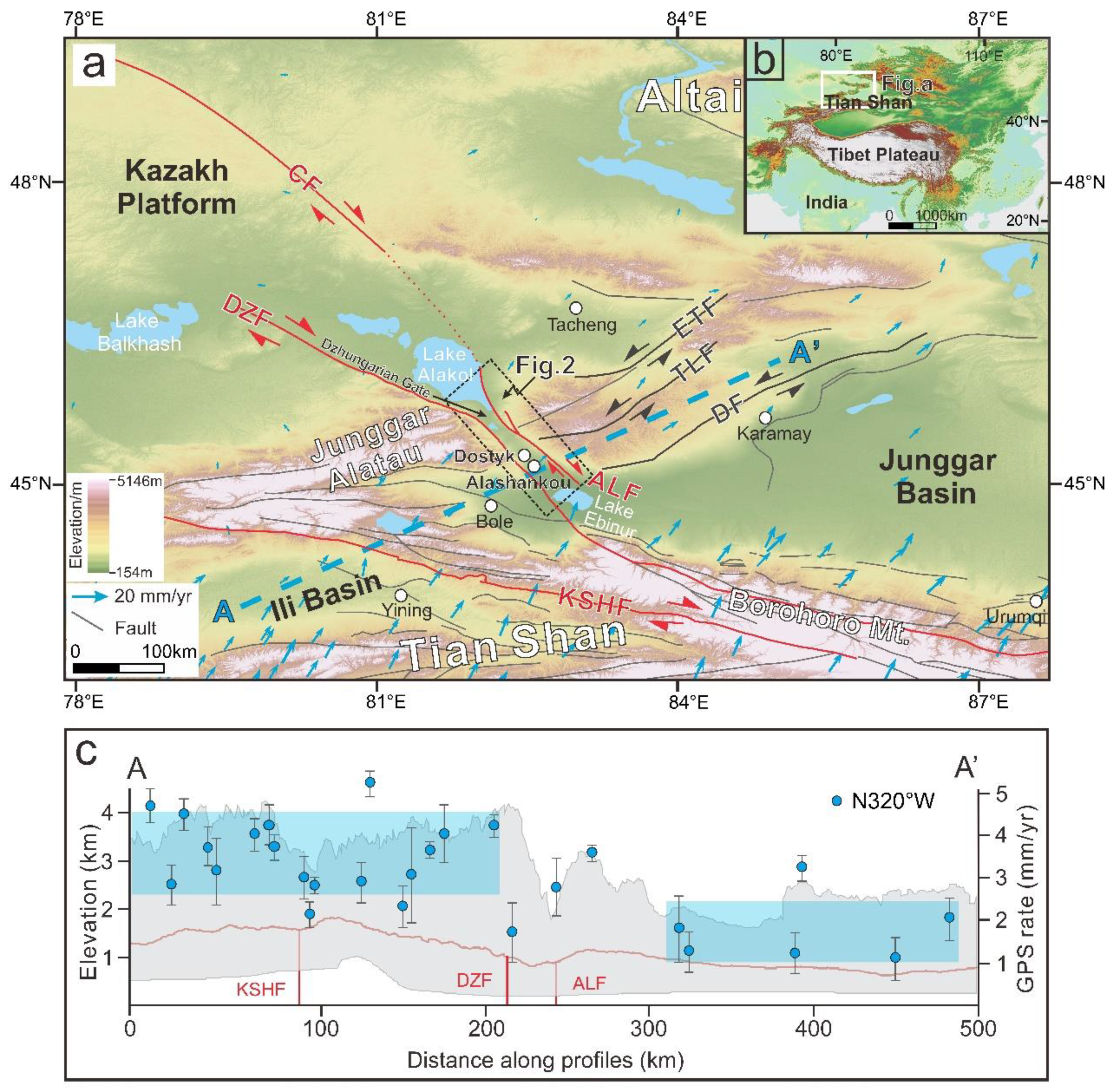
Figure 2.
The extension of the Alakol Lake fault is shown on Google Earth. The red dotted lines show the approximate location of the fault trace. The black boxes are the UAV and satellite image viewing areas. The white dotted line is the national boundary between China and Kazakhstan. The white circles show the major cities.
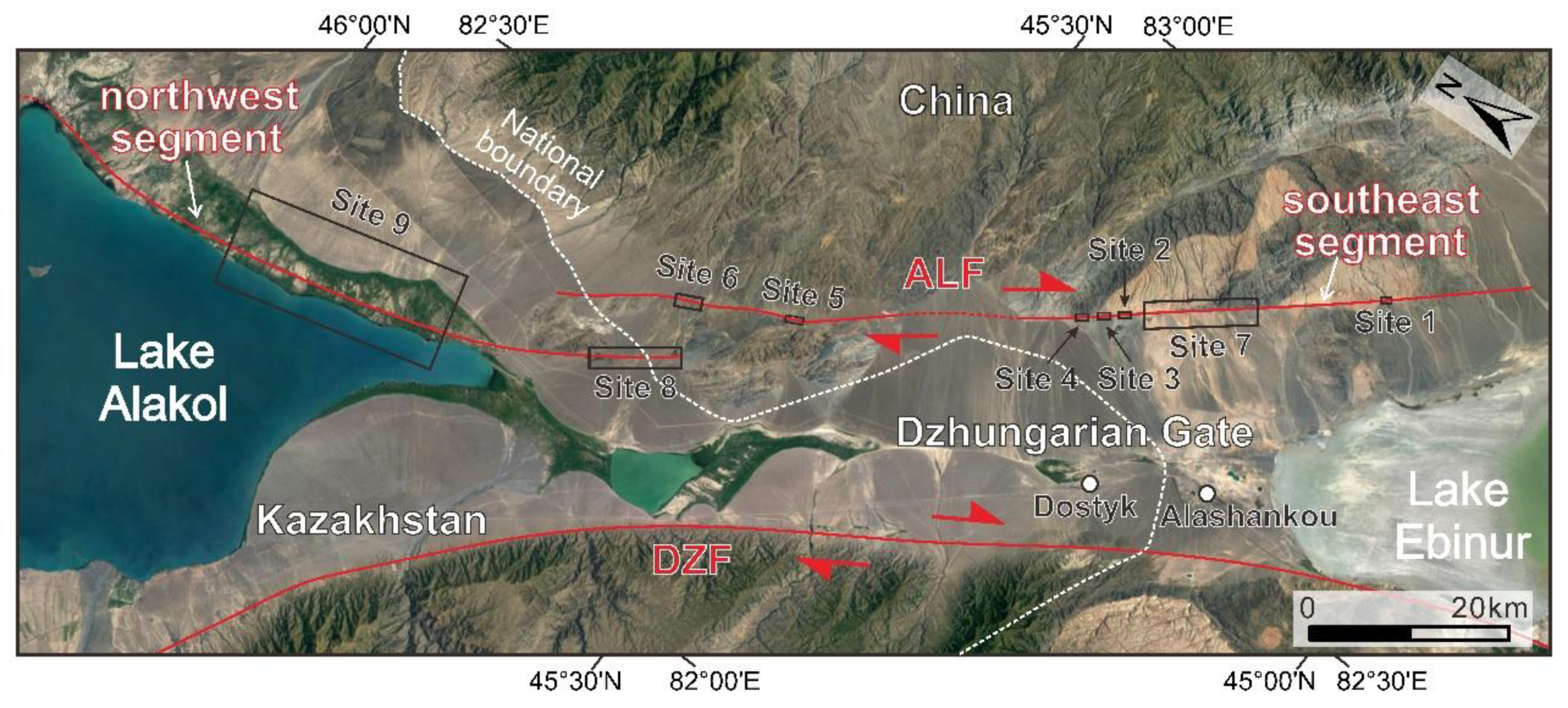
Figure 3.
Site 1: (a) The hillshade map, which is built from high-resolution UAV DEM by using ArcGIS, shows structural and geomorphological characters of the Alakol Lake fault. The red lines are the fault trace, and the scales indicate the slope direction of the fault scarp. The red dotted lines show that the fault traces are either unclear or covered. The black solid line (A-A’) marks the location of the extracted fault scarp. Four stages of alluvial fans (T1-T4) are developed along the stream channel, and the shadows with different colors depict the corresponding alluvial fans. The white dashed lines and the pink dashed lines represent the fit lines; (b) The image of the hillshade map displays an enlarged view of the geomorphic surface in Figure a. The blue and pink dashed lines in the image represent the fit lines; (c) Topographic profile across the fault extracted from the UAV DEM was used to measure the vertical offset. The blue dashed lines are fit lines; (d) The field photo shows the fault trace and alluvial fans, with Q representing the Quaternary deposits, N representing the Neogene sandstone, and C representing the Carboniferous granite. The white oval represents the white house as the reference; (e) The field photo was shot in the northwest. The red dashed line represents the covered fault trace. The fault scarp is marked with a red arrow. Q represents the Quaternary deposits, N represents the Neogene sandstone, and C represents the Carboniferous granite.
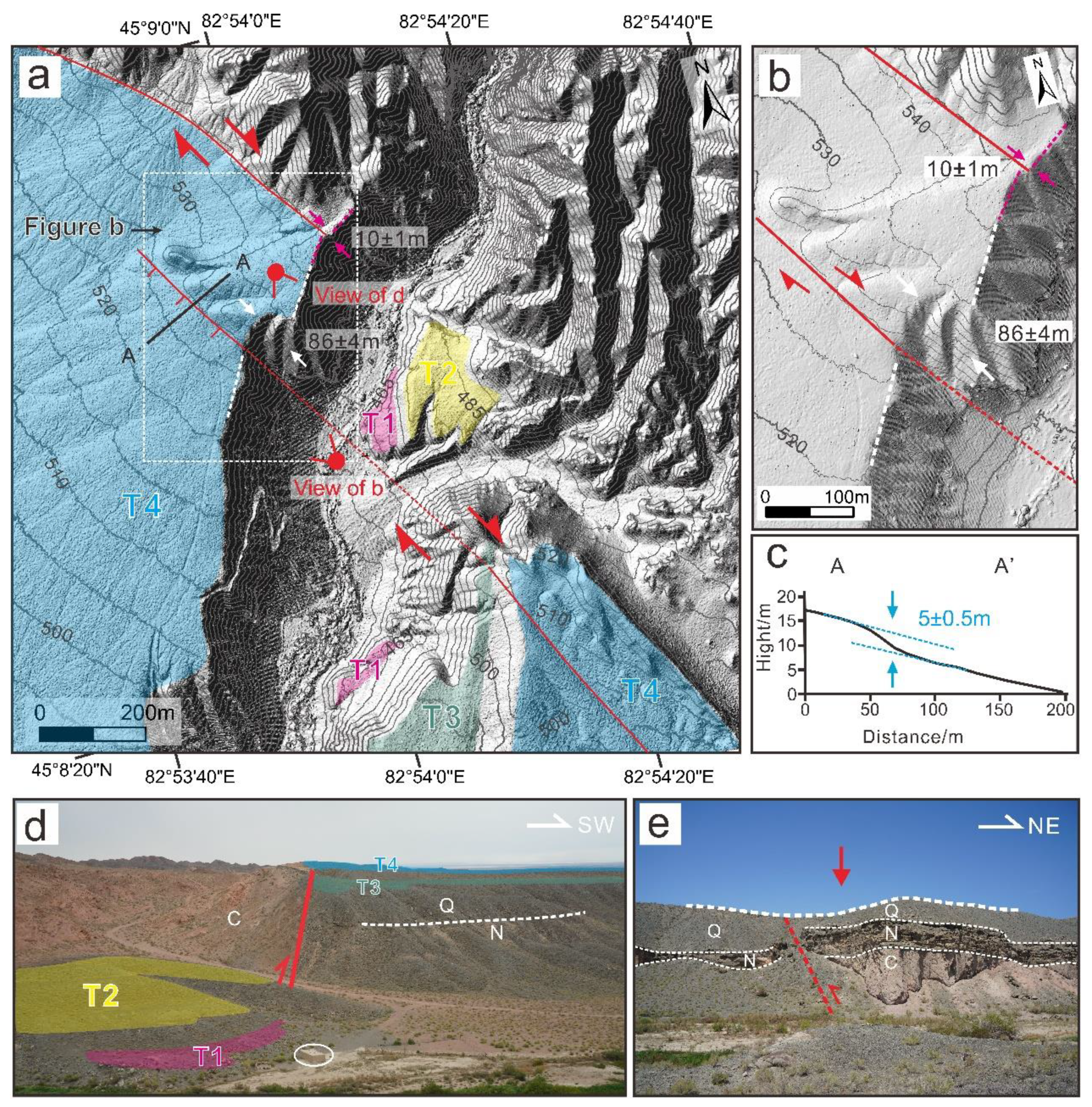
Figure 4.
Site 2: (a) The hillshade map image which is made by the high-resolution UAV DEM shows geomorphological expression of the Alakol Lake fault. The red lines are the fault trace, and the scales indicate the slope direction of the fault scarp. Two green curves represent the dextrally displaced alluvial fans. The orange curve represents the dextrally displaced ridge. The black solid line (A-A’ and B-B’) indicates the location of the extracted fault scarp. All of the black dashed lines represent the fit lines; (b) Two topographic profiles across the fault extracted from the UAV DEM were used to measure the vertical offset. The blue dashed lines are fit lines; (c) The field photo shows the dextrally displaced ridge. The dotted white lines show the location of the ridge. The red triangular arrows indicate fault trace. The blue dashed line indicates the dextral channel. The white ovals represent the people as the reference.
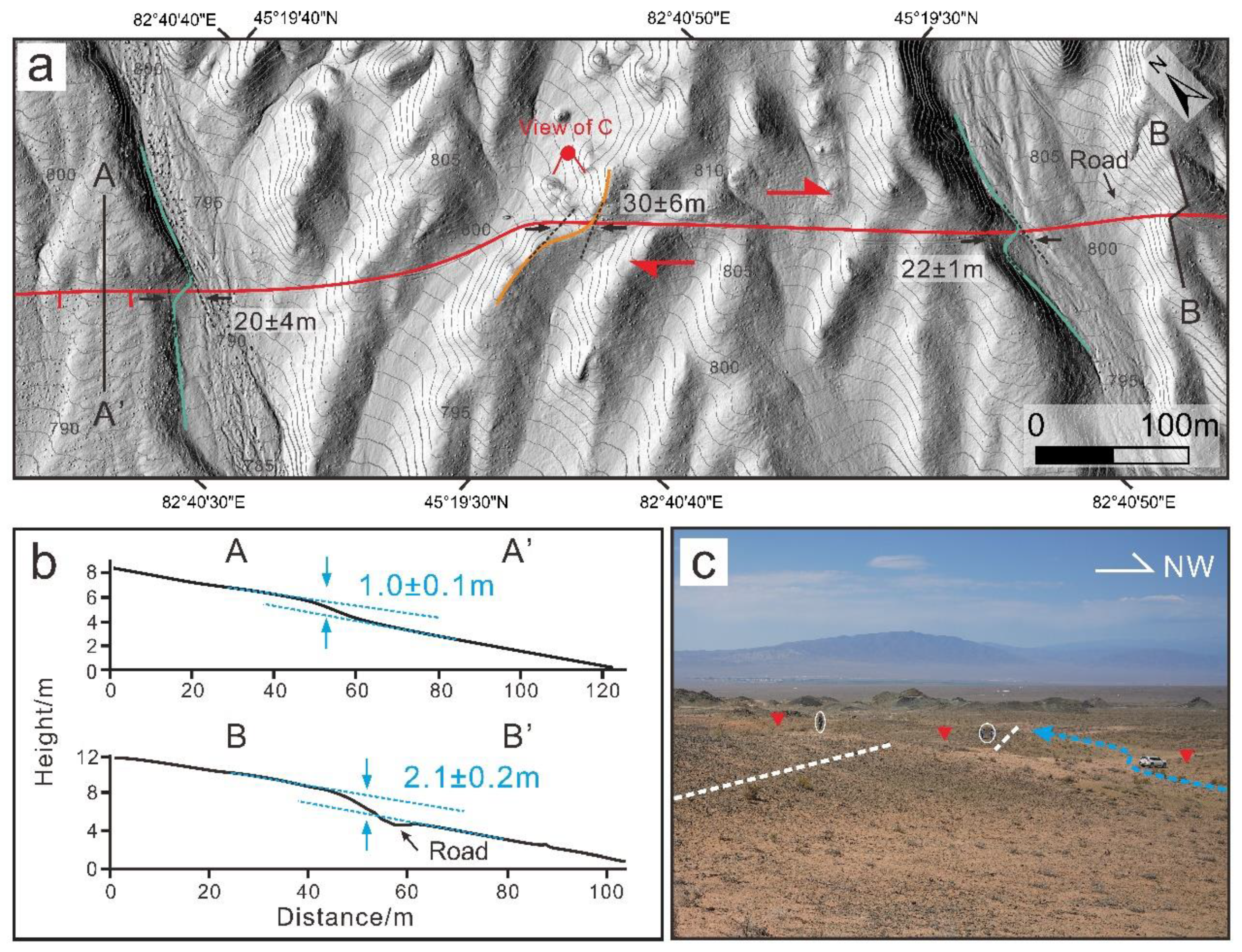
Figure 5.
Site 3: (a) The hillshade map image which is made by the high-resolution UAV DEM shows the geomorphological expression of the Alakol Lake fault. The red lines are the fault trace, and the scales indicate the slope direction of the fault scarp. Dark blue shadows represent fan 1, light blue shadow represents fan 2, and green shadow represents fan 3. The blue curves represent the dextrally displaced edge of the alluvial fans, and the white dashed lines represent the fit lines. The black solid lines (A-A’, B-B’, C-C’) indicate the location of the extracted fault scarps; (b) Topographic profiles across the fault extracted from the UAV DEM were used to measure the vertical offset. The blue dashed lines are fit lines; (c) and (d) The field photos show the fault trace and the pull-apart basin. The red triangular arrows and white dashed lines indicate fault trace. The black arrows indicate the fault scarp.
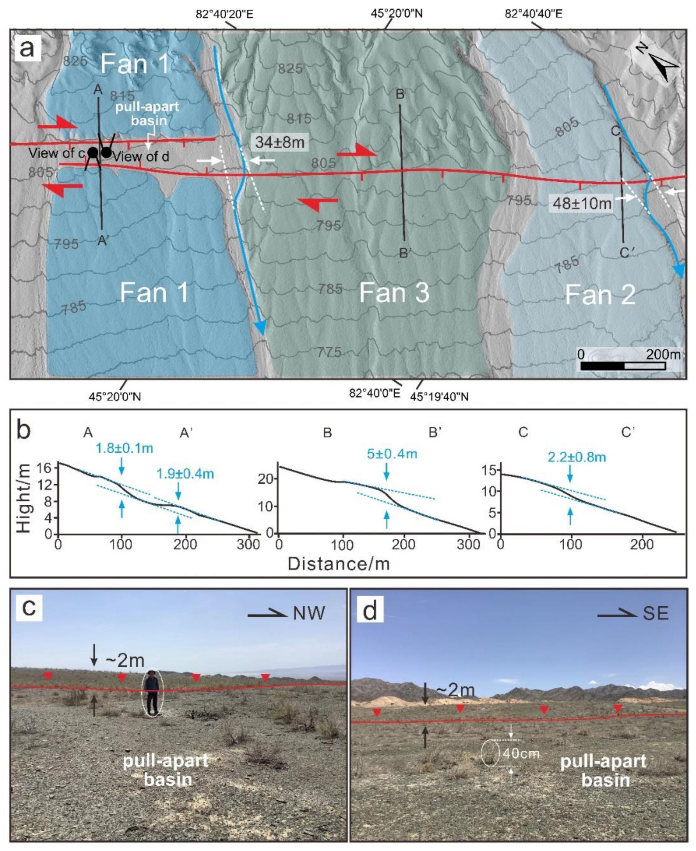
Figure 6.
Site 4: (a) The hillshade map image which is made by the high-resolution UAV DEM shows the geomorphological expression of the Alakol Lake fault. The red line is the fault trace, and the scales indicate the slope direction of the fault scarp. The blue curves represent the dextrally displaced gullies, and the white dashed lines represent the fit lines. The spring symbol composed of the blue circle and blue curve indicates the location of the fault spring. The black solid lines (A-A’, B-B’) indicate the location of the extracted fault scarps; (b) Topographic profiles across the fault extracted from the UAV DEM were used to measure the vertical offset. The blue dashed lines are fit lines; (c) The field photo shows the dextrally displaced gully and fault scarp; (d) The field photo shows the fault scarp. The dotted white line indicates the geomorphic surface. The red arrows show the fault scarp and fault trace; (e) The picture shows the fault spring in the field. .
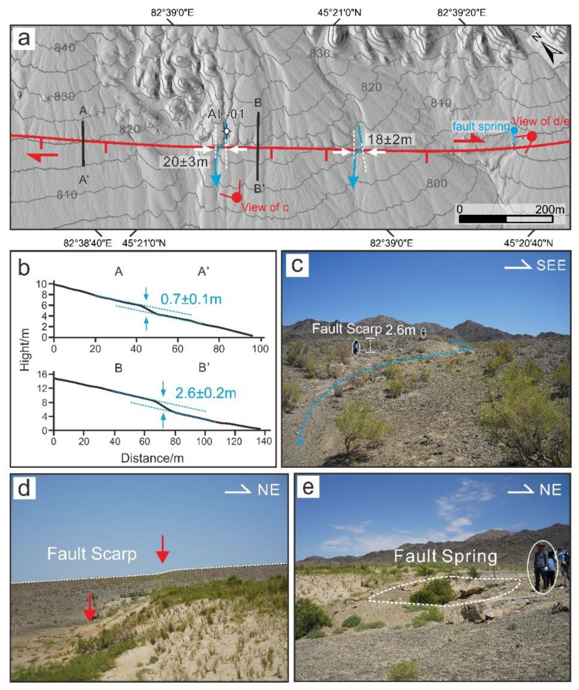
Figure 7.
Site 5: (a) The hillshade map image which is made by the high-resolution UAV DEM shows geomorphological expression of the Alakol Lake fault. The red lines indicate clear fault traces, while the red dotted lines show fault traces that are either not visible or are covered. The scales indicate the slope direction of the fault scarp. The blue curve represents the dextrally displaced stream channel. The green curve represents the dextrally displaced alluvial fan. All the white dashed lines represent the fit lines. The black solid lines (A-A’, B-B’, C-C’) indicate the location of the extracted fault scarps; (b) Topographic profiles across the fault extracted from the UAV DEM were used to measure the vertical offset. The blue dashed lines are fit lines; (c) The field photo shows the fault trace and the different alluvial fans. The red arrows indicate the fault scarp and fault trace, and the white circle represents the iron tower as the reference.
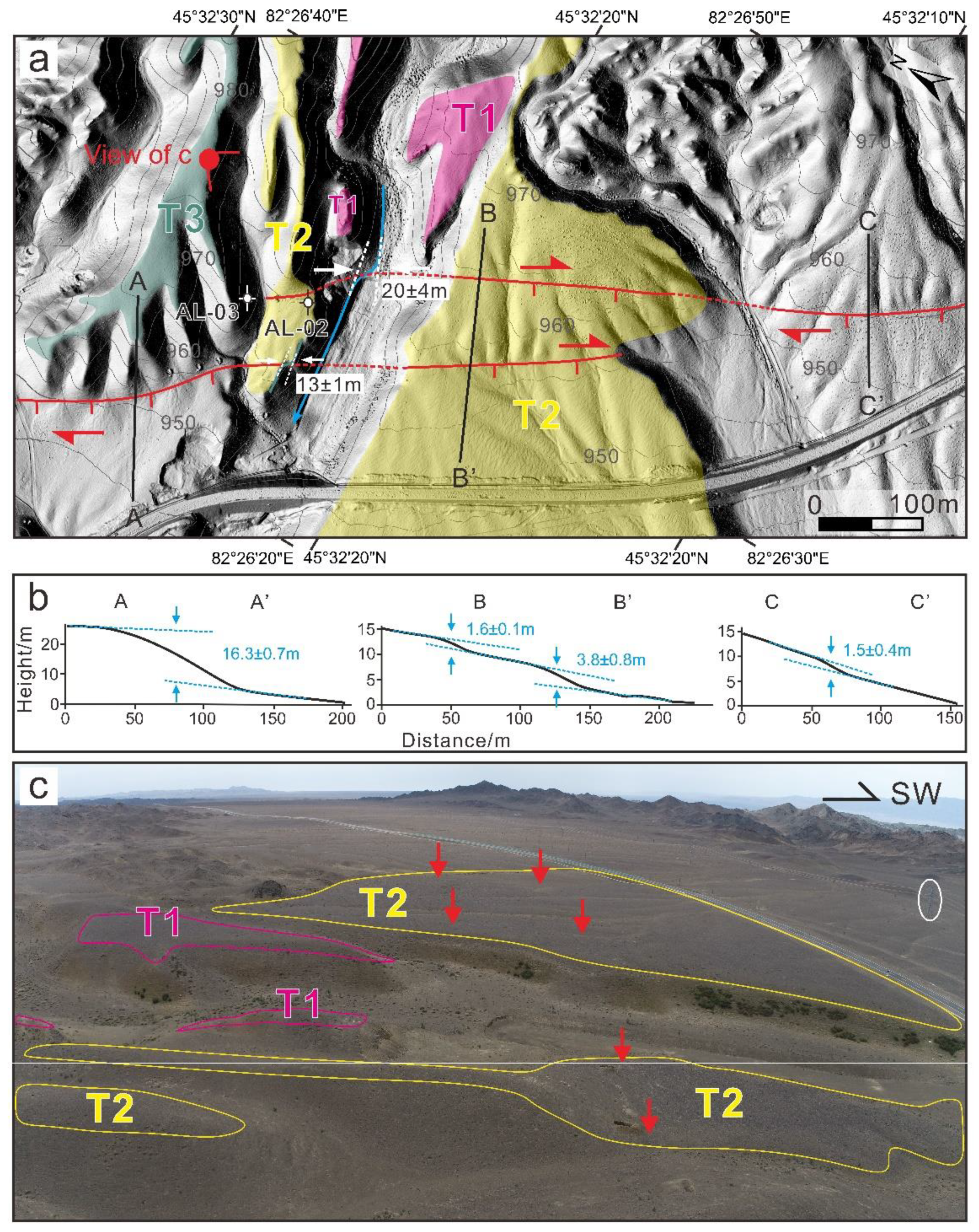
Figure 8.
Site 6: (a) View of the Pleiades DEM shows the geomorphological expression of the Alakol Lake fault; (b) Hillshade map image which is made by the high-resolution UAV DEM shows the enlarged geomorphic surface. The red lines are the fault traces, and the red dotted lines show the fault traces are not clear or are covered. The scales indicate the slope direction of the fault scarp. The translucent pink shade represents the range of T1, the translucent yellow shade represents the range of T2 and the translucent green shade represents the range of T3. The green curve represents the dextrally displaced alluvial fan. The blue curve represents the dextrally displaced gullies. All of the white dashed lines represent the fit lines; (c) The bedrock fault revealed in the field; (d) The locally amplifying bedrock fault.
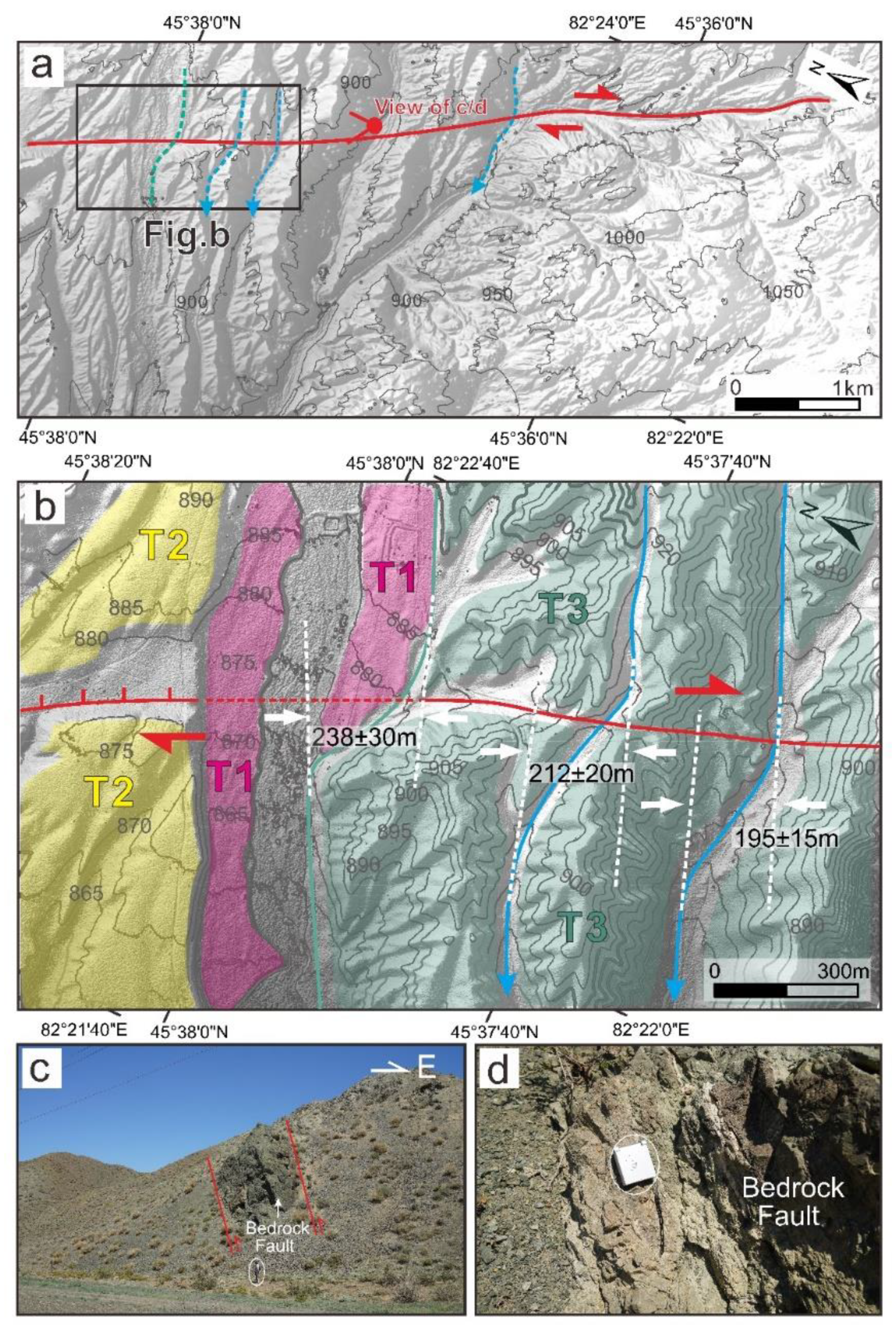
Figure 9.
Site 7: (a) View of the Pleiades DEM shows some displaced alluvial fans. The translucent green shades are the alluvial fans. The blue curves represent the stream channels and the axes of alluvial fans; (b) Hillshade map image which is made by the high-resolution UAV DEM shows the geomorphic surface of the enlarged alluvial fan 2.
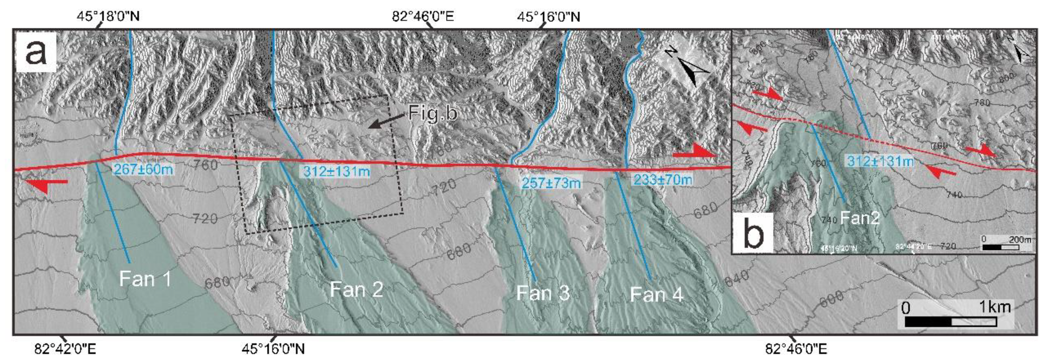
Figure 10.
Site 8: (a) View of the Pleiades DEM shows the fault trace and the displaced geomorphic surface. The red arrows indicate the fault trace. The blue dashed lines indicate the displaced gullies; (b) View of the enlarged geomorphic surface shows the displaced gullies; (c) The back-slipped view of the gullies.
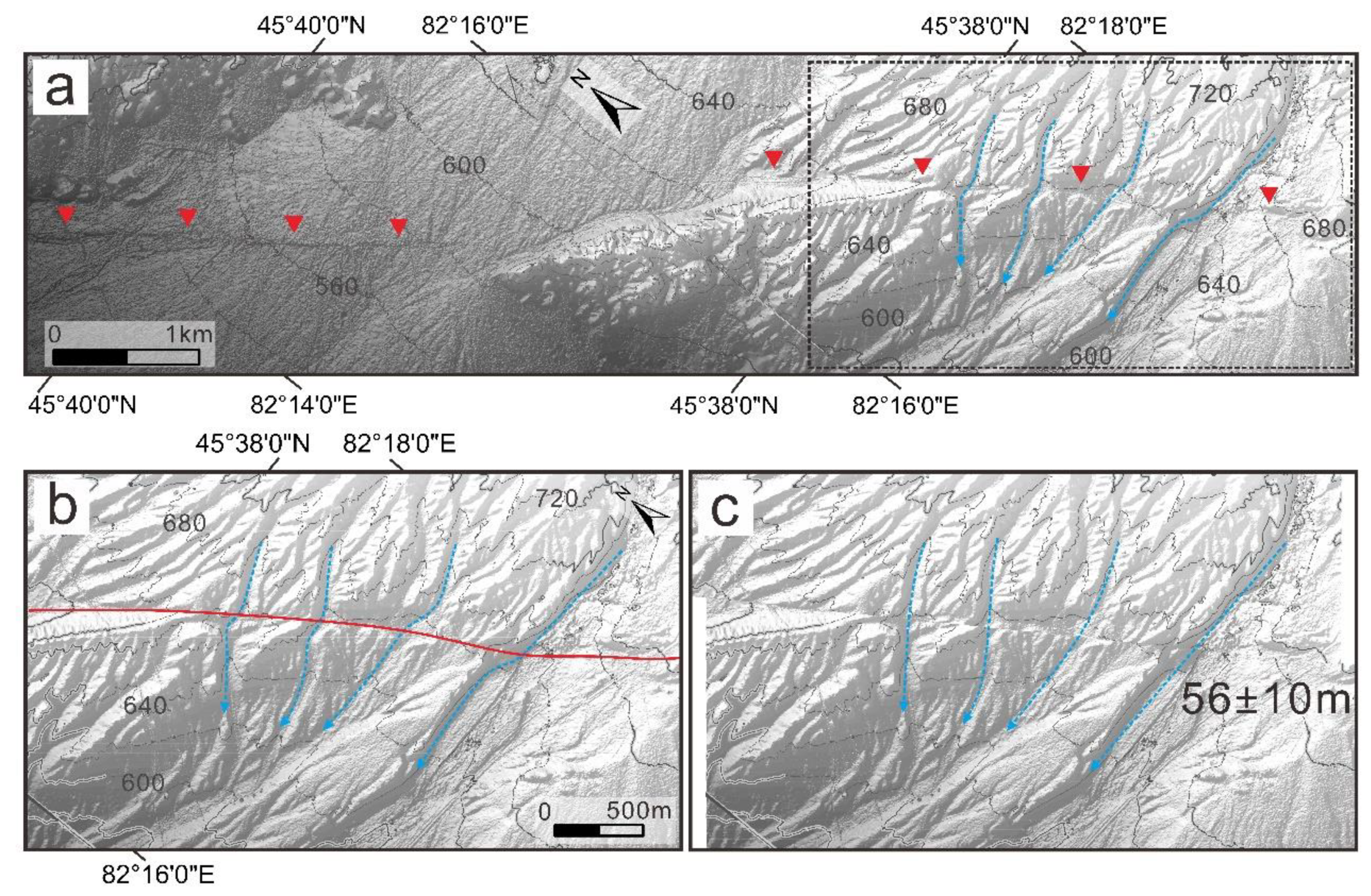
Figure 11.
Site 9: (a) The location of site 9 is shown on Google Earth; (b) The fault trace and geomorphic surface are shown on Google Earth. The red arrows indicate the fault trace. The black solid lines (A-A’ and B-B’) show where the topographic profiles were extracted. The white boxes represent the viewing areas of Figures d and e; (c) Topographic profiles (A-A’ and B-B’) across the fault extracted from DEM were used to measure the vertical offset. The blue dashed lines are fit lines; (d) and (e) Some images of the displaced gullies taken on Google Earth. The blue dashed lines indicate the displaced gullies. The white dashed lines represent the fit lines.
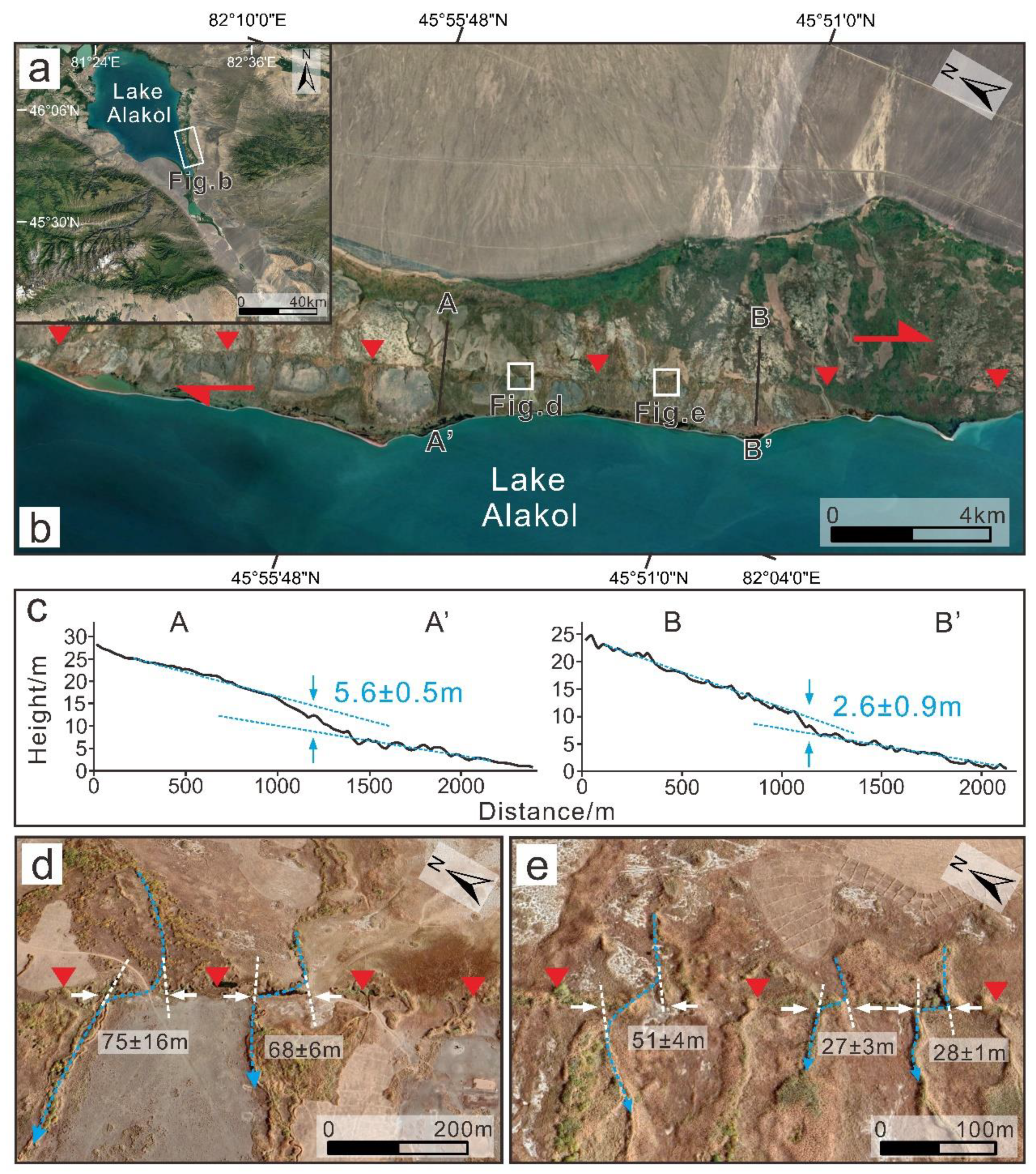
Figure 12.
Field collection locations of the OSL samples: (a) Sample AL-01; (b) Sample AL-02; (c) Sample AL-03; (d) Sample AL-04; (e) The field site shows a dextral alluvial fan and the fault scarp, which is also where the sample AL-04 was collected; (f) Sample AL-05; (g) The field site indicates the fault trace and fault scarp, which is also where the sample AL-05 was collected.
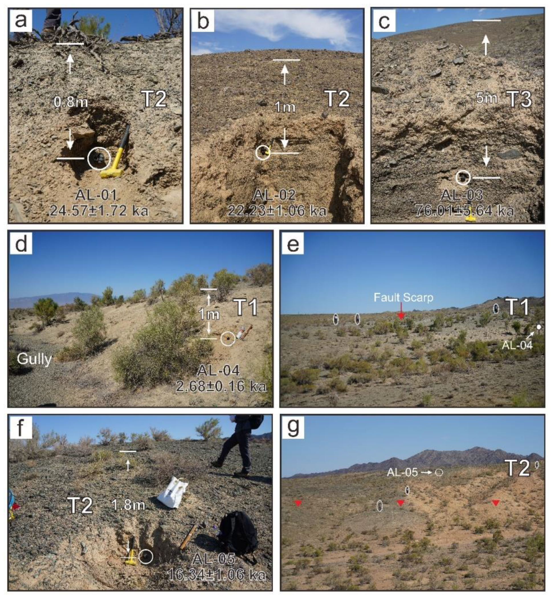
Figure 13.
(a) Simplified geological model map of the new fault in western Junggar. The white arrows indicate the relative moving direction of the Tacheng Basin, Junggar Alatau, and Junggar Basin. DZF—Dzhungarian fault; ALF—Alakol Lake fault; CF—Chingiz fault; KSHF— Kashihe fault; DF—Daerbute fault; TLF—TuoLi fault; ETF— East Tacheng fault; NTF—North Tacheng fault; (b) Evolutionary model map of the Lake Alakol and Alakol Lake fault.
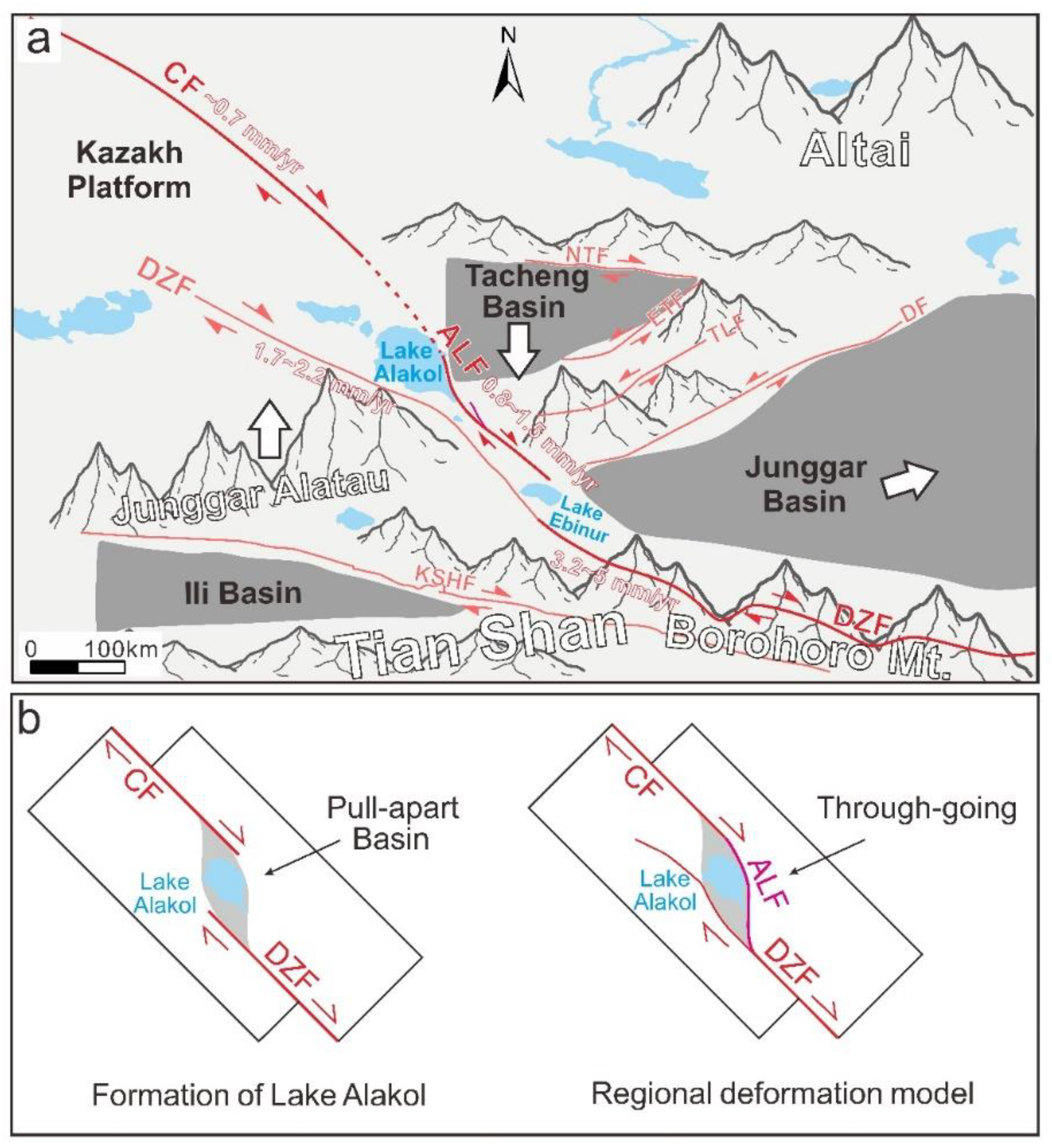

Table 1.
OSL Dating Results.
| Sample ID | Sample coordinate | Depth (m) |
U (ppm) |
Th (ppm) |
K (%) |
Water content (%) | D (Gy/ka) |
DeMAM (Gy) |
AgeMAM (ka) |
DeCAM (Gy) |
AgeCAM (ka) |
DeAVG (Gy) |
AgeAVG (ka) |
|---|---|---|---|---|---|---|---|---|---|---|---|---|---|
| AL-01 | 45°21′01″N 82°38′56″E |
0.8 | 2.12±0.01 | 6.57±0.08 | 1.69±0.01 | 5 | 2.73±0.11 | 39.7±3.15 | 14.57±1.3 | 64.24±3.91 | 23.57±1.72 | 66.96±3.81 | 24.57±1.72 |
| AL-02 | 45°32′24″N 82°26′29″E |
1 | 1.55±0.04 | 4.6±0.11 | 1.59±0.01 | 5 | 2.37±0.1 | 49.53±2.59 | 20.88±1.39 | 52.62±1.23 | 22.18±1.05 | 52.74±1.27 | 22.23±1.06 |
| AL-03 | 45°32′25″N 82°26′28″E |
5 | 1.59±0.03 | 4.5±0.05 | 1.35±0.01 | 5 | 2.05±0.09 | 155.45±9.57 | 76.01±5.64 | 196.36±7.61 | 96.02±5.45 | 199.3±7.09 | 97.46±5.32 |
| AL-04 | 45°21′38″N 82°38′21″E |
1 | 1.69±0.03 | 7.28±0.05 | 1.89±0.01 | 3 | 2.94±0.12 | 5.65±0.39 | 1.92±0.16 | 7.7±0.33 | 2.62±0.16 | 7.87±0.35 | 2.68±0.16 |
| AL-05 | 45°19′07″N 82°41′39″E |
1.8 | 2.08±0.04 | 9.45±0.11 | 3.15±0.01 | 5 | 4.26±0.18 | 52.48±4.6 | 12.31±1.2 | 68.43±3.43 | 16.05±1.05 | 69.67±3.43 | 16.34±1.06 |
Note: OSL, optically stimulated luminescence; D is the environmental dose rate; DeMAM is the equivalent dose calculated by the minimum age model; DeCAM is the equivalent dose calculated by the median age model; DeAVG is the equivalent dose calculated by the average age model; AgeMAM is the optical luminescence age calculated by the minimum age model; AgeCAM is the optical luminescence age calculated by the median age model; AgeAVG is the optical luminescence age calculated by the average age model.
Disclaimer/Publisher’s Note: The statements, opinions and data contained in all publications are solely those of the individual author(s) and contributor(s) and not of MDPI and/or the editor(s). MDPI and/or the editor(s) disclaim responsibility for any injury to people or property resulting from any ideas, methods, instructions or products referred to in the content. |
© 2024 by the authors. Licensee MDPI, Basel, Switzerland. This article is an open access article distributed under the terms and conditions of the Creative Commons Attribution (CC BY) license (https://creativecommons.org/licenses/by/4.0/).
Copyright: This open access article is published under a Creative Commons CC BY 4.0 license, which permit the free download, distribution, and reuse, provided that the author and preprint are cited in any reuse.


