
Submitted:
27 June 2024
Posted:
01 July 2024
You are already at the latest version
Abstract
This study analyzed the dynamic spatial and temporal distribution of natural disasters in Traditional Authorities Ngabu and Lundu in Chikwawa District in the Lower Shire Valley. The study assessed the vulnerability of people to disasters, evaluated the value of losses and damages incurred when disasters strike and to locate disaster hotspots. The mixed design that embraces qualitative and quantitative approaches was used. Data collection methods such as in-depth interviews, Focus Group Discussion, documentary review, structured interview and Participatory Geographical Information Systems (P-GIS) were employed. The study revealed that farming with 64%, 37% and 76% done before, during and after disasters respectively, was the main adaptive capacity to floods and drought in T/A Ngabu. In T/A Lundu, community members also valued farming with 58%, 55% and 70% done before, during and after disasters respectively. The study found that Traditional Environmental Knowledge Systems (TEKS) were highly valued in T/As Ngabu with 90% and Lundu 81%. The study also unveiled those disasters led to losses of human lives and livestock and damages to properties, environment and critical infrastructures. However, some community members still remained in the disaster-prone areas for farming, fishing, protecting the chieftaincy and ancestral reasons. The study also showed that CBDRM was highly adopted. However, disasters continued to occur and losses were increasing. Generally, CBDRM could be effective through multisectoral approach and good legal institutional framework. Therefore, the research recommends that further studies similar to this, should use GIS in assessing the efficacy of CBDRM approaches to produce hazard maps that will be used as models for disaster risk reduction in Chikwawa District in the Lower Shire Valley.
Keywords:
Disasters
; Hazard
; GIS
; Resilience
; Capacity
Introduction
Geographic Information Systems (GIS) is a conceptualized framework that provides the ability to capture and analyze spatial and geographic data. It has since been rising globally, regionally and locally. Since the ‘80s, the interest for Geographic Information Systems (GIS) has been rising both in the private and the no-profit/humanitarian sectors, as a tool to monitor land use changes, rivers patterns, and evolution of disaster risk (UNISDR, 2015). The great advantage of GIS is the possibility to merge different information from several sources and visualize them on a unique map thanks to a georeferencing process (ESRI, 1990).
In recent years, Geographical Information Systems (GIS)-based spatial statistical analyses in disaster risk management studies have increased across the globe. To this effect, it was imperative to examine the spatial distribution of natural disasters to prevent and mitigate disasters. In this light, natural disasters that happened between 1990 and 2020 have been examined. The study employed mixed research design that embraces both qualitative and quantitative approaches where autocorrelation and Participatory Geographical Information Systems (P-GIS) methods to data collection were used. Later on, GIS models for visualization were produced for better community-based disaster response.
Research Methodology
Qualitative and quantitative research methods were employed. Qualitative methods were used to elicit people’s perception and knowledge of risk and their adaptation responses to disasters. Participatory GIS was used to locate areas that are prone to floods, droughts, inundated areas, identify streams that jump their beds to cause floods, locate social services, areas for cultivation, areas for grazing animals and safer areas in cases of floods. Quantitative methods were used to assess the vulnerability of people, determine the development activities adversely affected by disasters and assess reasons why people still remained the disaster-prone areas. Sampling techniques and modification-detection techniques were employed to select local people and to identify shire valley environmental change.
Data analysis:
The data was analyzed by using ArcGIS, ArcView and QGIS, manual analysis of qualitative data and GIS and remote sensing for image analysis. The data has been presented in term of words, Figures such as Maps, charts, graphs and tables.
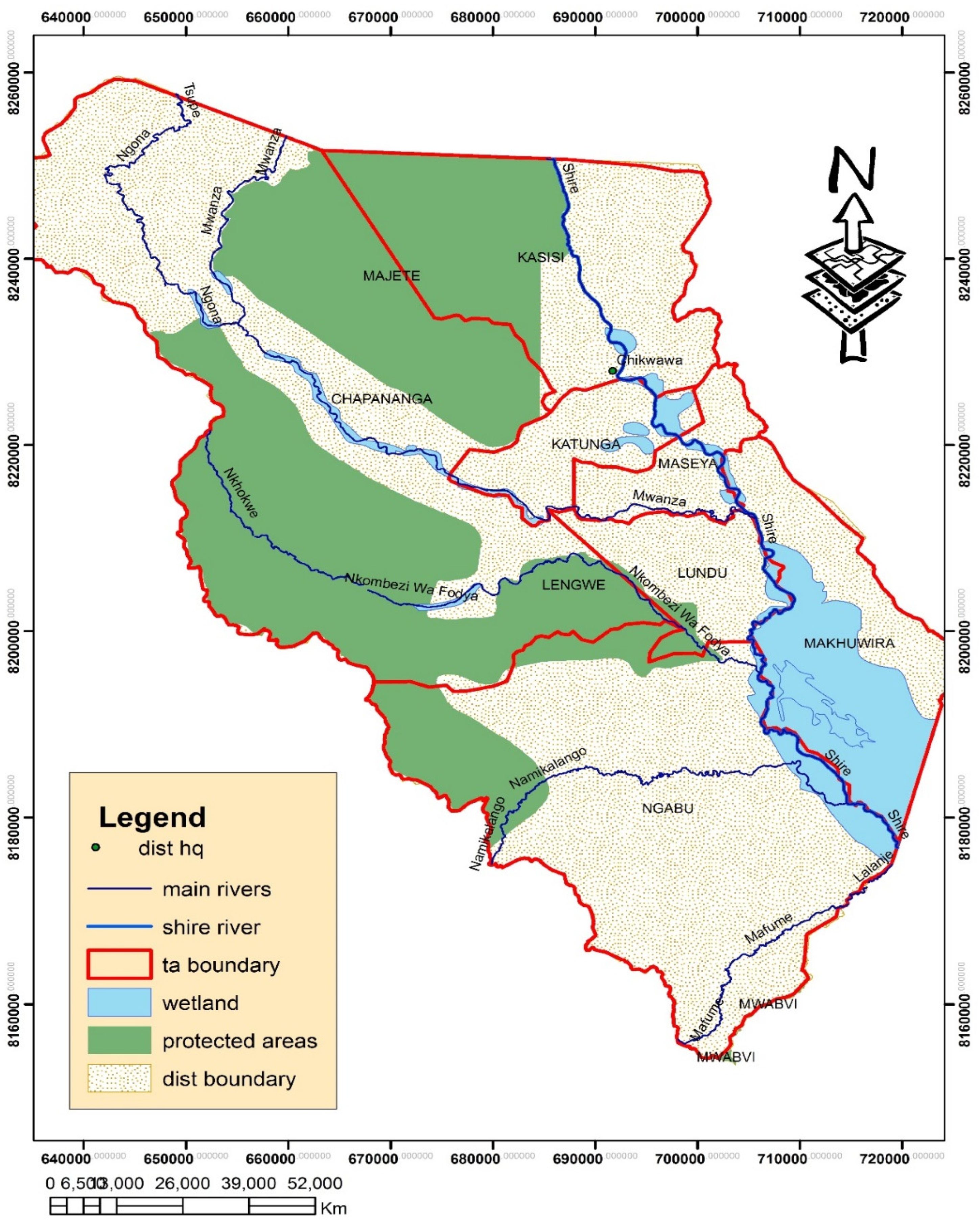
Study Site:
Lower Shire Valley is formed by two districts namely Chikwawa and Nsanje where Chikwawa lies to the north and Nsanje to the south. Lower Shire Valley is located between 160 101.00 S and longitude 350 451.00E (New Horizon Social Environmental Sciences, 2014). Chikwawa District where the study was conducted is 4,755 km2 (NSO, 2018). Chikwawa District is bordered by Mozambique to the west and north is Blantyre District and Thyolo District to the east. To the Northwest of Chikwawa District is also Majete Game Reserve and Central West is Lengwe National Park (New Horizon Social Environmental Sciences, 2014).
Figure 1.
Map of Chikwawa, Source: Authors, September, 2018.
FINDINGS AND DISCUSSION
Vulnerability Assessment of the Communities in T/As Ngabu and Lundu in the Lower Shire Valley
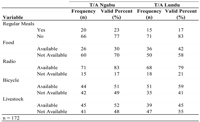
The results revealed that 77% and 83% of the population in T/As Ngabu and Lundu respectively, had no regular meals. In the area of T/A Ngabu, 60% of the population had no food while 58% of the population in T/A Lundu, had no food as well. The study found that 83% of the population in T/A Ngabu had radios while in T/A Lundu, 79% had also radios. The study found that 51% and 59% of the population in both T/As Ngabu and Lundu respectively, had bicycles. the study revealed that in T/A Ngabu 52% of the population had livestock while 45% of the population in T/A Lundu had livestock (Table 1).
Based on the results, it showed that people in the areas of T/As Ngabu and Lundu had no regular meals with 77% and 83% respectively. The study also revealed that in both T/As Ngabu and Lundu, food was not available (70% and 58%). This implies that community members in both T/As Ngabu and Lundu starved to access food. It was revealed that those who were able to have regular meals were employed. This gives an account that economic status of an individual defines one’s own vulnerability. This is also similar to what Thinda (2002) found in Zambia. The study revealed that most of the community members had one meal per day especially the none-working class.
The study findings showed that community members in both T/As had radios. However, many were from T/A Ngabu (83%). The study also revealed that community members liked listening to various programmes such as “ulimi walero” (today’s agriculture) and other weather-related programmes that brought about warnings to disasters. This implies that people were interested to listen to radios as they noticed that they were vulnerable to disasters. This is a good development because personal mitigation is a key to national disaster preparedness and planning. This is also similar to what Mung’ou (2009) found in Kenya. The study aimed at assessing the contribution of ICT in disaster management. It was found that radios were important in information dissemination and awareness. This helped to reduce disaster impacts in Kenya as many people had radios.
The study also found that bicycles were available with 51% and 59% in both T/As Ngabu and Lundu. On average however, the study revealed that not all had bicycles as 55% in both T/As was not a significant number as compared to the population. It was revealed that bicycles were convenient as they provided the communities with cheap means of transport. During emergencies, it became handy to respond to. This is also similar to what Page (2014) found in Northwest Pacific. The study revealed that communities were using cargo bicycles as they were effective in times of fuel and gas shortages. In a more generic sense, bicycles were very important to the communities of T/As Ngabu and Lundu as most of the roads were impassable. Therefore, bicycles played a big role to solve transportation problems.
Based on the results, the study revealed that in T/A Ngabu, 52% of the population had livestock while 45% of the population in T/A Lundu had no livestock. This implies that many community members did not have livestock in T/A Lundu (45%). It was found that livestock provided source of food, income, transportation and also for prediction of disasters. The study conducted by Tewari (2018) in India found similar results. It was found that animals were used to predict disasters through their behaviour.
The study also revealed that communities in T/As Ngabu and Lundu in Chikwawa District hardly accessed services such as health, education, transportation, electricity supply, sanitation, running water and community standing pipes. Most of the services were unreliable. For example, villages such as Chindoko, Linga, Therere and Nsomo in T/A Ngabu had no piped water, health services, electricity and had poor road network. In T/A Lundu, villages such as Bester, Mafale, Tizola and Sekeni had poor water and sanitation services, roads and health services.
Nature and Characteristics of Hazards in Chikwawa District
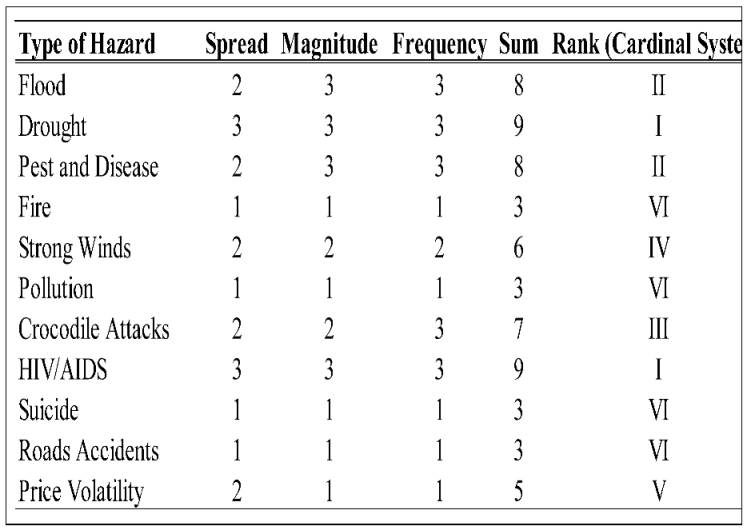
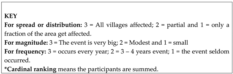
In attempt to understand the vulnerability of communities, it was imperative to examine the nature and characteristics of hazards that were prevalent in T/As Ngabu and Lundu. The study revealed that floods, drought, dry spells, strong winds, pest and diseases, HIV/AIDS, pollution, crocodile attacks, fire, suicide and road accidents and price volatility with varied frequency, spread and magnitude were common in T/As Ngabu and Lundu. TASAF (2010) and Rugumamu and Haule (2015) also conducted studies in Tanzania and found that drought, floods and dry spells with high frequency and magnitude affected communities in Tanzania. Therefore, this study sought to rank the disasters in both T/As Ngabu and Lundu in Chikwawa District in the Lower Shire Valley based on frequency, spread and magnitude.

Table 2.
Ranking Hazards.
|
Source: Field Data
The findings showed that drought and HIV/AIDS (I) were the most prevalent hazards in both Traditional Authorities of Ngabu and Lundu in Chikwawa District with high frequency, magnitude and were widely spread. Floods and pests and diseases with high frequency, magnitude and partial distribution respectively, were second (II). However, the study revealed that for the past three years, frequency of floods lowered and the magnitude remained high. This is also in line with what South Dakota Mitigation Plan Team (2014) found in Dakota. The study conducted by Bergmann and Samuels (2008) also found that globally HIV/AIDS was a major concern as it was spreading fast.
Crocodile attacks with moderate magnitude, partial distribution and high frequency were ranked third (III). The study found that the frequency and magnitude became high during floods since crocodiles moved with the water in search of food in Linga village in the area of Traditional Authority Ngabu. Similar study conducted by Grajavales and Silva (2018) found that crocodile attacks in Mexico particularly Oaxaca, were so alarming. In Mexico, crocodile attacks were associated with fishing where 92% of the victims were men. In the context of Malawi and T/As Ngabu and Lundu in Chikwawa District in particular, this disaster risk can be avoided if people desist from fishing in the Shire River and relocate permanently. Chavula (2012) also argues that permanent relocation in flood disaster prone areas is the best strategy.
Strong winds were ranked fourth (IV) as common hazards in both T/As in Chikwawa District. They occurred at a 3-4-year interval thus frequency, but with moderate magnitude and partial distribution. In contrast, the study conducted by South Dakota Mitigation Plan Team (2014) found that winds with high frequency, magnitude and wide distribution were common in Dakota. Although it is difficult to prevent winds from occurring but their effects can be reduced. This can be done by planting trees, building houses with strong materials and avoiding deforestation.
The study also revealed that price volatility with small magnitude and low frequency and partially distributed was fifth (V) in T/A Ngabu and Lundu in Chikwawa District. It was revealed that communities depended on white maize which did not do well in the district due to poor climatic conditions. The findings indicated that markets in Chikwawa District were competitive. Most of the maize came from Mulanje, Phalombe and Thyolo districts and prices were mostly high. The changes in prices affected communities’ way of life as most of the people depended on ‘ganyu’ known as casual labour. These results are also similar to what Mtembenuzeni and Kushe (2017) found in Chikwawa District particularly in Traditional Authority Makhuwira.
The results of the study also showed that pollution, fire, road and suicide accidents were ranked six (VI). It was revealed that these hazards were not widely spread and had low frequency and magnitude. In contrast, Vennemo et al. (2009) conducted a study in China and found that pollution was widely spread and had high frequency including magnitude in terms of impact. The study conducted by Coon (2017) found that suicide accidents were common in India. This study revealed that 800,000 people died of suicide accidents and this was a significant number. In the context of Malawi, particularly T/As Ngabu and Lundu, using public education and awareness, the suicide disasters can be prevented.
Singh and Misra (2001) also found that in India, road accidents fatality rate was high due to over speeding. It is therefore imperative to observe road safety rules. The study conducted by Murali and Vijayalaskshmi (2014) and Sundrama, Pradesh and Krishna (2016) also found that fire disasters were caused by electric faults and affected India and Bangladesh. Switching off electric appliances, monitoring young children when playing with fire and public education and awareness can best reduce occurrences of fire accidents.
Development Activities Adversely Affected by Disasters
The study found that 47% of the population in T/A Ngabu said that agricultural activities were affected while T/A Lundu was represented by 48%. Out of 86 respondents in T/A Ngabu, 5% said that road infrastructure was adversely affected. In T/A Lundu, 3% of the population also said that road infrastructure was affected. Respondents who said electricity supply was affected in T/A Ngabu were 3 representing 3% while T/A Lundu was represented by 3%. Only 37 respondents representing 43% said that building infrastructure was affected in T/A Ngabu while in T/A Lundu there were 36 respondents representing 42%. Out of 86 respondents in T/A Ngabu, only 2 representing 2% of the sample population said that disasters such as floods affected water supply. In T/A Lundu there were 3 respondents representing 3% of the population who said that water supply was adversely affected by disasters (Table 2)
Table 3.
Development Activities Adversely Affected by Disasters.
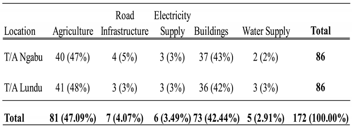
Source: Field Data
On average, the findings showed that disasters highly affected agricultural sector (47%) in both T/As Ngabu and Lundu in Chikwawa District. However, T/A Lundu was highly affected than Ngabu. The other developmental activity that was highly affected was building infrastructure in T/As Ngabu and Lundu with 43% and 42% respectively. However, T/A Ngabu was highly affected. Others were road infrastructure, electricity and water supplies. The study also revealed that floods, drought, dry spells, winds and pests and diseases, caused more damage to crops leading to hunger. The study unveiled that these disasters set back the development clock of Chikwawa District in the Lower Shire Valley hence increasing community vulnerability.
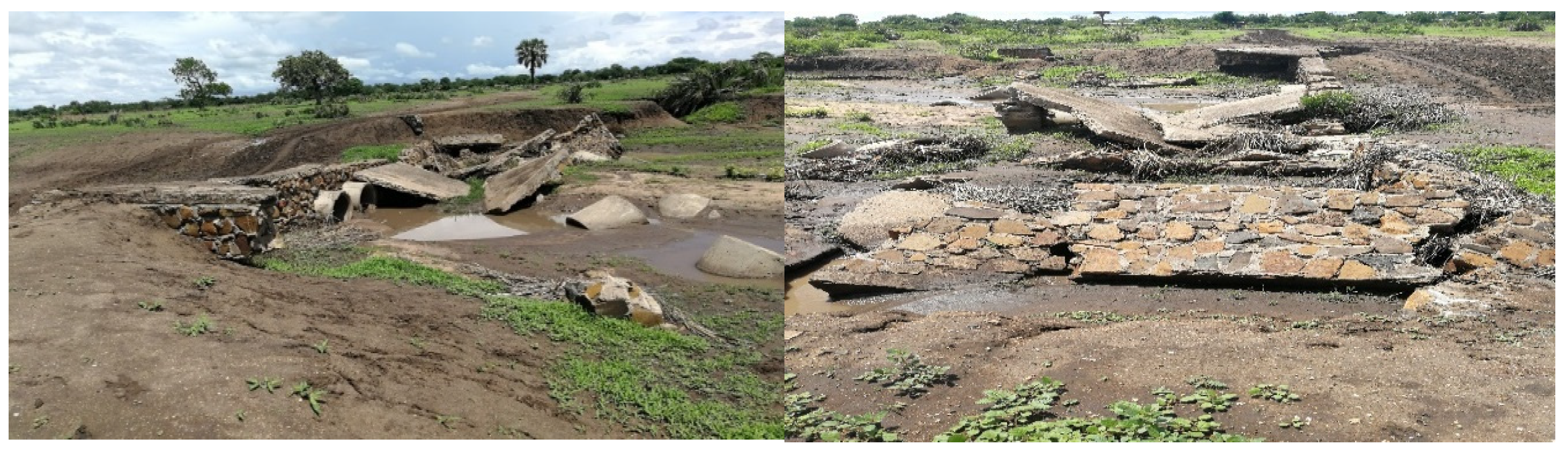
The study also unveiled that disasters such as floods brought problems of transportation and communication in both Traditional Authorities. This increased community’s vulnerability as community members could hardly access health services because roads and bridges were impassable (Plate 1).
Plate 1.
A Bridge Damaged by Floods at Chindoko Villagw, T/A Ngabu. Source: Photo Taken by Tobias (Author), November, 2018
Plate 1.
A Bridge Damaged by Floods at Chindoko Villagw, T/A Ngabu. Source: Photo Taken by Tobias (Author), November, 2018
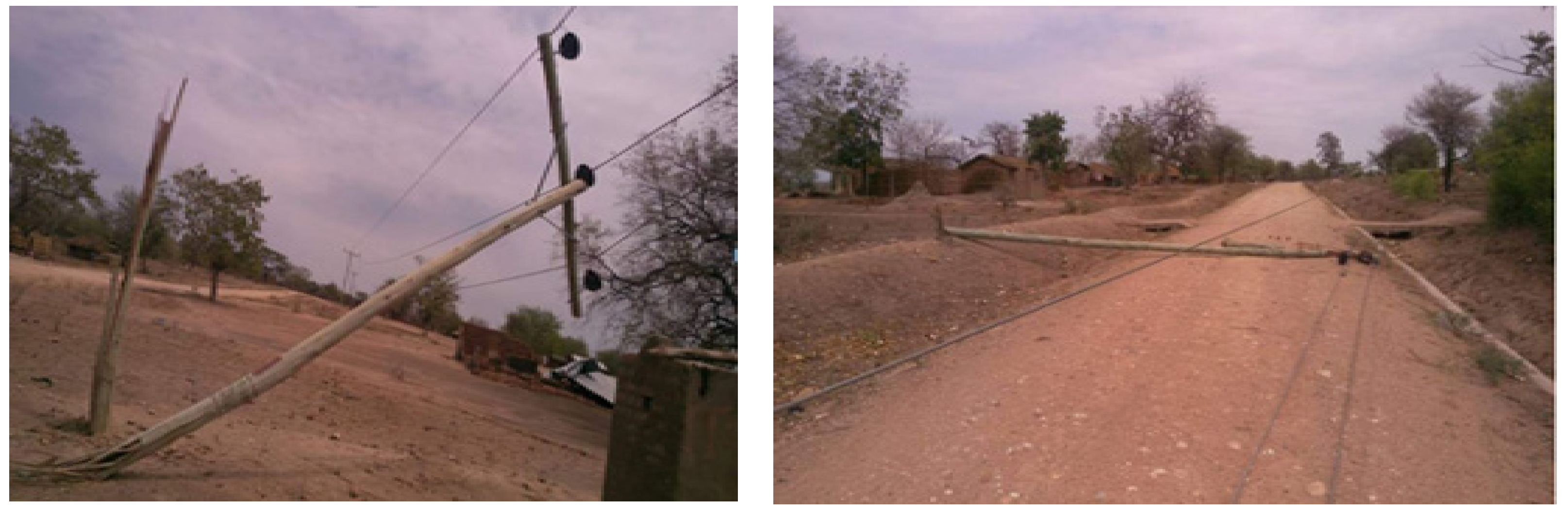
The study also found that electricity was affected by disasters such as strong winds, floods and drought. Winds caused electric poles to fall down (Plate 1). When the area was also flooded, most of the electric poles fell down affecting electricity supply. If electricity supply was affected, water supply was also affected in the district. Electricity was used to pump water from the ground. This implies that water supply depended on electricity hence compounding disasters.
Plate 2.
Electric Poles Damaged by Strong Winds in T/A Lundu. Source: Government (2018)
The study also unveiled that turbidity and debris in the Shire River during the rainy season affected hydro-power generation. These blocked the hydro-power plants. Drought also lowered the ground water table. This then affected both water and electricity supplies. However, the study revealed that the geographical location of Chikwawa District increased the vulnerability of the communities in T/As Ngabu and Lundu. This is also in line with what Wisner et al. (2005) contend in PAR model. Therefore, relocation can be a better strategy to reduce the losses incurred when disasters strike.
Rivers and Inundated Areas in T/A Ngabu in Chikwawa District
Through P-GIS the study revealed that Chimbamera, Nyakamba, and Nyakakupa caused floods in T/A Ngabu and the villages such as Nsomo and Chindoko were the inundated areas (Figure 2). The study also found that Chimbamera, Nyakamba and Nyakakupa rivers originated from the western part of Ngabu. These rivers passed through Nsomo, Malemia, Chindoko and Nyambiro in T/A Ngabu. It was also established that these rivers caused damages to properties, crop fields, roads, schools, bridges and health facilities. This is also similar to what Kienberger (2005) found in Mozambique using P-GIS. In this case, plans for development and the development projects taking place in the areas must be reversed. If need arises, all development actors must work together for better disaster response.
Areas Under Cultivation in Traditional Authority Ngabu in Chikwawa District
The study also sought to locate areas under cultivation and for grazing in T/ A Ngabu. The study revealed that Nsomo and Chindoko were suitable for cultivation and also part of Malemia (Figure 3). However, these were inundated areas. The area suitable for grazing animals was Northwest of Ngabu. Based on the results, the study showed that communities in T/A Ngabu were vulnerable as they did not have a better place to live. Through P-GIS, the study found that Ngabu was at an altitude between 50-100 metres above sea level. This implies that the area was relatively flat where the likelihood of floods occurrence coupled with numerous rivers was high. Based on this, it can be concluded that the geographical location increased community vulnerability. This is in line with what Letsei (2015) found in Lesotho. However, the study found that 70% of the population lived in ecologically fragile mountainous terrain.
Distribution of Social Services in T/A Ngabu
Using P-GIS, the study showed the distribution of social services in Traditional Authority Ngabu. Some of the social services that were identified were health, education and water supply. The study revealed that these were unevenly distributed and others were located in inundated areas (Figure 4). The uneven distribution of social services increased the vulnerability of communities. The study also found that political will was the main cause. This is also in line with PAR model (Blaikie et al. 1994). This model holds that political systems can contribute to community vulnerability. Therefore, the need to distribute resources evenly, is of paramount importance in order to reduce community vulnerability.
Inundated Areas and Distribution of Social Services in T/A Lundu
The study found that south, central and northeastern parts of Traditional Authority Lundu were inundated areas (Figure 5). The northwestern part of Lundu was a drought prone area. The study revealed that Shire River caused most of the flooding in villages such as Sekeni, Pangilesi, Mada, Tizola and Mafale. The study also found that Nkombezi River caused flooding at Nchalo. During flooding, roads became impassable. The study also unveiled that the western part of Lundu was Majete game reserve which threatened the lives of people of the surrounding communities. The southwestern part of Lundu was highly polluted due to sugar production at Nchalo. Through buffering of Shire River (100m), the study also revealed that villages along the Shire River such as Mafale, Tizola, Kanseche, Namachuwa, Biasi, Chabuka, Thom, Nyamphota and Malemia in Traditional Authority Lundu were highly exposed to floods. The results showed that communities in T/A Lundu were vulnerable. Therefore, relocation can be a better way to reduce disaster impacts. This is also similar to what Kienberger (2005) found in Mozambique using P-GIS.
The study also revealed the social services that were available. These included education, health and water supply. These were not evenly distributed (Figure 5). Unequal distribution of these social services increased the community vulnerability in Traditional Authority of Lundu. This is also in line with what Wisner et al., (2005) in PAR model contend. The model entails that community vulnerability is brought by dynamic processes at different scales and different access to resource profiles.
Areas Under Cultivation and for Evacuation in T/A Lundu
The study revealed that areas along Shire River were important for cultivation (Figure 6). It was found that alluvial soils brought by flooding of the Shire River, influenced agricultural production along this river. In this case, floods were taken as an opportunity. This is also similar to what Stephenson (2005) found in El Salvador where earthquake provided window for opportunity. The study also unveiled that Southwest was for evacuation during floods.
Reasons for Remaining in Disaster Prone Areas
The study found that 29% of the sample population in T/A Ngabu said that farming enabled people to remain in the disaster-prone areas. In T/A Lundu, 29% of the sample population also opted to remain in the disaster-prone areas for farming. In both T/As Ngabu and Lundu, 17% of the sample population said that fishing made them remain in the disaster-prone areas. In T/A Ngabu, 17% said that they were used to their places and disasters were part of life and acts of God. In T/A Lundu, 21% also said this. Those who said that the land belonged to their forefathers and they needed to enjoy this privilege were represented by16% and 13% in T/As Ngabu and Lundu respectively. In T/As Ngabu and Lundu, 2% represented those who said that they remained in the area for fear of loss of chieftaincy in each case. In T/As Ngabu and Lundu 7% and 3% of the population respectively, said that geographical location restricted them to move out of the area. Those who said that lack of basic amenities in evacuation camps in T/As Ngabu and Lundu were represented by 9% and 10% respectively. The population which said that relocation was the wastage of time were represented by 2% and 3% in T/As Ngabu and Lundu respectively (Figure 7).
Figure 8.
Reasons why Communities Remain in the Disaster-Prone Areas. Source: Field Data
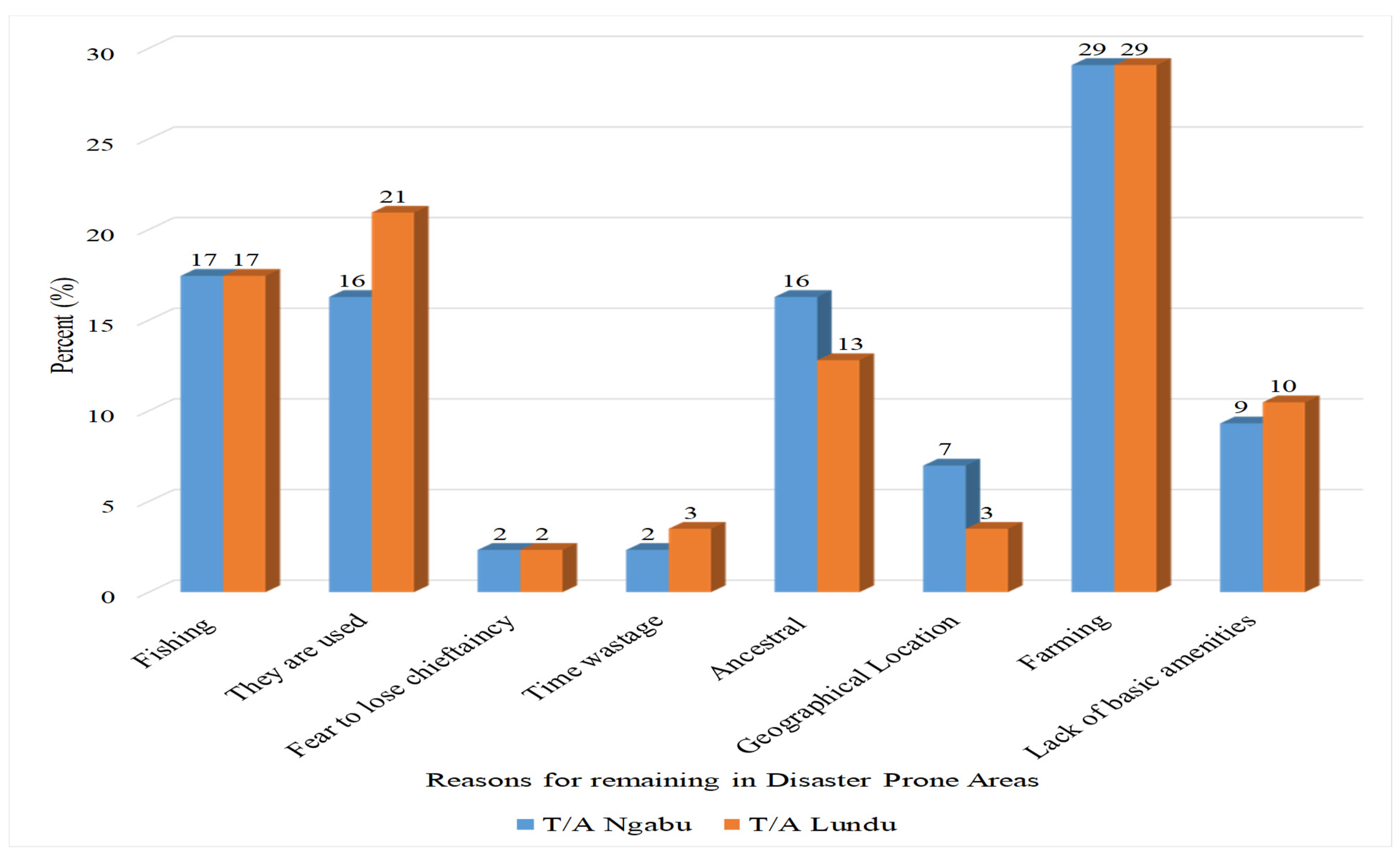
The findings showed that farming (29 %) was the main reason that prompted people to continue staying in the disaster-prone areas in both T/As Ngabu and Lundu. It was revealed that people had knowledge of the impeding disasters such as floods. The study found that floods brought them with alluvial soils which were good for crop production. Therefore, despite their negative effects, it was an opportunity to communities in T/As Ngabu and Lundu in Chikwawa District. Gren and Helander (2017) conducted a study in Tigdaranao in Philippines and found that farming prompted people to live in high risked areas. This is similar to the results of this study. However, risking life at the expense of farming is not a good strategy to reducing the impacts of disasters. The best strategy is to relocate.
Box 1. Are Disasters a Blessing and/or a Curse?
One of the respondents said “disasters are an opportunity as they bring about fertility good for crop production. Most of the parts of the district are dry and the soils are acidic. Maize does not grow well in arable lands. It only does well in areas where floods have occurred as they bring with them soil fertility suitable for maize crop production. Therefore, floods are necessarily evil. Floods also lead to employment opportunities hence development. Since there is no any other place to live and grow crops, we opt to remain here. However, disasters are a foe as they affect the health and standard of our wellbeing. Disasters lead to spreading of Sexually Transmitted Infections (STIs). For example, during floods in evacuation camps, family members are separated. This provides room for sexual malpractices hence transmitting Sexually Transmitted Infections (STIs) including HIV/AIDS. Lack of basic amenities and sanitary conditions in the evacuation centres also provides a platform for disease outbreaks such as cholera. During the onset of drought, women and children walk long distances to search for water. Sometimes they are raped hence spreading of Sexually Transmitted Infections. The disasters also lead to long term trauma. Children in this case are the most vulnerable population”. A Community Member at Chindoko Village, T/A Ngabu
The study also revealed that community members from Traditional Authorities Ngabu and Lundu were used to their areas and disasters were acts of God. However, more people (21%) were from Lundu. The findings revealed that community members just looked at these areas as their homes and disaster related impacts were part of life. The study found that even if people shifted to other areas, they would still be affected by disasters. The community members from Linga, Chindoko and Nsomo villages in Traditional Authority Ngabu argued that disasters were normal. In T/A Lundu, community members from villages such as Mafale, Pangilesi, Bester, Tizola and Sekeni, also said that disasters were not aberrant. They also argued that even if they would leave for upland areas, they would still face drought. Askman, Nilsson and Becker (2018) also conducted a study in Akuressa, in Southwest Sri Lanka and found that people had a sense of place implying they were used to it. This is also similar to what (Gren and Helander, 2017) found in Tigdaranao in Philippines.
The study found that people were protected by God and there was no other safer place than where they were living. This implies that disasters are inevitable. This is in line with what Contract-Expand and Disaster Management Continuum Models postulate. These models assume that disasters are inevitable. However, disasters are not. Disasters are as a result of failure to manage risks. This implies that a disaster in Malawi cannot be a disaster in Tanzania or United Kingdom. What is important is to have capacity to absorb the shocks or prepare in advance.
The findings also showed that fishing (17%) and 2% in T/As Ngabu and Lundu respectively, made people remain in the disaster-prone areas. Based on the findings, more people were from T/A Ngabu. The study revealed that people from Linga village in T/A Ngabu depended much on fishing and decided to settle along the Shire River. In T/A Lundu, community members from Sekeni, Thom, Pangilesi and Bester, used to go for fishing in the Shire River. This is similar to what (Gren and Helander, 2017) found in Tigdaranao in Philippines. The study found that fishing was a means for subsistence and a source of income. This then implies that disasters can be both a blessing and/or a curse. Disasters can bring back years of development and at the same time is a catalyst for development.
In line with this, Sanderson (2000) found that in Turkey, disasters turned back the development clock, destroying years of efforts and labour, and perpetuating poverty for those already poor in Turkey in 1999. However, Stephenson (2005), argues that disasters can provide unique windows of opportunity in development. In the wake of the 1986 earthquake in El Salvador for example, the health sector took advantage of the severe damage to the large children’s hospital to restructure and decentralize services so that the nation would not be dependent on the services of the mega hospital. This means that disasters bring windows for development opportunities including employment.
The findings of the study showed that resistance to relocate was aligned to ancestral reasons in T/A Ngabu with (16%) and 13% in T/A Lundu. It was revealed that land was a possession from their forefathers and they needed to enjoy this privilege. Leaving the land for some places, it was an insult to their forefathers and they would be angry with them. This is also similar to what Mtembenuzeni and Kushe, (2017) found in Traditional Authority Makhuwira in Chikwawa District. This was suggested by respondents who were above 61 years old and did not attain primary or secondary education. This implies that education has a bearing towards development. It is therefore important to civic educate communities to shift from such a thinking in order to reduce disaster related impacts.
The study also found that lack of basic amenities in areas that were set as permanent homes after relocation with 9% and 10% in T/As Ngabu and Lundu respectively, influenced people to remain in the disaster-prone areas. The findings showed there were lack of social services such as health, education and potable water including good transport networks. The absence of these services made community members to continue staying in the disaster-prone areas. This is in contrast with what Gren and Helander (2017) found in Tigdaranao in Philippines. Their findings showed that in Tigdaranao, there were primary schools and other services. Therefore, communities saw it not important to relocate while the services were available despite the occurrence of disasters. However, children who wanted to start high school were traveling long distances and parents met transportation costs.
The results also showed that geographical location 7% and 3% in T/As Ngabu and Lundu respectively, restricted communities to relocate. However, respondents from T/A Ngabu were more than those from T/A Lundu. The study unveiled that the geographical or physical location of Chikwawa District in the Lower Shire Valley forced people to remain in the disaster-prone areas. It was revealed that there were no other good places than where they were. This is also in line with what Wisner et al., (2005) in Pressure and Release (PAR) Model proclaim. This model assumes that physical factors determine communities’ vulnerability.
The study also found that people preferred to stay in the disaster-prone areas as they were afraid of outbreak of diseases in evacuation centres such as dysentery and cholera. This is similar to what Mtembenuzeni and Kushe (2017) found in Traditional Authority Makhuwira in Chikwawa District. To be precise, in evacuation centres there are normally few or no toilets. People are usually alienated to right to privacy as scores of people live at one place.
The findings showed that people were resisting to move out of the disaster-prone areas for fear of loss of chieftaincy with 2% in each T/A. The traditional leaders fear of losing the chieftaincy if they moved out. They feared that they would not be recognized as traditional leaders where they would resettle. Gren and Helander (2017) also had similar findings in Tigdaranao in Philippines. Their study revealed that leadership was a factor to remain in the disaster-prone area. Based on this, it can be deduced that power relations can lead to community vulnerability. This is also in concomitant with what Pressure and Release (PAR) model assumes. This model states that social systems lead to vulnerability of the community.
Box 1. Secondary Disasters
One of the local leaders said “I am a Group Village head and I have my own area of jurisdiction with my subordinates. If I would relocate, shall I still retain my chieftaincy? The government also must be serious on the welfare of people in the evacuation centres in case of floods. People are not well supported throughout the period when they are in evacuation camps. Sanitary conditions are also poor. Imagine scores of people against one toilet or bathroom. Is this healthy? Men and women usually meet in the bush as they go out for a call of nature. Assume people of different sexes have met in the bush, what would happen? This leads to another disaster (Sexually, Transmitted Infections including HIV/AIDS)”. One of the GVHs in T/A Ngabu.
Conclusions
Based on the major findings in this study as discussed in the preceding chapter, the concluding remarks have been made on the following areas:-
As per the major findings on the adaptive capacity of the community to disasters, this study concludes that communities at risk had their own mechanisms to adapt to disasters. These included; farming, river dredging, planting of trees, village savings, bee and livestock keeping, building houses like nests and stocking items. Despite not being recognized in the Malawi Disaster Policy, TEKS were highly valued in disaster risk reduction in Chikwawa District. It was found that community vulnerability was caused by geographical location, corruption, poor governance, lack of commitment by both communities and government, social, cultural and environmental factors.
Based on the major findings on the losses and damages incurred when disasters strike, this study concluded that disasters in Chikwawa District led to loss of human lives and livestock, damage to homes and crops including critical infrastructures such as roads, bridges, schools and electricity supply among others. However, disasters were also taken as an opportunity. Communities in Chikwawa District resorted to stay in floods disaster prone areas for farming, fishing, ancestral reasons and some were used to their place. The disasters that mostly affected people were drought and HIV/AIDS seconded by floods. Some of the disasters that were prevalent included; dry spells, strong winds, pest and diseases, pollution, crocodile attacks, fire, suicide and road accidents. These varied in frequency, spread and magnitude.
Based on the major findings on the adoption level of CBDRM in Chikwawa District particularly in Traditional Authorities of Ngabu and Lundu, this study concluded that communities adopted the CBDRM approach. Community participation was good and people were well organized. Despite the adoption of CBDRM, disaster episodes and losses were increasing in Chikwawa District. This implies that CBDRM was not a solution to the problems related to disasters in Chikwawa District hence was not effective. Lack of adequate timely support from government and other stakeholders in form of funds and humanitarian related resources to build the required capacity, made it ineffective. It can therefore be deduced that multisectoral approach to DRR was the best strategy to develop a robust Community-Based Disaster Risk Management (CBDRM) approach for disaster risk management and sustainable development in Chikwawa District. This can play an important role to the policy makers, decision makers, development actors and other stakeholders.
References
- Blaikie, P., Cannon, T. David, I. and Wisner, B., (1994). At risk: Natural Hazards, People’s Vulnerability, and Disasters. London: Routledge.
- Bentzen, J., S. (2018). Acts of God? Religiosity and Natural Disasters across Subnational World Districts. Copenhagen: Department of Economics, University of Copenhagen.
- BNPB, (2015). Indonesia’s Disaster Risk Management Baseline Status Report. Jakarta: BNPB Office.
- Bohle, H. (2001). Vulnerability and Criticality: Perspectives from Social Geography. https://www.researchgate.net/publication/281020579. Accessed on 16/04/19.
- Bongo, P., P. (2006). Community-Based Disaster Risk Reduction in the Context of Climate Change. The Case of Rural Zimbabwe (www.nuigalway).
- Borden, A., K., Schmidtlein, C., M., Emrich, C., T., Piegorsch, W., W. and Cutter, S., L (2007). Vulnerability of U.S Cities to Environmental Hazards. Journal of Homeland Security and Emergency Management. Vol. 4, Issue 2.
- Boyce, C. (2006). Conducting In-Depth Interviews: A Guide for Designing and Conducting In-Depth Interviews for Evaluation Input. Palena Neale: Pathfinder International.
- Brown, G., Raymond, C., M. and Corcoran, J (2015). Mapping and Measuring Place Attachment. Applied Geography. www.elsevier.com/locate/apgeog accessed on12/08/2018.
- Cannon, T. (2008). Reducing People’s Vulnerability to Natural Hazards: Communities and Resilience”, Research paper, WIDER, Helsinki: United Nations University.
- Caritas Czech Republic (2009). Making Community managed Disaster Risk Reduction Operation at Community Level: A Guide by Rustico “Rusty” Binas. Vladislavova 12: Caritas Czech Republic.
- Chambers, R. (1997). Whose Reality Counts?: Putting the First Last. London: Intermediate Technology Publications Ltd (ITP).
- Chambers, R. (2015). PRA, PLA and pluralism: Practice and theory. In Bradbury, H., The SAGE Handbook of Action Research (pp 31-46). Los Angeles: Sage.
- Chavula, G. (2013). A Report on Local Indigenous Knowledge Systems and Practices (LIKSP) in Malawi; Global Water Partnership-Southern Africa: Pretoria, South Africa, 2013.
- Coon, H. (2017). Genetic studies of Suicide Risk and research into Mental Illness: Department of Psychiatry, University of Utah School of Medicine. https://faculty.utah.edu/u0035633-HIRALY-COON/research/index.hml.
- Cordaid (2012). Risk Mapping Malawi Sector Disaster Risk Reduction and Energy Aid. In Evellien, Thieme Groen and Carolien Jacobs.
- Coulibaly, C., Jeanne Yekeleya, J., Mbow1, C., Kundhlande, G. & Musau, J. (2015). Mapping Vulnerability to Climate Change in Malawi: Lilongwe: Agricultural Research Station.
- Creswell, J. W. (2009). Research Design: Qualitative, Quantitative, and Mixed Methods Approaches. Los Angeles: University Of Nebraska-Lincoln.
- Creswell, J. W., and Clark, P. V. L. (2011). Designing and Conducting Mixed Methods Research (2nd ed.). Thousand Oaks, CA: Sage Publications, Inc.
- Cronin, S.J., Gaylord, D.R., Charley, D., Alloway, B.V., Wallez, S.; Esau, J.W. (2004). Participatory methods of incorporating scientific with traditional knowledge for volcanic hazard management on Ambae Island, Vanuatu. Bull. Volcanol. 2004, 66, 652–668.
- Cutter, S. L. (1996). Vulnerability to environmental hazards. Progress in Human Geography, 20(4), 529–539.
- Department of Climate Change and Meteorological Services (2016). Prospects of 2015/16 Rainfall Season in Malawi: Blantyre: Ministry of Natural Resources, Energy and Mining.
- Department of Disaster Management Affairs (2015). National Disaster Risk Management Policy: Department of Disaster Management Affair: Lilongwe, Malawi, 2015.
- East African Community (2012). Disaster Risk Reduction and Management Strategy (2012 – 2016) Final Draft. Arusha: EAC Secretariat Arusha, Tanzania.
- Emergency Capacity Building (ECB) (2007). Leaving the Disaster Behind in www.
- Emergency Capacity Buildingproject.org/publications/ECB3/leaving disaster_behind retrieved on 14/07/2018.
- FAO (2018). The Impact of Disasters and Crises on Agriculture and Food Security. Rome: FAO.
- Gero, A. Méheux, K. & Dominey-Howes, D. (2011). Integrating Community Based Disaster Risk Reduction and Climate Change Adaptation: Examples from the Pacific. Natural Hazards and Earth System Science. 11(1), 101–113.
- Grajavales, J. G and Silva, A. B (2018). Crocodile Attacks in Oaxaca, Mexico. An Update of its Incidences and Consequences for Management and Conservation. Acta Universitaria 28(on line first) 1-8. [CrossRef]
- Government of Malawi (2015). National Disaster Risk Management Policy. Available at: https://www.ifrc.org/docs/IDRL/43755_malawidrmpolicy2015.pdf.
- Haule, E. (2014). Assessment of Communities’ Coping Mechanisms to Geodisasters in The Vicinity of Oldoinyo Lengai, Northern Tanzania; A PhD Thesis: University of Dar es Salaam.
- International Institute of Rural Reconstruction (IRR) and Catholic Organization for Relief and Development Aid (CordAid) (2007). Building resilient Communities: A Training Manual on Community-Managed Disaster Risk Reduction, Relief and Aid Development, Philippines.
- India National Disaster Management Plan, (2018). A publication of the National Disaster Management Authority. New Delhi: Government of India.
- ISPONRE, DONRE of Ben Tre, WWF, (2013). Strengthening Community and Ecosystem Resilience against Climate Change Impacts. Viet Nam Case Study from Field Testing an Operational Framework for Ecosystem-based Adaptation Hanoi: The World Bank-Netherland Partnership Program.
- International Council for Science (ISCU), (2006). Natural and Human Induced Hazards and Disasters and Disasters in Sub-Saharan Africa.
- Jackson, E. (2010). The key steps in establishing Community Managed Disaster Risk Reduction in South Omo pastoralist areas. FARM-Africa’s Field Manual to Guide Practitioners in Ethiopia. Addis Ababa: Farm-Africa.
- Jabeen, H., et al. (2010). Built-in resilience: Learning from Grassroots Coping Strategies for Climate Variability. Environment and Urbanization, 22(2), 415–431.
- Jury, M. R. (2010). Malawi’s Shire River Fluctuations and Climate. [CrossRef]
- Kasperson, R. E., Kasperson, J. X., Dow, K., Ezcurra, E., Liverman, D. M., Mitchell, J.K., Samuel, J. R., O’Riordan, T. & Timmerman, P. (2001). “Introduction: Global Environmental Risk and Society”, in Kasperson, J. X. and Kasperson, R. E. (Eds), Global Environmental Risk, United Nations University Press, Tokyo, pp.1–48.
- Kienberger, S. (2005).P-GIS and disaster risk management: Assessing vulnerability with P-GIS methods–Experiences from Búzi, Mozambique. International Conference on 40 Participatory Spatial Information Management and Communication, 7-10 September. Nairobi.
- Koentjaraningrat (1987). An anthology in Indonesia. Journal of Southwest Asian Studies.18:217-34.
- Kotze, A. and Holloway, A. (1996). Reducing Risk: Participatory Learning Activities for Disaster Mitigation in Southern Africa. Portsmouth: Oxfam.
- Kumbuyo, C. P., Yasuda, H & Shimizu, K (2014). Fluctuation of rainfall time series in Malawi: The United Graduate School of Agricultural Sciences, Arid Land Research Center.
- Lassa J. 2018a, ‘Floods in Toineke during 1940s–2016’, viewed 15 January 2018, From https://indosasters.org/2018/01/24/documented-floods-in-toineke.
- Leedy, P., D. (1993). Practical Research: Planning and Design. N J: Prentice Hall.
- Letsei, M,. M., A (2015). An Assessment of Place Vulnerability to Natural Hazards in South-Western Lesotho (Quthing and Mohale’s Hoek Districts). A thesis submitted to the Faculty of Science, University of the Witwatersrand.
- Lewis, M. (1995). Focus Group reviews in Qualitative Research. Review of the literature. Research Electronic Reader.www.scu.edu.au/schools/gmc/a.
- Maskrey, A. (2011). Revisiting Community-Based Disaster Risk Management. Environmental Hazards. 10, 42–52.
- Mavhura, E., Manyena, S. B., Collins, A. E., & Manatsa, D. (2013). Indigenous Knowledge, Coping Strategies and Resilience to Floods in Muzarabani, Zimbabwe. International Journal of Disaster Risk Reduction, 5, 38–48.
- Metzgera, M.J., Rounsevellb, M.D.A,. Acosta-Michlikb,R, L., Leemansc, R., Schroter, D.(2006). The Vulnerability of Ecosystem Services to Land Use Change. Agriculture, Ecosystems and Environment. Wageningen: Elsevier.
- Mills, D. (2004). Defining community: A critical review of “community”. Family and Community History, 7(1), 5-12. doi:10.1179/fch.2004.7.1.002.
- Ministry of Agriculture, Irrigation and Water Development (2016). Shire River Basin Atlas. Lilongwe: Ministry of Agriculture, Irrigation and Water Development.
- Ministry of Natural Resources, Energy and Mining and Department of Climate Change and Meteorological Services, 2016): Annual rainfall. GoM.
- MoAFS (2012). Guide to Agricultural Production and Natural Resources Management in Malawi. Lilongwe, Malawi: Ministry of Agriculture and Food Security, Department of Agricultural Extension Services.
- Mung’ou, C. (2009). ICT in Disaster Management. A Case Study of Kenya Red Cross Society. Research Project submitted at the School of Journalism in fulfillment of the requirements of the degree of Masters of Communication Studies of the University of Nairobi.
- Mtembenuzeni J., and Kushe, J. (2018). Theory and Practice of Vulnerability to Disaster Flood Prone Areas in Chikwawa, Malawi. Environment and Ecology Research 6 (3): 137-146.2018. [CrossRef]
- Murali, L. G. P and Vijayalaskshmi (2014). India Fire Accidents in Buildings. Case Studies. International Journal of Emergency. Trends and Technology. Volume II No. 4.2014.
- Muttarak, R., and W. Pothisiri. (2013). The Role of Education on Disaster Preparedness: Case Study of 2012 Indian Ocean Earthquakes on Thailand’s Andaman Coast. Ecology and Society.18 (4): 51. [CrossRef]
- Mwale, F. (2014). Contemporary Disaster Management Framework Quantification of Flood Risk in Rural Lower Shire Valley, Malawi. PhD Thesis. Heriot- Watt University.
- Mwanje, J. I (2001). Issues in Social Science Research: Social Science Research Methodology Series Module 1, OSSREA, Addis Ababa.
- Nakmofa Y. & Lassa J., (2009). ‘Community based approach to disaster risk reduction and climate change adaptation towards sustainable livelihood: Ten years’ experience from PMPB Kupang’, Journal of NTT Studies 1(2), 136–146.
- New Horizon Social Environmental Sciences (2014). Primary School Atlas of Malawi: Nairobi Longhorn Publishers.
- Niekerk, van, D. & Coetzee, C. (2012). African Experiences in Community-Based Disaster Risk Reduction. Community-Based Disaster Risk Reduction. Emerald Insights. 333–349.
- NSO (2018). Malawi Population and Housing Census Preliminary Report. Zomba:.
- NSO, Malawi Government.
- Orodho (2004). Elements of educational and Social Science Research Methods (First Edition). Nairobi: Masola Publishers.
- OXFAM (2012). The Disaster Crunch Model: Guidelines for a Gendered Approach. Oxford: OXFAM.
- OXFAM (2017). Horn of African Drought: Kenya Drought Crisis: A Call for Action http://reliefweb.int/sites/reliefweb.int/files/resources/Kenya%20Sitrep%20No.%203.pdf.
- Pain, R., & Francis, P. (2003). Reflections on Participatory Research. Area, 35(1), 46-54.
- Page, J. (2014). The Role of Cargo Bicycles in Disaster Planning and Emergency Management. An Evaluation of the Disaster Relief Trials. Rider Manifest: 2013 Eugene DRT.
- Pan-African Emergency (2002). Disasters & Emergencies Definitions. Training Package WHO/EHA Pan African Emergency Training Centre, Addis Ababa. Updated March 2002 By EHA.
- Paripurno, Lassa, Jannah, Pristianto (2011). Community Based Disaster Risk Management (CBDRM) Guidelines. Indonesia: Indonesia Society for Disaster Risk Management and MPBI.
- Pauw, K., Thurlow, J., Bachu, M & (2011). The Economic Costs of Extreme Weather Events: A Hydro-meteorological CGE Analysis for Malawi. Environment and Development Economics. 16(2), 177–198.
- Phiri, A. (2014).Creating a model in Community Based Disaster Risk Management for Informal Settlements. A case of Kanyama Settlement, Lusaka-Zambia (Doctoral Dissertation, North-West University.
- Preston, J. (2012). Disaster Education: ‘Race’, Equity and Pedagogy. London: Sense Publishers.
- Rugumamu, W. and Haule, E. (2015). Linking School Environment to Geo Disaster Risk Reduction for Sustainable Development in Tanzania. International Journal of Humanities, Social Sciences and Education (IJHSSE). Vol. 2, issue 6, June 2015, PP91-98.
- Samuels, F., Harvey, P. and Bergmann (2008). HIV/AIDS in Emergency. Situations Synthesis Report. London: Overseas Development Institute.
- Scolobig, A., Shaw, R. (2012). Overview of Community-Based Disaster Risk Reduction. In Shaw, R. (ed). Community-Based Disaster Risk Reduction. Emerald Insights. 3–17.
- Sdobnikov, Y. (1983). Political Economy; Guidelines to Social Sciences. Moscow:Progress Publishers.
- Shaw, R. (2006). Critical Issues of Community Based Flood Mitigation: Examples from Bangladesh and Vietnam. Journal of Science and Culture. 72(1–2), 1–17.
- Shohid, M., S. (2016). Community Based Disaster Management Strategy in Bangladesh: Present Status, Future Prospects and Challenges. European Journal of Research in Social Sciences. Vol. 4 No. 2, 2016 ISSN 2056-5429.
- Sim, T., Dominelli, L and Lau, J. (2017). A Pathway to Initiate Bottom-Up Community-Based Disaster Risk Reduction within a Top-Down System: The Case of China.T. Sim, et al., Int. J. of Safety and Security Eng., Vol. 7, No. 3 (2017).
- Singh and Misra (2001). Road accidents analysis. A Case Study of Patna City. Urban Transport Journal 2 (2) 60-75.
- South Dakota Hazard Mitigation Team (2014). State Of South Dakota Hazard Mitigation Plan. Capitol Avenue: S.D Office of Emergency Management.
- Stephenson R.S. (2005). Disaster management of engineering professional development, https://www.cambridge.org/core/services.
- Sundrama, P., Pradesh, T. S., Raj, A. and Krishna, K. (2016). A Case study in Investigation of Fire Accident Analysis in Cotton Mills.14th International Conference on Humanizing Work and Work Environment. HWWE-2016.
- Strauss, A., and Corbin (1990). Grounded Theory Research: Procedures, Canons, and Evaluative Criteria. San Francisco: Human Sciences Press, Inc.
- Tanzania Social Action Fund (TASAF) (2010). Natural Disasters and Crises Response by TASAF. Case by Cecilia Costella and Erasto Malune. TASAF.
- Taubenbock, H., Post, J., Roth, A., Zosseder, K., Strunz, G., and Dech, S. (2008). A conceptual Vulnerability and Risk Framework as outline to Identify capabilities of Remote Sensing: Natural Hazards and Earth System Sciences. Vol.8, 409-420.
- Tewari A. (2018). Livestock Disaster Management for Small and Marginal Farmer of India.: https://www.researchgate.net/publication/324136725.
- Tearfund (2006). Reducing Risk of Disaster in Our Communities. New Delhi: Tearfund Root Resources.
- Thinda, T. K. A (2009). Community-Based Hazard and Vulnerability Assessment: A case Study in Lusaka Informal Settlement, City of Tshwane. A Dissertation Submitted to the University of the Free State.
- Trogrlić, R. S., Wright, G., Adeloye, A., Mwale, F (2017). Community Based- Flood Risk Management: Experiences and Challenges in Malawi. Heriot: School of Energy, Geoscience, Infrastructure and Environment, Heriot-Watt University, United Kingdom.
- UNDP (2010). Disaster Risk Assessment in Mozambique. A Comprehensive Country Situation. Analysis. Geneva, Switzerland: (UNDP).
- UNISDR (2005). Hyogo Framework for Action 2005-2015: Building the Resilience of Nations and Communities to Disasters. Kobe/Hyogo: United Nations.
- UNISDR (2009): Adaptation to Climate Change by Reducing Disaster Risk: Country Practices and Lessons. Briefing Note 02, UNISDR, Geneva, Switzerland.
- United Nations Office for Disaster Risk Reduction (UNISDR, 2015). The Sendai Framework for Disaster Risk Reduction 2015–2030.
- Vatsa, K.S. (2004). Risk, Vulnerability, and Asset-Based Approach to Disaster Risk Management. International Journal of Sociology and Social Policy, 24(10/11), 1-48.
- Vennemo, H., Aunan, K, Lindhjem, H and Seip, H, M (2009). Environmental Pollution in China: Status and Trends. Article in Review of Environmental Economics and Policy. https://www.researchgate.net/.
- Villordon, M., B., B (2014). Community-Based Flood Vulnerability Index for Urban Flooding: Understanding Social Vulnerabilities and Risks. http://tel.archives-ouvertes.fr/tel-011283.
- Von Kotze, A. & Holloway, A.,(1996). ‘Reducing risk: Participatory learning activities for disaster mitigation in Southern Africa. Oxford: Oxfam.
- Wamsler, C and Brink, E. (2015). From adaptive Capacity to Adaptation. Rethinking the Interface Between Institutions and Citizens: Lund, Sweden: Lund University Centre.
- Wilcox (1994). Community Participation and Empowerment: putting Theory into Practice. Water End York: Joseph Rowntree Foundation.
- Wisner, B., Blaikie, P., Cannon, T. and David, I. (2003). At risk: Natural Hazards, People’s Vulnerability, and Disasters. London: Routledge.
- Wisner, B., Blaikie, P., Canon, T. (2005). At risk: Natural Hazards, People’s Vulnerability, and Disasters. London: Routledge.
- Wisner, B. (2006). Let Our Children Teach Us, A Review of Education and Knowledge, in Disaster risk Reduction. Bangalore: Books for Change.
- Wisner, B., J.C. Gaillard, and I. Kellman (eds.), (2011).Handbook of Hazards and Disaster Risk Reduction. London, UK: Routledge.
- World Bank (2009). Climate Resilient Cities: A Primer on Reducing Vulnerabilities to Disasters. Washington, D.C.: The World Bank.
- World Bank (2010). Programme of Action for the Implementation of the Africa Regional Strategy for Disaster Risk Reduction (2006-2010). Ethiopia: AU.
- World Bank (2014). Reducing the Impact of Natural Disasters in Malawi: Empowering Citizens and Taking charge. Lilongwe: The World Bank, IDBR-IDA. www.worldbank.org/.../.
- Yamane, T. (1967). Statistics: An Introductory Analysis.2nd ED. New York: Harper.
- Yodmani, S. (2001). Disaster Risk Management and Vulnerability. Reduction: Protecting the Poor. Bank.http://unpan1.un.org/intradoc.
Figure 2.
Rivers and Inundated Areas in Traditional Authority Ngabu.
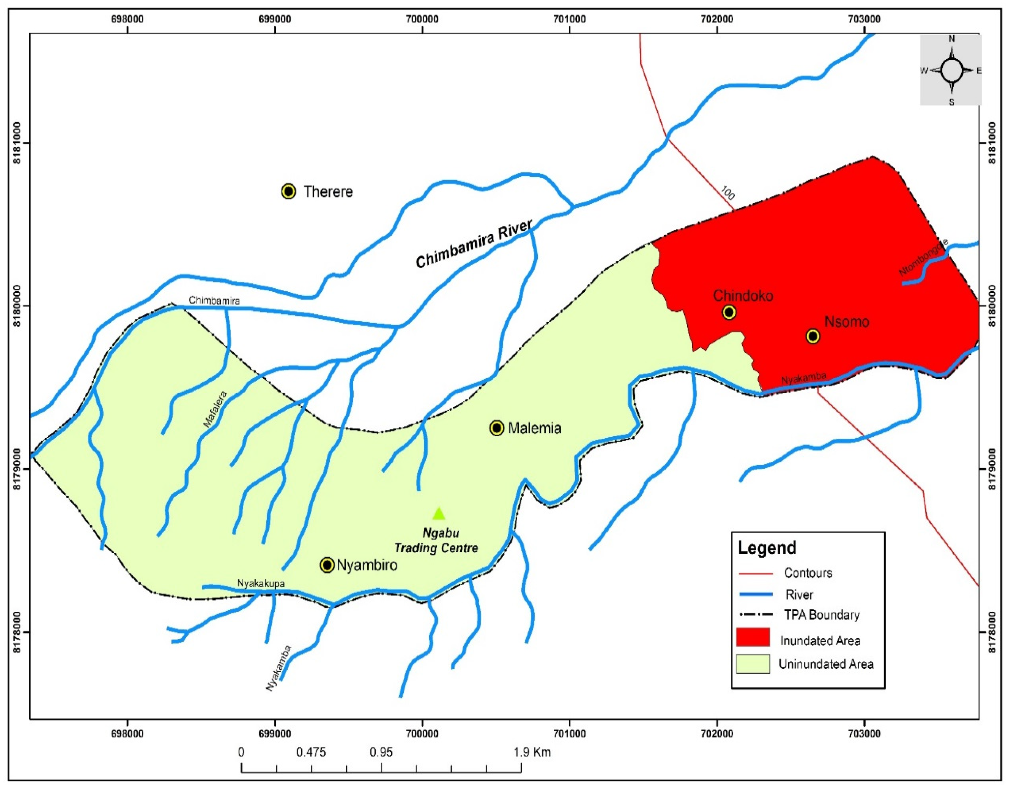
Figure 3.
Areas Under Cultivation in Traditional Authority Ngabu. Source: Tobias, November, 2018
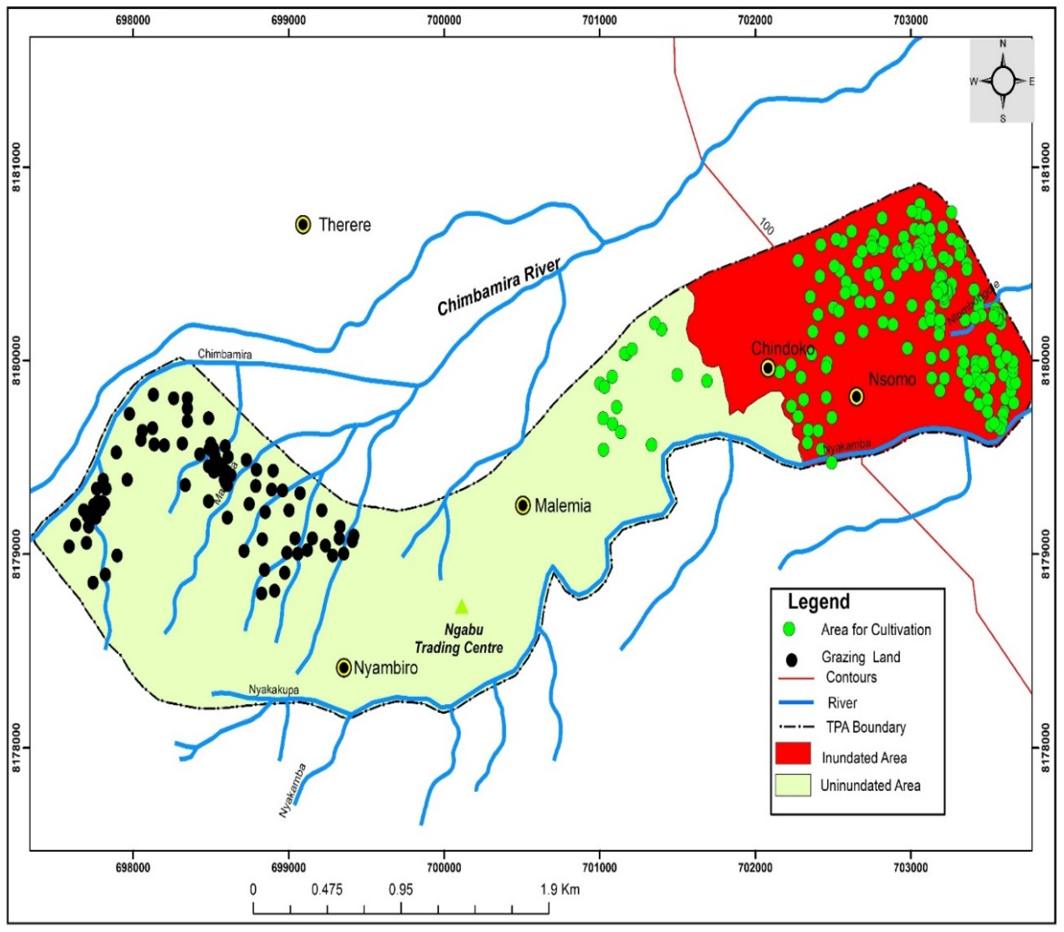
Figure 4.
Distribution of Social Services in T/A Ngabu. Source: Tobias, November, 2018
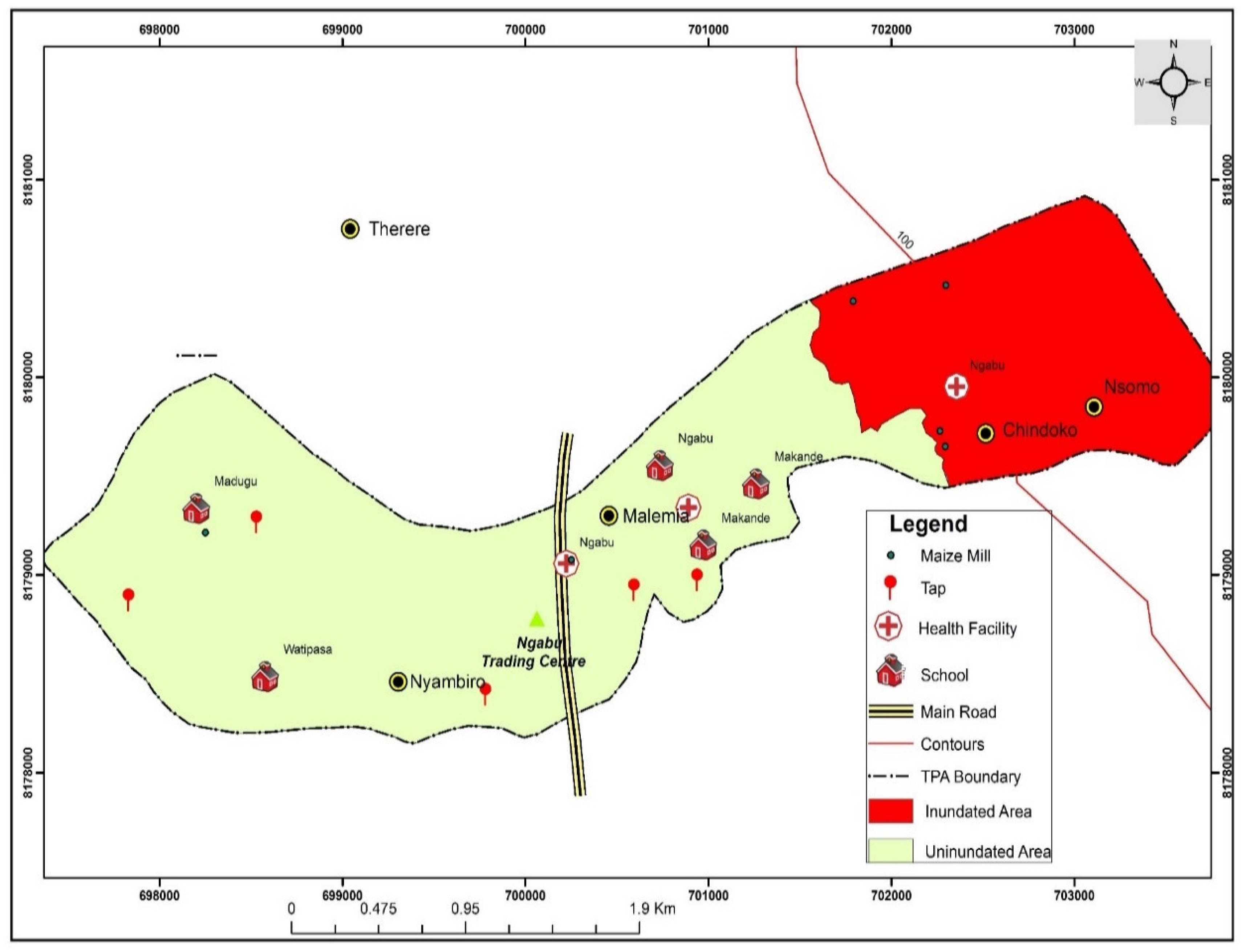
Figure 5.
Inundated Areas and Distribution of Social Services in T/A Lundu Source: Tobias, November, 2018
Figure 5.
Inundated Areas and Distribution of Social Services in T/A Lundu Source: Tobias, November, 2018
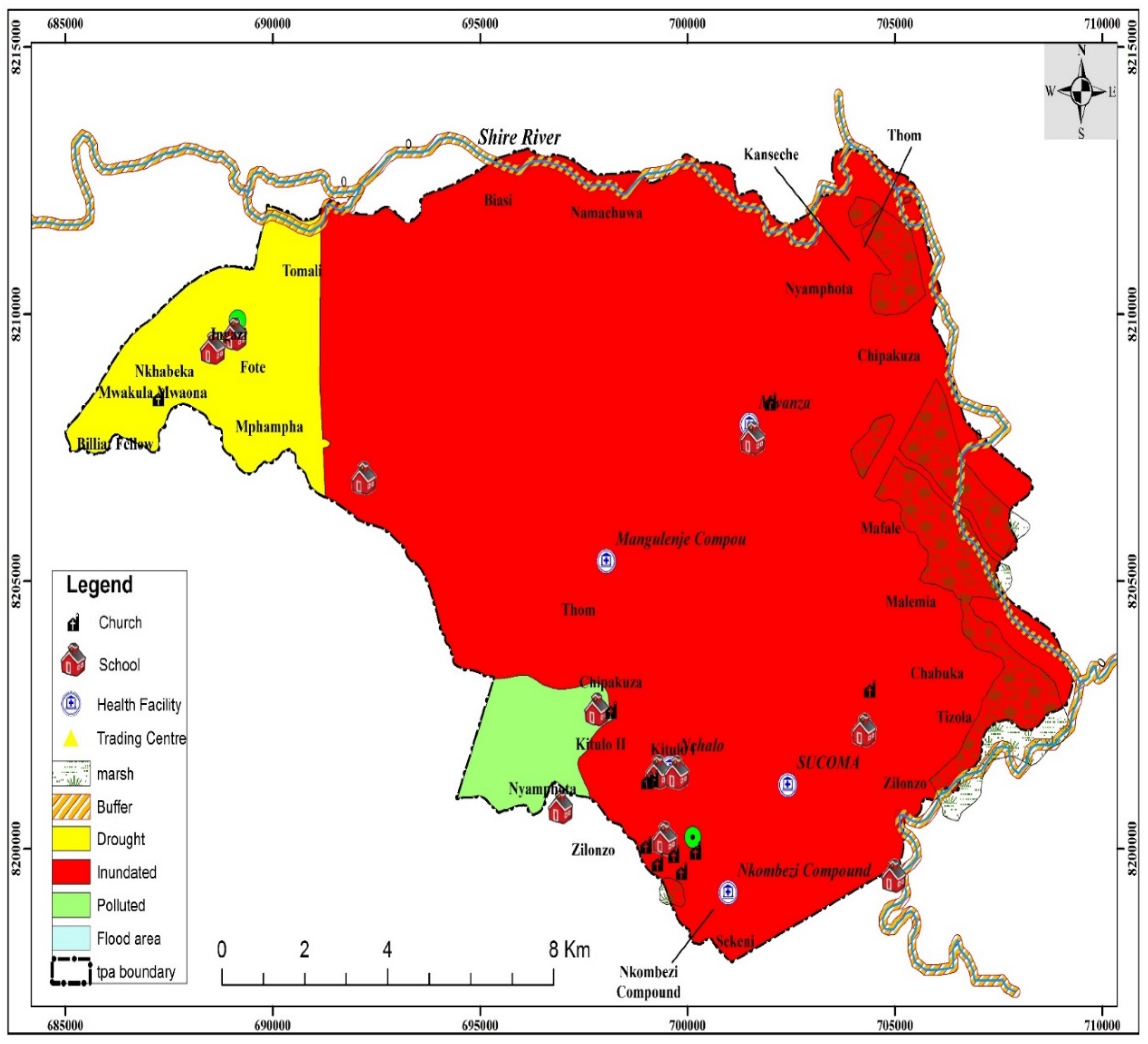
Figure 6.
Areas Under Cultivation and for Evacuation in T/A Lundu Source: Author, 2019
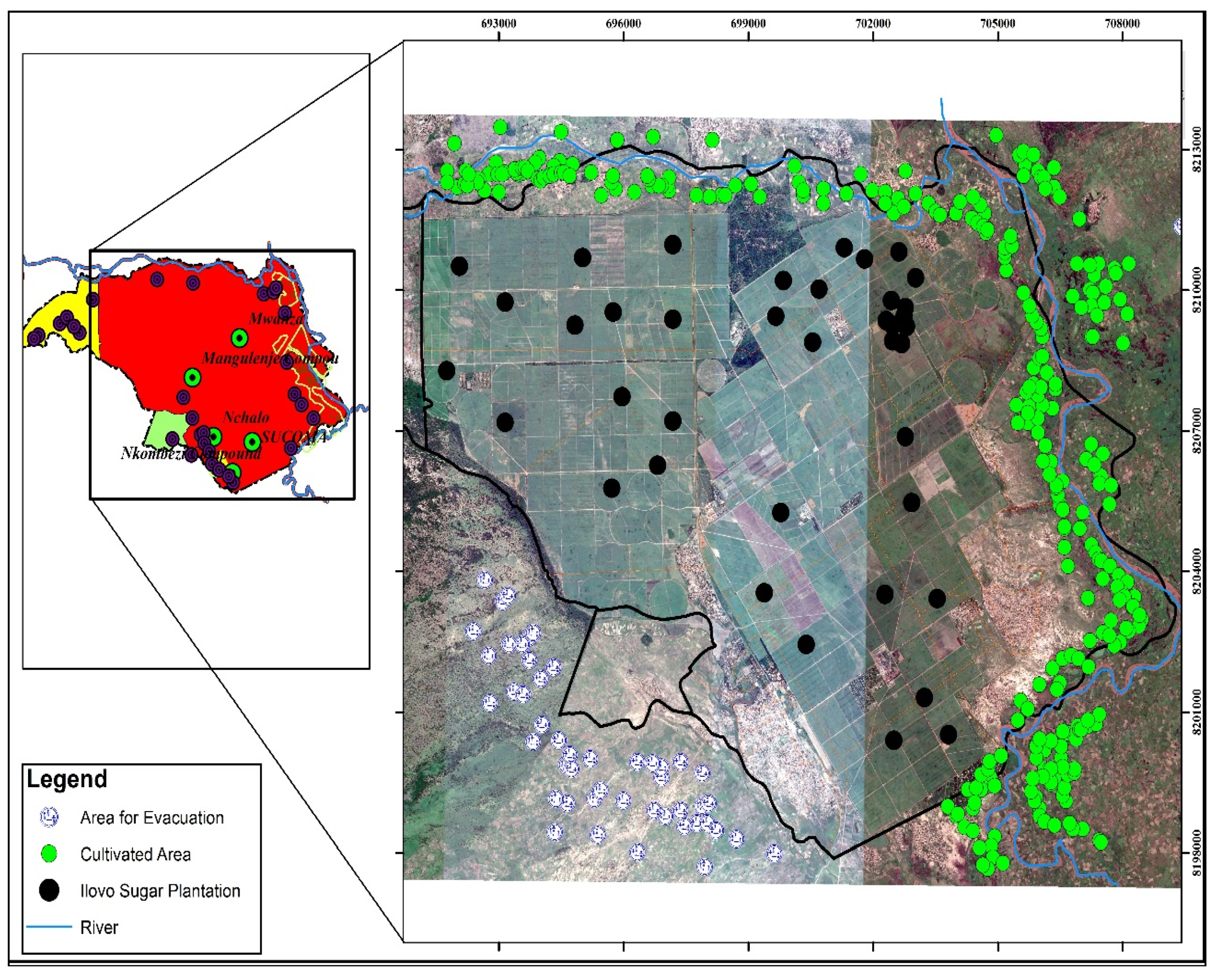
Table 1.
Vulnerability Assessment in T/A Ngabu and Lundu.
 |
Source: Field Data
Disclaimer/Publisher’s Note: The statements, opinions and data contained in all publications are solely those of the individual author(s) and contributor(s) and not of MDPI and/or the editor(s). MDPI and/or the editor(s) disclaim responsibility for any injury to people or property resulting from any ideas, methods, instructions or products referred to in the content. |
© 2024 by the authors. Licensee MDPI, Basel, Switzerland. This article is an open access article distributed under the terms and conditions of the Creative Commons Attribution (CC BY) license (http://creativecommons.org/licenses/by/4.0/).
Copyright: This open access article is published under a Creative Commons CC BY 4.0 license, which permit the free download, distribution, and reuse, provided that the author and preprint are cited in any reuse.


