1. Introduction
The Laboratory of Architectural, Cultural and Patrimonial Landscape (LAB/PAP) is a research group at the University of Valladolid, under the direction of Darío Álvarez and Miguel Ángel de la Iglesia, whose primary line of research focuses on the intervention and recovery of cultural and archaeological heritage landscapes [
1]. As a Recognised Research Group, it is characterised by a high level of specialisation in the field of heritage, with the development of a specific methodology of study, analysis and architectural intervention in the heritage landscapes in which it is called to operate [
2].
The term “Heritage Landscape” is used to define a set of elements, natural or man-made, articulated around valuable architectural remains with a certain degree of visibility, forming a series of superimposed memories over time, like a magnificent palimpsest. They constitute important systems to understand the cultural evolution of the territory, serving as tangible memory of our past, socially, historically and in terms of identity. However, they are usually difficult to interpret, even for those familiar with the subject [
3] (p. 25).
All citizens, regardless of age or disability, should be able to visit these sites to explore and enjoy their landscape values and architectural remains, interpreted by specialists, regardless of age or disability [
4] (p. 11). However, reconciling accessibility and heritage requires a sensitive perception of the environment and people’s disabilities. Finding the right balance between the two is rather difficult. The development of a single objective and a universal theory of accessibility in heritage is impossible [
5] (p. 6). Each case should be studied in depth in order to provide sensitive, useful, reasonable and respectful solutions, and therefore, finding this balance proves to be demanding and arduous [
6] (p. 24).
Even though more and more institutions and companies are convinced that it should be addressed from a social point of view, it has been often considered only from a physical accessibility perspective. In most cases only partial solutions have been offered, while a more comprehensible, truly sustainable, and inclusive approach needs to be adopted. The concept of inclusive design, which means embracing diversity, is essential to achieving the abovementioned balance.
In this sense, information design can play an essential role for the enjoyment and spread of knowledge of Heritage Landscapes [
7] (p. 76). Although these sites often have signage and even didactic interpretation centers, the information has not always been delivered in a way that suits the architectural and landscape project, nor with the parameters of inclusive design. It is essential to make a coordinated and multidisciplinary effort to approach projects from this perspective. This means that information design must be harmonised with architecture and landscape, in its definition of spaces, itineraries and flows, and with the logistics of services, in the creation of networks and the definition of information and management points. The inclusion of wayfinding resources requires a collaborative effort from architects, designers and sign creators [
8].
With the intention of promoting this multidisciplinary approach and taking advantage of the ongoing teaching in Architecture and Engineering in Industrial Design and Product Development, the authors began to consider that it could be enriching for these students to carry out their final projects following a line of research which is being developed within the research group: Information Design in Heritage Landscapes. The paper aims to show some reflections on this topic, which have led a group of students and lecturers within the LAB/PAP to develop experimental information and design proposals for the archaeological site of Tiermes, in Soria, Spain.
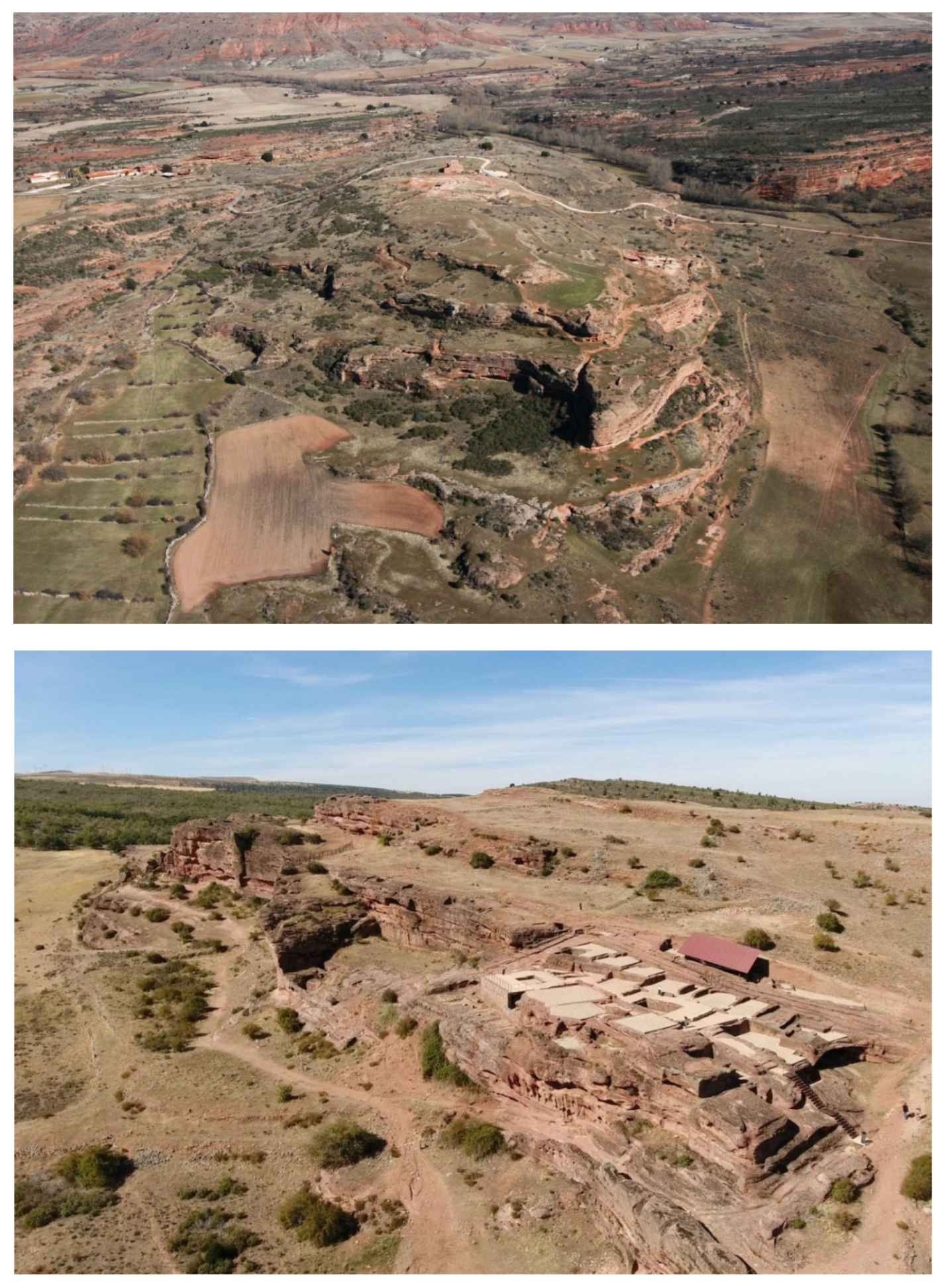
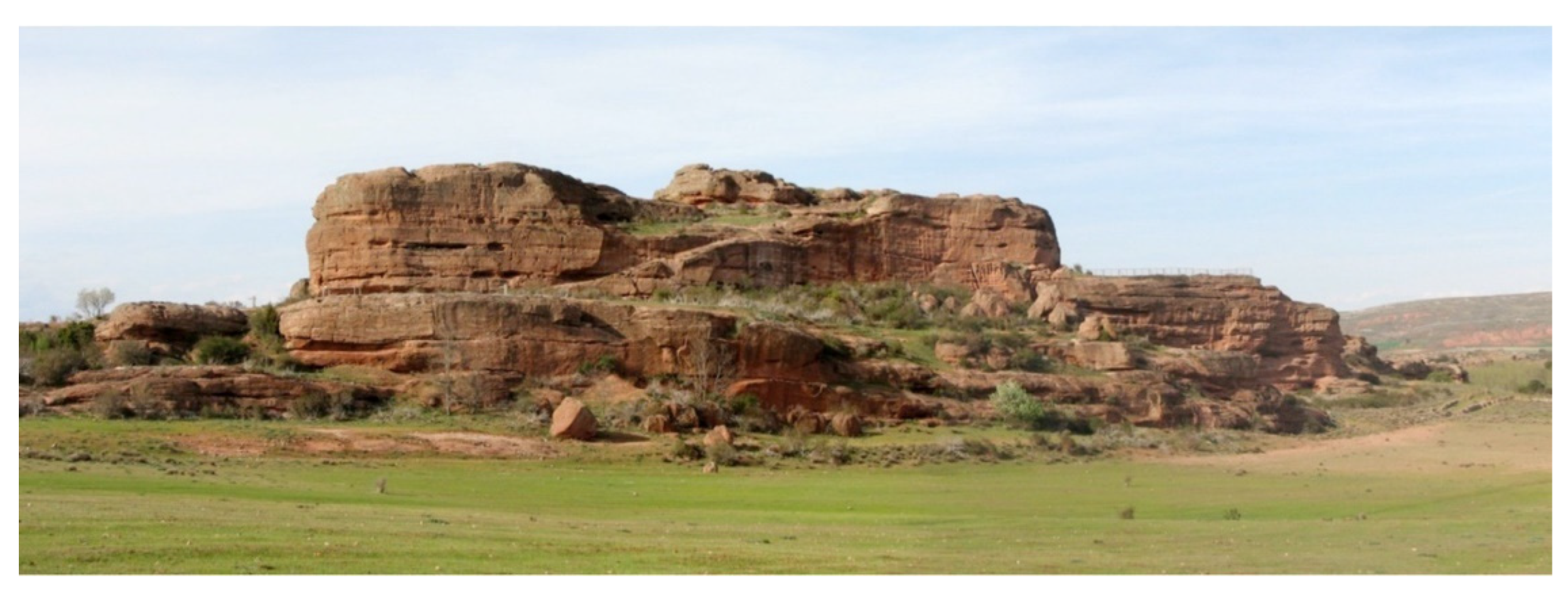
The archaeological site of Tiermes (Montejo de Tiermes, Soria) stands imposingly in a geographically privileged landscape, singularised by the natural topography of a terraced hill of red sandstone; a place inhabited and anthropised by man over time, with the Roman occupation standing out [
9]. The acropolis of the Roman city was located on this elevated site, using the rocky elevation as a natural fortification (
Figure 1a). The transformation of the original topography has left important remains of buildings carved into the rock, large ditches in the streets and an extensive network of excavated aqueducts, more than a kilometre long, which used to supply water for a city with the status of a Roman
municipium. Apart from the remains of the urban infrastructures, important archaeological vestiges are still preserved in the centre of the city, in the surroundings of the Romanesque hermitage of Tiermes, such as the late imperial wall, which from the third century onwards used to protect the east side of the city, and the Roman Forum, whose settlement benefits from the topographical unevenness on two levels: an upper square with temples on the north side and taverns on the rest, and a lower level with taverns and a perimeter
loggia open to the landscape. The Thermal Bath complex sits on a lower terrace and took full advantage of the elevation of the hill.
On the
Frente Sur (Southern Front) of the site, probably the most densely built part of the city, with a good orientation and views of the surrounding landscape of the Sierra de Pela, the remains of several groups of dwellings are still preserved, which utilise the large rock cliffs as structural support (
Figure 1b), with putlog holes still visible, and a series of spaces excavated in the sandstone rock that were originally used as storage areas for these dwellings [
10]. Of particular interest are the
Casas de Taracena, a group of two-storey semi-detached houses linked by internal staircases, and the
Casa del Acueducto (House of the Aqueduct, named after the pipe that runs along the adjacent street), with taverns and rooms partly dug into the rock, which still have the remains of the ceramic flooring which made them suitable for living comfortably. They used to form one or two large
domus, organised around two large
impluvia, which offered a privileged position wherefrom they could have enjoyed the unique views [
11].
The working methodology used is set out below, resulting in five different proposals, focusing on the design of the information, with the aim of presenting this exceptional site in an integrated and respectful way with the archaeological site. The following goals have been pursued: instilling in students the values of inclusive design; exploring different ways of applying inclusive design in heritage landscape information design; enabling the development of final projects in a real site; working in teams, encouraging shared knowledge and creating opportunities to test the solutions which are being designed [
12].
2. Materials and Methods
The methodology described in the subsequent paragraphs has been applied in the same way in on previous archaeological site projects, such as Clunia, in Burgos, Spain, a unique Roman site that has also been studied and worked on in depth within the LAB/PAP, one of whose directors is the architect Miguel Ángel de la Iglesia, who, together with Darío Álvarez, heads the research group. Thanks to the teachers’ in-depth knowledge of the site, the work produced excellent results of experimental nature which are of great use at the level of inclusive information design [
13].
2.1. Interpretation of the ruins
Prior to the work to be carried out by the students and teachers on designing the information, there is an important research work carried out by architects and archaeologists over several years on the ruins, which has led to various studies and projects.
In this respect, the prior analysis and interpretation of the archaeological heritage play a fundamental role, with legibility being one of the main objectives of the architectural intervention. Given the difficulty of understanding these remains for the citizen, the discourse on their preservation cannot ignore the fact that part of the intervention has to contribute to their comprehension and therefore cannot be considered only from the point of view of their elementary physical protection [
14].
This attitude lies in the understanding of the ruin as a residual part of a whole and, at the same time, as a figuration of what is absent, of what has disappeared in terms of architectural construction. It is the origin of the priority themes of intervention on Antiquity that lies in the understanding of a latent architectural entity within the archaeological traces: the restitution of the legibility of the remains, to which archaeologists and architects have historically devoted their shared efforts in response to the contemporary need to make both consolidated and diffuse ruins more clearly comprehensible. This way of research had its most fruitful application in the 20th century in Italy, especially in Rome as is evident from its morphology, and although today we could discuss its results, it represents the greatest moment of intertwinement between the disciplines, both focused on the interpretation and graphic reconstruction of archaeological remains, whose morphological and architectural study indicated the principles to be followed for their enhancement and understanding.
In the specific case of Tiermes, the need for interpretation was particularly relevant from the beginning, since the archaeological site was difficult to read, even for researchers, due to its geomorphological conformation. The unique layout of the city, characterised by an architecture excavated and carved into the rock, made it very difficult to understand and read at an urban, archaeological and constructional levels. For this reason,
Tiermes Laboratorio Cultural (Tiermes Cultural Laboratory) was constituted in 2007, an integrated working community created for the enhancement of the site of Tiermes, as a collaboration between the University of Valladolid and IE University (a private international university located in Segovia and Madrid), in a collaborative process of research, starting with the excavation and subsequent architectural interpretation [
15]. Thus, under the guidance of Tiermes Cultural Laboratory, new tools have been developed for the analysis, representation and interpretation of the place at different scales, both landscape and architectural, enabling the creation of an intervention methodology based on the architectural project, whose compositional rules are assumed in order to find the key to its enhancement. These interventions have significantly increased the physical accessibility of the archaeological remains, making it easier to visit the site, in addition to the important task of study and synthesis of the information and dissemination carried out, substantially improving the image and understanding of the ancient Roman city in the landscape.
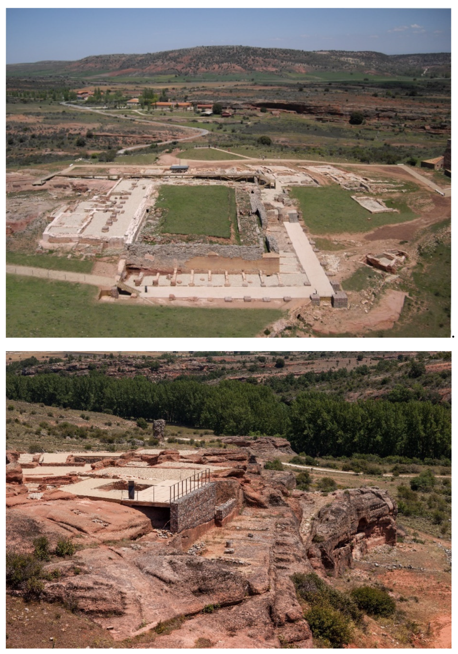
The course of action has focused on understanding the Celtiberian-Roman city and its most important archaeological sites (the Roman Forum and the so-called House of the Aqueduct) at two different levels (
Figure 2). On the one hand, the heritage remains have been integrated into the site, explaining them to the visitor from the landscape itself: accesses, views, singular points, external relationships, profiles, geometry, materials, topography, etc. On the other hand, it has intervened directly on the remains themselves, in order to allow a spatial understanding of them, superimposing a new geometry which, with clear, reversible and constructively compatible elements, would be able to facilitate the observation of the elements of interest, helping to understand their architectural implantation on the hill.
2.2. Theoretical. classes. Case studies and analysis of previous experiences
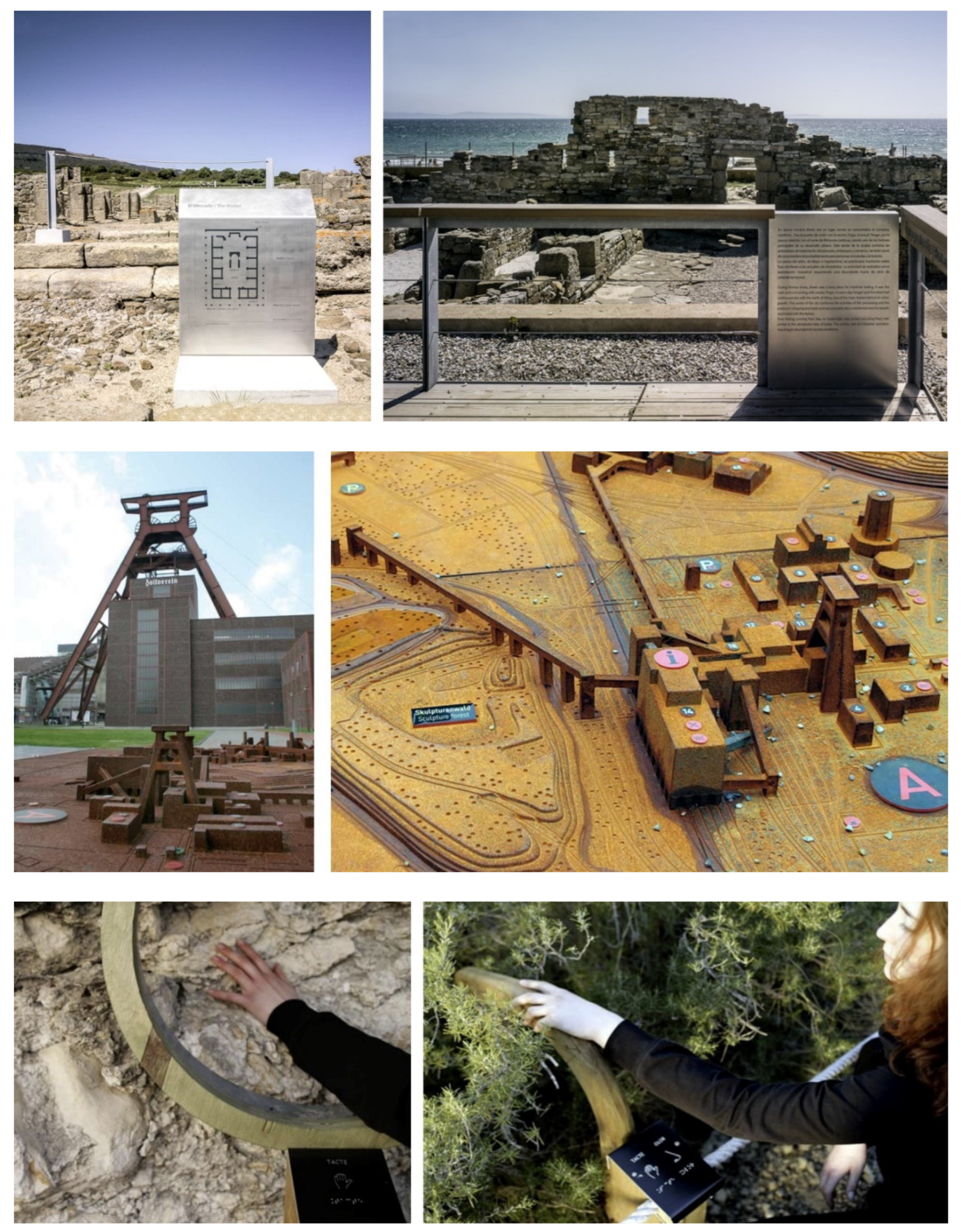
The methodology that has been followed began with informal theoretical classes, where some case studies of projects in Heritage Landscapes, which pay attention to inclusive design, were shown. The success and failure of information design solutions were analysed out loud and students were prompted to reflect on other examples, which could be shared within the group in subsequent sessions. Projects from natural to architectural, ancient to industrial heritage were analysed, considering different approaches to information access: sensory or cognitive, and even the use of digital media in situ (
Figure 3).
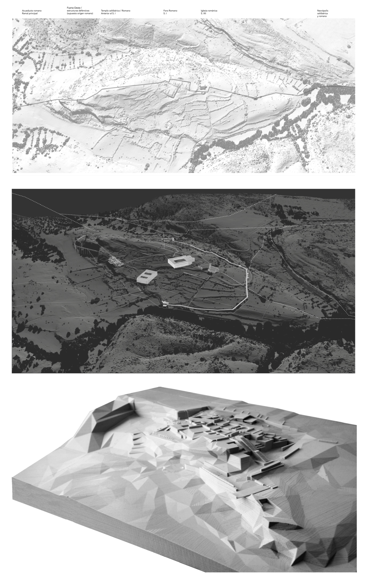
The work proposed to the students focuses on a heritage site such as Tiermes, where LAB/PAP has already carried out previous studies and projects, so that they can explain and provide basic information about the work carried out by the architects in collaboration with the archaeologists, and as explained above, show the interpretation given to the existing ruins. In general, complete data and certainties are not available, as there still are unexamined areas, and statements are often based on hypotheses (
Figure 4a–c). For this reason, the information is somewhat changeable; it is modified and expanded the more data becomes available.
2.3. Fieldwork. . Direct knowledge of the heritage landscape
Both in working with the students and in the subsequent development of their projects, the idea that a true understanding of a heritage element is only possible by interpreting the environment to which it belongs has been promoted. Although today’s digital media offer a range of possibilities of familiarising oneself with heritage landscapes without the need to visit them, it cannot be denied that direct knowledge definitely enhances our understanding and enjoyment. Some values, such as scale, proportion or materiality, can only be truly appreciated by experiencing them in situ.
This idea is supported by the concept of ‘situated learning’ [
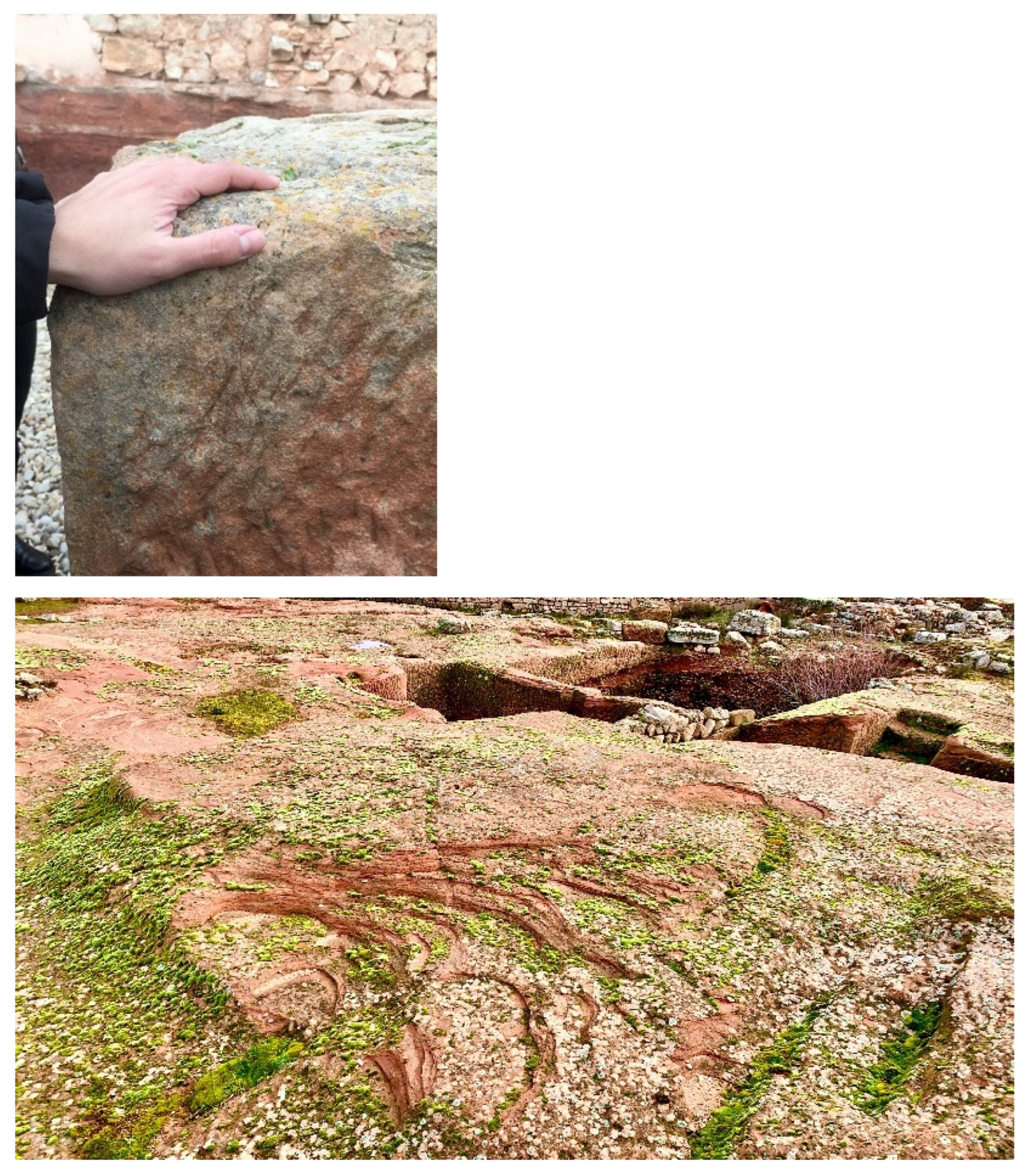
16]. According to this concept, the interpretation of a cultural heritage site is more effective when it is placed in its real context, thus giving a unique social and cultural value to the visit. Based on this concept, as soon as the opportunity arose, the students were taken to Tiermes where they developed their project about information design, trying to promote multisensory perception through smells, sounds, wind, haptic appreciation of materials, consideration of time, etc. For instance, they were asked to explore some of the fragments with their eyes closed, to enhance the sensory experience and to better understand the tactile qualities of the materials and the power of the wind at the site. This personal and sensory experimentation helps to deepen their research and enriches their projects (
Figure 5).
2.4. Workshop for discussion, supervision and testing
Final projects at the University of Valladolid are usually developed with a lecturer who regularly supervises the student’s work. However, one of the most important aspects in order to achieve the abovementioned objectives methodologically is to replace this individual tutoring with collective tutoring with discussion, supervision, and verification workshops.
The first sessions are designed to familiarise students with the topic of the work. They are based on the students’ search for examples to be analyzed out loud and for possible elements of information to develop. During these meetings, discussion is encouraged among students to in order to define how to brief each individual project. As the students develop their work, periodic sessions are held to supervise their progression. Students will carry on producing drawings, working models and 3D prototypes, while studying accessibility and inclusive design regulations and recommendations.
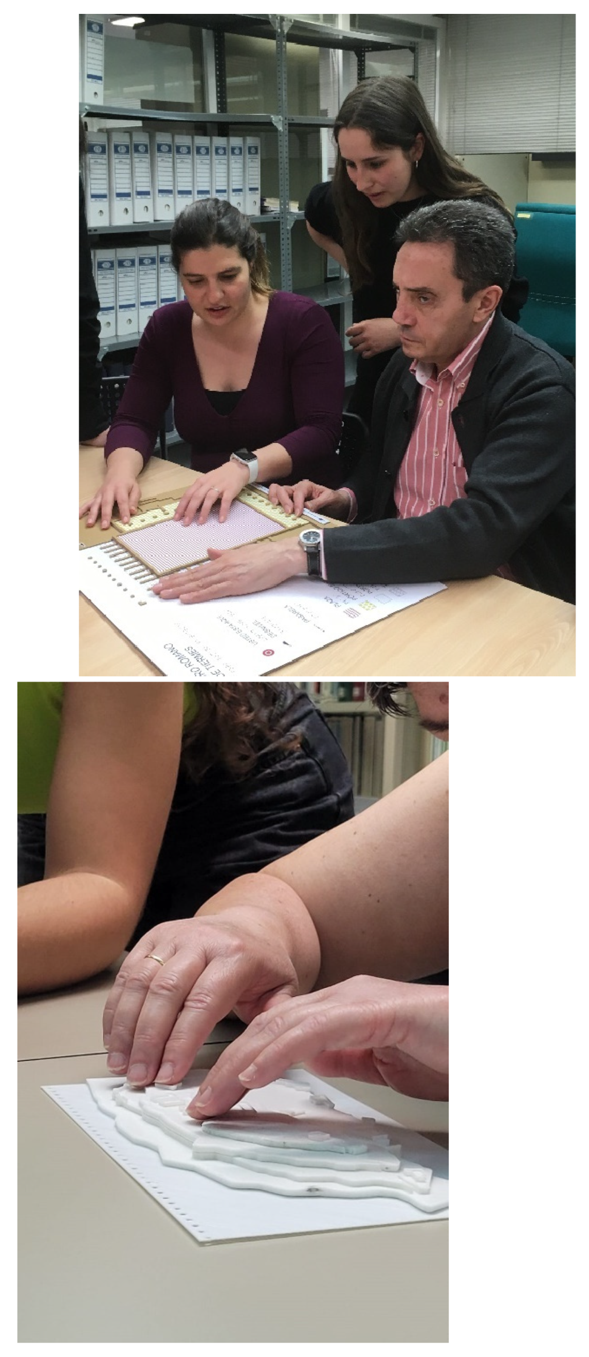
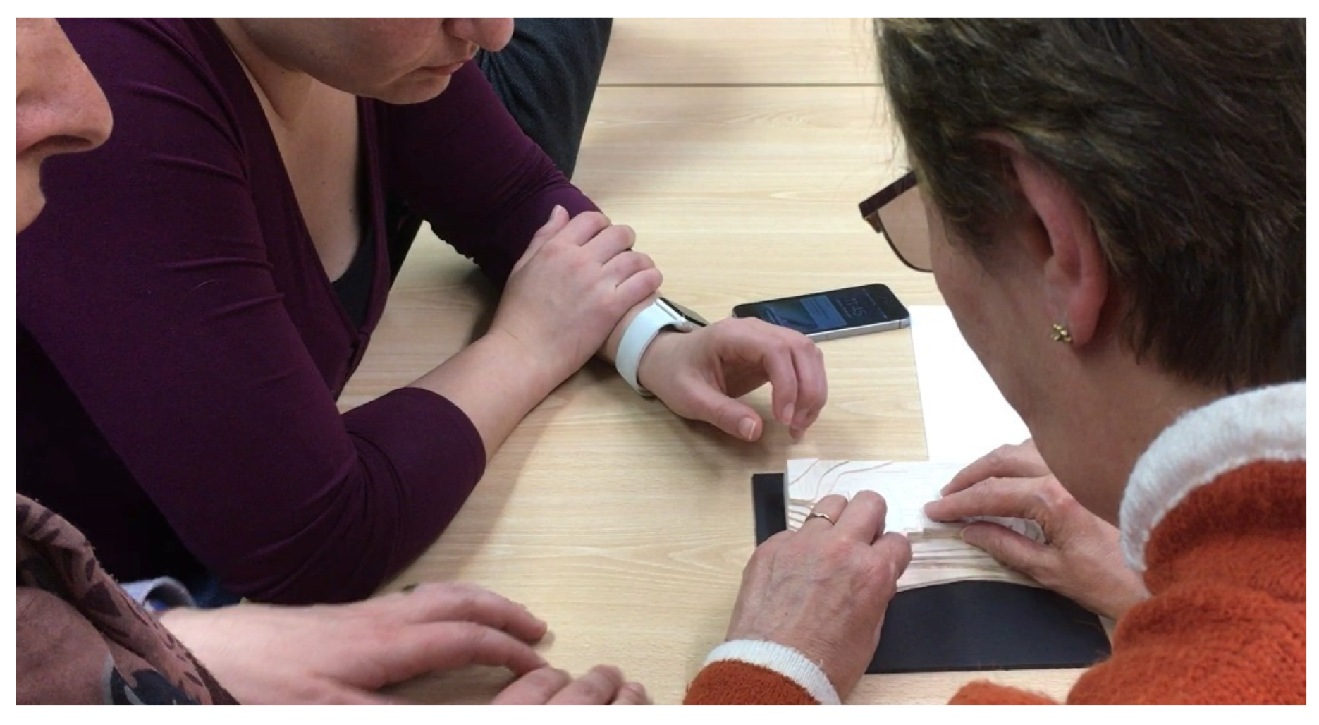
In some verification sessions, models are tested with users in an experimental workshop carried out in collaboration with ONCE, Spanish Organization of the Blind, with blind users or users with low vision, which allows relevant conclusions to be drawn for their assignments, such as the convenience of using ICT and tactile elements in a complementary way, depending on whether the information is ephemeral or permanent; the existence of the concept of tactile saturation, i.e. not abusing the use of textures wherever it can be avoided, in the case of tactile models or plans, and the convenience of using relief and not recesses in the designs (
Figure 6).
3. Results
As mentioned above, one of the main challenges for the research and dissemination of the
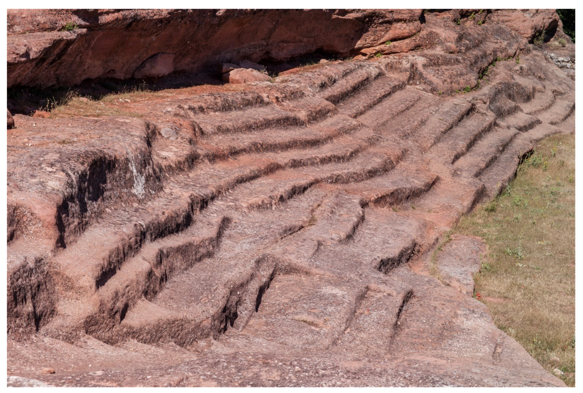
Tiermes Laboratorio Cultural is to explain and make understandable the artificial topography that shapes and characterises its landscape. The topographical relief that has been preserved to the present day is the result of a geological formation with differential erosion that, on the one hand, has given shape to the characteristic rocky terraces on which the city’s acropolis was built and, on the other hand, it has led to the intense occupation of these terraces in their three dimensions, with constructions that have left archaeological traces and remains, in most cases as elements dug into the rock itself. This double condition is reflected in the current topography of Tiermes, the result of the natural landscape and of the landscape anthropised or modified by man, mainly in Roman times, whose constructions have altered the rocky contours, with cuts, fissures and excavations, and in most cases still showing a strong geometric condition, clearly showing that it was a human settlement (
Figure 7).
Although all the architectural actions carried out by LAB/PAP in Tiermes have been aimed at improving the accessibility and understanding of the site, the Research Group also believe that the design of the information can further improve the understanding of the site and open it up to a greater number of users. Therefore, some teachers and researchers worked using the described methodology with a group of students to develop a number of projects, all with the aim of making the information as inclusive as possible and promoting the different parts of the site, as well as its identity and uniqueness, to a wider audience. Five proposals are introduced below, which present different approaches to this question.
3.1. General tactile model of Tiermes on a large scale
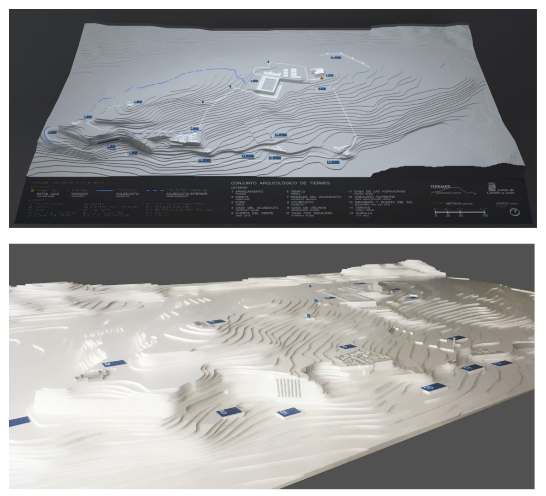
One of the proposals aimed to synthesise the landscape of Tiermes through a complete model of the archaeological area, measuring 1500 mm x 755 mm, which on the one hand reflects the significant topographical unevenness of more than 40 metres (between 1200 and 1240 metres altitude) in the four main platforms of the city, and on the other hand locates and represents the main archaeological remains present in some areas [
17] (
Figure 8).
These two complementary types of information take into account both the large scale of the topography and the architectural scale of certain complexes, such as the Forum, the Thermal Baths and the residential complexes on the southern front. The general topography is constructed from contour lines, simplified and arranged to clearly explain the large vertical cliffs, built from CNC laser-cut wooden planks. The archaeological remains are built from 3D digital printing models with PLA plastic in white, whose technology allows the pieces to be defined with greater precision, hence being able to depict the volume of the characteristic walls and platforms of these archaeologies
The advantage of working with this double material condition, for topography and archaeology, is that it allows the places where the most obvious archaeological sites are located to be clearly identified within the larger landscape. These points are also marked in contrast of colour and numbers, in relief and Braille, with references to a general legend, located at the bottom of the model.
3.2. Portable and tactile model for Tiermes
The experience of visiting the archaeological site of Tiermes involves very important problems of orientation, due to the pronounced orography. The design of a portable model becomes a great opportunity to facilitate the general understanding of the site and the specific orientation of visitors along the route, offering a lightweight material that follows the criteria of universal design, as it is both a visual and tactile device, trying to meet the needs of the greatest number of people through the use of a single object.
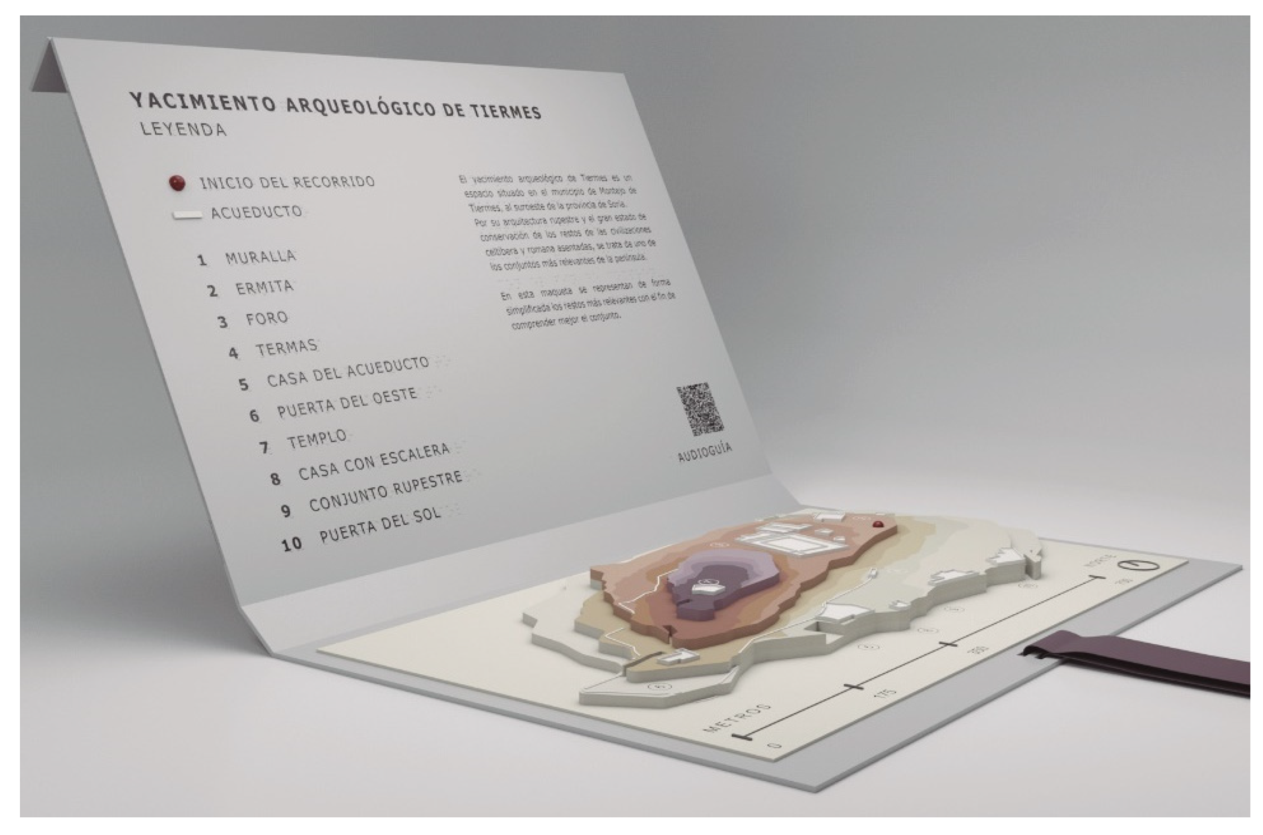
The model synthetically represents the topography of the Roman city through the four main platforms that comprise it, using different colours that follow a clear progression as the height increases, helping to understand the orography of Tiermes in a more intuitive way. On the other hand, the main archaeological remains are shown in relief and in white to present maximum contrast, which facilitates their identification. The product, designed by Marina Vega, has a ribbon so that it can be hung around the neck to leave both hands free during transport or movement, which is highly important to make it easier for visitors to walk around the site [
18]. The model is protected inside a light box measuring 265 x 176.5 x 18 mm which wraps around itself and is closed with a magnet, duplicating, when open, the surface on which the information and legend can be placed, which is provided both in visual alphabet and Braille (
Figure 9).
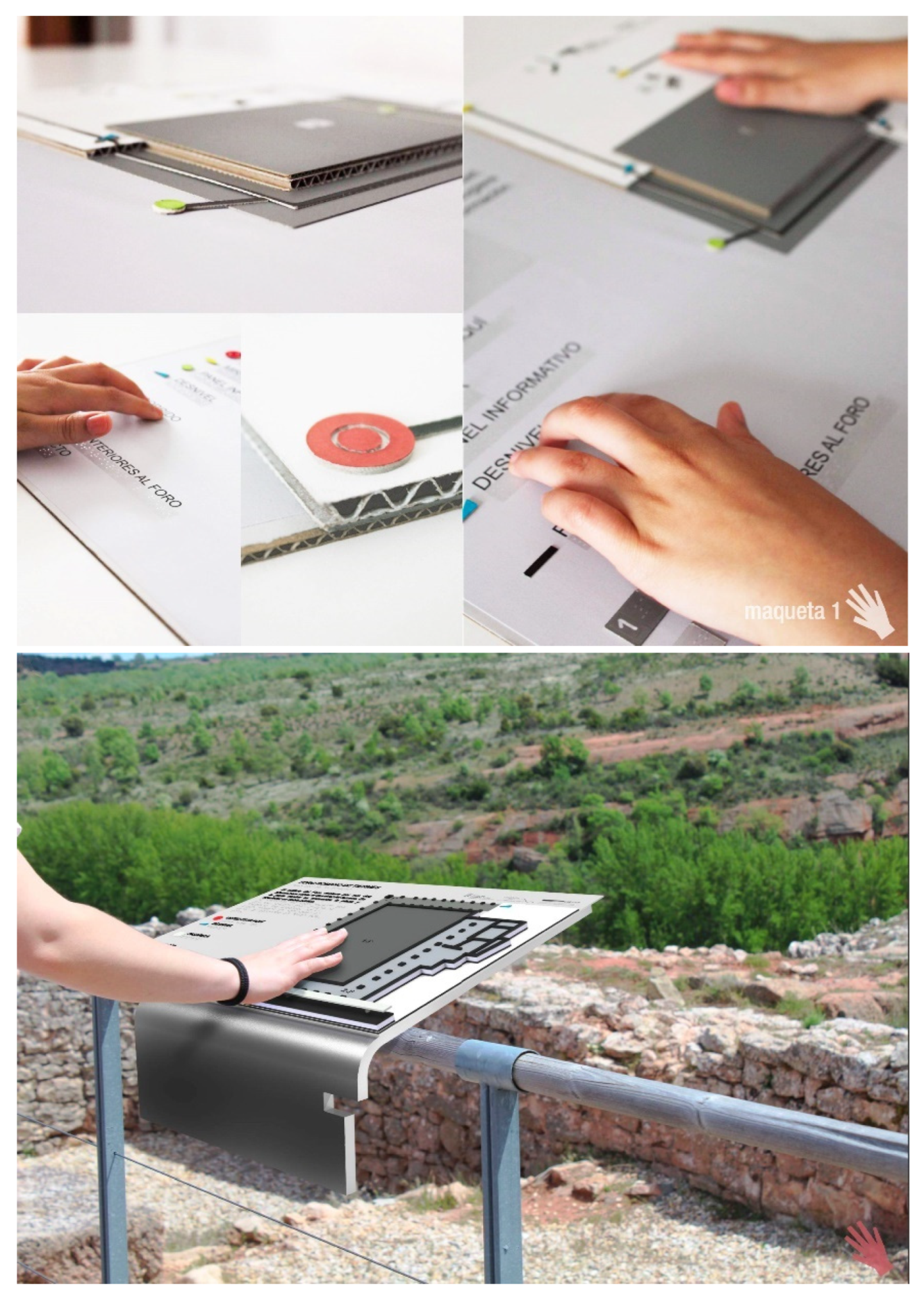
3.3. Signage with tactile maps
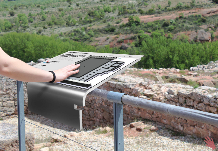
Another line of work that has been developed in Tiermes focuses on the design of an inclusive signage system for the Roman Forum, to make the visit more comprehensive and accessible in order to reach the greatest number of people.
The signs designed by María Pérez are the result, on the one hand, of the essentialisation of the main forms that structure the archaeological remains and, on the other, of experimentation with textures and symbols in relief that make it possible to provide the necessary information at the point along the route where it is easiest to understand. [
19] They form a single family, both in terms of the design of the representation codes and the layout of the information on the panel, and in terms of the support system, which is capable of adapting to different situations by means of variations on the same solution. The panels are located at four strategic points marked on the ground, and invite the visitor to pause during the tour, which is organised to provide information ranging from the general to the specific (
Figure 10).
The first sign sets the visitor in context and presents the general route, the most important elements and their location in relation to the immediate surroundings. The second sign, located on the walkway of the Roman Forum, shows the plan of the building in relief as it is preserved today, and gives precise information on the main elements of which it is composed. The third sign shows the elevation that opens out onto the landscape, so that the scale of the building and its composition can be understood. This information is complemented by the final experimental point, which presents one of the original pieces that composed the structure of the building, facilitating its tactile exploration.
3.4. Windows into the past
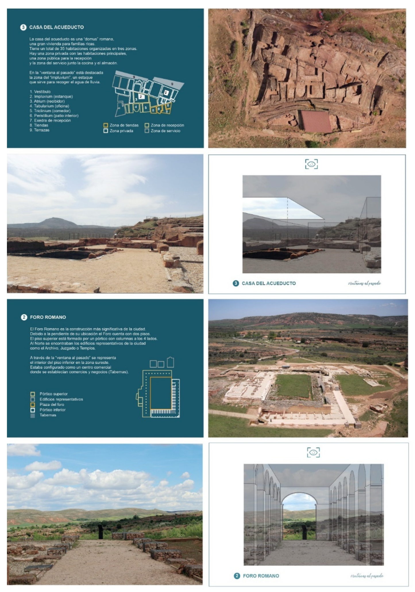
The proposal Windows into the past, developed by Laura Junco [
20], aims to carry out a work of interpretation and accessibility to cultural heritage, from a quasi-artistic approach, in the understanding of Marc Auge: “The contemplation of ruins allows us to catch a fleeting glimpse of the existence of a time that is not the one about which history books speak or the one that restoration works try to resuscitate… It is a lost time whose recovery is the task of art” [
21] (p.7). The purpose is to give the visitors an idea of what it would have been like to be in the ancient city of Tiermes, visualising the elevations of the volumes and architectural structures of the place in a simple and interactive way, making the users feel as if they were walking through the streets of Tiermes or entering its buildings. Although it was initially planned to install a series of signs on the place, using transparent methacrylate panels on which the volumes of the most representative buildings would be drawn, it was finally decided to use a much more accessible, economical and manageable format: a brochure that would facilitate the understanding of the ancient city and allow an individual use, less invasive for the site (
Figure 11).
Thus, some portable frames or windows are used, which make up an interactive brochure with a certain playful character, with the aim of bringing the site closer to different users, being especially attractive for children. With the intention of making it accessible to as many people as possible, the explanatory texts that can be found with the windows follow the guidelines of Easy Reading, so that people with cognitive disabilities can read them. The idea of presenting clear and understandable text for such audience, with particular attention to content, language, layout and illustrations, will undoubtedly make it easier for more users, including children and the elderly. Accompanying the brochure are a series of signs on the ground showing the user where to stand and where to look at. An attempt was made to include easily identifiable elements in the selection of the views that would make up the brochure. The result is a selection of 6 ‘windows into the past’ which are marked on the plan of the current route. In addition, instructions are included on a sheet, with intuitive text and icons, so that it can be easily used by everyone.
The brochure begins with brief general information about Tiermes, and then indicates the general itinerary, the way the booklet works, and the six
windows into the past that have been chosen, each of which will be explored later. They have been strictly designed to follow the same order and layout. A brief description, floor plan and aerial photograph are provided for each window. The frame is then accompanied by a photograph of the acetate drawing, which is intended to give the user an idea of the volumetric dimensions of the space they are looking at, of which today only a few ruins can be seen on the site. For example, in one
window, which corresponds to the
Casa del Acueducto, the purpose is to make the visitors feel that they are inside the domus. In the window to the past of this building, the interior of the house can be seen from the reception area, highlighting the
impluvium with its opening to the sky, the main element of the space. Another
window is dedicated to the Roman Forum and takes the user to the lower floor in the south-eastern area, which was configured as a commercial centre where, as explained above, there were shops and business areas, closed rooms called
Tabernae (
Figure 12).
3.5. Wayfinding App for Tiermes
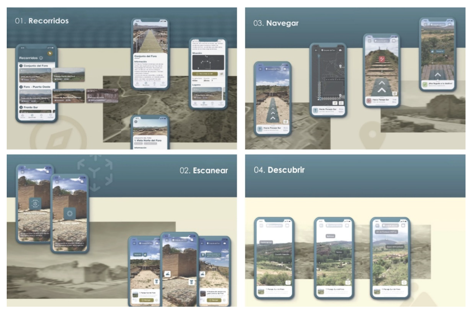
Carlos Matilla’s proposal for the design of information in the Tiermes archaeological site recommends a mobile augmented reality application for the site, with the aim of increasing knowledge, making it accessible and encouraging user participation [
22]. Thus, the designed phone application aims to improve the User Experience, guiding and orienting the visitor (wayfinding), and discovering the heritage assets through augmented reality experiences.
The application aims to complement the information already provided by the signage along the route and is therefore designed with the same corporate identity. It offers four main functions: tour, scan, navigate and explore. The first one proposes a visit to Tiermes in a fragmented way, dividing the general route into four partial itineraries, organised around the most relevant constructions or infrastructures of the ancient city. The first itinerary begins at the Roman Forum, on the north side of the hill. The second route starts from the Forum and continues westwards along the city’s roads and paths to the Casa del Acueducto and then to the Puerta del Oeste (Western Gate), the westernmost point and one of the main entrances to the city. The third itinerary takes the visitor down through the Puerta del Oeste to the Frente Sur, the group of cave constructions on the southern edge of the site. The last one includes a visit to the Graderío Rupestre, rock-cut grandstands, and the Puerta del Sol (Sun Gate).
The second function proposed by the application, scanning, aims to enable the application to detect the user’s location and provide information about it and the objects of interest within reach. The third function, navigation, uses augmented reality to show the visitor the route to follow. It also gives the orientation, distance and approximate time of the route to be followed, and can alternate with the visualisation of the map of the site if desired. The final feature, explore, uses geolocation to identify points of interest on the surrounding landscape, from which information can be obtained (
Figure 13).
4. Discussion
Once the different proposals have been described, a critical and realistic analysis should be made of which information systems are most useful and accessible so that they can be implemented at the site.
The creation of a global tactile model is considered to be very useful to obtain global information about the site in the first place. In general, a tactile model is useful to provide basic information and to understand the scale of the site and its different elements. It is useful for people with cognitive disabilities, children, the elderly... in short, for everyone. But if this object can be helpful in any place, in the case of Tiermes it is not only useful but almost essential, given its characteristics, since both its large size and its material homogeneity make it generally difficult to find one’s way around. For this reason, it was decided that the first action to be taken would be to start work on a complete model of the archaeological area, measuring 1500 mm x 755 mm, which will be placed in the archaeological museum at the site to welcome visitors before they start their tour.
Given the complexity of the site and the difficulty of remembering all the information, it is also considered a great help if the user can carry a portable model to guide him along the route. This object could be taken out of the museum and returned to it at the end of the visit. It will be prototyped and probably implemented with more information at key points along the route, such as texts in Easy Reading, as suggested in the Windows into the Past project. To begin with, Plena Inclusión organization and some people with cognitive disabilities have already collaborated in the testing of the texts, in order to ensure their correct adaptation. It is possible that, in the future, these easy-to-read texts will accompany also the current signs, either directly or by means of a QR code, and that some of the signs will have tactile elements, as suggested in the proposal for the Forum.
On the other hand, it is necessary to be aware of the fact that new technologies have become an ally in the dissemination and understanding of cultural heritage, bringing it closer to society. In this context, new interactive experiences can be created in a non-invasive way using tools such as smartphone applications or augmented reality. But they depend on devices, batteries and a good network, which is not always available in Tiermes, so in some ways they are less accessible.
The brochure ‘Windows into the Past’, although more limited in its functionalities, can be considered as a “low cost” virtual reality. Although it is also very attractive because of its playful character, its more limited scope makes it less inclusive, so it is postponed for the time being. However, it has been considered that the use of technology could be useful for people with physical disabilities or elderly who may find it difficult to complete the entire route, especially in areas with steep slopes such as the Puerta Oeste. In this sense, a possible future line of work is the creation of a virtual tour, similar to the one created by LAB/PAP in the Museum of African Art of the University of Valladolid [
23], with descriptions in English, Spanish and easy to read, understood as an accessibility measure that allows those who cannot visit the place to know it virtually.
Possibly with more limited functions than those offered by the application shown above, the virtual tour would be aimed more at non-in situ use. Although the proposal for the mobile phone application is very well designed, really complete and extremely attractive and intuitive, and could certainly be successful in the future, it is felt that the characteristics of the site should be emphasised by the physical experience, promoting as much as possible a sensory experience without excessive digital distractions: feeling the texture of the stone, the force of the wind, the variations in light, the sensation of changing scale depending on where you are in the site, ... in other words, enhancing not only the knowledge but also the landscape values of this incredible place.
The following words, by the Finnish architect Juhani Pallasmaa, underline the importance of building for the senses, which should always be at the basis of architects and designers work, enabling a better understood and more accessible environment:
‘The authenticity of architectural experience is grounded in the tectonic language of building and the comprehensibility of the act of construction to the senses.
We behold, touch, listen and measure the world with our entire bodily existence, and the experiential world becomes organised and articulated around the centre of the body’ [
24] (p.64).
Author Contributions
Conceptualization, N.F.V.; methodology, N.F.V., C.R.F. and S.F.R.; validation, N.F.V., C.R.F. and S.F.R.; formal analysis, N.F.V., C.R.F. and S.F.R.; investigation, N.F.V., C.R.F., S.F.R. and F.Z.; resources, N.F.V., C.R.F., S.F.R. and F.Z.; writing—original draft preparation, N.F.V., C.R.F., S.F.R. and F.Z.; writing—review and editing, N.F.V., C.R.F., S.F.R. and F.Z.; visualization, N.F.V. and C.R.F.; supervision, N.F.V., C.R.F., S.F.R. and F.Z All authors have read and agreed to the published version of the manuscript.
Funding
This work has been supported by the Spain Government, Ministry of Science and Innovation, through this Research Project: Accesibilidad y diseño inclusivo en paisajes patrimoniales. Análisis, estrategias de actuación y modelos de diseño de información. Ministerio de Ciencia e Innovación. Convocatoria 2020 de «Proyectos I+D+i» orientada a los retos de la Sociedad. PID2020-118216RB-I00/ AEI / 10.13039/501100011033.
Data Availability Statement
No new data were created or analyzed in this study. Data sharing is not applicable to this article.
Acknowledgments
The authors gratefully acknowledge the financial support of the Research Project: Accesibilidad y diseño inclusivo en paisajes patrimoniales. Análisis, estrategias de actuación y modelos de diseño de información. Ministerio de Ciencia e Innovación. Convocatoria 2020 de «Proyectos I+D+i» orientada a los retos de la Sociedad. PID2020-118216RB-I00/ AEI / 10.13039/501100011033. They also appreciate the enthusiastic participation of the students, as well as the kind collaboration of Araceli de las Heras and Jaime Catena, from ONCE, and all the users who have tested these projects.
Conflicts of Interest
The authors declare no conflicts of interest.
References
- Available online: https://labpap.uva.es/ (accessed on 01 June 2024).
- Álvarez Álvarez, D.; Miguel Ángel de la Iglesia Santamaría, M.A. Modelos de paisajes patrimoniales en Castilla y León: Herramientas de proyecto arquitectónico. In Modelos de Paisajes Patrimoniales. Estrategias de protección e intervención arquitectónica; Álvarez Álvarez, D., Miguel Ángel de la Iglesia Santamaría, M.A., Eds.; LAB/PAP, Dpto. Teoría de la Arquitectura y Proyectos Arquitectónicos, Universidad de Valladolid: Valladolid, 2017; pp. 8–27. [Google Scholar]
- Fernández Villalobos, N.; Fernández Raga, S.; Rodríguez Fernández, R. Un enfoque inclusivo para el diseño de información en los paisajes patrimoniales. In Diseño Inclusivo y Social; Puyuelo Cazorla, M., Ed.; Universitat Poltècnica de València: Valencia, 2021; pp. 25–37. [Google Scholar]
- Puyuelo Cazorla, M.; Val Fiel, M.; Merino Sanjuán, L.; Gual Ortí, J. Diseño inclusivo y accesibilidad a la cultura; Universitat Poltècnica de València: Valencia, 2017. [Google Scholar]
- Juncà Ubierna, J.A. El binomio Accesibilidad y Patrimonio. A la búsqueda de un equilibrio compatible. A Fondo, Boletín del Real Patronato sobre Discapacidad 2008, 64, 4–11. [Google Scholar]
- Fernández Villalobos, N.; Puyuelo Cazorla, M. Perception and Wayfinding at Cultural Sites. The International Journal of Visual Design 2018, 12, 19–34. [Google Scholar] [CrossRef]
- Fernández Villalobos, N. Diseño, información e identidad. In Modelos de Paisajes Patrimoniales. Estrategias de protección e intervención arquitectónica; Álvarez Álvarez, D., Miguel Ángel de la Iglesia Santamaría, M.A., Eds.; LAB/PAP, Dpto. Teoría de la Arquitectura y Proyectos Arquitectónicos, Universidad de Valladolid: Valladolid, 2017; pp. 76–83. [Google Scholar]
- García Moreno, D. Diseño de sistemas de orientación espacial: Wayfinding. In Accesibilidad Universal y Diseño para Todos. Arquitectura y Urbanismo; García Jalón, C. coord. Fundación Once, Fundación COAM: Madrid, 2011. [Google Scholar]
- Rodríguez Fernández, C. Topografías Arquitectónicas en el Paisaje Contemporáneo; Editorial Universidad de Sevilla, Instituto de Arquitectura y Ciencias de la Construcción: Sevilla, 2019. [Google Scholar]
- Rodríguez Fernández, C. El paisaje topográfico de Tiermes. La implantación arquitectónica de la ciudad romana en el territorio. In Tiempo, Culturas y Paisaje. La Colonia Clunia Sulpicia y su entorno; Diputación de Burgos: Burgos, 2023; pp. 208–227. [Google Scholar]
- Rodríguez Fernández, C. Topografía, Paisaje y Arqueología. Laboratorio de experimentación y representación en la Ciudad Romana de Tiermes. In Innovación para la gestión integrada del patrimonio, el paisaje y el turismo; Editorial Universidad de Sevilla/ Ediciones Universidad de Valladolid: Sevilla, 2020; pp. 178–197. [Google Scholar]
- Fernández Villalobos, N.; Fernández Raga, S.; Rodríguez Fernández, C. Investigación en Diseño de Información en Paisajes Patrimoniales. Talleres y Tutorías grupales para el desarrollo de Trabajos Fin de Grado en Ingeniería en Diseño Industrial y desarrollo de Producto. Proceedings of CUIEET 29, Escuela Técnica Superior de Ingeniería del Diseño, Valencia, España, 19–22 July 2022; pp. 297–302. [Google Scholar]
- Fernández Villalobos, N.; Fernández Raga, S. , Rodríguez Fernández, C. Inclusive Design of Information in Heritage Landscapes. Experimental proposals for the Roman Theatre of Clunia, Spain. In Proceedings of HERITAGES: Past and Present – Built and Social, AMPS, VŠFS Prague and the Czech Technical University, Prague, 28-30 June 2023; pp. 740– 751. [Google Scholar]
- Zelli, F. Legittimare il progetto in ámbito archeologico. Riflessioni al margine. In Innovación para la gestión integrada del patrimonio, el paisaje y el turismo; Editorial Universidad de Sevilla / Ediciones Universidad de Valladolid: Sevilla, 2020; pp. 74–85. [Google Scholar]
- Arribas Lobo, P.; Fernández Raga, S.; Rodríguez Fernández, C.; Zelli, F. Tiermes Cultural Lab: Excavation, conservation and utilization of the archaeological site of Tiermes (Soria, Spain). In Procedia Chemistry; Elsevier. 2013, 8-1, pp.328-336.
- Scribner, S. Thinking in action: Some characteristics of practical thought. In Practical intelligence: Nature and origins of competence in the everyday World; Sternberg, J., Wagner, R.K., Eds.; Cambridge University Press: Cambridge, England, 1986; pp. 13–30. [Google Scholar]
- Sánchez Martínez, C. Diseño de maqueta accesible para el conjunto arqueológico de Tiermes. Bachelor’s Thesis, Degree Final Project, Engineering in Industrial Design and Product Development University, University of Valladolid, Spain, 2019. [Google Scholar]
- Vega Maestro, M. Diseño de maqueta portátil accesible para el yacimiento arqueológico de Tiermes. Bachelor’s Thesis, Degree Final Project, Engineering in Industrial Design and Product Development University, University of Valladolid, Spain, 2023. [Google Scholar]
- Pérez Chicharro, M. El foro en tus manos. Una visita inclusive al Foro Romano del Yacimiento de Tiermes. Bachelor’s Thesis, Degree Final Project, Engineering in Industrial Design and Product Development University, University of Valladolid, Spain, 2019. [Google Scholar]
- Junco Cañedo, L. Ventanas al pasado. Diseño de un folleto interpretativo del Yacimiento Arqueológico de Tiermes. Bachelor’s Thesis, Degree Final Project, Engineering in Industrial Design and Product Development University, University of Valladolid, Spain, 2019. [Google Scholar]
- Augé, M. El tiempo en ruinas; Gedisa: Barcelona, España, 2003. [Google Scholar]
- Matilla Pérez, C. Realidad Aumentada móvil y patrimonio cultural. Aplicación de wayfinding in Tiermes. Bachelor’s Thesis, Degree Final Project, Engineering in Industrial Design and Product Development University, University of Valladolid, Spain, 2019. [Google Scholar]
- Merillas Benito, J; Fernández Villalobos, N; Álvarez Álvarez, D. LAB/PAP. Tour Virtual del Museo de Arte Africano Arellano Alonso. Universidad de Valladolid. Available online: https://www.fundacionjimenezarellano.com/visita_virtual_museo/index.htm (accessed on 20 June 2024).
- Pallasmaa, J. The eyes of the skin: Architecture and the senses; John Wiley & Sons: England, 2007. [Google Scholar]
Figure 1.
Archaeological site of Tiermes: (a) Aerial view from the west, where the four terraces that make up the acropolis of the ancient Roman city can be clearly seen. Photo: Architectural Photogrammetry Laboratory, University of Valladolid (LFA-UVa); (b) General view of the Southern Front of Tiermes with the rock cliffs where remains of the excavated architecture of the Roman city can be seen. Photo: Carlos Rodríguez Fernández, LAB/PAP.
Figure 2.
Projects carried out by the Laboratory of Architectural, Cultural and Patrimonial Landscape: (a) Architectural intervention and restoration of the Roman Forum of Tiermes, 2010. Photo: Miguel Ángel de la Iglesia Santamaría, LAB/PAP; (b) Architectural intervention and restoration of the Tiermes House of the Aqueduct, 2014. Photo: Paulo Paiva Fonseca.
Figure 4.
Three-dimensional models of Tiermes. (a) Model generated from a 2x2 km LIDAR laser survey (1m mesh pitch), available at the Spanish National Geographic Institute (IGN); (b) Model with the location of the most representative buildings, the Roman Forum, the Roman Baths and the House of the Aqueduct, the late-imperial wall, the access roads and streets of the Roman city and the layout of the aqueducts; (c) Model of the House of the Aqueduct complex generated from a photogrammetric survey and printed in 3D. Source: Carlos Rodríguez Fernández, LAB/PAP.
Figure 5.
Focusing on the sensory perception of the site (a) Visitors discover the qualities of the rock through the sense of touch. Photo: Sagrario Fernández Raga, LAB/PAP. (b) The excavated construction and the erosion of the characteristic rock reinforce the haptic character of the Tiermes landscape. Photo: Carlos Rodríguez Fernández, LAB/PAP.
Figure 6.
Experimental workshop carried out in collaboration with ONCE, in Valladolid, on 26/04/2019 and on 8/06/2023. Photos: Nieves Fernández Villalobos and Sagrario Fernández Raga.
Figure 6.
Experimental workshop carried out in collaboration with ONCE, in Valladolid, on 26/04/2019 and on 8/06/2023. Photos: Nieves Fernández Villalobos and Sagrario Fernández Raga.
Figure 7.
Tiermes is a product of erosion and the built landscape of the Roman city, a balance between the natural landscape and the anthropized landscape: (a) Rock platforms whose silhouettes can be seen the action of wind and erosion. Photo: Sagrario Fernández Raga, LAB/PAP; (b) Rock steps, an amazing artificial topography excavated in the rock. Photo: Paulo Paiva Fonseca.
Figure 8.
Proposal designed by César Sánchez Martínez. Bachelor’s Degree Final Project, Engineering in Industrial Design and Product Development, University of Valladolid. Directed by Nieves Fernández Villalobos, Carlos Rodríguez Fernández and Sagrario Fernández Raga, LAB/PAP.
Figure 8.
Proposal designed by César Sánchez Martínez. Bachelor’s Degree Final Project, Engineering in Industrial Design and Product Development, University of Valladolid. Directed by Nieves Fernández Villalobos, Carlos Rodríguez Fernández and Sagrario Fernández Raga, LAB/PAP.
Figure 9.
Proposal designed by Marina Vega Maestro. Bachelor’s Degree Final Project, Engineering in Industrial Design and Product Development, University of Valladolid, Spain, 2023. Directed by Carlos Rodríguez Fernández, Nieves Fernández Villalobos and Sagrario Fernández Raga, LAB/PAP.
Figure 9.
Proposal designed by Marina Vega Maestro. Bachelor’s Degree Final Project, Engineering in Industrial Design and Product Development, University of Valladolid, Spain, 2023. Directed by Carlos Rodríguez Fernández, Nieves Fernández Villalobos and Sagrario Fernández Raga, LAB/PAP.
Figure 10.
Roman Forum signage designed by María Pérez Chicharro. Bachelor’s Degree Final Project, Engineering in Industrial Design and Product Development, University of Valladolid, 2019. Directed by Nieves Fernández Villalobos, Carlos Rodríguez Fernández and Sagrario Fernández Raga, LAB/PAP: (a) mock-ups for testing textures and symbols; (b) tactile sign with information about the Roman Forum.
Figure 11.
Proposal designed by Laura Junco Cañedo. Bachelor’s Degree Final Project, Engineering in Industrial Design and Product Development, University of Valladolid, 2019. Directed by Nieves Fernández Villalobos, Carlos Rodríguez Fernández and Sagrario Fernández Raga, LAB/PAP. Laura testing one of the windows mock-ups.
Figure 12.
Windows into the past: (a) House of the Aqueduct window; (b) Roman Forum window.
Figure 12.
Windows into the past: (a) House of the Aqueduct window; (b) Roman Forum window.
Figure 13.
Proposal designed by Carlos Matilla Pérez (2019). Bachelor’s Degree Final Project, Engineering in Industrial Design and Product Development, University of Valladolid. Directed by Nieves Fernández Villalobos, Carlos Rodríguez Fernández and Sagrario Fernández Raga, LAB/PAP.
Figure 13.
Proposal designed by Carlos Matilla Pérez (2019). Bachelor’s Degree Final Project, Engineering in Industrial Design and Product Development, University of Valladolid. Directed by Nieves Fernández Villalobos, Carlos Rodríguez Fernández and Sagrario Fernández Raga, LAB/PAP.
|
Disclaimer/Publisher’s Note: The statements, opinions and data contained in all publications are solely those of the individual author(s) and contributor(s) and not of MDPI and/or the editor(s). MDPI and/or the editor(s) disclaim responsibility for any injury to people or property resulting from any ideas, methods, instructions or products referred to in the content. |
© 2024 by the authors. Licensee MDPI, Basel, Switzerland. This article is an open access article distributed under the terms and conditions of the Creative Commons Attribution (CC BY) license (http://creativecommons.org/licenses/by/4.0/).
