
Submitted:
24 July 2024
Posted:
25 July 2024
You are already at the latest version
Abstract
Ecological city is currently a hot topic in urban planning research. How to balance urban development and ecological environment protection has become a focus and difficulty of research. Traditional urban planning is mainly based on experience, but its disadvantage is that it is easy to overlook key geographical factors such as terrain and vegetation, and cannot fully reflect the actual spatial characteristics of the city. Therefore, this article applied the combination of urban and rural planning and environmental remote sensing technology to urban planning and design, obtaining a massive amount of data. Through the actual analysis of Langfang, this paper monitored the vegetation, water, land and landscape data of Langfang through environmental remote sensing technology. By using these data to identify existing problems, this article proposed reasonable planning for the problems, in order to achieve the effective goal of ecological city planning and design. It provided a more accurate analysis of urban structure, including urban planning and urban ecological landscape planning. Among them, ecological landscape planning includes renovating ecological embankments, protecting ecological green belts around the city, and creating characteristic landscape areas, thereby providing more scientific basis for urban planning and design, making urban planning and design more reasonable and scientific. This paper investigated the planned Langfang City, and the average errors of vegetation, soil, water quality, and landscape data obtained from traditional field surveys were 0.35, 0.33, 0.34, and 0.31, respectively. The average errors of remote sensing technology in obtaining vegetation, soil, water quality, and landscape data were 0.16, 0.15, 0.17, and 0.15, respectively. The total suspended solids content of waterscape 1-10 before planning was 5.51mg/L and 7.41mg/L, respectively. After planning, the total suspended solids content of waterscape 1-10 was 3.60mg/L and 4.47mg/L, respectively. From this, it can be seen that the error in obtaining data after planning has decreased, and the total suspended solids content has also decreased.
Keywords:
Urban and Rural Planning
; Environmental Remote Sensing Technology
; Ecological City
; Land Use
; Green Space Planning
1. Introduction
With the rapid development of urbanization, cities are facing many environmental problems such as air pollution, water shortage, and difficulty in garbage disposal. Therefore, ecological city has become an important direction for urban development. Ecological city is a concept based on sustainable development, integrating natural and cultural elements, aiming to improve the urban ecological environment and promote the development of urban society and economy towards sustainable development. In recent years, due to people’s increasingly profound understanding of environmental protection, ecological city planning has become an important trend in urban development worldwide, especially with the increasing support from the Chinese government for ecological city planning, which has entered a new stage of prosperous development. Combining environmental remote sensing with urban planning can provide new ideas and means for urban planning and construction, which is a new sustainable development model and can be applied to urban planning and design.
Ecological city is a solution to environmental and economic development issues and a model for future urban development. However, without understanding the core activities of ecological city, the success and subsequent benefits of ecological city cannot be guaranteed. Liu Junying [1] aimed to identify the Critical success factor of ecological city and analyze the relationship between them. The research results not only help stakeholders in ecological city better understand the factors that contribute to successful development, but also provide useful references for managers to adopt strategies in the development of future ecological city projects. Shanwen Zheng [2] discovered that after the Industrial Revolution, humans achieved unprecedented progress and the ability to transform nature gradually gathered in cities, leading to disorderly urban expansion and energy resource consumption, posing a huge threat to the natural ecological environment. In order to address the increasingly serious urban ecological and environmental issues, the world has reached a consensus that people should pay attention to the relationship between humans, cities, and nature, strengthen ecological protection, and promote green development. How to plan and build an ecological city and handle the relationship between people and nature in the city has become an important research topic in the field of urban planning. Under the assumption of the transition from the central government to “ecological civilization”, the concept of ecological city has flourished in China’s planning practice, with Zhuhai standing out as an example that is very suitable for ecological livability. In order to sort out the development process of Zhuhai ecological city, Li Lingyue [3] started from two forms of policy flow: pro environmental policy reshaping and advanced ecological experience policy circulation, and sorted out the key processes of Zhuhai ecological city planning. He believed that Zhuhai’s reputation as an example of ecological city stems from the cumulative effects of its early environmental protection policies on its geographical location and natural assets, as well as its early lag in the development competition. With the acceleration of urbanization, urban environment is facing increasingly severe pressure, and ecological protection and sustainable development have become important topics in urban planning.
By introducing urban-rural planning and environmental remote sensing technology, the spatial structure and characteristics of cities can be analyzed more scientifically and comprehensively, providing a more scientific basis for urban planning and design. Di Suchuang [4] extracted green space data from high-resolution remote sensing images and then used object-oriented classification methods to identify the main vegetation types of green spaces. The research results can provide a basis for vegetation type identification, vegetation growth monitoring, green space management, and optimization of green space ecological functions, with higher accuracy and more convenient characteristics. Quickly and accurately obtaining the quality of regional ecological environment and its distribution of changes has important reference value for regional ecological environment monitoring and governance, urban planning, and other issues. On this basis, Zhifeng Cheng [5] selected urban agglomerations as the research area, selected multi temporal remote sensing images, and extracted indicators such as humidity, greenery, heat, and dryness. He calculated the remote sensing ecological index through principal component analysis, and the ecological quality of the old urban area has been significantly improved. At present, the quantitative evaluation of ecological assets is the focus of the research in the field of ecological environmental economics. Feng Chengyu [6] considered the spatiotemporal differences in urban ecological types and quality conditions based on remote sensing technology. He combined remote sensing with Ecological economics to establish a quantitative evaluation model of ecological assets of urban ecosystem, which has an important practical application role in land use planning strategies in the study area and has guiding value for urban sustainable development. Environmental remote sensing technology has positive significance in promoting ecological city planning, improving the quality of urban ecological environment, and gradually achieving sustainable urban development.
Ecological city has an important impact on people’s lives. It is not only related to the economy, culture and positioning of a city, but also related to the balance of a urban ecosystem. The strategic idea of urban development centered on the coordinated development of ecology and human beings has put forward higher requirements for urban ecological planning and design. People need a scientific, standardized, and systematic theoretical system to guide practical work. Environmental remote sensing technology has been widely applied in urban and rural planning, ecological city, and other fields. Environmental remote sensing technology would provide important theoretical and technical support for the extraction and analysis of land use, vegetation, water resources, and other related information in urban areas of China. Through in-depth research on urban and rural planning and environmental remote sensing technology, it is of great significance to improve the level of urban planning and design, and promote innovation and development in urban planning and design.
2. Application of Environmental Remote Sensing Technology in Urban Planning
With the continuous advancement of urbanization in China, the discharge of urban household waste and waste gas and sewage is also increasing year by year, which has had a significant impact on the sustainable development of the environment. Ecological city planning is an important way to ensure ecological livability, with high ecological and social benefits [7-8]. Remote sensing image processing technology provides good support for the acquisition of ecological city planning data.
2.1. Monitoring of Environmental Remote Sensing Technology
This paper takes Langfang City as the experimental object. Ecological city planning is an important work of Langfang City, and remote sensing technology is an important part of spatial information technology. It is undoubtedly a powerful tool to support the development of ecological city planning. Remote sensing technology can monitor the planned land use of ecological city, providing a comprehensive understanding of urban surface cover information, land types, and utilization. This can help planners develop a practical and feasible urban development and construction plan.
By using remote sensing technology, people can obtain various environmental information about cities and their surrounding areas, including water bodies, land, vegetation, etc. There are various ways to obtain remote sensing data, which can provide large-scale, multi temporal, and high spatial resolution information, providing scientific basis for environmental monitoring, resource management, and decision-making.
The Normalized Difference Vegetation Index (NDVI) can evaluate the coverage and health status of vegetation, and is used to monitor vegetation distribution, changes, and ecosystem health in ecological city. Normalized vegetation index :
Among them, represents the infrared band; represents the red band; calculates the vegetation status based on the reflection values of the infrared band and the red band .
The Normalized Difference Water Index (NDWI) can identify and monitor the distribution of water bodies, changes in water area, and water quality pollution in ecological city. Normalized Difference Water Body Index :
Among them, represents the green band, and represents the shortwave infrared band. The normalized differential water body index uses the reflection values of the green and shortwave infrared bands to detect water bodies.
The land cover change index is used to evaluate the degree of land cover change in different periods, and the land cover change index :
Among them, represents the difference in land cover, represents the initial land cover value. By calculating the ratio of to for the two periods, it is possible to monitor and analyze land use or cover changes in ecological city, thereby supporting planning and management decisions.
The Landscape Pattern Analysis Index is used to evaluate the complexity and diversity of landscapes. Remote sensing and landscape pattern analysis index :
Among them, represents the actual landscape indicators; represents a random landscape indicator; represents the maximum possible landscape indicator, and can monitor and evaluate changes in landscape structure in ecological city, which helps to understand the impact of urbanization on the ecological environment and optimize the planning and design of ecological city.
The above are some commonly used remote sensing indicators that can be applied to the monitoring tasks of ecological city planning and design. By using remote sensing technology to obtain data, it is possible to better understand the vegetation distribution, water conditions, land use changes, and landscape patterns of ecological city, thus supporting decision-makers in rational planning and management.
Environmental remote sensing technology can provide high-precision data for urban planning and design, helping planners formulate reasonable and scientific urban planning and design plans.
2.2. Monitoring Data
The data monitored by remote sensing technology can be compared with field survey data to evaluate the accuracy of monitoring vegetation coverage, water resource availability, proportion of plains, and per capita park green space area. If the remote sensing results are not significantly different from the field survey data, it indicates that environmental remote sensing technology has a good effect in monitoring. Actual data source: Natural Resources - Langfang Municipal People’s Government (lf. gov.cn)
The comparison between the monitoring data and actual data of remote sensing technology is shown in Table 1:
As shown in Table 1, the actual data of vegetation coverage, available water resources, plain proportion and per capita park green space area in Langfang City were 47.25%, 774 million cubic meters, 98% and 13.93 square meters respectively. The monitoring data of vegetation coverage, available water resources, plain proportion and per capita park green space area in Langfang City through remote sensing technology were 47.24%, 774 million cubic meters, 97.98% and 13.92 square meters respectively. The monitoring error of remote sensing technology on vegetation coverage, available water resources, plain proportion and per capita park green space area in Langfang City was 0.01%, billion cubic meters, 0.02% and 0.01 square meters respectively.
2.3. Environmental Quality Assessment
Environmental remote sensing technology can effectively evaluate and monitor the pollution status, changes, and environmental quality of urban environments. This can provide scientific basis for the protection of urban environment and the rational utilization of resources, such as the use of remote sensing technology to monitor urban water quality and soil conditions. Timely detection of environmental pollution and natural disasters provides scientific data support for urban planning and management.
(1) Vegetation coverage assessment
By obtaining and analyzing remote sensing data, the vegetation coverage status of urban areas can be quantitatively evaluated, providing a reliable basis for ecological city planning. The commonly used vegetation coverage evaluation formulas include vegetation index and normalized vegetation index. The normalized vegetation index has been described above, and only the vegetation index would be analyzed here.
The vegetation index also uses reflectance values in the near-infrared and red light bands for vegetation assessment. Vegetation index :
Vegetation absorbs more near-infrared radiation, while red light radiation is more reflected. Therefore, when vegetation is lush, the value is higher, indicating good vegetation coverage. The index usually takes a value greater than or equal to 0, with higher values indicating better vegetation coverage.
The reflection values of different bands obtained through remote sensing can be used to measure vegetation coverage, which can provide quantitative information about vegetation coverage in ecological city planning. The vegetation index can be used to evaluate the vegetation status of urban areas, determine differences in vegetation distribution and spatial patterns, and provide recommendations for decision-makers to optimize vegetation layout and improve the urban ecological environment.
(2) Water quality assessment
By obtaining and analyzing remote sensing data, the quality status of water bodies can be quantitatively evaluated, which can provide a basis for water resource management and protection for ecological city planning. The indicators for water quality evaluation are generally total suspended solids content and chlorophyll content.
Remote sensing technology uses the difference in reflectance values between the near-infrared band and the blue band to estimate the total suspended solids content in water bodies, which are mainly composed of suspended particles, plankton, and organic matter.
Total suspended solids content:
The chlorophyll content in water can be estimated based on the reflectance values in the red and near-infrared bands. Chlorophyll is a key pigment for photosynthesis in water and can reflect the growth of algae and plants in the water. Chlorophyll content:
By selecting appropriate coefficients and to calculate the ratio between red light and near-infrared bands, the chlorophyll content in water can be quantitatively estimated. The quality of water bodies is evaluated by the reflection values obtained from remote sensing at different wavelengths. The total suspended solids content reflects the degree of turbidity and suspended solids content in the water body, while the chlorophyll content reflects the growth of algae and plants in the water body. These indicators can be used to assess water pollution, monitor the eutrophication degree of water bodies, etc. They can also provide the basis for decision-makers to protect and manage water resources, and support the water environment protection in ecological city planning and design.
(3) Land cover assessment
Through the acquisition and analysis of remote sensing data, the distribution of different types of land in urban areas can be understood, and the normalized vegetation index has already been mentioned in previous issues. Although it is mainly used for vegetation assessment, it can also be used to estimate land cover types. In land cover assessment, areas with high NDVI often indicate areas with good vegetation cover, such as forests and grasslands. The areas with low NDVI may be bare soil, artificial structures, etc.
Remote sensing technology can be used to obtain data for environmental quality assessment in ecological city planning and design. This information provides planners with detailed environmental data to support accurate assessment and decision-making, in order to achieve ecological friendly city planning and design. NDWI uses the reflection values of green light and near-infrared bands to evaluate the distribution of water bodies. Water bodies absorb less green light and reflect more near-infrared radiation. Therefore, areas with high NDWI often indicate high water cover, possibly lakes, rivers, etc. Areas with low NDWI may have land cover, such as urban buildings, forest land, etc.
3. Problems in Langfang
3.1. Low Level of Land Use
The per capita construction land area in the main urban area of Langfang City is on the high side, far higher than the standard. The intensity of land use is not high. The urban area is small; the service ability is weak; the radiation and driving ability is insufficient; the composition of land use types is not reasonable; the overall residential land development intensity is low; the land use function is not mixed. Various functional areas (mostly residential areas) have larger block sizes, low density of branch road networks, insufficient utilization of land resources for public service facilities, and uneven distribution; the overall service level is not high.
The unit of road density in the central urban area is km/Square kilometre. If the unit of road density is less than 8km/km². If the building coverage rate is less than or equal to 50%, it is considered low. The minimum land resource utilization rate is 0.2%, which cannot be lower than 0.2%.
The land use of 1-5 areas in Langfang before the planning is shown in Table 2:
As shown in Table 2, the road densities of Areas 1-5 in Langfang City before planning were 6.1 km/km², 7.1km/km², 6.3km/km², 6.4km/km², and 6.1km/km², respectively. The building coverage in Areas 1-5 was 42.1%, 40.9%, 41.1%, 41.4% and 43.0% respectively. The land resource utilisation rates for Areas 1-5 were 0.256%, 0.349%, 0.286%, 0.327% and 0.421% respectively.
Because it is close to Beijing and Tianjin, the development of counties around Langfang depends on the radiation of Beijing and Tianjin. The public in the county often choose nearby Beijing and Tianjin for medical, entertainment and other service functions. Therefore, the influence of Langfang City on each county is not big enough. With the development of road transportation, direct public transportation between Beijing and Tianjin directly connects to various county towns, bringing more convenience to the public in the county towns. In the long run, Langfang would only provide services for the public in the city. The central cluster in the central city is also the only comprehensive service center in the city. Due to the radiation impact from Beijing and Tianjin, the development of the central cluster has been greatly restricted, causing it to lose the core driving force for surrounding development. The overly dispersed distribution of clusters cannot meet the sharing of urban center service functions with various clusters.
3.2. Low Utilization Rate of Ecological Landscape Resources
The roads in Langfang urban area are generally green. The main problems are that the amount of road green space is still insufficient, the tree species are not rich, and the plant configuration changes little. The construction of park green space in Langfang City is increasing day by day and has reached a certain level, but the planting rate of various green spaces still has great room for improvement. Public green spaces lack necessary leisure service facilities, and the level of ecological greening services needs to be improved. For example, the number of street green spaces and community parks is relatively small; there is a lack of necessary leisure and entertainment facilities; there are fewer park green spaces within walking distance of concentrated residential areas. The construction of waterfront green spaces is still in its early stages.
The utilization rate of ecological landscape resources includes public green space utilization rate, forest utilization rate, wetland utilization rate, and water resource utilization rate. If the utilization rate of public green spaces, forests, wetlands, and water resources are all below 20%, it indicates that the utilization rate is low. The utilization rate of 1-5 ecological landscape resources in Langfang is shown in Table 3:
As shown in Table 3, the public green space utilization rate, forest utilization rate, wetland utilization rate and water resource utilization rate of Central District 1 in Langfang City were 15.7%, 15.6%, 13.1% and 15.5% respectively. The utilization rates of public green spaces, forests, wetlands, and water resources in Region 5 were 15.2%, 14.4%, 11.2%, and 16.6%, respectively.
At present, the speed of development and construction is accelerating, and the development and construction of urban green ring greenways are sometimes too intense, with excessive emphasis on facility development and neglecting the protection of natural ecology. How to properly adjust the space and function of the green space around the city, resolve the contradiction between green space protection and urban development, has become an urgent problem to be solved. Due to years of neglect, some unscrupulous developers have indiscriminately damaged the surrounding ecological environment, resulting in numerous scattered villages. Some factories are also located near these ecological resources, and for many years, there has been a lack of effective management and protection, which has also had an impact on the improvement of urban ecological characteristics and ecological security guarantee.
4. Ecological City Planning and Design
Ecological city planning refers to the planning concept that fully considers environmental protection and balance of nature in urban planning. It achieves sustainable development of cities and protects the environment and ecosystems by optimizing urban planning, architectural design, transportation, and industrial layout [9,10].
The goal of integrating urban and rural planning is to integrate various undertakings in urban and rural areas, ensure the harmonious development of urban and rural areas, and provide safe, comfortable, and convenient guarantees for people’s lives [11]. The integration of urban and rural planning can be divided into two categories: urban planning and rural planning. Urban planning is the comprehensive planning and design of a city’s infrastructure, land, buildings, transportation, etc., to ensure its orderly and sustainable development. Rural planning is the overall planning and design of rural infrastructure, land use, agriculture, rural economy, etc., to ensure the smooth progress of rural construction and development.
The environmental remote sensing technology is mainly to process the ground reflectance, radiance and other data on the basis of ground observation, so as to obtain the physical and chemical characteristics of the ground. Remote sensing technology can be divided into two categories: active remote sensing technology and passive remote sensing technology.
4.1. Planning of Urban Green Space
A city must have a certain amount of green space to maintain its carbon and oxygen balance, and green space is an important building standard in any planning project. It can not only protect the ecology, but also provide a beautiful environment for people to live comfortably and integrate with the surrounding environment [12,13]. Therefore, when a large amount of natural ecology provides an ecological foundation for a region, if the original urban green space land is transformed into other urban construction land, then the ecoregion that can discharge oxygen would become an oxygen consuming urban land. Therefore, it is necessary to plan the quantity of urban green space [14].
In the green spaces of urban planning land, such as road green spaces, production protection green spaces, public green spaces, and other ancillary green spaces, carbon and oxygen balance should be considered on the basis of meeting green space construction standards. This can provide better development conditions for urban ecological construction. Different green space plans are shown in Figure 1:
As shown in Figure 1, it includes road green spaces (a in Figure 1), production protective green spaces (b in Figure 1), public green spaces (c in Figure 1), and other affiliated green spaces (d in Figure 1).
In ecological city planning, emphasis is placed on the construction of green spaces, which can effectively purify urban air, improve polluted water and soil in the city. The increase in the number of urban green space would bring visual enjoyment and landscape effect improvement to the landscape function of the whole city. Therefore, the construction of green space should be strictly planned.
Forest is the largest oxygen producing bar and carbon producing bar. It fixes carbon dioxide in the atmosphere in soil and plants through photosynthesis, thus reducing carbon dioxide in the atmosphere, so as to beautify the atmosphere. With global warming, it is necessary to control the concentration of carbon dioxide in the atmosphere. Therefore, it is necessary to improve the oxygen removal capacity of the ecosystem on existing land, in order to reduce the increase in oxygen consumption caused by urban development. In natural greenbelts such as suburban greenbelts and woodlands, there is already a good state of nature, so it is unnecessary to control them too much [15]. The introduction of forest planting in the green space of urban planning land, such as public green space, production protection green space, auxiliary green space within the plot and other artificial planting areas, has great benefits for the planning of urban ecological environment [16].
At the same time should also be in accordance with different environments to choose each green space greening species, the best recommended local species to plant, because these species are compatible with the local soil environment, and can be stable growth.
4.2. Urban Ecological Landscape Planning
(1) Improvement of ecological embankment
The remediation of ecological embankments is to carry out environmental protection and landscape transformation of natural river banks or waterside areas on the edge of urban waters to improve the function of water ecosystems, increase biodiversity, and provide the public with beautiful leisure space. In the process of remediating ecological embankments, the strategies that can be adopted are shown in Figure 2.
As shown in Figure 2, the strategies for the remediation of ecological embankments include strengthening the control of water pollution (a, b in Figure 2), carrying out ecological restoration (c in Figure 2), and creating ecological landscapes (d in Figure 2).
Strengthening the control of water pollution can be achieved through a perfect sewage treatment plant and rainwater reuse system to reduce the pollution of sewage and rainwater to water bodies and improve the quality of water bodies. At the same time, strengthen the monitoring of rivers, lakes and other water bodies, control the discharge of pollutants, and maintain the health of water bodies.
Ecological restoration can be carried out by removing weeds from river banks, dredging riverbeds, and introducing aquatic plants adapted to the local environment, so that they can be restored and improved to a certain extent. The cultivation of wetland plants can effectively purify water bodies, absorb toxic substances, provide habitat and food chains for humans, and maintain ecological balance.
Creating an ecological landscape can be in the process of repairing the ecological embankment, attention should be paid to creating a beautiful landscape environment, using greening, construction of leisure trails, setting up landscape lights and other methods to create a landscape space with both natural characteristics and humanistic aura. This can not only improve the quality of the city’s landscape, but also provide citizens with a good place for leisure walks and outdoor activities.
(2) Protect the ecological green belt around the city
The green belt around the city is one of the most important ecological resources in the built-up area, and the construction of the green belt around the city would promote the healthy development of the entire ecological city. It provides habitat for animals, leisure and recreation places for people, and effectively alleviates urban heat island, ventilation and other problems. The schematic diagram of the green belt around the city is shown in Figure 3:
As shown in Figure 3, a pattern of plant protection and safety can be constructed by determining buffer zones and ecological corridors, focusing on strengthening protection measures for plants, such as strategically important woodlands, etc., to avoid the encroachment caused by the disorderly expansion of urbanization.
A certain range of buffer zones can be established to restrict urban planning and man-made activities in the area. Biological corridors generally choose natural run-off to improve the structure of vegetation communities in the corridors, and try to use local plants to maintain a good natural form. On the basis of protecting and inheriting the original green belt around the city, the functions of the green belt around the city would be enriched and diversified, focusing on the shaping of the green space node space and the improvement of leisure facilities. In addition to the existing natural parks, theme leisure nodes would be appropriately added. The opening of green spaces can be strictly controlled within the scope of urban green spaces, and the degree of openness of green spaces is an important part of urban green spaces.
In the green belt around the city, it should strictly control the entry of ordinary development projects, especially the entry of industrial and real estate projects that have great ecological impact and serious damage to the natural landscape, to ensure the ecological continuity and landscape consistency of the green belt around the city. It is necessary to vigorously promote rural renovation, which can increase the area of rural resettlement sites and recreational industrial land within the green ring. For villages near urban land and along roads, centralized resettlement sites can be set up along roads.
(3) Creating a distinctive landscape style area
In the planning and design process of ecological city, it should fully consider the integration of natural environment and cultural factors. The terrain data and human activity distribution obtained through environmental remote sensing technology can help planners determine appropriate landscape layout and pedestrian flow guidance. This can integrate the natural landscape and humanistic buildings to form a unique landscape style [17-18]. It is necessary to respect and promote the local cultural traditions and historical background. By examining and analyzing the local cultural heritage, architectural style, traditional art, etc., these characteristics can be integrated into planning and design.
In landscape design, plants and materials that conform to local cultural characteristics can be selected to create landscape elements that echo local culture, increasing the uniqueness and charm of the city. It can provide diverse natural experience spaces, allowing the public and tourists to experience the natural environment firsthand. For example, ecological farms, urban vegetable gardens, children’s adventure parks, etc., can be established in these places, allowing people to better understand nature and cultivate awareness of nature care and protection by participating in activities such as agriculture, ornamental plants, and getting close to animals. A large number of green spaces can be incorporated into urban planning to increase the area and quality of green spaces such as parks, gardens, and green belts. Different types of green spaces can be reasonably planned, such as leisure areas, sports areas, cultural areas, etc. It meets the diverse needs of the public while providing venues for natural and cultural activities, promoting interaction and communication between humans and nature.
5. Eco-City Planning and Design Effects
After the ecological city planning and design of Langfang City based on urban and rural planning and environmental remote sensing technology, this paper makes a comparative analysis of the effect of traditional field survey and the effect of using remote sensing technology to obtain data, and then investigates the changes after the ecological city planning and design.
5.1. Effects of remote Sensing Technology
(1) High data processing efficiency
The large amount of data collected through on-site investigations requires multiple processes such as integration, classification, and analysis, which often require a lot of manpower, time, and energy to complete. The combination of urban and rural planning and environmental remote sensing technology can quickly process and analyze data through remote sensing image analysis and other technical means, improving the efficiency of data processing. The comparison of data acquisition time between traditional field survey and remote sensing technology is shown in Figure 4 (the abscissa in Figure 4 represents several indicators of vegetation, soil, water quality and landscape; the ordinate represents time; the unit is day):
As shown in Figure 4, the traditional field survey in Figure 4 (a) took 9.9 days, 12.1 days, 12.7 days, and 13.6 days to obtain vegetation, soil, water quality, and landscape data for Area 1, respectively. The time taken to obtain vegetation, soil, water quality, and landscape data for region 5 through on-site investigation was 11.5 days, 10.7 days, 11.9 days, and 13.4 days, respectively.
The time taken for remote sensing technology to obtain vegetation, soil, water quality, and landscape data for region 1 was 6.8 days, 5.3 days, 4.3 days, and 7.1 days, respectively. The time taken for remote sensing technology to obtain vegetation, soil, water quality, and landscape data for Region 5 was 4.7 days, 5.8 days, 5.8 days, and 5.2 days, respectively.
Traditional on-site investigations require a large amount of manpower and resources for sampling and measurement, which is both time-consuming and labor-intensive. Environmental remote sensing technology can cover a larger area in a shorter period of time and obtain more comprehensive information on land cover, water distribution, etc. It has a higher speed and can reduce the time and labor costs required for data collection. Remote sensing technology can monitor the implementation process of urban planning through long-term remote sensing data, and can quickly compare remote sensing images from different periods. Long-term monitoring is very effective and can also track its changing trends.
(2) High data acquisition accuracy
Traditional on-site investigations typically rely on artificial ground survey and sampling, which are limited by manpower, time, and resources. Manual investigation requires a large amount of manpower and time, and it is difficult to cover a large area. Due to the limitations of manual investigations, the accuracy and comprehensiveness of data acquisition may not be guaranteed. The comparison of data acquisition errors between traditional field surveys and remote sensing technology is shown in Figure 5 (the horizontal axis represents vegetation, soil, water quality, landscape, and the vertical axis represents errors):
As shown in Figure 5, the average errors of vegetation, soil, water quality, and landscape data obtained through traditional field surveys in Figure 5 (a) were 0.35, 0.33, 0.34, and 0.31, respectively. Traditional methods generally rely on manual measurements, surveys, and on-site observations for data collection. This method is limited by the operator’s technical level and equipment conditions, which can easily introduce errors. In addition, complex terrain and remote areas are also difficult to accurately collect data.
The average errors of vegetation, soil, water quality, and landscape data obtained using remote sensing technology in Figure 5 (b) were 0.16, 0.15, 0.17, and 0.15, respectively.
Remote sensing technology provides more accurate and comprehensive data support for ecological city planning and design, and displays it in the form of images and maps. By integrating and visualizing these data, it is possible to have a more intuitive and comprehensive understanding of urban development status and potential. This can provide an intuitive and reliable basis for planning and decision-making for ecological city.
5.2. Improvement of Land Use Degree
Environmental remote sensing technology can provide high-resolution remote sensing images that can capture subtle land use information. By analyzing and interpreting remote sensing images, accurate land use data can be obtained, including the area, distribution, and changes of different types of land. Traditional land surveys require a large amount of manpower and resources for sampling and measurement, and may have subjective errors. Remote sensing technology can provide more accurate data and reduce bias in land use data.
Environmental remote sensing technology can provide high-resolution remote sensing images that can capture smaller spatial units, such as road density, building coverage, and land resource utilization. The land use of Langfang after ecological city planning is shown in Table 4:
As shown in Table 4, the road densities of Areas 1-5 in Langfang City after planning were 8.3km/km², 8.2km/km², 8.2km/km², 8.0km/km², and 8.1 km/km², respectively; the building coverage rates of Areas 1-5 were 43.6%, 42.7%, 42.9%, 41.8%, and 44.5%, respectively; the land resource of utilisation rates for areas 1-5 were 0.352%, 0.388%, 0.301%, 0.354% and 0.479% respectively.
Ecological city planning, which combines urban and rural planning with environmental remote sensing technology, has a higher degree of land use intensity than traditional planning, mainly due to factors such as data accuracy, change monitoring, and planning optimization. This enables planners to analyze land use status more accurately, scientifically plan land use, and optimize land use structure to improve land resource utilization efficiency and sustainable urban development.
5.3. Ecological Environment Improvement
The combination of ecological city planning and environmental remote sensing technology can not only improve the efficiency and accuracy of urban planning, but also promote sustainable urban development and ecological environment protection from the perspective of ecological environment protection and sustainable development.
This article analyzes the data of 10 waterscapes in region 1-5 before and after planning, and the total suspended solids content in water is one of the indicators to measure the degree of water pollution. The unit of total suspended solids content is milligrams per liter (mg/L), and suspended solids in water are the main cause of water turbidity. The high content of total suspended solids means that there are many impurities in the water quality. Regardless of the water quality standard, having too much suspended solids is not good. The total suspended solids content of seemingly clear water is less than 5mg/L.
Chlorophyll content is also one of the indicators for evaluating water quality. The unit of chlorophyll content is micrograms per liter (μg/L). Chlorophyll concentration is lower than 5μg/L, which indicates that the water body is low in Eutrophication and the water quality is clean.
The comparison of total suspended solids content and chlorophyll content of waterscape 1-10 before and after planning is shown in Figure 6 (The abscissa in Figure 6(a) represents the water feature 1-10; the ordinate represents the total suspended solids content; the abscissa in Figure 6(b) represents the water feature 1-10, and the ordinate represents the chlorophyll content).
As shown in Figure 6, the lowest and highest total suspended solids content of water features 1-10 before planning in Figure 6 (a) were 5.51mg/L and 7.41mg/L, respectively. After planning, the total suspended solids content of waterscape 1-10 was 3.60mg/L and 4.47mg/L, respectively.
Figure 6(b) The lowest and highest chlorophyll content in pre-planning water features 1-10 were 7.30 μg/L and 13.60 μg/L, respectively, while the lowest and highest chlorophyll content in post-planning water features 1-10 were 4.95 μg/L and 8.03 μg/L, respectively.
Environmental remote sensing technology can provide long-term and continuous ecological environment monitoring data, helping planners timely grasp the dynamics of urban ecological environment changes. Through the analysis of ecological environment monitoring data, it is possible to identify ecological environment problems, study their causes, and take corresponding management measures in a timely manner to achieve effective control of the ecological environment.
5.4. Public Satisfaction
As an important direction of urban sustainable development, the planning and design of ecological city must fully consider the needs and participation of the public under the dual goals of urban development and environmental protection, and improve the mechanism of public participation. It can increase the publicity and education efforts for the planning and development of ecological city, and promote the sustainable development of the city.
This article selects 100 public members of different age groups from each region in regions 1-5 to conduct a survey. The average public satisfaction score of 1-5 areas before and after the planning is shown in Figure 7 (the horizontal axis of Figure 7 represents the public of different age groups, and the vertical axis represents the score):
As shown in Figure 7, among the public in the pre planning area 1-5 of Figure 7 (a), the highest average satisfaction scores for the area were 66.8 points, 66.4 points, 66.7 points, and 63.2 points for the public aged 16-29, 30-43, 44-57, and above.
Figure 7 (b) shows that among the public aged 16-29, 30-43, 44-57, and over in the planned area 1-5, the highest average satisfaction scores for the area were 72.6 points, 72.5 points, 73.0 points, and 73.2 points, respectively.
The ecological city plan focuses on ecological protection and sustainable environmental development, improving the quality of life for the public by providing a cleaner, greener, and healthier environment. It has increased the area of green space and improved issues such as air quality, noise, and heat island effects. Ecological city planning is guided by sustainable development, focusing on resource conservation and environmental protection, reducing the cost of living and environmental pollution, and improving the quality of life and happiness of the public.
6. Conclusions
In the process of urbanization, the urban ecological environment would inevitably be impacted to a certain extent. Therefore, the planning and design of ecological city must meet the requirements of urban development, minimize its adverse impact on the environment as much as possible, and achieve optimal results. The integration of urban and rural planning with environmental remote sensing technology is an important basis for the planning and design of ecological city. Environmental remote sensing technology provides an effective means of data acquisition, which can obtain massive amounts of data. In the planning and design process of ecological city, environmental remote sensing technology can be used to obtain various environmental data of the city and its surrounding areas. This includes data on terrain, water systems, land use, vegetation cover, and other aspects. This article provided a detailed introduction to the methods of ecological city planning and design through the combination of urban and rural planning and environmental remote sensing technology. Ecological city planning and design need to fully consider the sustainable development and ecological protection of the city, and analyze and process urban data through environmental remote sensing technology to form a scientific and reasonable urban planning plan. The planning and design of ecological city is of great significance for promoting sustainable urban development and protecting the environment.
Fund Projects
T his research is supported by the National Social Science Foundation of China under the project of "Research on the Efficiency of Land Market and the Effect of Government Regulation in China's Mega Cities" (14BGL122), and by the Key Project of Beijing Municipal Social Science Foundation under the project of "Blue Book of Industries in Central Business Districts (2024)-Innovation of Industrial Ecology to Enhance the Competitiveness of the Cities" (Project No. 23JCB035), moderated by: Jie Zhang. Prof. Zhang Jie
Academic Achievements
Economics and Management, "Innovation Input and Corporate Resilience: Internal Mechanism and Industry Chain Synergy",
China Population, Resources and Environment, "Green Development of Innovative Cities: Efficiency Measurement, Externalities and Enhancement Paths",
China Land Science, "Study on the New Deal of "Two Concentrations" for Residential Land Disposal in China".
References
- Liu Junying, Sui Pheng Low, and Lin Fei Wang. "Critical success factors for eco-city development in China." International Journal of Construction Management 18.6 (2018): 497-506. [CrossRef]
- Shanwen Zheng, Zhu Chaoyang, and Wang Jianqiang. "A Practice-Oriented Ecological Urban Planning Path: Review of A Practical Guide to Eco-City." China City Planning Review 32.1 (2023): 84-86.
- Li Lingyue, Shi Xian, and Zhixin Qi. "Planning for Eco-City in China: Policy Mobility in Path Creation of Eco-Zhuhai." Sustainable Development Research 4.2 (2022): p27-p27. [CrossRef]
- Di Suchuang,Zhao-Liang Li, Ronglin Tang,Xingyao Pan,Honglu Liu,Yong Niu. "Urban green space classification and water consumption analysis with remote-sensing technology: a case study in Beijing, China." International Journal of Remote Sensing 40.5-6 (2019): 1909-1929. [CrossRef]
- Zhifeng Cheng, and He Qisheng. "Remote sensing evaluation of the ecological environment of Su-Xi-Chang city group based on remote sensing ecological Index (RSEI)." Remote Sensing Technology and Application 34.3 (2019): 531-539. [CrossRef]
- Feng Chengyu, Yixin Lu, and Jianqiang Zhang. "The quantitative assessment of the ecological assets in the center region of Chengdu City based on remote sensing and GIS technology." Ekoloji 28.107 (2019): 1325-1335.
- Xie, Linjun, Ali Cheshmehzangi,May TanMullins,Andrew Flynn,Tim Heath,Richard E. Hanley. "Urban entrepreneurialism and sustainable development: A comparative analysis of Chinese eco-developments." Journal of Urban technology 27.1 (2020): 3-26. [CrossRef]
- Grochulska-Salak, Magdalena. "Re-urbanization in a model of sustainable development of an eco-city." Acta Scientiarum Polonorum Architectura 20.1 (2021): 3-12. [CrossRef]
- Zhu, Kun. "Impact of water–tourism–ecosystem nexus on the sustainable development of eco-city." Water Supply 23.5 (2023): 2233-2247. [CrossRef]
- Pow, Choon-Piew. "Building a harmonious society through greening: Ecological civilization and aesthetic governmentality in China." Annals of the American Association of Geographers 108.3 (2018): 864-883. [CrossRef]
- Tao, Xu, Y Xu,D Xiang,Y Sun. "Construction of a Low Carbon Eco-City Index System Based on CAS Theory: A Case of Hexi Newtown in Nanjing, China." International Journal of Urban and Civil Engineering 12.6 (2018): 645-650. [CrossRef]
- Aboneama, Wael A. "Applying sustainable development in architecture, planning and infra-structure of Abha to be the first eco-city in the Middle East." European Journal of Sustainable Development 7.4 (2018): 289-289. [CrossRef]
- Zebin, Huang, Wang Jianwei, and Fu Xin. "Design and Implementation of Eco-city Commuting Analysis System Based on Spatio-temporal Big Data." Ekoloji 28.107 (2019): 3305-3313.
- Bibri, Simon Elias. "Data-driven smart eco-cities and sustainable integrated districts: A best-evidence synthesis approach to an extensive literature review." European Journal of Futures Research 9.1 (2021): 1-43. [CrossRef]
- Sonn, Jung Won, and Joon Park. "Smart city, eco city, world city, creative city, et cetera et cetera: a Marxian interpretation of urban discourses’ short lifecycles." Cambridge Journal of Economics 47.2 (2023): 393-407. [CrossRef]
- Azamat, Berdikulov, and Shoboeva Rukhshona. "Eco-city is a product of urbanization." Academicia Globe: Inderscience Research 2.04 (2021): 156-160.
- Saidi, Mehdi, Mozhgan Ansari, and Faezeh Torabinejad. "Investigating the Realization Rate of the Eco-City Indicators and the Conceptual Framework for its Development Based on Residents’ Satisfaction (Case study: Ozgol neighborhood of Tehran)." Journal of Iranian Architecture & Urbanism (JIAU) 12.2 (2021): 5-23. [CrossRef]
- Williams, Austin. "Eco-City Comparison: West versus East." Sustainability: The Journal of Record 11.5 (2018): 229-236. [CrossRef]
Figure 1.
Different green space planning.
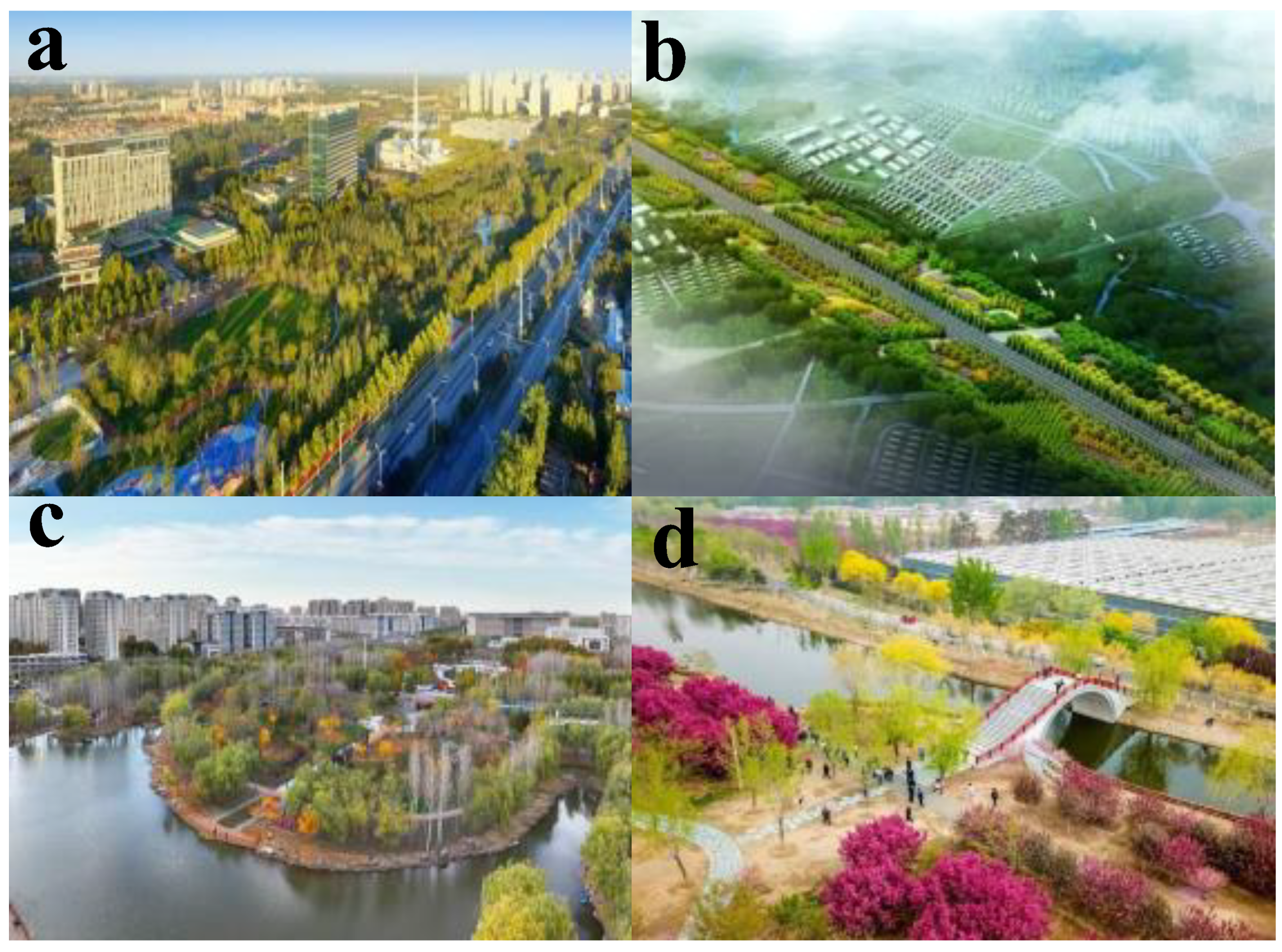
Figure 2.
Schematic diagram of the strategy for remediating ecological embankments.
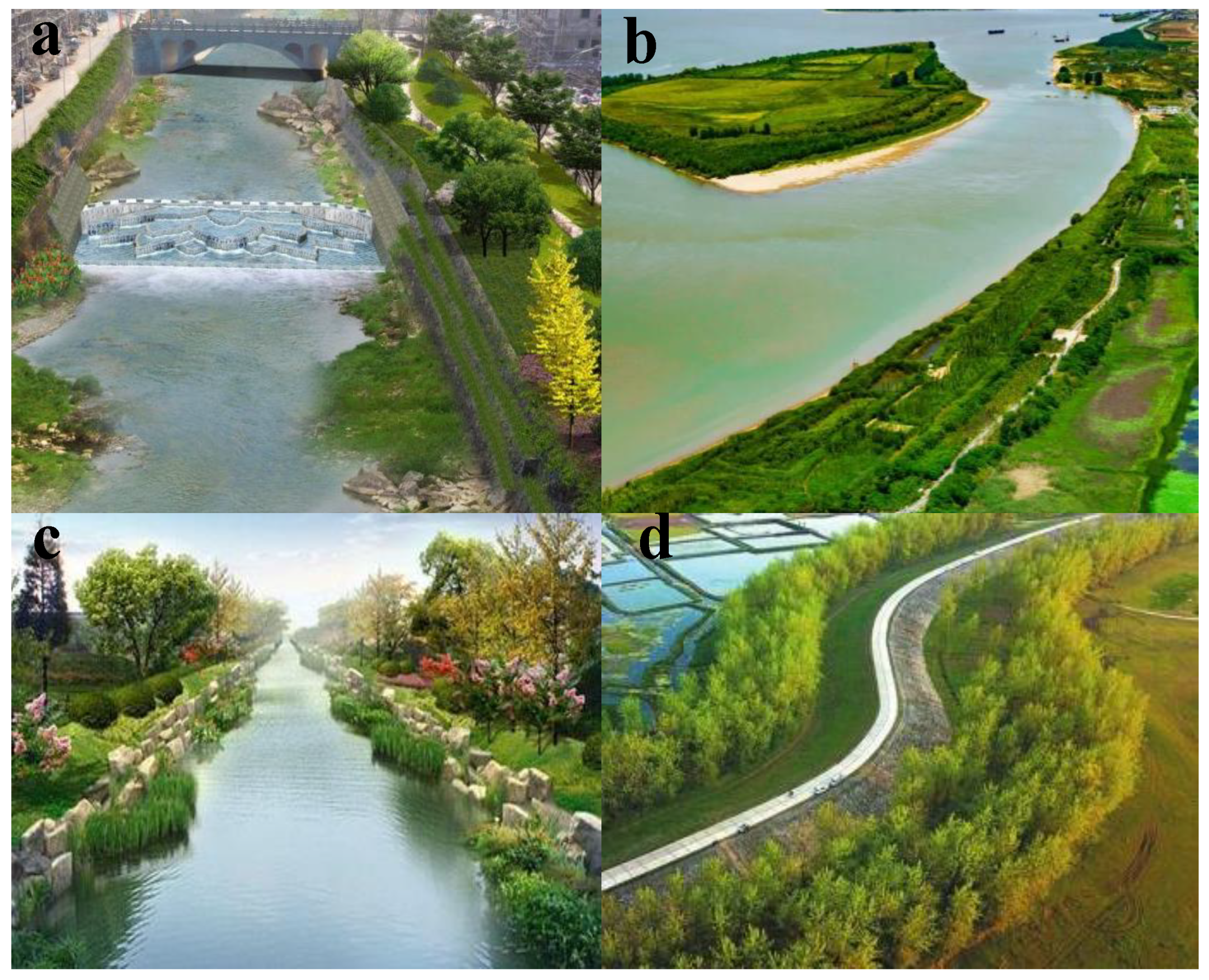
Figure 3.
Schematic diagram of the green belt around the city.
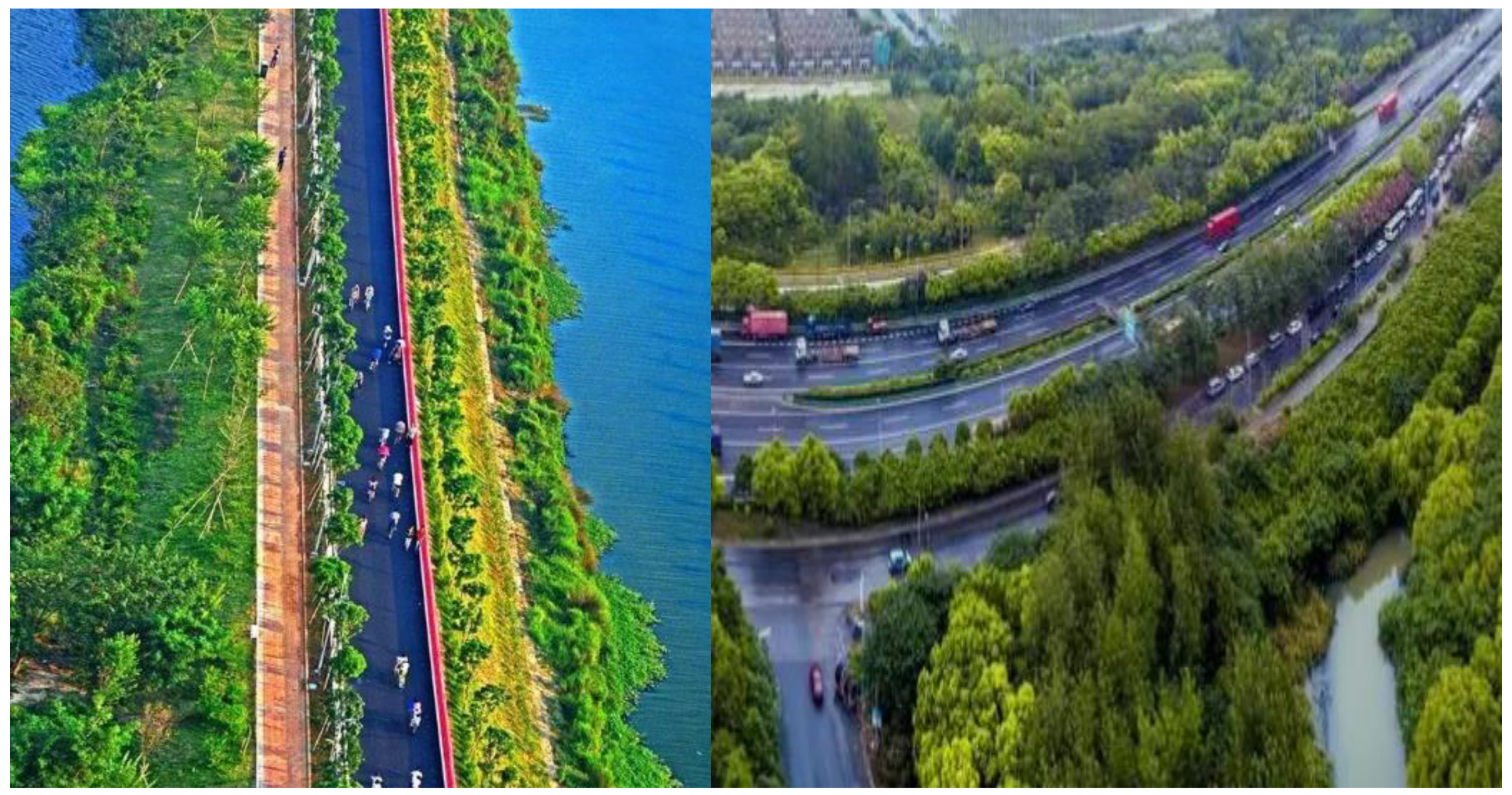
Figure 4.
Comparison of data acquisition time between traditional field surveys and remote sensing technology. (a) Acquisition time of traditional field survey data. (b) Remote sensing technology data acquisition time.
Figure 4.
Comparison of data acquisition time between traditional field surveys and remote sensing technology. (a) Acquisition time of traditional field survey data. (b) Remote sensing technology data acquisition time.
Figure 5.
Comparison of data acquisition errors between traditional field surveys and remote sensing techniques. (a) Error in obtaining traditional field survey data. (b) Remote sensing technology data acquisition error.
Figure 5.
Comparison of data acquisition errors between traditional field surveys and remote sensing techniques. (a) Error in obtaining traditional field survey data. (b) Remote sensing technology data acquisition error.
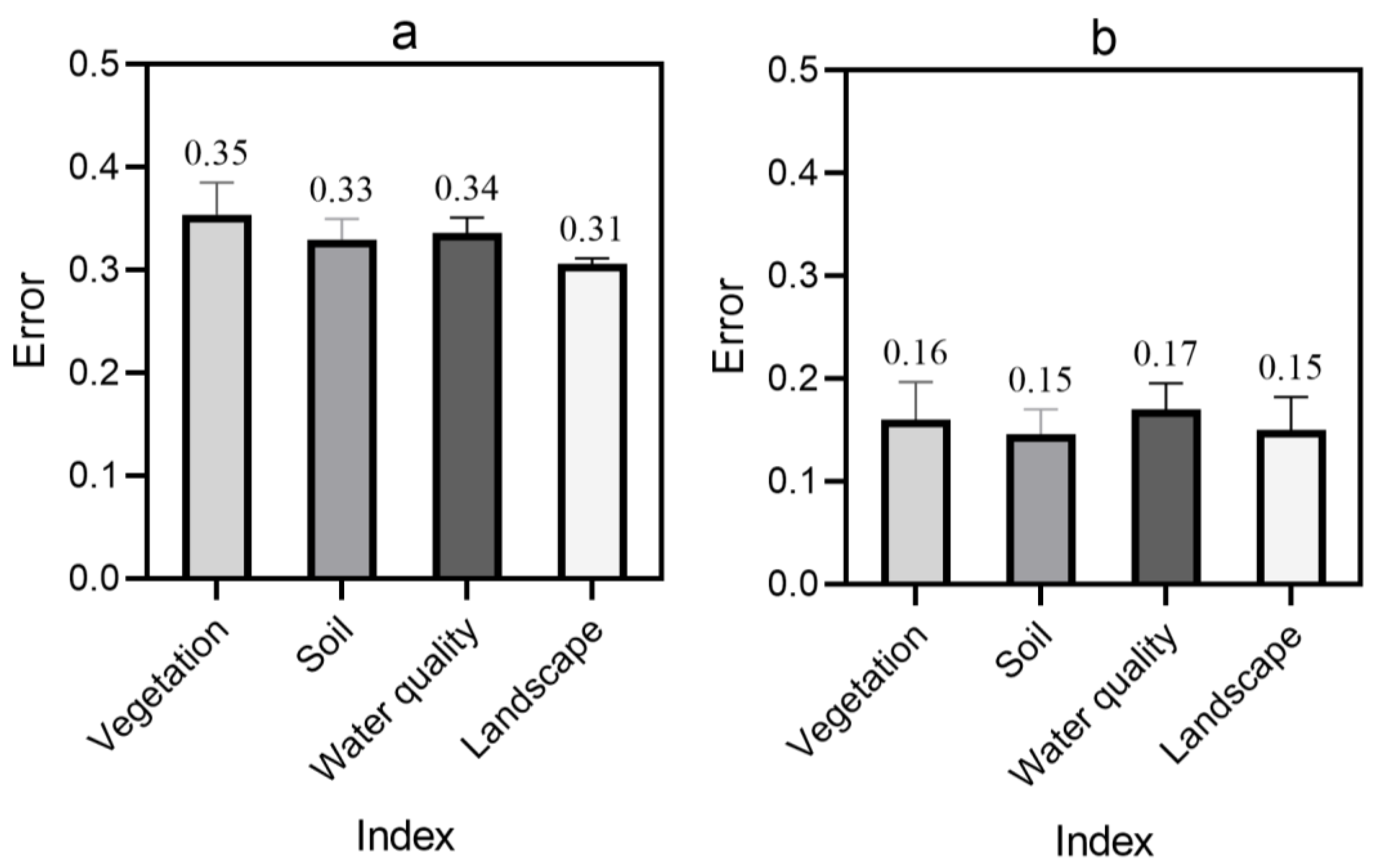
Figure 6.
Comparison of total suspended matter and chlorophyll content in waterscape 1-10 before and after planning. (a) Total suspended solids content before and after planning. (b) Chlorophyll content before and after planning.
Figure 6.
Comparison of total suspended matter and chlorophyll content in waterscape 1-10 before and after planning. (a) Total suspended solids content before and after planning. (b) Chlorophyll content before and after planning.
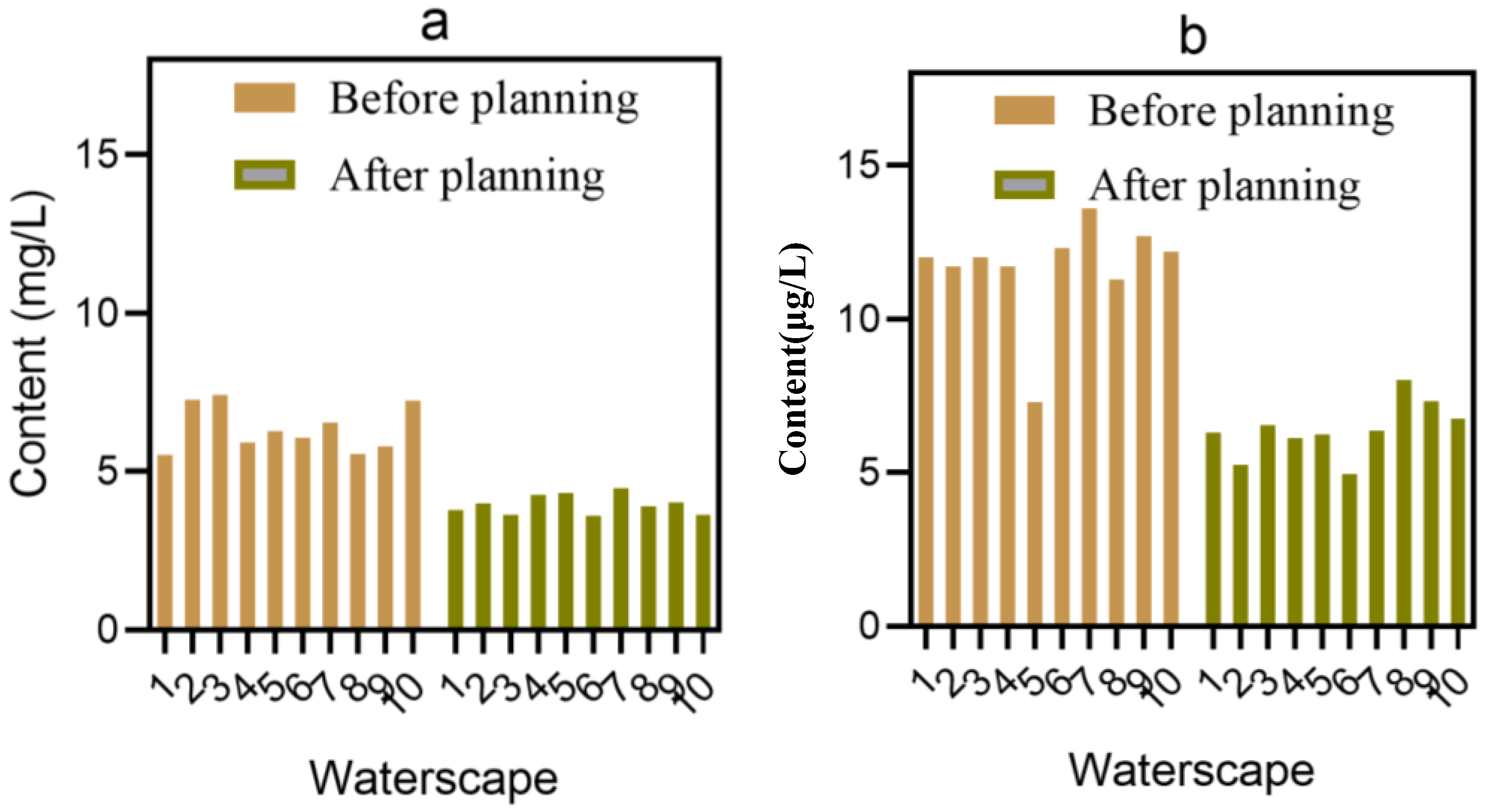
Figure 7.
Average public satisfaction score for regions 1-5 before and after planning. (a) Average score of public satisfaction in areas 1-5 before planning. (b) Average score of public satisfaction in areas 1-5 after planning.
Figure 7.
Average public satisfaction score for regions 1-5 before and after planning. (a) Average score of public satisfaction in areas 1-5 before planning. (b) Average score of public satisfaction in areas 1-5 after planning.
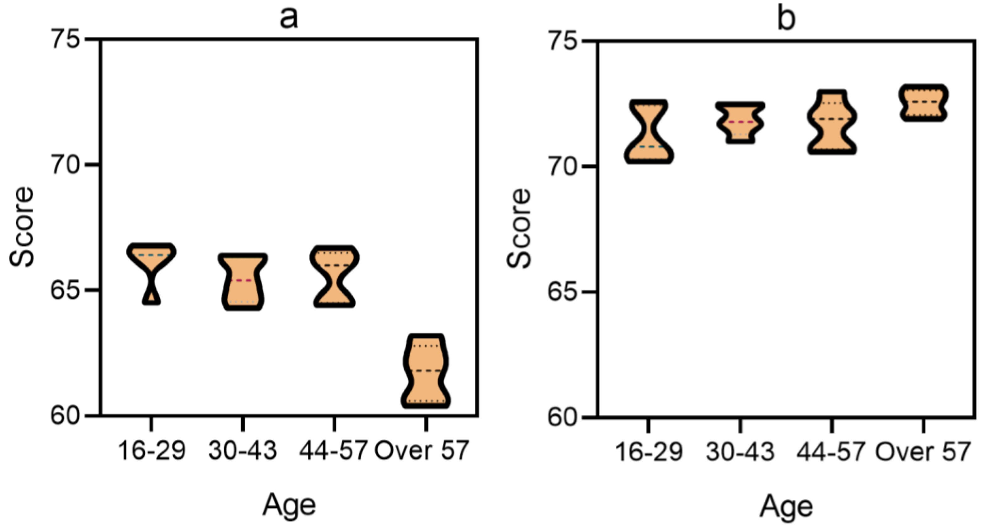

Table 1.
Comparison of monitoring data and actual data of remote sensing technology.
| Index | Vegetation coverage (%) | Available water resources (billion cubic meters) | Proportion of plain (%) | Per capita green park area (square meters) |
|---|---|---|---|---|
| Actual data | 47.25% | 7.74 | 98% | 13.93 |
| Monitoring data | 47.24% | 7.74 | 97.98% | 13.92 |
| Error | 0.01% | 0 | 0.02% | 0.01 |
Table 2.
Land use in areas 1-5 of Langfang City before planning.
| District | Road density (km/km²) | Building coverage (%) | Utilization rate of land resources (%) |
|---|---|---|---|
| 1 | 6.1 | 42.1 | 0.256 |
| 2 | 7.1 | 40.9 | 0.349 |
| 3 | 6.3 | 41.1 | 0.286 |
| 4 | 6.4 | 41.4 | 0.327 |
| 5 | 6.1 | 43.0 | 0.421 |
Table 3.
Utilization rate of 1-5 ecological landscape resources in Langfang City (%).
| District | Utilization rate of public green space (%) | Forest utilization rate (%) | Utilization rate of wetland (%) | Water utilization rate (%) |
|---|---|---|---|---|
| 1 | 15.7 | 15.6 | 13.1 | 15.5 |
| 2 | 15.5 | 15.1 | 11.9 | 16.4 |
| 3 | 13.8 | 16.1 | 13.7 | 15.1 |
| 4 | 14.4 | 15.4 | 10.7 | 14.3 |
| 5 | 15.2 | 14.4 | 11.2 | 16.6 |
Table 4.
Land use of Langfang city after ecological city planning.
| District | Road density (km/km²) | Building coverage (%) | Utilization rate of land resources (%) |
|---|---|---|---|
| 1 | 8.3 | 43.6 | 0.352 |
| 2 | 8.2 | 42.7 | 0.388 |
| 3 | 8.2 | 42.9 | 0.301 |
| 4 | 8.0 | 41.8 | 0.354 |
| 5 | 8.1 | 44.5 | 0.479 |
Disclaimer/Publisher’s Note: The statements, opinions and data contained in all publications are solely those of the individual author(s) and contributor(s) and not of MDPI and/or the editor(s). MDPI and/or the editor(s) disclaim responsibility for any injury to people or property resulting from any ideas, methods, instructions or products referred to in the content. |
© 2024 by the authors. Licensee MDPI, Basel, Switzerland. This article is an open access article distributed under the terms and conditions of the Creative Commons Attribution (CC BY) license (http://creativecommons.org/licenses/by/4.0/).
Copyright: This open access article is published under a Creative Commons CC BY 4.0 license, which permit the free download, distribution, and reuse, provided that the author and preprint are cited in any reuse.


