
Submitted:
06 August 2024
Posted:
07 August 2024
You are already at the latest version
Abstract
The viticulture sector, spanning over 7.3 million hectares worldwide, plays a crucial economic role but faces challenges such as labor shortages, rising production costs, market competition, and climate change stresses. Addressing these issues requires monitoring the spatial and temporal variability in vineyard productivity. Traditional ground-based observations, though accurate, are time-consuming and limited in scope. Precision viticulture, leveraging technologies like GPS, remote sensing, and artificial intelligence, offers efficient, non-destructive monitoring tools. This study aims to develop and test a technological workflow using the mobile app Digivit, integrated with the AgroSat platform, to estimate yield variability in vineyards. The workflow was performed during the 2023 growing season in a series of vineyards near Siena (Italy) and involved two main steps: spatial variability characterization using AgroSat and yield estimation using the mobile Digivit app. AgroSat processed Sentinel-2 NDVI data to identify homogeneous zones, while Digivit used smartphone images of grape clusters to estimate yields. The field campaign, performed three weeks before harvest, involved monitoring representative vines within identified zones and uploading georeferenced images for cluster segmentation analysis. Yield estimates were validated against measured weights, showing a strong linear correlation (R²=0.85, RMSE=43.74g). Excluding one outlier improved correlation to R²=0.95, RMSE=14.58g. Vineyard-level yield predictions were compared with harvest data, achieving an overall error of approximately 7%, in agreement with other methods in the literature. The study demonstrates that the Digivit app provides accurate, timely yield prediction, supporting farmers in harvest planning and winemaking management. The user-friendly mobile app approach facilitates a broader adoption of precision viticulture technologies among farmers, overcoming barriers related to technical expertise.
Keywords:
Precision Viticulture
; bunch segmentation
; image analysis
; Sentinel-2
; yield mapping
; vineyard management
1. Introduction
The viticulture sector is highly regarded for its significant economic impact, with a total area of over 7.3 million hectares worldwide for the production of wine and table grapes [1]. In this scenario, growers have to face many obstacles such as a lack of workers in agriculture, increased production costs, high market competition, climate change-induced variability in weather patterns, shortened seasons and drought [2,3]. To overcome these problems and identify the optimal vineyard management strategies, it is crucial to monitor the spatial and temporal variability in terms of vegetative and productive response which commonly affect viticultural systems [4].
Traditional ground observations and survey could be very accurate, but meanwhile time-consuming, which forces to a limitation in sampling or observation points, and consequently a lower efficiency in variability characterization [5]. The introduction of new technologies and methodologies strongly improved the monitoring efficiency with fast, non-destructive and objective tools able to provide a large-scale picture of soil and plant features variability. The aforementioned technological approach defined as Precision Viticulture takes advantage of innovative solutions such as global positioning systems (GPS), wireless sensor networks, satellite, airborne and Unmanned Aerial Vehicle (UAV) remote sensing, on-the-go proximal sensing, geographic information systems (GIS), geostatistical tools, smartphones with mobile applications, web-based platforms, artificial intelligence and learning algorithms and Decision Support System (DSS) [6].
To develop effective vineyard management strategies, it is necessary to harmonize the huge amount of data and translate digital numbers into agronomic information to be really comprehensible and effectively implemented by farmers. Despite digital technologies’ obvious use in agricultural management, their implementation is challenging due to several important constraints, such as lack of the necessary training or experience and/or graphical user interface of DSSs not always intuitive, therefore users may struggle to achieve their goals [7]. A range of smartphone applications has been created to meet the needs of farmers, with an emphasis on learning, diseases and pests, market data, weather data and forecasting, and field mapping. Given the increased number of applications in the agriculture sector, mobile devices have been shown to play a significant role in the diffusion of precision approaches. Among the precision viticulture applications and supporting tools, yield mapping and monitoring play a critical role in providing grape growers with real-time information during harvest or enabling efficient planning and management of production using spatial yield trends through pre-harvest monitoring, thereby improving overall crop productivity. Some authors reported experiences with the processing technique of manually taken images in the vineyard [8,9], with on-the-go systems [10,11] or using UAV platform [4].
In this context, the aim of this work was the development and testing of a technological and methodological workflow based on a mobile app solution to allow representative sampling of yield spatial variability in vineyards and generating yield maps for identifying areas of different productive potential.
2. Materials and Methods
The research was carried out during the 2023 vegetative season in 2 Sangiovese cv. vineyards trained with a vertical shoot positioning system for a total surface of 6.24 ha located near Siena in Italy.
The operational workflow was created in two steps using a digital system based on two technological platforms developed by the authors, i) in the first phase, a web-based DSS capable of characterizing the spatial variability of each vineyard was used, ii) subsequently a mobile app was used to acquire images of the fruiting zone to provide yield prediction. The first step of vineyard homogenous zone identification was accomplished using the AgroSat web-based open platform (www.agrosat.it) developed by CNR-IBE in 2016. This platform represents a free and accessible service designed to assist farmers in the effective management of their fields using a precision agriculture approach, through the adoption of open standards and the establishment of a Service-Oriented Architecture. This tool is available from any device.
The AgroSat platform, developed and deployed on the web, can seamlessly incorporate multiple components (such as satellite imagery, crop modeling, agro-weather predictions, management software, and territorial information systems), making them accessible to agricultural operators in a user-friendly and harmonized way, eliminating the need for multiple applications. Within this research, the main function of the AgroSat platform used was for the elaboration and visualization of Copernicus Sentinels-2 satellite reflectance data. Those data were processed to calculate NDVI maps able to characterize multitemporal variability of the vegetative status of plants within vineyards. As the second step, the functionalities of a prototype mobile app named Digivit were tested.
This tool was developed by the authors together with the technical support of the Yoo-No Lab company. The app is directly connected with the AgroSat platform and allows yield prediction by applying image analysis techniques on bunch images acquired in the vineyard with a mobile device. Figure 1 describes the research workflow based on the combined approach of AgroSat platform and Digivit app, which support the user in:
• visualization of NDVI maps elaborated and stored on the AgroSat server;
• visualization of sampling maps using K-means classification of NDVI values to drive the user to sampling zones;
• acquisition of RGB images of the bunches for sample vines within each management zone;
• upload image dataset to AgroSat server for data elaboration;
• visualization of yield estimation results per zone and vineyard.
In terms of agronomic management and winemaking, the winery divides each of the two vineyards into five parcels, resulting in ten production sub-units that are harvested independently. For this reason, the yield monitoring with the DIGIVIT app was carried out on 05 September 2023 (3 weeks before harvest) by managing the total surface of 6.24ha as 10 separate vineyards. Figure 2 reports some screenshots related to Digivit app functionalities in the in-field yield mapping. For each vineyard, the Digivit app allowed the identification of a series of sampling zones according to spatial variability, generally two zones per hectare in the higher and lower vigor area, and then, 5 representative vines were monitored within each zone. Subsequently, georeferenced images were uploaded on the AgroSat server either immediately in the field if there was an internet connection, or at the end of the survey via the closest available wi-fi.
The bunch segmentation and yield estimation, based on color thresholds on the red and blue channels and projected area for weighting calculation, were processed following the methodology suggested by the authors in previous work [4]. The method validation was made using 14 bunches, individually photographed using the Digivit app directly on the plant and subsequently cut and weighed. The average yield per vine calculated in each zone was then used to calculate the total yield per vineyard, employing a linear regression with the last available Sentinel-2 NDVI value of each sample zone.
The linear estimation model was then applied to elaborate a yield prediction map based on vigor spatial variability for each vineyard, identifying a yield prediction for each Sentinel-2 map pixel with different NDVI values. This step allows calculating the average yield per vine of each vineyard, which has been used to estimate the total yield per vineyard using the total number of vines, obtained by vineyard surface and vine spacing.
3. Results and Discussion
The validation analysis of bunch weight estimation made on 14 sample bunches is summarized in Table 1, which reveals a strong linear connection between the predicted and measured weight with R2=0.85 and RMSE=43.74 g. The assessment of the protocol compared to conventional ground measurements revealed a robust performance at the full ripening stage, several weeks before harvest.
Nevertheless, it is important to emphasize that when examining the outcomes of each bunch individually, one bunch weight (ID=6) was underestimated by 155 g because of a partially unripe condition, which led to an error in the segmentation process. Given the atypical nature of this condition in the pre-harvest period, the performance significantly improves upon eliminating this bunch, attaining an R2=0.95 and an RMSE=14.58 g. Subsequently, the segmentation results of the monitored bunches in areas representing spatial variability were combined to determine the average yield per plant in each zone. Then, by utilizing the linear correlation with satellite NDVI data, the yield for each vineyard was calculated.
Table 2 reports the results of the yield prediction calculated using the images acquired with the Digivit app and the yield measured by the farmer at harvest time for each of the study sites. The results obtained on the 10 experimental vineyards provided good performances of the proposed tool, reaching correlations of R2=0.84 and a value of RMSE=0.40 t per vineyard. In line with the previous analysis, the methodology provided lower performance in site A, characterized by some issues related to grape ripeness, as a consequence of a very wet season with a high incidence of downy mildew on both leaf and bunch level. However, comparing the overall yield estimated for all the vineyards with the values measured at harvest, a complex error of around 1.0 t can be observed, which corresponds to an underestimation of around 7% of the total grape production. This accuracy is similar to or better than other works in literature [4,10,11], ranging between 13% and 18% in yield prediction.
Considering that the yield prediction by the Digivit app was made 3 weeks before the harvest, the data obtained was extremely useful to the company, not only for planning the harvest but also for the management of the winemaking process. Cultivar factor affects cluster features, in terms of cluster morphology, berry color and cluster overlap level, consequently, future efforts would be aimed at investigating the methodology performance across different seasons and potentially identifying a seasonal coefficient to correct yield estimation.
Once this method has been refined and calibrated with other grapevine cultivars, it will be possible to quickly map large areas of tens of hectares, monitoring representative zones of vineyard spatial variability in terms of vigor. Moreover, this kind of approach allows to perform non-destructive, objective and repeatable measurements, without subjective error as in the case of visual evaluation of yield per plant, which commonly occurs even when farmers wish to avoid destructive and time-consuming measurements by applying automatic methods. As reported by Mendes et al. [12], standard smartphones are outfitted with a variety of sensors that have the potential to provide inexpensive near-real-time support for routine and advanced agricultural tasks. As a result, there has been a significant surge in the development of smartphone-based agricultural applications over the past few years.
4. Conclusions
Considering the previous approach suggested by the authors [4], this innovative solution doesn’t require any expertise in UAV remote sensing by the farmer. Many of the technological solutions of precision agriculture are far from the farmer's knowledge, which is a critical aspect in the diffusion of digital viticulture approaches. A strength of Digivit is related to the user-friendly approach of mobile technology, in fact concerning other traditional technologies such as remote or proximal sensing sensors, apps are the most appealing tools for farmers in terms of effortless use, universal accessibility, quick comprehension and potentially free from technical error. However, the enormous potential of agricultural apps has not yet been fully realized, also in viticulture. In this framework, the increased computing power of smartphones will lead a quick growth in the adoption of dedicated apps covering different management needs among farmer communities.
Author Contributions
Conceptualization, S.F.D.G. and P.T.; methodology, G.O.; software, L.R.; validation, S.F.D.G., L.P. and A.M.; formal analysis, G.O. and S.F.D.G.; data curation, S.F.D.G.; writing—original draft preparation, S.F.D.G. and R.D.; writing—review and editing, N.H., S.F.D.G. and R.D.; supervision, S.F.D.G. All authors have read and agreed to the published version of the manuscript.
Funding
This research received no external funding
Data Availability Statement
The data presented in this study are available from the corresponding author upon reasonable request.
Acknowledgments
The authors gratefully acknowledge Filippo Vigni (Castello di Ama) for having hosted and supported the experimental activities and Giacomo Piazzesi (YooNo-Lab) for Digivit app development.
Conflicts of Interest
The authors declare no conflicts of interest.
References
- Pisciotta, A., Barone, E., Di Lorenzo, R. Table-Grape Cultivation in Soil-Less Systems: A Review. Horticulturae 2022 8, 553. [CrossRef]
- Dhillon, R., Moncur, Q. Small-Scale Farming: A Review of Challenges and Potential Opportunities Offered by Technological Advancements. Sustainability 2023 15(21), 15478. [CrossRef]
- Koufos, G.C.; Mavromatis, T.; Koundouras, S.; Jones, G.V. Adaptive capacity of winegrape varieties cultivated in Greece to climate change: Current trends and future projections. OENO One 2020 54, 1201–1219. [CrossRef]
- Proffit, T., Bramley, R., Lamb, D., Winter, E. Precision Viticulture – A New Era in Vineyard Management and Wine Production. Winetitles Pty Ltd., Ashford, South Australia; 2006 1–90. ISBN 978-0-9756850-4-4.
- Di Gennaro, S.F., Toscano, P., Cinat, P., Berton, A. and Matese, A. A Low-Cost and Unsupervised Image Recognition Methodology for Yield Estimation in a Vineyard. Front. Plant Sci. 2019 10:559. [CrossRef]
- Matese, A, Di Gennaro, S.F. Technology in precision viticulture: a state of the art review. International Journal of Wine Research, 2015 7:69-8. [CrossRef]
- Lanucara, S., Praticò, S., Pioggia, G., Di Fazio, S., Modica, G. Web-based spatial decision support system for precision agriculture: A tool for delineating dynamic management unit zones (MUZs). Smart Agric. Technol. 2024 8, 100444. [CrossRef]
- Mack, L., Capezzone, F., Munz, S., Piepho, H.-P., Claupein, W., Phillips, T. D., Graeff-Hönninger, S. Nondestructive leaf area estimation for chia. Agron. J. 2017 109(5), 1960–1969. [CrossRef]
- Liu, S., Whitty, M. Automatic grape bunch detection in vineyards with an SVM classifier. J. Appl. Log. 2015 13(4), 643–653. [CrossRef]
- Aquino, A., Millan, B., Diago, M. P., Tardaguila, J. Automated early yield prediction in vineyards from on-the-go image acquisition. Comput. Electron. Agric. 2018, 144, 26–36. [CrossRef]
- Font, D., Tresanchez, M., Martínez, D., Moreno, J., Clotet, E., Palacín, J. Vineyard yield estimation based on the analysis of high resolution images obtained with artificial illumination at night. Sensors 2015 15(4), 8284–8301. [CrossRef]
- Mendes, J., Pinho, T.M., Neves dos Santos, F., Sousa, J.J., Peres, E., Boaventura-Cunha, J., Cunha, M., Morais, R. Smartphone Applications Targeting Precision Agriculture Practices—A Systematic Review. Agronomy-Basel 2020 10, 855. [CrossRef]
Figure 1.
Data processing workflow.
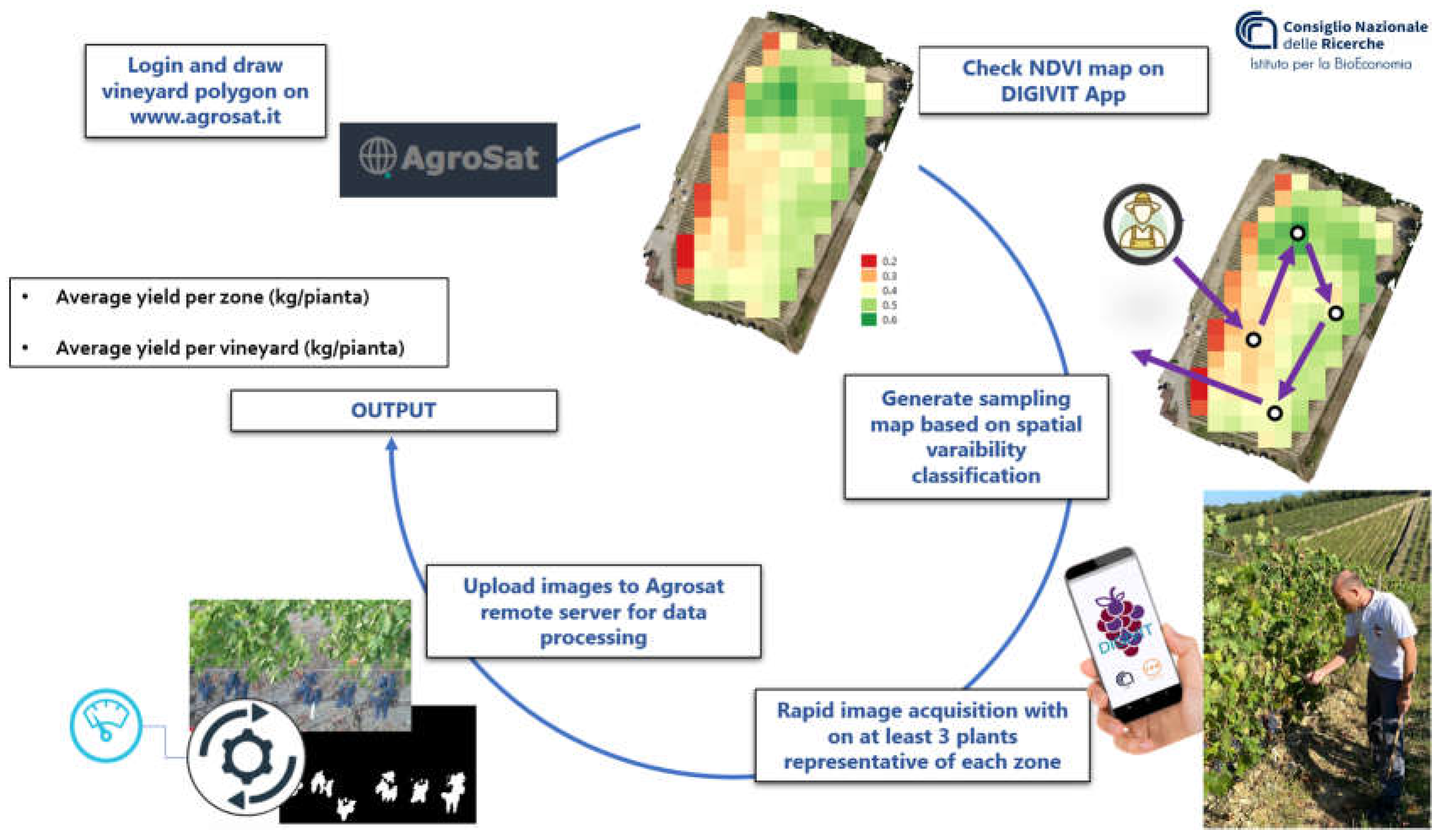
Figure 2.
Screenshots of the DIGIVIT mobile app related to the home section, sampling points map and bunch image captured in the field.
Figure 2.
Screenshots of the DIGIVIT mobile app related to the home section, sampling points map and bunch image captured in the field.
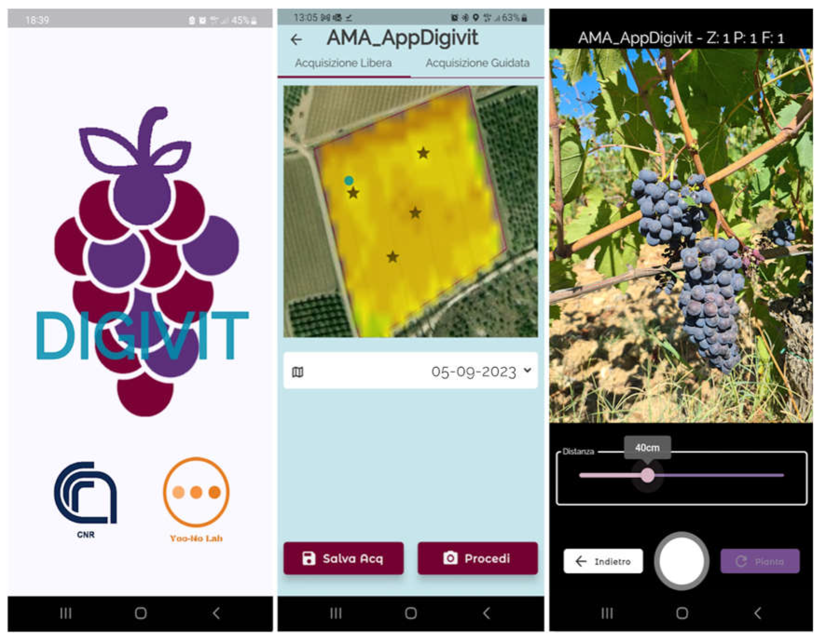

Table 1.
Validation of the Digivit app tool in yield estimation on sample bunches.
| Bunch ID | Bunch weight measured (g) | Bunch weight estimated (g) | error (g) |
|---|---|---|---|
| 1 | 182 | 193 | 11 |
| 2 | 208 | 228 | 20 |
| 3 | 85 | 96 | 11 |
| 4 | 290 | 277 | -13 |
| 5 | 166 | 148 | -18 |
| 6 | 462 | 307 | -155 |
| 7 | 188 | 206 | 18 |
| 8 | 123 | 92 | -31 |
| 9 | 99 | 91 | -8 |
| 10 | 258 | 243 | -15 |
| 11 | 86 | 86 | 0 |
| 12 | 192 | 195 | 3 |
| 13 | 146 | 140 | -6 |
| 14 | 109 | 106 | -3 |
Table 2.
Results of yield estimation using the Digivit app calculated at vineyard scale
| Vineyard ID |
Area (ha) | yield (kg/vine) | yield measured (t/vineyard) | yield prediction (t/vineyard) | error (t) |
|---|---|---|---|---|---|
| A | 0.79 | 0.52 | 2.44 | 1.50 | -0.94 |
| B | 1.38 | 0.53 | 3.57 | 3.41 | -0.16 |
| C | 1.14 | 0.49 | 2.27 | 2.59 | 0.32 |
| D | 0.47 | 0.50 | 1.36 | 0.99 | -0.37 |
| E | 0.04 | 0.73 | 0.05 | 0.13 | 0.07 |
| F | 0.50 | 0.62 | 2.00 | 1.45 | -0.55 |
| G | 0.53 | 0.57 | 1.16 | 1.18 | 0.02 |
| H | 0.55 | 0.56 | 1.30 | 1.29 | -0.01 |
| I | 0.56 | 0.75 | 1.11 | 1.47 | 0.36 |
| L | 0.29 | 0.75 | 0.70 | 0.84 | 0.14 |
| Total yield (t) | 15.96 | 14.85 |
Disclaimer/Publisher’s Note: The statements, opinions and data contained in all publications are solely those of the individual author(s) and contributor(s) and not of MDPI and/or the editor(s). MDPI and/or the editor(s) disclaim responsibility for any injury to people or property resulting from any ideas, methods, instructions or products referred to in the content. |
© 2024 by the authors. Licensee MDPI, Basel, Switzerland. This article is an open access article distributed under the terms and conditions of the Creative Commons Attribution (CC BY) license (http://creativecommons.org/licenses/by/4.0/).
Copyright: This open access article is published under a Creative Commons CC BY 4.0 license, which permit the free download, distribution, and reuse, provided that the author and preprint are cited in any reuse.


