Preprint
Article

Suburban Public Open Space – Types of Gathering and Recreation Places Developed under Mature Urban Planning. A Case Study of Bunnik Commune, the Netherlands

Altmetrics

Downloads

90

Views

44

Comments

0

This version is not peer-reviewed

Submitted:

08 August 2024

Posted:

09 August 2024

You are already at the latest version

Alerts
Abstract
The sustainable development of public open spaces (POS) in suburban areas is crucial to enhancing neighborhood livability, especially in the face of uncontrolled urban sprawl. Therefore, the question was asked: what forms of gathering and recreation places are in suburbs that are subjected to mature urban planning? The research focuses on the Netherlands (Bunnik commune), a country known for its sustainable suburban areas. By conducting field research that involved analyzing physical traces and engaging in non-participatory observation, the study identified and categorized 18 distinct spatial-functional units of POS looking from a top-down design and planning lens. The types of gathering and recreation places identified through top-down development included: estates with recreational areas for neighbors; communal playgrounds; greenery sites by pedestrian routes; social places in central zone; open sports grounds; public allotment gardens; multi-purpose recreational areas at schools, communal facilities generating informal meetings. POS types created as a result of both top-down and bottom-up development were: entrance zones to public facilities with a social value; viewpoints accompanying pedestrian routes; network of green walks for recreation in rural and natural landscapes. Other POS types (resulting from bottom-up development): diner's garden and urban farm.
Keywords: 
Subject: Environmental and Earth Sciences  -   Other

1. Introduction

During the internship in the Netherlands at the municipality of Utrecht, the author had the opportunity to experience the mature approach (that means: multidimensional, forward-thinking, participatory, and sustainable) taken in spatial planning there. In conversations with the authorities of one of Utrecht's suburban municipalities, Bunnik, the author had the same impression. In recent years, open public spaces (further: POS) in suburbs have become an important field of study for the author. In the course of her studies, she posed a question: what forms of POS in suburbs can be developed under mature spatial planning? Separation of top-down design and planning undertaken by government institutions, local governments or developers responsible for the housing estates development from those bottom-up undertaken by residents, resulted from several reasons. Top-down and bottom-up POS development differ not only in terms of legal basis and type of financing, but also in terms of path for initiating these activities. A typological exploration of POS suburbs (as in the case study of the Bunnik municipality) in terms of top-down POS development under mature spatial planning will offer a closer look at the framework for building the quality of suburban POS in this way.
As a result, this study was designed. It focused on gathering and recreational places located in the public spaces of the chosen suburban municipality in Netherlands1. The character of these places was identified by conducting their typological classification as a well-proven cognitive tool (Nochian et al., 2015).
Many authors use the typological categorization process to explore the phenomenon of POS. These studies differ in the type of perspective from which the proposed division is presented:
morphological form of POS related to its urban function
ownership and control over POS
social environment
natural environment
multi-faceted categorization.
The first approach takes into account the morphological form of POS related to its urban function. The authors focus here on creating spatial-functional units of sites and places included in POS (Gehl & Gemzøe, 2001). To narrow the scope, the specific function, e.g. recreational, is also taken into account in this approach, often combined with the availability (Classification Framework for Public Open Space. Healthier, Happier and Safer Communities., 2012; Gehl, 2011) In a broader sense, the authors propose a typology of POS in a case of its urban functions in the city system (Jałowiecki, 2010). Looking at the physical and structural side of POS, the authors categorize it also in terms of relationship between “green” and “gray” urban space (Al-hagla & Al-hagla, 2008; Stanley et al., 2012)
Many authors expand the issue of POS accessibility and relate it to the type of oversight over the area, and thus exercising control over it. This generates further types of typologies. POS is classified in terms of the ownership rank of the area on which it is located (government/urban/ community space) (Gulick, 1997). Other divisions result from the social nature of POS. They take into account the type of public access to space, dividing it into public, semi-public and private (Gachowski, 2008; Mantey & Kępkowicz, 2018; Parysek, 2011; Van Melik et al., 2007) In expanding the idea of control, the authors also draw attention to forms of social self-regulation (Van Melik et al., 2007) and further on, to accepting/not accepting social values or certain groups of users and creating boundaries and barriers for them (Malone, 2002). Finally, the authors point to tactics implemented depending on the degree of refusal, (Flusty, 2021) and even denying the right to participate, up to the point of creating a “geography of exclusion” (Sibley, 1995).
Another authors take on the topic POS exploration through a typological classification process includes social environment. Here, they include, among others:, social involvement in managing and modeling public space (Dines et al., 2006). When analyzing POS as a reflection of this issue, the authors divide sites into domains of different social sectors or interest groups (Carmona, 2010). On the other hand, the authors also consider the impact of space on social activities and interactions (Cattell et al., 2008; Gehl, 2011) Other divisions take into account the social utility of different sites (Alexander et al., 1977; Kępkowicz, 2019), even categorization of public spaces of homelessness (Parker, 2021). The social dimension of space is also recognized through cultural-semiotic perspective, taking into account the forms of spatial order and social status perceived by POS users (Majer, 2010).
Many publications categorize public space in terms of nature. The authors analyze the character of POS in terms of the physical morphology of the area and plant cover, both natural and arranged (Nochian et al., 2015). Taking into account the latter aspect – the developed green areas – the authors categorize them in terms of recreational and health-promoting functions (Piątkowska, 1983; Szumański, 2005). And finally, divide POS in terms of the ecological importance of public space (Fieldhouse, 2002).
In addition to typologies focused on specific attributes or POS determinants, there are also multi-faceted approaches: combines ownership, accessibility and intersubjectivity (Kohn, 2021) and function, perception and ownership of the area (Carmona, 2010). In turn, other author categorizes POS into six spheres related to the usability of POS: structural, economic, natural, recreational, social and cultural (Kępkowicz, 2019) .
Taking into account the main topic of this publication: exploration of the suburban POS, authors fit into all four approaches presented above, although not always to the same extent. The most frequently undertaken approach is the social one. Here, typological divisions concern forms of semi-public spaces (Mantey & Kępkowicz, 2018), the variety of suburban forms according to the degree to which they favor the creation of public spaces (Mantey & Sudra, 2019), the “publicness” of suburban gathering places (Mantey, 2017), usability for the local suburban community (Kępkowicz, 2019) and “third places” of suburbia (Kępkowicz et al., 2019). The next four perspectives on POS exploration of suburbia concern spatial-functional units of POS (Alexander et al., 1977) (Kępkowicz, 2019) (Francis & Griffith, 2011), forms of ownership and control of POS in terms of stakeholders' cooperation for place making (Huang et al., 2020) as well as typology of suburban landscape values (Solecka et al., 2022), as well as a multi-criteria POS classification of suburbs in terms of urban, natural and social determinants (Kępkowicz, 2019).
The presented research fits into existing study paths shown above: a typology of spatial-functional forms of POS and the type of ownership and control over POS. On the other hand, the discussed research problem complements the scientific knowledge gap pointing to the types of POS in suburbs developed through top-down design and planning.
The presented research fits into following existing study paths as shown above: a typology of spatial-functional forms of POS and the type of ownership and control over POS. On the other hand, the discussed research problem complements the scientific knowledge gap pointing to the types of POS in suburbs developed through top-down design and planning.

1.1. Bunnik Municipality as the Object of a Field Study

The case study was carried out in an independent administrative and territorial unit, a municipality, which is itself a “urban organism”. The municipality had the characteristics of a classic suburb, the essence of which, despite differences, is still characterized as “bedroom community” (Dinic & Mitkovic, 2016) created by numerous housing estates with lower building intensity than in a city, where their residents still benefit from the cultural resources and labor markets of the large “parent” agglomeration and take the advantage of open areas with their natural and rural surroundings. (Airgood-Obrycki et al., 2021; Davidson, 2013; Harris, 2015; Kępkowicz & Mantey, 2016; Muminovic & Caton, 2018).
The selection of Bunnik Municipality, located in Utrecht agglomeration (the Netherlands), was influenced by several reasons beyond meeting the previously mentioned conditions. One of them was the recognition earned by the participation and efficiency of planning teams in their urban and rural development. Another reason was the solid background provided by the long-standing tradition of well-planned and innovative built environments in suburban areas noted in the Netherlands (Lörzing, 2006). Furthermore, the Dutch gathering and recreation places point to high standards in the creation of “urban products” (Harris & Lehrer, 2018). Hall even asserts that in terms of best practices in creating sustainable urban and suburban areas, the Netherlands is the undisputed European leader (Hall 2021a). These opinions align with the author's impressions from research trips to Dutch suburbs, undertaken between 2011 and 2020.
The high quality of residential space in the Netherlands suburbs is not accidental. The success of today's POS standard in the Dutch suburban towns is the result of a series of previously implemented strategic plans based on the idea of a residential space integrated not only in terms of development, but also socially and ecologically. Among the main strategies and development polices realized since the 1970s were: the "Growth Centers" program, the Vierde Nota Ruimtelijke Ordening Extra "VINEX; NOTA RUINTE development policy, or the DEED (Buckenberger, 2015; Galle & Modderman, 1997; Hall, 2021; Visser et al., 2009).
As a result, contemporary Dutch suburbs have become a common and attractive living space (Karsten et al., 2013). In recent years, the Netherlands has taken further steps to increase the efficiency of its efforts in this field. The country introduces market-based values such as competition, efficiency and flexibility into its “regulatory” spatial planning system (Remøy & Street, 2018)
The selection of the Bunnik commune was also influenced by the diversity of natural, historical, and urban conditions (described in detail in RESULTS, 3.1. Study area), expressed by:
Diverse histories of the country towns belonging to the commune
Varied landscapes (urbanized, rural, natural)
Diversity of settlement forms, ranging from the most frequent single-family housing estates to multifamily housing estates, and farms
Presence of public utility facilities, including service-commercial, educational, sports, and social functions, both of local and supra-local importance
Varied forms of greenery (e.g., urban green spaces, agricultural areas, waterfront and forested areas)
Diverse forms of mobility, including wide accessibility for pedestrians and cyclists to open areas within three zones of reach: central, local, and peripheral.

1.2. Gathering, and Recreation Places as a Public Space Consumed and Co-Created by the Local Community

The subject of the research was publicly accessible public open space (POS) located in an urbanized and/or natural space and meeting the social needs of residents (Bravo & Crawford, 2014; Kępkowicz, 2019). The focus was on accessibility for pedestrians and bikers especially in relation to residential areas (McCormick, 2016). It appears to be important because it meets the needs of residents who “seek an experience and want to engage and be social with others” (McCormick, 2016). The importance of such places has been emphasized in numerous publications, including the in classic: "A Pattern Language" (Alexander et al., 1977), "How to Turn a Place Around?" (Madden et al., 2010) or “The Great Good Place […]” (Oldenburg, 1989).
Nowadays, it is not only the general social function of these places that is becoming a concern (Horrigan, 2019; Tao et al., 2022; Worpole & Knox, 2007) but also whether they are inclusive (support place making) (Basu & Fiedler, 2017) The concern is also whether these places make our neighborhoods livable and pleasurable (Eriawan and Setiawati 2017; Kępkowicz 2019; Martinuzzi and Lahoud 2020; Praliya and Garg 2019; Project for Public Spaces 2016; Woolley et al. 2003) with noticeable outdoor comfort (Ma et al., 2021; Peng et al., 2021).
The aforementioned gathering places will be understood in this publication as a forum for various human interactions. These can be casual, when people are connected only by staying in the same space, also known as a “gather and stare” (StoneCreek Partners, 2015). They can also be spiritual, dedicated to contemplation of oneself or of nature, or they can be “urban park leisure” (Tao et al., 2022). They can also be dedicated to joint and committed participation in an activity (Madden et al., 2010). Asking a passer-by for directions or travel time, a conversation between a clerk and a customer, a joint bike ride, a collective tai-chi practice, a public political speech, or any group activity that is considered frivolous, when relaxation encourages contact, can be classified as a gathering (Goffman, 1966). Gathering places could be squares, parks, gates, streets, cafe gardens, gateways to public facilities or shops (Alexander et al., 1977; Madden et al., 2010). There are also gathering places that are difficult to access for some, but used by others, e.g., forest clearings or abandoned construction sites where young people often meet (Kępkowicz & Mantey, 2016). Also, these places include spaces that were not strictly public, but semi-private, club type – e.g., sports clubs (Kępkowicz et al., 2014).
Recreation will be understood in the classical sense as “any form of play, amusement, etc. used for refreshment of body or mind” (Veal, 1992) (p.7). The places of recreation are areas where this kind of activities are carried out individually or in groups for personal satisfaction and pleasure (Bell et al., 2001). They are voluntary, internally motivated, and not related to work or other obligations (Veal, 1992). This means they include activities such as plays, sports games and qualified sports (Bell et al., 2001), as well as more passive leisure, involving extensive activity or no activity at all (Veal, 1992).
Nowadays, the social trends take into account not only spaces that are obviously and traditionally considered public: squares, playgrounds, or shopping streets (Alexander et al., 1977; Carmona, 2022; Madden et al., 2010), but spaces that are perceived as “everyday space” (Chase et al., 1999). This meant considering also the non-obvious places, e.g. undefined public spaces appropriated by residents for common purposes (Bravo & Crawford, 2014) and which bore the hallmarks of gathering and recreation functions. These were spaces of all kinds, from public to semi-public, to private – e.g., home gardens made accessible to residents and tourists (Mantey & Kępkowicz, 2018, 2020).
Upon exploring gathering and recreational places, it becomes noteworthy that they come into existence through both top-down and bottom-up actions (Huang et al., 2020; Kępkowicz, 2019).
In summary, it was assumed that due to the aforementioned conditions, in the Bunnik commune there are various forms of public open space (POS), which merge to create diverse spatial-functional forms. The research then focused on identifying gathering and recreation places located in the public space of this suburban commune and subsequently exploring them by conducting their typological classification. The key focus was to refer the resulting types to top-down suburban development.

2. Research Design and Methods

Indicating POS types in Bunnik commune that were the result of top-down development required an appropriate research methods. Since the study object was the existing POS, an inductive approach was adopted.
The research was conducted in three stages:
STAGE 1: Selection of the research method for classification of gathering and recreation places.
To identify and characterize the POS types of the Bunnik commune the “POS Spheres Method” was selected (Kępkowicz, 2019). It was considered suitable for obtaining a typological division in the current study because:
  • It focuses on the exploration of existing local gathering and recreation places.
  • It offers a division of observed places by capturing them as spatial-functional units
  • Utilizes survey instruments (mainly analyses of physical traces, non-participatory observation, and analysis of hedonic quality of space) that allow the identification of a variety of relations in the spatial-functional arrangement of the studied places.
  • The POS spheres method takes into account urban, natural, and social determinants of POS development and represents an interdisciplinary approach to the study of public space that captures the structural, economic, natural, recreational, social, and cultural aspects of POS.
STAGE 2: Identification of existing gathering and recreational places as spatial-functional units carried out in the Bunnik commune using the “POS Spheres Method”.
Since the indicated “POS Spheres Method” (Kępkowicz, 2019) is not available in English, the crucial points of this method were summarized and made available in the dataset repository: Kępkowicz, Agnieszka (2023), “METHOD FOR CREATING PUBLIC OPEN SPACE TYPOLOGY IN LINE WITH THE IDEA OF PLACE-MAKING”, Mendeley Data, V1, doi: 10.17632/485rgf2kdv.1.
The research of this stage comprised the following:
(a)
A preliminary study to analyze the urban background of the commune, including:
Indication of landmarks based on iconographic analysis of online sources (OpenStreetMap, n.d.)
Indication of the location of communication hubs for each of the villages of the Bunnik commune and the public buildings (educational, health, cultural and sacral centers, the local government office, shopping centers and supermarkets)
Analysis of the communication system with particular emphasis on the course of communication arteries (OpenStreetMap, n.d.)
Indication of the access zones for pedestrian traffic (Villanueva et al., 2015) for each of the villages of the Bunnik commune (central, local and peripheral zone)
Analysis of the landscape character based on analysis of photo documentary, cartographic and online resources (Google Maps, n.d.)
(b)
Distinguishing the gathering and recreation places (so called: POS objects) located in the commune and characterizing them based on the criteria and principles described in the dataset repository (POS sphere diagrams were deposited for each of them)
(c)
Combining the identified POS objects into groups (so called: POS types).
(d)
Developing characteristics of POS types in tables (Appendix A) of the scope described in the dataset repository (including development of POS sphere diagrams)
(e)
Discussing the POS types obtained as a result of the research.
STAGE 3: Presenting the characteristics of each POS type, taking into account top-down design and planning:
(a)
Analysis of POS types for top-down design and planning based on spatial-functional analysis of POS objects and land ownership.
(b)
Indicating forms of top-down design and planning
(c)
Development of the resulting characteristics of POS types supplemented by the set of diagrams of POS spheres (Appendix B), photos of exemplary POS objects that represent a given type, as well as structural models that describe it (Appendix C).
(d)
Compiling a of POS types in terms of top-down design and planning. The presented types were ordered by taking into account the quantitative share of POS objects in each type.

3. Results and Discussion

The research, both field and desktop, was conducted in 2018-2023. The results first outline the characteristics of the study area in question.

3.1. Study Area

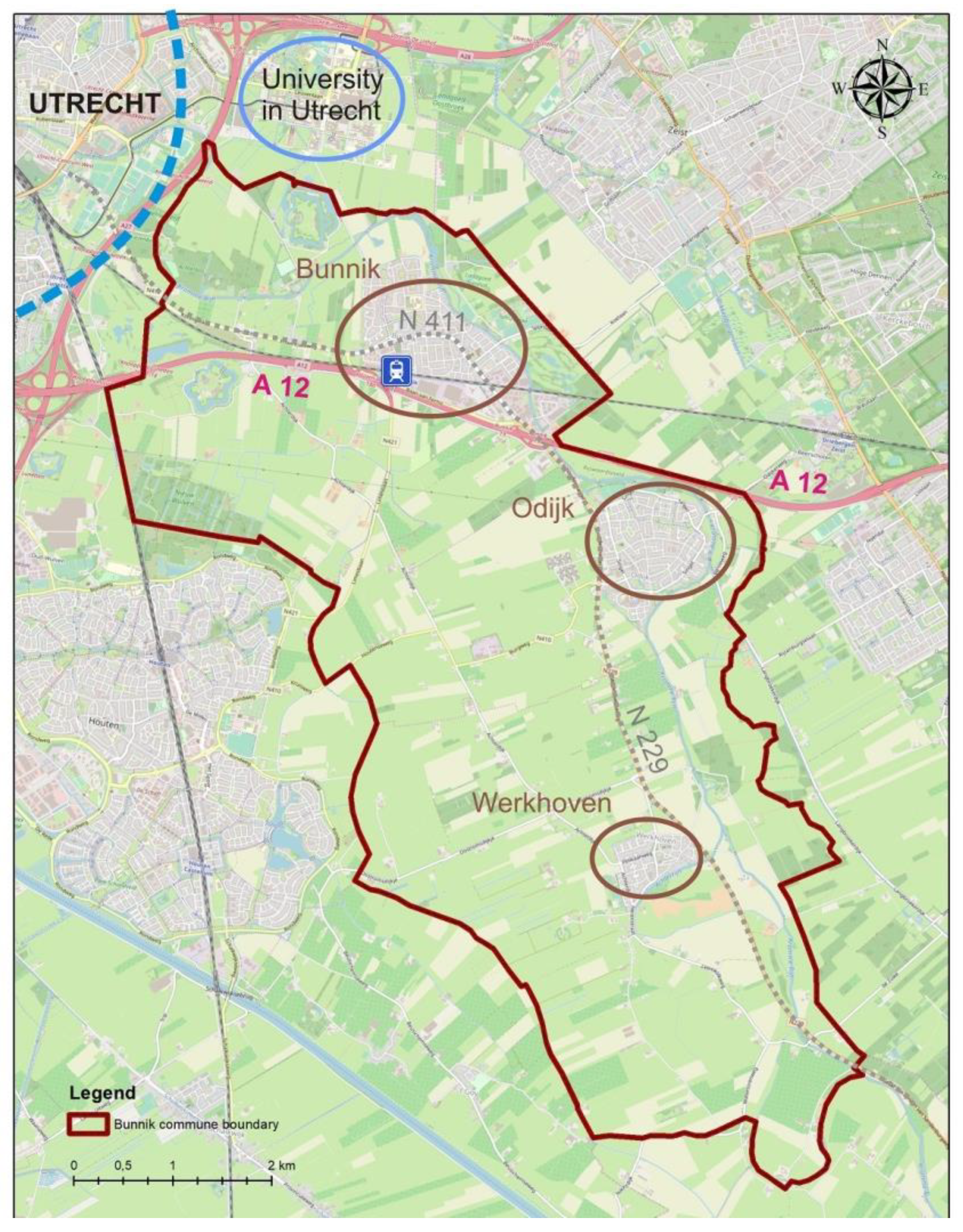
The area of the Bunnik commune (Figure 1.) was not formally included in the previously described Dutch development strategies. However, echoes of the planned suburban development of the 1970s based on "growth centers" have reached here as well. This also applies to later programs, e.g. VINEX and Nota Ruimte, which shifted the decision-making process to local level to better match the result to local conditions. The "Vinex district” has become a catchphrase, synonymous with new and modern large-scale construction projects. Such "Vinex estates" can be found in all three towns of the Bunnik commune.
In terms of development, the study area includes single-family housing estates as well as several multi-family housing estates in each community town. The estates are usually arranged as areas of fenced private properties with a public common area. Also, each town offers extensive sports and recreational areas. Please note that there are no gated communities in the Bunnik commune.
The largest town in the commune is Bunnik, which has also the most developed commercial and service area, but it is Odijk that is home to the Municipal Office. Werkhoven is the most intimate of the mentioned towns. In Bunnik and Werkhoven, the architecture is rather traditional (Werkhoven has a mini old town), and in Odijk it is much more modern.
The suburban commune Bunnik borders Utrecht agglomeration on the south-east. Although Utrecht is a medium-sized city (population ca. 300,000), it is an important scientific center, with the University of Utrecht and a metallurgical and engineering plant hub.
It is also a tourist destination and an important road junction (roads: A2, A27, A28 and A12 motorway, which leads west to Utrecht and east to Arnhem). The communication system of the Bunnik commune is based on the N229 road and its northern extension, the Provincialeweg (route N411).
A significant share of open agricultural and forest areas, as well as a number of historic buildings (Landgoederij in Bunnik, the 19th-century old town in Werkhoven and several historic churches), made the commune an attractive place to live for over 14,000 residents. The largest increase in the commune’s population was recorded in the mid-1960s and 1970s.
The commune's landscape comprises town-like development, with distinctly separated agricultural and natural areas (forest and waterside), and sparsely located farms.

3.2. Distinguishing of the POS Objects

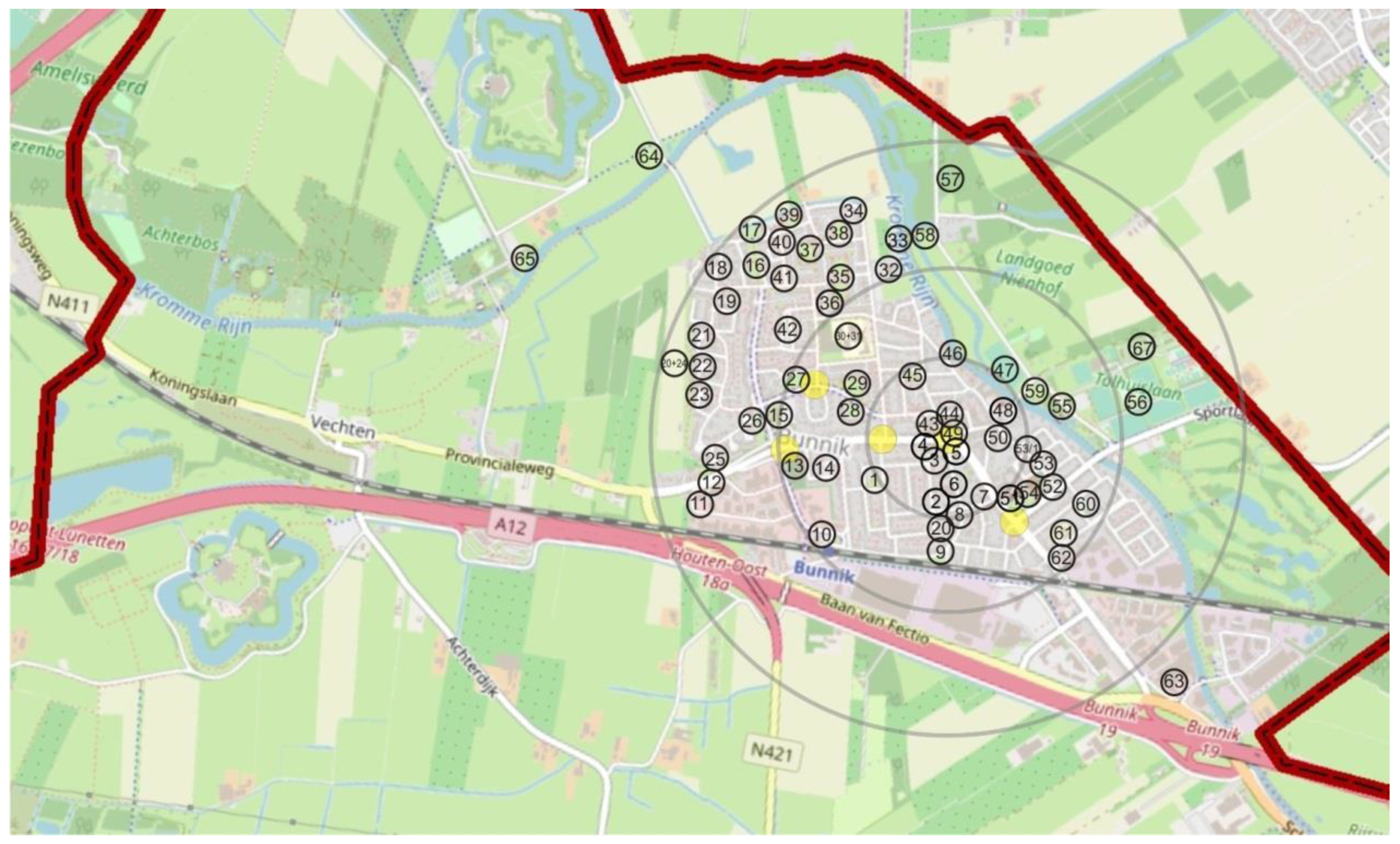
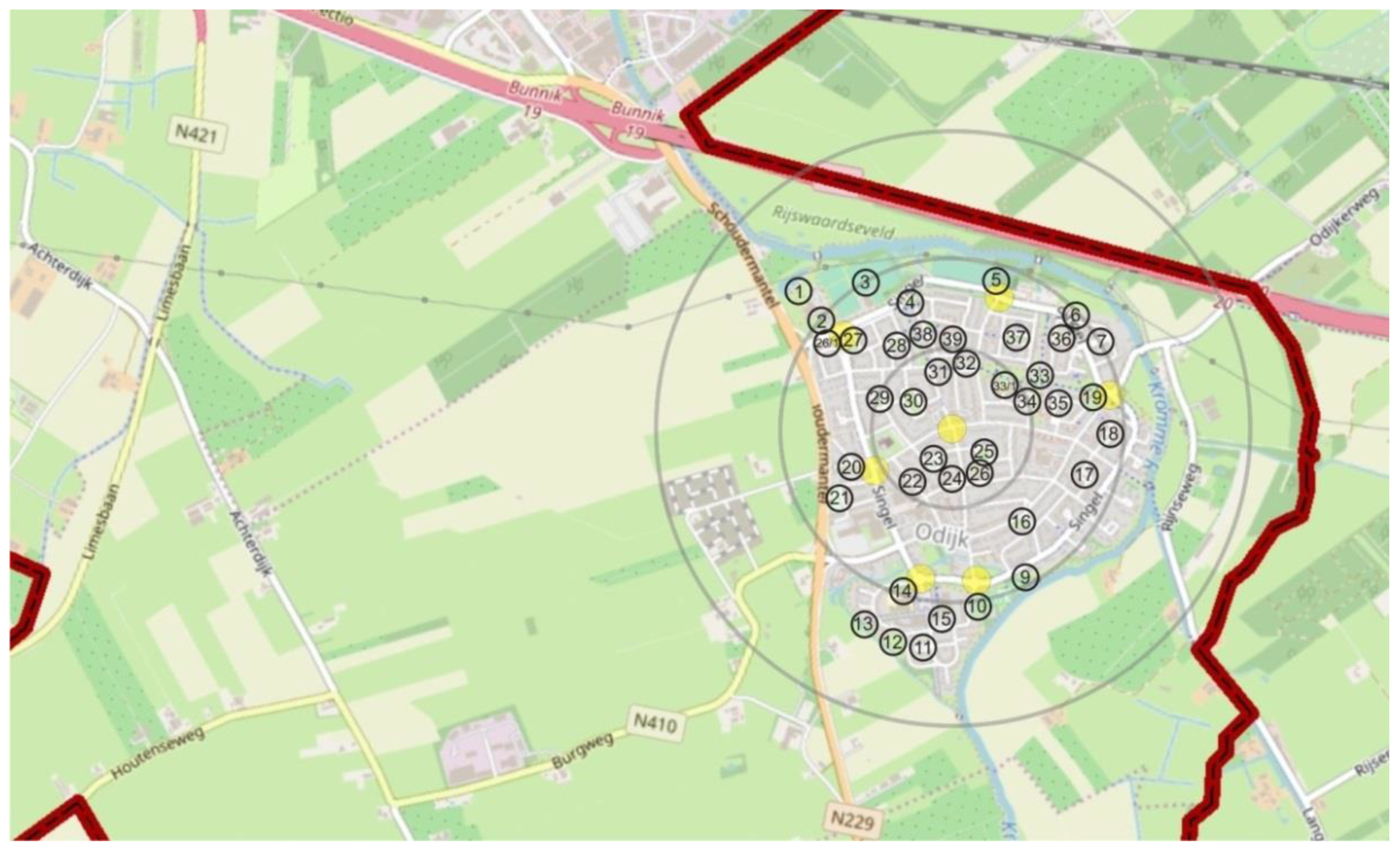
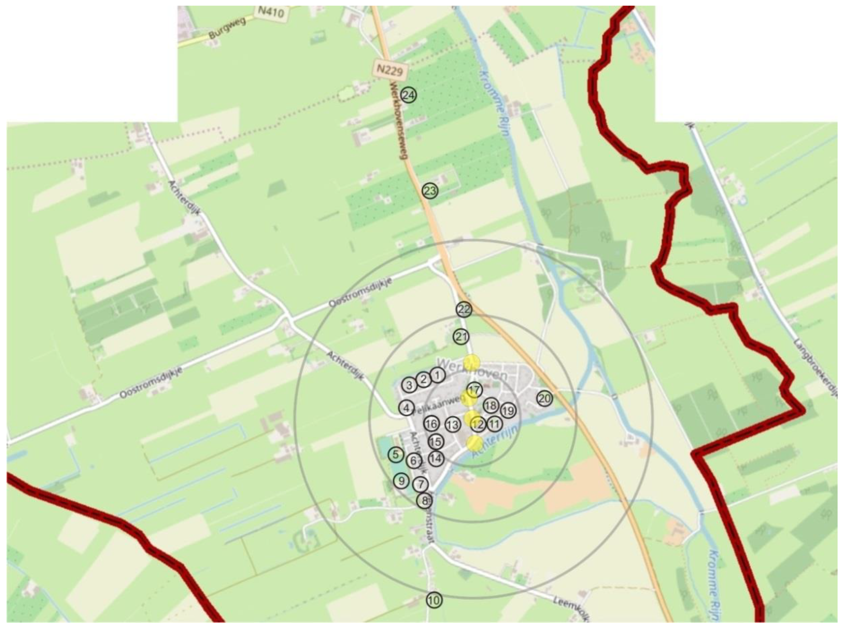
As a result, 122 POS objects were identified, of which 59 were located in Bunnik, 39 in Odijk and 24 in Werkhoven. Their location was correlated with communication hubs and the layout of access zones for pedestrian traffic (Figure 2, Figure 3 and Figure 4).
In the village of Bunnik, POS objects were located mainly in the central and north-western part of the village, which coincides with residential areas (Figure 2).
Three objects were outside the peripheral zone. However, they were well connected with the nearby estates mainly by pathways and bike routes. Two of the objects were located in a belt leading to the university grounds, and one was located en route to another town of the commune, Odijk.
In the case of Odijk, all POS objects were located within three access zones (Figure 3). Due to the size of the village (much smaller than Bunnik) and its compact layout, most of the objects were located in the local zone.
In Werkhoven, which is a small town, most of the POS objects were also located in the central and local pedestrian access zones (Figure 4). Three of them were located outside the peripheral zone. However, they were conveniently connected – two POS objects were located by the main road leading from Bunnik to Werkhoven, and the third was located in an agricultural area with attractive vistas at the end of one of the local roads.

3.3. Identification of the POS Types

Based on an analysis of the diagrams of POS spheres (Appendix B) and the structural models based on charts, descriptions, sketches and photos of the objects (Appendix C), 18 POS types were identified. These were (in terms of the number of POS objects representing them in): estate courtyard, multi-recreational estate lawn, public gateway, playground, greenery site, estate landscape corner, diner's garden, bench with a view, waterside corner, shopping street, open sports grounds, public allotment gardens, town square, multi-purpose school ground, cemetery, landscape walkways, urban farm, and countryside promenade. They are summarized in Table 1.
The most common type of POS was the estate courtyard. Another group of highly represented types were: estate lawn (19 objects), and greenery site (14 objects). The types with the least number of objects (1) were: mini zoo-like urban farm and countryside promenade. There were also several types that contained 3 objects, one in each locality. These were: open sports grounds and public allotment gardens. Please note that the size of the objects did not translate directly and proportionally into the number of their occurrences. Then, the quantitative distribution of the distinguished POS objects was analyzed per division into localities.
The following types were classified as “numerous”: courtyard, multi-recreational estate lawn and gateway. In the a medium-abundant group, there were playground, greenery site and estate landscape corner. The other types of POS were classified as “sparse”. It was interesting that two types were evenly distributed in all three localities, despite the different number of residents: open sports grounds and public allotments.
The data collected during the research was recorded in working tables (an exemplary table was presented in Appendix A), diagrams of POS types (Appendix B), and photos of exemplary POS objects that represent a given type, as well as structural models that describe it (Appendix C). The collected data were used to supplement the characteristics of the identified types of POS. Together, they comprised the first element of the set of best practices for POS suburbs.

3.4. Analysis of Top-Down Design and Planning Development

The following forms of top-down POS development were identified in the Bunnik municipality:
Estates with a recreational areas dedicated to the neighborhood community
Communal (extra-neighborhood) playgrounds
Greeneries by pedestrian routes
Social places in central zone
Multi-purpose recreational areas at schools, available to residents
Open sports grounds in every countryside town
Community allotment gardens in every countryside town
Communal facilities generating informal meetings
Entrance zones to public facilities with a social space value
Viewpoints accompanying pedestrian routes
Network of green walks for recreation in rural and natural landscapes.

3.5. Discussing of the Research Results

The Bunnik municipality has proven to abound in examples of case studies in two areas. First, as a suburban commune, where many different forms of gathering and recreational places have been established. On its territory, 122 POS objects were identified and grouped into 18 spatial-functional units (POS types). Secondly, Bunnik has many case studies of mature Dutch land use management. Featured in its area are 11 of top-down design and planning development.
Upon analyzing the research results, attention was drawn to the fact that effects of some top-down design and planning coincided in several cases with bottom-up development, such as:
gateways to public utility facilities that are at the same time community spaces
benches with the view as viewpoints “en route
a network of green walkways in peripheral areas intended for recreation in agricultural and natural landscapes
Gathering, rest, and recreation places, which emerged in the course of the research, were explored, characterized and categorized using the POS sphere method (Kępkowicz, 2019). This was made possible by the use of an interdisciplinary set of research methods stemming from environmental psychology, sociology and branding. Research techniques such as non-participant observation, analyses of physical traces, spatial measurement, and analysis of hedonic quality of space were drawn from them. Therefore, the validity of using the POS sphere method was confirmed.
Identified units of gathering and recreation places enhanced livability in Bunnik commune in a number of ways. They formed places for meetings and rest in housing estates, both multi-family and single-family ones. They were located by pedestrian routes and bike paths as places en route, acting as viewpoints and facilitating recreation and meetings in agricultural and natural areas located in the peripheral zone of towns belonging to the Bunnik commune. These places also improved the comfort of using public facilities and supported forming of interpersonal relationships, allowing for creating a community.
Taking into account the distinguished POS types and how they facilitate the livability of suburban commune, the following connections were noticed:
places that facilitate meetings (get-togethers):
of families and neighbors: estate courtyard, multi-recreational estate lawn, playground, diner's garden, open sports grounds, public allotment gardens, urban farm
of community/club members: open sports grounds, public allotment gardens
of those eager for contemplation: landscape corner, bench with a view, cemetery, landscape walkways
of casual bystanders: public gateway, playground, greenery site, shopping street, town square, multi-purpose school ground, cemetery, countryside promenade
of “gather and stare” partakers: public gateway, diner's garden, bench with a view, town square
places that serve:
active recreation: multi-recreational estate lawn, playground, open sports grounds, multi-purpose school ground, landscape walkways, countryside promenade, and (to some extent) public allotment gardens
leisure: estate courtyard, multi-recreational estate lawn, public gateway, greenery site, estate landscape corner, diner's garden, bench with a view, waterside corner, town square and landscape walkways.
Please note that most POS facilities (54 out of 122) were created in the immediate residential area. This indicates the important function of suburbs as bedroom communities for the parent cities, to which they are adjacent.

4. Conclusions

As a result of the study, a set of POS types of the suburban Bunnik municipality was developed in terms of top-down development of gathering and recreation places. The fact that objects belonging to some POS types were created both top-down and bottom-up was also taken into account.
Presented below is a characteristic of POS types supplemented by the set of diagrams of POS spheres attached in (Appendix B), photos of exemplary POS objects that represent a given type, as well as structural models that describe it (Appendix C).

5. POS Types Created Solely as a Result of Top-Down Planning and Design

5.1. Estates with a Recreational Areas Dedicated to the Neighborhood Community

5.1.1. Estate Courtyard

This type of POS is a distinct leader of the study among all 18 types. The estate courtyard is a small, occasionally medium square offering access to the properties comprising housing estates (mostly single-family estates). It is a place frequented by each of the residents and their guests and its dominant function is communication (Appendix C., Figure C.1).
As part of a housing estate, the courtyards are of local importance, with a high degree of urbanization. They are accessible to (slow) road, bicycle and pedestrian traffic, which made their safety level average.
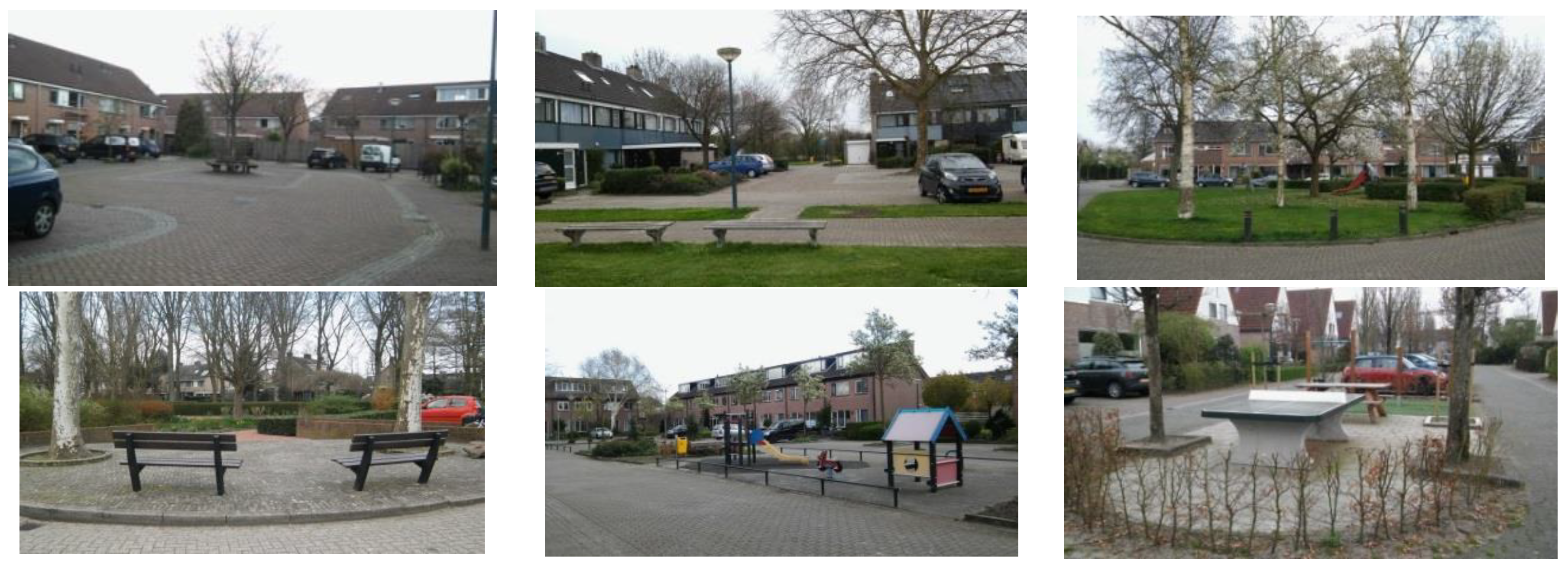
The courtyards are located in all access zones, as well as in the estates to which they belonged. Objects belonging to this type of POS serve also purposes other than access to the property and parking vehicles. Some of them are cobbled courtyards, but others are enriched with greens. Some are equipped only with benches, others also include playgrounds, barbecue areas, or ping-pong tables, and even sculptures. Some courtyards are an attractive mini-square due to grass patches or collections of ornamental plants, but the predominant plant form is the lawn. Waste baskets and lighting are a common element in all of them (App. C., Figure C.2).
The sensual analysis shows that estate courtyards are not entirely friendly and encouraging places for rest and meetings. Although their form and equipment often suggests a recreational function, there are too many cars, paved surfaces and concrete, and not enough intimacy to facilitate freedom of behavior. Another problem could be the fact that the courtyard area is visible from the windows of each property, which could act as a restraint in the case of some meeting forms. In addition, it was observed that hardened surfaces and building facades enhanced the noise levels, e.g. of playing children. It was also possible to notice that the courtyards are not always a "well groomed" place (as indicated by the presence of small rubbish and leaves that had not been cleared away). Therefore, it is questionable whether the estate courtyard is a type predestined for a recreational function, despite its equipment such as seats and grills.
In some cases the estate master plan assumes the presence of large individual gardens and the lack of an extensive multi-recreational estate lawn. This meant that the only common place for games, plays and recreation is the estate courtyard. Thus, combining the communication function with the idea of a mini-greenery or a leisure corner for chatting and resting on a bench in the shade of trees seems justified in the case of this type of layout. Objects that belong to the type estate lawn are owned by the estate authorities.

5.1.2. Multi-Recreational Estate Lawn

Objects of this type are located within estates and are vast grassy lawns resembling a park interior, and sometimes even constituted a small park (App. C., Figure C.3). The lawn is often directly adjacent to gates of home gardens. Sometimes the lawn is separated from the property by a footpath (App. C., Figure C.4). As in the case of the estate courtyard, the estate lawn is an integral part of the estate. Although not fenced, these places still gave the impression that they are dedicated primarily to the residents of the estate.
Multi-recreational estate lawns are carefully planned and designed. Often there is playground equipment in one place, seats in another, workout equipment in another, and a place with a gazebo or parking lots for bicycles in another. However, what dominated the space is a free grassy area with trees, sometimes surrounded by hedges.
These are extremely welcoming places, encouraging rest, sheltered from the wind and street noise, with a favorable arrangement of sunny and shaded places. Their connection with the recreational, social and natural spheres gave them a multifunctional character.
The lawns are intended for near-home recreation, for children to play games and families engage in a match of badminton or ball. It is also a place for picnics, sunbathing and more or less casual estate meetings.
Objects that belong to the type estate lawn, as well as the estate courtyard, are owned by the estate authorities.

5.1.3. Estate Landscape Corner

This type is represented by objects located also within estates. Contrary to courtyards or multi-purpose lawns, estate landscape corners can be found in the outer zone of the estates adjacent to the open areas (App. C., Figure C.5).
The estate landscape corner usually has the form of a small grassy lawn, often with trees, opening to a vista of surrounding meadows, fields, forests and water reservoirs. It is located at a certain distance from the roadways, but close to the pedestrian and bicycle routes (App. C., Figure C.6). For this reason, the level of security of the estate landscape corner type is high. Therefore, it could be used not only by the residents of the estates, but also by other passers-by.
Due to its cozy area, peripheral location and charming view, it is seemed perfect for passive leisure and contemplation, as well as casual meetings or picnics, which is facilitated by the provided seats.
Objects belonging to this type are located in the local and peripheral access zone, as are the estates to which they belonged and were managed by the estate communities.

5.2. Communal (Extra-Neighborhood) Playgrounds

The Playground

Places belonging to this type are located in the village, outside the estates and constitute a part of public urban space (App. C., Figure C.7). However, they are not connected with private properties. This meant that they could be used by the residents of many surrounding estates. The more so that they were located “en route”, in the streets (App. C., Figure C.8).
The playground is focused on a specific type of active recreation If it includes mobility games for children, then the area offers various playground equipment (e.g. slides, swings, ladders, playhouses). The playground is also a space for amateur sports games for the residents. At that time, these POS are furnished with soccer goals, gymnastic ladders, ping-pong tables, boule fields and workout equipment. They often offer seats, which also allowed for meetings during recreational activities: talking, cheering, resting after workout. The type of users depended on the type of sports, games, or activities facilitated by the type of equipment. This type of POS often consisted of two parts: a lawn (often grassy) for free activity and an area with playground or sports equipment. Often, to make the space more safe and friendly, these places are separated from the street by a hedge.
This type of POS was not common; it was owned by the local government.

5.3. Greeneries by Pedestrian Routes

Greenery Site

Objects belonging to the greenery site type are located mainly in built-up and highly urbanized areas, often in the proximity of estates (App. C., Figure C.9). They usually has the form of a triangle, seemingly shaped by the course of the nearby routes (App. C., Figure C.10).
Greenery sites play an environmental function. They are mostly lawns, sometimes covered with bushes, often separated from the road by a hedge. Sometimes they have sparse equipment (a lawn, one bench and a waste basket), and sometimes they are carefully arranged: decorated with sculptures, with designated paths and ornamental plants. Regardless of design, they are always well lit and well cared for.
Their social function is evidenced by the occasional benches located there, sometimes small play equipment for children (which seemed as if it is placed there by the parents). Therefore, these were places predestined for informal meetings or rest “on the go”. They make the city streets seem more green, friendly and encouraging walks. The greeneries’ degree of urbanization is average, with an average sense of security due to the nearby traffic.
The greeneries are easily accessible, located in all access zones, yet their character was local. They were managed by municipal authorities or housing associations.

5.4. Social Places in Central Zone

5.4.1. Shopping Street

Shopping street is one of the types drawn from a typical urban environment. Objects belonging to this type are located in the hub of the locality, or in its vicinity (App. C., Figure C.11). They are heavily urbanized, surrounded by buildings, well-lit, well-maintained, equipped with waste baskets, very good access and always a nearby parking lot (App. C., Figure C.12).
The shopping street has the shape of an elongated urban enclosure, approximately 100 m long. However, in the case of the studied towns, objects of this type are quite intimate in nature. This place is primarily used to make the commercial offer of the town center more attractive by enhancing its aesthetics (planters, sometimes trees or hedges, attractive street furniture), improving comfort of shoppers or service users (quiet places to rest in places are the sidewalks broadened, to stop for casual conversations or meetings), or improving accessibility for pedestrians by reducing vehicle traffic and congesting the commercial and service functions.
Since commercial streets are located in built-up and heavily urbanized areas, one of the most important elements of their “equipment” is the surface: appealing, well-paved and facilitating traffic organization, including pedestrian. This element is important because the shopping street often include pedestrian, bicycle and road routes. Due to its communication function (although with reduced traffic), the level of safety is quite low here (mainly due to heavy bicycle traffic and nearby road traffic).
The shopping street type is not common, two objects of this type are located in two towns (Bunnik and Odijk). In the smallest town, Werkhoven, no object of this type was identified.
Buildings belonging to the shopping street type are the responsibility of the municipality or/and private individuals.

5.4.2. Town Square

Next to the shopping street, the town square is another type drawn from urban area (App. C., Figure C.13). It is located in the central zone of the town. Based on evaluative features belonging to all six POS spheres (structural, economic, recreational, natural, social and cultural), objects belonging to this type prove to be largely multifunctional. The town square serves a number of functions:
social (as a place for various types of meetings)
economic (some buildings and cabins serve as commercial and catering facilities)
natural (e.g., lawn with ornamental plants, the square overgrown with tall trees)
recreational (frequent of seats for passive relaxation, and paths for walks)
cultural (spatial arrangement with elements of street furniture, a vista from the square and objects of cultural and historical significance)
structural (objects forming a legible urban enclosure and mark points).
Town squares are pedestrianized, but with convenient communication on the outskirts (App. C., Figure C.14). Despite their location in a highly urbanized zone, they have a significant share of biologically active area. The town square areas were excluded from road traffic, but they were surrounded by quite heavy vehicle, pedestrian and bicycle traffic. Their level of sense of security is medium.
Please note that both of the distinguished objects belonging to the town square type in Bunnik commune, were located in a single town, and the smallest one – Werkhoven, but not in the commune's “capital”, Bunnik, nor in Odijk, where the authorities resided. Both objects belonging to the town square type were managed by the commune.

5.5. Open Sports Grounds in Every Countryside Town

Open Sports Grounds

The open sports grounds occupy a vast area mainly in the peripheral zone of the village (App. C., Figure C.15). Objects of this type are scarce in the commune – one object per town. Open sports grounds are heavily invested and well connected, with nearby parking lots (App. C., Figure C.16). Objects belonging to this type are of local importance, created to serve the town’s community, with full-size football, handball, volleyball, field hockey, basketball fields, tennis courts, etc. There are also treadmills and athletics equipment on the premises. Many objects have small cheering stands, seats or rain shelters.
Lawns predominate in the open sports grounds, accompanied by single trees and shrubs. These objects are adjacent to an open agricultural, water and forest landscape. They also have a low to medium degree of urbanization.
Objects of this type are used for joint and individual sports practice, cheering and informal meetings (e.g. parents accompanying children to sports classes). Separated from the surroundings and isolated from traffic limited to the front zone, they ensure a high degree of safety. Open sports grounds are managed by local authorities and private companies.

5.6. Community Allotment Gardens in Every Countryside Town

Public Allotment Gardens

Objects belonging to this type are extensive, fenced areas intended for the urban horticulture and divided into individual plots. It is an area are amateur gardeners cultivate crops and ornamental plants are grown on an amateur basis (App. C., Figure C. D.17).
Public allotment gardens located in the Bunnik commune are well-kept objects, with appealing gateways, necessary infrastructure, seats and small recreational cabins. Each object belonging to this type is located on the outskirts of residential areas in the vicinity of open areas, with good access roads and a parking space (App. C., Figure C.18). These areas, despite the apparent chaos, are carefully composed. The presence of many plants, seats, aesthetic fences and decorations make the gardens a friendly space for rest and integration. Public allotment gardens are used presumably for individual relaxation and spending time with relatives and friends. They are also a place of informal meetings, as well as meetings of the allotment tenant community, as evidenced by the seats located in the common space.
Their degree of urbanization is medium, with a high sense of security. They are of local importance because they serve the residents of one town. On the other hand, they also had local significance, but they were not assigned to a single estate. Public allotment gardens were built and managed by local authorities.

5.7. Multi-Purpose Recreational Areas at Schools, Available to Residents

Multi-Purpose School Grounds

Objects belonging to this type have an important social and recreational function. The multi-purpose school grounds is a presumed meeting place for children, their guardians and teachers, as well as users of the educational and sports offer provided by the school. Occasional events are also held on their extensive lawns.
The multi-purpose school grounds is a complex that includes public sports areas (albeit with a smaller selection than the outdoor sports facilities), playgrounds, outdoor classrooms, educational gardens and seating areas located in near the entrance to the school. The complex encourages integration also outside school: games and activities (children), sports (children, parents, residents) and casual meetings and conversations (e.g. between parents) (App. C., Figure C.19). Objects belonging to this type are not only functionally designed, but also appealing and welcoming rest. They are well lit, equipped with street furniture (including retaining walls, stairs, gazebos, platforms and terraces). The plantings are organized greenery site: mainly lawns with ornamental shrubs and trees (especially on the edge), which bring to mind invested city park (App. C., Figure C.20). The multi-purpose school grounds are well connected and offers parking space. It has an average degree of urbanization and a high sense of security.
This type of POS can be located in the central zone of the suburban village or in the local zone, on the outskirts of the town. These facilities are owned by the municipality.

5.8. Communal Facilities Generating Informal Meetings

Cemetery

It’s a type of public space with an important communal function. The cemetery is a burial place and at the same time a place for meetings, reflection and contemplation. The objects belonging to the cemetery type are an arranged site, with an impressive gateway (App. C., Figure C.21). As a place of last farewell and burial, cemeteries have the rank of a sacred place, with an appropriate architectural setting. The vegetation includes flowers (cut and artificial) as well as columnar varieties of coniferous plants. The cemetery was furnished with benches, waste baskets and lighting.
Cemeteries are places of meetings with family and honoring the departed loved ones, as well as of informal meetings with other visitors. As a space fenced off and shielded from direct view from the outside by a wall or hedge, they brought to mind a kind of secret garden (App. C., Figure C.22).
Objects belonging to this type are scarce (some of them were too difficult to find to be classified as an all-accessible POS), and their location depend on the size of the town. Cemeteries are located both among the buildings and on the outskirts of the town, near roadways. Besides, there is always a car park in their vicinity. Their degree of urbanization is medium, and their sense of security is high.
Cemeteries were of supra-local importance. They were managed by the communal authorities.

6. POS Types Created as a Result of Both Top-Down Planning and Design and Bottom-Up Development:

6.1. Entrance Zones to Public Facilities with a Social Space Value

Public Gateway

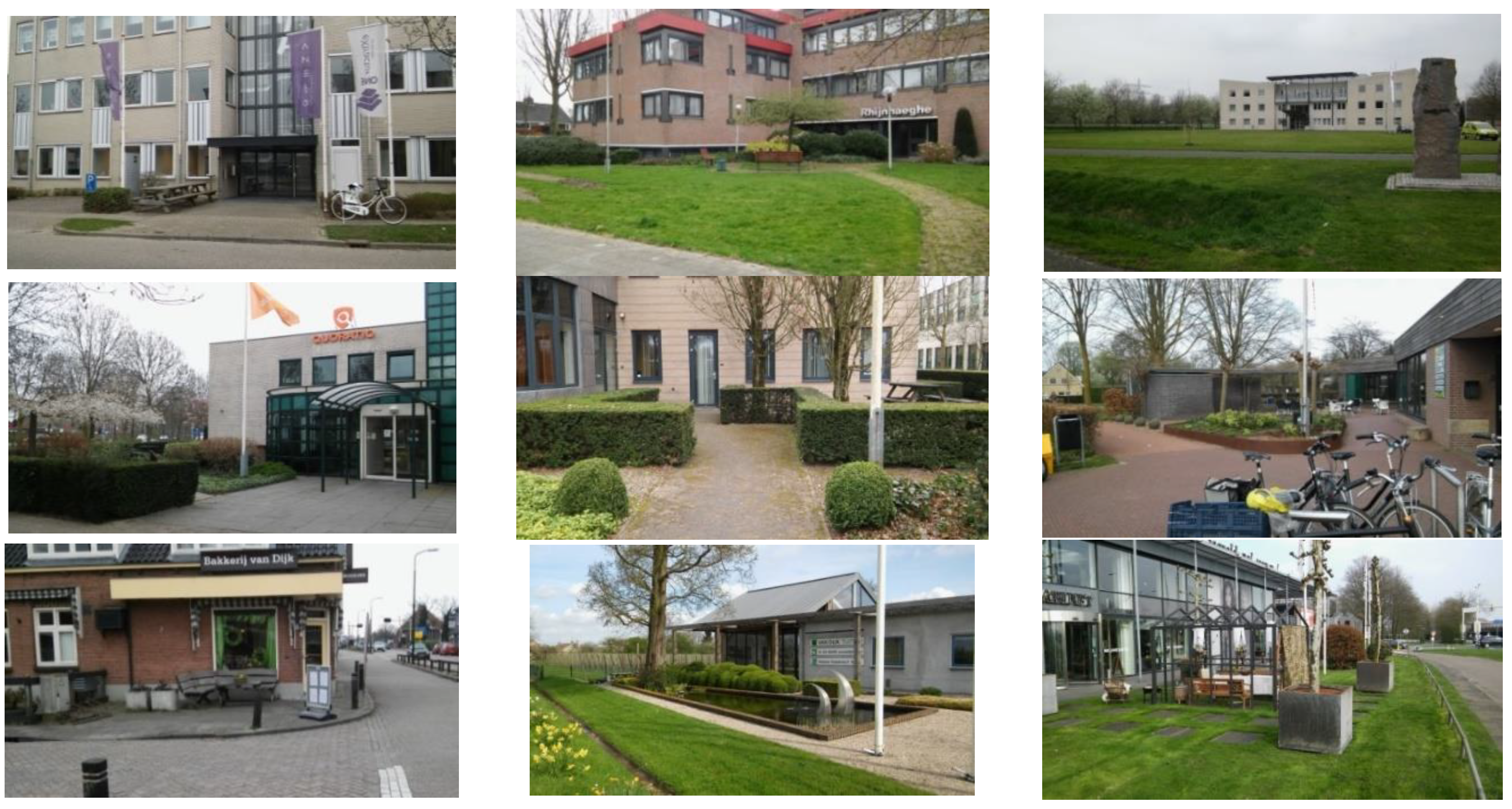
This type of POS is created by places that are a transition zone between the street and some kind of a public facility: a seat of the municipal office (the aforementioned case), shops, health centers, administration offices, or a private business (App. C., Figure C.23). The gateways are usually small squares, sometimes even mini-squares with seats, gazebos and ornamental plants.
The public gateway’s primary function is to represent and point to the prominence of the facility. Its attractiveness and friendliness is also perceived by the author as a manifestation of the preferred style and standard of work (especially in the case of private companies).
The gateway area often offers places to recreation (e.g. seats or even gazebos). The appeal of these places is enhanced by attractive plant compositions, decorative plant pots and appealing street furniture. All this builds not only the image of the company or administration office, but also serves as a place of relaxation for customers or employees. The convenient location of these objects and easy, straight-on access could also encourage passers-by to stop in these locations (App. C., Figure C.24). The public gateway is suitable for passive recreation: sitting and waiting, consumption and conversations, it also encourages casual meetings, stopping by for a brief exchange, or for eating together (in the case of a company). It could also be suitable for company events (e.g. in the case of the gateway to the head office of the commune).
The gateways also serve as an exhibition area, attracting the customers and encouraging purchase. Such is the case with an orchard farm, a furniture store or a gardening store, where the gateway showcases seedlings, garden furniture or fruit.
These places are sometimes arranged spontaneously (mainly private businesses), and sometimes carefully designed, which is indicated by the consistency of the compositional arrangement with the building.
Depending on the type of barrier separating the entrance to the facility from the street, the public gateway have a different degree of security – from average to high.
Objects belonging to this type are located in all access zones because that was where the buildings they were associated with are located. The type of the object also depended on whether the building is managed by a state, local government or private entity, which determines its importance: local (e.g. shops) or supra-local (e.g. commune office).

6.2. Viewpoints Accompanying Pedestrian Routes

Bench with a View

The core of the places belonging to the bench with a view type is, as the name suggests, a bench (or other seat) with a scenic view (App. C., Figure C.25). This type differs from the greenery site type in that it is not always a green area. A bench with a view could be found also on the street (then it was a paved place) and by a countryside route (then the place is covered with grass). Due to their small area, objects belonging to this type could be treated as vantage points (App. C., Figure C.26).. These are well-maintained places (e.g. equipped with waste baskets) and often well-lit.
The main function of objects belonging to the bench with a view type is passive recreation during a walk. It is a place encouraging solitary contemplation or conversations with a walking companion, less often meetings with friends. Due to the small size of the benches themselves, these places are rather unsuitable for casual meetings. Benches with a view encourage every by-passer to rest. They could also serve as a place for an en route rest for people with mobility problems, e.g., senior citizens or children.
Objects belonging to the type of bench with a view have a varied degree of urbanization and a high to average sense of security (depending on the distance from the road). Places of this type are located in all access zones and are of local significance. They are managed either by private owners or municipal authorities.

6.3. Network of Green Walks for recreation in Rural and Natural Landscapes

6.3.1. Waterside Corner

Objects belonging to this type are located in an open landscape and have the form of wooden or stone platforms located directly over the water. Their main attribute is the vicinity of a canal, river or pond, and the presence of wildlife (App. C., Figure C.27).
The waterside corners are intimate enclosures located in the peripheral zone of the town. They are far from human settlements, as well as from roadways, although they are always close to pedestrian and bicycle routes (App. C., Figure C.28). The corners offer fishing, passive recreation and the scenic views of the surrounding meadows, fields and forests. Therefore, they seem more like meeting places with nature than with people.
The degree of urbanization of the area is low, and the sense of security in these objects is quite high, especially due to the lack of traffic. On the other hand, the potential for contact with wildlife and the lack of lighting presents some risk. However, this is not seem to be a disadvantage as the pleasure of contact with nature prevailed.
Waterside corners are not common objects. Due to their purpose (en route rest, fishing) they have supra-local significance. Objects belonging to this type are both in private hands and under communal management.

6.3.2. Landscape Walkways

The essence of this type of POS is the presence of agricultural, forest and waterside areas with an appealing landscape, and, on the other hand, the network of unpaved pedestrian-bicycle routes (App. C., Figure C.29). The observed activities that the residents engage in on landscape walkways include, first of all, walking, jogging, Nordic walking and cycling.
Objects belonging to the landscape walkways type are located on the outskirts of the two studied towns (in the peripheral and local zone, depending on the size) (App. C., Figure C.30). As observed, they are part of an supra-local natural system.
The walkways are not arranged as landscape parks, although the routes were occasionally accompanied by bridges, benches, lanterns or waste bins. Besides, the area provided the pleasure of communing with wild nature.
The landscape walkways has one of the lowest degrees of urbanization. The level of security in this area is perceived in two ways – as high, because there is no vehicular traffic here, and medium, due to a certain degree of risk (the walkways are neither lit, nor under surveillance).
The landscape walks has supra-local significance. The ground on which they were located belong to the commune or private owners.

6.3.3. Countryside Promenade

Due to its function and form, this type of POS resembled a city promenade, however located in an open landscape (App. C., Figure C.31).
The countryside promenade leads from the suburban town to a nearby attractive site (App. C., Figure C.32). It is a type of high recreation and leisure rank due to the attractiveness of its destination (e.g., the university campus), the objects it leads through (e.g., restaurants), as well as the beauty of the surrounding open landscape of agricultural areas and watersides with shimmering water streaks, trees and picturesque buildings in the distance. The countryside promenade had a paved and unpaved surface, lighting (in strategic places), occasionally benches and waste baskets.
The users of this place use it, as observed, primarily for walking, jogging and cycling. It enables not only efficient communication between the town and the campus, but also outdoor activity s in contact with nature and a beautiful vista.
The degree of urbanization of this type of POS was low, and its sense of security was high to medium (quite intensive bicycle traffic).
The countryside promenade was distinguished only in Bunnik. It had supra-local significance. Due to its extent, it ran through land with diverse ownership, both private and local government.

7. Other POS Types (Resulting from Bottom-Up Development):

7.1. Diner's Garden

The diner's garden type is somewhat similar to the public gateway type. The main difference is that its basic function is to generate income.
Objects belonging to this type, as well as gateways, have the form of a small square (usually paved) adjacent to the parent object – in this case a catering facility (e.g. a hotel, restaurant, a cafe, a bar or an ice cream shop). They are easily accessible, located near routes, always with a parking nearby (App. C., Figure C.33-34).
The diner's gardens are cozy and appealing, with many flower pots, vines and shrubs and occasional sculptures or water features. Some gardens offer a nice view of the surrounding urban, wild or rural landscape.
These places are available to everyone, and are used for meetings with family or friends, as well as individual relaxation. The diner's gardens are also a kind of vibrant social arena (Cattell et al., 2008) – a place to observe other people and at the same time to become an object of observation oneself.
The diner's gardens are located in all access zones, providing the opportunity for rest both in the central zone of the town and in the picturesque open areas. They also have a different degree of urbanization. Due to the barriers separating them from the nearby street their level of security is quite high. The diner's gardens have supra-local significance and are privately owned.

7.2. Urban Farm

This type was represented in Bunnik commune by a mini farm with a wooden stable and a paddock for goats (App. C., Figure C.35). It is a fenced vast site on the edge of residential areas, in contact with the open landscape, covered with grassland and occasional trees. There was no traffic noise here, despite a nearby local street (App. C., Figure C.36).
This site encourages passive rest: pausing and observing animals in a friendly, semi-rural environment, which is facilitated by the nearby walking and cycling route. As observed, the goat farm is a destination for family trips, but also casual conversations and exchange of impressions. It provides the pleasure of communing with grazing and frolicking goats, which attracts both children and adults.
This place has a supra-local character, with a low degree of urbanization and a high sense of security. The urban farm is owned by a private institution.

8. Summary

The 18 POS types identified in the Bunnik suburban commune became the first stage for identifying types of gathering and recreation places of suburbs in the context of top-down design and planning. Taking into consideration the above factors, the following POS types related to top-down forms of development were distinguished:
POS types created solely as a result of top-down planning and design are as follows:
Estates with a recreational areas dedicated to the neighborhood community: estate courtyard, multi-recreational estate lawn, estate landscape corner
Communal (extra-neighborhood) playgrounds: playground
Greeneries by pedestrian routes: greenery site
Social places in central zone: shopping street, town square
Multi-purpose recreational areas at schools, available to residents: multi-purpose school ground
Open sports grounds in every countryside town: open sports grounds
Community allotment gardens in every countryside town: public allotment gardens
Communal facilities generating informal meetings: cemetery
POS types created through both top-down planning and design, and grassroots/bottom-up efforts:
Entrance zones to public facilities with a social space value: public gateway
Viewpoints accompanying pedestrian routes: bench with a view
Network of green walks for recreation in rural and natural landscapes. landscape walkways, countryside promenade ,waterside corner
POS types created only as a result of bottom-up development: diner's garden and urban farm.
The results of the study are another step in the exploration of the suburbs as a research area. Both POS types with their characteristics and the developed set of forms of top-down design and planning with their assigned types will find use in the development of POS.
The types of POS obtained will also become an essential starting point for the development of the POS system of the Bunnik commune. They will contribute to research on the optimal development of suburban public space, the formulation of its standards, or the search for its representative types to. When thinking about continuing research related to the study field, it would be interesting to conduct a field survey in the Bunnik commune to learn about residents' opinions on the livability of the studied POS.
On the one hand, the set of top-down design and planning in gathering an recreational places can be an inspiration or starting point for further developments of others suburban public spaces (for despite their differences, suburban areas have many features in common). They can serve investors, urban planners and designers in the creation of new and redevelopment of existing POS.

Funding

This work (text translation, publication) was supported by the Ministerstwo Edukacji i Nauki, Poland [grant No DNK/SP/546699/2022].

Appendix A. The Table with an Exemplary Characteristics of a POS Type (in this Case an Estate Courtyard)

Table A1. Characteristics of the estate courtyard type of POS.
TYPE OF FEATURE FEATURE DESCRIPTION
1 Leading function communication
2 Urban arrangement urban enclosure of intimate scale (courtyard or small traffic island)
3 Equipment always: paved surface (sidewalk, roadway, parking lot, square), lighting, waste bins; often: playground equipment, seats, grill;sometimes: a patch of grass
4 Presumed purpose access to own property located in a housing estate
5 Accessibility (access zones: central, local, peripheral; type of traffic; access restrictions) located in all access zones;available for road, bicycle and pedestrian traffic;local traffic only
6 Area size medium
7 Presumed type of users residents of the estate and their acquaintances
8 Presumed form of meetings and integration always: informal meeting of the neighbors;often: socializing among neighbors (e. g., grilling, gardening, talking, sitting on benches, engaging in games; children playing)
9 Presumed type of leisure sitting on benches; playing; grilling; gardening
10 Type of vegetation Occasional: lawn, trees, ornamental plants
11 Landscape values Small-town landscape
12 Spatial relations with the environment in the heart of the estate, adjacent to the nearest street
13 Degree of urbanization of the area high
14 Safety level average due to traffic, but a very local one
15 Prevalence numerous
16 Local or regional significance local
17 Type of land ownership property of the estate authorities
18 Observed top-down form of development a place designed by the developer's designers

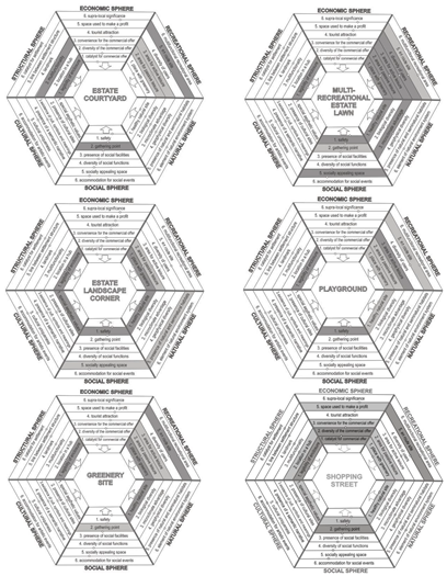
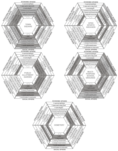
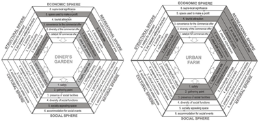
Appendix B. Diagrams of POS Types

POS types created solely as a result of top-down planning and design:
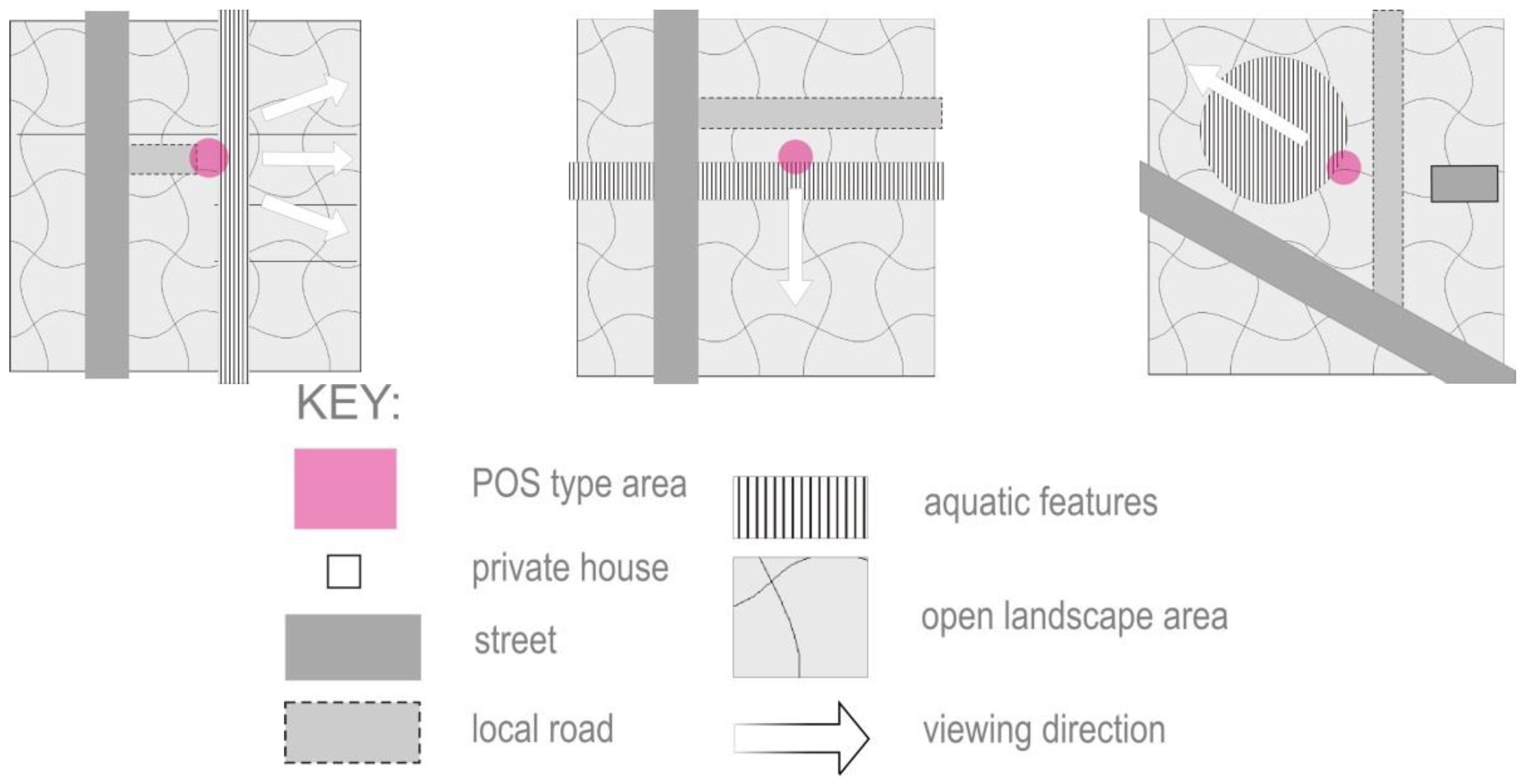
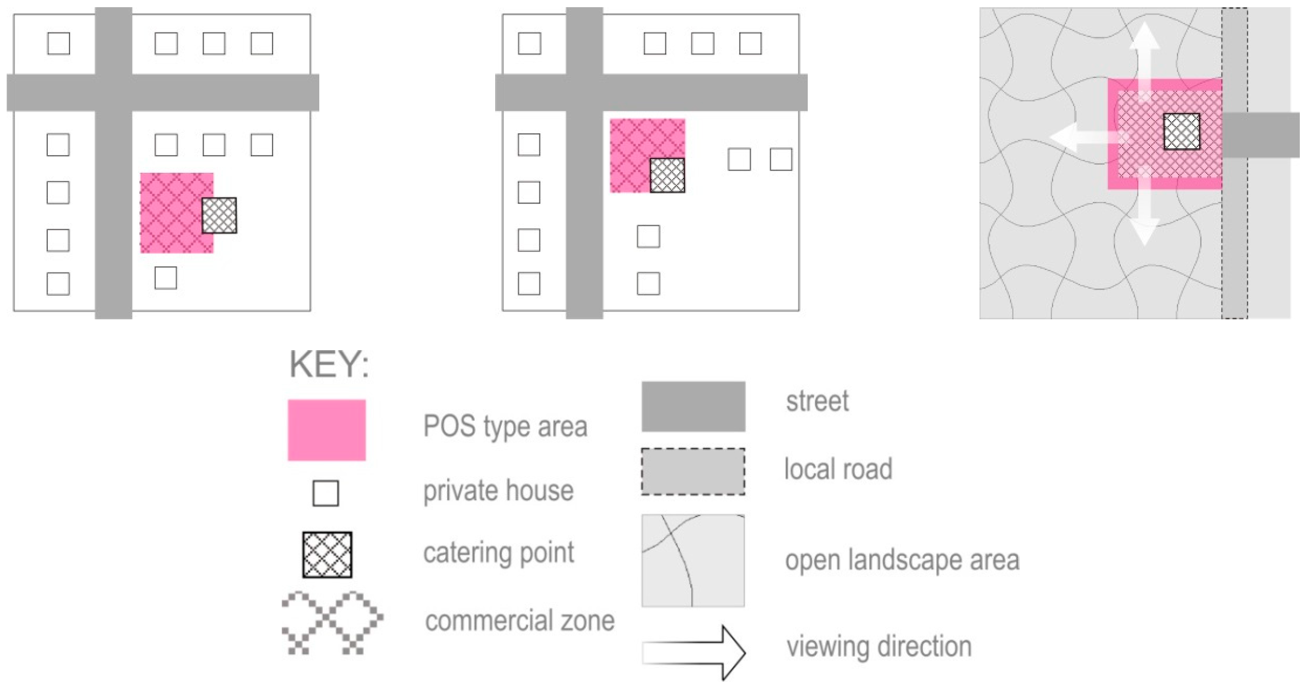
Preprints 114700 i001
Preprints 114700 i002
POS types created as a result of both top-down planning and design and bottom-up development:
Preprints 114700 i003
Other POS types (resulting from bottom-up development)
Preprints 114700 i004

Appendix C. Photos of Exemplary POS Objects that Represent a Given Type, as well as Structural Models that Describe It
POS types created solely as a result of top-down planning and design:
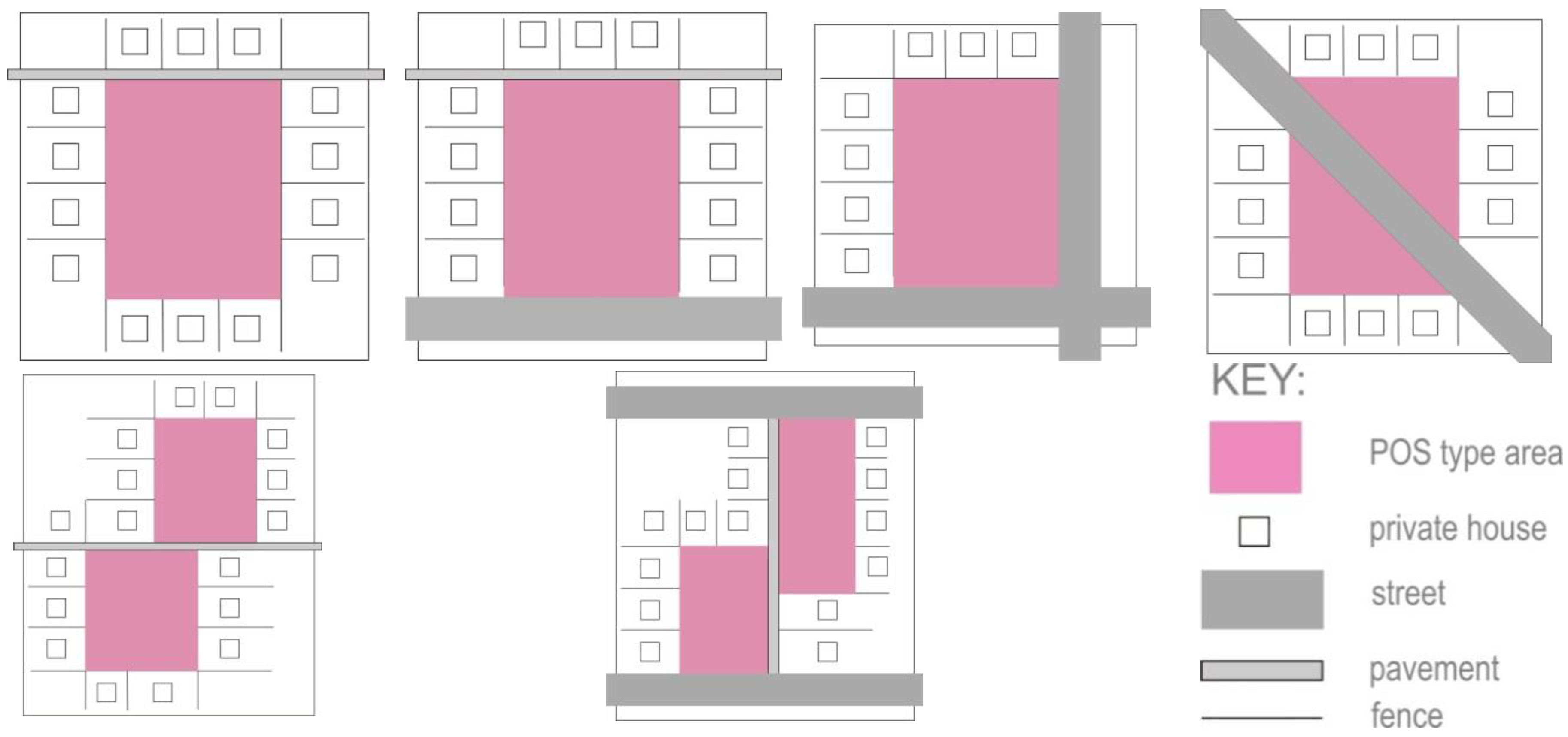
Figure A1. Examples of estate courtyard POS type.
Preprints 114700 g0a1
Figure A2. Structural models for the estate courtyard POS type.
Preprints 114700 g0a2
Figure A3. Examples of multi-recreational estate lawn POS type.
Preprints 114700 g0a3aPreprints 114700 g0a3b
Figure A4. Structural models of the multi-recreational estate lawn POS type.
Preprints 114700 g0a4
Figure A5. Examples of estate landscape corner POS type.
Preprints 114700 g0a5
Figure A6. Structural models of the estate landscape corner POS type.
Preprints 114700 g0a6
Figure A7. Examples of playground POS type.
Preprints 114700 g0a7aPreprints 114700 g0a7b
Figure A8. Structural models of the playground POS type.
Preprints 114700 g0a8
Figure A9. Examples of greenery site POS type.
Preprints 114700 g0a9
Figure A10. Structural models of the greenery site POS type.
Preprints 114700 g0a10
Figure A11. Examples of a shopping street POS type.
Preprints 114700 g0a11
Figure A12. Structural models of the shopping street POS type.
Preprints 114700 g0a12
Figure A13. Examples of town square POS type.
Preprints 114700 g0a13
Figure A14. Structural models of the town square POS type.
Preprints 114700 g0a14
Figure A15. Examples of open sports grounds POS type.
Preprints 114700 g0a15
Figure A16. Structural models of the open sports grounds POS type.
Preprints 114700 g0a16
Figure A17. Examples of public allotment gardens POS type.
Preprints 114700 g0a17
Figure A18. Structural models of the public allotment garden POS type.
Preprints 114700 g0a18
Figure A19. Examples of gathering and recreation place belonging to the school in Bunnik (multi-purpose school grounds POS type).
Preprints 114700 g0a19
Figure A20. Structural models of the multi-purpose school grounds POS type.
Preprints 114700 g0a20
Figure A21. Examples of cemetery POS type.
Preprints 114700 g0a21
Figure A22. Structural models of the cemetery POS type.
Preprints 114700 g0a22
POS types created as a result of both top-down planning and design and bottom-up development:
Figure A23. Examples of public gateway POS type.
Preprints 114700 g0a23
Figure A24. Structural models of the public gateway POS type.
Preprints 114700 g0a24
Figure A25. Examples of bench with a view POS type.
Preprints 114700 g0a25
Figure A26. Structural models of the bench with a view POS type.
Preprints 114700 g0a26
Figure A27. Examples of waterside corner POS type.
Preprints 114700 g0a27
Figure A28. Structural models of the waterside corner POS type.
Preprints 114700 g0a28
Figure A29. Examples of landscape walkways POS type.
Preprints 114700 g0a29
Figure A30. Structural model of the landscape walkways POS type.
Preprints 114700 g0a30
Figure A31. An example of a countryside promenade POS type.
Preprints 114700 g0a31
Figure A32. The structural model of the countryside promenade POS type.
Preprints 114700 g0a32
Other POS types (resulting from bottom-up development):
Figure A33. Examples of diner's garden POS type.
Preprints 114700 g0a33
Figure A34. Structural models of the diner's garden POS type.
Preprints 114700 g0a34
Figure A35. Example of an urban farm POS type.
Preprints 114700 g0a35
Figure A36. Structural model of the urban farm POS type.
Preprints 114700 g0a36

References

  1. Kępkowicz, Agnieszka (2023), “Method for creating public open space typology in line with the idea of place-making”, Mendeley Data, V1. [CrossRef]
  2. Airgood-Obrycki, W., Hanlon, B., & Rieger, S. (2021). Delineate the U.S. suburb: An examination of how different definitions of the suburbs matter. Journal of Urban Affairs, 43(9). [CrossRef]
  3. Al-hagla, K., & Al-hagla, K. (2008). Towards a sustainable neighborhood: the role of open spaces. International Journal of Architectural Research, 2(2).
  4. Alexander, C., Ishikawa, S., & Silverstein, M. (1977). A Pattern Language: Towns, Buildings, Construction. University Press.
  5. Basu, R., & Fiedler, R. S. (2017). Integrative multiplicity through suburban realities: exploring diversity through public spaces in Scarborough. Urban Geography, 38(1). [CrossRef]
  6. Bell, P. A., Greene, T. C., Fisher, J. D., & Baum, A. S. (2001). Environmental Psychology (5th ed.). Harcourt College Publishers. [CrossRef]
  7. Bravo, L., & Crawford, M. (2014). Publics and their spaces. Renewing urbanity in city and suburb. New Urban Configurations.
  8. Buckenberger, C. (2015). Good Cities, Better Lives—How Europe Discovered the Lost Art of Urbanism. Housing Studies, 30(4). [CrossRef]
  9. Carmona, M. (2010). Contemporary public space, part two: Classification. Journal of Urban Design, 15(2). [CrossRef]
  10. Carmona, M. (2022). The existential crisis of traditional shopping streets: the sun model and the place attraction paradigm. Journal of Urban Design, 27(1). [CrossRef]
  11. Cattell, V., Dines, N., Gesler, W., & Curtis, S. (2008). Mingling, observing, and lingering: Everyday public spaces and their implications for well-being and social relations. Health and Place, 14(3). [CrossRef]
  12. Chase, J., Crawford, M., & John, K. (1999). Everyday Urbanism. New York: Monacal Press.
  13. Classification framework for public open space. healthier, happier and safer communities. (2012).
  14. Davidson, R. A. (2013). “Friendly authoritarianism” and the bedtaun: Public space in a Japanese suburb. Journal of Cultural Geography, 30(2). [CrossRef]
  15. Dines, N., Cattell, V., Gesler, W., & Curtis, S. (2006). Public spaces, social relations and well-being in East London. The Policy Press.
  16. Dinic, M., & Mitkovic, P. (2016). SUBURBAN DESIGN: FROM ``BEDROOM COMMUNITIES{’’} TO SUSTAINABLE NEIGHBORHOODS. GEODETSKI VESTNIK, 60(1). [CrossRef]
  17. Eriawan, T., & Setiawati, L. (2017, June 15). Improving the quality of urban public space through the identification of space utilization index at Imam Bonjol Park, Padang city. AIP Conference Proceedings 1855, 040018 (2017).
  18. Fieldhouse, K. (2002). Parks and green spaces: Unlocking a fresh vision. Proceedings of the Institution of Civil Engineers: Municipal Engineer, 151(3). [CrossRef]
  19. Flusty, S. (2021). Building paranoia. In Public Space Reader. [CrossRef]
  20. Francis, M., & Griffith, L. (2011). The meaning and design of farmers’ markets as public space: An issue- based case study. In Landscape Journal (Vol. 30, Issue 2). [CrossRef]
  21. Gachowski, M. (2008). Przestrzeń publiczna w mieście jako towar pożądany, przestrzeń publiczna w mieście jako towar niebezpieczny. Biblioteka “Urbanisty”.
  22. Galle, M., & Modderman, E. (1997). Vinex: national spatial planning policy in the netherlands during the nineties. Netherlands Journal of Housing and the Built Environment, 12(1), 9–35. [CrossRef]
  23. Gehl, J. (2011). Life between Buildings: Using Public Space. Washington DC: Island Press.
  24. Gehl, J., & Gemzøe, L. (2001). New city spaces (2. rev. ed). The Danish Architectural Press.
  25. Goffman, E. (1966). Behavior in Public Places: Notes on the Social Organization of Gatherings. Free Press.
  26. Google Maps. (n.d.). Retrieved December 3, 2022. Available online: https://www.google.pl/maps/.
  27. Gulick, J. (1997). The ``Disappearance of Public Space’’: An Ecological Marxist and {L}efebvrian Approach. In Philosophy and Geography II: The Production of Public Space.
  28. Hall, P. (2021). Building Sustainable Suburbs in the Netherlands. In Routledge (Ed.), Good Cities, Better Lives. Available online: https://www.taylorfrancis.com/chapters/mono/10.4324/9781315888446-13/building-sustainable-suburbs-netherlands-peter-hall.
  29. Harris, R. (2015). Using Toronto to explore three suburban stereotypes, and vice versa. Environment and Planning A, 47(1). [CrossRef]
  30. Harris, R., & Lehrer, U. (2018). The Suburban land question: A global survey. In The Suburban Land Question: A Global Survey.
  31. Horrigan, D. (2019, May 16). Why Public Spaces Are Critical Social Infrastructure. GOVERNING - The Future of States and Localities. Available online: https://www.governing.com/gov-institute/voices/col-parks-community-centers-public-spaces-critical-social-infrastructure.html.
  32. Huang, Y., Hui, E. C. M., Zhou, J., Lang, W., Chen, T., & Li, X. (2020). Rural Revitalization in China: Land-Use Optimization through the Practice of Place-making. Land Use Policy, 97. [CrossRef]
  33. Jałowiecki, B. (2010). Społeczne wytwarzanie przestrzeni. Scholar.
  34. Karsten, L., Lupi, T., & Stigter-Speksnijder de, M. (2013). The middle classes and the remaking of the suburban family community: Evidence from the Netherlands. Journal of Housing and the Built Environment, 28(2). [CrossRef]
  35. Kępkowicz, A. (2019). Identyfikacja typów przestrzeni publicznej. In Identyfikacja typów przestrzeni publicznej. University of Warsaw PRESS. [CrossRef]
  36. Kępkowicz, A., Lipińska, H., & Mantey, D. (2019). Suburbs vs Third Places? IOP Conference Series: Materials Science and Engineering, 471(9). [CrossRef]
  37. Kępkowicz, A., & Mantey, D. (2016). Suburbs as None-Places? The Need for Gathering Places: a Case Study of the Warsaw Suburbs. Landscape Architecture, 1, 67–83.
  38. Kępkowicz, A., Mantey, D., Lipińska, H., & Wańkowicz, W. (2014). The “club” landscape as an kind of substitutive public spaces of suburbia (Krajobraz „klubowy” jako wyraz substytutywnych przestrzeni publicznych suburbiów). Architektura Krajobrazu, 3, 67–83.
  39. Kohn, M. (2021). Brave new neighborhoods: The privatization of public space. In Public Space Reader. [CrossRef]
  40. Lörzing, H. (2006). Reinventing Suburbia in the Netherlands. Built Environment, 32(3). [CrossRef]
  41. Ma, X., Tian, Y., Du, M., Hong, B., & Lin, B. (2021). How to design comfortable open spaces for the elderly? Implications of their thermal perceptions in an urban park. Science of the Total Environment, 768. [CrossRef]
  42. Madden, K., Wiley-Schwartz, A., & Antoshak, A. (2010). How to Turn a Place Around: A Handbook for Creating Successful Public Spaces. NY: Project for Public Spaces.
  43. Majer, A. (2010). Socjologia i przestrzeń miejska. WN PWN.
  44. Malone, K. (2002). Street life: Youth, culture and competing uses of public space. Environment and Urbanization, 14(2). [CrossRef]
  45. Mantey, D. (2017). The ‘publicness’ of suburban gathering places: The example of Podkowa Leśna (Warsaw urban region, Poland). Cities, 60. [CrossRef]
  46. Mantey, D., & Kępkowicz, A. (2018). Types of Public Spaces: The Polish Contribution to the Discussion of Suburban Public Space. Professional Geographer, 70(4). [CrossRef]
  47. Mantey, D., & Kępkowicz, A. (2020). Models of community-friendly recreational public space in warsaw suburbs. Methodological approach. Sustainability (Switzerland), 12(17). [CrossRef]
  48. Mantey, D., & Sudra, P. (2019). Types of suburbs in post-socialist Poland and their potential for creating public spaces. Cities, 88. [CrossRef]
  49. Martinuzzi, C., & Lahoud, C. (2020). Public space site-specific assessment Guidelines to achieve quality public spaces at neighbourhood level (C. Andersson (Ed.)). United Nations Human Settlements Programme (UN-Habitat).
  50. McCormick, K. (2016, April 29). More Open Space, Walkability, and Multifamily Are Future of Suburbs. Urban Land Magazine.
  51. Muminovic, M., & Caton, H. (2018). Sustaining suburbia - The importance of the public private interface in the case of Canberra, Australia. Archnet-IJAR, 12(3). [CrossRef]
  52. Nochian, A., Mohd Tahir, O., Maulan, S., & Rakhshandehroo, M. (2015). A comprehensive public open space categorization using classification system for sustainable development of public open spaces. ALAM CIPTA, International Journal on Sustainable Tropical Design Research & Practice, 8(spec.1).
  53. Oldenburg, R. (1989). The Great Good Place: Cafes, Coffee Shops, Community Centers, Beauty Parlors, General Stores, Bars, Hangouts and How They Get You Through the Day (1st ed.). Paragon House.
  54. OpenStreetMap. (n.d.). Retrieved June 5, 2022. Available online: https://www.openstreetmap.org/.
  55. Parker, C. (2021). Homelessness in the public landscape: A typology of informal infrastructure. Landscape Journal, 40(1). [CrossRef]
  56. Parysek, J. (2011). University of British Columbia w Vancouver (Kanada) jako przestrzeń publiczna szczególnego rodzaju. In Przestrzeń publiczna miast (pp. 51-67.). Wydawnictwo UŁ.
  57. Peng, Y., Feng, T., & Timmermans, H. J. P. (2021). Heterogeneity in outdoor comfort assessment in urban public spaces. Science of The Total Environment, 790, 147941. [CrossRef]
  58. Piątkowska, K. (1983). Zieleń i wypoczynek. Instytut Kształtowania Środowiska.
  59. Praliya, S., & Garg, P. (2019). Public space quality evaluation: prerequisite for public space management. The Journal of Public Space, 4 n 1.
  60. Project for Public Spaces. (2016, March 3). You Asked, We Answered: 6 Examples of What Makes a Great Public Space. Available online: https://www.pps.org/article/you-asked-we-answered-6-examples-of-what-makes-a-great-public-space.
  61. Remøy, H., & Street, E. (2018). ‘The dynamics of “post-crisis” spatial planning: A comparative study of office conversion policies in England and The Netherlands. Land Use Policy, 77. [CrossRef]
  62. Rogowska, M. (2014). The quality of public space in the development of urban areas. Research Papers of Wrocław University of Economics - Local and Regional , No 334, 223–230.
  63. Sibley, D. (1995). Geographies of Exclusion Society and Difference in the West (1 st.). Routledge.
  64. Solecka, I., Rinne, T., Caracciolo Martins, R., Kytta, M., & Albert, C. (2022). Important places in landscape – investigating the determinants of perceived landscape value in the suburban area of Wrocław, Poland. Landscape and Urban Planning, 218. [CrossRef]
  65. Stanley, B., Stark, B., Johnston, K., & Smith, M. (2012). Urban open spaces in historical perspective: A transdisciplinary typology and analysis. In Urban Geography (Vol. 33, Issue 8). [CrossRef]
  66. StoneCreek Partners. (2015). Gathering Places, Available online: https://stonecreekllc.com/.
  67. Szumański, M. (2005). Strukturalizacja terenów zieleni. Wydawnictwo SGGW.
  68. Tao, H., Zhou, Q., Tian, D., & Zhu, L. (2022). The Effect of Leisure Involvement on Place Attachment: Flow Experience as Mediating Role. Land, 11(2). [CrossRef]
  69. Van Melik, R., Van Aalst, I., & Van Weesep, J. (2007). Fear and fantasy in the public domain: The development of secured and themed urban space. Journal of Urban Design, 12(1). [CrossRef]
  70. Veal, A. J. (1992). Definitions of Leisure and Recreation. Australian Journal of Leisure and Recreation, 2(52).
  71. Villanueva, K., Badland, H., Hooper, P., Koohsari, M. J., Mavoa, S., Davern, M., Roberts, R., Goldfeld, S., & Giles-Corti, B. (2015). Developing indicators of public open space to promote health and wellbeing in communities. Applied Geography, 57. [CrossRef]
  72. Visser, A. J., Jansma, J. E., Schoorlemmer, H., & Slingerland, M. (2009). How to deal with competing claims in peri-urban design and development: The DEED framework in the agromere project. In Transitions Towards Sustainable Agriculture and Food Chains in Peri-Urban Areas. [CrossRef]
  73. Woolley, H., Rose, S., Carmona, M., & Freedman, J. (2003). The Value of Public Space How high quality parks and public spaces create economic, social and environmental value. In https://www.designcouncil.org.uk/sites/default/files/asset/document/the-value-of-public-space1.pdf. CABE Space.
  74. Worpole, K., & Knox, K. (2007). The social value of public spaces.
1
A detailed discussion of the arguments for choosing the Bunnik municipality as a case study is provided in the subsection 1.1. and 3.1.
Figure 1. Location of the Bunnik commune, agglomeration Utrecht, the Netherlands (source: OpenStreetMap).
Preprints 114700 g001
Figure 2. Distribution of POS objects in Bunnik compared with the access zones and the location of the communication hubs (source: OpenStreetMap).
Preprints 114700 g002
Figure 3. Distribution of POS objects in Odijk compared with the access zones and the location of the communication hubs (source: OpenStreetMap).
Preprints 114700 g003
Figure 4. The distribution of POS objects in Werkhoven compared with the access zones and the location of the communication hubs (source: OpenStreetMap).
Preprints 114700 g004
Table 1. Identified POS types with a quantitative list of POS objects that belong to them, by locality.
No. POS type Bunnik Odijk Werk Total
1 Estate courtyard 8 11 9 28
2 Multi-recreational estate lawn 10 8 1 19
3 Public gateway 11 3 3 17
4 Playground 7 3 - 10
5 Greenery site 5 3 1 9
6 Estate landscape corner 3 3 1 7
7 Diner’s garden 5 - - 5
8 Bench with a view - - 4 4
9 Waterside corner 2 2 - 4
10 Shopping street 2 1 - 3
11 Open sports grounds 1 1 1 3
12 Public allotment gardens 1 1 1 3
13 Town square - - 2 2
14 Multi-purpose school grounds 1 - 1 2
15 Cemetery 1 1 - 2
16 Landscape walkways 1 1 - 2
17 Urban farm - 1 - 1
18 Countryside promenade 1 - - 1
Disclaimer/Publisher’s Note: The statements, opinions and data contained in all publications are solely those of the individual author(s) and contributor(s) and not of MDPI and/or the editor(s). MDPI and/or the editor(s) disclaim responsibility for any injury to people or property resulting from any ideas, methods, instructions or products referred to in the content.
Copyright: This open access article is published under a Creative Commons CC BY 4.0 license, which permit the free download, distribution, and reuse, provided that the author and preprint are cited in any reuse.
Prerpints.org logo

Preprints.org is a free preprint server supported by MDPI in Basel, Switzerland.

Subscribe

© 2024 MDPI (Basel, Switzerland) unless otherwise stated