Submitted:
12 August 2024
Posted:
12 August 2024
You are already at the latest version
Abstract
Keywords:
1. Introduction
2. Materials and Mz`ethods
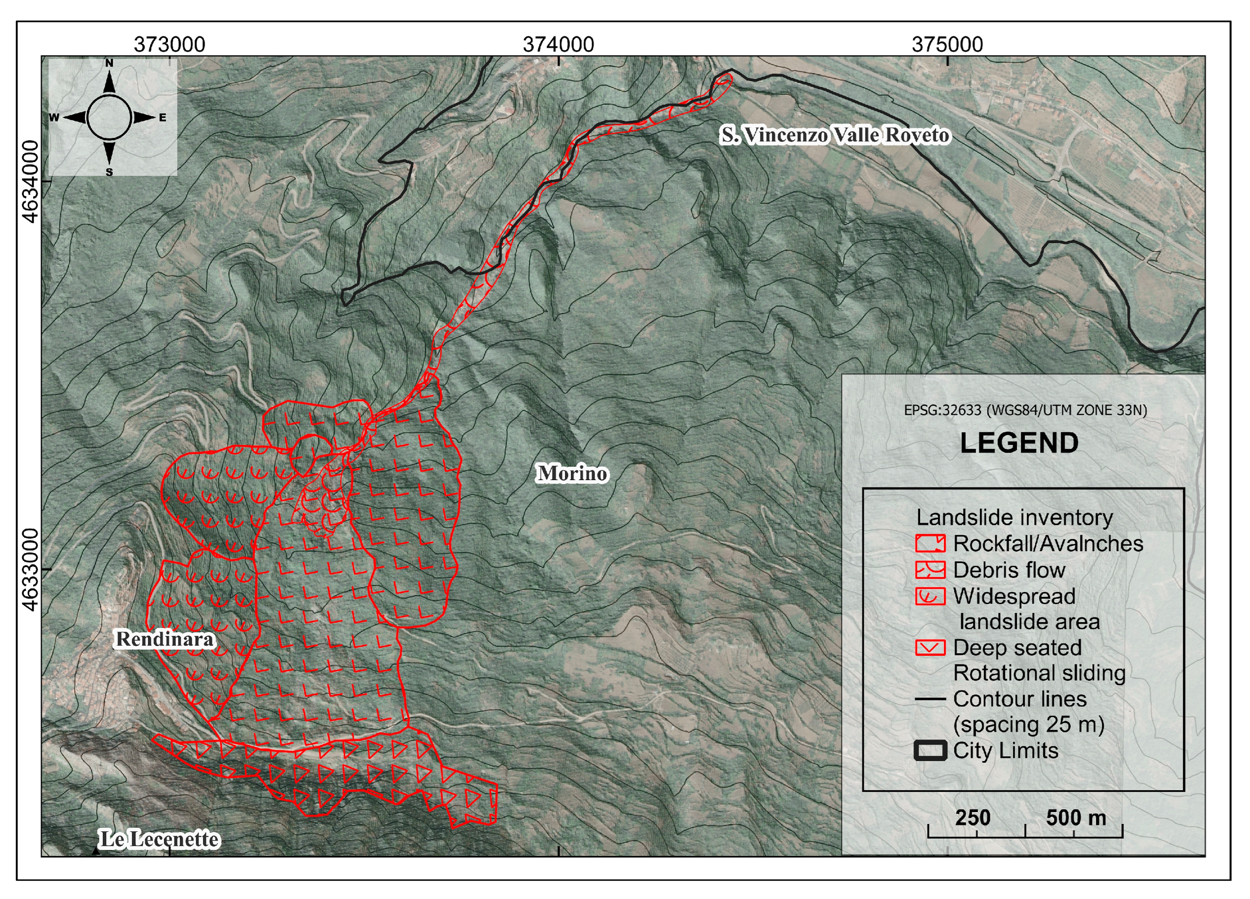
2.1. Field and Geomorphological Interpretation
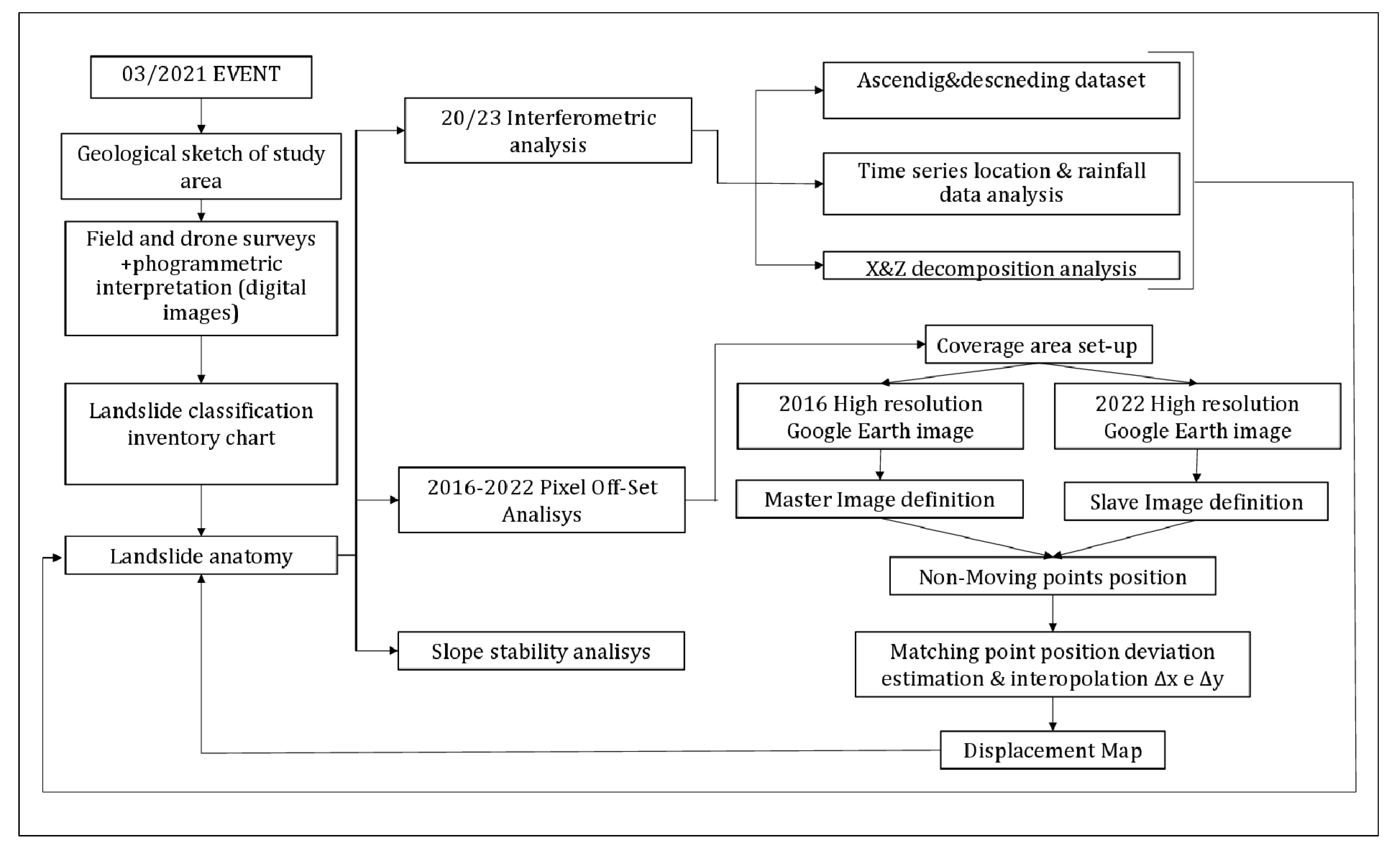
2.2. SAR Interferometry
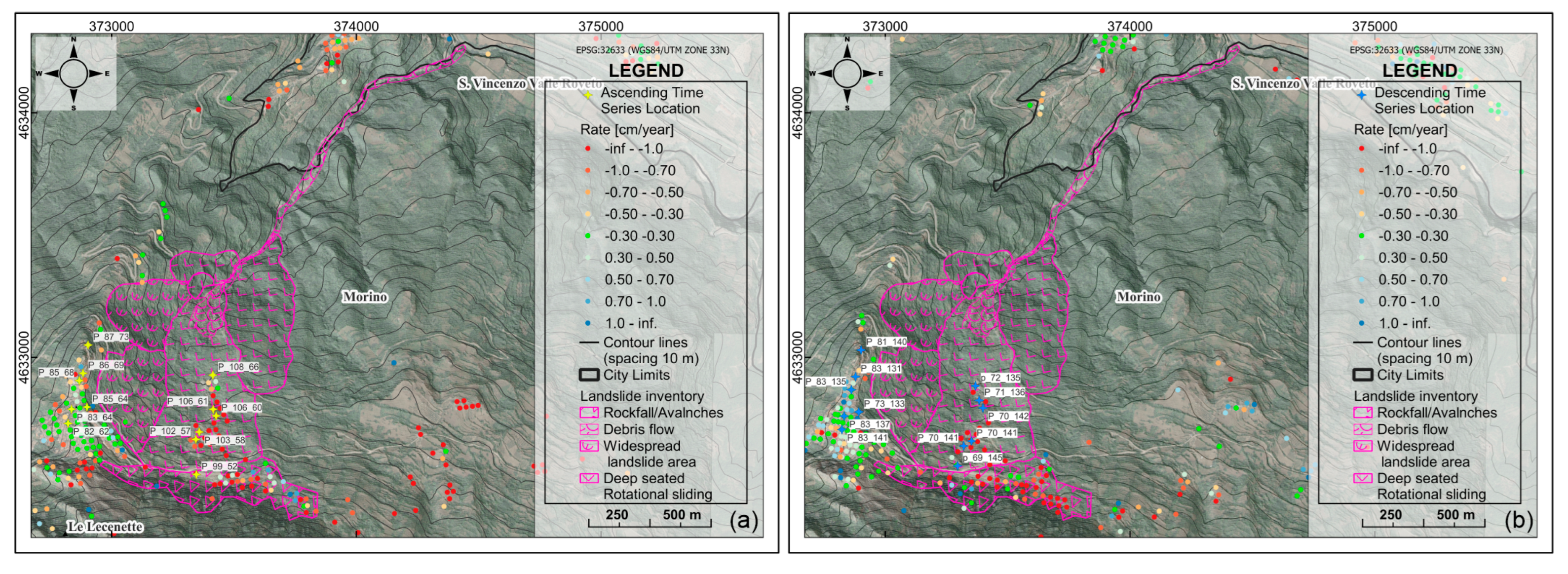
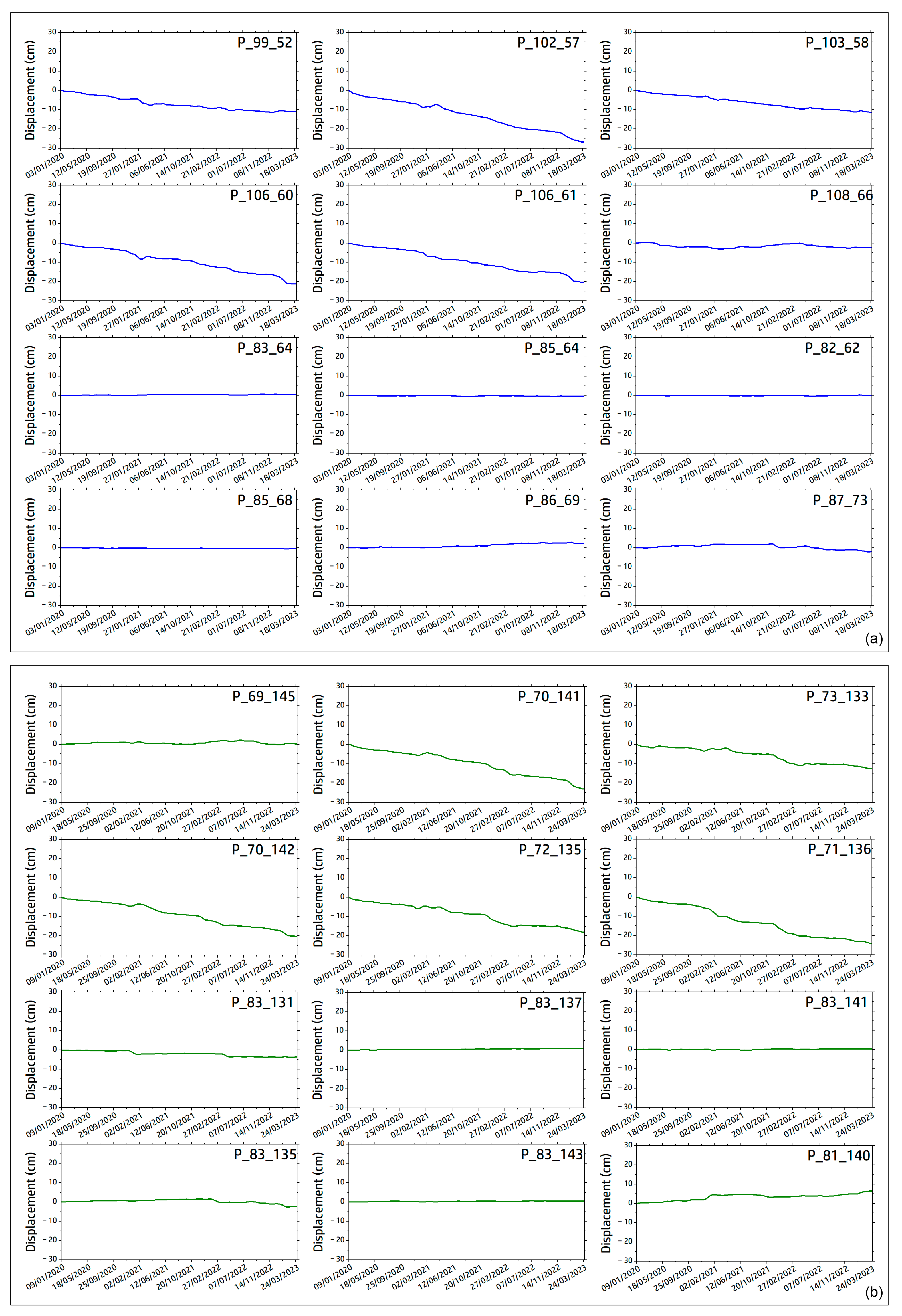
- 96 images acquired in the ascending geometry covering the period from 03-01-2020 to 24-03-2023, with an incidence angle of 39.5° generating 435 interpherograms. The image acquired on 06-09-2021 was automatically set as the master image.
- 107 images acquired in descending geometry covering the period from 09-01-2020 to 30-03-2023, with an angle of 43.6° to the vertical inclination generating 484 interpherograms. The image acquired on 09-03-2021 was automatically set as the master image.
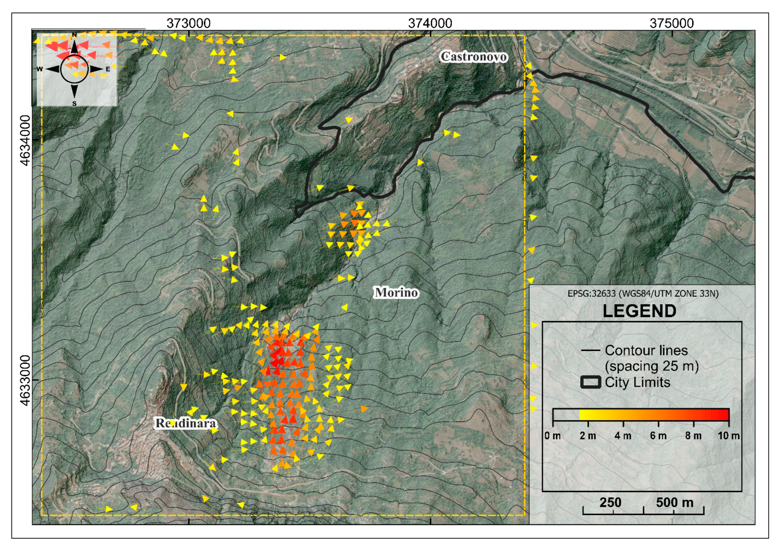
2.3. Pixel Offset
2.4. Rainfall Analyses
2.5. Slope Stability Analysis
3. Results
4. Discussion
5. Conclusions
Author Contributions
Funding
Acknowledgments
Conflicts of Interest
References
- Hungr, O.; Leroueil, S.; Picarelli, L. The Varnes Classification of Landslide Types, an Update. Landslides 2014, 11. [Google Scholar] [CrossRef]
- Kirschbaum, D.B.; Adler, R.; Hong, Y.; Hill, S.; Lerner-Lam, A. A Global Landslide Catalog for Hazard Applications: Method, Results, and Limitations. Natural Hazards 2010, 52. [Google Scholar] [CrossRef]
- Smith, K.; Petley, D.N. Environmental Hazards: Assessing Risk and Reducing Disaster; 2009.
- Wu, Z.; Barosh, P.J.; Ha, G.; Yao, X.; Xu, Y.; Liu, J. Damage Induced by the 25 April 2015 Nepal Earthquake in the Tibetan Border Region of China and Increased Post-Seismic Hazards. Natural Hazards and Earth System Sciences 2019, 19. [Google Scholar] [CrossRef]
- Abbate, A.; Longoni, L.; Ivanov, V.I.; Papini, M. Wildfire Impacts on Slope Stability Triggering in Mountain Areas. Geosciences (Switzerland) 2019, 9. [Google Scholar] [CrossRef]
- Varnes, D. Slope Movement Types and Processes. Special report 1978, 176. [Google Scholar]
- Iverson, R.M.; Reid, M.E.; LaHusen, R.G. Debris-Flow Mobilization from Landslides. Annu Rev Earth Planet Sci 1997, 25. [Google Scholar] [CrossRef]
- Fell, R.; Glastonbury, J.; Hunter, G. Rapid Landslides: The Importance of Understanding Mechanisms and Rupture Surface Mechanics. Quarterly Journal of Engineering Geology and Hydrogeology 2007, 40. [Google Scholar] [CrossRef]
- Iverson, R.M.; George, D.L.; Allstadt, K.; Reid, M.E.; Collins, B.D.; Vallance, J.W.; Schilling, S.P.; Godt, J.W.; Cannon, C.M.; Magirl, C.S.; et al. Landslide Mobility and Hazards: Implications of the 2014 Oso Disaster. Earth Planet Sci Lett 2015, 412. [Google Scholar] [CrossRef]
- Turner, A.K. Social and Environmental Impacts of Landslides. Innovative Infrastructure Solutions 2018, 3. [Google Scholar] [CrossRef]
- Pudasaini, S.P.; Krautblatter, M. The Landslide Velocity. Earth Surface Dynamics 2022, 10. [Google Scholar] [CrossRef]
- Allen, S.K.; Rastner, P.; Arora, M.; Huggel, C.; Stoffel, M. Lake Outburst and Debris Flow Disaster at Kedarnath, June 2013: Hydrometeorological Triggering and Topographic Predisposition. Landslides 2016, 13. [Google Scholar] [CrossRef]
- Usamah, M. Analysis of the Causal and Trigger Factors of the August 2017 Landslide in Freetown : Towards a Sustainable Landslide Risk Management in Sierra Leone; 2017.
- Zito, C.; Mangifesta, M.; Francioni, M.; Guerriero, L.; Martire, D. DI; Calcaterra, D.; Pasculli, A. ; Sciarra, N; Cascading landslide at Morino-Rendinara, L’Aquila, Central Italy: Numerical modelling of slope-scale prospective debris flow propagation. Italian Journal of Engineering Geology and Environment 2024, 285–293. [Google Scholar] [CrossRef]
- Bouzid, D.A. Finite Element Analysis of Slope Stability by Expanding the Mobilized Principal Stress Mohr’s Circles – Development, Encoding and Validation. Journal of Rock Mechanics and Geotechnical Engineering 2022, 14. [Google Scholar] [CrossRef]
- Google Earth Satellitar Images 2023.
- Saroli, M.; Biasini, A.; Cavinato, G.P.; Di Luzio, E. Geological Setting of the Southern Sector of the Roveto Valley (Central Apennines, Italy). Bollettino della Societa Geologica Italiana 2003, 122. [Google Scholar]
- Fabbi, S. Geology of the Eastern Slopes of the Simbruini Mts. Between Verrecchie and Capistrello (Central Apennines – Abruzzo, Italy). J Maps 2018, 14. [Google Scholar] [CrossRef]
- Parotto, M. Stratigrafy and Tectonics of the Eastern Simbruini and Western Marsica Ranges (Central Apennines – Italy. Atti Accademia Nazionale Lincei, Mem 1971, 8, 93–170. [Google Scholar]
- Maceroni, D.; Dixit Dominus, G.; Gori, S.; Falcucci, E.; Galadini, F.; Moro, M.; Saroli, M. First Evidence of the Late Pleistocene—Holocene Activity of the Roveto Valley Fault (Central Apennines, Italy). Front Earth Sci (Lausanne) 2022, 10. [Google Scholar] [CrossRef]
- Cosentino D., C.P. The Messinian Central Apennines. Rendiconti Online Societa Geologica Italiana 2012, 45–51.
- CARG pogect in Geological Itanlian chart 1:100000 Foglio Carta Geologica d’Italia 1:100000 n. 152 Sora Progetto - CARG. 1976.
- Sciarra, N.; Mangifesta, M.; Carabba, L.; Mischiatti, L. Methodological Approach for the Study of Historical Centres of High Architectural Value Affected by Geo-Hydrological Hazards: The Case of Lanciano (Abruzzo Region—Central Italy). Geosciences (Switzerland) 2022, 12. [Google Scholar] [CrossRef]
- Costantini, M.; Ferretti, A.; Minati, F.; Falco, S.; Trillo, F.; Colombo, D.; Novali, F.; Malvarosa, F.; Mammone, C.; Vecchioli, F.; et al. Analysis of Surface Deformations over the Whole Italian Territory by Interferometric Processing of ERS, Envisat and COSMO-SkyMed Radar Data. Remote Sens Environ 2017, 202. [Google Scholar] [CrossRef]
- Mora, P.; Baldi, P.; Casula, G.; Fabris, M.; Ghirotti, M.; Mazzini, E.; Pesci, A. Global Positioning Systems and Digital Photogrammetry for the Monitoring of Mass Movements: Application to the Ca’ Di Malta Landslide (Northern Apennines, Italy). Eng Geol 2003, 68. [Google Scholar] [CrossRef]
- Mallorqui, J.J.; Mora, O.; Blanco, P.; Broquetas, A. Linear and Non-Linear Long-Term Terrain Deformation with DInSAR (CPT: Coherent Pixels Technique). In Proceedings of the European Space Agency, (Special Publication) ESA SP; 2004.
- Guerriero, L.; Di Martire, D.; Calcaterra, D.; Francioni, M. Digital Image Correlation of Google Earth Images for Earth’s Surface Displacement Estimation. Remote Sens (Basel) 2020, 12. [Google Scholar] [CrossRef]
- Zheng, H.; Tian, B.; Liu, D.F.; Feng, Q. Definitions of Safety Factor of Slope Stability Analysis with Finite Element Method. Yanshilixue Yu Gongcheng Xuebao/Chinese Journal of Rock Mechanics and Engineering 2005, 24. [Google Scholar]
- Geraili Mikola, R. ADONIS: A Free Finite Element Analysis Software with an Interactive Graphical User Interface for Geoengineers. Conference: GeoOttawa2017 2017.
- Chen, B. Finite Element Strength Reduction Analysis on Slope Stability Based on ANSYS. Environmental and Earth Sciences Research Journal 2017, 4. [Google Scholar] [CrossRef]
- Quamar, M.M.; Al-Ramadan, B.; Khan, K.; Shafiullah, M.; El Ferik, S. Advancements and Applications of Drone-Integrated Geographic Information System Technology—A Review. Remote Sens (Basel) 2023, 15. [Google Scholar] [CrossRef]
- Iglesias, R.; Mallorqui, J.J.; Monells, D.; López-Martínez, C.; Fabregas, X.; Aguasca, A.; Gili, J.A.; Corominas, J. PSI Deformation Map Retrieval by Means of Temporal Sublook Coherence on Reduced Sets of SAR Images. Remote Sens (Basel) 2015, 7. [Google Scholar] [CrossRef]
- The MathWorks Inc MATLAB 2023 2023.
- Cascini, L.; Fornaro, G.; Peduto, D. Advanced Low- and Full-Resolution DInSAR Map Generation for Slow-Moving Landslide Analysis at Different Scales. Eng Geol 2010, 112. [Google Scholar] [CrossRef]
- Sato, H.P.; Harp, E.L. Interpretation of Earthquake-Induced Landslides Triggered by the 12 May 2008, M7.9 Wenchuan Earthquake in the Beichuan Area, Sichuan Province, China Using Satellite Imagery and Google Earth. Landslides 2009, 6. [Google Scholar] [CrossRef]
- QuantumGis 3. 18 Geographic Information System. QGIS Association 2023.
- Berger M. Geometry I; Springer.; ISBN 3-540-11658-3., 1987.
- Govender, N. Evaluation of Feature Detection Algorithms for Structure from Motion. Csir 2009. [Google Scholar]
- Lucas, B.D.; Kanade, T. Iterative image registration technique with an application to stereo vision.; 1981; Vol. 2.
- Centro Funzionale e Ufficio Idrologia, Idrografico, Mareografico- Agenzia Di Protezione Civile Della Regione Abruzzo.
- Mohammadi, S. Extended Finite Element Method: For Fracture Analysis of Structures; 2008.
- Guerriero, L.; Guadagno, F.M.; Revellino, P. Estimation of Earth-Slide Displacement from GPS-Based Surface-Structure Geometry Reconstruction: Estimation of Earth-Slide Displacement. Landslides 2019, 16. [Google Scholar] [CrossRef]
- Gabriel, A.K.; Goldstein, R.M.; Zebker, H.A. Mapping Small Elevation Changes over Large Areas: Differential Radar Interferometry. J Geophys Res 1989, 94. [Google Scholar] [CrossRef]
- Casagli, N.; Catani, F.; Del Ventisette, C.; Luzi, G. Monitoring, Prediction, and Early Warning Using Ground-Based Radar Interferometry. Landslides 2010, 7. [Google Scholar] [CrossRef]
- Di Martire, D.; Novellino, A.; Tessitore, S.; Ramondini, M.; Calcaterra, D. Application of DInSAR Techniques to Engineering Geology Studies in Southern Italy. Rendiconti Online Societa Geologica Italiana 2013, 24. [Google Scholar]
- Morgenstern, N.R.; Price, V.E. Morgenstern, N.R. and Price, V.E. (1965) The Analysis of the Stability of General Slip Surfaces. Géotechnique, 15, 79-93. 1st Panamerican Conf. SMFE 1965, 2. [CrossRef]
- Bianchini, S.; Solari, L.; Bertolo, D.; Thuegaz, P.; Catani, F. Integration of Satellite Interferometric Data in Civil Protection Strategies for Landslide Studies at a Regional Scale. Remote Sens (Basel) 2021, 13. [Google Scholar] [CrossRef]
- Khandelwal, D.D.; Gahalaut, V.; Kumar, N.; Kundu, B.; Yadav, R.K. Seasonal Variation in the Deformation Rate in NW Himalayan Region. Natural Hazards 2014, 74. [Google Scholar] [CrossRef]
- Guo, Z.; Ferrer, J.V.; Hürlimann, M.; Medina, V.; Puig-Polo, C.; Yin, K.; Huang, D. Shallow Landslide Susceptibility Assessment under Future Climate and Land Cover Changes: A Case Study from Southwest China. Geoscience Frontiers 2023, 14. [Google Scholar] [CrossRef]
- Van den Bout, B.; Lombardo, L.; Chiyang, M.; van Westen, C.; Jetten, V. Physically-Based Catchment-Scale Prediction of Slope Failure Volume and Geometry. Eng Geol 2021, 284. [Google Scholar] [CrossRef]
| Ascending | Descending | Applied Formula |
|---|---|---|
| Yes | Yes | |
| Yes | No | |
| No | Yes |
| Parameter | Mesozoic Limestone | Messinian Clay | Cover Layer |
| Unit weight (kg/m3) | 2750 | 2200 | 2300 |
| Young (Pa) | 1.2 e+10 | 3.1+09 | 1.5+09 |
| Poisson | 0.30 | 0.25 | 0.25 |
| Θ( ͦͦ) | - | - | 27 |
| c (Pa) | - | - | 18000 |
| Type | Iso-elastic | Iso-elastic | Mohr Coulomb |
| Shear Modulus (Pa) | 4.61e+09 | 1.24e+09 | 6e+08 |
| Bulk Modulus (Pa) | 1e+10 | 2.06e+09 | 1e+09 |
Disclaimer/Publisher’s Note: The statements, opinions and data contained in all publications are solely those of the individual author(s) and contributor(s) and not of MDPI and/or the editor(s). MDPI and/or the editor(s) disclaim responsibility for any injury to people or property resulting from any ideas, methods, instructions or products referred to in the content. |
© 2024 by the authors. Licensee MDPI, Basel, Switzerland. This article is an open access article distributed under the terms and conditions of the Creative Commons Attribution (CC BY) license (http://creativecommons.org/licenses/by/4.0/).


