
Submitted:
12 August 2024
Posted:
13 August 2024
You are already at the latest version
Abstract
Accurate fire severity mapping is essential for understanding the impacts of wildfires on vegetation dynamics in arid savannas. The frequent wildfires in these biomes often cause topkill, where vegetation experiences above-ground combustion, but the below-ground root structures survive, allowing for subsequent regrowth post-burn. Investigating post-fire regrowth is crucial for maintaining ecological balance, elucidating fire regimes, and enhancing the knowledge base of land managers regarding vegetation response. This study examined the relationship between bush fire severity and post-burn coppicing/regeneration events of woody vegetation in the Kalahari Desert of Botswana. Utilizing UAV-derived RGB imagery combined with a Random Forest (RF) classification algorithm, we aimed to enhance the precision of burn severity mapping at a fine spatial resolution. Our research focused on a 1 km2 plot within the Modisa Wildlife Reserve, extensively burnt by the Kgalagadi Transfrontier Fire of 2021. The UAV imagery, captured at various intervals post-burn, provided detailed orthomosaics and canopy height models, facilitating precise land cover classification and burn severity assessment. The RF model achieved an overall accuracy of 79.5% and effectively identified key burn severity indicators, including green vegetation, charred grass, and ash deposits. Our analysis revealed a >50% probability of woody vegetation regrowth in high severity burn areas six months post-burn, highlighting the resilience of these ecosystems. This study demonstrates the efficacy of low-cost UAV photogrammetry for fine scale burn severity assessment and provides valuable insights into post-fire vegetation recovery, thereby aiding land management and conservation efforts in savannas.
Keywords:
Random Forest
; burn severity
; UAV
; Kalahari
; remote sensing
; savanna
; machine learning
; wildfire
1. Introduction
Africa is often referred to as the “Fire Continent”, as African savanna fires account for over 60% of annual area of global fire extent [1,2]. Fire is an integral part of African savanna ecosystems and includes ignitions from both natural (e.g., lightning) and anthropogenic sources [3]. The effect of fire in savannas depends upon the type and intensity of fire, and the season and frequency of burning (i.e., fire regime) [4]. Compared to other ecoregions, savanna fires are typically of lower intensity yet occur more frequently [1,3] which can be attributed to the rapid regrowth rates of grasses, which serve as the primary fuel for these fires, leading to short fire return intervals [4,5] and low-intensity surface fires [3,6,7,8]. The fire intensity and frequency may alter the long-term woody/grass cover ratio, woody height profile, and surface albedo [3,6,7]. Surface fires predominantly consume the grass layer, leaving the woody canopy largely unscathed as the flames seldom extend to the canopy [1,9]. Higher intensity fires predominantly impact woody vegetation in savannas by damaging vegetations’ internal stem structures rather than via canopy damage [10,11]. The result is topkill (death of aerial biomass) which results in coppicing (or regenerate/resprout) from the collar region of the stem [12]. Fire damage in savannas is seldom enough to cause whole-plant mortality [8,11]. Woody vegetation in African savannas, including in the Kalahari, therefore exhibits a high level of resilience to individual fires due to their low mortality rates and rapid resprouting patterns post-burn [12,13].
Discerning total tree mortality versus survival post burn is difficult due to surviving below-ground biomass that is not easily detectable with standard surveying techniques. Woody vegetation that has lost significant amounts of total above-ground biomass is often fully intact below the ground surface [10,12]. Land managers frequently observe a phenomenon referred to as ‘ghost logs,’ where trees have fully combusted, leaving only a white ash outline of the tree. These ghost logs have been seen to demonstrate significant rates of resprouting from surviving root structures post-burn [14]. Coppicing of woody vegetation therefore poses a challenge in quantifying the post-burn vegetative response.
In the Kalahari, understanding burn severity (i.e., the extent to which fire causes mortality in aboveground vegetation and alters soil properties and belowground processes [15,16,17]) is particularly important due to its direct impact on the survival rates of woody vegetation [10,13,18]. The region has experienced significant shrub encroachment, characterized by the expansion of shrubs at the expense of grasses, which represents an ecological regime shift [19,20] that threatens the livelihoods of local communities dependent upon grazing [5,21]. Shrub encroachment is driven by factors such as overgrazing, fire suppression, changes in precipitation, and increased CO2 [5,13]. Natural fire regimes mitigate woody encroachment by preventing shrub establishment, with prescribed burning aiming to maintain open savannas [1,13,20,22]. Understanding post-fire vegetation response and recovery patterns is essential for informed management decisions, particularly in assessing the efficacy of fire in combating shrub encroachment.
Many studies have focused on the effects of low-intensity prescribed fires [9,13,20,21]. Here, we investigate the impacts of higher-intensity wildfires on post-burn woody vegetation responses [9,13,23] using UAV-derived imagery that should provide information about burn severity. Previous studies have classified burn severity utilizing spectral parameters derived from multi- and hyperspectral satellite and aerial imagery [24,25,26]. A common method involves computing the difference between pre-fire and post-fire Normalized Burn Ratio (NBR), which employs the near-infrared (NIR) and shortwave infrared (SWIR) bands [25,27]. In the Kalahari, the immediate post-burn response in high severity fires is predominantly characterized by white ash deposits, which increase surface albedo [6,7,9]. This challenges the effectiveness of NBR in this region, as highlighted by Roy [28], who critiqued its sensitivity in these conditions. Smith detailed difficulties in using NBR indices for accurately classifying burn severity in Northern Botswana, particularly due to struggles to capture the fine scale of ash deposits and the unique spectral signatures of white ash within the NBR model [29]. We address these challenges by investigating alternative methods to enhance burn severity classification in regions characterized by white ash deposits.
Driven by the need for finer spatial resolution in burn severity classification, unmanned aerial vehicles (UAVs) present a cost-effective, on-demand remote sensing solution capable of detecting fine-scale white ash deposits. Globally, studies have successfully utilized UAVs to classify burn severity with high accuracy, showcasing their effectiveness across diverse environments [24,26,30,31]. However, within the Kalahari and Southern Africa more broadly, UAVs have yet to be employed for this purpose; previous research has primarily relied on satellite imagery for classification [29,32].
This research aims to determine the relationship between bush fire severity and post-burn coppicing/regeneration events in the Kalahari Desert in Southern Botswana providing insight for researchers and land managers into the likelihood of post-burn regeneration by establishing a framework for estimating mortality rates and future succession patterns in the landscape [33]. Quantification of post-burn woody vegetation regeneration rates is crucial for furthering the understanding of the effect of fire on vegetation composition and community shifts in the Kalahari [33]. Traditional satellite imagery’s limited resolution and temporal constraints often fail to capture the fine-scale effects of fire events and their immediate aftermath [27,30]. To address these challenges, we utilized UAV-derived RGB imagery, a novel approach in this region, combined with machine learning techniques to achieve more precise and timely burn severity classifications.
2. Materials and Methods
2.1. Study Area
This study was conducted at the Modisa Wildlife Reserve in the Kalahari Desert in the Kgalagadi District of Southern Botswana, an arid savanna ecosystem [5,7,10]. Rainfall is highly seasonal, with an annual mean of less than 300 mm that falls almost exclusively between October and April [5,34]. These conditions favor the growth of savanna open grassland vegetation, which is comprised of a mix of perennial and annual grasses, with occasional shrubs and few trees [34]. The soil composition is predominantly Kalahari sand [34,35]. In this region, the principal uses of land are wildlife conservation/tourism and pastoral ranching, with roughly a third of the district’s total land area incorporated into the Kgalagadi Transfrontier Park [32,35]. Fire is common and tends to occur late in the dry season when grasses have low moisture content and ignite readily [9,21].
Modisa Wildlife Reserve (Figure 1) consists of a 7,000 hectares private wildlife area in the Kalahari Desert [36]. Modisa serves as an ideal study site given its effective wildlife management and controlled grazing, presenting it as a model of a healthy savanna ecosystem. The property has no history of cattle grazing and has only experienced native ungulate grazing and browsing. During the 2021 dry season, a large fire, the Kgalagadi Transfrontier Fire (KTF), burnt a large portion of the reserve. It (Figure 1) was ignited by anthropogenic sources in August 2021 and lasted through late September of 2021, burning over 4 million hectares of land [32]. The fire presents an opportunity to scrutinize the ecological impacts of high-intensity wildfires. Unlike prescribed fires, which are controlled and of lower intensity, the unanticipated nature and scale of this wildfire afforded a rare perspective on the dynamics of fire behavior and its consequent effects on the ecosystem. A recent study by Kaduyu [32] used the Landsat Fire Mapping Tool to estimate total burn severity for the fire extent, overall claiming low severity estimates for the fire. However, Kaduyu primarily focused on large scale severity classifications rather than fine-scale methodologies that have been seen in previous studies to better fit the fine scale resolution needs of post-burn mapping in the Kalahari [32].
This research concentrates on a 1 km2 plot of land (center point: -26.1817348°N, 21.8504333°E) within the Modisa Wildlife Reserve, entirely burnt by the Kgalagadi Transfrontier Fire (Figure 2). The plot was randomly selected after the fire and consists of a mixture of shrubs and trees, grasses, and sparse herbaceous cover displaying a range of burn severities (Figure 2).
2.2. Approach
The approach for classifying burn severity involved four main components outlined in the Figure 3 flow diagram: 1) UAV image collection and processing, 2) input supervised classification, texture, canopy height model, and RGB spectral variable calculations, 3) Random Forest modeling and accuracy assessment, 4) final burn severity mapping.
2.3. UAV Image Collection & Image Processing
UAV imagery has demonstrated the ability to capture spatial variability in heterogeneous burned areas compared to high-resolution satellite imagery [24,27,30]. Unlike satellite imagery, UAV image acquisition isn’t subject to timing constraints imposed by orbital dynamics and can thus provide images at any time while also offering potential for high spatial resolution sampling that is critical for assessing spatial variations in burn severity [1,26]. This is particularly important in the Kalahari, where the temporal detection window for white ash is narrow.
We acquired post-fire imagery across the 1-km2 study areas in Modisa in both dry and wet seasons to facilitate a comparative analysis of woody vegetation regrowth (September 2021–December 2023) (Table 1). By examining a sample of woody vegetation captured in the initial imagery 12 hours post-burn and subsequently tracking their development through following the fire, this approach enabled a detailed assessment of vegetative recovery. The image collected 12 hours post-burn served as the primary dataset for the burn severity classification model. The subsequent imagery was utilized in the analysis of vegetation regrowth, allowing for a comprehensive assessment of recovery patterns over time.
Images were captured using a DJI Mavic 2 Dual Enterprise with a 48 MP RGB camera. DroneDeploy software (v 2.422.0; DroneDeploy Inc., San Francisco, CA) was used to plan autonomous flights at 75 m above ground level in a grid pattern, to capture nadir imagery with ~5 cm resolution, 85% forward overlap, and 70% side overlap. These images were processed within DroneDeploy into dense 3D point clouds, Digital Surface Models (DSMs), Digital Elevation Models (DEMs), and color orthomosaics, all at 5 cm resolution using DroneDeploy’s structure from motion (SfM) algorithms [25]. Orthomosaics were accurately georeferenced by leveraging the GPS data tagged by the drone’s onboard GPS system during image capture. After generating the DEM and the DSM from the point cloud data within DroneDeploy, a Canopy Height Model (CHM) was created by subtracting the DEM (representing the ground elevation) from the DSM (indicating the elevation of the surface including vegetation). The CHM was instrumental in assessing the vertical structure of the vegetation, allowing for the quantification of the distribution of vegetation height post-burn. To ensure precise alignment of drone images taken at different times, a co-registration process was performed using manually identified ground control points in ArcPro, aligning all images to a common coordinate system.
2.4. Burn Severity Classification
In burn severity classifications there is often an underlying assumption that surface albedo decreases following a fire [6,7,29] and previous research using coarse imagery has centered on finding the minimum albedo after fire [7]. However, this assumption may not hold where two types of ash can be observed: white ‘mineral’ ash from complete combustion, and darker ‘black’ ash or char with unburned fuel components [14,29,37].
Given the fine resolution of UAV imagery and evidence of limited success of spectral based methodologies such as NBR in the Kalahari [28,29], biophysical parameters rather than spectral parameters were used as the primary indicators of burn severity during the manual classification dataset creation. The high-resolution UAV-derived orthomosaics allows for the effects of fires to be discernibly classified by the human eye. Thus, we manually classified land cover into categories aligned with specific burn severity classifications to produce a training dataset that could be used to train a machine learning model. This method, diverging from previous studies that predominantly utilized spectral indices when classifying burn severity from drone imagery, takes advantage of drone imagery’s finer resolution to evaluate the effectiveness of biophysical indicators [24,25,26,30].
We used six land cover classifications (including shadow’s null classification) with corresponding burn severity rankings in this classification (Table 2) including four indicators of burn severity (green vegetation, burnt woody vegetation, charred grass, and ash deposits) that could be easily distinguished within the RGB imagery (Figure 4) [14,25]. Burnt woody vegetation was defined as standing vegetation that experienced partial scorching on the trunk and canopy, leading to an overall loss of green vegetation, but received no structural damage. Ash was defined as: white ash, which represented fully combusted vegetation with minimal residual organic material, and gray ash, which consisted of a mixture of fully combusted vegetation and partially combusted plant material. Charred grass was defined as grass that had been burned, resulting in a blackened appearance due to partial combustion, while retaining some structural integrity unlike ash. Green vegetation was classified as standing, green woody vegetation that received little to no fire damage. Bare soil was classified as uncharred parts of the bare ground.
UAV images taken in the 12-hour post-burn image were acquired early in the morning (approximately 9 am), which led to a considerable shadows within the image, necessitating a tailored approach for accurate analysis. An initial attempt to mask shadows by thresholding the orthomosaic’s red band as documented in Fraser [25] proved overly broad, inadvertently masking charred grass and burnt woody vegetation due to their similar spectral signatures. This resulted in significant data loss within the model. To mitigate this, shadows were classified as a distinct category in the classification process, aiming to isolate their effects and ensure a more accurate representation of the post-burn landscape.
Focusing on woody vegetation, we applied a ternary assessment model for evaluating burn severity, categorizing it as either unburnt, low severity, or high severity. This model aligns with the findings and recommendations of Edwards & Russell-Smith [38] and McKenna [26], who argue for the applicability of a simplified binary or ternary classification in savanna ecosystems. Such environments are characterized by sparsely populated canopy covers, thereby making a ternary classification both relevant and efficient [38]. While we also acknowledged the presence and significance of charred woody grass by assigning it a medium severity classification, the core emphasis of our research was on woody vegetation.
2.5. Supervised Classification - Training Dataset
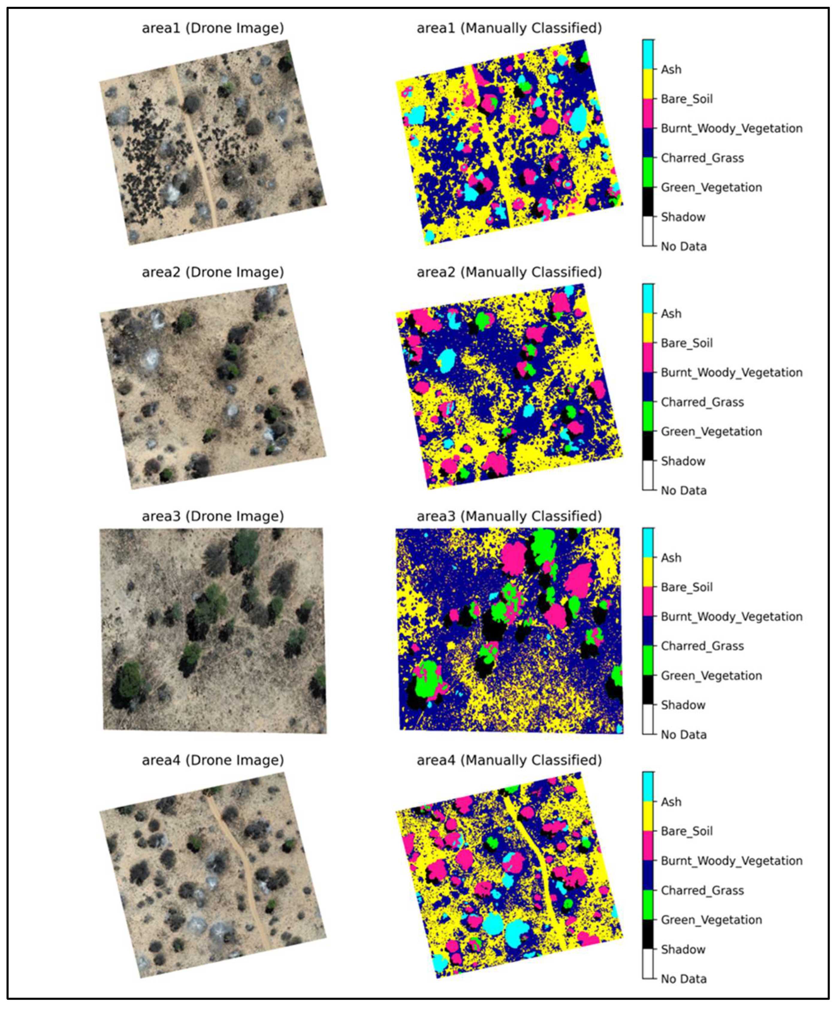
A manually digitized training dataset, corresponding to our land cover classes (Table 2), was created using ArcPro (v3.1.3). The training dataset for land cover classifications was developed through the manual visual analysis of UAV-derived orthomosaics. Four randomly located and non-overlapping 100 m x 100 m areas were extracted from the 12 hour post-burn RGB orthomosaics and digitized by a single observer (M. Gillespie).
Figure 5.
Original RGB drone images (left) and the manually classified land cover classifications (right).
Figure 5.
Original RGB drone images (left) and the manually classified land cover classifications (right).
2.6. Random Forest Classification and Input Variables
This study implemented the Machine Learning (ML) Random Forest (RF) algorithm for burn severity classification. ML techniques have proven to be superior to simple classifiers, particularly in navigating the complexities of scene scale and interaction, and in distinguishing classes within heterogeneous landscapes [39,40]. These landscapes, typical in remote sensing, often feature low separability between different classes and high variability within the same class [27,40]. RF, in particular, has the following advantages in burn severity mapping: it handles categorical predictors naturally, it is computationally simple to fit, it can consider multiple environmental variables simultaneously, and it can handle outliers and noise with relative ease [40,41,42]. Despite the commonly cited advantages of ML classifiers like RF, they have rarely been utilized for burn severity classification within the literature [27,43].
RF is known for its stable and robust accuracy in classifying land cover due to its proficiency in managing large, high-dimensional datasets by constructing decision trees through boot-strap aggregated sampling (bagging) of training data [40,44,45]. It enhances prediction accuracy via ensemble voting, where each tree evaluates a random subset of predictor variables at each split to maximize data homogeneity [27,28,41]. We utilized the Scikit-Learn package in Python (version 3.1.0). Based on the recommendations of previous studies and pretests from the dataset, the ‘ntree’ parameter, denoting the number of decision trees in the ensemble, along with the ‘mtry’ parameter, indicating the number of features to consider for splitting at each node, were set to 100 and ‘default’, respectively [45,46]. Additionally, a bootstrap parameter was used to increase variability and diversity during the construction of individual trees in the model, helping prevent overfitting and improving its robustness and generalization to different land cover classifications [40,46]. We used a 70-30 training-testing split where 70% of the data points were selected for training while the remaining 30% of data points were reserved for testing. Feature importance in the Random Forest model was quantified using the Scikit-Learn library, based on the average decrease in Gini impurity attributed to each feature across all decision trees in the ensemble.
Predictor data included an array of spectral indices, elevation data, texture features, and individual RGB band information. Training variables were strategically selected for their proven efficacy in capturing the nuanced dynamics of land cover, with a particular emphasis on differentiating burn severity (Table 3). The EGI and GCC indices were chosen for their ability to discriminate green vegetation from all other land cover types. Both indices have been documented in previous burn severity classification studies to be effective at delineating green vegetation from burned areas [25,26]. Introduced by Fraser [25], the Char Index (CI) was developed specifically to detect charred organic surfaces from RGB imagery. This composite index employs both the Brightness Index (BI) and the Maximum RGB Difference Index (MaxDiff) for the purpose of distinguishing charred areas within an image. The CI’s foundation lies in the recognition that surfaces impacted by charring exhibit very low reflectance in the visible spectrum, as measured by the BI, along with a uniform visible reflectance spectrum, leading to a notable absence of color, which is assessed using MaxDiff [25]. Subsequent studies, including those by Beltrán-Marcos [24] and Von Nonn [31], have successfully applied the CI for classifying burn severity in RGB-UAS-derived imagery, demonstrating high levels of accuracy.
Numerous studies and practical applications have documented the effectiveness of combining spectral and textural information for land cover classification [47,48]. Several texture features derived from a Gray-Level Co-occurrence Matrix (GLCM) were calculated and implemented into the model including Contrast, Energy, Homogeneity, and Correlation (Table 3). GLCM features capture textural information by examining the spatial relationships between pixel intensities in an image, which can provide valuable information about the surface characteristics [49,50]. Combining GLCM texture features with spectral indices served to enhance the RF’s effectiveness by adding spatial details to the spectral information. Spectral indices capture the condition of the surface, such as vegetation health and burn extent, while GLCM texture features provide a detailed understanding of the area’s spatial patterns [49,50]. The Gray comatrix package within Python’s Scikit-Learn Library was used to compute the texture features. A distance of 5 pixels was set during computation in which the GLCM looked at pixel pairs that were 5 pixels apart horizontally. This parameter was appropriate given the high resolution of the drone imagery used within our study. A CHM was constructed from 3D point clouds in the drone imagery processing steps of this study. This integration of CHM data into the model allowed for a more nuanced differentiation between burned and unburned trees, leveraging variations in canopy height to discern standing trees with greater precision.
To quantify the RF model’s uncertainty, a Monte Carlo simulation was conducted to generate different model severity outputs [51,52]. This approach aligns with established methodologies, as demonstrated by Li [52], who used Monte Carlo simulations to enhance the robustness of their RF classification for above-ground biomass estimations in forests, and by Coulston [51] and Wang [53], who highlighted the value of Monte Carlo simulations in quantifying uncertainty and improving the accuracy and reliability of predictive models and environmental data interpretations in remote sensing applications. This approach involved introducing a controlled level of variability into the training data to simulate potential inaccuracies and real-world data variations. Specifically, a custom Python function was developed to randomly alter 5% of the classified burn severity data in each iteration, changing them to represent another possible burn severity class. By creating 1,000 different training datasets with these slight variations and training a separate RF model for each dataset, we were able to generate 1,000 different burn severity classification outputs. This process allowed us to assess the model’s sensitivity to changes in the training dataset and to estimate the variability in its predictions.
The initial accuracy assessment was conducted using the unaltered training dataset to establish a baseline performance of the RF model. This baseline provided a reference point for evaluating the impact of introducing variability in the training data. The accuracy metrics obtained from this initial assessment were used for model accuracy analysis and the creation of the final severity map.
2.7. Woody Vegetation Survival/Regrowth Analysis
To assess the survival and regrowth of woody vegetation post-burn, drone imagery from two subsequent growing seasons were analyzed to manually detect green vegetation. Imagery from 6 months and 2.5 years post-burn were visually examined to determine if a random sample of trees within the study area exhibited regrowth in the growing seasons following the fire. The 1 sq. km plot was divided into 100 plots of 100 square meters each, with 500 randomly generated points assigned across these plots (5 points per plot). A random sample of 500 woody vegetation patches were selected for visual analysis. Due to the overlapping canopy and close establishment patterns of woody vegetation, a patch-based analysis was employed to assess survival, as individual trees were difficult to identify without ground-truth data.
For each woody patch, the model’s predicted classification was recorded. The co-registered drone imagery from 6 months and 2.5 years post-burn were then analyzed to observe the survival status of each patch, specifically looking for green regrowth as an indicator of survival. Given the limited species diversity and sparse canopy cover in the study area, distinguishing woody vegetation regrowth from other vegetation forms was straightforward within the high-resolution drone imagery (Figure 6). Herbaceous cover, as compared to woody vegetation, displays distinct hues of green within the imagery, allowing for easy categorization of woody vegetation regrowth versus other vegetation forms.
The probability of woody vegetation survival and subsequent regrowth at 6-months and 2.5 years post-burn for each burn severity classification was calculated based on the regrowth observations derived from the 500-tree patch sample. Utilizing the Monte Carlo simulation outputs as previously detailed, probability was then calculated over all 1,000 burn severity classification outputs derived from the Monte Carlo simulation to provide a robust understand of the likelihood of woody vegetation survival and regrowth across a multitude of different model outputs.
These probabilities were collected and analyzed to derive the mean and standard deviation of regrowth outcomes for each burn severity classification across all simulations. This comprehensive approach allowed for an assessment of how variations in burn severity classification accuracy might influence the understanding of regrowth patterns, thereby enhancing the reliability of the model’s outputs. Violin plots were constructed in Python to visualize the probability distribution of woody vegetation regrowth within the Monte Carlo simulation.
3. Results
3.1. Burn Severity Classification
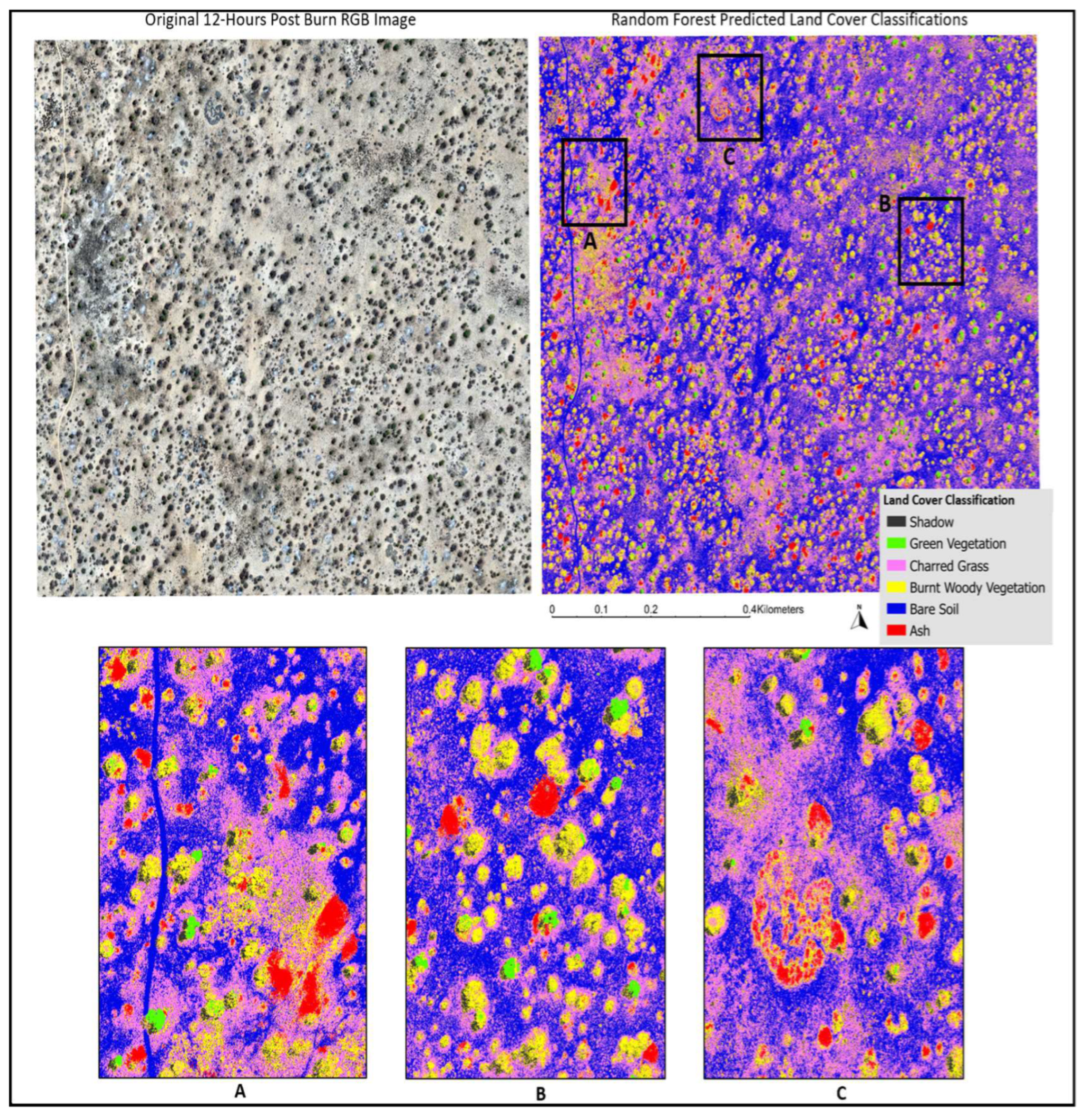
A visual analysis of the final classified image indicates a strong correspondence between the original RGB image and the classified image, particularly in the accurate identification of woody vegetation (Figure 8). This agreement underscores the effectiveness of RF in distinguishing between different land cover types within the study area. However, some limitations were observed. Notably, there is evidence of salt-and-pepper noise, predominantly within the bare soil and charred grass classifications, indicating pixel-level misclassifications. The classification of shadow in the final image also was seen to experience levels of salt-and-pepper noise, often being misclassified as charred grass or charred woody vegetation.
Figure 7.
Random Forest Classification results reclassified to represent burn severity rankings.
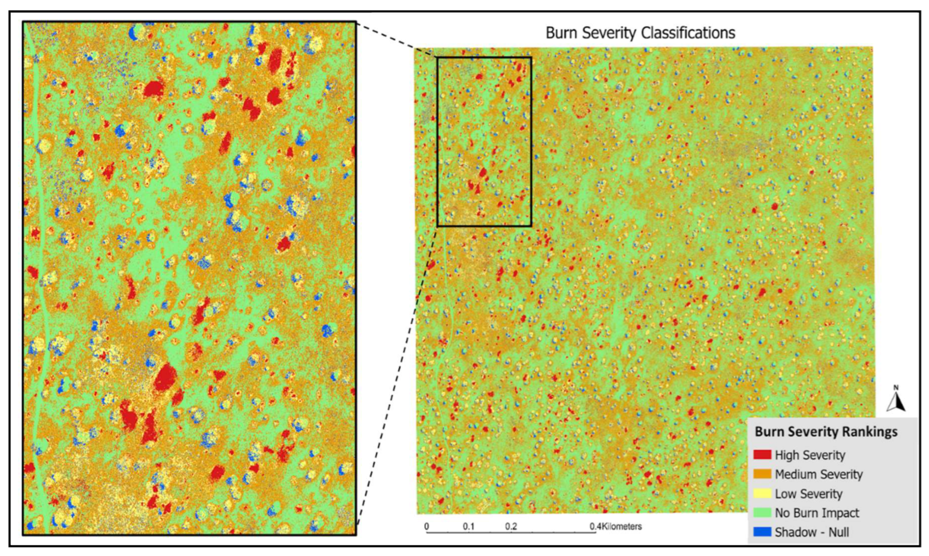
Figure 8.
Top Panel: Original drone image 12-hours post burn (left) and the Random Forest Model predicted land cover classification map (right). 3 outlined regions (A, B, C) are indicated. Bottom Panel: The zoomed in regions from the model predicted map for better visualization.
Figure 8.
Top Panel: Original drone image 12-hours post burn (left) and the Random Forest Model predicted land cover classification map (right). 3 outlined regions (A, B, C) are indicated. Bottom Panel: The zoomed in regions from the model predicted map for better visualization.
The final reclassified burn severity map (Figure 7) illustrates the overall burn severity of the 2021 Kgalagadi Transfrontier Fire, predominantly characterized by low to medium severity burns. The landscape is primarily dominated by bare soil and charred grass regions, with only a few areas exhibiting high severity burns, marked by the presence of combusted woody vegetation (ash). Notably, the northwestern corner of the study area, as highlighted in Figure 7 and Figure 8, shows a significant concentration of high severity burn areas compared to the rest of the study plot.
The final RF model was trained using over 20 million pixels and achieved an overall F-score of 0.73 and an overall accuracy (OA) of 79.5%. Green vegetation yielded the highest F1-score of 0.90, indicating a strong concordance between the training dataset and RF predicted classifications (Table 4). Notably, despite having the smallest sample size (210,213 pixels), green vegetation’s high F1-score underscores the model’s robustness in this class. In contrast, burnt woody vegetation exhibited the lowest performance with an F1-score of 0.51. The other land cover classes—shadow, bare soil, ash, and charred grass—demonstrated intermediate accuracy, with F1-scores between 0.69 and 0.78 (Table 4). The confusion matrix (Figure 9) reveals the model’s difficulty in accurately predicting burnt woody vegetation, frequently misclassifying it as charred grass. Similar misclassification patterns were observed for shadow, bare soil, and ash, which were often incorrectly classified as charred grass.
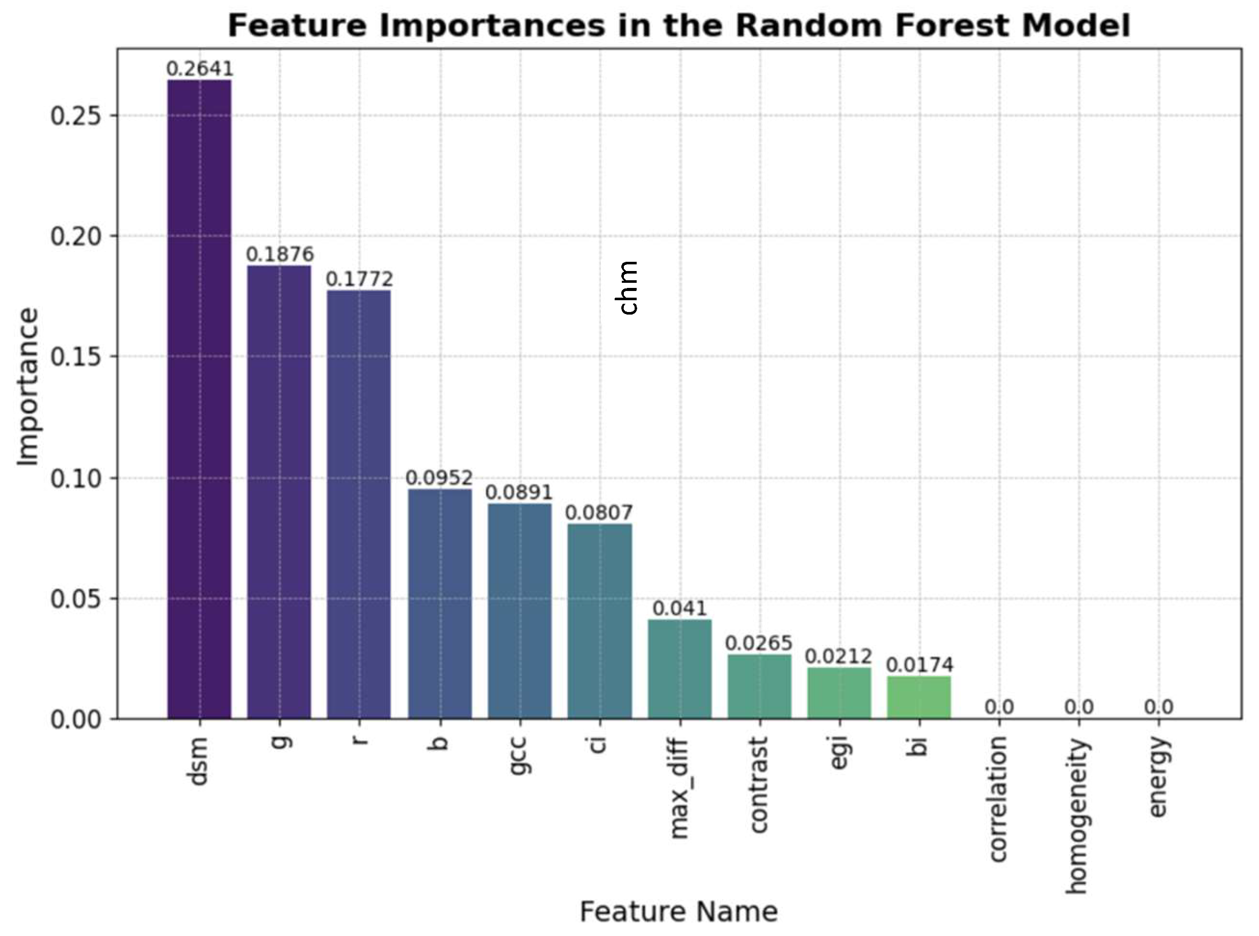
3.2. Relative Importance of Model Predictors
Elevation data proved to be the most influential feature within the model, followed by the individual RGB bands as the second most significant predictors, with the Green band showing the highest importance. Among the RGB spectral indices, the GCC was the most significant for land cover classification. In an attempt to better distinguish burnt woody vegetation from charred grass, texture features were added to the predictor dataset with the expectation that the standing woody vegetation would be better separated from the charred soil and grass. Despite previous studies’ success in employing GLCM texture features in land cover classifications [48,54], our study saw little to no positive effect in regard to the addition of texture variables, with correlation, homogeneity, and energy displaying minimal feature importance in the model.
Figure 10.
Feature importance within the Random Forest Classification Model. CHM = Canopy Height Model; RGB = Red band, green band, blue band; GCC = Green Chromatic Coordinate; CI = Char Index; max_diff = Max Difference Index; EGI = Excessive Greenness Index; BI = Brightness Index.
Figure 10.
Feature importance within the Random Forest Classification Model. CHM = Canopy Height Model; RGB = Red band, green band, blue band; GCC = Green Chromatic Coordinate; CI = Char Index; max_diff = Max Difference Index; EGI = Excessive Greenness Index; BI = Brightness Index.
3.4. Woody Vegetation Survival/Regrowth Probabilities
Woody vegetation patches that experienced high severity burns as indicated by ash cover experienced the lowest likelihood of survival/regrowth post-burn compared to burnt woody vegetation and un-impacted green vegetation (Figure 11). At 6-months post-burn, high severity patches saw a ~54% probability of survival/regrowth, low severity patches saw an 85% probability of survival/regrowth, and unimpacted areas of green vegetation saw a 97% probability of survival/regrowth. At 2.5 years post-burn these probabilities decreased for all three burn severity classes. Although the probability of survival and regrowth for areas dominated by ash was lower than other severity categories, it is noteworthy that a probability greater than 50% was observed for high-severity burns. This finding suggests that woody vegetation experiencing total above-ground combustion has a significant likelihood of survival, with more than half of such patches showing regrowth at 6 months post-burn.
The standard deviations associated with each category provide a measure of the model’s uncertainty. The higher standard deviations observed for the ash category (3.36% at 6 months and 3.41% at 2.5 years) indicate greater variability and uncertainty in the classification and regrowth outcomes for areas subjected to high-severity burns. Conversely, the relatively lower standard deviations for green vegetation (1.64% at 6 months and 2.65% at 2.5 years) suggest more consistent and predictable regrowth and survival probabilities in areas with little to no burn impact.
The Monte Carlo simulation supports the model’s robustness in classifying low-severity regions, as evidenced by consistently low standard deviation metrics across all 1,000 model runs. While high-severity regions displayed increased uncertainty during the simulation runs, they still maintained acceptable accuracy levels, which supports the model’s overall robustness. The broader probability distributions for ash indicate a wider range of potential outcomes, reflecting the complex and variable nature of post-burn recovery in these regions. In contrast, the narrower distributions for green vegetation suggest more predictable outcomes, underscoring the resilience of unimpacted areas.
4. Discussion
4.1. Severity Accuracy
Model results achieved high value for the accuracy metrics in burn severity classifications compared to previous studies that leveraged UAV-RGB imagery without the inclusion of a RF classifier model, exhibiting an ~80% classification accuracy [24,26]. Mckenna [26] utilized UAV-RGB imagery acquired before and after fire occurrence to calculate delta greenness indices which were then thresholded to classify burn severity, yielding a 68% classification accuracy. In a similar manner, Beltrán-Marcos [24] evaluated the accuracy of UAV derived RGB spectral indices including EGI, GCC, and CI in burn severity classification finding an overall ~50% accuracy. Our study, therefore, shows the advantage of using RF for more accurate burnt area severity mapping when utilizing UAV-RGB imagery.
Previous studies have highlighted the effectiveness of RF in burn severity classification when employing multi-spectral imagery, attaining classification accuracy metrics of >90% [27,43,44]. Multi-spectral imagery has been well documented to outperform RGB in machine learning land cover classifications due to its ability to capture a broader range of the electromagnetic spectrum, including the near-infrared (NIR) and short-wave infrared (SWIR), which are sensitive to vegetation health, soil moisture, and other land cover features [25,55]. The Normalized Vegetation Index (NDVI) for instance is a well-established and thoroughly documented spectral index derived from multi-spectral data, specifically designed to monitor and detect green vegetation, which has been demonstrated to yield higher levels of detection accuracy for vegetation detection in burn severity studies compared to RGB indices like EGI and GCC [24,37,55]. Despite the spectral limitations associated with RGB-based imagery, employing low-cost RGB drones presented a more feasible option for the Kalahari, especially in terms of potential accessibility for local land managers. In Botswana, access to UAV technologies for land management is notably scarce, and this scarcity extends even more to advanced and expensive technologies such as UAV derived multispectral imagery. Consequently, we aimed to develop an accessible model for land managers by focusing on the use of RGB technologies that were realistically attainable. By leveraging RGB data, we demonstrated that meaningful ecological insights on burn severity could be derived from more readily available and less expensive imaging options, aligning with the practical needs of local land managers.
The model performed best in classifying unburnt areas of green vegetation in the study site (F-score = 0.90) despite comprising the smallest training sample size within the predictor dataset. Our Monte Carlo simulation further supported the models’ robustness in classifying green vegetation regions by consistently yielding low standard deviation error metrics in green vegetation classification across the 1,000 model iterations. Unburned areas also demonstrated high overall classification accuracy, with bare soil achieving the second highest F-score (0.78), underscoring the model’s robust capabilities in accurately mapping unburned regions. These results stand in contrast to the findings of McKenna [26] and Hillman [30], who reported higher classification accuracy for high severity classes compared to unburnt classes. This discrepancy may be indicative of an underlying bias within our dataset, where the majority of the landscape was minimally impacted by the fire, thereby making the unburnt regions easier for the model to classify accurately [26,28]. A low severity classification for the KTF matches visual analysis of the final severity map and findings from Kaduyu that reported an overall low severity for the fire’s extent [32]. Conversely, the studies by McKenna [26] and Hillman [30] were biased towards high severity fire due to the predominant severity of the fires they examined. Such biases are a known limitation of RF classification, where imbalanced datasets can lead to skewed predictions if certain land cover classes are underrepresented [39].
The model exhibited the greatest confusion in classifying low-severity burnt areas of woody vegetation (F-score = 0.47), which were often misclassified as charred grass. This misclassification is primarily due to the similar dark spectral signatures of charred surfaces and the model’s difficulty in detecting standing burnt woody vegetation at smaller height intervals. Vegetation in the Kalahari is dominated by grass and smaller shrubs with sparse cover of larger trees. Upon visual comparison between the CHM and the RGB image, the model struggled to detect smaller shrubs up to 2 meters tall (Figure 12). Consequently, smaller shrubs that were burnt at a low severity and still standing may have been incorrectly classified as charred grass due to their similar dark coloration.
The robustness of the model is likely to improve with an increased sample size of training data. Utilizing a single individual for manual classification aimed to minimize bias; however, the intricate details of the post-burn landscape rendered this process laborious, thereby limiting the sample size of our training dataset. Future studies investigating RF for burn severity classification should consider employing a more extensive and diverse training dataset, including data from various study sites and different time periods, to enhance the accuracy and generalizability of model predictions. One of the significant advantages of the RF model is its ability to continuously refine predictions with the incorporation of new training data, leading to sustained improvements in model performance overtime [46]. This addition of a diverse training dataset would give insight to the model’s transferability and sensitivity to different study sites in the Kalahari with different wildfire events.
A major limitation in both the model classifications and the analysis of post-burn woody vegetation regrowth is the lack of comprehensive pre- and post-burn field data. Ground-truth data is essential for ensuring accurate model predictions, as it provides a reliable reference for validating classified maps. Additionally, the unpredictable nature of wildfire ignition presents a considerable challenge in acquiring pre-burn imagery from UAVs, which is crucial for comparative analysis. It is acknowledged that visual interpretation limits the assessment of fire severity to what is visible in the imagery and excludes variables such as stem scorch and understory loss in areas of closed canopies [30]. However, the visual interpretation of high-resolution orthomosaics for determining severity has been shown to strongly correlate with field-based measures of severity [56]. Nonetheless, our approach presents a useful framework for improving precision and accuracy of fire effects detection in unique ecosystems such as the Kalahari and could be further expanded on in future studies by integrating ground-truthed data into the model.
Other observed limitations in regard to severity classification include the complexity added to the model due to the presence of shadows in the 12-hour post burn UAV image. It can be stated with confidence based on previous studies’ results that our model would have yielded higher classification accuracy without the addition of shadows to the image that necessitated a shadow classification in the model [25,31]. As detailed in our methodologies, a shadow mask was attempted, but failed to properly mask shadows given the similar spectral signatures of shadows and the charred landscape. In response to this, shadows were classified within their own land cover classification in the model, being observed to result in model misclassification of shadows as charred grass or woody vegetation, thereby limiting model accuracy.
4.2. Post-Fire Woody Vegetation Dynamics
Our study demonstrated a >50% likelihood of survival and subsequent regrowth at 6 months post-burn in woody vegetation that experienced total combustion, high-severity fire. These results support the notion both within the literature and based on observations from land managers that within the Kalahari, topkill is the dominant response from woody vegetation in response to fire [8,9,10]. Previous studies have reported low mortality rates for woody vegetation following prescribed fires aimed at reducing shrub encroachment and discuss the inability of fire alone to significantly reduce this encroachment [9,13,23,57]. Our study is the first in the Kalahari region to quantify a similarly high survival rate of woody vegetation following high-severity wildfire, in contrast to the prescribed fires used in previous research. These findings suggest that even fires at higher intensities such as those ascribed to wildfires are not alone sufficient to drastically reduce woody vegetation cover and therefore combat shrub encroachment, necessitating alternative or combined management approaches. Additionally, our analysis underscores the importance of considering topkill in post-burn assessments, as accurate mortality and survival rates may only become evident several months after the burn.
The observed decrease in survival across all classes at the 2.5 years post-burn period indicates that some of the regrowth observed at 6 months did not persist. Environmental pressures such as drought, browsing, or frost may have impacted survival probabilities at the 2.5-year mark. The reduction of woody vegetation to an earlier structural stage after experiencing topkill increases individual plant’s vulnerability to these pressures and should be considered when analyzing survival likelihoods [9]. These findings are supported by Hoffmann and Solbrig who found that once woody vegetation had experienced topkill and subsequent regrowth, that the individual plant became very susceptible to topkill in subsequent fires due to their reduction in size [12]. In fact, for the plots within their study that burned twice during the study period, all individuals that experienced top kill in the first fire experienced topkill within the secondary fire, regardless of whether 1 or 2 years elapsed between burns [12]. This fact warrants further research on the impacts of multiple high severity fires on woody vegetation survival/regrowth in regard to shrub encroachment management.
While fire intensity has been well documented as an important factor dictating the likelihood of topkill in the Kalahari, other important variables such as species, demographic age, and vegetation height also need to be considered to gain a fully comprehensive understanding of severity impacts [8,12]. We focused our study on investigating the capabilities of using new technologies in the form of UAV-RGB imagery to assess changes in vegetation post-fire, but we acknowledge that the addition of a pre- and post-burn field-based data set including data on vegetation species, age, and height would have improved the understanding of the relationship between burn severity and vegetation survival/regrowth post-burn. Higgins [8], reported within a set of experimental prescribed burns in Kruger National Park, South Africa that while fire intensity was an important factor in determining the likelihood of topkill, the effects of tree size overwhelmed the effects of fire intensity when assessing the likelihood of topkill. Specifically, Higgins reported a higher likelihood of topkill from smaller shrubs (height < 2 meters) when compared to larger trees [8]. Previous studies have also found that there is a varying savanna species response to fire intensity in regard to topkill likelihoods that is primarily based on differences in bark thickness and moisture that influences a species susceptibility to fire impacts [8,58,59].
5. Conclusions
Accurate fire severity mapping in savannas is critical to improving the understanding of fire regimes over time, the effectiveness of management decisions, and acquiring a better understanding of the impacts of fire on vegetation dynamics in the landscape. This research demonstrated the effectiveness of employing a combination of fine-resolution UAV-RGB imagery and a RF classifier to accurately map burn severity at local scales in arid savannas. Our burn severity classification model yielded an overall accuracy of roughly ~80%, outperforming other RGB based severity classification models. Furthermore, our methodologies not only performed effectively in overall burn severity classification but also showed considerable capability in identifying high-severity regions of ash cover—a task in which traditional severity classification methods such as NBR have previously encountered significant challenges. Our findings suggest that the utilization of fine-scaled UAV imagery with the inclusion of a machine learning model presents an appropriate methodology choice for burn severity classification in the Kalahari. Based on our severity classifications, our study demonstrated a greater than 50% probability of survival and regrowth of woody vegetation in areas of high severity fire 6-months post burn and a 45% probability of survival at 2.5 years post burn, supporting the well-established notion that fire is unlikely to cause high levels of mortality in woody vegetation. These findings are significant in the continued research and application of shrub encroachment management within the Kalahari, demonstrating that fire, even at higher severities akin to that of wildfire, is insufficient to combat shrub encroachment alone.
Author Contributions
Conceptualization, M.G. and G.S.O.; M.G. and T.M. conducted the data acquisition and data preprocessing; data analysis, M.G and F.O.; M.G. prepared the manuscript and all co-authors assisted in the review, discussion of results, and direct parts of the data analyses of the manuscript.
Funding
Funding was provided by NASA Interdisciplinary Sciences Grant 80NSSC24K0298 as well as the UCLA Department of Geography Helin Travel Fund.
Data Availability Statement
The data presented in this study are available on request from the corresponding author, Madeleine Gillespie.
Acknowledgments
We would like to thank the MODISA Wildlife Project Team, specifically Val Gruener, along with members of Gazelle Ecosolutions including Nico Esteva, Grant Kitlowski, Douglas Pham, Siddharth Thakur, and Amod Daherkar who aided in the UAV image acquisition at our study site. Special thanks are also given to the UCLA Geography Department for their financial support of fieldwork and travel expenses through their departmental travel grant.
Conflicts of Interest
The authors declare no conflicts of interest.
References
- Archibald, S.; Scholes, R.J.; Roy, D.P.; Roberts, G.; Boschetti, L. Southern African Fire Regimes as Revealed by Remote Sensing. Int. J. Wildland Fire 2010, 19, 861. [Google Scholar] [CrossRef]
- Komarek Sr., E. V., 1964. The natural history of lightning. In: Annual Tall Timbers Fire Ecology Conference Number 3. Tall Timbers Research Station, Tallahassee, FL, pp. 139–183.
- Mathieu, R.; Main, R.; Roy, D.P.; Naidoo, L.; Yang, H. The Effect of Surface Fire in Savannah Systems in the Kruger National Park (KNP), South Africa, on the Backscatter of C-Band Sentinel-1 Images. Fire 2019, 2, 37. [Google Scholar] [CrossRef]
- Trollope, W.S.W. “Effects and Use of Fire in Southern African Savannas.” Department of Livestock and Pasture Science, Faculty of Agriculture University Fort Hare, Alice, South Africa, 1999.
- Meyer, T.; Holloway, P.; Christiansen, T.B.; Miller, J.A.; D’Odorico, P.; Okin, G.S. An Assessment of Multiple Drivers Determining Woody Species Composition and Structure: A Case Study from the Kalahari, Botswana. Land 2019, 8, 122. [Google Scholar] [CrossRef]
- Dintwe, K.; Okin, G.S.; Xue, Y. Fire-induced Albedo Change and Surface Radiative Forcing in sub-Saharan Africa Savanna Ecosystems: Implications for the Energy Balance. JGR Atmospheres 2017, 122, 6186–6201. [Google Scholar] [CrossRef]
- Saha, M.V.; D’Odorico, P.; Scanlon, T.M. Kalahari Wildfires Drive Continental Post-Fire Brightening in Sub-Saharan Africa. Remote Sensing 2019, 11, 1090. [Google Scholar] [CrossRef]
- Higgins, S.I.; Bond, W.J.; Combrink, H.; Craine, J.M.; February, E.C.; Govender, N.; Lannas, K.; Moncreiff, G.; Trollope, W.S.W. Which Traits Determine Shifts in the Abundance of Tree Species in a Fire-prone Savanna? Journal of Ecology 2012, 100, 1400–1410. [Google Scholar] [CrossRef]
- Joubert, D.F.; Smit, G.N.; Hoffman, M.T. The Role of Fire in Preventing Transitions from a Grass Dominated State to a Bush Thickened State in Arid Savannas. Journal of Arid Environments 2012, 87, 1–7. [Google Scholar] [CrossRef]
- Holdo, R.M. Stem Mortality Following Fire in Kalahari Sand Vegetation: Effects of Frost,Prior Damage, and Tree Neighbourhoods. Plant Ecol 2005, 180, 77–86. [Google Scholar] [CrossRef]
- Govender, N.; Trollope, W.S.W.; Van Wilgen, B.W. The Effect of Fire Season, Fire Frequency, Rainfall and Management on Fire Intensity in Savanna Vegetation in South Africa. Journal of Applied Ecology 2006, 43, 748–758. [Google Scholar] [CrossRef]
- Hoffmann, W.A.; Solbrig, O.T. The Role of Topkill in the Differential Response of Savanna Woody Species to Fire. Forest Ecology and Management 2003, 180, 273–286. [Google Scholar] [CrossRef]
- Lohmann, D.; Tietjen, B.; Blaum, N.; Joubert, D.F.; Jeltsch, F. Prescribed Fire as a Tool for Managing Shrub Encroachment in Semi-Arid Savanna Rangelands. Journal of Arid Environments 2014, 107, 49–56. [Google Scholar] [CrossRef]
- Hudak, A.T.; Ottmar, R.D.; Vihnanek, R.E.; Brewer, N.W.; Smith, A.M.S.; Morgan, P. The Relationship of Post-Fire White Ash Cover to Surface Fuel Consumption. Int. J. Wildland Fire 2013, 22, 780. [Google Scholar] [CrossRef]
- Keeley, J.E. Fire Intensity, Fire Severity and Burn Severity: A Brief Review and Suggested Usage. Int. J. Wildland Fire 2009, 18, 116. [Google Scholar] [CrossRef]
- Lentile, L.B.; Morgan, P.; Hudak, A.T.; Bobbitt, M.J.; Lewis, S.A.; Smith, A.M.S.; Robichaud, P.R. Post-Fire Burn Severity and Vegetation Response Following Eight Large Wildfires Across the Western United States. fire ecol 2007, 3, 91–108. [Google Scholar] [CrossRef]
- Bennett, L.T.; Bruce, M.J.; MacHunter, J.; Kohout, M.; Tanase, M.A.; Aponte, C. Mortality and Recruitment of Fire-Tolerant Eucalypts as Influenced by Wildfire Severity and Recent Prescribed Fire. Forest Ecology and Management 2016, 380, 107–117. [Google Scholar] [CrossRef]
- Retallack, A.; Finlayson, G.; Ostendorf, B.; Lewis, M. Using Deep Learning to Detect an Indicator Arid Shrub in Ultra-High-Resolution UAV Imagery. Ecological Indicators 2022, 145, 109698. [Google Scholar] [CrossRef]
- Devine, A.P.; McDonald, R.A.; Quaife, T.; Maclean, I.M.D. Determinants of Woody Encroachment and Cover in African Savannas. Oecologia 2017, 183, 939–951. [Google Scholar] [CrossRef] [PubMed]
- Kraaij, T.; Ward, D. Effects of Rain, Nitrogen, Fire and Grazing on Tree Recruitment and Early Survival in Bush-Encroached Savanna, South Africa. Plant Ecol 2006, 186, 235–246. [Google Scholar] [CrossRef]
- Roques, K.G.; O’Connor, T.G.; Watkinson, A.R. Dynamics of Shrub Encroachment in an African Savanna: Relative Influences of Fire, Herbivory, Rainfall and Density Dependence. Journal of Applied Ecology 2001, 38, 268–280. [Google Scholar] [CrossRef]
- Sankaran, M.; Hanan, N.P.; Scholes, R.J.; Ratnam, J.; Augustine, D.J.; Cade, B.S.; Gignoux, J.; Higgins, S.I.; Le Roux, X.; Ludwig, F.; et al. Determinants of Woody Cover in African Savannas. Nature 2005, 438, 846–849. [Google Scholar] [CrossRef]
- Case, M.F.; Staver, A.C. Fire Prevents Woody Encroachment Only at Higher-than-historical Frequencies in a South African Savanna. Journal of Applied Ecology 2017, 54, 955–962. [Google Scholar] [CrossRef]
- Beltrán-Marcos, D.; Suárez-Seoane, S.; Fernández-Guisuraga, J.M.; Fernández-García, V.; Pinto, R.; García-Llamas, P.; Calvo, L. Mapping Soil Burn Severity at Very High Spatial Resolution from Unmanned Aerial Vehicles. Forests 2021, 12, 179. [Google Scholar] [CrossRef]
- Fraser, R.; Van Der Sluijs, J.; Hall, R. Calibrating Satellite-Based Indices of Burn Severity from UAV-Derived Metrics of a Burned Boreal Forest in NWT, Canada. Remote Sensing 2017, 9, 279. [Google Scholar] [CrossRef]
- McKenna, P.; Erskine, P.D.; Lechner, A.M.; Phinn, S. Measuring Fire Severity Using UAV Imagery in Semi-Arid Central Queensland, Australia. International Journal of Remote Sensing 2017, 38, 4244–4264. [Google Scholar] [CrossRef]
- Collins, L.; Griffioen, P.; Newell, G.; Mellor, A. The Utility of Random Forests for Wildfire Severity Mapping. Remote Sensing of Environment 2018, 216, 374–384. [Google Scholar] [CrossRef]
- Roy, D.P.; Boschetti, L.; Trigg, S.N. Remote Sensing of Fire Severity: Assessing the Performance of the Normalized Burn Ratio. IEEE Geosci. Remote Sensing Lett. 2006, 3, 112–116. [Google Scholar] [CrossRef]
- Smith, A.M.S.; Wooster, M.J.; Drake, N.A.; Dipotso, F.M.; Falkowski, M.J.; Hudak, A.T. Testing the Potential of Multi-Spectral Remote Sensing for Retrospectively Estimating Fire Severity in African Savannahs. Remote Sensing of Environment 2005, 97, 92–115. [Google Scholar] [CrossRef]
- Hillman, S.; Hally, B.; Wallace, L.; Turner, D.; Lucieer, A.; Reinke, K.; Jones, S. High-Resolution Estimates of Fire Severity—An Evaluation of UAS Image and LiDAR Mapping Approaches on a Sedgeland Forest Boundary in Tasmania, Australia. Fire 2021, 4, 14. [Google Scholar] [CrossRef]
- Von Nonn, J.; Villarreal, M.L.; Blesius, L.; Davis, J.; Corbett, S. An Open-Source Workflow for Scaling Burn Severity Metrics from Drone to Satellite to Support Post-Fire Watershed Management. Environmental Modelling & Software 2024, 172, 105903. [Google Scholar] [CrossRef]
- Kaduyu, I.; Tsheko, R.; Chepete, J.H.; Kgosiesele, E. Burned Area Estimation and Severity Classification Using the Fire Mapping Tool (Fmt) in Arid Savannas of Botswana, a Case Study – Kgalagadi District 2023, preprint, SSRN, 2023.
- Pérez-Rodríguez, L.A.; Quintano, C.; Marcos, E.; Suarez-Seoane, S.; Calvo, L.; Fernández-Manso, A. Evaluation of Prescribed Fires from Unmanned Aerial Vehicles (UAVs) Imagery and Machine Learning Algorithms. Remote Sensing 2020, 12, 1295. [Google Scholar] [CrossRef]
- Kgosikoma, O.E.; Batisani, N. Livestock Population Dynamics and Pastoral Communities’ Adaptation to Rainfall Variability in Communal Lands of Kgalagadi South, Botswana. Pastoralism 2014, 4, 19. [Google Scholar] [CrossRef]
- Porporato, A.; Laio, F.; Ridolfi, L.; Caylor, K.K.; Rodriguez-Iturbe, I. Soil Moisture and Plant Stress Dynamics along the Kalahari Precipitation Gradient. J. Geophys. Res. 2003, 108, 2002JD002448. [Google Scholar] [CrossRef]
- Modisa Wildlife Project - Mission. Available online: https://www.modisawildlifeproject.com/mission (Accessed 25 June 2024).
- Lewis, S.A.; Robichaud, P.R.; Hudak, A.T.; Strand, E.K.; Eitel, J.U.H.; Brown, R.E. Evaluating the Persistence of Post-Wildfire Ash: A Multi-Platform Spatiotemporal Analysis. Fire 2021, 4, 68. [Google Scholar] [CrossRef]
- Edwards A, Russell-Smith J, Maier SW (2015) Chapter 8. Measuring and Mapping Fire Severity in the Tropical Savannas. In: Murphy B, Edwards A, Meyer M, Russell-Smith J, editors. Carbon Accounting and Savanna Fire Management. Melbourne: CSIRO Publishing. pp. 169–181.
- Maxwell, A.E.; Warner, T.A.; Fang, F. Implementation of Machine-Learning Classification in Remote Sensing: An Applied Review. International Journal of Remote Sensing 2018, 39, 2784–2817. [Google Scholar] [CrossRef]
- Rodriguez-Galiano, V.F.; Ghimire, B.; Rogan, J.; Chica-Olmo, M.; Rigol-Sanchez, J.P. An Assessment of the Effectiveness of a Random Forest Classifier for Land-Cover Classification. ISPRS Journal of Photogrammetry and Remote Sensing 2012, 67, 93–104. [Google Scholar] [CrossRef]
- Breiman, L. [No Title Found]. Machine Learning 2001, 45, 5–32. [Google Scholar] [CrossRef]
- Belgiu, M.; Drăguţ, L. Random Forest in Remote Sensing: A Review of Applications and Future Directions. ISPRS Journal of Photogrammetry and Remote Sensing 2016, 114, 24–31. [Google Scholar] [CrossRef]
- Meddens, A.J.H.; Kolden, C.A.; Lutz, J.A. Detecting Unburned Areas within Wildfire Perimeters Using Landsat and Ancillary Data across the Northwestern United States. Remote Sensing of Environment 2016, 186, 275–285. [Google Scholar] [CrossRef]
- Mohammadpour, P.; Viegas, D.X.; Viegas, C. Vegetation Mapping with Random Forest Using Sentinel 2 and GLCM Texture Feature—A Case Study for Lousã Region, Portugal. Remote Sensing 2022, 14, 4585. [Google Scholar] [CrossRef]
- Phan, T.N.; Kuch, V.; Lehnert, L.W. Land Cover Classification Using Google Earth Engine and Random Forest Classifier—The Role of Image Composition. Remote Sensing 2020, 12, 2411. [Google Scholar] [CrossRef]
- Ghimire, B.; Rogan, J.; Galiano, V.R.; Panday, P.; Neeti, N. An Evaluation of Bagging, Boosting, and Random Forests for Land-Cover Classification in Cape Cod, Massachusetts, USA. GIScience & Remote Sensing 2012, 49, 623–643. [Google Scholar] [CrossRef]
- Kupidura, P. The Comparison of Different Methods of Texture Analysis for Their Efficacy for Land Use Classification in Satellite Imagery. Remote Sensing 2019, 11, 1233. [Google Scholar] [CrossRef]
- Zhou, H.; Fu, L.; Sharma, R.P.; Lei, Y.; Guo, J. A Hybrid Approach of Combining Random Forest with Texture Analysis and VDVI for Desert Vegetation Mapping Based on UAV RGB Data. Remote Sensing 2021, 13, 1891. [Google Scholar] [CrossRef]
- Hall-Beyer, M. Practical Guidelines for Choosing GLCM Textures to Use in Landscape Classification Tasks over a Range of Moderate Spatial Scales. International Journal of Remote Sensing 2017, 38, 1312–1338. [Google Scholar] [CrossRef]
- Haralick, R.M. Statistical and Structural Approaches to Texture. Proc. IEEE 1979, 67, 786–804. [Google Scholar] [CrossRef]
- Coulston, J.W.; Blinn, C.E.; Thomas, V.A.; Wynne, R.H. Approximating Prediction Uncertainty for Random Forest Regression Models. Photogram Engng Rem Sens 2016, 82, 189–197. [Google Scholar] [CrossRef]
- Li, Z.; Bi, S.; Hao, S.; Cui, Y. Aboveground Biomass Estimation in Forests with Random Forest and Monte Carlo-Based Uncertainty Analysis. Ecological Indicators 2022, 142, 109246. [Google Scholar] [CrossRef]
- Wang, G.; Gertner, G.Z.; Fang, S.; Anderson, A.B. A Methodology for Spatial Uncertainty Analysis Of Remote Sensing and GIS Products. photogramm eng remote sensing 2005, 71, 1423–1432. [Google Scholar] [CrossRef]
- Zhang, X.; Cui, J.; Wang, W.; Lin, C. A Study for Texture Feature Extraction of High-Resolution Satellite Images Based on a Direction Measure and Gray Level Co-Occurrence Matrix Fusion Algorithm. Sensors 2017, 17, 1474. [Google Scholar] [CrossRef]
- Shin, J.; Seo, W.; Kim, T.; Park, J.; Woo, C. Using UAV Multispectral Images for Classification of Forest Burn Severity—A Case Study of the 2019 Gangneung Forest Fire. Forests 2019, 10, 1025. [Google Scholar] [CrossRef]
- Costa, H.; Benevides, P.; Moreira, F.D.; Moraes, D.; Caetano, M. Spatially Stratified and Multi-Stage Approach for National Land Cover Mapping Based on Sentinel-2 Data and Expert Knowledge. Remote Sensing 2022, 14, 1865. [Google Scholar] [CrossRef]
- Thomsen, A.M.; Ooi, M.K.J. Shifting Season of Fire and Its Interaction with Fire Severity: Impacts on Reproductive Effort in Resprouting Plants. Ecology and Evolution 2022, 12, e8717. [Google Scholar] [CrossRef] [PubMed]
- Meyer, K.M.; Ward, D.; Moustakas, A.; Wiegand, K. Big Is Not Better: Small Acacia Mellifera Shrubs Are More Vital after Fire. African Journal of Ecology 2005, 43, 131–136. [Google Scholar] [CrossRef]
- Brando, P.M.; Nepstad, D.C.; Balch, J.K.; Bolker, B.; Christman, M.C.; Coe, M.; Putz, F.E. Fire-induced Tree Mortality in a Neotropical Forest: The Roles of Bark Traits, Tree Size, Wood Density and Fire Behavior. Global Change Biology 2012, 18, 630–641. [Google Scholar] [CrossRef]
Figure 1.
Kgalagadi Transfrontier Fire (KTF) extent and location in Botswana (NASA). Modisa is indicated with a red star in the left panel of the figure.
Figure 1.
Kgalagadi Transfrontier Fire (KTF) extent and location in Botswana (NASA). Modisa is indicated with a red star in the left panel of the figure.
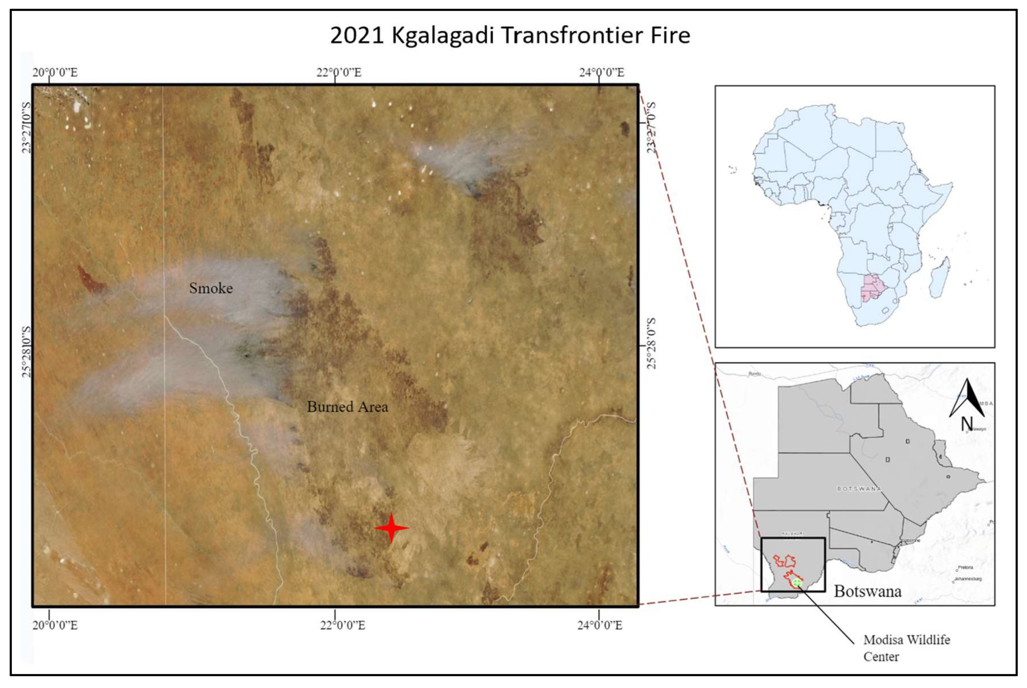
Figure 2.
The top left corner depicts the 1 sq. km post-burn plot of land that this study primarily focused on. The bottom panel in the figure offers a closer look at the burn impacts within the plot of land. The top right corner displays the location of the study site in Botswana, Modisa is indicated with a red star.
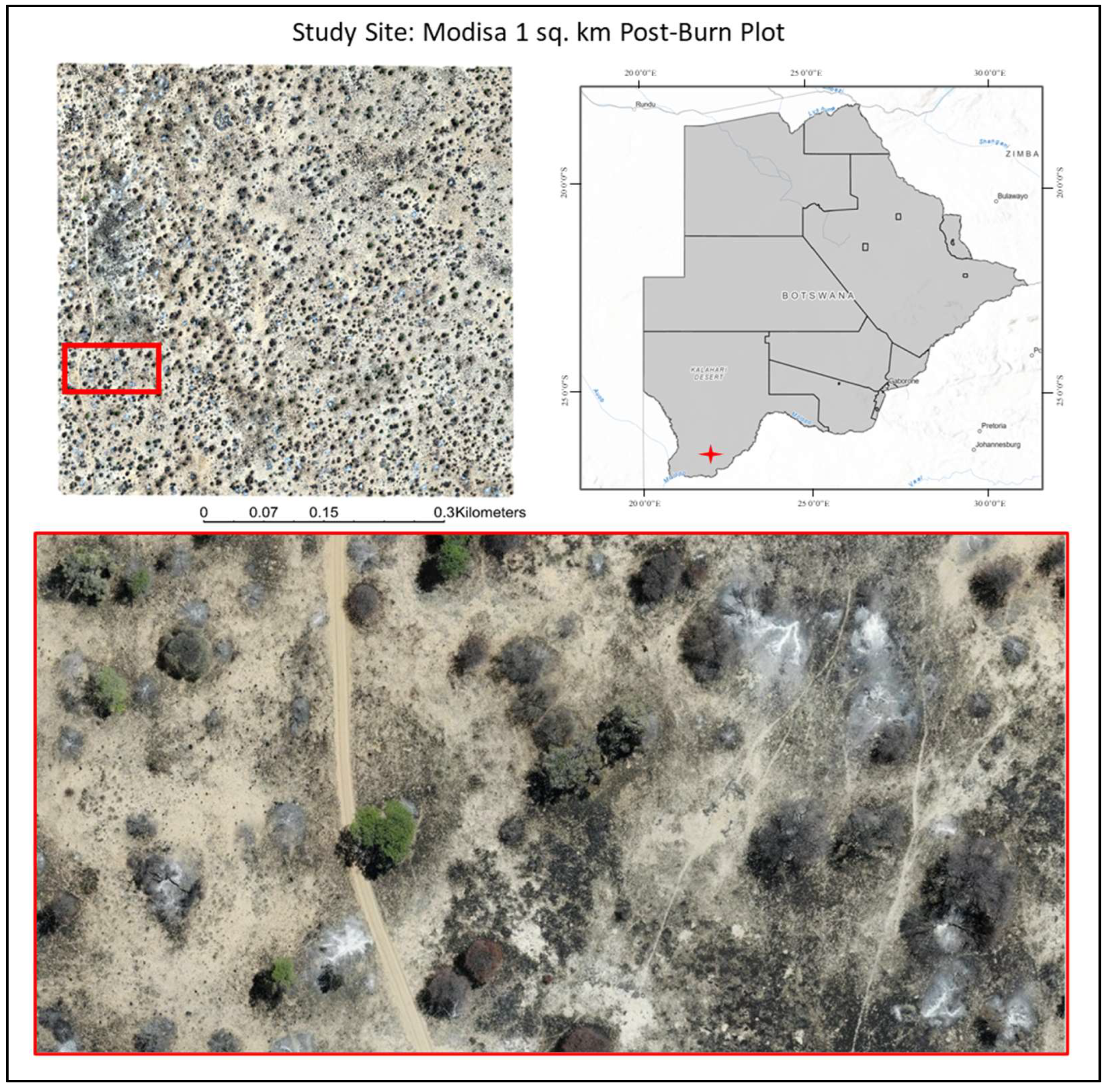
Figure 3.
Flow chart showing the steps of the burn severity classification model along with the datasets and software used. R: red; G: green; B: blue; GLCM: Gray-Level Co-Occurrence Matrix; UAS: Unmanned Aerial System.
Figure 3.
Flow chart showing the steps of the burn severity classification model along with the datasets and software used. R: red; G: green; B: blue; GLCM: Gray-Level Co-Occurrence Matrix; UAS: Unmanned Aerial System.
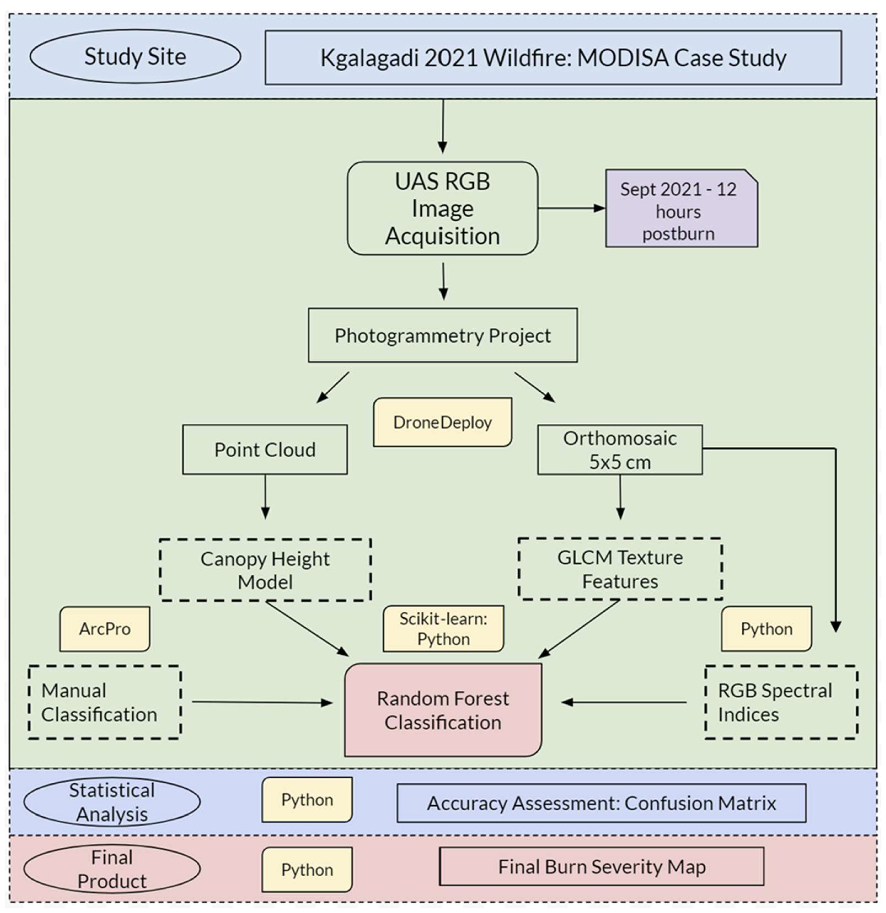
Figure 4.
Visualizations of land cover classification schema and their corresponding burn severity rankings.
Figure 4.
Visualizations of land cover classification schema and their corresponding burn severity rankings.
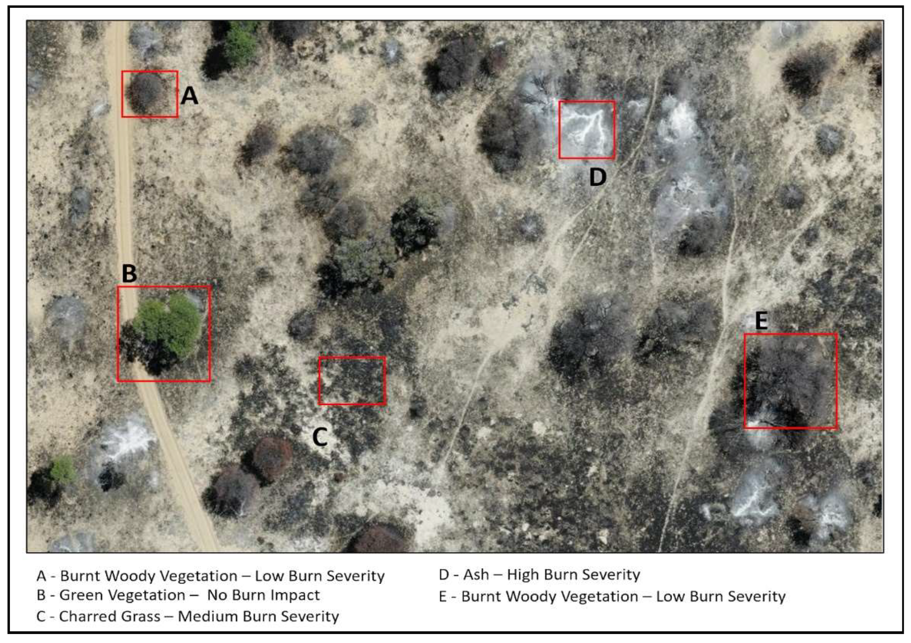
Figure 6.
Visual comparison of 12-hour post-burn imagery and 6-month post-burn imagery. Woody vegetation regrowth visualization is defined and compared to herbaceous cover as indicated with the red boxed outlines. Regrowth was determined based on patch regrowth rather than analysis at the pixel level.
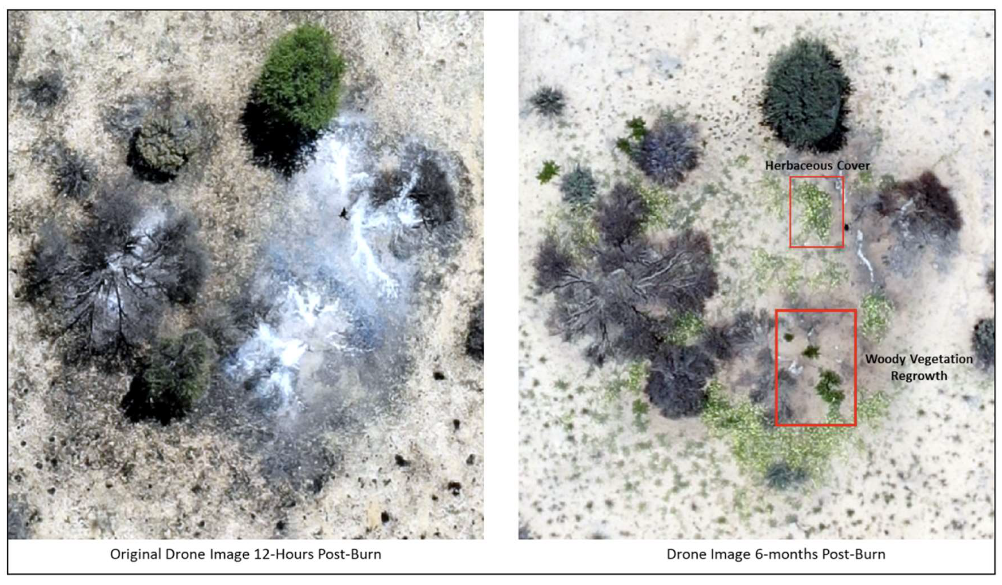
Figure 9.
Confusion Matrix for Random Forest Classification of Burn Severity. Each cell shows the proportion of observations predicted versus the actual observed categories, highlighting the model’s precision and misclassification rates. Numerical values and gradient color of the cells represent the normalized value of correct pixel predictions.
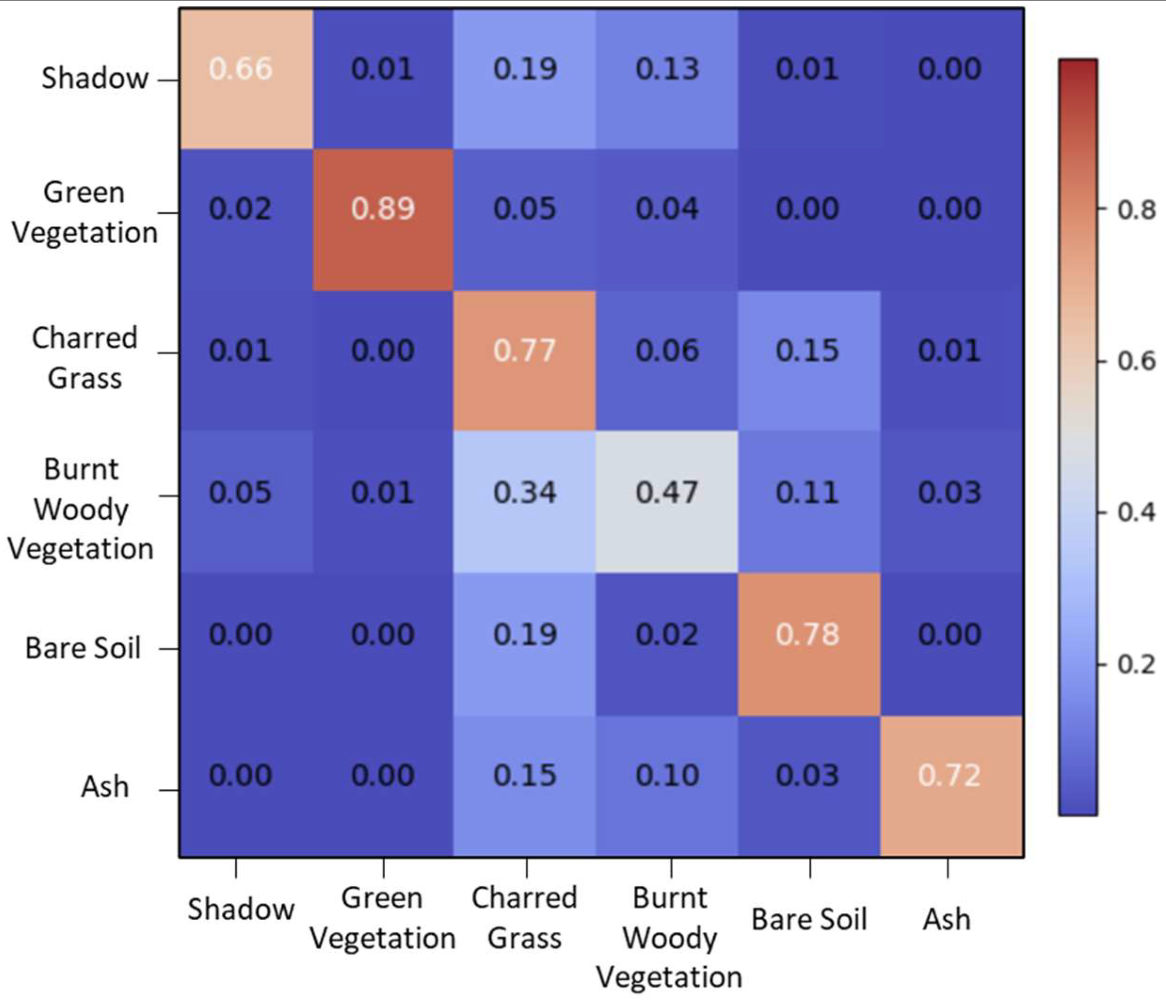
Figure 11.
Woody Vegetation Survival and Regrowth. This figure presents the probability of survival and regrowth in woody vegetation at 6 months and 2.5 years post-burn across the 1,000 derived Monte Carlo outputs. Mean probabilities and standard deviations are calculated for each category. Wider violin plots indicate a higher likelihood of regrowth, while narrower plots suggest a lower likelihood.
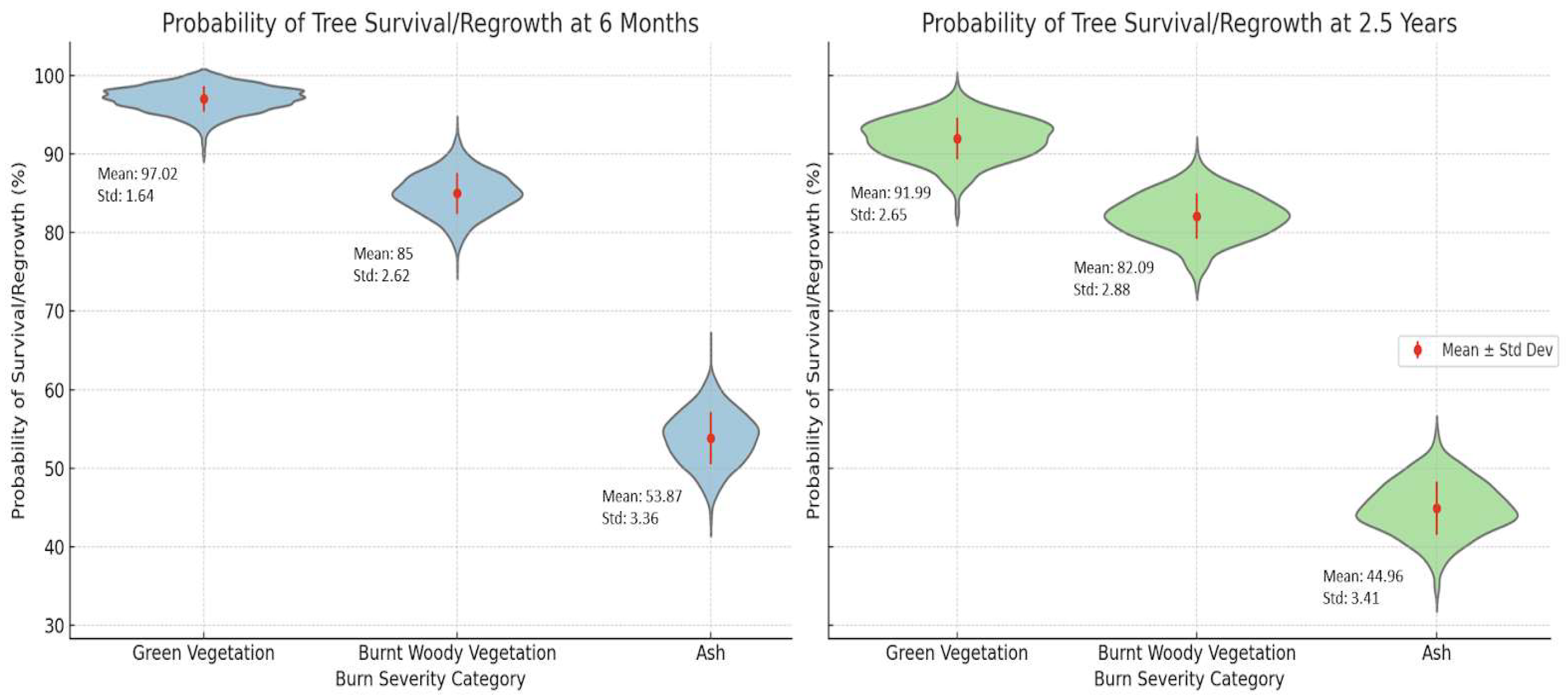
Figure 12.
Sample of RGB images used within the manual classification dataset and their corresponding CHM in meters. White spots within the CHM are indicative of taller vegetation.
Figure 12.
Sample of RGB images used within the manual classification dataset and their corresponding CHM in meters. White spots within the CHM are indicative of taller vegetation.
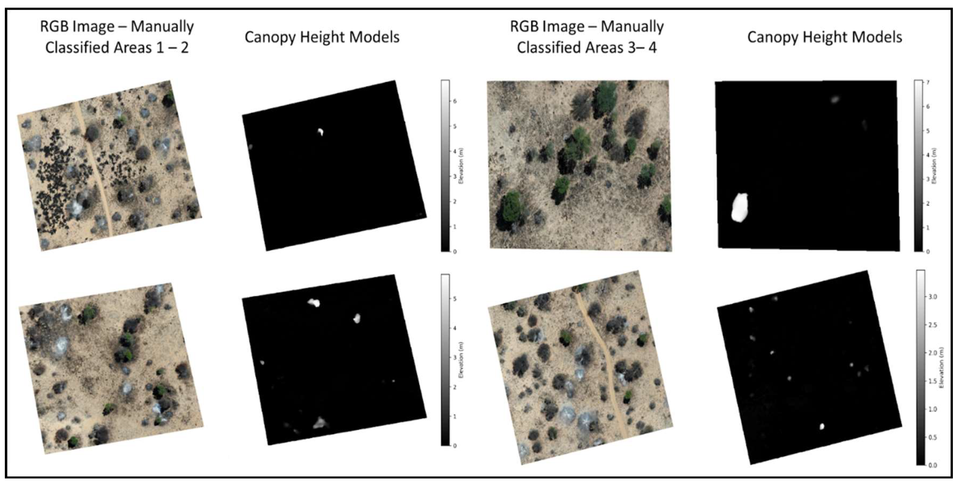

Table 1.
Dates of drone imagery acquisition and their respective season.
| Date of Image Acquisition | Time Since Fire |
|---|---|
| Sept 26th, 2021 – Dry Season | 12-hours post-burn |
| December 29th, 2021 – Wet Season | 6 months post-burn |
| July 21st, 2022 – Dry Season | 1-year post-burn |
| August 9th, 2023 – Dry Season | 2 years post-burn |
| November 23, 2023 – Wet Season | 2.5 years post-burn |
Table 2.
Land cover classifications and their corresponding burn severity ranking.
| Classification Schema | Burn Severity Ranking |
|---|---|
| Green Vegetation | 0 – No Burn Impact |
| Bare Soil | 0 – No Burn Impact |
| Burnt Woody Vegetation | 1 – Low Severity |
| Charred Grass | 2 – Medium Severity |
| Ash | 3 – High Severity |
| Shadow | Null |
Table 3.
Variables used to train the model. Where: G = Green, R = Red, B = Blue, DSM = Digital Terrain Model, DSM = Digital Surface Model, GLCM = Grey Level Co-occurrence Matrix.
Table 3.
Variables used to train the model. Where: G = Green, R = Red, B = Blue, DSM = Digital Terrain Model, DSM = Digital Surface Model, GLCM = Grey Level Co-occurrence Matrix.
| Training Indices & Variables | Equations & Descriptions |
|---|---|
| Excess Green Index (EGI) | 2 × G − R – B |
| Green Chromatic Coordinate Index (GCC) | G/(G + R + B) |
| Char Index (CI) | BI + (MaxDiff × 15) |
| Brightness Index (BI) | R + G + B |
| Maximum RGB Difference (MaxDiff) | Max(|B − G|, |B − R|, |R − G|) |
| Red Band | R |
| Green Band | G |
| Blue Band | B |
| CHM | DSM - DTM |
| GLCM - Contrast | Measures the local variations in GLCM. |
| GLCM - Energy | Provides the sum of squared elements in the GLCM. |
| GLCM – Correlation | Measures the joint probability occurrence of the specified pixel pairs. |
| GLCM – Homogeneity | Measures the closeness of the distribution of elements in the GLCM to the GLCM diagonal. |
Table 4.
Model accuracy assessment.
| Land Cover Classification | Precision | Recall | F1-Score | Support |
|---|---|---|---|---|
| Shadow | 0.73 | 0.66 | 0.70 | 335703 |
| Green Vegetation | 0.90 | 0.89 | 0.90 | 210213 |
| Charred Grass | 0.74 | 0.77 | 0.75 | 3019852 |
| Burnt Woody Vegetation | 0.55 | 0.47 | 0.51 | 771185 |
| Bare Soil | 0.77 | 0.78 | 0.78 | 2285950 |
| Ash | 0.76 | 0.72 | 0.74 | 223648 |
| Weighted Average | 0.74 | 0.74 | 0.73 | |
| Overall Accuracy (OA): 0.795970 |
Disclaimer/Publisher’s Note: The statements, opinions and data contained in all publications are solely those of the individual author(s) and contributor(s) and not of MDPI and/or the editor(s). MDPI and/or the editor(s) disclaim responsibility for any injury to people or property resulting from any ideas, methods, instructions or products referred to in the content. |
© 2024 by the authors. Licensee MDPI, Basel, Switzerland. This article is an open access article distributed under the terms and conditions of the Creative Commons Attribution (CC BY) license (http://creativecommons.org/licenses/by/4.0/).
Copyright: This open access article is published under a Creative Commons CC BY 4.0 license, which permit the free download, distribution, and reuse, provided that the author and preprint are cited in any reuse.


