Preprint
Article

An Assessing the Role of Watershed Management Practices in Gullele Botanical Garden, Addis Ababa, Ethiopia

Altmetrics

Downloads

81

Views

38

Comments

0

This version is not peer-reviewed

Submitted:

27 August 2024

Posted:

29 August 2024

You are already at the latest version

Alerts
Abstract
Ethiopia is a country that is in the process of development. Unfortunately, the management and utilization of watershed resources in this region are inadequate. This has resulted in a decrease in the quality of essential resources like soil, water, plants, and animals. Our research delved into the intricate biophysical conditions, conservation practices, and key issues surrounding watersheds along with their root causes and current strategies. The study was particularly focused on understanding the reality and different approaches employed in watershed management practices at the Gullele Botanical Garden located in Addis Ababa. We gathered information through interviews with experts and technicians, direct on-site observations, and official records from the garden's administration office. The gathered data was meticulously analyzed both qualitatively and quantitatively using Arc Map 10.3 to gain a comprehensive understanding of the area. Our findings revealed that the main objective of watershed management in areas surrounding restricted forest sites, Dam A, and Dam B was centered on conserving soil and water resources. The study emphasized the importance of selecting appropriate technologies for effective water and soil conservation practices. Data collection was done using purposive and random sampling methods, drawing information from a variety of sources such as the Gullele Botanical Garden office, literature, research reports, student theses, and both published and unpublished organizational documents. Despite these efforts, our study highlighted inefficiencies in the institutions responsible for watershed management. In particular, the maintenance of stone bunds, gullies, and gabions was not conducted adequately, leading to project deficits. Moving forward, we recommend raising awareness, enhancing training programs, and strengthening law enforcement and watershed policies to transform the knowledge, skills, and attitudes of technicians and staff involved in watershed management techniques for the better.
Keywords: 
Subject: Biology and Life Sciences  -   Biology and Biotechnology

INTRODUCTION

1.1. Background of the Study

A watershed refers to a geographical area consisting of land and water that contributes to a single location. It can be viewed as a complex system that encompasses physical, social, economic, and biological elements. In recent times, a new approach to the management of land, water, and biomass resources has gained popularity, known as watershed management. This approach emphasizes social and environmental factors and involves a participatory approach (Kerala, 2004).
The management of watersheds is essential for ecological stability, economic prosperity, and human well-being, as it ensures the availability of freshwater supplies that support the health of aquatic and terrestrial ecosystems, which in turn provide ecosystem services to benefit humans.(Falkenmark & Rockström, 2013).
Freshwater is equally important to both human society's survival and economic development. The freshwater cycle connects ecosystems and human society as a part of the larger hydrological cycle. The majority of water used by humans is typically accounted for by the five primary sectors.(Programme & UN-Water, 2012). Water is essential for various purposes like drinking, household uses, cooking, cleaning, and hygiene. It is also crucial for energy, industries, human settlements, food, and agriculture (primarily irrigation). Water is necessary for certain aspects of sanitation and ecosystems (both aquatic and terrestrial), as it sustains or restores the benefits to people (ecosystem services). All these watershed uses are valuable for human happiness, but they compete with each other for freshwater resources. The main reasons behind water crises in many regions of the world are competition, uneven distribution of water resources across space and time, and the impact of human activities on that distribution. (IFPRI, 2005).
According to IFPRI, the effects of climate change are exacerbating the complex water cycle in watersheds. Specifically, the rise in extreme weather events, such as droughts and heavy rainfall, is adding extra pressure on water supplies due to poor watershed management. More and more people are becoming concerned about issues such as flooding in farmed, urban, and industrial areas, overuse of groundwater aquifers, salinization and waterlogging, pollution from industrial and urban waste, and contamination from pesticides and fertilizers used on agricultural land. Many of these problems are closely tied to changes in land use (IFPRI, 2005).
Studies have shown that watershed security refers to maintaining an acceptable level of water-related risks for people, the environment, and economies while ensuring an adequate supply and quality of water for human health, livelihoods, ecosystems, and productivity. This includes preserving access to water for both people and the environment, preventing water-related disasters such as floods and droughts, and making sustainable use of water resources and infrastructure (IFPRI, 2005).
The economy and resources of emerging nations are largely determined by the productivity of their agricultural sector. This productivity, in turn, depends on the management and conservation of natural resources within watersheds. Unfortunately, in many emerging countries, the quantity and quality of these natural resources are declining rapidly, which has led to an increase in catastrophic floods and droughts (Fikru, 2009).
Land degradation in developing nations is caused by population pressure, small farm sizes, unstable land tenure, land redistribution, restricted access to credit, inadequate education, inappropriate and unsustainable land use, and poor watershed management (IFPRI, 2005). Ethiopia, like many other developing countries, is struggling with a shortage of land resources, which is leading to poor use and management of natural resources such as plants, animals, water, and soil. Ethiopian farmers are facing various challenges related to land degradation, such as soil erosion, sedimentation, nutrient depletion, deforestation, and overgrazing. These issues are hindering their ability to enhance agricultural output and reduce poverty and food insecurity (Temesgen, 2012). Not much is known about the lack of research on natural resources and watershed management, including the correlation between biodiversity and watershed management. In Ethiopia, significant measures for watershed management were taken during the 1970s to tackle the issues of soil erosion and land degradation. Since then, millions of trees have been planted, and extensive terraces and bunds have been constructed to address the problem (Yeraswork, 2000). Despite various watershed management approaches to combat land degradation, the adoption rate of these practices has fallen short of expectations. A watershed management approach aims to better manage natural resources for sustainable use, conservation, and livelihood enhancement (Bekele, 2007).
Gullele Botanical Garden is situated in the Entoto mountain range, which has been mostly covered in Eucalyptus globules since the early 19th century. The terrain of Mount Entoto is mostly undulating, with steep slopes that are particularly affected by heavy rainfall that can cause soil erosion. In gardens, two approaches have been employed since their inception to conserve soil and water: biological and physical (Talemos et al., 2021). However, Gullele Botanical Garden has not conducted any additional study on watershed control techniques. As a result, this research contributed to the evaluation of watershed management techniques and the creation of suggestions for future watershed development and management.

3. Material and Methods

3.1. Site Descriptions

The Gullele Botanic Garden is situated 4.3km northwest of the center of Addis Ababa, the capital city of Ethiopia. Its coordinates lie between latitudes 8o 55' N and 9o05' N, and longitudes 38o05' E and 39o05' E (Figure 1). The garden is bordered by the Oromia Regional State to the north, and Addis Ababa, Gullele, and Kolfe Keranyo sub-City to the south. It is situated in the central plateau and dry evergreen agro-climatic zones of Ethiopia and has two distinct topographic landscape units: the northern half is flat land, while the southern half is mountainous, with a maximum elevation of 3000m above mean sea level. Two perennial watercourses originate from this mountainous area and flow southwards towards the city center. The Gullele Botanic Garden is renowned for its collection of several Ethiopian endemic and indigenous plant species that face extinction and require protection. The garden is home to riverine vegetation and remnants of indigenous trees of the city of Addis Ababa. Its purpose is to collect living plants from the whole country to rescue threatened flora from extinction through enhancing biodiversity conservation, research, education, and aesthetic values. Furthermore, the garden aims to develop as a national and international standard representative of Ethiopian endemic and indigenous plants, and offer scientists an array of rich plant collections to research diverse species interaction, and ecological dynamics. It also provides an inspirational place for enjoyment and learning. In addition, the garden was intended to intensify indigenous knowledge of biodiversity conservation, climate change mitigation, and urban greening options.
At Gullele Botanic Garden, a total of 1200 plant species were collected, out of which 166 have medicinal properties. Among these, 65 plant species are exclusively found in Ethiopia and Eritrea. These unique species include 16 herbs, 37 shrubs, 22 trees, 4 shrubs/trees, 1 herb/shrub, and 1 climber. Additionally, there are 11 large mammal species and 95 bird species present in the garden. One of the animal species and one of the bird species are endemic to Ethiopia (Fikedu, 2021).

3.2. Sampling Methods

In this study area, researchers used purposive and random sampling techniques. The first step was purposive selections of watershed areas namely Dam A and Dam B reserved forest sites. The second step was the simple random sampling of the area from the GBG. To facilitate this final stage, the lists of names of a specific area in each selected area were selected by the researcher and the field extension officers of Gullele Botanical Garden.
The total number of stakeholders found in Gullele Botanical Garden participating in watersheds is 400. The sample size for this study was 44 stakeholders using the Cochran formula as below. The number of sample stakeholders for the interview was determined using the formula developed by Cochran (1977).
n’= z2pq/d2
n=n’/1+n’-1/N
Where n’= desired sample size when the population is greater than 10,000 n= no. of sample sizes when the population is less than 10,000 Z= 95% confidence limit (z-value at 0.05 is1.96) p=0.05(proportion of the population to be included in the sample i.e. 5%) q=1-0.05 i.e. (0.95), = total number of population (400) and d=margin of error or degree of accuracy (0.07). The stakeholders in the study area are less than 10,000 in number; both equations (1 and 2) were used to determine the sample size required in this study as follows: n’=z2pq/d2= (1.96) *(0.05) *(0.95)/ (0.07)2= 37.24 then n=n’/1+n’-1/N=37/ (1+(37-1)/400=33 therefore, the sample size required (n) in the study area was 33 stakeholders, since some stakeholders are less than 10,000 in number, but, 37 stakeholders were used for precision. Donald (1967) recommends taking a random sample of 10-20% of non-respondents to use in a non-respondent follow-up analysis, therefore 20%of 37 which is 7.4 was added as a contingency. Therefore, the sample size used (n’) in this study was 37+7=44 stakeholders.

3.3. Methods of Data Collection

Structured interviews were conducted to collect primary data, using a structured questionnaire that was administered to soil conservation experts in the watershed. Focus group discussions and key informant interviews with soil and water conservation leaders were also conducted to obtain additional information. Arc Map 10.3 was utilized to analyze the topographic features of the watersheds, such as slopes and stream networks, at Gullele Botanical Garden. Data collection for this study was conducted at both the household and plot levels through interviews and field observations. To gather information at the household level, a structured questionnaire was used to interview the household head. The questionnaire covered background information, household characteristics (such as sex, age, educational status, etc.), watershed problems and root causes, and information related to watershed management (such as conservation activities). At the plot level, field observation was carried out to collect relevant data on watershed characteristics and their management.
During the field observation, we examined the physical resources and conservation measures within the watershed. We focused on the stone bunds and cut-off drains used for soil and water conservation and compared them with standard applicability parameters. Additionally, we gathered secondary data from various sources including the Gullele Botanical Garden office data, books, study reports, student theses, as well as published and unpublished documents of organizations.

3.4. Data Analysis

For this particular study, the researchers used both quantitative and qualitative data analyzing methods. In this case of quantitative data analyzing methods, the primary data collected from the household survey were present in figures, tables, and percentages. In the case of qualitative data analysis, the collected primary data was checked, arranged, processed, and analyzed in a Word spreadsheet. Study area data were analyzed by using Arc Map 10.3.

4. Result and Discussion

4.1. Soil and Water Conservation Analysis

The terrain of Mount Entoto is mostly undulating, with steep slopes that are highly susceptible to soil erosion caused by heavy rainfall. Two primary approaches have been utilized to implement soil and water conservation measures in the garden. The first approach involves planting grasses to control erosion biologically. The second approach involves constructing structures such as stone, wood, and soil terraces, gabion check dams, ditches for water infiltration, canals to divert runoff, cutoff drains, and wire mesh (Seta & Telake, 2021).
Table 2. Soil and water conservation analysis in the study area.
Activity Unit Quantity
Soil erosion protection (cutoff drains, hillside terraces, stone-faced soil bands) 4854
Wire mesh/Gabion check dams 1250
Stone and wood check dams 2700
Deep trench and retaining wall 5130
Micro basin/half moon 1210
Swamp area development No. 5
Biological method (planting grass and trees) m 4700
Table 3. The respondents of educational status in the study area.
Name of watershed Non-educated Diploma Degree
BA MSC PHD
NO. % NO. % NO. %
No. % No. %
DAM A 0 0 0 0 2 10 40 80 2 10
DAM B
total 100
Table 4. Respondents' age description in the study area.
Respondent age No. of respondent Percent %
25-30 2 5
>30 42 95
Total 100

4.2. The Key Watershed Problems and the Root Causes

4.2.1. Dam A Watershed
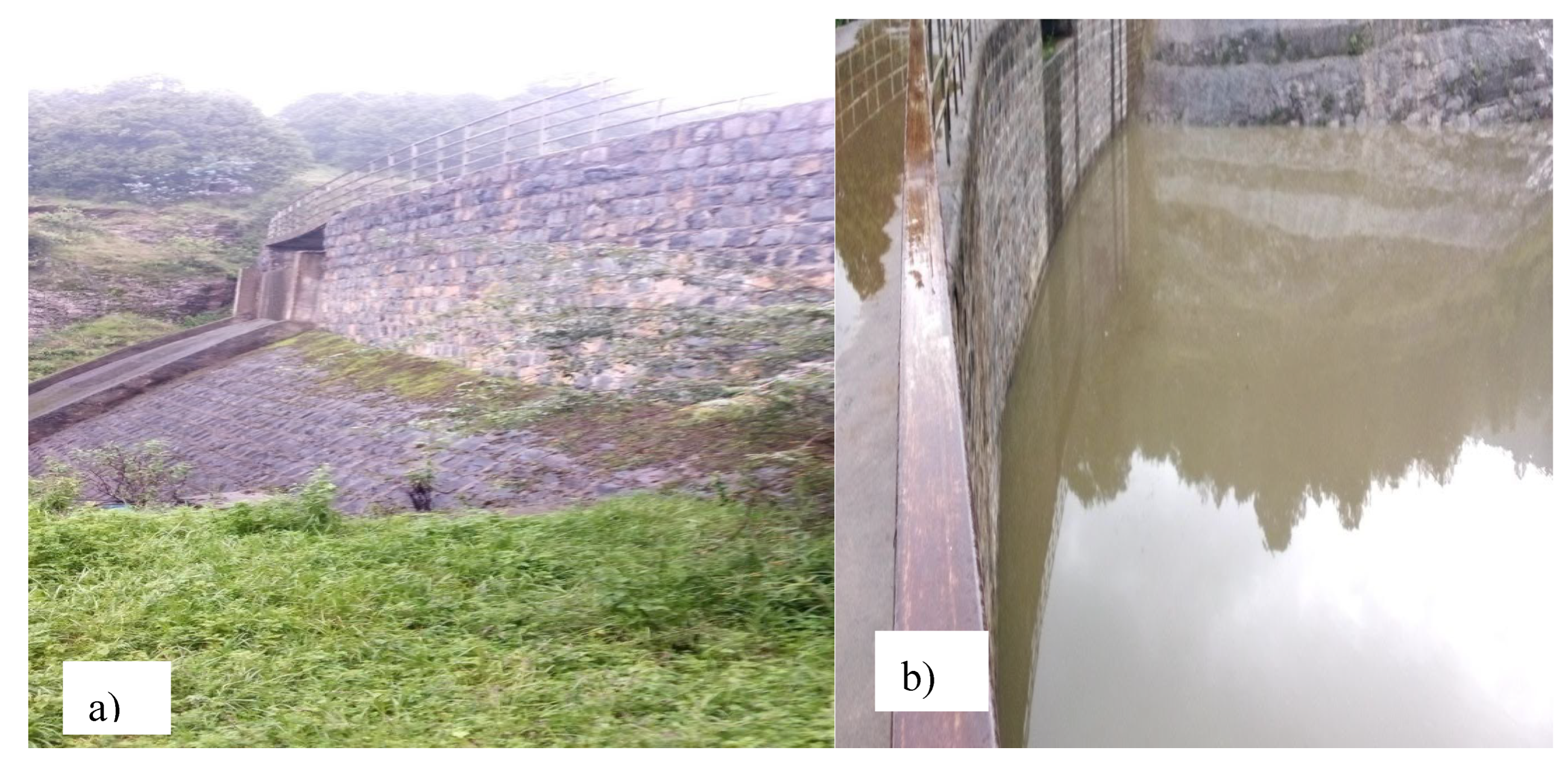
During the field assessment and observation period, it was noted that the Dam A watershed has aged. According to the locals, 13 years ago, Gullele Botanical Garden was under the administration of Addis Ababa Environmental Protection. During that time, the entire land was covered by Eucalyptus globules, and no conservation activities were carried out in this watershed. In the past, this area was known by a different name, but it was later changed to Gullele Botanical Garden, which was founded by Addis Ababa University and the Addis Ababa City Administration. After the Garden was established, some stone bunds and dams were built in the area, with the area of Dam A being covered by rocks. During the field assessment and observation period, it was observed that the upper part (top slope) of this watershed was partially covered by some grasses and trees. However, this large watershed is not currently functional.
Figure 5. a) Upper part and b) inner part of Dam A respectively. Source; Horticulture and Conservation Department, Gullele Botanical Garden, 2023.
Preprints 116445 g002
Managing a watershed involves managing plots of land and shared resources such as forests, springs, gullies, roads, and footpaths (Swaran, 2001). During the field assessment in Dam A watershed, a severe problem of soil erosion caused by water was observed in the cultivation land and around the road. Sedimentation, or deposition of soil, was also observed in the corner of the plant area. The main types of erosion observed were gully and rill erosion. As a result of these erosions, the area experienced loss of fertile topsoil, nutrients, soil depth, and fertile land. Additionally, some parts around the road corner were destroyed due to erosion.

4.2.1.1. Cause of Problem in Dam A

The Gullele Botanical Garden personnel and tourists do not intentionally damage it. However, various socio-economic, institutional, and political factors can limit land management choices and lead to mismanagement. (Abbay Basin Master Plan, 1999). In this survey, various types of mismanagement that caused soil erosion were investigated.
Table 6. Cause of soil erosion in rank in DAM A.
Rank Cause of soil erosion Number of respondents Percent %
1 Mismanagement 20 40%
2 Land slope 10 25%
3 Lack of expert 6 20%
4 Excessive rainfall 5 10%
5 Lack of money 3 5%
Total 44 100
Source: Gullele Botanical Garden, 2023.
During the field assessment, it was discovered that there was a loss of physical structure construction and mismanagement within the boundary of Dam A. Respondents and field assessment indicated that the lack of watershed management, loss of nutrients, and the steep and sloppy nature of the land, due to mismanagement in the upper catchment of the watershed runoff coming from Entoto Mountains, was the root cause of watershed problems, specifically soil erosion in the area.

4.2.2. Dam B Watershed

In 2022, Ethiopian Prime Minister Dr. Abiy Ahmad initiated the national green legacy by planting a new forest in the Dam B watershed. This area was previously uncontrolled, leading to excessive runoff from the upstream part and causing severe soil erosion and degradation in unplanted land. The new plantation will help control the runoff and prevent further damage to the soil. Soil erosion leads to the loss of an organic buffer layer, resulting in exposure to aluminum toxicity and acidification, which causes a sudden and significant reduction in yields (FAO, 1999).
Soil erosion involves the loss of fine particles, nutrients, and organic matter and contributes to the loss of structural stability of soil, surface compaction and sealing, reduced water infiltration, and increased surface runoff (FAO, 2000). Land degradation has resulted in low soil nutrient levels in the study area, which has prompted measures to reduce it. This has led to an increased demand for soil and water conservation technologies, as well as daily workers for land preparation and weeding. The watershed has been observed to have shallow soil depth, eroded topsoil, exposed permanent matter, and other related issues.

4.2.2.1 Cause of the Problem in the Dam B

Based on feedback from survey participants, it was found that the Gullele Botanical Garden technician and expert, along with field assessment, identified several key factors contributing to watershed problems in the area. These included the absence of proper treatment for watershed management, soil loss, the steep and sloppy nature of the land, and the lack of upper catchment of the watershed treatment.
Table 7. Cause of soil erosion in rank in Dam B.
Rank Cause of soil erosion Number of respondents Percent %
1 Mismanagement 20 40%
2 Land slope 10 25%
3 Lack of expert 6 20%
4 Excessive rainfall 5 10%
5 Lack of money 3 5%
Total 44 100
Source: Gullele Botanical Garden, 2023.

4.3. Biophysical Factor

4.3.1. Slope Classification

The Horticulture and Conservation Department of Gullele Botanical Garden has developed a classification system for constructing Soil and Water Conservation technology. Based on the slopes, plots are classified into different categories such as Flat (0.2%), Gentle sloping (3-6%), Moderately steep sloping (6-15%), Steep slopes (15-30%), and Very steep slopes and mountains (>30%). These different types of plots require specific soil and water conservation measures to reduce soil erosion. For this study, four samples were taken from upstream and downstream of both watersheds to verify the Horticulture and Conservation Department's earlier classification. After classification and field observation, it was found that the upstream and downstream of Dam A are very steep slopes or mountain and flat, respectively. Similarly, Dam B is moderate and flat.

4.4. Analysis of Watershed Management (Conservation) Practices

Watershed management practices in rainfed regions are legally oriented towards rehabilitating degraded lands, protecting soil, water, and other natural resources for producing food, forage, fiber, and other products, and enhancing the flow of high-quality water from upland watersheds to downstream areas of consumption (FAO, 1986; Khan, 2002). Watershed management involves the sustainable use of soil and water resources within a specific geographical area to reduce the risk of floods and enable long-term production.

4.4.1. Soil and Water Conservation Practices
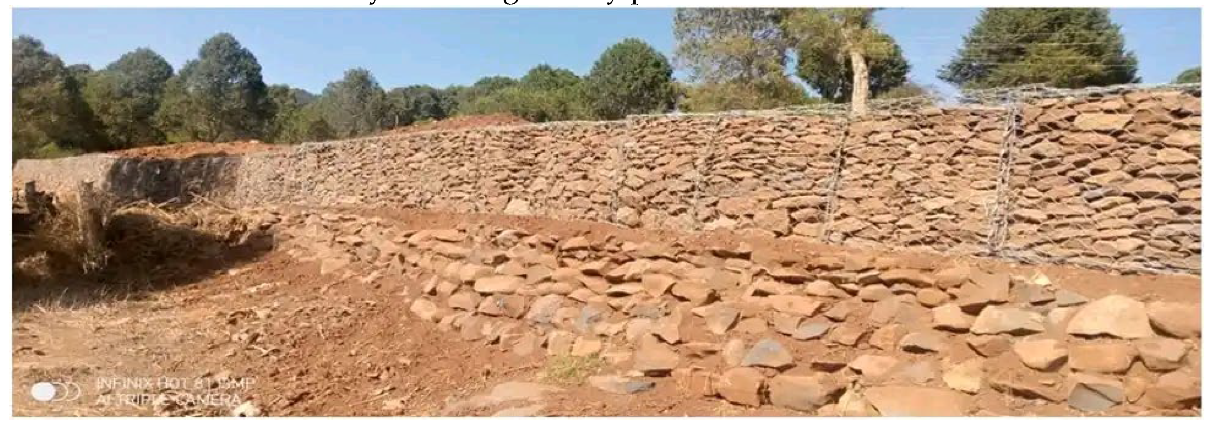
The study areas employ two types of soil and water management and conservation measures. These include soil bunds, traditional ditches, fanny juu, cutoff drains, and stone bunds (when there is excess stone and high runoff). In addition, newly introduced soil and water conservation technologies such as area closure have been implemented. Other common soil and water conservation practices, such as soil burning, mulching, compost manure, and green manure, are also culturally and indigenously practiced in both watersheds.
Figure 9. Water and soil conservation practices. Source: Gullele Botanical Garden, 2023.
Preprints 116445 g003
In these areas, the technician only partially uses soil bunds along contours, indicating a lack of sufficient soil bunds with standard parameters to control soil erosion.

4.4.2. Traditional and Newly Introduced Soil and Soil Water Conservation Practices

In order to prevent land degradation, particularly soil erosion, experts in both sub-watersheds utilize a combination of traditional and new soil and water conservation technologies. These technologies include the application of manure, traditional and newly introduced cut-off drains, and the planting of both traditional and newly introduced trees as well as stone bunds. During the survey, the expert asked which traditional soil and water conservation structures were being employed. The respondents reported the use of traditional stone bunds, traditional ditches, cut-off drains, and the planting of some trees.

4.4.2.1. Cut-Off Drain

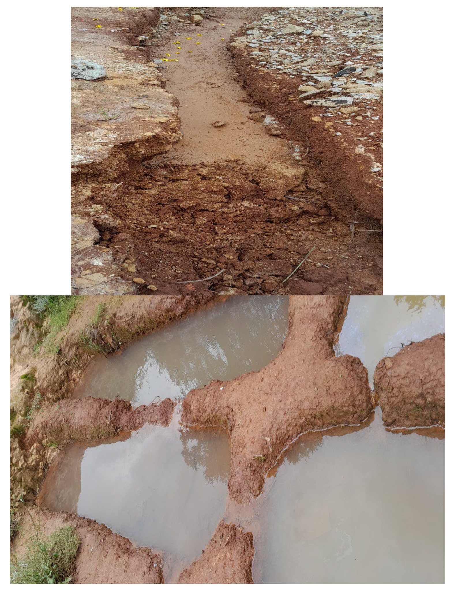
According to survey results, almost 25% of the sampled plots in both watersheds had traditional or improved cut-off drains. These drains are constructed by experts to prevent the loss of seeds, fertilizers, manure, and soil due to uphill water flow. This excess water is disposed of away from the field. However, some technicians believe that traditional drain structures may enhance soil erosion over time. As a result, experts in the study area are hesitant to install this type of soil and water conservation practices. During field assessment, it was observed that the size and gradient of the constructed cut-off drain in the upper part of Dam B watershed was not determined by the amount of run-off expected from the land above. Therefore, it couldn't protect cultivated land or downslope land from upslope runoff and erosion. Instead, it encouraged the formation of gullies in the direction it flows. Soil and water conservation technicians suggest that better surveying could improve the performance of the cut-off drains.
Figure 10. cut-off drain the wrong size and destroyed. Source; Horticulture and Conservation Department, Gullele Botanical Garden, 2023.
Preprints 116445 g004

4.4.2.3. Stone Bunds

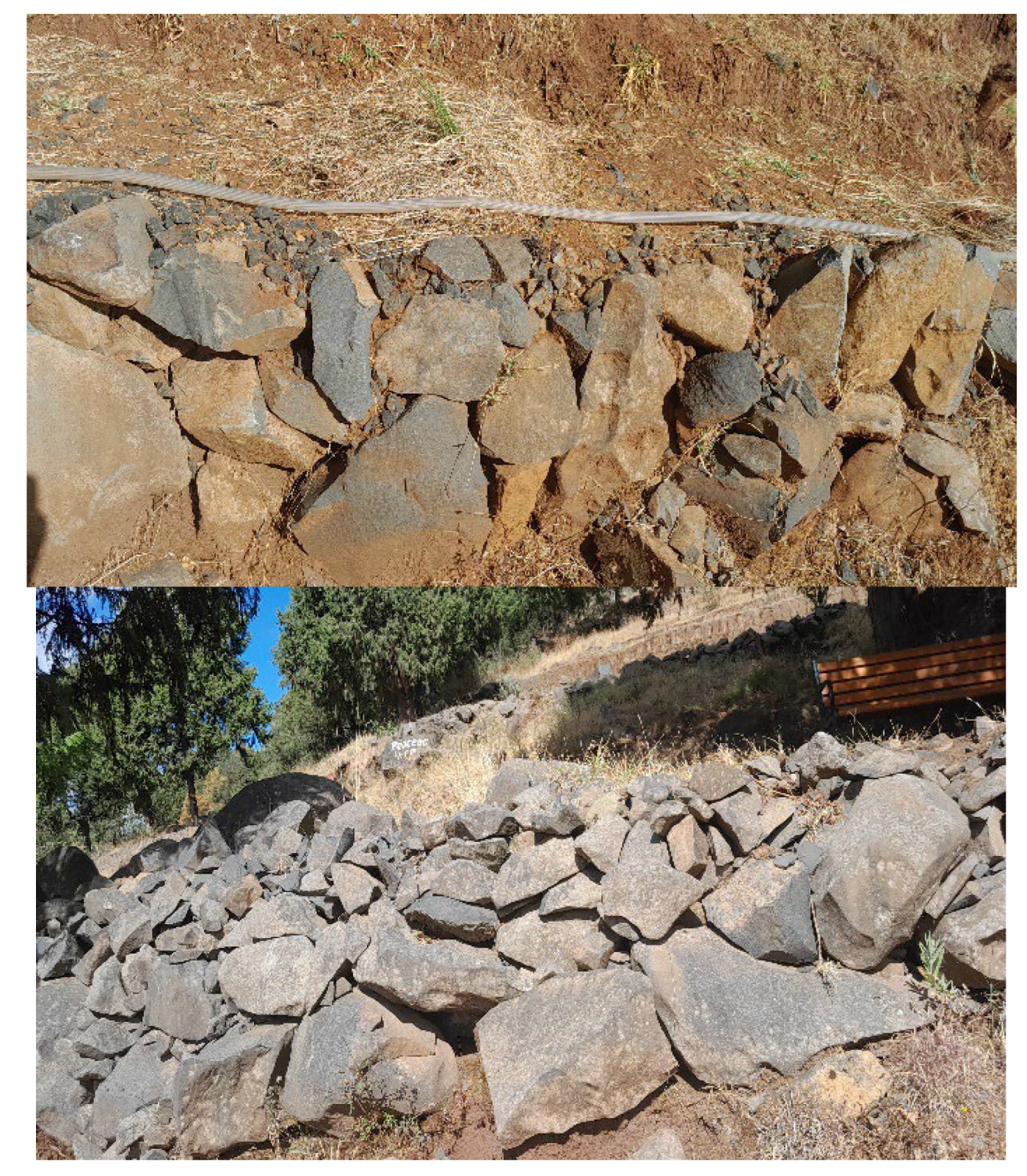
During the transect walks in the area, we observed traditional physical soil and water conservation practices, such as the construction of stone bunds. However, we also noticed that some of the stone bunds failed to serve their intended purpose. We believe this is due to the use of incorrect size and shape of stones, incorrect grade of face, insufficient width, lack of foundation, and improper selection and placement of stones
Figure 11. incorrect size and shape of stone bunds. Source; Horticulture and Conservation Department, Gullele Botanical Garden, 2023.
Preprints 116445 g005

4.4.2.4. Soil Fertility and Management Practices

Soil fertility is decreasing every year due to soil erosion caused by lack of management and nutrient uptake by plants. (Getachew, 2005).
Technicians used various methods to maintain and enhance soil fertility, such as creating compost and mulching grass. During the interview, experts were asked whether they had experience in improving soil fertility through traditional or modern methods. They replied that almost 91.4% of respondents used practices like mulching and creating manure compost.
Figure 12. compost manure preparation onsite for enhance soil fertility and plant germination. Source; Horticulture and Conservation Department, Gullele Botanical Garden, 2023.
Preprints 116445 g006
All the households surveyed reported using manure compost to maintain the soil fertility of their plots. The survey also revealed that technicians apply compost manure on almost all of the plots they manage to improve soil fertility. The majority of plots located in these two watersheds have better management practices for the application of compost manure.
Table 13. Purpose of application of Compost manure.
Purpose of use of compost manure Number of respondents in both watershed Total Percent %
Dam A Dam B
Soil fertility 44 44 44 100
Fuel 0 0 0 0
Both soil fertility and fuel 0 0 0 0
No use any 0 0 0 0
Source: Gullele Botanical Garden, 2022.

4.4.3. Participation of Households in Soil and Water Conservation

4.4.3.1. Participation in Implementation
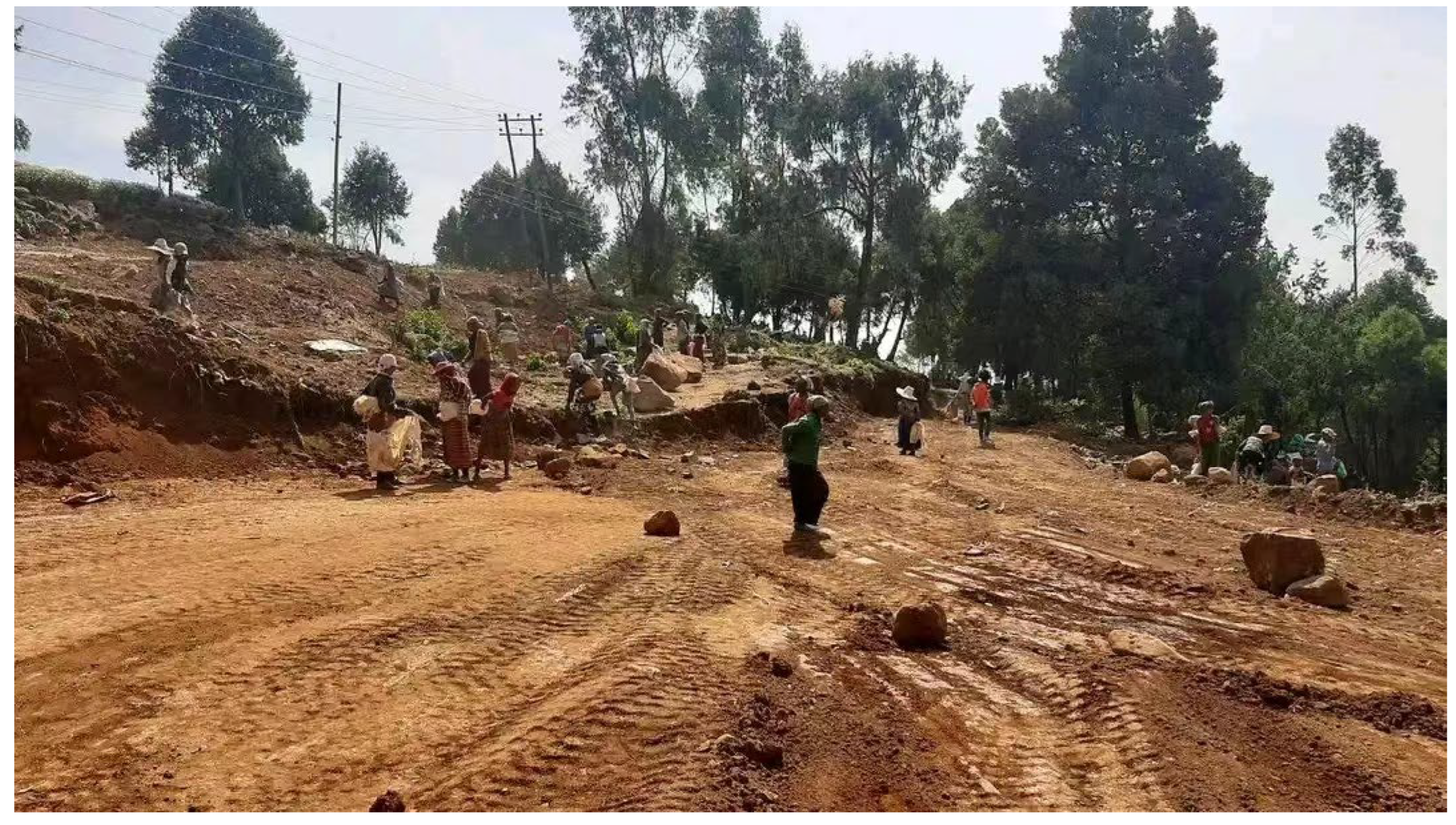
Local participation is crucial for watershed protection, according to the government and NGOs. (Pretty, and Ward, 2001). A survey was conducted to determine the involvement of local households as daily workers in soil and water conservation activities under the guidance of garden technicians. The Field Partners are responsible for designing the demonstration plot, as well as preparing, planting, and maintaining the land.
Figure 14. Participation in Soil and Water Conservation. Source: Gullele Botanical Garden, 2023.
Preprints 116445 g007
Field Partners made an excellent contribution throughout the planning phase. This is evident from the Field Partners' attendance at every focus group discussion during the planning phase and their familiarity with the state of the land. The community is aware that improper land management has increased soil erosion and decreased soil production. Furthermore, Field Partners' readiness to provide labor and manure is demonstrated by the community's involvement. The implementation of watershed plans will be the responsibility of several parties based on their interests, areas of competence, and authorities because watershed approaches are participatory. State and tribal water-related programmers must, to the greatest degree feasible, facilitate the execution of watershed plans through their actions. They ought to consider the whole array of instruments at their disposal in programmers as varied as safeguarding water quality, managing pesticides, managing waste, controlling air pollution, protecting natural resources, agriculture, water supply, transportation, and other associated programmers. For example, underwater quality and natural resource protection programs may:
  • ✓ Utilizing total maximum daily load assessments, support watershed approaches to nonpoint source pollution control, habitat preservation, water quality permits, and other water resource protection and restoration operations.
  • ✓ Target designated wellhead protection programmer protection areas and overall source water protection areas as a high priority for various federal and state programmers by using their watershed strategy.
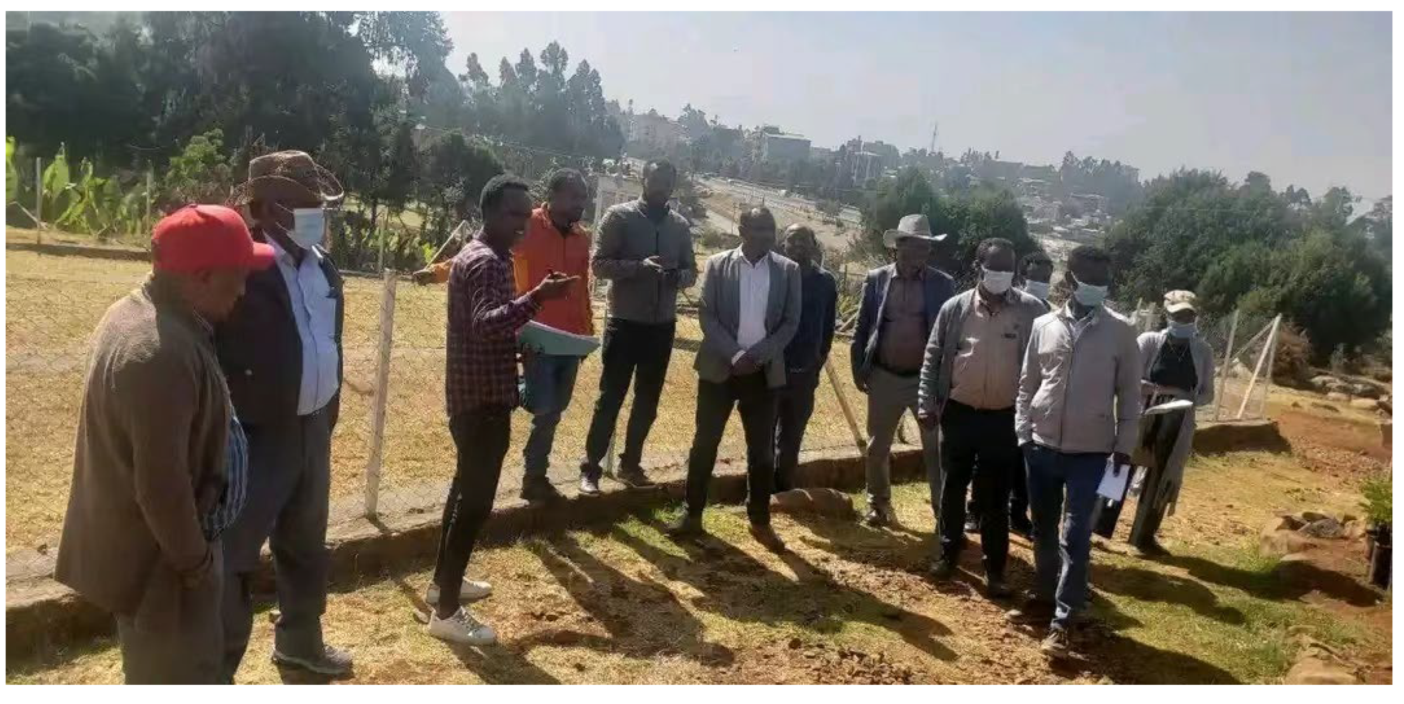
Figure 15. Field discussion with Horticulture and Soil Conservation Department Source: Gullele Botanical Garden, 2023.
Preprints 116445 g008
According to the Experts in the focus group discussion, they got experience from relative institutes when the soil and water conservation structures are constructed.

4.4.3.2 Participation in Maintenance
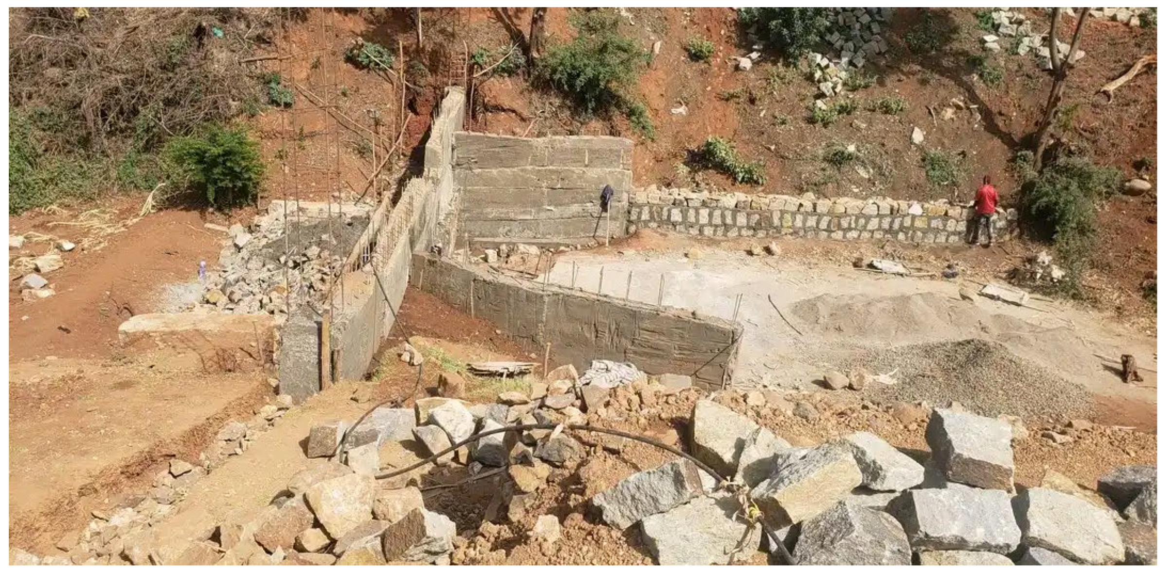
Experts and daily worker (labor) participation is essential not only for the implementation of soil and water conservation activities like stone bunding and gabion during planning of sustainable management of land and water resources.
Daily workers need more experience, and therefore experience is are issue that experts miss, and their objectives are more practical for economic development (Stocking, 1996). However, field observations showed that much of the soil conservation structures constructed in both watersheds were mostly partially. As respondents replied, when the constructed soil and water conservation structure were damaged by excessive runoff and mismanagement maintenance works were conducted.
Figure 16. Maintenance of mini dam. Source: Gullele Botanical Garden, 2023.
Preprints 116445 g009

4.4.3.3. Watershed Management Approach

Watershed management is an approach of area planning of natural resources to sub-serve the socio-economic needs of the human society or community concerned (Hinchcliffe et al., 1995).
A watershed management approach to land stewardship accommodates the interests of the widest possible number of people. The approach examines the benefits obtained from land stewardship by optimizing production and maintaining environmental integrity. It also facilitates ignoring effective conflict resolution from a sustainability perspective (Khan, 2002).
In a sample survey, the Horticulture and Conservation Department experts were asked about who prepared the watershed management plan and the type of watershed approach they used during implementation and decision-making. According to them when they prepare the watershed management plan there is participation and involvement of stakeholders in formulating, implementing, and decision-making process of the watershed management plan.
The result indicated the formulation, implementation, and decision-making process of watershed management practices partially considers the social, economic, and desired goals of the city of the area. They followed a top-down approach to watershed management practices.

4.5. Role of Watershed Management for Plants

The watershed is a significant portion of the biological diversity on Earth. They play a significant role in the world’s biological productivity and act as a significant reservoir. The sustainability of biotic communities depends on both water resources and their biodiversity, which are interconnected, valuable, and essential for a variety of tasks (UNEP, 2012).
Water biodiversity is continuously declining in both freshwater and marine environments as a result of the overuse of species, the introduction of exotic plants or animals, pollution from cities, industries, and agricultural areas, the loss and alteration of ecological niches, and pollution sources from these sources. The conservation and management of water biodiversity, including the establishment of bio reserve points, bioregional management, and global monitoring, are essential for its protection (Fikedu, 2021). The role of planting numerous endemic and indigenous plants at Gullele Botanical Garden is soil and water conservation.

5. Conclusions

A method focused on enhancing livelihoods and encouraging beneficial conservation, sustainable use, and management of natural resources, watershed management is a landscape-based approach. Numerous countries have pushed integrated watershed management as a viable tactic for raising agricultural production and sustaining agricultural intensification (Bekele, 2007).
In the Dam A and B sub-watershed, the integrated watershed management project proved unsuccessful. Given that integrated watershed management techniques include not only conserving soil and water but also considering the socioeconomic and cultural aspects of the local human population, comprehending animal life concerning feeding systems, and designing climate, soil texture, slope angle, and suggested future uses of certain constructions are all considered. For instance, gully erosion formed close to household and agricultural lands in the upstream portion of the Dam B sub-watershed due to improperly built stone bunds and cutoff drains. One of the causes is that the people who implemented the watershed neglected to address social concerns including how households should be approached and included in the decision-making process. The investigation of the two sub-watershed projects demonstrates unequivocally that the sustainability of the activities carried out by the watershed project is a prerequisite for the success of the watershed management project. Demand-driven, ownership-based, comprehensive integration, institutional, and income-generating (i.e., enhancing the standard of living of residents) techniques can all be used to guarantee the sustainability of activities. This can be accomplished by including research, development, and education within the watershed project.
The results of our research described Dam A and B watersheds focused only on soil and water conservation. Both watershed projects did not address issues like the establishment of a watershed management institution. They are also ineffective in gabion, gully and stone bunds practices and maintenance and the project was not followed effectively. Compost manure preparation for increasing soil fertility and plant germination was effective work. Therefore, the watershed management practices were not good in Dam A and Dam B.
Therefore, awareness creation for the technicians, development of watershed policy and enforcement of existing conservation measures, and coordination of stakeholders should be implemented by the government and it is better if the garden is considered as part of decision-makers for watershed management.

References

  1. Amhara National Regional State of the Federal Republic of Ethiopia (ANRSFRE) in collaboration with Global Environmental Facility (GEF) and International Fund for Agricultural Development (IFAD), (2008). Community-based integrated natural resource management in Lake Tana watershed, Ethiopia. Pp.28.
  2. Associated Programme on Flood Management (APFM) (2007) Formulating a basin flood management plan: A tool for integrated flood management.
  3. Ashby, J. (1996). What do we mean by participatory research in agriculture: participatory research and gender analysis for technology development, CIAT Publication No.294, Cali, Colombia.
  4. Bayley PB (1995) Understanding large river-floodplain ecosystems. Bioscience 45:153–158. [CrossRef]
  5. Bekele Tesemma, A. (2007). Profitable agro-forestry innovations for eastern Africa experience from agro-climatic zones of Ethiopia, India, Kenya Tanzania and Uganda. World Agro-forestry Centre (ICRF), Eastern Africa.
  6. Bruijnzeel LA (2004) Hydrological functions of tropical forests: not seeing the soil for the trees? Agri Ecosyst Environ 104:185–228. [CrossRef]
  7. Calder IR, Smyle J, Aylward B (2007) Debate over flood-proofing effects of planting forests. Nature 450:945. [CrossRef]
  8. Chambers R, Conway G (1991) Sustainable rural livelihoods: practical concepts for the 21st century. Institute for Development Studies (IDS) discussion paper no. 296.
  9. Chang L, Shen H, Wang Y, Huang J, Lin Y (2010) Clustering-based hybrid inundation model for forecasting flood inundation depths. J Hydrol 385:257–268. [CrossRef]
  10. European Commission (EC) (2007) Directive 2007/60/EC of the European Parliament and the council of 23 October 2007 on the assessment and management of flood risks. Off J Eur Union L 288:27–34.
  11. FAO. 1986. Watershed management in Asia and Pacific: Needs and Opportunities for Active Participation Study report-FAO: RAS/85/017, FAO, Rome, 166 pp.
  12. FAO, 2000. Rural Poverty, Risk and Development, by M. Faf champus, FAO economic and social development paper No. 144. Rome.
  13. Food and Agriculture Organization of the United Nations (FAO) (2006) The new generation of watershed management programmes and projects. FAO forestry paper 150. FAO, Rome.
  14. Food and Agriculture Organization of the United Nations (FAO) (2013) Forests and water. International momentum and action. Food and Agriculture Organization of the United Nations, Rome.
  15. Fikadu Erenso, 2021. Identification, characterization and valuation of eco-system services provided Gullele Botanical Garden, Addis Ababa, Ethiopia.
  16. Fikru Assefa, 2009. Assessment of adoption behavior of soil and water conservation practices in the Koga watershed, highlands of Ethiopia. A Thesis Presented to the Faculty of the Grad School of Cornell University Master of Professional Studies.
  17. Hinchcliffe F, I Guijt, JN Pretty and P Shah, 1995. New horizons: The economic, social and environmental impacts of participatory watershed development. IIED. Gatekeeper Series 50. pp 3-20.
  18. Inter-American Development Bank (IDB), 1995. Concepts and issues in watershed management, IDB, Washington, D. C.
  19. IFPRI (International Food Policy Research Institute), WUR (Wageningen University and Research Center) and EEPFE (Environmental Economics Policy Forum of Ethiopia),2005. Poverty and Land Degradation in Ethiopia: How to Reverse the Spiral?
  20. Jeffery, R. , Vira, B. 2001. Conflict and cooperation in participatory natural resource management, Palgrave, cited in: Dube, D., Swatuk, L. 2002. Stakeholder participation in the new water management approach: a case study of the Save catchment, Zimbabwe, Physics and Chemistry of the Earth, Vol. 27, 867-874.
  21. Johnston, J. 2001. Econometric Methods. Fourth edition, University of California, Irvine.496p.
  22. Johnson N, Ravnborg HM, Westermann O, Probst K (2002) User participation in watershed management and research. Water Policy 3:507–520.
  23. Johnson CL, Priest SJ (2008) Flood risk management in England: a changing landscape of risk responsibility? Int J Water Resour D 24:513–525. [CrossRef]
  24. Kahsay B, (2004) land use and land cover changes in the central highlands of Ethiopia: the case of Yerer Mountain and its surroundings a thesis submitted to the school of graduate studies, Addis Ababa University.
  25. Kerr, J. M., Sanghi, N. K., Sriramappa, G. 1996. Subsidies in watershed development projects in India: distortions and opportunities, Gatekeeper Series No. 61, International Institute for Environment and Development, London.
  26. Khan, M.A. 2002. Watershed Management for Sustainable Agriculture. Agrobios (India), Chopasni Road, Jodhpur, 237 pp, India.
  27. Khatibi R (2011) Evolutionary systemic modelling of practices on flood risk. J Hydrol 401:36–52. [CrossRef]
  28. MOARD 2005. Guide line for integrated watershed management, Addis Ababa, Ethiopia.
  29. Mostert E, Junier SJ (2009) The European flood risk directive: challenges for research. Hydrol Earth Syst Sci Discuss 6:4961–4988. [CrossRef]
  30. Pretty, J., Ward, H. 2001. Social capital and the environment, World Development, Vol.29, No.2, 209-227.Rhoades, R. E. 1998. Participatory watershed research and management: where the shadow falls, Gatekeeper Series No.81, International Institute for Environment and Development, London.
  31. Recha JW, Lehmann J, Walter MT, Pell A, Verchot L, Johnson M (2012) Stream discharge in tropical headwater catchments as a result of forest clearing and soil degradation. Earth Interact 16: Paper No. 13, 1–18.
  32. Rhoades, R. E. 1998. Participatory watershed research and management: where the shadow falls, Gatekeeper Series No.81, International Institute for Environment and Development, London.
  33. Roggeri H (ed) (1995) Tropical freshwater wetlands: a guide to current knowledge and sustainable management, Developments in hydrobiology (Netherlands) 112. Kluwer Academic Publishers, Dordrecht. ISBN 0-7923-3785-9.
  34. Sahlemedhin S. 1999. Ethiopia: Integrated Soil Management for Sustainable Agriculture and Food Security in Southern and East Africa. Proceedings of the expert consultation, 8-12 December, 1997, Harare, agritex, FAO, Rome, pp. 197-210.
  35. Stocking, M. 1996. Land management for sustainable development: farmer’s participation.
  36. In: Stocking, M., 2001. Handbook for the field assessment of land degradation, Eathscan, London.
  37. Talemos et al, 2021. Gullele Botanic Garden, Addis Ababa (Ethiopia): current status, challenges and opportunities.
  38. Temesgen Zewde 2012. Factors influencing land degradation in the Bilatte watershed: The case of Dimtu and Shelo sub-watersheds, Southern Ethiopia. A Thesis Submitted to School of graduate studies, Institute of Technology Department of Biosystem and Environmental Engineering. Hawassa University, Ethiopia.
  39. Tesfaye Habtamu 2011. Assessment of sustainable watershed management approach case study Lencha Dima, Tsegur Eyesus and Dijjil Watershed. A Project Paper Presented to the Faculty of the Graduate School of Cornell University in Partial Fulfillment of the Requirements for the Degree of Master of Professional Studies.
  40. Falkenmark, M., & Rockström, J. (2013). Balancing water for humans and nature: The new approach in ecohydrology. Earthscan. [CrossRef]
  41. Mwangi, H. M., Julich, S., & Feger, K.-H. (2020). Introduction to Watershed Management. In L. Pancel & M. Köhl (Eds.), Tropical Forestry Handbook (pp. 1-23). Berlin, Heidelberg: Springer Berlin Heidelberg.
  42. Programme, U. W. W. A., & UN-Water. (2012). Managing Water Under Uncertainty and Risk (Vol. 1): Unesco.
  43. Seta, T., & Telake, B. (2021). Gullele Botanic Garden, Addis Ababa (Ethiopia): current status, challenges and opportunities. Sibbaldia: the International Journal of Botanic Garden Horticulture, 21. [CrossRef]
  44. United Nations Environment Programmer (UNEP) (2005) Water and wastewater reuse. An environmentally sound approach for sustainable urban water management.
  45. UNEP Collaborating Centre on Water and Environment, Nairobi United Nations Environment Programmer (UNEP) (2012) The UN-water status report on the application of integrated approaches to water resources management.
  46. Wahren A, Schwa¨rzel K, Feger KH (2012) Potentials and limitations of natural flood retention by forested land in headwater catchments: evidence from experimental and model studies. J Flood Risk Manage 5:321–335.
  47. World Meteorological Organization (WMO) (2012) Technical materials for water resources assessment, vol 2, Technical report series. World Meteorological Organisation, Geneva. ISBN 978-92-63-11095-4.
  48. Yeraswork, A. (2000). Twenty Years to Nowhere: Property Rights, Land Management and Conservation in Ethiopia. Lawrenceville, New Jersey: Red Sea Press.
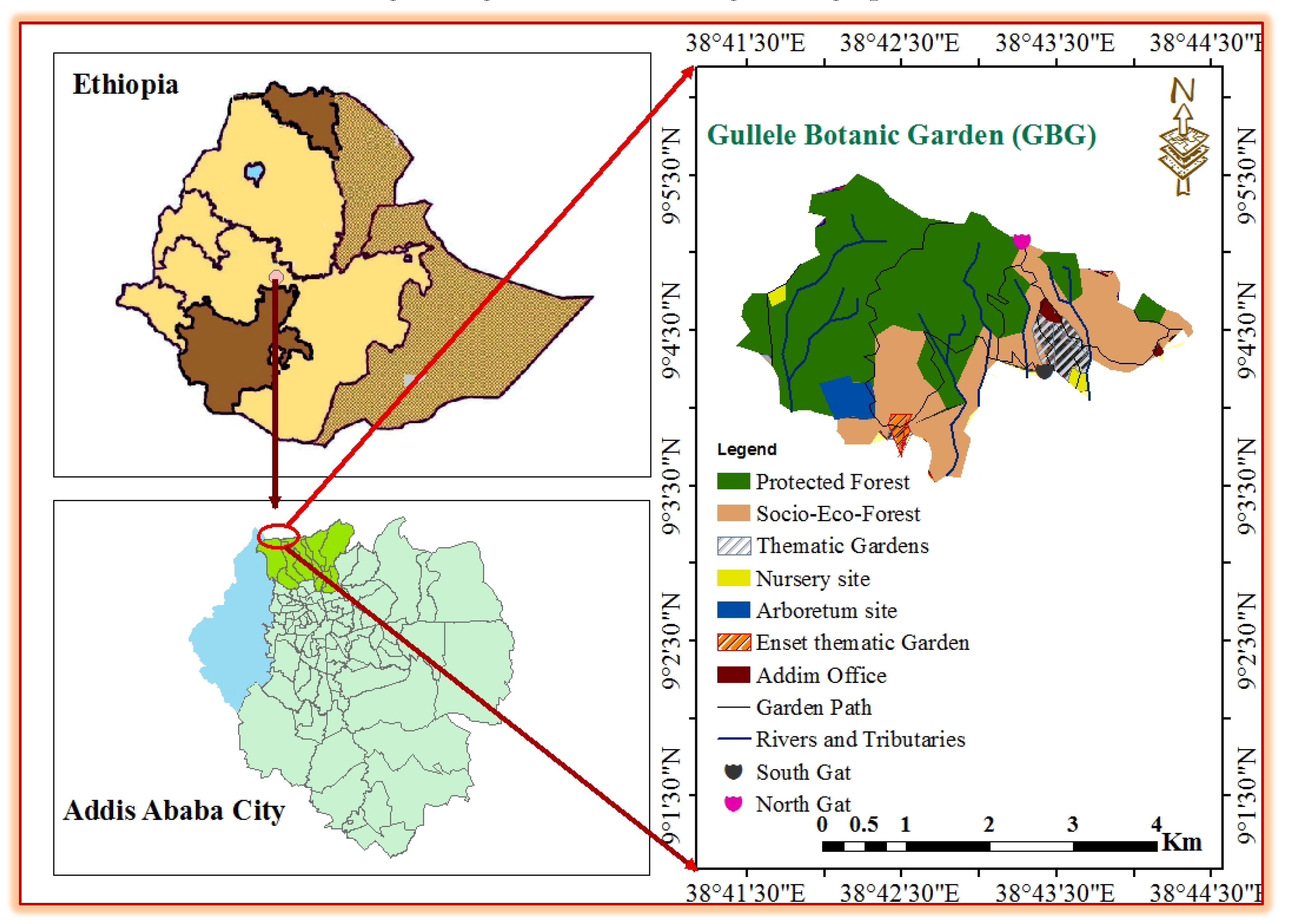
Figure 1. Map indicating the location of the GBG. Source: (Fikedu, 2021).
Preprints 116445 g001
Disclaimer/Publisher’s Note: The statements, opinions and data contained in all publications are solely those of the individual author(s) and contributor(s) and not of MDPI and/or the editor(s). MDPI and/or the editor(s) disclaim responsibility for any injury to people or property resulting from any ideas, methods, instructions or products referred to in the content.
Copyright: This open access article is published under a Creative Commons CC BY 4.0 license, which permit the free download, distribution, and reuse, provided that the author and preprint are cited in any reuse.
Prerpints.org logo

Preprints.org is a free preprint server supported by MDPI in Basel, Switzerland.

Subscribe

© 2024 MDPI (Basel, Switzerland) unless otherwise stated