Preprint
Article

Exploring the Development Trend and Key Influencing Factors of Tianjin's Industrial Heritage

Altmetrics

Downloads

51

Views

20

Comments

0

A peer-reviewed article of this preprint also exists.

This version is not peer-reviewed

Submitted:

27 August 2024

Posted:

28 August 2024

You are already at the latest version

Alerts
Abstract
Tianjin is currently in the phase of urban stock renewal, yet its industrial heritage encounters significant challenges, including constrained spatial development, a misalignment between industrial progress and the reuse of industrial heritage, and an understated cultural representation. This study applies geospatial analysis to delineate the distribution characteristics of Tianjin's industrial heritage across time, space, and typology. Moreover, the geographic detector is employed to assess the impact of various factors on the development of Tianjin's industrial heritage, ultimately elucidating the correlations between existing challenges and objective patterns. The conclusion of this paper presents three strategic approaches for the renewal of industrial heritage, emphasizing historical culture, environmental space, and sustainable development. These strategies are designed to provide a solid research foundation for protecting and revitalizing Tianjin's industrial heritage resources.
Keywords: 
Subject: Social Sciences  -   Urban Studies and Planning

1. Introduction

Tianjin is a significant hub for China's modern industrial evolution, hosting historical sites of significant industrial heritage, such as the former Beiyang Fleet Dockyard and the Mint. This city has birthed pivotal achievements in the industrial sector of New China, including the first domestically-made bicycle and wristwatch, affirming its status as one of the country's venerable industrial strongholds [1]. Therefore, Tianjin's industrial heritage exemplifies national representativeness and serves as a tangible repository of the city's industrial history [2]. In response to the "14th Five-Year Plan," [3] Tianjin has enacted a suite of policies, notably the "Tianjin Industrial Heritage Management Measures," aimed at enhancing the preservation and enduring legacy of these priceless assets. These efforts are part of a broader initiative to continually refine the legal and regulatory frameworks about Tianjin's industrial heritage, significantly enhancing the protection and adaptive reuse of the city's industrial relics.
Current research demonstrates that many scholars have delved deep into Tianjin's industrial heritage, examining its spatial organization, functional amenities, structural layout, and distinctive features, including the dynamism inherent in Tianjin's industrial heritage [4], the conceptualization and realization of Tianjin's industrial heritage corridor [5], the evolutionary narrative of Tianjin's modern industrial endeavors [6], the inventive repurposing of Tianjin's industrial heritage [7], the development of a comprehensive database encapsulating Tianjin's industrial heritage [8], and the creation of robust regulatory measures for preserving and managing Tianjin's diverse industrial heritage [9]. These perspicacious studies have furnished invaluable insights, proving instrumental in the ongoing efforts to preserve and leverage Tianjin's rich industrial heritage. However, current research also shows that the approvals for the preservation and utilization of Tianjin's industrial heritage primarily depend on policy orientations, refining regulations, and suggesting policy amendments [10,11]. As such, this condition neglects the crucial planning and design aspects that consider the temporal-spatial structure of the industrial legacy [12,13]. Therefore, There exists a gap in examining the intricate links between the distribution of Tianjin's industrial heritage and the city's historical and spatial context. Moreover, there has been insufficient use of existing research on the development of Tianjin's industrial heritage corridor and the impact of environmental factors on the current development of industrial heritage.
As efforts to preserve and leverage Tianjin's industrial heritage evolve, on-site surveys of specific industrial heritage sites underscore the multifaceted influences shaping their preservation and utilization, resulting in notable regional and structural differences, as shown:
1) Due to the diverse historical epochs of industrial heritage construction, discernible regional disparities in their preservation and utilization have emerged. For example, industrial legacies dating from the modern era to the inception of the People's Republic of China are typically designated as heritage conservation units, either actively maintained or in dormant states. Subsequently, while certain industrial heritage sites have evolved to fulfill their original functions or adopted new roles, others have been neglected, facing imminent risk of deterioration.
2)Urban spatial planning has led to distinct variations in the environments of industrial heritage sites. Notably, some sites located along North Jiefang Road and the banks of the Haihe River benefit from favorable environmental conditions. In contrast, some are situated in secluded neighborhoods or rural areas, experiencing restricted accessibility and less conducive spatial environments.
3) Local economic and industrial planning has fostered structural disparities in the strategies for developing and utilizing industrial heritages: In Tianjin, the repurposing of industrial heritage mainly focuses on functions like museums, industrial parks, and government services, according to standardized preservation practices.
4) Social and environmental factors play a pivotal role in shaping regional disparities in the condition of industrial heritage. From structural integrity to interior and exterior spaces and the overall site environment, conditions vary significantly, ranging from severe neglect and damage to meticulous preservation. These discrepancies often align with a region's geographic location, GDP, and related variables. Typically, regions with superior conditions exhibit more robust conservation efforts, while others struggle to achieve effective preservation.
The mentioned differences are becoming evident in the activities of preserving and utilizing Tianjin's industrial heritage. These efforts encounter many hindrances stemming from heritage construction's temporal and spatial characteristics and the nature of production. This constraint presents challenges for industrial heritage, consequently impeding urban development. Therefore, striking a harmonious balance between preserving and adapting industrial heritage to become a focal point of urban growth and city development has emerged as an urgent imperative. This paper aims to address this problem through a comprehensive examination of Tianjin's industrial heritage. This paper elucidates the temporal and spatial dynamics, as well as the typological characteristics of the heritage distribution, by employing geospatial analysis techniques provided by Arcgis (a Geographic Information System software), such as kernel density analysis, standard deviation ellipse analysis, centroid shift models, and conventional mathematical statistics. Furthermore, influential factors and explanatory power behind the distribution disparities of industrial heritage resources are identified to unveil the spatiotemporal distribution patterns and inherent laws of Tianjin's industrial heritage from a geographical and historical perspective. In the last, theoretical suggestions are proposed to help Tianjin's industrial heritage navigate its difficulties, providing a research base for the conservation and creative reuse of industrial heritage resources in Tianjin.

2. Research Method

2.1. Data Collection

This study examines the industrial heritage of Tianjin as cataloged in the "National Industrial Heritage List" and "China Industrial Heritage Protection Catalog," emphasizing the period from Tianjin's historic opening to the dawn of China's reform era (1860-1978). This exploration encompasses a variety of industrial sectors, including light manufacturing, print production, textile industries, transportation, communication equipment, and electronics manufacturing. This exploration focuses on the physical remnants, such as industrial sites and buildings and their associated structures. Moreover, the spatial vector data utilized in this analysis are sourced from the National Basic Geographic Information System and the National Administrative Division Information Query Platform. The data on the main flow of the Haihe River and its tributaries are confined to the administrative boundaries of Tianjin. Furthermore, the study incorporates data obtained from official statistical records on variables affecting the distribution of industrial heritage within Tianjin, including transportation, economic factors, and demographic details.

2.2. Research Methods

This study thoroughly investigates the distribution patterns and underlying historical causes of Tianjin's industrial heritage utilizing ArcGIS as the primary analytical tool, complemented by traditional mathematical statistics and supported by corroborative historical evidence. The following illustrates the methods used in this paper[14].
1)Kernel density estimation. This method quantitatively examines the spatiotemporal distribution and clustering characteristics of Tianjin's industrial heritage. Within the framework of Geographic Information Systems, this analysis method primarily evaluates and portrays the density and focal concentration of resource elements within a specified spatial boundary [15]. The foundational function as shown:
f n x = 1 nh i = 1 n · k x x i h
h>0 denotes the bandwidth, n is the total number of industrial heritage, and (x-xi) denotes the distance from the valuation point x to the industrial heritage point.
2)Gravity Migration Model. This study employs the centroid migration model to trace the spatial evolution of Tianjin's industrial heritage throughout its historical timeline. This model serves as a robust spatial analysis tool, adept at unraveling the dynamic patterns of regional resources as they shift across time and space [16]. The foundational function as shown:
x ¯ = i n m i x i i n m i , y ¯ = i n m i y i i n m i
(xi, yi) is the center of geographical coordinates of each administrative unit in Tianjin, and mi is the value of industrial heritage in each administrative unit in each historical period.
3)Concentration Index. The concentration index shows a nuanced understanding of various resource elements' distribution and specialization levels within designated areas. This paper employs the Lorenz Curve to dissect and delineate the structured characteristics of Tianjin's industrial heritage according to type, offering a precise visualization of resource distribution and thereby enhancing insight into structural nuances [17]. The foundational function as shown:
I = C K M K
C is the sum of the cumulative percentages of industrial heritage types; M is the sum of the cumulative percentages when the distribution is fully pooled; K is the sum of the cumulative percentages when the distribution is fully averaged. The value range is [0, 1], and a larger value of I indicates a higher degree of centralization in terms of type.
4)GeoDetector. The geodetector method is applied to assess how natural and social environments influence the distribution of Tianjin's industrial heritage. By calculating and analyzing the q-value within the geodetector, this approach identifies which factors explain the spatial distribution of Tianjin's industrial heritage significantly, thereby facilitating a deeper understanding of its distribution patterns and inherent characteristics [18]. The foundational function as shown:
q = N σ 2 h = 1 L N h σ h 2 / N σ 2
Nh and σh2 are the number and variance of industrial heritage, respectively; Nh and σ h 2 are the value and variance of the influencing factors of category h; L is the number of classifications of the influencing factors of category h. Not that the domain of q is [0, 1], and the larger the value of q is, the stronger the explanatory power of the indicator on the distribution of the number of industrial heritage.

3. Results and Discussion

3.1. Time Situation

3.1.1. Distribution of Industrial Heritage in Various Historical Periods
The era of formation significantly contributes to the valuation of Tianjin's industrial heritage. This section concentrates on the historical progression of Tianjin's industrial heritage, from establishing its port to the Reform and Opening-up period.
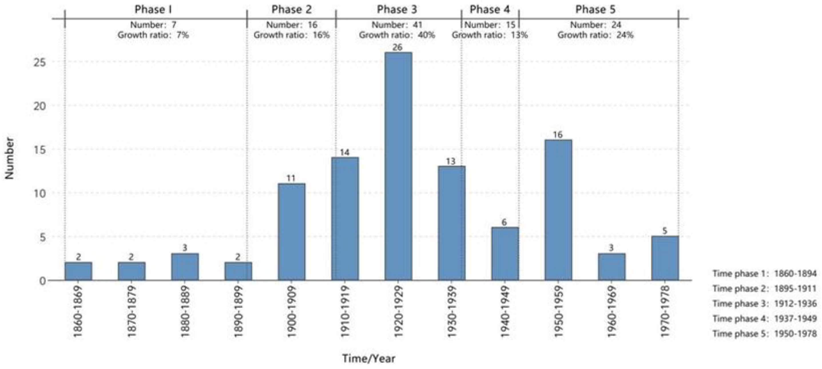
Tianjin's industrial heritage can be segmented into five key phases, each defined by historical events that caused significant societal shifts, as shown [19]:
First Phase (1860-1894): From the formal opening of Tianjin's port to the Sino-Japanese War. Second Phase (1895-1911): From the rise of the Beiyang Government to the initial years of the Republic of China. Third Phase (1912-1936): From the establishment to the prelude of the Anti-Japanese War under the Republic of China. Fourth Phase (1937-1949): From the comprehensive outbreak of the Anti-Japanese War to the inception of the People's Republic of China. Fifth Phase (1950-1978): From the founding of the People's Republic to the commencement of the Reform and Opening-up era. These periods are further analyzed in decade-long segments to discern the evolving patterns of Tianjin's industrial heritage, as shown in Figure 2.
Statistical analysis of the increases in Tianjin's industrial heritage across different periods (refer to Figure 1) reveals substantial variation. The 1912-1936 period marked a peak, comprising approximately 40% of the total heritage. The years from 1860 to 1894 represented the lowest increase, accounting for around 7% of the total. The 1937-1949 period experienced a noticeable decline, making up only about 13% of the total. In other periods, the growth in new heritage remained relatively steady.
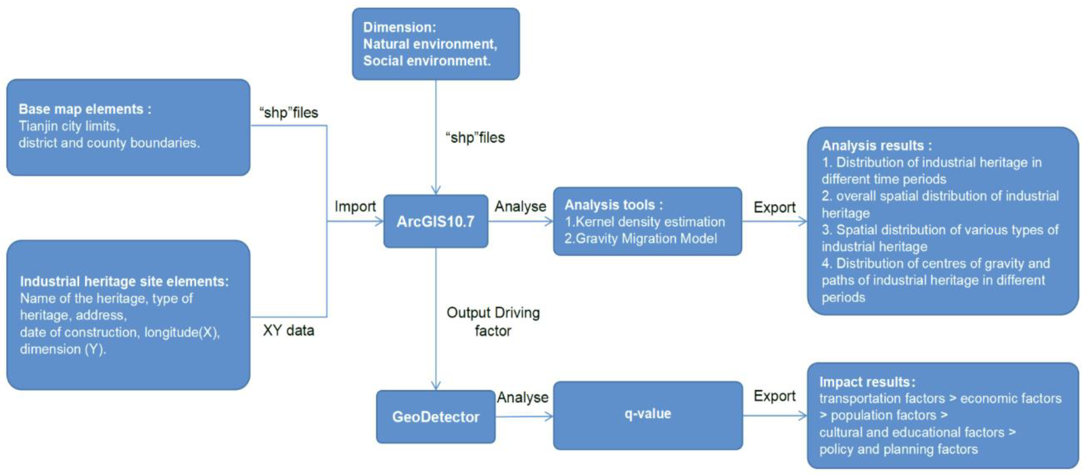
Figure 1. Data analysis process.
Preprints 116431 g001
Figure 2. Number of new additions to Tianjin's industrial heritage by historical period.
Preprints 116431 g002
Figure 3 presents Tianjin's industrial heritage distribution, emphasizing the clustered nature of new additions across various periods. According to statistical analysis, during the 1860-1894 period, Tianjin saw the introduction of seven industrial heritage sites, with five located along the Haihe River in the Binhai New Area and two along the river in Tianjin's Heping District. This timeframe coincided with the "Sino-British Tianjin Treaty Additional Agreement," which eased local policies and the business environment, positioning Tianjin as a key economic and trading center in the north [20]. Concurrently, Haihe's maritime activities blossomed, extending from the estuary directly to Tianjin's urban core, prompting the development of significant maritime-related industries, including new shipyards and enterprises like Swire, thus accelerating Tianjin's modernization trajectory [21,22].
Between 1895 and 1911, Tianjin witnessed the establishment of sixteen new industrial heritage sites, with fourteen strategically located within the central urban districts and the remaining two situated in Xiqing and the burgeoning Binhai New Area. This period was marked by China's significant defeat in the First Sino-Japanese War and the subsequent loss of naval dominance. Under Yuan Shikai's leadership in Zhili Province, his implementation of the 'New Policies' spurred substantial infrastructural advancements. Notable endeavors included the construction of pivotal transportation hubs like Tianjin West Station, Tangguantun Railway Station, and Jinghai Railway Station, alongside the historical site of the former Mint Factory. The focus of Tianjin's modernization shifted towards the 'Hebei New District' and other non-concession zones along the Southern Canal and Ziya River [23], signifying a historical pivot in industrial development towards areas not restricted by foreign concessions.
From 1912 to 1936, Tianjin established forty-one new industrial heritage sites, primarily concentrated rather than dispersed across the region. Thirty-five of the sites were strategically located within the city's six central districts. The remaining sites were distributed, with three in the burgeoning Binhai New Area, two in Xiqing District, and one in Dongli District. With the advent of the Republic of China in 1912, Tianjin experienced a surge of vitality. National industries flourished because of the favorable business conditions in the concession zones, supported by policy initiatives from the Hebei New District. This industrial expansion predominantly radiated northwestward along the Southern and Northern Canals and southeastward along the mainstream of the Hai River, marking a robust phase in Tianjin's economic development [24].
From 1937 to 1949, Tianjin witnessed the addition of fifteen new industrial heritage sites, with eleven situated within the city's central districts and four in the Binhai New Area. As the Sino-Japanese War intensified, Tianjin emerged as a crucial transportation hub in the northern zone occupied by Japan. During this period, the Japanese established various industrial relics, such as the old Dagu Factory and the Xingang Shipyard, to transport resources from North China to Japan [25]. The distribution of industrial heritage during this era, closely aligned with the course of the Hai River, exemplifies Tianjin's historical evolution as a pivotal hub for integrated land and maritime transportation.
From 1950 to 1978, Tianjin embraced the addition of fourteen industrial heritage sites, with a distribution of ten in the city center, seven across its encircling districts, and another seven in the strategic Binhai New Area and Ji County. In the wake of the People's Republic of China's inception, the ambitious First and Second Five-Year Plans were systematically executed, paralleled by comprehensive reforms of Tianjin's riverine networks. Capitalizing on the robust industrial frameworks of its central and Binhai New Areas, Tianjin embarked on the construction of numerous industrial enterprises, instrumental in spearheading national construction, enhancing productivity, and bolstering the economy [26,27,28]. This industrial proliferation gradually extended into the city's peripheral districts. Moreover, the industrial legacies within Ji County serve as a testament to the extraordinary military fortification efforts undertaken in the northern highlands amidst the Sino-Soviet discord.

3.1.2. Distribution Center of Gravity and Migration Path

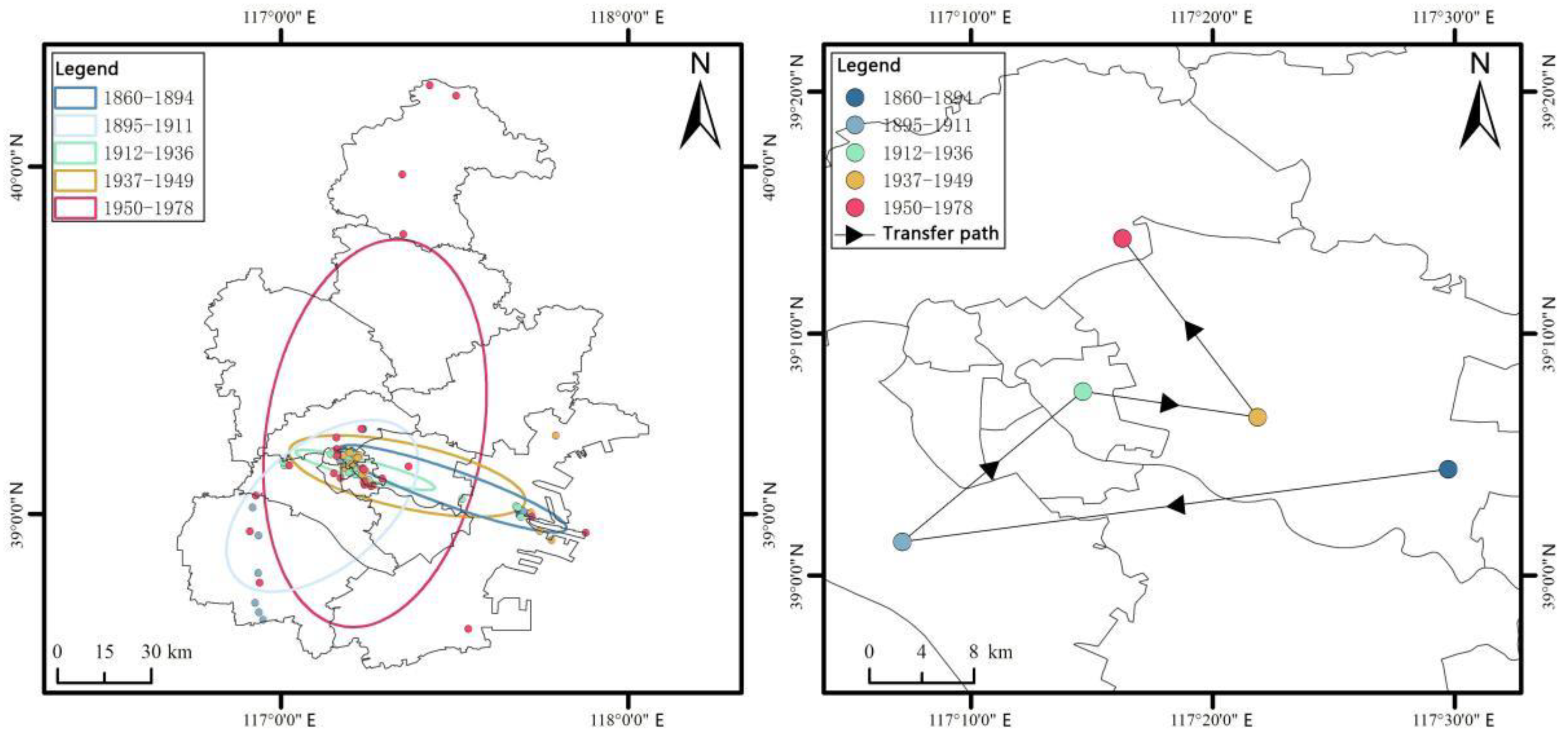
The Standard Deviation Ellipse (SDE) analysis provides a comprehensive quantitative framework to evaluate the balance, centrality, and overarching characteristics of spatial distributions of elements. The SDE analysis, as illustrated in Figure 4(a), reveals that during the periods 1860-1894, 1912-1936, and 1937-1949, the spatial distribution of Tianjin's industrial heritage was strongly directional and centripetal, closely associated with the main flow of the Haihe River. In contrast, the 1895-1911 and 1950-1978 periods demonstrated a diminished directionality and centripetal force, lacking a distinct correlation with Tianjin's aquatic networks, and displayed a discernible shift towards inland regions.
Analyze results identified the center of gravity to elucidate the trajectories and underlying causes of the shifts in industrial heritage focal points. Figure 4(b) reveals four significant shifts in the distribution center of Tianjin's industrial heritage. These shifts sequentially progress from the eastern coastal areas → to the western inland regions → into the central urban zone → towards the middle and lower sections of the Haihe River → and finally, advancing into the northern inland zones.
The center of gravity migration analysis shows that from 1860 to 1911, Tianjin's industrial heritage construction transitioned significantly from the eastern coastal zones to the western inland areas. This transition signifies a strategic shift in Tianjin's industrial development from the coastal regions and the Hai River district to the more stable terrestrial corridors and canal-adjacent areas in the west.
Between 1895-1936 , there was a significant geographic shift in the distribution centroid, marking a pivotal era characterized by the proliferation of leased territories in Tianjin under Yuan Shikai's direct governance. During this period, Hebei's new districts and the concession areas transformed into highly stable and secure development zones. Internationally, various nations initiated industrial developments within these concessions, leveraging the strategic navigational advantages of the Hai River to enhance their commercial activities.
Between 1860-1894 and 1937-1978, the center of gravity migration exhibited remarkable stability. Following the establishment of Zhangguizhuang Airport, a strategic shift directed Tianjin's transportation sector towards the more accessible downstream areas of the Hai River, thereby improving connectivity to both the airport and port facilities. Subsequently, after the founding of the People's Republic of China, Tianjin initiated the development of state-owned industrial enterprises, primarily focusing on the city's central urban area and its surrounding suburbs.
The analysis of industrial heritage distributions across various historical stages reveals their alignment with the societal contexts of each period and a significant correlation with the main course of the Hai River. To explore the coupling relationship between industrial heritage and urban space, it is essential to analyze the spatial distribution trends over comprehensive time periods. This methodology provides an overall perspective on the spatiotemporal distribution of industrial heritage, enabling the derivation of objective laws that govern the interplay between industrial heritage and urban space.

3.2. Space Situation

3.2.1. The Spatial Distribution of Industrial Heritage Resources in Tianjin

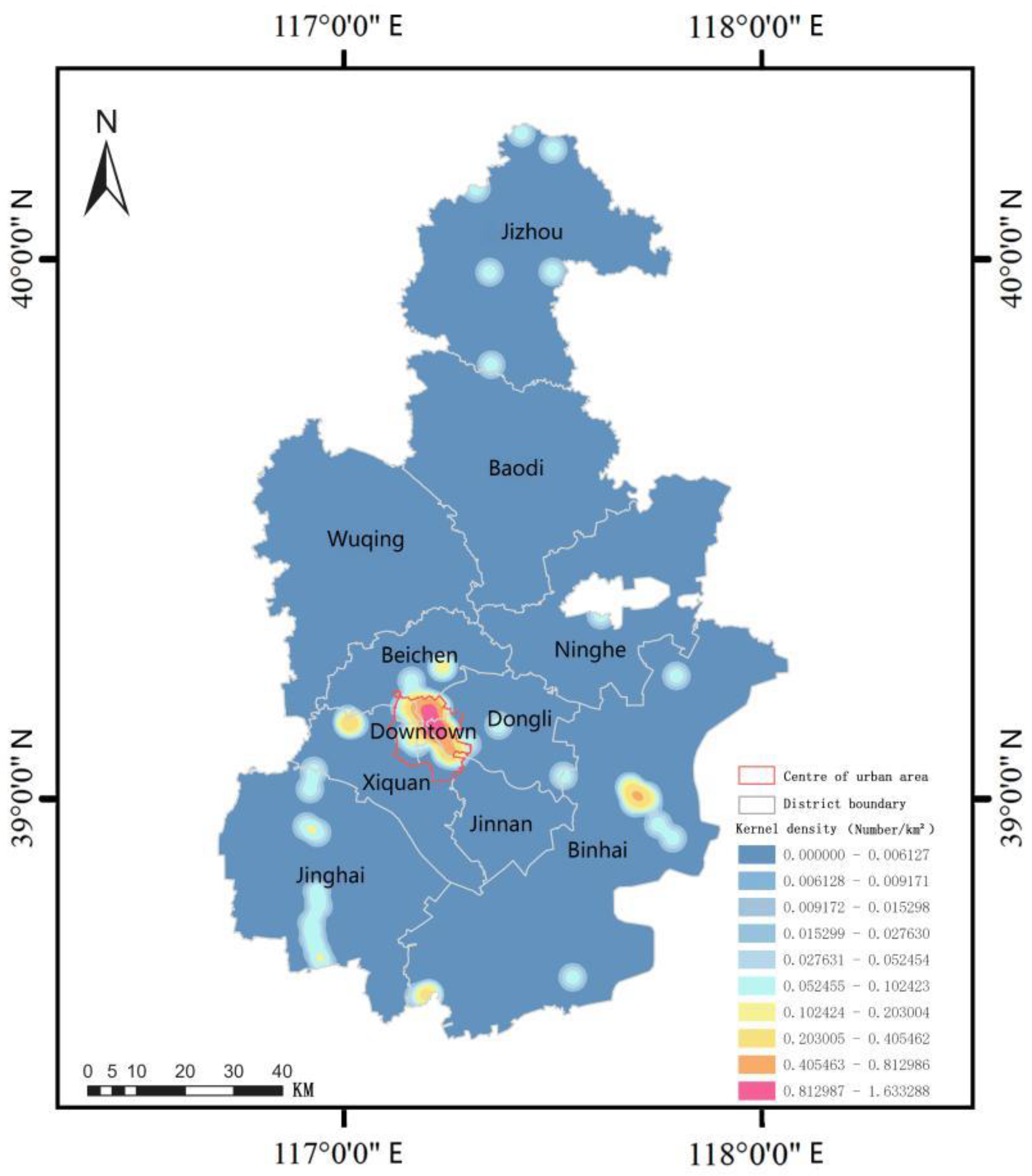
Figure 5 delineates the spatial distribution of industrial heritage in Tianjin, illustrating these heritage sites' spatial distribution characteristics and concentrations. The map in Figure 4 demonstrates that industrial heritage resources predominantly follow a linear distribution pattern, characterized by density at the extremes and sparsity in the center along the Hai River. This pattern is mirrored along the northern and southern trajectories of the Grand Canal through Tianjin. These linear trends converge within the central urban district, whereas a more sparse, punctate distribution characterizes Tianjin's northern mountainous regions and surrounding suburban counties.
From the perspective of the entire urban area of Tianjin, the central urban district contains 66 industrial heritage sites, accounting for 58.92% of the total. Conversely, the suburbs host 46 sites, representing 41.07% of the total, and are notably less prevalent compared to the central district. The Binhai New Area is particularly significant among these suburban distributions, comprising 43.48% of the suburban industrial heritage sites.
The distribution of industrial heritage sites shows marked disparities among the six central districts of Tianjin. Hebei District stands out with 18 sites, accounting for 27.28% of the area's total industrial heritage. It is closely followed by Heping District, which boasts 15 sites, representing 22.72% of the total. The Approximately 10 industrial heritage sites are located in each of Hongqiao District, Hedong District, and Hexi District, collectively representing 43.94% of the central urban area's industrial heritage.districts of Hongqiao, Hedong, and Hexi each feature approximately ten heritage sites. In contrast, Nankai District has the sparsest distribution, with only four sites comprising just 6.06% of the total industrial heritage within these central districts.
Based on the comprehensive analysis of the aforementioned temporal and spatial trends, the advantageous distribution of industrial heritage in Tianjin's central urban area is closely related to the period of the city's fastest industrial development. Notably, during the peak period of industrial growth from 1895 to 1936, Tianjin saw the addition of 57 new industrial heritage sites, constituting 50.89% of the total inventory. Specifically, in this period, the central urban district welcomed 43 new sites, accounting for 75.44% of this increase. This pattern illustrates that the foundational and growth phases of modern industry in Tianjin were primarily focused on the central urban area. It underwent two major periods of factory establishment: the time when Yuan Shikai reclaimed Tianjin and established the Beiyang Government to promote industry and commerce directly under its control, and the subsequent era of significant national industrial growth following the establishment of the Republic of China, which marked a robust development in national industries, landmark industrial sites such as Tianjin West Station, Yongli Alkali Factory, and Huaxin Cotton Mill emerged [29].

3.2.2. The relationship between the spatial distribution of industrial heritage and the spatial structure of the water systems.

In contemporary Tianjin, industrial development did not result in expansive, contiguous industrial zones; instead, it was strategically distributed along the banks of the city's main waterways [30]. Regions distant from these aquatic systems have sporadic industrial heritage sites. To effectively explore the interrelation between Tianjin's industrial development and its urban spatial configuration, it is crucial to examine the linkage between the waterway structures and the spatial distribution of industrial heritage across the metropolitan area. Such an examination facilitates a deeper understanding of the underlying dynamics that dictate the relationship between urban space and the distribution of industrial heritage.
Industrial heritage sites situated within the Tianjin water system represent 84.82% of Tianjin's entire industrial heritage portfolio. Mathematical Statistics of these sites, as shown in Table 1, indicate that industrial heritage along the main channel of the Haihe River comprises 51.58% of the total within these aquatic domains. The industrial heritage sites along the South and North Canal systems make up 23.16%, while those associated with other water systems contribute 25.26%.
In Tianjin's central urban districts, a significant proportion of industrial heritage sites are strategically positioned along the main channel of the Haihe River, comprising 30.36% of the city's total industrial heritage. Other water systems and the South and North Canal systems account for 19.64% and 5.36% of the total, respectively. The Binhai New Area prominently features industrial heritage sites along the Haihe River, contributing 12.50% to the total. In Jinghai and Xiqing districts, the industrial heritage sites are primarily distributed along the South and North Canal systems, accounting for 8.93% and 4.46% of the total, respectively. In the Beichen and Dongli districts, these sites are found along both the Canal systems and the Haihe River, with one significant site in each setting. Meanwhile, in the Jizhou District, industrial heritage sites located within other water systems make up 1.79% of Tianjin's overall industrial heritage count.
Through the examination of the spatial distribution of Tianjin's industrial heritage relative to its alignment with the area's water systems and taking into account temporal trends, it becomes evident that historical influences shaped by distinct phases of social and economic development have prompted unique divergences in industrial construction sites. Through the above research, it has been found that the spatial location of industrial heritage and its association with the spatial structure of the water system are linked by intrinsic historical construction elements [31]. Therefore, the following section focuses on the spatial distribution analysis of the type characteristics of Tianjin's industrial heritage, utilizing these type characteristics and their distribution to explore the connection between industrial construction elements and urban space.

3.3. Type Characteristics

3.3.1. Structured distribution characteristics of industrial heritage types

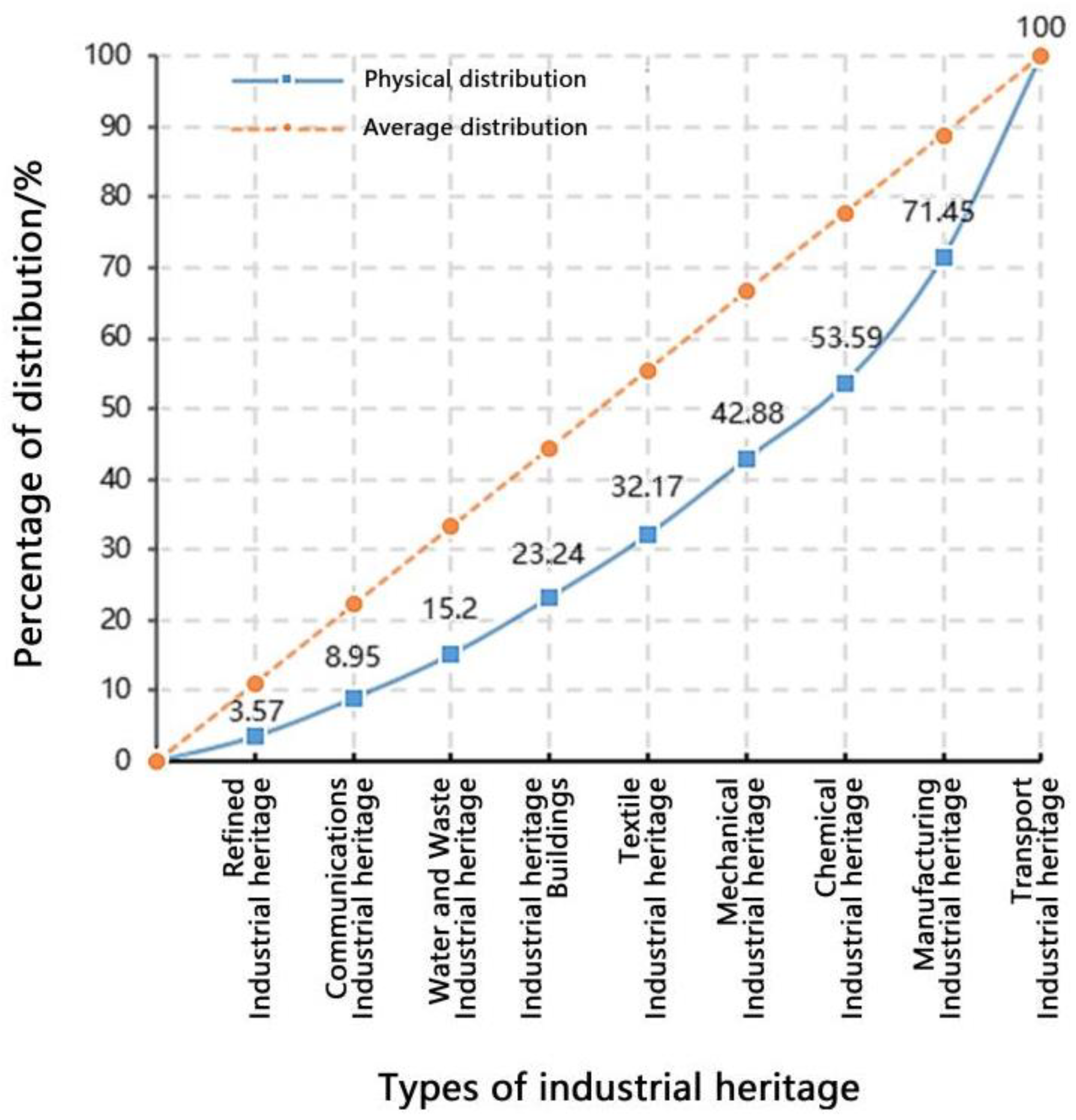
The Lorenz curve depicted in Figure 6 illustrates that the concentration index for Tianjin's industrial heritage is -0.37, which underscores a notably low and uneven distribution of industrial heritage types throughout Tianjin, highlighting a predominantly dispersed structural pattern.
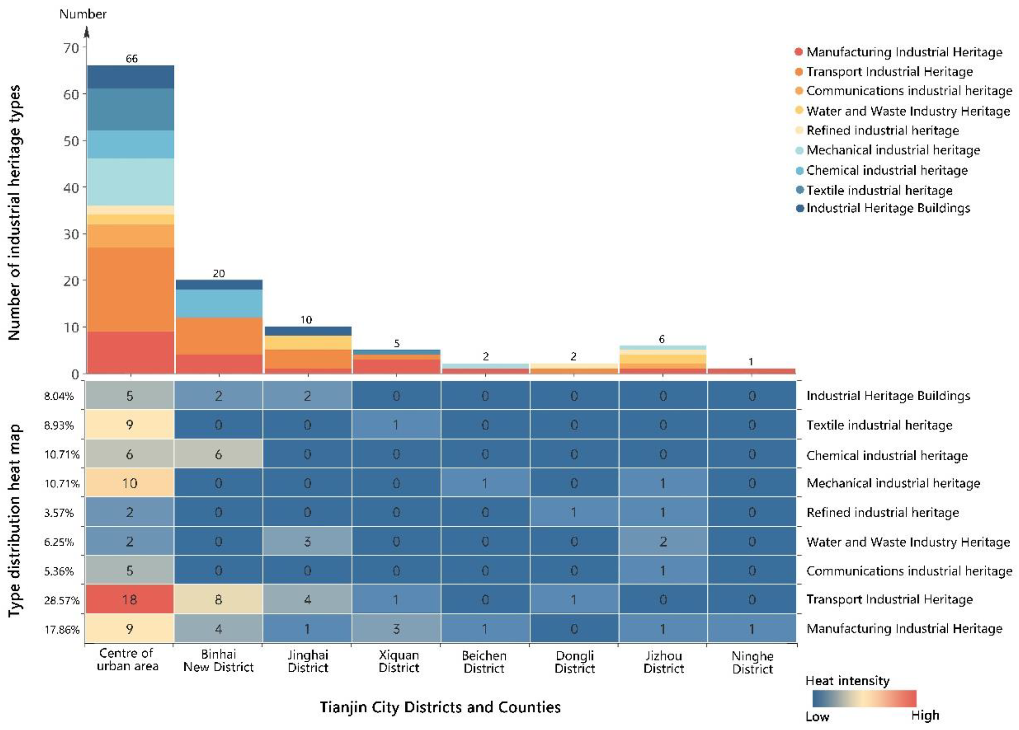
The distribution of industrial heritage types across Tianjin's districts and counties (as illustrated in Figure 7) indicates that transportation-related industrial heritage sites, totaling 32, account for 28.57% of the total and command a prominent advantage. Manufacturing industrial heritage follows with 20 locations, constituting 17.86% of the total. Both chemical and mechanical industrial heritage sites are represented by 12 locations each, comprising 10.71% of the total. Textile industry heritage and buildings dedicated to industrial heritage tally 10 and 9 sites, representing 8.93% and 8.04% of the total. Sites associated with the communications, water and waste management, and refining industries are relatively less common, with 6, 7, and 4 totals, corresponding to 5.36%, 6.25%, and 3.57% of the overall distribution, respectively.
The analysis indicates that the spatial distribution of Tianjin's industrial heritage types is not centralized but rather mirrors the patterns seen in regional spatial distributions, spreading diffusely along water systems. Transportation and manufacturing industrial heritage emerge as the predominant categories, aligning seamlessly with the era of Tianjin's modern industrial advancement. This pattern reflects Tianjin's unique historical significance as the economic heart of modern Northern China and the northern transportation center during the Japanese occupation, encapsulating the city's deep industrial historical and cultural layers.

3.3.2. Industrial Type Distribution

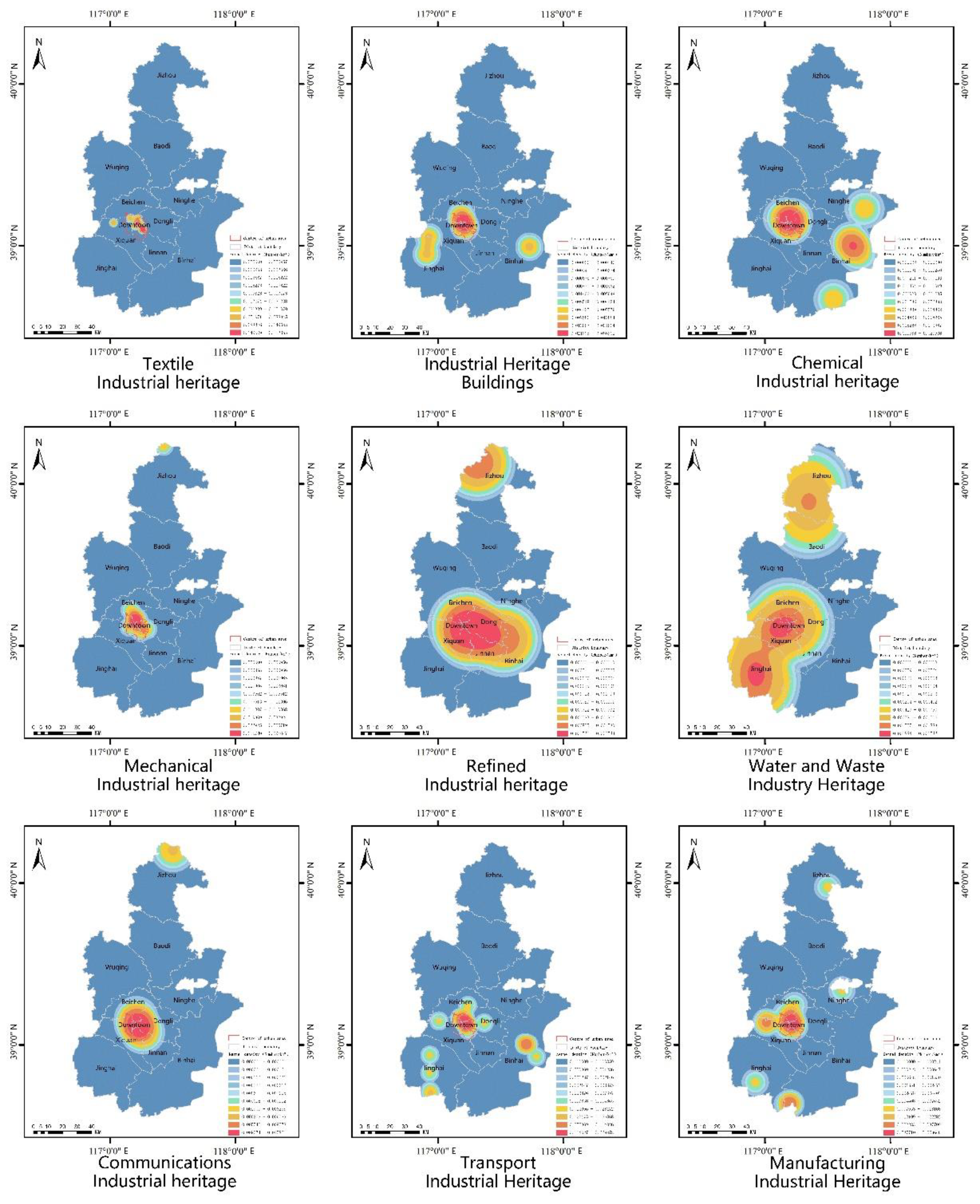
Figure 8 illustrates the distribution patterns of various types of industrial heritage in Tianjin, highlighting the density and directional trends of these heritage types throughout the entire geographic area of the city. From the perspective of the urban area of Tianjin, every category of industrial heritage is represented in Tianjin's central region, where they collectively exhibit a pronounced clustered distribution.
In Tianjin's northern region, Jizhou District exemplifies the distribution of industrial heritage, primarily characterized by water and waste management, communications, and refining industries. Notable landmarks in this area include the Dazhuang Drainage Station, Sanchakou Pumping Station, and the former site of Tianjin Radio Station's wartime broadcast facility. These sites highlight Jizhou District's historical efforts to manage water-related disasters through comprehensive river regulation projects initiated after the founding of the People's Republic of China and its strategic preparedness during the tense Sino-Soviet relations [32,33].
Tianjin's industrial heritage in the eastern region is concentrated in the Binhai New Area in the southeast. Since the port's inauguration in 1860, the Binhai New Area has leveraged its strategic maritime and shipping advantages to become a pivotal industrial hub. This area is dotted with significant transportation heritage sites, including extensive shipyards, ports, and docks. Additionally, it is home to notable chemical industry landmarks such as the former Yellow Sea Chemical Industry Research Society, the erstwhile Tanggu Oil Depot of the Asia Oil Company, and the historic Yongli Soda Factory. These landmarks encapsulate the rise of modern foreign enterprises, the burgeoning of national capital trade, and the thriving maritime industry in Tianjin.
Tianjin's industrial heritage is primarily concentrated in Jinghai District, located in the southwest of the city's western region. The development of this heritage unfolds in two key historical phases. Following Yuan Shikai's reconquest of Tianjin, the Beiyang government vigorously promoted development around the new Hebei area and the North and South Grand Canals. This strategic initiative aimed to establish a developmental equilibrium opposing the foreign-controlled leased territories, leading to the establishment of several key transportation-related industrial heritage sites along the South Grand Canal in Jinghai. The second phase occurred post-1949, with significant enhancements in the South Grand Canal's infrastructure, catalyzing the construction of various water and waste management industrial heritage sites. These developments underscore Jinghai's historical focus on canal-centric industrial growth, driven by evolving demands for transportation and societal production, shaping its unique industrial legacy.
The preceding analysis highlights the profound impact of Tianjin's strategic geographic location and the shifts in modern societal demands on the composition and spatial distribution of its industrial heritage. These factors illustrate the industrial production activities that have unfolded within distinct spatial and temporal contexts, thus shaping Tianjin's unique industrial and cultural history.

3.4. Influencing Factors and Explanatory Power of Distributional Differences

The comprehensive review of existing research emphasizes the profound connection between the emergence and evolution of Tianjin's industrial heritage and its environmental setting. This study extends current research and delineates the natural and social environmental dimensions as critical evaluative axes for assessing the spatiotemporal distribution of industrial heritage. Within the natural environment dimension, indicators such as topography, water systems, and climate, along with nine specific evaluation metrics, are systematically categorized [14]. Conversely, in the social environment dimension, transportation, economic, population, cultural-education, and policy-planning factors, along with their nine associated evaluation metrics, are methodically grouped. Therefore, this paper quantifies the impact of these indicators on the variance in the distribution of Tianjin's industrial heritage using the geographic detector.
Geodetectors are frequently employed to assess the spatial heterogeneity of individual variables and to identify potential causal links between pairs of variables. Table 2 outlines the findings derived from using geodetectors to assess the impact of various determinants on the influence exerted by Tianjin's industrial heritage. Here, q values range from 0 to 1, with higher values indicating a more pronounced influence of the driving factors and lower values indicating a lesser influence. According to these q values, the natural environment does not exert a significant influence on the spatial distribution of Tianjin's industrial heritage. Conversely, the social environment markedly influences the variation in the distribution of industrial heritage across Tianjin. With the exception of policy and planning considerations, all other measured indicators are impactful.
In the realm of the social environment, the explanatory potency of various indicators on the spatial disparities of Tianjin's industrial heritage, ranked in descending order of influence, is as follows: transportation factors > economic factors > population factors > cultural and educational factors > policy and planning factors. Notably, transportation factors underpin the distribution of Tianjin's industrial heritage, demonstrating the most robust explanatory power (0.702). Examining Tianjin's modern industrialization process reveals that areas with relatively advantageous road transportation tend to have denser distributions of industrial heritage. These areas also have significant advantages in the protection and development of industrial heritage. The Miansan Creative District and the Tiantuo Creative Park are exemplary models of industrial heritage preservation and development in Tianjin. Economic factors (0.422), population factors (0.325), and cultural and educational factors (0.257) exert a considerable influence on the distribution of Tianjin's industrial heritage, as these factors are pivotal in supporting its protection and development. For instance, the six urban districts and the Binhai New Area typically expedite and streamline policy-making for the conservation and utilization of industrial heritage compared to other districts and counties. Worker communities were originally established as supporting facilities for industrial heritage construction. During later stages of urban development, the continuous changes in community demographics, the development of new communities, and the relocation and demolition of old communities have led population factors to occupy a significant position among the influencing factors of industrial heritage [34] . Owing to the higher aggregate GDP and the more abundant cultural, educational, and scientific industries in the central urban area and the Binhai New Area, the potential for repurposing industrial heritage is enhanced, accompanied by a broader spectrum of methods and approaches.
In Tianjin's modern industrialization trajectory, the strategic placement of industrial construction is predominantly influenced by transportation considerations. Efficient transportation infrastructure is instrumental in streamlining the processing and logistics of industrial raw materials, thereby bolstering economic efficiency [35]. As a result, the natural environment plays a secondary role in Tianjin's industrial expansion, which is reflected in the limited explanatory influence of the natural environment on the spatial variations of Tianjin's industrial heritage as assessed by geographic detector analysis.

4. Conclusions

4.1. Objective Law

This investigation employs spatial geographic analysis and statistics to thoroughly examine and synthesize the temporal evolution, spatial configurations, and typological attributes of the 112 industrial heritage sites in Tianjin. The conclusions drawn from the study delineate the following patterns:
1)Time situation
The origins of Tianjin's industrial heritage can be traced back to the industrial activities initiated by various foreign powers following the opening of the port in 1860, catalyzing the city's modernization efforts. Over time, the number of industrial heritage sites in Tianjin has exhibited an overall growth, punctuated by periodic fluctuations. Historically, transportation-related industrial heritage predominated from 1860 to 1949. However, after 1950, the focus shifted towards mechanical industrial heritage and architectural heritage buildings. A notable turning point occurred from 1912 to 1936, during which the count of industrial heritage sites experienced fluctuations—a decline followed by a subsequent rise. Examining the socio-historical contexts of different periods, it becomes evident that the distribution of Tianjin's industrial heritage closely mirrors the political landscape and urban development of each era [36]. This correlation explains the regional disparities in the conservation and utilization of industrial heritage, rooted in distinct historical construction phases.
2)Spatial situation
Tianjin's industrial heritage exemplifies the typical distribution traits of a coastal city's industrial legacy, primarily following linear patterns along the city's river systems and converging in the central urban district. Additionally, parts of this heritage are sporadically scattered as isolated points across the northern mountainous regions and other suburban counties. Tianjin's industrial heritage is characterized by a strong reliance on transportation corridors. The distribution of these heritage sites demonstrates a relatively weak association with the natural characteristics of rivers but a pronounced correlation with their navigational attributes. Within the city's boundaries, the distribution of industrial heritage is notably uneven: a dense concentration is observed in the central urban area, while the Binhai New Area and Jinghai District, though hosting simpler varieties of heritage types, contain a larger number of sites; other areas experience sparse distribution or complete absence. In Tianjin's urban planning, development, and renewal activities, a practical issue has gradually emerged: the surrounding environmental space often fails to meet the planning and development needs when updating the stock of industrial heritage. These issues have a bidirectional influence on the spatial distribution pattern of Tianjin's industrial heritage. On the one hand, the modern urban spatial structure of Tianjin is the primary reason for the linear distribution pattern of industrial heritage. On the other hand, the current efforts to update Tianjin's industrial heritage stock face developmental challenges due to the differentiated geographical spatial environments.
3)Distribution type characteristics
The distribution of industrial heritage types in Tianjin features a distinctly dispersed structure. Transportation-related heritage ranks as the predominant category, followed by manufacturing and communications heritage. In contrast, water and waste management and refining heritage occupy relatively minor positions. Significant clusters of transportation and chemical industrial heritage are found in Tianjin's central urban area, the Binhai New Area, and Jinghai District. Manufacturing heritage primarily concentrates in the central urban area and the Xiqing and Jinghai districts, while other types are variably distributed across Tianjin's districts. The nature of industrial heritage mirrors the scope of historical industrial activities and shapes the internal spatial systems and structures of these sites. A significant challenge in the renewal of industrial heritage stock is the conflict between new business forms and existing heritage spaces. This dynamic is critical for fostering positive development within these spaces, preserving their cultural legacy, and achieving their renewal.
4)Influencing factors and explanatory power
The social environment exerts a more pronounced influence than the natural environment on industrial heritage. In analyzing these effects, the hierarchy of impact is as follows: transportation factors > economic factors > population factors > cultural and educational factors. Within the social context of industrial heritage sites, obstructed transportation networks, isolated populations, sluggish economic growth, overlooked cultural industries, and bottlenecks in urban planning and development are identified as the primary reasons for the significant discrepancies in the protection and utilization of Tianjin's industrial heritage. These factors also pose substantial challenges that could impede the future development of Tianjin's industrial heritage.

4.2. Policy Recommendations

Tianjin's industrial heritage stands as a testament to the city's journey toward modernization and serves as a crucial material representation of its regional culture. Drawing from the identified distribution patterns and causal analysis of Tianjin's industrial heritage, the following policy recommendations are proposed to navigate the future protection and utilization of these invaluable assets:
1) Culture and History: The integration of industrial heritage with historical tapestry fosters the preservation of regional industrial cultural heritage, enhances the quality of public cultural services, and stimulates the collaborative development of cultural tourism, thereby enhancing the overall cultural tourism experience.
Drawing from the temporal distribution characteristics of Tianjin's industrial heritage, its development and utilization have been harmonized with the historical narrative of the city's modern industrial evolution, giving rise to distinctive industrial tourism initiatives like the "Modern Industrial Historical Routes" and "New China Industrial Construction Routes." These initiatives are designed to bolster the "See Modern China through Tianjin" tourism brand, conserve the industrial legacy, and establish a groundwork for the differentiated protection and utilization of industrial heritage [37]. This strategy fosters a development model that combines continuity with diversity across different epochs. Incorporating the spatial distribution characteristics of Tianjin's industrial heritage, which should be seamlessly woven into the planning and construction scope of the Haihe Cultural Belt, emphasizing the preservation of cultural heritage, delving deep into the cultural essence, all the while crafting a unique urban image and nurturing a vibrant cultural atmosphere [38].
2) Environmental Space: Refining urban spaces and transportation networks contributes to enhancing the environmental ambiance of industrial heritage sites, enriching public service offerings, and advancing high-quality urban development.
Refining urban spaces and transportation networks contributes to enhancing the environmental ambiance of industrial heritage sites, enriching public service offerings, and advancing high-quality urban development [39,40,41,42,43,44]. Critical to this effort is bringing industrial heritage sites that urgently need protection yet are currently unused and unprotected into the conservation framework. Guided by the spatial planning strategies of "Compact and Vibrant Jin City" and "Innovative and Livable Bin City," it is crucial to tailor and enhance the environmental conditions of these sites appropriately [45]. In Jin City, it is essential to enhance the environments of industrial heritage sites and improve transportation accessibility, repurposing underutilized areas into reserves for high-quality development. In Bin City, expanding spatial boundaries and improving surrounding public services are recommended, setting the stage for urban development and fostering high-quality growth in the region [46].
3) Sustainability: To align with the optimization of the industrial structure, it is important to harness the positive impact of the cultural industry, foster social collaboration, and promote urban prosperity and development.
Since the launch of the "14th Five-Year Plan," Tianjin has strategically targeted the functional orientation of "one base and three zones," achieving significant strides in optimizing its industrial structure and strengthening its economic foundation[47]. Utilizing optimization strategies such as "dual belts aggregation, twin cities optimization, intelligence valley upgrading, and group linkage," the city has integrated service industries, revitalized industrial remnants, and exploited the unique spatial features of various types of industrial heritage to refine spatial configurations[48]. This strategy has involved expanding methods of industrial heritage protection and utilization[30], promoting differentiated development in this area, and thus establishing a multidimensional framework for the protection and utilization of Tianjin's industrial heritage[49]. Moreover, the city has optimized the distribution of cultural resources, building upon industrial heritage to foster cultural industries, encouraging community engagement in public cultural services, enhancing public cultural service mechanisms, supporting community cultural activities, fully leveraging social resources, and utilizing demographic dynamics to activate industrial heritage [50,51,52]. This strategy includes creating cultural activity platforms that are both popular and accessible, with an emphasis on integrating science, education, and culture with industrial heritage[53], continually injecting new vitality into the city.

Author Contributions

Software, T.L. and Y.L.; investigation, T.L. and Y.L.; data curation, T.L. and Y.L.; writing—original draft preparation, T.L. and Y.L.; writing—review and editing, T.L. and Y.L.; supervision, Y.L. All authors have read and agreed to the published version of the manuscript.

Funding

This research received no funding.

Data Availability Statement

Data be available from the corresponding author by request.

Conflicts of Interest

The authors declare no conflict of interest.

References

  1. National Development and Reform Commission. National old industrial base adjustment and transformation plan. Available online: https://www.gov.cn/gongbao/content/2013/content_2441018.htm (accessed on 2 February 2024).
  2. Luo, S. Leading Early Modern Civilisation: Tianjin Witnesses to 100 Years of China; Tianjin People Press: Tianjin, China, 2005; pp. 1–4. [Google Scholar]
  3. China.gov.cn. Circular of the National Development and Reform Commission and other departments on the issuance of the "14th Five-Year Plan" to support the high-quality development of demonstration zones for industrial transformation and upgrading in old industrial cities and resource cities. Available online: https://www.gov.cn/zhengce/zhengceku/2021-12/01/content_5655185.htm (accessed on 2 February 2024).
  4. Ren, B.B.; Wang, J.S.; Xiao, S.Y.; Li, J.H.; Li, H.X. Research on the Vitality of Industrial Heritage in Central Urban Area of Tianjin Based on Multi-Source Data. Modern Urban Research 2023, 5, 59–67+75. [Google Scholar]
  5. Aoki, N.; Yan, F.; Xu, S.B.; Ji, H. Composition and Characteristics of Industrial Heritage Cluster in Tianjin. Architectural Journal 2014, S2, 7–11. [Google Scholar]
  6. Li, J.X.; Cai, L.W.; Yu, Z.R. Study on the spatial and temporal evolution characteristics of industrial land in old industrial cities in China--Tianjin as an example. Planners 2021, 00, 21–32. [Google Scholar]
  7. Ren, Y.L.; Guo, L.J. Exploration and Practice of Protection and Utilization of industrial Heritage in Tianjin. Urban Studies 2018, 10, 140–143+155. [Google Scholar]
  8. Xu, S.B.; Zhang, J.H.; Aoki, N.; Wu, C. Construction of GIS Database for Industrial Heritage in Key Cities:Taking Tianjin as AIV Example.Journal of Industrial Architecture. Industrial Construction 2015, 6. [Google Scholar]
  9. Yan, M.; Aoki, N.; Xu, S.B. Grading Protection of Industrial Heritage of Tianjin Soda Plant Based on Value Evaluation. Industrial Construction 2015, 5, 34–37. [Google Scholar]
  10. Deng, J.; Chen, Y. On the Legal Protection of Industrial Heritage. China Anc. City 2018, 3, 68–71. [Google Scholar]
  11. Guo, J.; Li, H.; Zhang, Y. Industrial Heritage Preservation Method Integrating with Urban Development: The Case of Chongqing. New Archit. 2016, 3, 19–24. [Google Scholar]
  12. Liu, B. A Review of Industrial Architecture Heritage Research in China. New Archit. 2012, 2, 4–9. [Google Scholar]
  13. Zhang, J.; Cenci, J.; Becue, V.; Koutra, S.; Loakimidis, C.S. Recent Evolution of Research on Industrial Heritage in Western Europe and China Based on Bibliometric Analysis. Sustainability 2020, 13, 5348. [Google Scholar] [CrossRef]
  14. Li, C. Distribution situation and Attribution of cultural Heritage in Yangtze River Economic Belt:A Case Study on National Key Cultural Relics Protection Units. Nanjing Journal of Social Sciences 2022, 7, 163–172. [Google Scholar]
  15. Zhang, J.; Cen, C.J.; Becue, V.; Koutra, S. Analysis of spatial structure and influencing factors of the distribution of national industrial heritage sites in China based on mathematical calculations. Environmental Science and Pollution Research 2022, 3, 124–139. [Google Scholar] [CrossRef]
  16. Shi, H.; Yang, Z.; Han, F.; Shi, T.; Li, D. Assessing landscape ecological risk for a world natural heritage site: a case study of Bayanbulak in China. Polish Journal of Environmental Studies 2015, 3, 269–283. [Google Scholar] [CrossRef] [PubMed]
  17. Weng, L. Spatial distribution of traditional Chinese villages andfactors affecting their distribution. Journal of Landscape Research 2019, 1, 33–41. [Google Scholar] [CrossRef]
  18. Li, J.; Xia, J.; Zuo, Y.; Cui, J.; Qiu, Q.; Liu, X.; Zeng, H. Spatiotemporal evolution patterns and driving factors of synergistic development of culture,sports,and tourism industries:the case study of China. Mathematical Problems in Engineering 2021, 9, 1–13. [Google Scholar] [CrossRef]
  19. Ma, X.D.; Zhang, Y.K.; Li, Y.; Li, Y.J.; Lin, F.Y. Spatial–temporal distribution and evolution of the socialist built heritage in China, 1949–1978. Herit. Sci. 2023, 11, 214. [Google Scholar] [CrossRef]
  20. Fan, R.S. Modern Tianjin and Northern Economic Development. Journal of ZhengZhou University 2007, 2, 5–7. [Google Scholar]
  21. Li, B.; Lv, Q.A. Study on The History of Tianjin Early-Modern City Planning (1860–1949). Urban Plan. Forum 2005, 5, 79–86. [Google Scholar]
  22. Zhang, P. Eariy-Modern Tianjin City Planning Illustration; Tianjin Urban Construction Archives: Tianjin, China, 2012; pp. 120–149. [Google Scholar]
  23. Zhang, H.T. Yuan Shikai and Tian Jin's Early Pursuit of Modernity. Historical Review 2017, 6, 18–26+218. [Google Scholar]
  24. Ji, H. The study on the evolution of the industrial configuration and current protect situation of industrial heritage in Tianjin. Journal of Fuzhou University(Natural Science Edition) 2014, 3, 439–444. [Google Scholar]
  25. Liu, F.H. Tianjin Shipping during the Period of War of Resistance against Japan. Urban History Research 2015, 2, 56–65+289–290. [Google Scholar]
  26. Li, D.Y. Courageous Expansion and Brilliance--Tianjin's Economic Construction and Historical Experience in the First Five-Year Plan Period. Journal of CPC Tianjin Party School 1999, 4, 19–22. [Google Scholar]
  27. Dong, J. History of Urban Construction in China, 3rd ed.; China Architecture & Building Press: Beijing, China, 2004. [Google Scholar]
  28. Xu, Y.; Chen, X. The Impact of the Third line Construction on China's Industrial Economy and Urbanization. Contemp. China Hist. Stud. 2015, 22, 81–92. [Google Scholar]
  29. Ren, Y.L. Tianjin Industry in the Republican Period. Tianjin Economy 2004, 5, 77–78. [Google Scholar]
  30. Ji, H. Inestigation on Tianjin's Modern Autonomous Industrial Heritage. Tianjin University 2012. [Google Scholar]
  31. Liu, F. Study on The Industrial Heritage conservation and the Reuse Pattern Pedigree: From the Scalehierarchy Perspective. City Plan. Rev. 2016, 40, 84–96+112. [Google Scholar]
  32. Wen, M. Relocation and Agglomeration of Chinese Industry. Econ. Res. J. 2004, 2, 84–94. [Google Scholar] [CrossRef]
  33. Fu, X.; Wang, J.; Cui, X. Research on the Practice and Theory of Regional Economic Policy since the Founding of New China. Reg. Econ. Rev. 2019, 4, 8–24. [Google Scholar]
  34. Yang, J.K.; Zhao, X.X. A Renewal Strategy for an Old Industrial Community in an Urban Fringe Area: A Case Study of the Nanjing Jiangnan Cement Factory-affiliated Community. South Architecture 2022, 7, 55–64. [Google Scholar]
  35. Tianjin Local Records Revision Committee. Tianjin Tongjian (first volume); China Youth Publishing House, 2005. [Google Scholar]
  36. Fan, R. Tianjin's Leading Role in the Economic Development of Northern China in the Modern Times. Journal of Chinese Historical Geography 2006, 2, 40–50. [Google Scholar]
  37. Liu, L.H.; He, J.; Han, F.W. The Basic Features and Cultural Connotation of Modern Industrial Heritage in Northeast China, Analyzed as Historical and Cultural Units Under Government Protection. Economic Geography 2016, 1, 200–207. [Google Scholar]
  38. Tianjin government website. Municipal Bureau of Culture and Tourism showcases cultural features, creates new world of industrial tours. Available online: https://www.tj.gov.cn/sy/zwdt/bmdt/202302/t20230228_6122888.html (accessed on 2 February 2024).
  39. Guo, H.; Ma, Y. Protection and Utilization of Riverside Industrial Heritage Under the Mode of Industrial Heritage Corridor: Taking the Pearl River in Guangzhou as an Example. Industrial Construction 2022, 5, 9–15+76. [Google Scholar]
  40. Wang, J.; Li, F. A Literature Review of Linear Heritage. Southeast Cult. 2016, 1, 31–38. [Google Scholar]
  41. Zhang, D.; Wang, H.; Cao, X. Review of Heritage Corridor Research in China. Urban Dev. Stud. 2016, 23, 70–75. [Google Scholar]
  42. Loren-Mendez, M.; Mata-Olmo, R.; Ruiz, R.; Pinzon-Ayala, D. An Interdisciplinary Methodology for the Characterization and Visualization of the Heritage of Roadway Corridors. Geogr. Rev. 2016, 106, 489–515. [Google Scholar] [CrossRef]
  43. Li, H.; Duan, Q.; Zeng, Z.; Tan, X.; Li, G. Geo-Informatics in Resource Management and Sustainable Ecosystem, 2nd ed.; Springer: Berlin/Heidelberg, Germany, 2015; pp. 733–740. [Google Scholar]
  44. Su, L.; Lu, C. The City-oriented Industrial Heritage Protection—With the Industrial Heritage Protection of Nanjing as the Example. Chin. Landsc. Archit. 2013, 29, 94–100. [Google Scholar]
  45. Tianjin government affairs website. Tianjin Natural Resources Protection and Utilization "14th Five-Year Plan". Available online: https://www.tj.gov.cn/zwgk/szfwj/tjsrmzfbgt/202107/t20210705_5496394.html (accessed on 2 February 2024).
  46. TianjinGovernment.com. Notice of the Tianjin Municipal People's Government on the Issuance of the Outline of the Fourteenth Five-Year Plan for the National Economic and Social Development of Tianjin and the Visionary Goals for the 2035 Years. Available online: https://www.tj.gov.cn/zwgk/szfwj/tjsrmzf/202102/t20210208_5353467.html (accessed on 2 February 2024).
  47. Liu, B.Y. Different Types of the Renewal of Urban Industrial Sites. Architectural Journal 2006, 8, 21–23. [Google Scholar]
  48. Xu, S.B.; Aoki, N.; Zhang, S.; Liu, B.Y.; Chang, J.; Wang, L.; Lyu, J.C.; Zuo, Y.; Cao, Y.K.; Zhou, L.; Chen, C. Discussion: Turning "the Rusty" into "Beauty" -the New ldeas and New Development of the Preservation and Reuse Trend of Industrial Heritage. China Cultural Heritage 2022, 3, 4–18. [Google Scholar]
  49. Liu, L.H.; He, J. Traumatic memory of industrial heritage and its mechanism for community cultural identity: A case study of Tiexi District, Shenyang. Journal of Chinese Ecotourism 2023, 2, 316–328. [Google Scholar]
  50. Zhang, J. Research on the Construction of Industrial Heritage Information Collection and Management System in China. Ph.D. Thesis, Tianjin University, Tianjin, China, 2018. [Google Scholar]
  51. Xing, H.; Ran, H.; Zhang, D. Value of Industrial Heritage and Its Conservation. J. Northeast. Univ. (Soc. Sci.) 2007, 1, 16–19. [Google Scholar]
  52. Liu, Y. A Research on the Protection of Equipment for Industrial Services in the Industrial Heritage. Master's Thesis, Beijing Jiaotong University, Beijing, China, 2016. [Google Scholar]
  53. Liu, W.; Liu, S.D. The Importance of Management and Reuse of Industrial Cultural Heritage for Urban Renewal--A Review of Industrial Cultural Heritage: Value System, Educational Inheritance and Industrial Tourism. Leadership Science 2022, 12, 147. [Google Scholar]
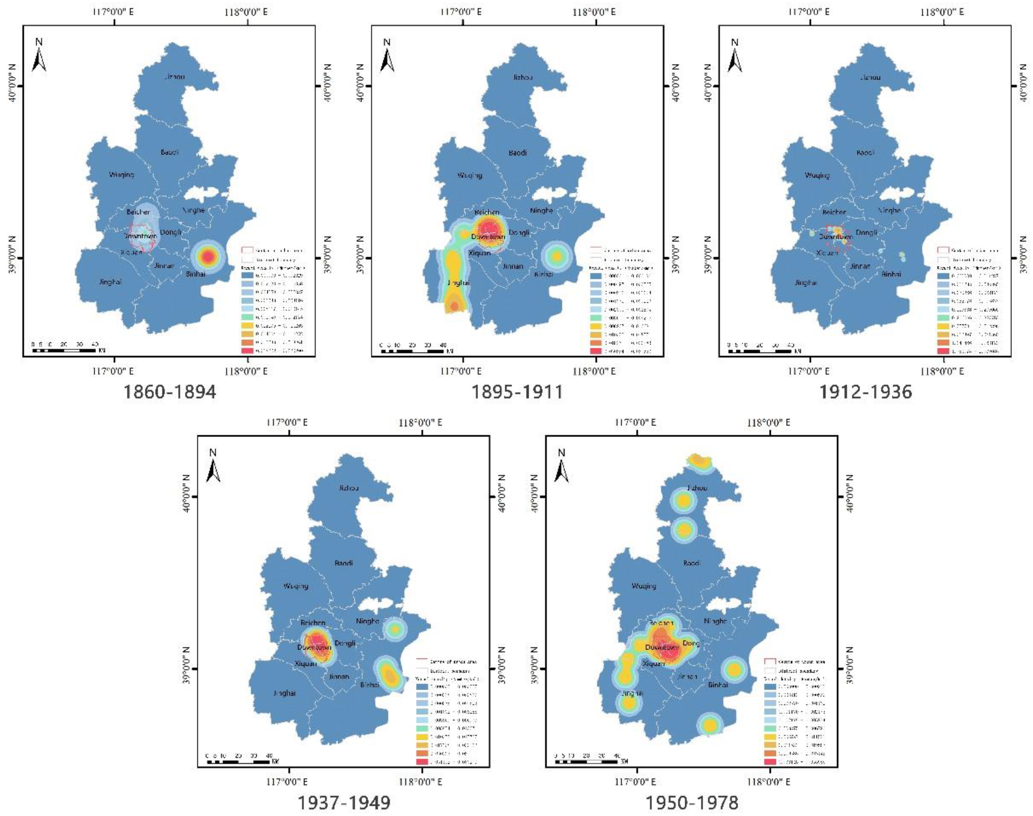
Figure 3. Kernel Density Distribution of Tianjin's Industrial Heritage by Historical Periods.
Preprints 116431 g003
Figure 4. (a) Standard deviation ellipse and (b) center of gravity migration across different time periods.
Preprints 116431 g004
Figure 5. Regional Kernel Density Distribution of Tianjin's Industrial Heritage.
Preprints 116431 g005
Figure 6. Lorenz Curve of the Distribution of Industrial Heritage Types.
Preprints 116431 g006
Figure 7. Distribution of industrial heritage by type in the view of Tianjin districts and counties.
Preprints 116431 g007
Figure 8. Distribution of kernel densities for each type of Tianjin industrial heritage.
Preprints 116431 g008
Table 1. Distribution of Tianjin's industrial heritage in relation to the water system.
Water
system
Center of urban area Binhai New District Jinghai district Xiquan district Beichen district Dongli district Ji Zhou district Ninghe district Percentage share%
Main stream of the Haihe River 34 14 1 51.58
South and North Canals 6 10 5 1 23.16
Other water systems 22 2 25.26
Table 2. Utilizing Geographical Detectors to Analyze the Influencing Factors and Their Explanatory Power on the Spatial-Temporal Distribution Variations of Tianjin's Industrial Heritage.
Dimension Targets Evaluation indicators q-value
Natural environment Topography and geomorphology Topography, geomorphology, elevation data 0.004
Green space and water system Rivers, lakes, length of waterways, distribution of green spaces 0.018
Climatological Annual precipitation, average annual temperature 0.034
Social environment Transportation factors Roads, metro, transit, shipping 0.702
Economic factors GDP per capita 0.422
Demographic factors Total population, residential distribution 0.325
Cultural and educational factors Science, education, and culture 0.257
Policy planning factors Land use, construction land use classification 0.031
Disclaimer/Publisher’s Note: The statements, opinions and data contained in all publications are solely those of the individual author(s) and contributor(s) and not of MDPI and/or the editor(s). MDPI and/or the editor(s) disclaim responsibility for any injury to people or property resulting from any ideas, methods, instructions or products referred to in the content.
Copyright: This open access article is published under a Creative Commons CC BY 4.0 license, which permit the free download, distribution, and reuse, provided that the author and preprint are cited in any reuse.
Prerpints.org logo

Preprints.org is a free preprint server supported by MDPI in Basel, Switzerland.

Subscribe

© 2024 MDPI (Basel, Switzerland) unless otherwise stated