Preprint
Article

Conservation, Evolution and Restauration Analysis of the Vegetation and the Beach Dune System of Enebrales Beach (Huelva, Spain)

Altmetrics

Downloads

72

Views

17

Comments

0

This version is not peer-reviewed

Submitted:

30 August 2024

Posted:

02 September 2024

You are already at the latest version

Alerts
Abstract
This study investigates the evolution of the vegetation and beach dune system at Enebrales Beach in Huelva, Spain, from 2003 to 2022. Utilizing orthophotographs and advanced GIS techniques, we analyzed changes in natural surface areas, vegetation cover, and dune stability. The results demonstrate significant ecological improvements: a recovery of 25,300 m² in dunes and 7,400 m² in beach areas, and a total vegetation cover increase of nearly 10,000 m². Interventions, including reforestation with native species and the stabilization of dune ridges, have been effective in enhancing the coastal ecosystem's resilience. Additionally, the beach's carrying capacity increased, allowing for approximately 2,000 more users without compromising ecological integrity. These findings underscore the importance of continued conservation efforts and adaptive management to maintain and further improve the ecological health and sustainability of Enebrales Beach Dune.
Keywords: 
Subject: Environmental and Earth Sciences  -   Remote Sensing

1. Introduction

Coastal beach-dune systems are characterized by being highly dynamic ecosystems with a continuous interaction between biotic and abiotic elements, showing at the same time a geomorphological dynamism that is often related to changes in climate regimes. Coastal dunes are formed in the presence of an accommodation space, during periods of strong winds, availability of sediment and vegetation to fix it [1]. Once established, the dune systems present a high geomorphological dynamism closely related to the intensity of the forces that interact with them. However, since the limitation in sedimentary availability at the planetary scale is clear, the morphological behavior of the systems seems to be intimately related to the climatic variations that condition the temperature, precipitation and wind regimes at the local scale [2] and continental [1].
While it is true that anthropogenic factors have been one of the elements that have most conditioned the evolution and characterization of coastal dune systems, in some cases through practices that go back centuries [3,4], more and more studies place the presence or absence of vegetation as a nuclear factor at the same time conditioning the evolution and characterization of these environments [5], especially when it enters into symbiosis with other agents such as the wind, which acts as a transport mechanism mobilizing the sediment from the emerged beach towards the interior of the dune system. In fact, it is the vegetation that plays a key role in the construction of the dune structures, retaining the sediment and facilitating its formation, especially along the first line [6].
The presence or absence of vegetation is the factor that derives from the periods of geomorphological stability or instability of these environments [1,2,7]. However, the embryonic factors of these scenarios are dominated by the climatic conditions that involve variability in precipitation, temperature and wind regimes at a local and regional scale.
The poverty of the historical data series in this regard makes it difficult to study and analyze dune behavior and the environmental parameters that condition it [8]. In fact, this lack means that nowadays much of the existing bibliography on this subject is based on approximations and estimates, it being still complex to be able to determine empirically what is the exact relationship between climatic variations and the behavior of coastal dune systems. However, more and more studies are appearing that show a close relationship between the behavior of coastal dune fields and climate change based on the behavior of the associated vegetation [9,10,11,12].
In fact, this scenario is generating a disparity of opinions regarding how to manage these systems in the face of revegetation and fixation processes. The concern for the loss of mobile sand is resulting in a paradigm shift in the restoration of coastal dunes [7]. The most recent programs of dynamic restoration, in fact, consist of destabilizing highly vegetated dunes to convert them, again, into dynamic systems [13,14]. However, the non-linear presence between the interference of human impacts and natural factors makes it difficult in many cases to identify determining factors in the re-vegetation of the dunes, which undoubtedly has consequences for future management plans interested in mitigate the effects of climate change.
The climate exerts a direct influence on plant species. In fact, and in response to climate change, substantial phenological differences determined by existing climatic conditions have been identified depending on the geographical area [15,16]. However, to date, little is known about the influence that these changes can exert on the functioning of ecosystems such as dune systems in temperate zones [1]. In certain scenarios, visible changes have occurred from a geomorphological and biological point of view in recent decades. In the Cabrera National Park, substantial changes have been observed in the sand deposition processes [17]. Beaches of scree have been converted into sandy beaches. The vegetation cannot withstand dryness and there is an increase in Oleo Ceration alliance, and the death of junipers (Juniperus phoenicea) and boxwood (Buxus balearica) (personal observations).
Although this climatic zone has optimal conditions for the growth and proliferation of vegetation, with mild temperatures, especially in summer, and with precipitation ranging between 500 mm and 1000 mm per year, one should not take into account the variability that can exist on a planetary scale (e.g. Mediterranean, oceanic or continental area). In addition, and according to the IPCC RPC8.5 scenario, temperate zones are likely to become climatically drier areas [18,19], which could lead to a alteration in the settlement and behavior of vegetation in coastal dune systems [1,20].
Be that as it may, and even more so in ecosystems as dynamic and fragile as coastal dunes, the morphological changes and the plant communities that inhabit them are largely the reason for the management and protection measures that are being taken, usually focused on the restoration of the initial values. Since the post-glacial stage, the changes associated with these environments have basically been of natural origin. However, in the short term, these are mostly linked to human causes [1].
Understanding the processes that drive these changes is important in order to select the correct and appropriate management measures. This work aims to carry out a descriptive analysis, based on an empirical and multivariable prism, to determine the evolution dune systems in temperate zones, mainly in terms of their vegetation cover, and to evaluate the management actions carried out on the beach dune area. Human interest in coastal processes and evolution has greatly increased in recent decades due to the increment of human developments recorded in coastal areas [21] and the impacts of extreme events, such as hurricanes and storms [22,23], the effects of which are enhanced by sea level rise and other climatic change-related processes, such as the increasing height of extreme waves, or changes in the tracks, frequency and intensity of storms [24,25,26,27]. Coastal development, which is essentially linked to tourism—one of the world’s largest industries [28]—continues to increase, and some 50% of the world’s coastline is currently under pressure from excessive development [21]. In Europe, the rapid expansion of urban artificial surfaces in coastal zones during the 1990–2000 period [29] has occurred in the Mediterranean and South Atlantic areas, namely Portugal (34% increase) and Spain (18%), followed by France, Italy and Greece.
In Spain, simplest studies of this nature are based on multiparametric analysis of different periods, such as the one conducted on the beach-dune systems of the Costa Brava (Girona) between 1956 and 2012 [30]. In Catalonia, the evolution of the Ebro Delta has also been studied in detail through work based on the use of GPS and LIDAR on the ground, aiming to reconstruct the evolution of the surface and the variation of dune volume between 2004 and 2012 [31]. In Asturias, the Salinas-El Espartal dune complex stands out as it was once the most extensive in Asturias and one of the largest in the Cantabrian region. Various studies have been conducted on this ecosystem using orthophotography and field measurements, which have allowed for the analysis of its evolution from the mid-20th century to 2012 [32,33,34]. In Andalusia [35] the characterization and evolution of dune systems along the Mediterranean coast, in the South of Spain, a first step to assess their relevant value in coastal flood protection and in the determination of sound management strategies to protect such valuable ecological systems are done. These studies reveal that the observed changes in the dune system are primarily due to alterations in coastal dynamics caused by constant dredging of the estuary, the construction of the promenade, and the urbanization of the surrounding area.
The use of advanced Geographic Information System (GIS) techniques allows for improved analysis of the evolution of dune fronts. In Galicia, the Digital Shoreline Analysis System (DSAS) software (USGS, 2023) has been applied to orthography to study the evolution of the dunes in the Cíes Islands between 1956 and the 2021, noting retreats of more than 30 meters of the dune front [36]. This is similar to the recent study on the evolution of the coast of Menorca from 1956 to 2021 [37,38]. The application of LIDAR and photogrammetry has also been fundamental in understanding the historical evolution of the dune system of Guardamar del Segura (Alicante), allowing for the development of a model used to assess the effectiveness of anthropic restoration actions carried out during the period 2001 to 2017, which have resulted in a significant reduction in beach size [39]. The fragility of these dune systems necessitates a detailed study of the evolution of any intervention, as observed in the protection work done on the Leirosa dunes in Figueira da Foz (Portugal) over a decade [40].
Using GIS techniques, the evolution of dune systems can be studied even in complex environments such as Cape Cod (United States), one of the places in the world with the highest number of thermal blowouts (powerful wind systems that occur in certain coastal areas and cause severe storms). Thus, through aerial photography and LIDAR, it is possible to determine the erosions produced and their connection to changes in land use [41]. All these studies highlight the enormous potential of GIS techniques, which allow extracting information from both old and recent aerial photographs.
In this regard, some studies exist for the study area, such as the descriptive study on the flora and vegetation of the area [42] or the conservation program for the coastal junipers in Andalusia [43], all of which are general in nature and do not perform an analysis of their evolution or GIS studies. Therefore, a detailed study and analysis of the evolution before and after the interventions carried out in the area is necessary; these interventions focused mainly on the regeneration of the dune system through the installation of sand-trapping devices, the recovery of the vegetation cover by planting native species typical of dune ecosystems and limiting excessive visitor pressure in the most fragile areas [44].
The aim of this research is to study the evolution of the dune system, the usable beach area, and the vegetation surface in the Enebrales area, as well as to analyze their changes between 2003 and 2022. To achieve this, data from available open sources, including aerial photography and orthophotography, will be used, particularly those accessible through the National Geographic Institute (IGN) [45].
Dune systems are multifunctional ecosystems of great importance that are fundamental for ecological balance and biodiversity. In coastal dunes, there is a close interrelationship between sand, wind, and vegetation, playing an important role in the protection and conservation of coastal fronts. However, these ecosystems are characterized by their constant dynamism and fragility [46]. The greatest threat to their survival is overexploitation, urban expansion, mining, pollution, and tourism [47], and in Punta Umbria, tourist pressure has increased considerably in recent years.
Therefore, we are dealing with a tourist municipality where urban pressure is enormous, and at the same time, we find an area of great ecological and landscape richness. It is important to have information about the vegetation of this space and its location since we find such important and endangered species as the coastal juniper (Juniperus oxycedrus subsp. macrocarpa) and the fleshy thyme (Thymus carnousus). Finally, we must not forget the ecological and socioeconomic functions that this Natural Area fulfills in such an environment, which make its conservation so important. The juniper forests are potential habitats for numerous species, some as scarce as the chameleon. Additionally, they provide seeds that are a very important food source within the coastal trophic chain, serving as food for numerous species of mammals and birds. Furthermore, these coastal forests protect the inner areas from storms, helping in the fight against beach erosion. They are also recreational and leisure areas and are ideal from an environmental education perspective.
Additionally, the dunes are protected environments by Law 2/2013 (BOE, 2013), whose dynamic nature makes the study of their evolution over the years necessary. The Enebrales de Punta Umbría Natural Area was declared as such on July 18, 1989, through Law 2/1989, which approves the inventory of Natural Spaces of Andalusia (BOJA No. 60, dated 07/27/1989). It is a transitional marine-continental dune ecosystem where the most characteristic feature is the juniper forest, a rare formation on the Andalusian coast.

2. Study Área

2.1. General Characterizaion

The study area is situated on the western coast of Huelva in southern Spain (Figure 1A,B) precisely within the municipal boundaries of Punta Umbría, and it extends across a wide sandy beach. This coastal region is bordered by the municipalities of Huelva to the north and west and Palos de la Frontera to the southeast. The beach, measuring approximately 2,600 meters in length and with an average width of 30 meters, forms an integral part of the Enebrales Natural Area (Figure 1C), which is renowned for its ecological and environmental significance.
The beach (Playa) de los Enebrales is safeguarded under the Natura 2000 Network, designated as a Site of Community Importance (SCI) with the code ES6150002 (Enebrales de Punta Umbría) [48]. This protection encompasses an area of 187.57 hectares (Figure 2), emphasizing the region's critical role in preserving biodiversity at the European level (European Commission, 2023). In addition, the area is legally protected as a Natural Area under Law 2/1989, of July 18, which sanctioned the Inventory of Protected Natural Spaces of Andalusia and established further protective measures (BOJA No. 60, July 27, 1989). These legal frameworks aim to ensure the conservation of the area's unique ecological characteristics, safeguarding it against potential environmental threats.

2.2. Geological and Ecological Characteristics

The Enebrales de Punta Umbría is characterized by a recently formed sandy deposit of marine aeolian origin, which contributes to the formation of the Punta Umbría sandy spit. This geological formation is significant for its rarity along the Andalusian coast, hosting a mixed forest primarily composed of junipers (Juniperus oxycedrus macrocarpa) and savins (Juniperus phoenicea), species that are uncommon in this region [49]. These plant communities are not only of ecological importance but also contribute to the stabilization of the dune systems, which are crucial for coastal protection and ecosystem stability.
The coastal ecosystem within the Enebrales Natural Area exhibits a distinct dune morphology, featuring ancient, stabilized dunes that form two parallel ridges aligned with the coastline. The seaward side is characterized by an embryonic dune ridge, while the internal ridge is more stabilized, displaying early stages of soil development. This unique dune system plays a critical role in coastal dynamics, acting as a natural barrier against erosion and providing a habitat for specialized plant and animal species [50].

2.3. Biodiversity and Faunal Importance

The area is a biodiversity hotspot, particularly for avian species, as it serves as a crucial habitat for numerous seabirds and waders during migratory passages and wintering periods. The presence of a colony of approximately 50 pairs of Little Terns (Sterna albifrons) underscores the importance of the region for bird conservation [51]. Additionally, the area supports raptors such as the osprey (Pandion haliaetus), which is reported to nest near this area [52]. The diverse fauna also includes several reptile species, notably the Large Psammodromus (Psammodromus algirus), the Ocellated Lizard (Timon lepidus), and the Chameleon (Chamaeleo chamaeleon), further highlighting the ecological value of the area [53].

2.4. Restauration

The main objective was to restore the dune system on Los Enebrales beach to prevent and/or reduce the process of degradation of the dune system and the recovery of the plant cover of said system and the consequent approach to its ecological balance. For this reason, this project contemplated the adaptation of the existing infrastructures and services towards a sustainable use, balancing the use and enjoyment of the beach by users without the loss of its ecological values.
In general terms, the project is made up of various actions to guarantee the stability of the dune cordon in the short, medium and long term, and they consist fundamentally of controlling and promoting the recovery of the plant cover and thus, its fixation, understood as the dynamic balance of the system.
The main action of the project was the regeneration of the dune system by means of the installation of sand-catching devices, the recovery of the plant cover, by planting native species typical of dune ecosystems and limiting the excessive pressure of visitors in the most fragile areas.

2.5. Restoration Work Carried Out

Installation of passive sand collectors made of biodegradable materials. Planting of sand-fixing dune species: sand bar (Ammophila arenaria) and sea grass (Elymus farctus), mainly. Adjustment by means of walkways, of the pedestrian accesses over the dunes to the beach, from the place where the existing walkways end. Remodelling of the dune profile by adding sand in places where the connection of the existing walkways with the new walkways proposed to cross the dunes requires it. Installation of protective fencing in planted areas and in areas that, although not planted, need to limit the influx of visitors. Elimination of invasive species such as cat's claw (Carpobrotus edulis). Cleaning and removal of waste and finally signage of the area.
The restoration work was completed in 2008 and an evaluation of the work has now been carried out.

3. Materials and Methods

Orthophotographs are high-resolution images obtained through photogrammetric flights that have been rectified to conform to the terrain's shapes. They are offered as a downloadable product where all elements are at the same scale, free from errors and distortions, and correctly georeferenced. For the study region, we have orthophotos from the historical series of the National Plan for Aerial Orthophotography (PNOA) for the year 2022 and from SIGPAC for 2003 [45]. These images are available in GeoTIFF format in the ETRS89 reference system, divided into 2x2 km² sheets at a 1:50,000 scale. The spatial resolution has varied over time, being at least 25 cm since 2017. These images were used to identify the interface between vegetated and non-vegetated dunes, the vegetation of the forest, and the types of vegetation present.
These orthophotographs will be processed using GIS software to define and analyze the state of vegetation, the dune front, the beach surface, and their evolution with a detail level of 1 meter. The selected orthophotographs correspond to the years before the interventions carried out in 2007/2008 and 15 years later in 2022, to observe the real changes in the study area.
Additionally, the beach's carrying capacity and its evolution will be calculated based on the usable surface area. The measurements of the usable beach surface are derived from orthophotographs from 2003 and 2022. However, it must be considered that the beach surface varies according to coastal dynamics. After storms, parts of the beach often erode and change their surface area. The following premises were taken into account, in delineating the coastline, the upper limit of the swash zone—the maximum reach of the wave on the dry beach—was considered appropriate [54,55,56,57]. This mark or limit is visible in both color and black-and-white aerial photographs and is easily recognizable along the coastline [57].
Furthermore, the user density guidelines from Menorca beaches were followed, where the density is 5 m²/user for urban beaches and 15 m²/user for virgin or natural beaches. Therefore, a factor of 5 m²/user, 10 m²/user, or 15 m²/user was applied according to the naturalness of the beaches where the interventions were conducted [58].
On the other hand, we have conducted a study of the population that has benefited from the interventions as a socioeconomic indicator. Thus, the benefited population is those who, directly or indirectly, will receive a benefit from the project, whether it be environmental, economic, landscape-related, or recreational. The directly benefited population also includes those who are directly affected by the project. These are the municipalities that will be affected in one way or another by the project to be carried out in the study area.
Additionally, we must consider the transient population (tourism) in the area. Due to the lack of more detailed data, we have calculated this based on accommodation capacity (Hotels, Hostels, apartments, campsites, rental platforms i.e. Airbnb). The territory, which serves as the stage for tourist activities, hosts a variable volume of tourists, referred to as the tourist load of the territory. Although direct statistical information on tourist load is not always available, especially when we examine it at a municipal or microspatial level. Therefore, when we approach the study at this territorial scale, we encounter a lack of official statistics. In such circumstances, it is necessary to estimate the volume of tourists, or what we call the tourist load. We calculate this based on the accommodation capacity of the area in question and apply a weighting factor consistent with the approximate average of the location. In this way, we assume there are four months of high season and eight months of low season. During the low season, the area has an average occupancy rate of between 70% and 80%, with an average stay of 2 weeks, which totals 32 weeks, with turnover every two weeks. The four months of high season have 100% occupancy, 30 days a month, with an average stay of one to two weeks. Therefore, the total beneficiary population is the resident population (data from the Spanish National Institute of Statistics for 2022) plus the transient population.

4. Results

4.1. Recovered Natural and Vegetation Surface Area

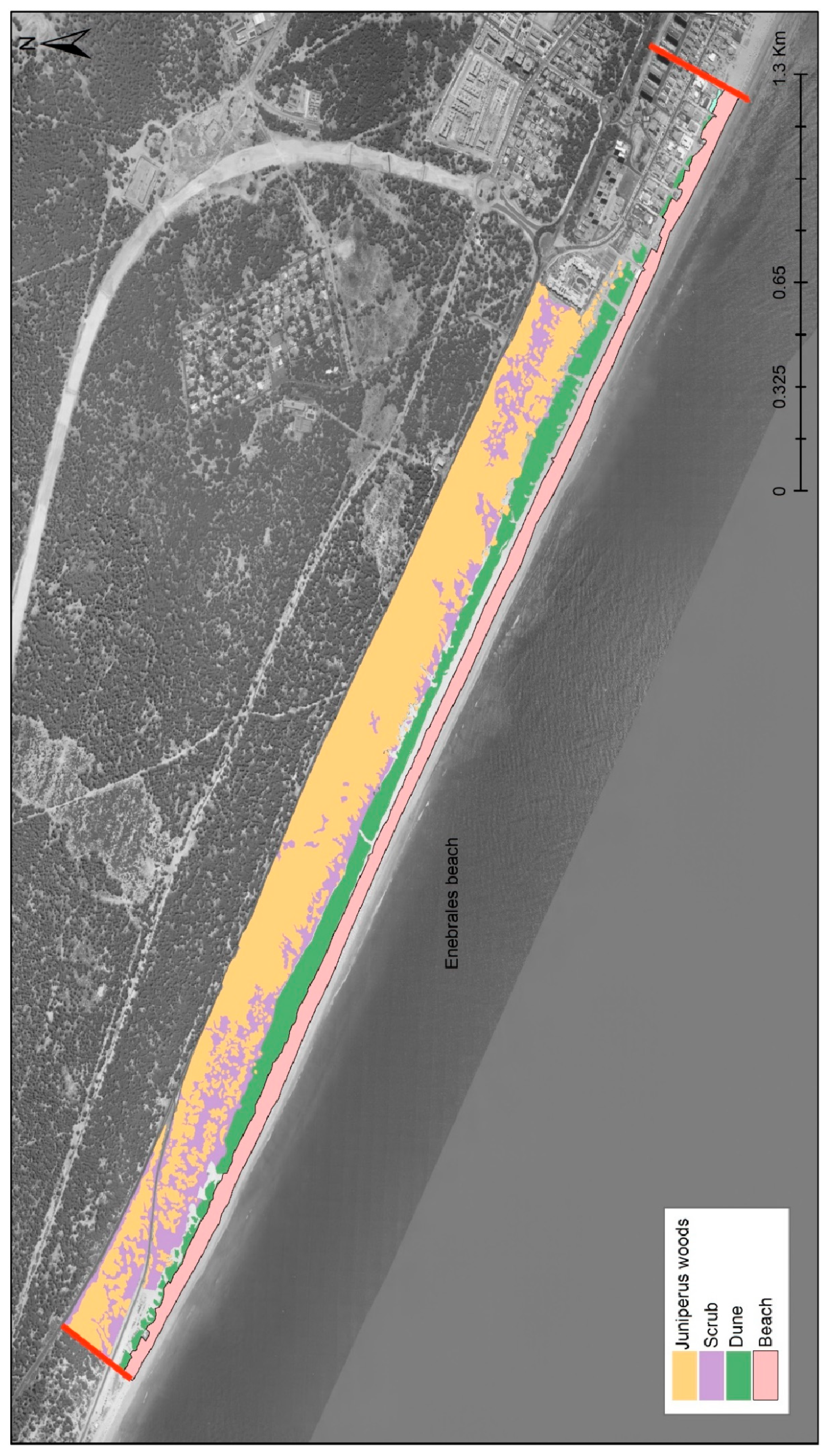
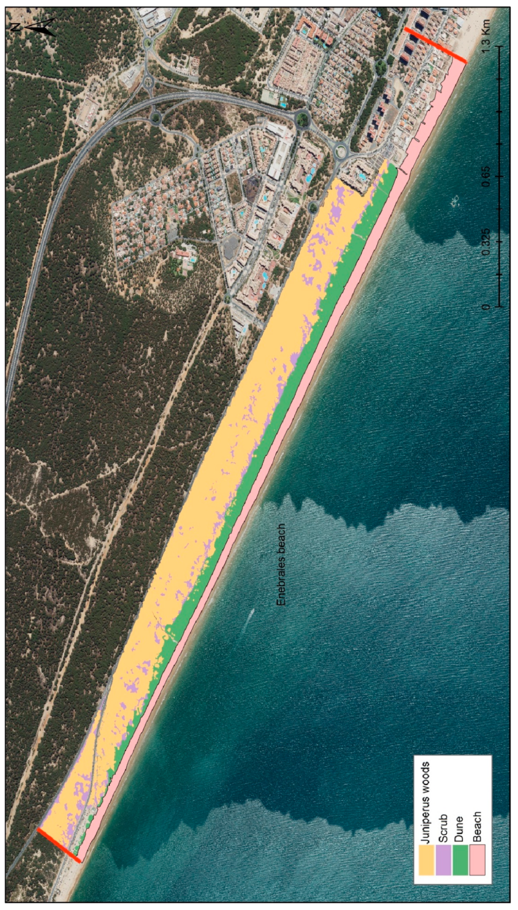
In general, from 2003 to 2022, the natural surface area has recovered approximately 25,300 m² of dunes and 7,400 m² of beach (Table 1). This indicates that the soft interventions carried out have been beneficial in terms of increasing the natural surface area.
The vegetation map resulting from the analysis of the 2003 orthophotograph shows that most of the territory was occupied by dense pine forests or pine-scrubland, with some areas of bare soil with sparse scrub. Despite the area being primarily part of a juniper vegetation series (Osyris quadripartitae, Juniperetum turbinatae), the old reforestation with stone pine (Pinus pinea) left this formation relic in certain areas. In the scrubland area, two zones could be distinguished: the zone closer to the coast, where the stabilization of the mobile beach dune began, and the inland scrubland corresponding to serial stages of juniper degradation. The surface analysis reveals that, overall, vegetation has increased. The forest of pine, juniper, and savin increased by approximately 70,226 m² from 2003 to 2022. Although the scrubland area decreased by 60,795 m², the total vegetation surface increased by nearly 10,000 m². This means that part of the area previously colonized by scrub has transitioned to forest. This increase is due to the planting of these species, the protection of the dune ridge, and the limitation of beachgoers to designated beach entry areas, preventing passage through the forest and the creation of new routes or trails. This restriction has concentrated beachgoers in authorized entry and passage zones. Consequently, the juniper, a protected and endangered species, is in good conservation status, with a considerable increase in its surface area, in parallel that fact improved the habitat of the fauna present in the area such as the Little Terns or the Chameleon.

4.2. Evolution of the Coastal Dune

The coastal dune in the intervention area of Enebrales de Punta Umbría shows favorable evolution from 2003 to 2022. According to the analysis of the 2003 and 2022 orthophotographs, the dune area increased by 25,288 m², or 16.2% (see Figure 2 and Figure 3 and Table 1). Therefore, the intervention results have been highly favorable.

4.3. Beach Carrying Capacity

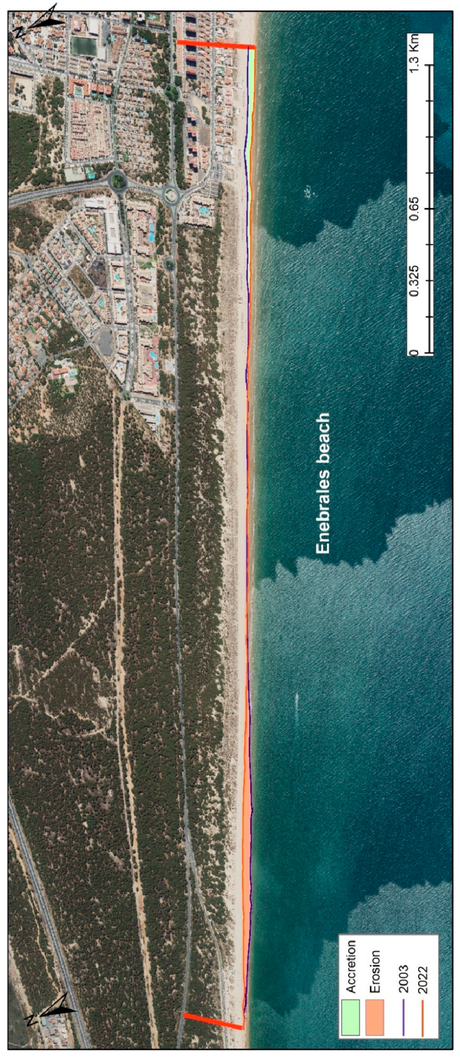
After calculating the usable beach surface area for 2003 and 2022, we observe that the total usable surface area increased from 151,994 m² in 2003 to 159,386 m² in 2022. This slight increase of 7,392 m² in beach surface area corresponds to an increase in carrying capacity (density m²/users) from 30,399 in 2003 to 31,878 users in 2022. Table 2 and Figure 4 shows the surface area and the maximum number of users that can be accommodated simultaneously, depending on whether it is an urban area (5 m²/user) or a natural area (15 m²/user). The carrying capacity has increased by about 2,000 more users.

4.4. Number of Inhabitants Benefited by the Interventions

In 2023, Punta Umbría had a population of 16,069 inhabitants, while the province of Huelva reached a total of 530,824 people. The population has shown a steady increase over the years. Specifically, from 2000 to 2023, the population of Punta Umbría grew by 4,082 people, and across the province of Huelva, from 1996 to 2023, there was an increase of 76,089 people, representing a growth of 14.33% [59].
Regarding the calculation of the floating population due to tourism, this has been estimated based on the accommodation capacity in the study area. This capacity is interpreted as the total available spots (PTa), which amounts to 7,719 people. Additionally, spots from rentals through platforms like Airbnb [60] contribute approximately 956 spots. Thus, the total available spots (PT) are:
PT = PTa + PTb = 7,719 + 956 = 8,675 places.
The analysis is divided into 12 months, with 4 months corresponding to the high season, averaging 30 days per month. For the low season (8 months), an 80% occupancy rate is estimated over 30 days, with an average stay of 2 weeks (excluding Easter and Christmas). This represents 32 weeks, with new guests every two weeks:
Tb = (PT * 0.8) * 16 = 6,940 * 16 = 111,040 people.
During the high season (4 months), a 100% occupancy rate is assumed over 30 days, with an average stay of 1 to 2 weeks, resulting in:
Ta = (PT * 1) * 16 = 7,719 * 16 = 123,504 people.
The total tourist load (CT) is calculated as:
CT = CT_tb (PT * 0.8) + CT_ta (PT * 1) = 234,544 people.
In total, the population benefiting from these activities consists of the resident population (530,824 people) plus the floating population (tourist load) (234,544 people), amounting to a total of 765,368 people benefiting. If we only consider the residents of Punta Umbría (16,069 people) along with their floating population (234,544 people), the total comes to 250,613 people. These figures indicate a moderate pressure on the study area, with an annual floating population of approximately 250,613 people.
Currently, the usable beach area has increased, which has raised its carrying capacity to 31,878 spots. If we subtract the resident population (16,069 people), 15,809 spots remain available. Even on a peak day during the high season, with a maximum estimated occupancy of 24,744 people, the carrying capacity of the area (31,878 spots) would not be exceeded.
Pmax = PT + Presi = 8,675 spots + 16,069 spots = 24,744 people.

5. Discussion

The study of the evolution of the vegetation and beach dune system of Enebrales Beach in Huelva, Spain, has provided valuable insights into the dynamic nature and resilience of this coastal ecosystem. By analyzing orthophotographs from 2003 and 2022, we have observed significant changes in both the natural surface area and vegetation cover, as well as improvements in the dune system and beach carrying capacity.
Recovery of Natural Surface Area: the interventions implemented between 2003 and 2022 have resulted in a substantial recovery of natural surface areas, with an increase of approximately 25,300 m² in dunes and 7,400 m² in beach surface area. This indicates the effectiveness of the restoration efforts in promoting the natural regeneration of these critical habitats.
Vegetation Cover: the total vegetation cover has increased by nearly 10,000 m². This growth is primarily due to the successful reforestation with native species, the protection of the dune ridge, and the restriction of beachgoers to designated entry areas, which has prevented further degradation. Notably, the forest of pine, juniper, and savin has expanded by approximately 70,226 m², while the scrubland area has decreased by 60,795 m², indicating a transition from scrubland to forested areas and the forest are increased in approximately 10.000 m2.Dune System Evolution: the coastal dune system has shown a favorable evolution, with a significant increase in dune area by 25,288 m² (16.2%) from 2003 to 2022. This positive change underscores the success of the interventions aimed at stabilizing and restoring the dune ecosystem.
Beach Carrying Capacity: the usable beach surface area has increased from 151,994 m² in 2003 to 159,386 m² in 2022. Consequently, the beach’s carrying capacity has improved, allowing for approximately 2,000 more users. This enhancement in carrying capacity reflects a better-managed beach environment that can accommodate more visitors without compromising its ecological integrity.
Inhabitants benefited by the interventions: The data presented highlights the significant role of tourism in Punta Umbría and the broader Huelva region. Over recent decades, both areas have experienced notable population growth, with Punta Umbría showing a steady increase in residents and Huelva demonstrating a broader demographic expansion. The analysis of the floating population, particularly driven by tourism, underscores the importance of managing the region's carrying capacity. Despite the considerable influx of tourists, especially during the high season, the current infrastructure and expanded beach area in Punta Umbría are capable of accommodating this demand without exceeding the area's carrying capacity. This balance between resident and tourist populations suggests a well-managed environment that supports both local communities and the tourism sector, ensuring sustainable growth and development in the region. The findings indicate that, while there is moderate pressure from tourism, the existing capacity remains sufficient, providing a positive outlook for the continued coexistence of residents and visitors. The soft management measures of dune systems are essential for their conservation [61].
Finally, the successful recovery and enhancement of the vegetation and dune systems at Enebrales Beach demonstrates the positive outcomes of targeted conservation interventions. These efforts not only preserve the ecological and landscape richness of the area but also enhance its capacity to support both biodiversity and sustainable tourism. Continued dedication to monitoring, managing, and restoring this valuable coastal ecosystem will be essential for its future resilience and health.

Acknowledgments

This work is cofinanced by Centro de Estudios y Experimentación de Obras Públicas (CEDEX) with the support of the Societat d’Història Natural de les Balears (Natural History Society of the Baleric Islands). This work also contributes to the research project: “Chronic Emergencies and Ecosocial Transformations in Touristic Coastal Areas (PID2022-137648OB-C21), funded by MCIN/AEI/ 10.13039/501100011033 and by “FEDER A way of making Europe”.

References

  1. Provoost, S.; Laurence Jones, M.; Edmolson, S. E. Changes in landscape and vegetation of coastal dunes in northwest Europe: a review. J. Coast. Conserv., 2011, 15: 207-226. [CrossRef]
  2. Jackson, D.W.T.; Cooper, J.A.G. Coastal dune fields in Ireland: rapid regional response to climatic change. Journal of Coastal Research, 2011, SI64: 293-297.
  3. Roig-Munar, F.X.; Fraga, P.; Martín-Prieto, J.A.; Pons, G.X.; Rodríguez-Perea, A. Fixació i estabilització de sistemes dunars a les Illes Balears per processos de forestació: el cas de Menorca. Boll. Soc. Hist. Nat. Balears, 2009, 52: 129-140.
  4. Mir-Gual, M.; Fraga, P.; Pons, G.X.; Roig-Munar, F.X.; Martín-Prieto, J.A.; Rodríguez-Perea, A.; Brunet, P. Alteracions antròpiques en els boscos de Pinus halepensis Mill. dels sistemes dunars de Mallorca. Boll. Soc. Hist. Nat. Balears, 2010, 53: 133-152.
  5. Martínez, M.L.; Pérez-Maqueo, O.; Vázquez, G.; Landgrave, R. Warmer temperature and spatiotemporal dynamics during primary succession on tropical coastal dunes. Plants, 2022, 11(22), 3029.
  6. Mir-Gual, M. Anàlisi, caracterització i dinàmica de les formes erosives blowout en sistemes dunars de Mallorca i Menorca (Illes Balears). PhD. 2014. Universitat de les Illes Balears.
  7. Delgado-Fernández, I.; Mir-Gual, M. Incremento de la cobertura vegetal en las dunas de Sefton, NO de Inglaterra. Geo-Temas, 2015, 15: 9-12.
  8. Aagaard, T.; Orford, J.; Murray, A.S. Environmental controls on coastal dune formation; Skallingen Spit, Denmark. Geomorphology, 2007, 83: 29-47.
  9. Van der Maarel, E. Dry coastal ecosistems. In: Ecosystems of the World. Elsevier. 1993. Amsterdam. 600 pp.
  10. Hugenholtz, C.H.; Wolfe, S.A. Recent stabilization of active sand dunes on the Canadian prairies and relation to recent climate variations. Geomorphology, 2005, 68: 136-147.
  11. Tsoar, H.; Levin, N.; Porat, N.; Maia, L.P.; Herrmann, H.J.; Tatumi, S.H.; Claudino-Sales, V. The effect of climate change on the mobility and stability on coastal sand dunes in Ceará State (NE Brazil). Quat. Res., 2009, 71: 217-226.
  12. Ajedegba, J.O.; Perotto-Baldivieso, H.L.; Jones, K.D. Coastal dune vegetation resilience on South Padre island, Texas: a spatiotemporal evaluation of the landscape structure. Journal of Coastal Research, 2019, 35: 534-544.
  13. Darke, I.B.; Eamer, J.B.R.; Beaugrand, H.E.R.; Walker, J. Monitoring considerations for a dynamic dune restoration project: Pacific Rim National Park Reserve, British Columbia, Canada. Earth Surf. Process. Landforms, 2013, 38: 983-993.
  14. Pye, K.; Blott, S.J.; Howe, M.A. Coastal dune stabilization in Wales and requirements for rejuvenation. Journal of Coastal Research, 2014, 18: 27-54.
  15. Berry, P.M.; Dawson, T.P.; Harrison, P.A.; Pearson, R.G. Modelling potential impacts of climate change on the bioclimàtic envelope of species in Britain and Ireland. Global Ecol. Biogeogr., 2002, 11: 453-462.
  16. Root, T.L.; Price, J.T.; Hall, K.R.; Schneider, S.H.; Rosenzweig, C.; Pounds, J.A. Fingerprints of global warming on wild animals and plants. Nature, 2003, 421: 57-60.
  17. Servera-Nicolau, J.; Pons, G.X.; Del Valle, L. Descripción geomorfológica de los sistemas deposicionales en la línea de costa de la isla de Cabrera (Parque Nacional Marítimo Terrestre del Archipiélago de Cabrera, Islas Baleares) 2024. Libro de actas XII Jornadas de Geomorfología Litoral.
  18. Rubel, F., Brugger, K., Haslinger, K.; Auer, I. The climate of the european Alps: shift of very high resolution Köppen-Geiger climate zones 1800-2100. Meteorologische Zeitschrift, 2017, 26: 115-125.
  19. Beck, H.; Zimmermann, N.; McVicar, T. Noemi Vergopolan, N.; Berg, A.; Wood, E.F. Present and future Köppen-Geiger climate classification maps at 1-km resolution. Sci. Data, 2018, 5: 180-214.
  20. Mir-Gual, M.; Pons, G.X. Comparativa ambiental i climàtica de sistemes dunars costaners de la zona temperada. Boll. Soc. Hist. Nat. Balears, 2023, 66: 197-212.
  21. Finkl, C.W.; Kruempel, C. Threats, obstacles and barriers to coastal environmental conservation: Societal perceptions and managerial positionalities that defeat sustainable development. In Proceedings of the First International Conference on Coastal Conservation and Management in the Atlantic and Mediterranean, Algarve, Portugal, 17–20 April 2005; pp. 3–28.
  22. Meyer-Arendt, K.J. Grand Isle, Louisiana: A historic US Gulf Coast resort adapts to hurricanes, subsidence and sea level rise. In Disappearing Destinations: Climate Change and Future Challenges for Coastal Tourism; Jones, A., Phillips, M., Eds.; CAB International: Wallingford, UK, 2011; pp. 203–217, ISBN 978-1-84593-548-1.
  23. Anfuso, G.; Loureiro, C.; Taaouati, M.; Smyth, T.A.G.; Jackson, D.W.T. Spatial variability of beach impact from post-tropical cyclone Katia (2011) on Northern Ireland’s North coast. Water 2020, 12, 1380.
  24. ones, A.; Phillips, M. Disappearing Destinations: Climate Change and Future Challenges for Coastal Tourism; CAB International: Wallingford, UK, 2011; ISBN 978-1-84593-548-1.
  25. Cid, A.; Menéndez, M.; Castanedo, S.; Abascal, A.J.; Méndez, F.J.; Medina, R. Long-term changes in the frequency, intensity and duration of extreme storm surge events in southern Europe. Clim. Dyn. 2016, 46, 1503–1516. [Google Scholar] [CrossRef]
  26. Nguyen, T.T.X.; Bonetti, J.; Rogers, K.; Woodroffe, D. Indicator-based assessment of climate-change impacts on coasts: A review of concepts, methodogical approaches and vulnerability indices. Ocean Coast. Manag., 2006, 123, 18–43. [Google Scholar] [CrossRef]
  27. Wolf, J.; Woolf, D.; Bricheno, L. Impacts of climate change on storms and waves relevant to the coastal and marine environment around the UK. MCCIP Sci. Rev. 2020, 132–157. [Google Scholar]
  28. Klein, Y.L.; Osleeb, J.P.; Viola, M.R. Tourism-generated earnings in the coastal zone: A regional analysis. J. Coast. Res., 2004, 20, 1080–1088. [Google Scholar]
  29. European Environmental Agency. The Changing Faces of Europe’s Coastal Areas; Office for Official Publications of the European Communities: Bruxelles, Belgium, 2006. [Google Scholar]
  30. Roig-Munar, F.X.; Vicens, J.; Mir-Gual, M.; Martín-Prieto, J.A.; Pons, G.X. 2013. Evolución espacio temporal (1956-2012) de los sistemas dunares del Baix y Alt Empordà (Girona, Cataluña). Geo-Temas, 2013, 14, (VII Jornadas de Geomorfología litoral), 99-102.
  31. Rodríguez-Santalla, I.; Gómez-Ortiz, D.; Martín-Crespo, T.; Sánchez-García, M.J.; Montoya-Montes, I.; Martín-Velázquez, S.; Barrio, F.; Serra, J.; Ramírez-Cuesta, J.M.; Gracia, F.J. Study and Evolution of the Dune Field of La Banya Spit in Ebro Delta (Spain) Using LiDAR Data and GPR. Remote Sensing, 2021, 13, 802. [Google Scholar] [CrossRef]
  32. López-Peláez, J.; Flor-Rodríguez, G. Evolución ambiental del estuario de Avilés (1833-2006). Trabajos de Geología, 2008, 135, 119–135. [Google Scholar]
  33. Flor-Blanco, G.; Flor, G.; Pando, L. Evolution of the Salinas-El Espartal and Xagó beach/dune systems in north-western Spain over recent decades: Evidence for responses to natural processes and anthropogenic interventions. Geo-Marine Letters, 2013, 33, 143–157. [Google Scholar] [CrossRef]
  34. Flores-Soriano, C. Evolución de los campos dunares de Asturias desde mediados del Siglo XX hasta 2014. 2015.
  35. Molina, R.; Manno, G.; Lo Re, C.; Anfuso, G. Dune Systems’ Characterization and Evolution in the Andalusia Mediterranean Coast (Spain). Water, 2020, 12, 2094. [Google Scholar] [CrossRef]
  36. Gómez-Pazo, A.; Pérez-Alberti, A.; Pérez, X.L.O. Recent Evolution (1956–2017) of Rodas Beach on the Cíes Islands, Galicia, NW Spain. Journal of Marine Science and Engineering, 2019, 7, 125. [Google Scholar] [CrossRef]
  37. Martín-Prieto, J.A.; Pons, G. X; Carreras, D. Evolución histórica de costa de playas de Menorca (Illes Balears): 1956-2021, 2021. UIB -OBSAM-IME. Societat d’Història Natural de les Balears. 59 pp. https://drive.google.com/file/d/1_s1tiFe7STMwHSuKT1TCi0i98pUiqm5g/view?rm=minimal.
  38. Martín-Prieto, J.A.; Carreras, D.; Pons, G.X.; Almaraz, A. Shoreline historical evolution (1956-2015) of beaches of Menorca (Balearic Islands). In: Malvárez, G. and Navas, F. (eds.), Global Coastal Issues of 2020. J. Coast. Res., 2020. Special Issue No. 95, pp. 563–567. Coconut Creek (Florida).
  39. Pagán, J.I.; Bañón, L.; López, I.; Bañón, C.; Aragonés, L. Monitoring the dune-beach system of Guardamar del Segura (Spain) using UAV, SfM and GIS techniques. Science of the Total Environment, 2019, 687, 1034–1045. [Google Scholar] [CrossRef] [PubMed]
  40. Do Carmo, J.A.; Reis, C.S.; Freitas, H. Working with Nature by Protecting Sand Dunes: Lessons Learned. J. Coast. Res., 2010. 26, 1068-1078. [CrossRef]
  41. Abhar, K.C.; Walker, I.J.; Hesp, P.A.; Gares, P.A. Spatial-temporal evolution of aeolian blowout dunes at cape cod. Geomorphology, 2015, 236, 148–162. [Google Scholar] [CrossRef]
  42. Andivia, E.; Hidalgo, P.J.; López-Albacete, I.; De las Heras, M.A. Flora y Vegetación del paraje natural de los Enebrales de Punta Umbría (Huelva). 2006. https://pfcyl.es/sites/default/files/eventos/adjuntos/98.pdf Accessed 02 Jan 2024.
  43. Redondo, I.; Saavedra, C. Programa de conservación de Enebrales costeros en Andalucía. 2006. https://pfcyl.es/sites/default/files/eventos/adjuntos/65.pdf Accessed 02 Jan 2024.
  44. Cuena, G. Restauración de la Duna litoral en la Playa de los Enebrales, T.M. de Punta de Umbria (Hueva). Ecología litoral. 2004.
  45. Instituto Geográfico Nacional, 2024. Plan Nacional de Ortofotografía Aérea. https://pnoa.ign.es/web/portal/pnoa-imagen/estadode-los-vuelos. Accessed 02 Jan 2024.
  46. MITECO. Playas, arenales y sistemas dunares. 2018. https://www.miteco.gob.es/es/costas/temas/proteccion-costa/conociendolitoral/zonas-litorales-espanolas/clasificacion-tipologica/playas-arenales-sistemasdunares.aspx. Accessed 16 Jun 2023.
  47. Martínez, M.L., Maun, M.A., Psuty, N.P. 2008. The Fragility and Conservation of the World’s Coastal Dunes: Geomorphological, Ecological and Socioeconomic Perspectives. Coastal dunes: ecology and conservation, 355-369. [CrossRef]
  48. European Commission. 2023. Natura 2000 – Sites of Community Importance. Retrieved from European Commission website.
  49. Gómez Mercado, F. Flora and Vegetation of the Protected Natural Areas of Andalusia. 2011. Editorial Universidad de Granada.
  50. Martínez, M.L.; Psuty, N.P. Coastal Dunes: Ecology and Conservation. 2013. Springer.
  51. BirdLife International. 2021. Sterna albifrons species factsheet. Retrieved from BirdLife International website.
  52. López-Cortijo, A., Anejo 1: Caracterización Ambiental. Restauración de la duna litoral en la playa de los Enebrales, T.M., de Punta Umbría (Huelva). 2004. Ecología Litoral. 75 pp.
  53. Salvador, A. (Coordinador). Reptiles. 2ª edición revisada y aumentada. 2014. In: Fauna Ibérica, vol. 10. Ramos, M. A. et al. (Eds.). Museo Nacional de Ciencias Naturales. CSIC. Madrid. 1.372 pp.
  54. Ojeda, J. Método para el cálculo de la erosión costera. Revisión, tendencias y propuestas. Boletín AGE, 2000, 30: 103-118.
  55. Martín-Prieto, J. A.; Roig, F. X.; Rodríguez-Perea, A.; Pons, G. X. Evolució de la línia de costa de la platja es Trenc. 2010, In: J. Mayol, Ll. Muntaner y O. Rullán, (eds.). Homenatge a Bartomeu Barceló Pons, Geògraf. Palma, Ed. Lleonard Muntaner, 423-440.
  56. Martín-Prieto, J. A.; Roig Munar, F. X.; Rodríguez-Perea, A.; Mir-Gual, M.; Pons, G. X.; Gelabert, B. La erosión histórica de la playa de sa Ràpita (S. Mallorca). Investigaciones Geográficas, 2016, 66: 135-154. [CrossRef]
  57. Martín-Prieto, J. Á.; Carreras, D.; Pons, G.X.; Almaraz, D. Evolución histórica de la línea de costa de playas de Menorca (Illes Balears): 1956-2015. 2018, OBSAM-IME, Societat d’Història Natural de les Balears. Maó 61 pp.
  58. Pons, G.X.; Martín-Prieto, J.A.; Carreras, D. Tourist visitation and beach erosion: Analysis of the evolution of the coastline, frequentation and beach area on the island of Menorca (2001-2015) (Balearic Islands, Spain). 2023, Geographies of Tourism and Global Change, Blanco-Romero, A.; Blàzquez-Salom M. (edit.). Spanish Tourism Geographies: Territorial Diversity and Different Approaches. Springer.
  59. Instituto Nacional de Estadística., 2023. Población del Padrón Continuo por Unidad Poblacional. https://www.ine.es/nomen2/index.do?accion=busquedaAvanzada&entidad_amb=no&codProv=15&codMuni=17&codEC=0&codES=0&codNUC=0&denominacion_op=like&denominacion_txt=&L=0 Consultada el 02/6/2024.
  60. Plataform Airbnb, 2023. https://www.airbnb.es/playa-de-punta-umbria-spain/stays.
  61. Roig-Munar, F. X.; Rodríguez-Perea, A.; Martín-Prieto, J. A.; Pons, G. X. Soft Management of Beach-Dune Systems as a Tool for their Sustainability. J. Coast. Res., 2009, SI 56, 1284-1288. [CrossRef]
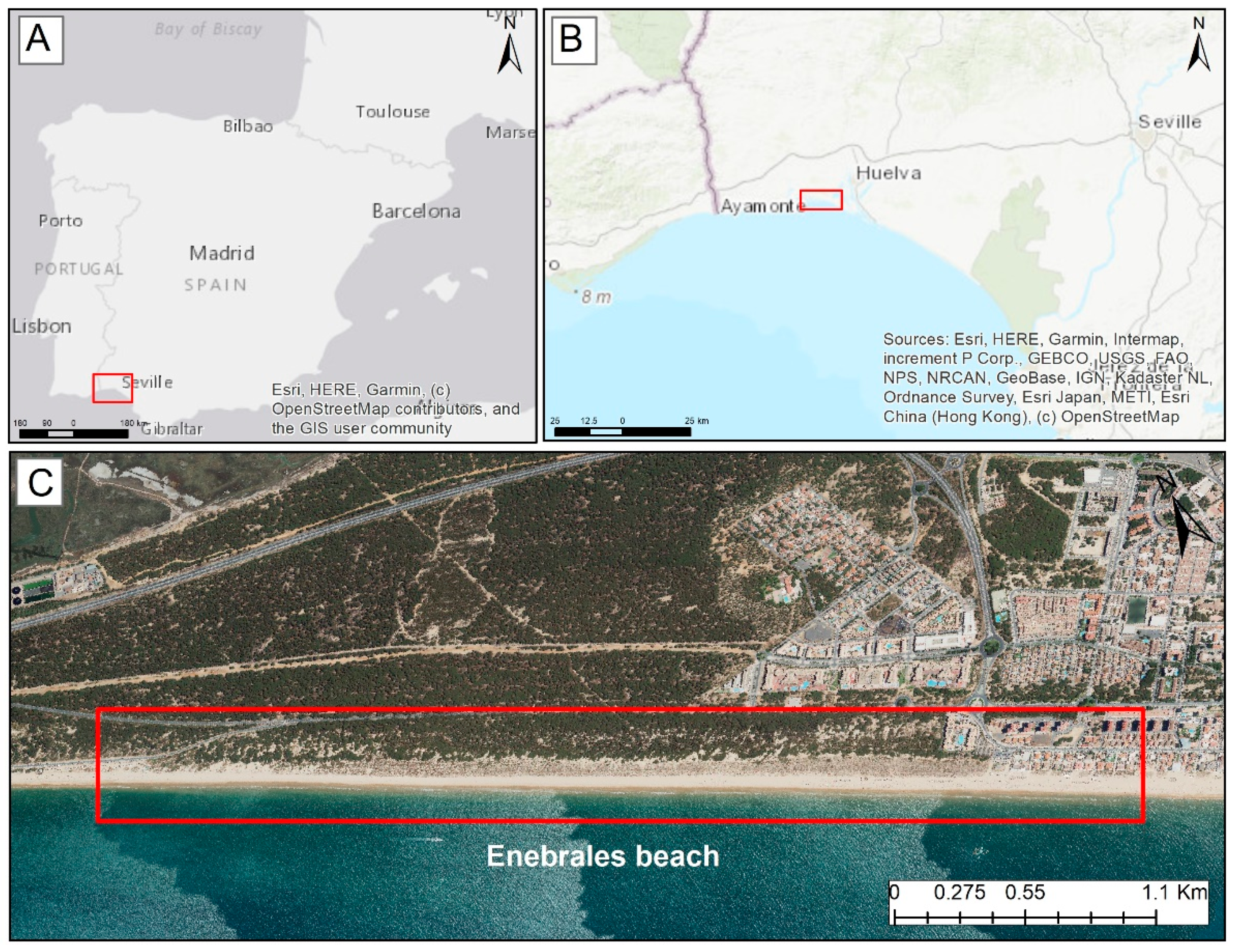
Figure 1. Location of Enebrales beach-dune.
Preprints 116748 g001
Figure 2. Map of the vegetation and Surface beach-dune of the Los Enebrales (Punta Umbría) 2003.
Preprints 116748 g002
Figure 3. Map of the vegetation and Surface beach-dune of the Los Enebrales (Punta Umbría) 2022.
Preprints 116748 g003
Figure 4. Accretion or erosion surface of the coastline of Playa de los Enebrales 2003-2022.
Preprints 116748 g004
Table 1. Table of the surface area according to the type of cover for the period 2003 to 2022.
Surface type 2003 (m2) 2022 (m2) Difference
Pine, savin and juniper forest 426382 496608 + 70226
Matorral 134304 73509 - 60795
Dune 131211 156499 + 25288
Beach 151994 159386 + 7392
Total: 843891 886002 42111
Table 2. Summary table of the useful surface area of Enebrales beach and its maximum load capacity.
Year Surface m2 Density 5 m2/user Density 15 m2/user
2003 151.994 30.399 10.133
2022 159.386 31.878 10.626
Disclaimer/Publisher’s Note: The statements, opinions and data contained in all publications are solely those of the individual author(s) and contributor(s) and not of MDPI and/or the editor(s). MDPI and/or the editor(s) disclaim responsibility for any injury to people or property resulting from any ideas, methods, instructions or products referred to in the content.
Copyright: This open access article is published under a Creative Commons CC BY 4.0 license, which permit the free download, distribution, and reuse, provided that the author and preprint are cited in any reuse.
Prerpints.org logo

Preprints.org is a free preprint server supported by MDPI in Basel, Switzerland.

Subscribe

© 2024 MDPI (Basel, Switzerland) unless otherwise stated