
Submitted:
05 September 2024
Posted:
05 September 2024
You are already at the latest version
Abstract
Where mining activities cause disturbance in catchments, streams are often impacted by heavy loads of fine eroded material. Since geomorphological processes are very slow, it is expected that during rehabilitation typically hundreds of years are required for a mine landform to return back to stability. A sensitive approach to analyzing post-mining landform stability in tropical regions is to assess the quantity of fine suspended sediments (FSS = silt + clay (0.45 µm < diameter < 63 µm)) leaving the catchment where the mine resides and entering the receiving streams in response to storm events. Continuous stream discharge and FSS quantities upstream and downstream of the catchment where the mine resides were modeled using HEC-HMS (Hydrologic Engineering Centre-Hydrologic Modeling System). Once calibrated, the model was run for a thousand years to predict continuous stream discharge and FSS quantities for various predicted rainfall scenarios. Short-term erosion and deposition across the mine catchment were also evaluated using a cali-brated landform evolution model, CAESAR-Lisflood. This paper reviews watershed soil erosion measurements and modeling research. It compares the previous research to approach above that assesses mine landform erosion and stability in terms of fine-suspended sediments. This approach can be used to determine mine landform erosion dynamics, predict achieving stability equilib-rium, and as a post-mining rehabilitation assessment tool.
Keywords:
sediment movement
; watershed
; erosion processes
; modeling
1. Introduction
1.1. Geomorphology and Land Reclamation
Human actions, directly affect geomorphology and steer landscape change. Processes that change landscapes over time, in turn, dictate the ecosystems and human activities that can exist in a given place [1]. The percentage of the Earth's land surface altered by to human earth-moving activities has increased significantly in recent decades. Over 50% of the planet’s ice-free land area has been directly modified by human action, and land use change have affected 32% of the global land area over the past six decades (1960-2019) [2]. Many of these activities have indirect effects that extend far beyond the directly affected areas [3], and in many cases, the consequences may extend long-term into the future.
Environmental impacts of the changed landscapes can be significant and impacts must be understood, managed, and reduced to the greatest extent possible. These new landforms often lead to accelerated erosion and landscape evolution [4]. Resulting erosion products are deposited as colluvium on the hillslopes, alluvium on the floodplains, as lacustrine deposits, and streams and rivers carry away the rest. Runoff from these areas typically contains high sediment loads after major earth movement activities have occurred. Changes in flow regimes due to geomorphic changes can result in flooding, debris flows and slope failure with the potential, at the most serious level, to cause loss of human life. Impacts on infrastructure, and economic losses may occur. Thus, landscapes modified by earth movement activity are becoming a key issue and therefore management of the environmental effects of the new landform is of paramount importance.
1.2. Mining and Soil Erosion
Minescapes are landscapes generated by mining activity. After mining activity, instability of landforms and erosion of large minesites has the potential to have severe long-term environmental impacts. Most of the research and literature on minescape stability has primarily concentrated on geomorphological assessments of catchments impacted by mining activities. Hydro geomorphologic studies (together with environmental geochemistry) have a leading role in understanding the cause of problems on the subsequent rehabilitated mined areas [5]. A diverse range of engineering strategies are employed to ensure stability and erosion control, but there is concern about the prolonged effectiveness of many engineering strategies employed in the rehabilitation of mined lands. The successful restoration of mined land is acknowledged as a crucial element of sustainability in the mining industry [6].
Rehabilitation of disturbed sites involves restoring the land to an acceptable condition and intended end use, a process that usually occurs in multiple stages and may take many years to complete [7]. What is an acceptable state depends on the criteria and values agreed by the company and government. Various methods to assess the success of mined land rehabilitation have evolved over time. The stability of the landform surface and its capacity to sustain suitable vegetation are fundamental requirements of rehabilitation [8].
Historically in Australia, to assess mining rehabilitation success, generally prescriptive erosion rates were applied with no analysis of catchment morphology, soil types or hydrology. As recent as 2016, there were no firm erosion rates which was set as rehabilitation guidelines [9]. Rates ranging from 2 t ha-1y-1 to 12.6 t ha-1y-1 were discussed such that the erosion rates did not result in rill or gully erosion, reduced stream water quality or reduced soil productivity. Consequences of mining and its effects on associated processes can disturb land and water resources well beyond the area directly affected by mining. Thus, it is essential to evaluate the successful rehabilitation of above-grade landforms at the catchment scale with respect to erosion, catchment hydrology, and landform stability.
2. Erosion Modeling
2.1. Soil Erosion Models
Recently, there has been growing interest in software that utilizes fluvial geomorphic processes for assessing the design of landforms. Evaluating the success of mine site rehabilitation necessitates an understanding of how a landscape might evolve over time. Since geomorphological processes occur gradually, assessing erosion and stability of rehabilitated landforms across many years requires modeling tools. Numerical landscape evolution models (LEMs) are useful for examining the geomorphic behavior of landscapes, as they incorporate factors such as soil formation, climate, geology, and vegetation growth. These models can operate over time scales ranging from years to millennia, and across spatial scales from sub-hectare to entire regions [10,11].
Landform stability is an important component of the landform design process and is mainly related to its erosion potential [8]. Models for predicting surface stability can generally be divided into two main categories which are soil loss prediction or soil erosion models, that focus primarily on estimating erosion, and topographic evolution models (based on modeling erosion and accumulation of material over time across a landform)[12]. Soil loss prediction models have generally been developed for agricultural purposes. Some of the soil loss prediction models that can be applied to mining are RULSE, CREAMS and WEPP [13].
The Revised Universal Soil Loss Equation (RUSLE) [14] is an empirical model for soil erosion that relies on statistical analysis of erosion data gathered from field plots. The RUSLE is designed for site-specific applications, allowing for the input of variables unique to a particular location. It estimates long-term average soil losses from fields under certain cropping and management practices, but it is not capable of modeling deposition. RUSLE remains the most commonly used model to predict surface erosion [15] and it was developed from the basic Universal Soil Loss Equation USLE model [16] after correcting some inaccuracies. There is a modified version of USLE called MUSLE [17] which was proposed before RUSLE and is still being used [18].
Another model, Chemical, Runoff and Erosion from Agricultural Management Systems (CREAMS), was developed by the United States Department of Agriculture [19]. It has a process-based approach to predict of erosion and sediment yield in field sized areas. The model includes components that address the hydrology and chemistry of a catchment [20]. It operates on a continuity equation that models sediment load, which varies with distance downslope and is determined by the combination of lateral sediment inflow and the detachment or deposition of sediment by flow. CREAMS takes into account rainfall, runoff, soil properties, and management practices. It calculates erosion on bare soils and then applies empirical factors from the RUSLE to evaluate soil conservation practices [21]. The model requires the determination of soil properties such as grain roughness and erodibility, and it can also simulate deposition.
The Water Erosion Prediction Project (WEPP) [22] is a processed-based prediction model designed to calculate sediment transport and deposition across a landscape. WEPP distinguishes hillslope erosion into two processes: inter-rill and rill erosion. Inter-rill erosion involves the detachment of soil particles by raindrop impact and their lateral transport into rill flow areas. Rill erosion, on the other hand, refers to the detachment and transport of sediment by concentrated flows in shallow channels [23].
2.2. Landform Evolution Models
Topographic Evolution Models (TEM) or Landscape Evolution Models (LEM) are process-response models that simulate the erosion and accumulation of material over time across a landform. These models provide insights into the long-term geomorphological development of a formed surface subjected to erosion and deposition processes [12]. They can also be used to predict the development of drainage problem areas and gullies. Earlier, the models [24] focused on identifying areas of aggradation, where more material accumulated than was removed, and net erosion, where less material accumulated than was removed. With advances in computing technology, this concept can now be applied to nodes on a digital terrain map (DTM), enabling the 3-D graphical representation of simulations in newer models.
SIBERIA is an advanced 3-D TEM that simulates both runoff and erosion, predicting the long-term development of channels and hillslopes within a catchment. The model controls the location and speed of gully formation through a channel initiation function, which is influenced by runoff and soil erodibility[25]. It solves for two key variables: elevation, which determines slope geometries, and an indicator function that identifies where channels form. SIBERIA can model the evolving drainage system of a catchment by considering three sediment transport processes: tectonic uplift, fluvial processes, and mass movement. Channel growth is regulated by an activation threshold; a surface may start without gullies, but once the activation threshold—dependent on discharge and slope gradient—is exceeded, a channel forms. Although SIBERIA can model both transport-limited and detachment-limited sediment transport, it is primarily used for transport-limited environments.
TEM and LEM need to include the movement of water across the landscape, as volumes and rates of water flow affect surface stability. A drainage basin simulation model [26,27] integrates the effects of mass-wasting, rain-splash and fluvial erosion processes. GOLEM developed by Tucker [28] is a model that can simulate both detachment-limited and transport-limited sediment transport, predicting the specific areas of the landscape where each of these processes occurs.
HEC-HMS (Hydrologic Engineering Center-Hydrologic Modeling System)[29] is a hydrologic modeling program that allows the establishment of rainfall-runoff relationships, based on watershed characteristics. It simulates the complete hydrological processes of dendritic watershed systems, including many traditional hydrologic analysis procedures such as event infiltration, unit hydrographs and hydrologic routing as well as sediment movement.
Lisflood is a GIS-based hydrological rainfall-runoff-routing model that simulates the hydrological processes within a catchment [30]. Unlike Lisflood-FP, Lisflood operates at a gridscale [31], modeling surface and subsurface processes by allowing water transport in both horizontal and vertical directions through the landscape and soil. It also accounts for lakes, reservoirs, and groundwater storage.
A component of TEM and LEM is the modeling of flood inundation. Flood inundation modeling today is done mainly with the help of Lisflood-FP [31] or HEC-RAS (5.0.3) (Hydrologic Engineering Center-River Analysis System)[32] which is a 2-dimensional steady flow hydraulic model used for channel flow analysis and floodplain determination. Numerous studies have utilized one-dimensional and two-dimensional (1D and 2D) numerical models to delineate floodplains. LISFLOOD-FP is a raster-based 2D model that applies an inertial formulation of the shallow-water equations, while HEC-RAS is a versatile tool used by hydraulic engineers for a wide range of applications with varying levels of schematization complexity [33].
CAESAR-Lisflood [34] simulates landscape development by routing water over a regular grid of cells and alters elevations of individual cells based on numerically calculated erosion and deposition rates from fluvial and slope processes. It combines a hydrologic model (TOPMODEL) [35] and a hydraulic model (Lisflood-FP) [31] to simulate landscape evolution. A key feature of CAESAR-Lisflood is its ability to incorporate variable time interval rainfall data specific to the study area.
3. Current Approaches and Gaps in Assessing Erosion of Mined Areas
Most studies of mining landform evolution are site-specific and seldom adaptable to other sites. A major portion of studies focus on mine site risk assessment and mitigation, rather than on an approach to track mine site rehabilitation success. Mine site rehabilitation assessments are either site-specific, or the general approaches consider vast numbers of inter-related ecological or landscape parameters that are complex to assess over extended periods of time.
Most studies don’t investigate the long-term landform changes after initial rehabilitation and closure. However, geomorphological processes are very slow, and the final rehabilitated landform can take centuries to form. Therefore, looking into the long-term effects of rehabilitation is a necessity. This also emphasizes the need for incorporating climate change impacts on mine rehabilitation and final landform formation.
Earlier studies did not focus on off-site impacts of mining which is another critical issue for successful mine rehabilitation. Potential environmental problems are not limited to the area directly affected by mining. Historically, some mining companies have had a poor record with respect to mine closure. This has resulted in a lot of community and regulatory pressure to improve rehabilitation and to include stakeholders in the rehabilitation process. For example, at the Rum Jungle uranium mine south of Darwin, Australia, mineral processing of uranium, nickel, copper and lead stopped in 1971 but as of 2024 it is yet to be successfully rehabilitated. The mine site is located in the catchment of the East branch of the Finniss River. Poor rehabilitation design has resulted in polluted groundwater and then together with poor performance of engineered soil covers, resulted in acid drainage impacts on the Finnis River [36]. Acid rock drainage and contaminant loads to the Finnis River caused substantial impacts on the macroinvertebrate community, riparian vegetation and fishes of the Finnis River system [37,38]. Water in the diverted channel of Finniss River is sometimes discolored orange and brown due to contamination [39], which restricts public access, including for the First Nations Traditional Owners of the land. Rum Jungle was not handed over to Traditional Owners as part of the successful Finniss River land claim in case they became liable for the environmental problems [39]. Thus, serious consequences and environmental deterioration is faced by areas where sediments and contaminants from mine site pollute downstream waterways.
The quality of the mine drainage water depends on a series of geological, hydrogeological and mining factors, which is different from one mine to another. cite many examples from the USA and elsewhere to illustrate examples of problems with substantial volumes of water from mining areas containing dissolved heavy minerals and carrying suspended particles downstream from the mined area. There have been instances of suspended sediment-related mining effects in Alto Tajo Natural Park, Spain [40]. Out of the downstream off-site impacts of mining activity, the water quality impact due to the sediment discharged from mines to the fluvial system can be one of the most deteriorating [41]. Increases in sediments affect the fluvial network in terms of infrastructure, such as reducing the water capacity of reservoirs [42], and it has detrimental ecological impacts on fish populations and their ecosystems [43]. Thus, monitoring suspended sediment in downstream waterways from mine catchments and alleviating its impacts is an indispensable step in offsite impact assessment.
Thus, a methodology to assess mine rehabilitation assessment that considers offsite and long-term impacts of mining along with the incorporation of climate change impacts is essential. The methodology should be easily replicated in other similar landscapes to assess rehabilitation and the assessed parameter that indicates landform stability should be easily measurable to aid the provision of long-term and continuous data.
4. Development of an Alternate Approach
Landform design concepts are methods to assess various parameters of mine landform stability - especially erosion in and from the catchment where the mine resides. Mine rehabilitation is the process of bringing the parameters to match the agreed or acceptable values. To be considered successfully rehabilitated, erosion properties of an above-grade landform need to be in equilibrium with the surrounding catchment. Howard [44,45,46] introduced an approach to the equilibrium concept in geomorphology. Equilibrium, as observed by him, refers to a type of temporal relationship between one or more external variables, or inputs, and a single internal variable, or output.
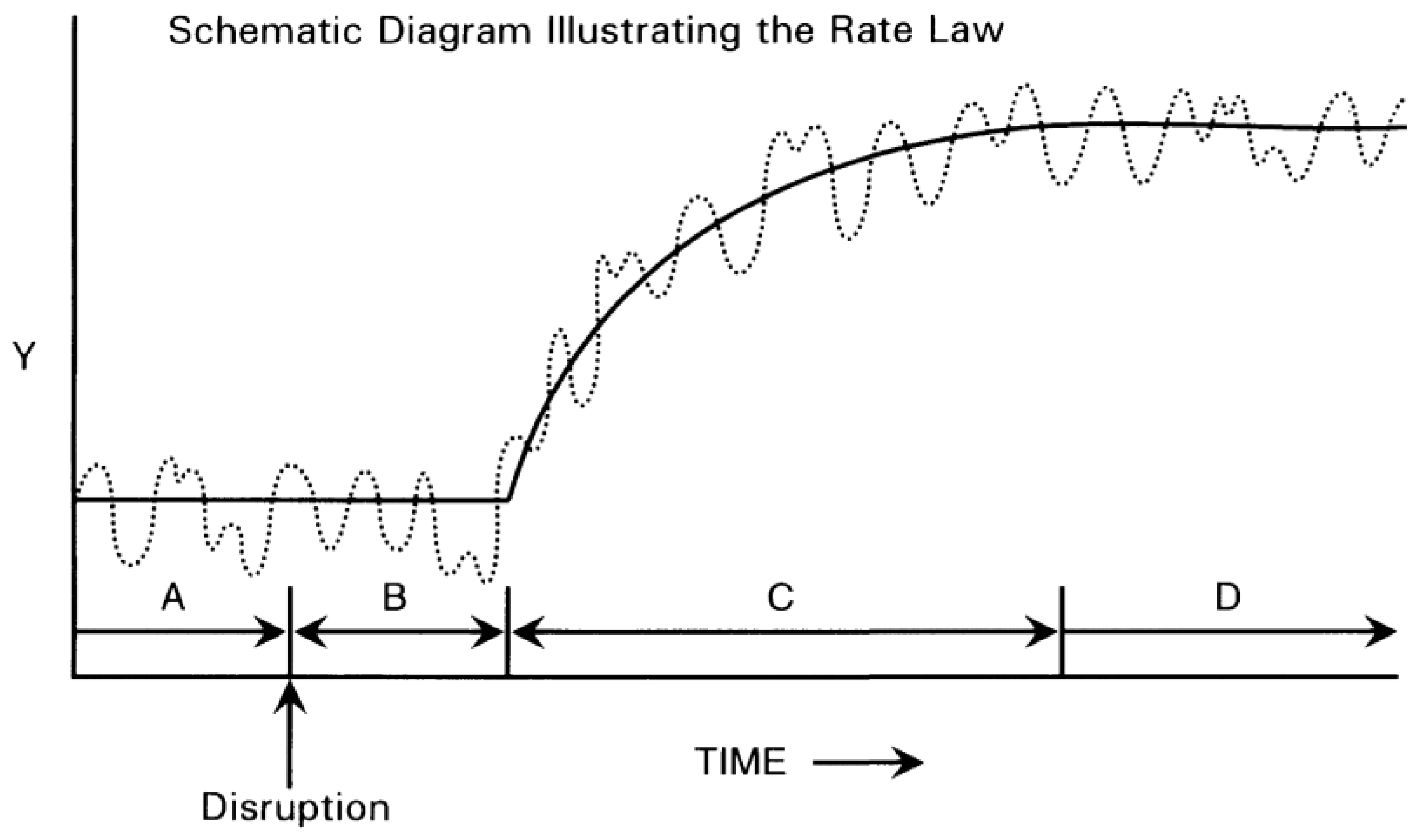
The Rate Law developed by Graf (1977) describes how a landform responds to disturbances that disrupt its equilibrium. According to the Rate Law [47] (Figure 1), an undisturbed geomorphic system (A) reacts to disruption in such a way that the system parameter Y (some dimensional or spatial characteristic of the system such as length or width) transitions to a steady state B after disruption where new conditions are internalised by the system. This is followed by a relaxation period C during which the system adjusts to new conditions. A new steady state is established in the next phase during D resulting in altered dimensional characteristics. When considering the response of a minescape to mine rehabilitation, the goal is generally for steady state D to be restored to state A or something similar.
That temporal relationship has the following four characteristics [47]:
- Changes in the inputs must result in measurable changes in outputs, either immediately or after a certain period. This criterion excludes cases where inputs have no impact on the output.
- The output value at a given time should be related to the input value(s) at the same time by a single, time-invariant functional relationship, within an acceptable degree of accuracy.
- The functional relationship must be testable in a repeatable manner, whether through experimental or observational methods.
- An equilibrium relationship may only apply within specific ranges of input values and/or specific rates of change of input values.
Equilibria may be stable or unstable and may be simple (such as point attractors) or more complicated (such as cyclic attractors). Systems may have more than one equilibrium state rather than a single state toward which the unperturbed system will tend. Some outputs may not be measurable in the stipulated amount of time required for mine rehabilitation assessment since some geomorphological changes are very slow. Equilibria are scale dependent and determining them is constrained by the researcher’s ability to handle a restricted number of variables simultaneously. Physically constraining the system (i.e identifying the boundary of the landform under supervision) is essential in geomorphology [48].
The equilibrium concept in mine rehabilitation requires the landform stability parameters to return back to their pre-mining levels once the mine site is rehabilitated. An equilibrium approach to assess mine site rehabilitation is developed in Nair, Bellairs [49] for the Ranger mine, Northern Territory, Australia. It is expected to determine the time until the mine site is fully rehabilitated and the dynamics of a mine site returning back to stability after a disturbance. A suitable parameter to analyze is fine suspended sediment in downstream waterways of the mine catchment, since it is an important parameter in mine site rehabilitation and offsite impact assessment. The aim of the approach was to determine how to assess if and when a rehabilitated mine landform has achieved erosion equilibrium with the surrounding catchment by using fine suspended sediment in stream water.
Fine suspended sediment quantity in the receiving waters of the mine landform as an indicator of landform stability is assessed by Nair, Evans [50]. Previous studies have used suspended sediment concentrations for monitoring disturbance by comparing values upstream and downstream of mine sites and with elevated trigger values to assess water quality deterioration [40]. Moliere and Evans [51] then developed the event FSS-discharge regression relationship following a rainfall event along with BACI to identify catchment disturbance. In Nair, Evans [50], the FSS-discharge relationship for rainfall events is used as a measure of erosional stability to identify the response to a known disturbance in the catchment (construction and revegetation of a trial waste rock landform). It evaluates rehabilitated mine landform stability based on FSS quantities in streams leaving the catchment where the mine resides. It assesses the variation of the fine suspended sediment discharge relationship at upstream and downstream of a catchment. Turbidity is a surrogate measure of FSS that is easier to measure [52]. Since geomorphological processes are very slow, stability assessments must be done for longer periods of time. Discharge and turbidity at the catchment outlet are easily quantifiable parameters that can be measured continuously and thus the data could be easily used for longer-term modeling and future simulations. Thus, it is much easier to collect continuous data in this method than slope stability, gully erosion and incision depth evaluations, which were used as land rehabilitation assessment tools in previous studies.
Parameterization of hydrology and LEM models to enable longer-term simulations using FFS relationships to assess mining rehabilitation dynamics has been carried out. Nair, Evans [53] describe the parameterization of the hydrology model (HEC-HMS), and Nair, Evans [54] assess the parameterization of the landform evolution model (CAESAR-Lisflood) for catchment modeling of the Ranger mine catchment. This avails calibration and validation of continuous fine suspended sediment quantity and discharge for the catchment model that can provide long-term future simulations. Subsequently, Nair, Bellairs [55] look at the temporal variation of fine suspended sediment discharge from the catchment for 1000 years into the future using the calibrated models. This study uses hydrology model simulations to determine fine variations in fine suspended sediment quantity for a discharge to comment on landform equilibrium across hundreds of years into the future and landform evolution model (CAESAR-Lisflood) to assess erosion and deposition characteristics of the catchment. CAESAR-Lisflood takes a long time to run the full Gulungul catchment for extended periods of time. Therefore HEC-HMS was investigated to simulate sediment loss from the catchment that can be used as input to CAESAR-Lisflood thus reducing the size of the DEM used in CAESAR-Lisflood and the time to iteratively design the final landform based on simulating erosion and sediment transport in receiving streams. The coupling of the models done in this study reduces the runtime whilst not compromising the accuracy of model simulations.
The FSS relationship was used to evaluate the erosion equilibrium dynamics of a rehabilitated landform reaching equilibrium under different rainfall scenarios on account of climate change [55]. While that study focuses on landform equilibrium, the stream fine suspended sediment movement is an important factor as it is a major contributor to contaminant transport. The methodology can be easily interpreted graphically and understood by the stakeholders involved in or affected by the rehabilitation process.
5. Outcomes and Achievements against Gaps
The approach was able to simulate long-term erosion equilibrium of a rehabilitated landform [49], evaluate stream-suspended FSS as an indicator of landform stability [50], simulate long-term mine catchment evolution using Lisflood [54], and model an upstream catchment in HEC-HMS [53] to simulate continuous discharge and FSS data for future years. The calibrated models were able to be used to run long-term simulations and evaluate erosion equilibrium of the mine catchment [55] for centuries after rehabilitation in average, drier and wetter climate scenarios.
Fine Suspended Sediment (FSS) spikes above the background relationship, in the creeks with catchments where the mine resides, can act as an indicator of catchment disturbance. The return to equilibrium of a landform following a catchment disturbance like mining can be determined by measuring the FSS load spikes and relating them to the expected relationship between event discharge (Q) and event FSS loads in the receiving streams following a rainfall event. This method is sensitive and can serve as a tool for evaluating mine landform rehabilitation. Field verification is essential to determine if the source of the disturbance is related to mining activities. This approach to assess post-mining landform stability requires continuous monitoring of turbidity (which is taken as a surrogate measure of FSS) and of discharge following rainfall events.
A major challenge to this methodology being used as a rehabilitation assessment tool, which needed to be resolved was that the FSS-Q relationship following a rainfall event is subject to temporal variation. Since geomorphological processes are very slow, equilibrium changes of the mine catchment take centuries to occur. The baseline FSS-Q relationship determined from past rainfall events were valid for that time period. Assessment of FSS spikes for future events were done in Nair, Bellairs [55] by simulating the catchment model for stream discharge and sediments in a hydrology model (HEC-HMS). The background relationship did not apply for simulated rainfall events that spanned centuries. The FSS-Q relationship determined from past events when applied for future simulated events gave higher FSS loads than the expected FSS values derived by modeling. This may be because the denudation rate of a landform decreased over the time period and thus the sediment erosion for a specific discharge also reduced with it. Moreover, the temporal and spatial variability of suspended sediment concentration in rivers are influenced by interactions between climate and catchment characteristics [56]. Thus, the FSS-Q baseline relationship must be updated for a time period to determine FSS spikes and thus the catchment disturbance.
The application of the approach to assess geomorphological changes of a rehabilitated mine landform for different rainfall scenarios was successful and the FSS loads returned to erosion equilibrium for the mine catchment after around 600 years [55]. It remained at erosion equilibrium for the rest of the 1000 years’ time period for which the average rainfall scenario was run. For the wetter rainfall scenario, it takes around 700 years until the FSS event loads return to background equilibrium levels for the rest of the years. For the drier rainfall scenario, the FSS event loads return to background levels by 600 years after rehabilitation but the values then rose above the equilibrium level in the next 300 years for high rainfall/high FSS load events. An advantage of this modeling approach is that it directly investigates the dynamics of a landform returning to equilibrium. It specifies the number of years taken to reach the equilibrium state in different climate conditions and the dynamics of the landform while attaining stability in each rainfall criteria. It builds on earlier studies [44] which states that the influence of a past process on a geomorphic system is directly proportional to the intensity and duration of the action and inversely to the elapsed time since its occurrence.
The time taken for a landform disturbed by open cut mining to be restored to its background erosion levels can take centuries. A change in one external variable causes readjustment of all system parameters and thus the geomorphic system responds as an organic whole to changes in the environment [57]. The study of Nair, Bellairs [55] found that the time and also the dynamics of returning back to equilibrium are influenced by hundreds of years of even minor changes in climatic factors. However, from the landform evolution modeling done with CAESAR-Lisflood, short-term future simulations show that the mine catchment undergoes distinct erosion and deposition in the vicinity of much-disturbed areas like the tailing dam during the initial few years after closure. Later, the landform settles in such a way that there is a general loss of sediment across all elevated areas of the catchment where the mine resides.
Running high resolution models can take substantial time, but by coupling of CAESAR-Lisflood 1.9b and HEC-HMS 4.11 the running time could be reduced. There are differences in running time between the CAESAR-Lisflood and the HEC-HMS models. During the modeling of the catchment for future simulations, the hydrology model could run faster and account for rainfall initial losses and continuous losses in the model, which is not available in CAESAR-Lisflood. Rainfall initial and continuous losses are the rainfall that does not result in overland flow. The initial loss represents the volume of water needed to saturate the soil layer at the beginning of the simulation and continuous loss refers to the rate at which precipitation is infiltrated into the soil layer after the initial loss volume has been accounted for. Thus HEC-HMS was run and output data was also used to produce input data for CAESAR-Lisflood for future simulations. This approach helps to fill the gaps in data for input in the models for future simulations. It also reduces the running time. The coupling of CAESAR-Lisflood 1.9b and HEC-HMS 4.11 reduced the running time and therefore the iterative design time of the final landform. It also gives different data outputs like the erosion and deposition features of the landform with a LEM and continuous stream discharge and sediment data with a hydrology model for the study.
This approach thus builds on previous studies and fills some of the knowledge gaps and deficiencies in other monitoring approaches that were previously identified in Section 3. One knowledge gap was that many techniques were site specific. The methodology used in this study can be easily adapted to other tropical mine sites as an assessment tool for landform stability. It requires the measurement of a minimal number of site parameters to assess erosion equilibrium. The approach considers the long-term trends of landform change until it attains stability. It can be used to evaluate the potential impacts of climate change on the erosion equilibrium of a disturbed landform. The approach investigates the quantity of fine suspended sediments, leaving the catchment and entering the receiving waters, which is directly linked to the transport of contaminants. Thus, this approach provides insight into the offsite impacts of mining. Apart from the development of an approach to assess mine landform stability, giving an estimate of the time until a rehabilitated landform achieves erosion equilibrium with the surrounding catchment is of value. The approach also determined the impacts of potential climate change on the dynamics of achieving stability and studied the temporal variability of the event fine suspended sediment-discharge relationship.
6. Broader Context of the Approach
The dynamics of a rehabilitated mine landform acquiring geomorphic equilibrium with the surrounding catchment can be simple, such that the unstable landscape may slowly move to equilibrium conditions and the stay at equilibrium. In another scenario, the landform might fluctuate in and out of equilibrium before finally reaching a steady state. The dynamics of a landform reaching equilibrium can be investigated in this method by evaluating the event FSS-discharge relationship across the years, which may not be possible using other techniques of rehabilitation assessment.
FSS event loads are sensitive to changing rainfall patterns on account of climate change. Thus, the climate change impacts on a landform returning to stability can be clearly assessed with this approach. FSS transport is also associated with contaminant transport. Contaminants that are released from a mine catchment due to disturbance attach themselves to FSS and thus it can also give an estimate of contaminant transport from the catchment to the receiving waters. Moreover, the methodology to assess landform equilibrium in this thesis focuses on offsite impact assessment of mining, which can be of much greater impact than the onsite impacts but is less attended to.
Using several models can aid parameterization for the approach. Nair, Evans [54] explores parameterisation of CAESAR-Lisflood LEM for continuous stream and fine suspended calibration. There was no available continuous site bedrock data pertaining to various particle size distribution which needs to be input into CAESAR-Lisflood for sediment calibration. Turbidity was used as a surrogate indicator of fine suspended sediment and previous studies on bedrock sediment proportions in stream sediment discharge were used to calculate sediment input in CAESAR-Lisflood LEM. This can enable this approach to be used where there is limited availability of continuous bedrock sediment data.
When parameterizing the HEC-HMS model for continuous stream discharge and fine suspended sediment calibration, Nair, Evans [53] show the hydrology model can run faster and account for rainfall initial and continuous losses in the model which is not available in CAESAR-Lisflood. Thus HEC-HMS was run by itself and also provided input data for CAESAR-Lisflood for future simulations. Combining the two models enabled the filling of data gaps and reduced the run time in a process that can be used in other simulations.
The temporal variation of the FSS-Q relationship could not be determined using past events as long-term site data is not available [49]. However, modeled data enabled long-term simulations [55]. The site data available were for a period of 2004 to 2015 [49]. Site data pertaining to larger time periods of more than a decade could enable analysis of temporal variation of fine suspended sediment -stream discharge relationship using real site values. However, the main aim of the methodology evaluation was successful, because the temporal variation of fine suspended sediment-stream discharge relationship was assessed using simulated data.
Communication with stakeholders about the rehabilitation of and achieving landform stability equilibria on mine sites is aided by this technique. When mining affects the lands of First Nations peoples as in the studies by Nair et al. [49,50,53,54,55], mined land rehabilitation should ensure that the disturbed land is rehabilitated such that it can be entrusted back and enjoyed by the original custodians of the land. Stakeholders wish to know the time until the rehabilitated landform is stable as in pre-mining conditions. Better understanding of the dynamics of how a mined landform returns to erosion equilibrium with its surrounding landform in different climatic conditions will enable rehabilitation engineers to estimate the timeframe for the process.
7. Limitations of the Approach
This approach can be applied to assess landform stability of mines in other tropical catchments using the step-by-step approach outlined in Nair, Bellairs [49]. One of the limitations in adapting the approach to another tropical catchment would be data availability. Continuous stream discharge and FSS data are required to establish the event FSS discharge relationship following rainfall events. The approach is best suited for catchments with receiving streams exhibiting continuous stream flow at least during the wet season of the year. Secondly, in order to investigate the catchment disturbance due to mining, it must be made sure that the disturbance is caused by mining alone. It would be difficult to account for FSS spikes on account of mining in catchments where other land use activities are also involved.
A limitation in Nair, Evans [54] was the inability to account for changes in catchment vegetation and changes in soil properties over the wet season in the CAESAR-Lisflood model. However, the CAESAR-Lisflood model was later used to assess the impact of the mine site on the downstream development of the catchment landform, focusing on sediment changes and geomorphology. This limitation of being unable to account for changes over the wet season was overcome in Nair, Evans [53] where the model (HEC-HMS) could calibrate continuous stream discharge and fine suspended sediment separately in the dry and wet seasons.
The constraint in Nair, Bellairs [55] was the much higher processing time taken by the landform evolution model to run at a higher resolution of the Digital Elevation Model (DEM). Running the model at lower resolution took less time to run but did not account for the major occurrences of erosion and deposition in the catchment. However, running the model at high resolution for a shorter time period revealed that the landform evolved after 20 years with similar trends as those developed by 5 years. Thus, it was not necessary to run the landform evolution model for the long-term, which would have taken more processing time since the trends were expected to be similar to short-term landform evolution.
8. Future Research Needs
Several prospects to develop the approach with further research should be investigated. The first would be to determine a technique to automatically determine the boundaries of fine suspended sediment discharge event spikes. This would allow for the development of an application that enables environmental officials to easily input landform values and parameters to assess stability. This can be approached by developing a model which can assess the FSS-Q regression relationship with the site data entered to the model and then compare it with the FSS spikes of the future simulations. This will involve identifying the start and end of FSS spike following a rainfall event and the corresponding discharge from continuous turbidity and discharge data respectively. It should enable computation of FSS event load and event discharge automatically by the application, determine a regression relationship between the two parameters and thus identify FSS spikes.
A greater range of extended rainfall scenarios should be assessed. Extended studies in Nair, Bellairs [55] included generating various future rainfall scenarios and then assessing the erosion equilibrium dynamics for these rainfall simulations. It was beyond the scope of that study to run a climate model for the rainfall data but running a climate model to attain extended and regional rainfall scenarios is an area of prospective research. This could be used to study the effect of climatic changes in rainfall on erosion equilibrium in detail.
The methodology should be tested in a range of other landscapes. The methodology has been tested for a mine catchment in a tropical savannah. Thus, it should be able to be applied to other tropical catchments where a mine resides for land stability assessments. Case studies could investigate other disturbances and other landscape types.
Author Contributions
Conceptualization: D.N and S.B.; methodology: K.E and D.N; formal analysis: K.E, D.N and S.B; writing—original draft preparation: D.N; writing—review and editing: D.N and S.B.; project administration: S.B and K.E. All authors have read and agreed to the published version of the manuscript.
Funding
Not applicable.
Data Availability Statement
Not applicable.
Acknowledgments
The Environmental Research Institute of the Supervising Scientist (eriss) is thanked for the provision of the data for this study. Professor Ken Evan’s time was provided by Surface Water & Erosion Solutions as an in-kind contribution.
Conflicts of Interest
The authors declare no conflicts of interest.
References
- Murray, A.B., E. Lazarus, A. Ashton, A. Baas, G. Coco, T. Coulthard, M. Fonstad, P. Haff, D. McNamara, and C. Paola, Geomorphology, complexity, and the emerging science of the Earth's surface. Geomorphology, 2009. 103(3): p. 496-505. [CrossRef]
- Winkler, K., R. Fuchs, M. Rounsevell, and M. Herold, Global land use changes are four times greater than previously estimated. Nature communications, 2021. 12(1): p. 2501. [CrossRef]
- Hooke, R.L., J.F. Martín-Duque, and J. Pedraza, Land transformation by humans: a review. GSA today, 2012. 22(12): p. 4-10.
- Regasa, M.S. and M. Nones. Impact of land use on soil erosion: Fincha watershed case. in 40th IAHR World Congress. Rivers – Connecting Mountains and Coasts. 2023. Vienna, Austria: IAHR – International Association for Hydro-Environment Engineering and Research. [CrossRef]
- Martín Duque, J.F., I. Zapico, R. Oyarzun, J.A. López García, and P. Cubas, A descriptive and quantitative approach regarding erosion and development of landforms on abandoned mine tailings: New insights and environmental implications from SE Spain. Geomorphology (Amsterdam, Netherlands), 2015. 239: p. 1-16. [CrossRef]
- Mudd, G.M., The sustainability of mining in Australia: key production trends and their environmental implications. Department of Civil Engineering, Monash University and Mineral Policy Institute, Melbourne, 2007.
- Australian Government. Closure and Rehabilitation Process of the Ranger Uranium Mine.Australian Government.Department of Agriculture,Water and Environment. 2020 10/10/2023]. Available online: https://www.environment.gov.au/science/supervising-scientist/ranger-mine/closure-rehabilitation.
- Howard, E., R. Loch, and C. Vacher, Evolution of landform design concepts. Mining Technology, 2011. 120(2): p. 112-117. [CrossRef]
- Grant, C., R. Loch, N. McCaffrey, S. Anstee, and D. Doley, Mine rehabilitation: leading practice sustainable development program for the mining industry. 2016.
- Dietrich, W.E., D.G. Bellugi, L.S. Sklar, J.D. Stock, A.M. Heimsath, and J.J. Roering, Geomorphic transport laws for predicting landscape form and dynamics. Geophysical Monograph-American Geophysical Union, 2003. 135: p. 103-132. [CrossRef]
- Tucker, G.E. and G.R. Hancock, Modelling landscape evolution. Earth Surface Processes and Landforms, 2010. 35(1): p. 28-50. [CrossRef]
- Evans, K., T. Aspinall, and L. Bell. Erosion prediction models and factors affecting the application of the Universal Soil Loss Equation to post-mining landscapes in Central Queensland. in Queensland Coal Symposium, Brisbane, Aust, 08/29-30/91. 1991.
- Evans, K.G., Determination of interrill erodibility parameters for selected overburden spoil types from Central Queensland open-cut coal mines. 1992: University of Queensland.
- Renard, K., J. Laflen, G. Foster, and D. McCool, The revised universal soil loss equation. Soil erosion research methods, 1994. 2: p. 105-124.
- Renard, K.G., Predicting soil erosion by water: a guide to conservation planning with the Revised Universal Soil Loss Equation (RUSLE). 1997: US Department of Agriculture, Agricultural Research Service.
- Wischmeier, W.H., Predicting rainfall erosion losses from cropland east of the Rocky Mountain. Agriculture handbook. Vol. 282. 1965, USA: U.S Department of Agriculture. 47.
- Williams, J., Sediment routing for agricultural watersheds 1. JAWRA Journal of the American Water Resources Association, 1975. 11(5): p. 965-974. [CrossRef]
- Djoukbala, O., M. Hasbaia, O. Benselama, and M. Mazour, Comparison of the erosion prediction models from USLE, MUSLE and RUSLE in a Mediterranean watershed, case of Wadi Gazouana (NW of Algeria). Modeling Earth Systems and Environment, 2019. 5(2): p. 725-743. [CrossRef]
- Knisel, W.G., CREAMS: A field scale model for chemicals, runoff, and erosion from agricultural management systems. 1980: Department of Agriculture, Science and Education Administration.
- Silburn, D. and R. Loch, Evaluation of the CREAMS model. I. Sensitivity analysis of the soil erosion sedimentation component for aggregated clay soils. Soil Research, 1989. 27(3): p. 545-561. [CrossRef]
- Loch, R., D. Silburn, and D. Freebairn, Evaluation of the CREAMS model. II. Use of rainulator data to derive soil erodibility parameters and prediction of field soil losses using derived parameters. Soil Research, 1989. 27(3): p. 563-576. [CrossRef]
- Miller, N. and O. Lee. Water Erosion Prediction Project Operational Computer Program. in National Water Conference, USA. 1989. ASCE.
- Lopes, V., M. Nearing, G. Foster, S. Finkner, and J. Gilley, The Water Erosion Prediction Project: Erosion Processes, in National Water Conference, USA, T.A.Austin., Editor. 1989, ASCE.
- Kirkby, M., Hillslope process-response models based on the continuity equation. Inst. Br. Geogr. Spec. Publ, 1971. 3(1): p. 5-30.
- Willgoose, G., R. Bras, and I. Rodriguez-Iturbe. Modelling of the Erosional Impacts of Landuse Change: A New Approach Using a Physically Based Catchment Evolution Model. in Hydrology and Water Resources Symposium 1989: Comparisons in Austral Hydrology; Preprints of Papers. 1989. Institution of Engineers, Australia.
- Howard, A.D., A detachment-limited model of drainage basin evolution. Water resources research, 1994. 30(7): p. 2261-2285. [CrossRef]
- Howard, A.D., Badland morphology and evolution: Interpretation using a simulation model. Earth Surface Processes and Landforms: The Journal of the British Geomorphological Group, 1997. 22(3): p. 211-227.
- Tucker, G.E., Modeling the large-scale interaction of climate, tectonics, and topography. 1996: Pennsylvania State, Earth System Science Center, College of Earth & Mineral Sciences.
- US Army Corps Engineers, H.E.C. HEC HMS. 2023 [cited 2023 07 June 2023]. Available online: https://www.hec.usace.army.mil/software/hec-hms/.
- Van Der Knijff, J.M., J. Younis, and A.P.J. De Roo, LISFLOOD: a GIS-based distributed model for river basin scale water balance and flood simulation. International Journal of Geographical Information Science, 2010. 24(2): p. 189-212. [CrossRef]
- Bates, P.D., M.S. Horritt, and T.J. Fewtrell, A simple inertial formulation of the shallow water equations for efficient two-dimensional flood inundation modelling. Journal of Hydrology, 2010. 387(1-2): p. 33-45. [CrossRef]
- US Army Corps Engineers, H.E.C., HEC-RAS 2023.
- Shustikova, I., A. Domeneghetti, J.C. Neal, P. Bates, and A. Castellarin, Comparing 2D capabilities of HEC-RAS and LISFLOOD-FP on complex topography. Hydrological Sciences Journal, 2019. 64(14): p. 1769-1782. [CrossRef]
- Coulthard, T.J., J.C. Neal, P.D. Bates, J. Ramirez, G.A. de Almeida, and G.R. Hancock, Integrating the LISFLOOD-FP 2D hydrodynamic model with the CAESAR model: implications for modelling landscape evolution. Earth Surface Processes and Landforms, 2013. 38(15): p. 1897-1906. [CrossRef]
- Beven, K.J. and M.J. Kirkby, A physically based, variable contributing area model of basin hydrology/Un modèle à base physique de zone d'appel variable de l'hydrologie du bassin versant. Hydrological Sciences Journal, 1979. 24(1): p. 43-69.
- Mudd, G.M. and J. Patterson, Continuing pollution from the Rum Jungle U–Cu project: A critical evaluation of environmental monitoring and rehabilitation. Environmental Pollution, 2010. 158(5): p. 1252-1260. [CrossRef]
- Jeffree, R., Characterisation of the impacts of pre-and post-remedial contaminant loads from the Rum Jungle on riparian vegetation and fishes of the Finniss River system. 2002, Environment Division, ANSTO, PMB 1 Menai, NSW 2234, Australia.
- Edwards, C., An evaluation of seasonal change in Benthic Macroinvertebrate community composition in the east branch of the Finniss River. 2002, Environment Division, ANSTO, PMB 1 Menai, NSW 2234, Australia.
- Northern Territory Government, Former Rum Jungle Mine Site Conceptual Rehabilitation Plan. Department of Primary Industries and Resources. 2013.
- Zapico, I., J.B. Laronne, C. Martín-Moreno, J.F. Martín-Duque, A. Ortega, and L. Sánchez-Castillo, Baseline to Evaluate Off-Site Suspended Sediment-Related Mining Effects in the Alto Tajo Natural Park, Spain. Land Degradation & Development, 2017. 28(1): p. 232-242. [CrossRef]
- Martín-Moreno, C., J.F. Martin Duque, J.M. Nicolau Ibarra, N. Hernando Rodriguez, M.A. Sanz Santos, and L. Sanchez Castillo, Effects of topography and surface soil cover on erosion for mining reclamation: the experimental spoil heap at El Machorro Mine (Central Spain). Land Degradation & Development, 2016. 27(2): p. 145-159. [CrossRef]
- Batalla, R.J. and D. Vericat, A review of sediment quantity issues: Examples from the River Ebro and adjacent basins (Northeastern Spain). Integrated Environmental Assessment and Management, 2011. 7(2): p. 256-268. [CrossRef]
- Kjelland, M.E., C.M. Woodley, T.M. Swannack, and D.L. Smith, A review of the potential effects of suspended sediment on fishes: potential dredging-related physiological, behavioral, and transgenerational implications. Environment Systems and Decisions, 2015. 35: p. 334-350. [CrossRef]
- Howard, A.D., Geomorphological systems; equilibrium and dynamics. American Journal of Science, 1965. 263(4): p. 302-312. [CrossRef]
- Howard, A.D., Equilibrium and time scales in geomorphology: Application to sand‐bed alluvial streams. Earth Surface Processes and Landforms, 1982. 7(4): p. 303-325. [CrossRef]
- Howard, A.D., Equilibrium models in geomorphology. Modelling Geomorphological Systems, 1988: p. 49-72.
- Graf, W.L., The rate law in fluvial geomorphology. American Journal of Science, 1977. 277(2): p. 178-191. [CrossRef]
- Thorn, C.E. and M.R. Welford, The equilibrium concept in geomorphology. Annals of the Association of American Geographers, 1994. 84(4): p. 666-696. [CrossRef]
- Nair, D., S.M. Bellairs, and K. Evans, An approach to simulate long-term erosion equilibrium of a rehabilitated mine landform, in Mine Closure 2022: 15th International Conference on Mine Closure, M.T. A.B. Fourie and G. Boggs, Editors. 2022, Australian Centre for Geomechanics: Brisbane. p. 1063-1074.
- Nair, D., K. Evans, S. Bellairs, and M.R. Narayan, Stream Suspended Mud as an Indicator of Post-Mining Landform Stability in Tropical Northern Australia. Water, 2021. 13(22): p. 3172. [CrossRef]
- Moliere, D.R. and K.G. Evans, Development of trigger levels to assess catchment disturbance on stream suspended sediment loads in the Magela Creek catchment, Northern Territory, Australia. Geographical Research, 2010. 48(4): p. 370-385. [CrossRef]
- Moliere, D., M. Saynor, and K. Evans, Suspended sediment concentration-turbidity relationships for Ngarradj - a seasonal stream in the wet-dry tropics. Australasian Journal of Water Resources, 2005. 9(1): p. 37-48. [CrossRef]
- Nair, D., K.G. Evans, and S.M. Bellairs, Sediment Modelling of a Catchment to Determine Medium-Term Erosional Trends. Land, 2023. 12(9): p. 1785. [CrossRef]
- Nair, D., K.G. Evans, and S. Bellairs, Modelling of a Post-Mining Catchment for Future Simulations. Mining, 2023. 3(3 ): p. 409-427. [CrossRef]
- Nair, D., S.M. Bellairs, and K. Evans, Simulating long-term erosion equilibrium of a rehabilitated mine landform (Under Review), in Mine Closure 2024: 17th International Conference on Mine Closure, M.T. A.B. Fourie and G. Boggs, Editors. 2024, Australian Centre for Geomechanics: Perth.
- Shin, J.h., R.C. Grabowski, and I. Holman, Catchment and climatic influences on spatio-temporal variations in suspended sediment transport dynamics in rivers. Hydrology Research, 2023. 54(8): p. 901-923. [CrossRef]
- Hall, A. and R. Fagen, Definition of a system. General System. Society for the advancement of General Systems Theory, 1956. 1: p. 1-10.
Figure 1.
Representation of Rate Law [47].
Figure 1.
Representation of Rate Law [47].
Disclaimer/Publisher’s Note: The statements, opinions and data contained in all publications are solely those of the individual author(s) and contributor(s) and not of MDPI and/or the editor(s). MDPI and/or the editor(s) disclaim responsibility for any injury to people or property resulting from any ideas, methods, instructions or products referred to in the content. |
© 2024 by the authors. Licensee MDPI, Basel, Switzerland. This article is an open access article distributed under the terms and conditions of the Creative Commons Attribution (CC BY) license (http://creativecommons.org/licenses/by/4.0/).
Copyright: This open access article is published under a Creative Commons CC BY 4.0 license, which permit the free download, distribution, and reuse, provided that the author and preprint are cited in any reuse.


