Submitted:
14 September 2024
Posted:
16 September 2024
You are already at the latest version
Abstract
Keywords:
1. Introduction
2. Materials and Methods
- stage - processing of measured data, which includes procedures of frequency analysis (filtering, obtaining Fourier series coefficients) and procedures of working with matrices (matrix inversion by Moore- Penrose method, or singular matrix decomposition);
- stage - inversion (transformation) of response functions into a section consisting of earth layers. The solution of the inverse problem of MTZ usually includes the solution of the direct problem and one of the fitting methods. Response function transformation is used when a quick but coarse estimate of the geoelectric section is required. Sometimes this assessment turns into an assessment of the quality of the measured data, in such cases the measurements have to be repeated.
3. Results
3.1. Ore Minerals Deposits
3.2. Hydrocarbon Deposits
4. Discussion
Nature of Transcrustals Fluid- and Magma- Conducting Channels
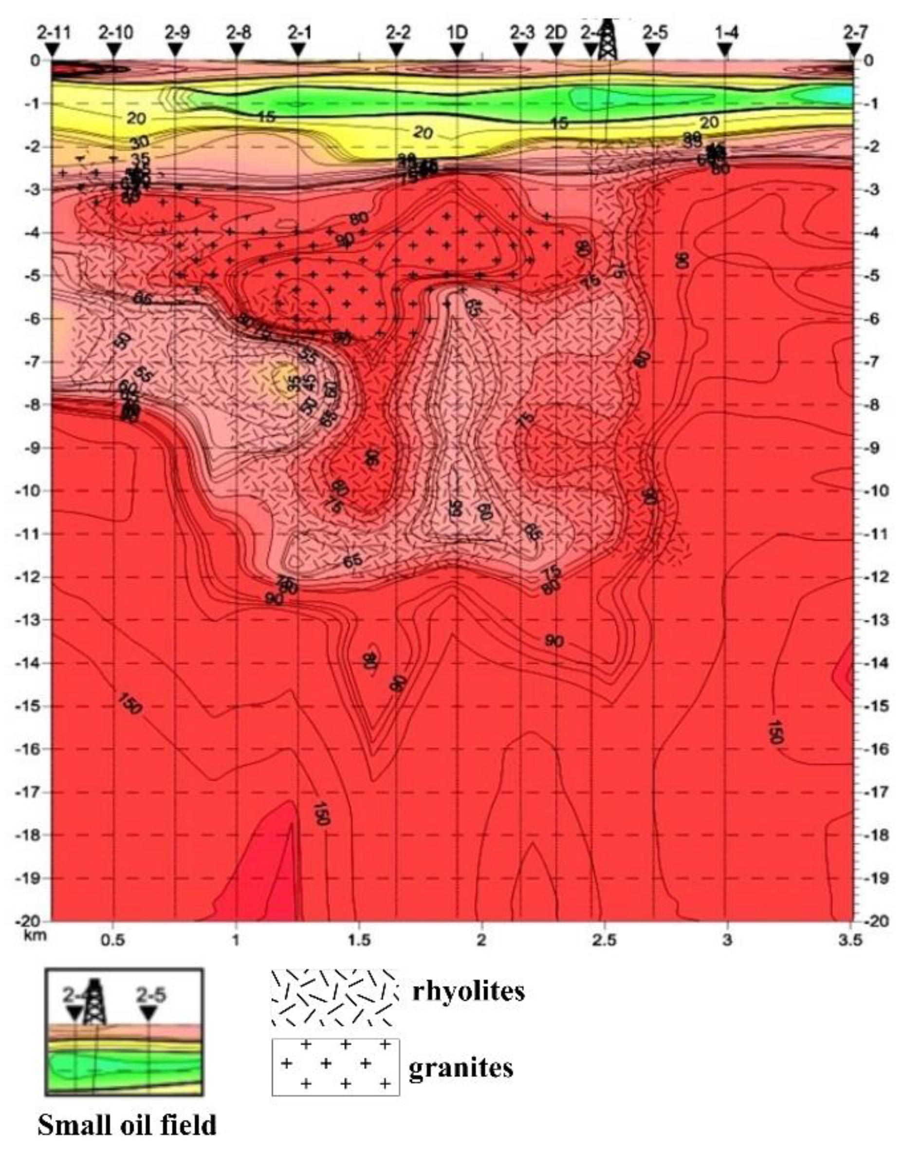
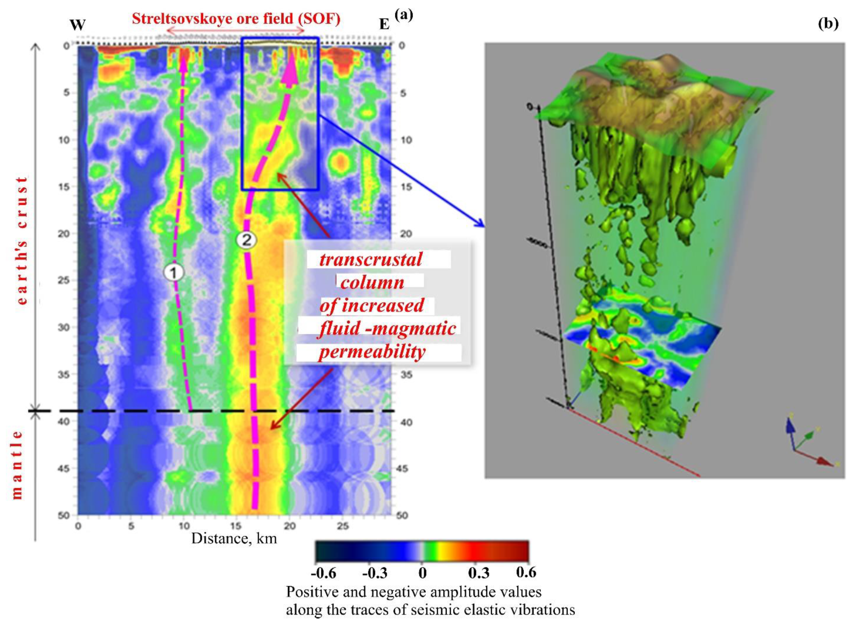
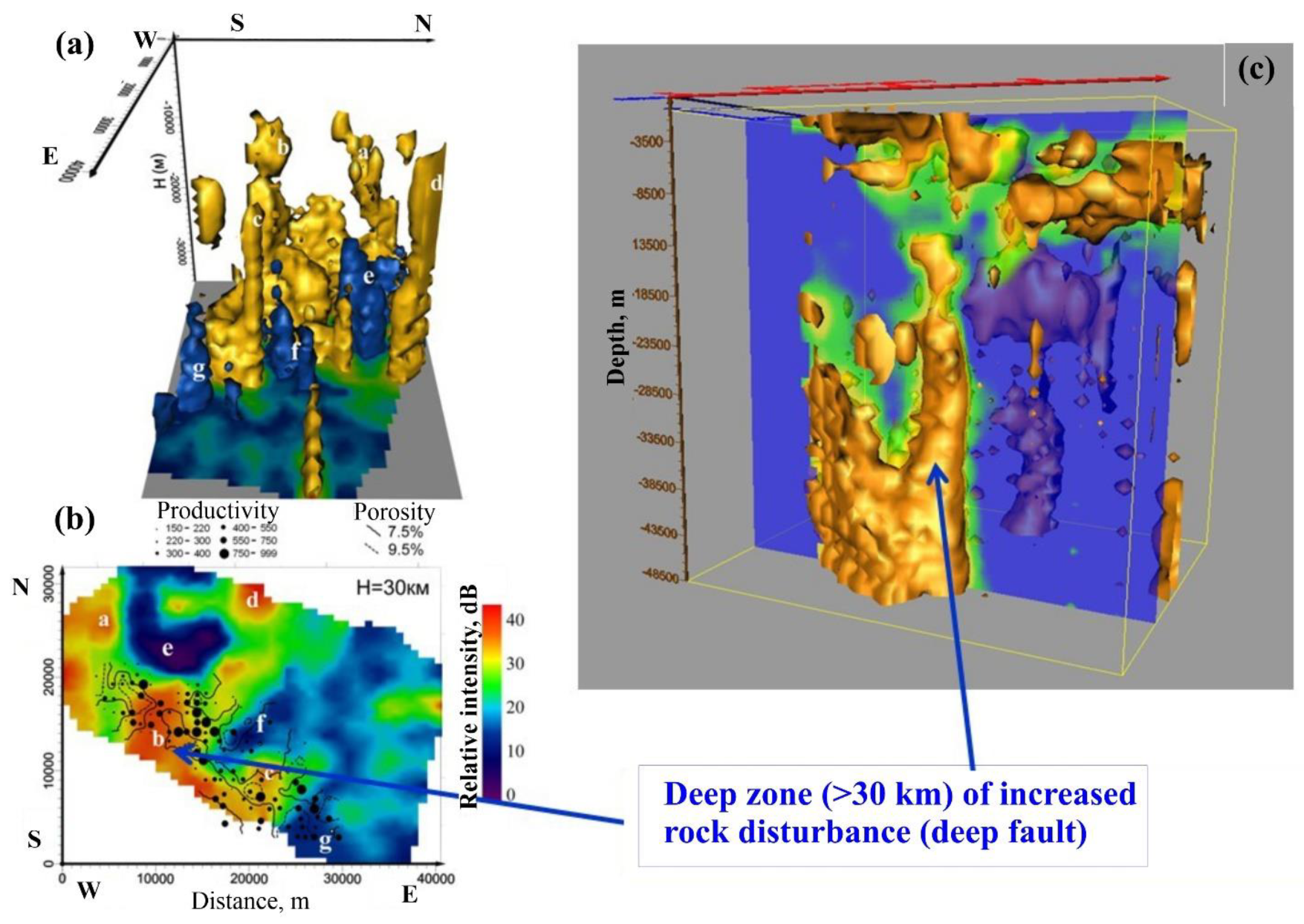
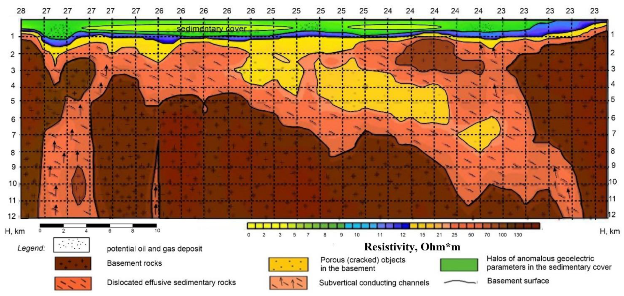
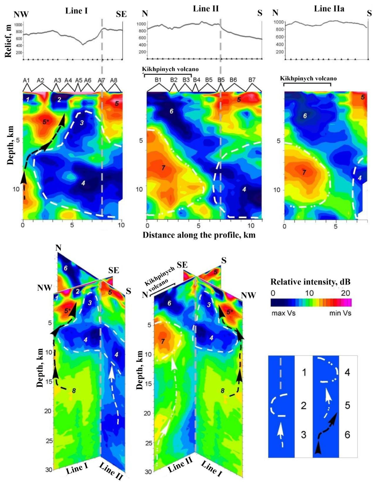
- an ancient shallow-depth crystallized magmatic source (intrusive) of acidic composition of irregular shape in the depth range from 2–3 to 10–12 km beneath the eastern part of the Uzon -Geyser Depression (structures 3 and 4, outlined with white dashed lines);
- magma chamber (basaltic melts concentration area) in the depth range of 15–20 km beneath the ancient crystallised hearth (structure 8);
- modern peripheral magmatic centre (area of basaltic melt concentration) beneath Kikhpinych volcano in the depth of 5–10 km (structure 7, outlined by white dashed line);
- crystalline basement from deeper horizons (subvertical heterogeneities, which are marked by white dashed lines with arrows).
5. Conclusions
5.1. Ore minerals Deposits
5.2. Hydrocarbon Fields
5.3. Nature of Transcrustal Fluid- and Magma -Conducting Channels
6. Patents
Acknowledgments
Conflicts of Interest
References
- Kotova N.P. Geotectonic features of formation and mineralogenic zoning of Eastern Transbaikalia for fluorite // Vestnik of ZabSU. 2011. No. 12. URL: https://cyberleninka.ru/article/n/geotektonicheskie-osobennosti-formirovaniya-i-mineragenicheskoe-rayonirovanie-vostochnogo-zabaykalya-na-flyuorit.
- Samsonov Ya.P., Savelyev A.K. Geology of deposits of fluorine-containing raw materials. – M.: Nedra, 1980. – 216 p.
- Alieva O.Z., Koplus A.V., Evolutionary model of ore potential formation of fluorite epithermal mineralization // III International Conference "New Ideas in Earth Sciences": report summary. - V. 2. - M., 1997.
- Harland W.B., Armstrong R.L., Cox A.W., A. Geologic Time Scale // Cambridge University Press. – 1989.
- Iskandarov M.Kh., Abdullaev G.S., Mirzaev A.U., Khakimzyanov I.N., Umarov Sh.A. Scientific and innovative research of oil and gas formation processes in Ustyurt oil and gas region - Oil province. 2022. No. 3(31). P.23-55. [CrossRef]
- Laverov N.P., Velichkin V.I., Vlasov B.P., Aleshin A.P., Petrov V.A. Uranium and molybdenum-uranium deposits in areas of development of continental intracrustal magmatism: geology, geodynamic and physicochemical conditions of formation. Moscow: IFZ RAS, IGEM RAS, 2012. 320 p.
- Abetov A.E., Alyoshin A.P., Akhmetov E.M., Gorbatikov A.V., Erdyakov I.L., Malyshev O.A. Innovative method of microseismic sounding as an effective tool for studying the structures of oil and ore deposits - Abstracts for the forum " KGF, Oil & Gas, 2015", Astana, 2015.
- Thomson I.N., Krivtsov V.S., Kochneva N.T. et al. Ore-bearing capacity of continental volcanic belts. – Moscow: Nedra, 1982.
- Zubkov V.S. Tendencies in the distribution and hypotheses of the genesis of condensed naphthides in magmatic rocks from various geodynamic environments. Geochem. Int. 47, 741–757 (2009), no. 8. [CrossRef]
- Lurye M.A., Schmidt F.K. Sulfur content, metalliferousness, carbon and sulfur isotopy of oils as genetic characteristics // Electronic journal "Deep Oil", 2013. Vol. 1. No. 4. Pp. 448-459. URL: http://journal.deepoil.ru/images/stories/docs/DO-1-4-2013/4_Lurije-Shmidt_1-4-2013.pdf.
- Balitsky V.S., Bondarenko G.V., Pironon J., Penteley S.V., Balitskaya L.V., Golunova M.A., Bublikova T.M. On the causes of vertical zoning in hydrocarbon distribution in earth interior: experimental evidence of crude oil cracking in high-temperature aqueous-hydrocarbon fluids. Superkriticheskie Flyuidy: Theory i Praktika, V8, 2, 39-60 (2013). https://scf-tp.ru/articles/2013_02/3_r.html.
- Abetov A.E., Alyoshin A.P., Akhmetov E.M., Gorbatikov A.V., Erdyakov I.L., Malyshev O.A. Identification of transcrustal magmatic and fluid -conducting ore-generating structures using an innovative method of microseismic sounding (MSS). To the meet “Modern problems of geology, geophysics and metallogeny”, Tashkent, 2015, pp. 13-18.
- Bazhenova O.K., Burlin Yu.K., Sokolov B.A., Khain V.E. Geology and Geochemistry of oil and gas. Moscow, Moscow State University, 2012. 432 p.
- Abidov A.A. Mixgenetic scheme of natural hydrocarbon synthesis of HC and its significance for prediction oil and gas content of regional oil and gas bearing structures and geodynamic conditions of oil and gas formation and oil and gas accumulation in the Earth's crust. // Tashkent. 2002.
- Barenbaum A.A. New ideas about the origin of oil and gas in connection with the discovery of the phenomenon of replenishment of reserves of exploited fields - Georesources / Georesources, 2019. Vol. 21. No. 4. pp. 34-39. [CrossRef]
- Iktisanov V.A. Synthesis rate during field development. Oilfield Business, No. 4, 2017, pp. 49-54.
- Tleubergenova A.K., Umirova G.K., Portnov V.S., Mausimbaeva A.D. High-precision aeromagnetic survey on the Shu-Sarysu geotraverse // Oil and Gas. - Almaty, 2023, No. 3 (135), pp. 52-67, ISSN 1562-2932. [CrossRef]
- Tleubergenova A., Umirova G., Maussymbayeva A., Portnov V. Comprehensive analysis of magnetic and gravity data based on volumetric gravity-magnetic modelling along the geotraverse in the Shu- Sarysu sedimentary basin // Vol. 3 No. 102 (2023): Visnyk of Taras Shevchenko National University of Kyiv. Geology, pp. 31-37. [CrossRef]
- Gorbatikov A.V., Stepanova M.Y., Korablev G.E. Microseismic field affected by local geological heterogeneities and microseismic sounding of the medium. Izv., Phys. Solid Earth 44, 577–592 (2008). [CrossRef]
- Gorbatikov A.V., Tsukanov A.A. Modelling of Rayleigh waves near scattering velocity inhomogeneities. Investigation of possibilities of the method of microseismic sounding // Physics of the Earth. 2011. No. 4. P. 96-112.
- Abkadyrov I.F., Gorbatikov A.V., Stepanova M.Yu., Bukatov Yu.Yu. Experience of application of the method of microseismic sounding of geothermal fields on the example of Nizhne- Koshelevskaya / thermoanomaly (South Kamchatka) / Proceedings of the 19th regional youth scientific conference "Natural environment of Kamchatka", Petropavlovsk-Kamchatsky, 2010. P.49-59.
- Pospeev A.V., Seminski, I.K., Nemtseva D.B. First results of magnetotelluric soundings for mapping the Riphean sediments of the Baikal foredeep. Geodynamics and Tectonophysics, 2021, 12(3S): 769-775. [CrossRef]
- Tleubergenova A., Umirova G., Karpenko O., Maussymbayeva A. Geoelectrical model of the earth's crust along the Shu-Sarysu geotraverse according to magnetotelluric soundings. Naukovyi Visnyk Nationalnoho Hirnychoho Universytetu, 2023, (3), pp.3-10. [CrossRef]
- Petrov V.A., Andreeva O.V., Poluektov V.V., Kovalenko D.V. Uraniferous volcanogenic structures: Streltsovskaya (RF), Xianshan (China) and McDermitt (USA). Comparative analysis of the petrology of acid volcanics and the composition of near-ore metasomatites. Geology of ore deposits, 2022, Vol. 64, No. 1, pp. 7-36. [CrossRef]
- Gorbatikov A.V., Stepanova M.Yu., Tsukanov A.A., Tinakin O.V., Komarov A.Yu., Odintsov S.L., Tokman A.K. New technology of microseismic sounding for studying the deep structure of oil and gas fields // Oil industry, 2010. No. 6. P. 15-17. https://oil-industry.net/en/Journal/archive_detail.php?ID=8978&art=186801.
- Madisheva R.K., Portnov V.S., Amangeldiyeva G.B. et al. Geochemical prerequisites for the formation of oil and gas accumulation zones in the South Turgay basin, Kazakhstan. Acta Geochim 43, 520–534 (2024). [CrossRef]
- Wang, S.M., Di, Q.Y., Zou, G.A. et al. Electrical resistivity imaging in Shibaozhai area using magnetotelluric sounding: Enlightenment of hydrocarbon reservoirs on the eastern edge of the Sichuan Basin. Appl. Geophys. 19, 294–305 (2022). [CrossRef]
- He Meixing, PEI Fagen, FANG Hui, et al. Electrical structure and geological controlling factors of natural gas hydrates in Muli, Qilian Mountains[J]. Journal of Central South University (Science and Technology), 2022, 53(3): 879-889. [CrossRef]
- He Faqi, YU Wenhui, MA Chao, ZHANG Shihui, LI Xiaowei, LI.U. Demin.2024. Deep structure and genesis of Sanmenxia fault basin and its adjacent area: Evidence from deep seismic reflection and magnetotelluric sounding[J]. Acta Geologica Sinica, 98(4):1088-1100, 2024. [CrossRef]
- Abdullaev G.S., Dolgopolov F.G., Tukhtaev K.M., Toshkulov A.Zh. Multilevel regmatic systems and fault -block structure of the South Ustyurt depression. // Actual problems of oil and gas. Moscow. 2020. Issue. 1(28). [CrossRef]
- Sysoev B.K., Yagafarov A.K., Arsan S.A., Khudyakov D.S., Savina M.E. Features of magnetotelluric scanning of the Earth's crust while searching and exploring hydrocarbon deposits. Oil and Gas Studies. 2019;(5):40-45. (In Russ.). [CrossRef]
- Yanitsky I.N. Fluid regime of the Earth in the light of high-frequency geodynamics/Proceedings of the International Conf. “Degassing of the Earth: geodynamics, geofluids, oil and gas” Moscow: “GEOS”, 2002. Pp. 281-283).
- Bashorin V.N., Borodzich E.V., Korobeynik V.M. et al. Heliemetric and prognostic studies at estimation the reliability of industrial sites of responsible engineering constructions. - Collection. "Assessment of seismo-tectonic conditions of nuclear power plant construction sites of ". Moscow: Energoatomizdat, 1987. Pp. 28-37.
- Yanitsky I.N. About fluid-conducting thermohydromassives in the Earth interior (scientific and applied aspects of fluid dynamics) / Proceedings of the conference “Tectonics, geodynamics and magmatism processes” Moscow: RAS, 1999. Pp. 332-336.
- Ponomarev A.S. Thermal and gas -dynamic model of crustal earthquakes// Physics of the Earth, 1990, No. 10. P. 100-112.
- Yanitsky I.N. The concept of N.S.Shatsky “About modern faults on platforms in the light of heliometric and prognostic studies” / Materials of meeting “General issues of tectonics” M.: “GEOS”, 2000. P. 633-637.
- Kugaenko Yu. A., Saltykov V. A., Gorbatikov A. V., Stepanova M. Yu. Development of the model of the Uzon -Geysernaya volcano -tectonic depression area and the Kikhpinych volcano (Kamchatka) based on the results of a joint analysis of microseismic sounding data and local geodynamic activity – Moscow, Physics of the Earth, 2015, No. 3, pp. 89–101. [CrossRef]
- Gufeld I.L. Geological consequences of amorphisation of the lithosphere and upper mantle structure caused by hydrogen degassing. Geodynamics and Tectonophysics. 2012;3(4):417-435. [CrossRef]
- Marakushev A.A., Marakushev S.A. Fluid Evolution of the Earth and Origin of the Biosphere. in “Man and the Geosphere.” Chapter 1", p. 3-31, Florinsky I.V. (Ed.), 2010. https://www.webofscience.com/wos/WOSCC/full-record/000283640000001, Nova Science Publishers, Inc. New York, 385 p.


Disclaimer/Publisher’s Note: The statements, opinions and data contained in all publications are solely those of the individual author(s) and contributor(s) and not of MDPI and/or the editor(s). MDPI and/or the editor(s) disclaim responsibility for any injury to people or property resulting from any ideas, methods, instructions or products referred to in the content. |
© 2024 by the authors. Licensee MDPI, Basel, Switzerland. This article is an open access article distributed under the terms and conditions of the Creative Commons Attribution (CC BY) license (http://creativecommons.org/licenses/by/4.0/).


