1. Introduction
In recent years, multiple linkages between cultural heritage and geoheritage were identified and highlighted [
1,
2], although the term "geoheritage" is more often related to rock, fossil and landform records [
3]. The themes underlying geoconservation contribute to cultural heritage especially in an urban context, for example where the preservation of buildings of cultural interest also involves adequate consideration of building-stone heritage. Therefore, the heritage stone represents a theme of interest with numerous examples from European cities and the World Heritage Committee of UNESCO stated in 1972 that it is not possible to separate natural from built heritage [
4].
The geological background of these cities can be read not only in famous historical buildings erected from characteristic stones and from the way in which these rocks are assembled and worked, but also from the sites of stone extraction, that is ancient quarries, often located within the cities or in the subsoil [
5].
The use of natural mineral resources is also considered a topic at the interface between geoheritage and cultural heritage, aspects that are readable in the various sites and methods of extraction, up to the use of rock blocks and their transport to destination sites. From this perspective quarrying can be considered part of cultural heritage, including excavation techniques; the architecture of the underground cavities, up to their subsequent reuse, is sometimes also converted into burial areas (under places of worship) and is in turn included in “cemeterial geotourism” [
6,
7]. These artificial cavities are considered the witness of the historical relationship between man and territory and have become the object of study as an "underground heritage", also emphasizing the use of stone resources in buildings, including dwelling houses and conversion to other uses [
8].
Therefore, for this reason the enhancement of the architectural, artistic and landscape heritage cannot be separated from a detailed knowledge of the underground environments of anthropic origin. The growth of cities has not only obliterated previous landforms, but has also eliminated trace/evidence of the sites of origin of building stones, to the point of representing a risk for their susceptibility to sinkholes where these sites are in the subsoil [
9,
10,
11,
12,
13]. This is even more dramatic when it happens underneath buildings of historical and cultural interest. From this perspective, the Italian Speleological Society provided a recognition and a Classification of Artificial Cavities, later adopted by the International Union of Speleology [
14,
15], thus attributing a cultural dimension to mining and quarrying that has received increasing recognition from the World Heritage Committee of UNESCO [
2].
Geoheritage aspects also benefit from the support of artistic and literary documentation. Art presentations of sites that have been destroyed or altered can help to decipher the landform changes that occurred through time and to read any signal of the past characteristics [
16]. In this sense, analysis of paintings, postcards and historical maps would help understanding the above changes and to valorize what remains as evidence of them. It is well known, in fact, that bibliographic and archival sources are essential for tracing and understanding the different socio-cultural contexts that have occurred during the various eras [
17] and which have determined important urban and landscape transformations [
18,
19,
20]. Historical cartography offers a unique perspective on the geospatial development of an area [
21]: historical maps not only represent territories, but also reflect the perception and knowledge of the world in different eras [
22], and therefore allow to trace urban expansion and landscape transformations, offering insights into urban planning and infrastructure development [
23], and, with the support of historical sources, valuable information for the conservation and valorization of the historical-architectural heritage [
24]. Ancient illustrations (author's drafts, drawings and photographs) are a window on the past as well, offering a visual confirmation of places and a detailed picture of their transformations over time, contributing to the understanding of evolution [
25,
26,
27,
28].
Finally, it should be underlined that many sites, which are recognized as having a high cultural value, also as UNESCO World Heritage sites, can contain interesting information both in terms of landforms and rock outcrops [
29] which, in turn, significantly help in the interpretation of the history and evolution of these cultural heritage sites [
30].
In northern Campania (Southern Italy), the historic center of many towns is characterized by the widespread presence of underground cavities excavated in the pyroclastic deposits widely distributed in the subsoil of the plain areas [
31,
32,
33,
34,
35,
36,
37,
38,
39,
40,
41]. These environments testify to the multi-centennial exploitation of local geo-resources through the extraction of tuff rock, widely used in constructions, from ancient age structures to the seventeenth-century churches and palaces, passing through medieval convents and basilicas, up to modern-age constructions [
42]. The resulting underground environments responded then to various social needs, such as the conservation of agricultural products, the burial of the dead, the cult of saints, and the general hydraulic needs of inhabited areas such as transport and storage of water, both rain and spring. Therefore, these underground environments, in addition to guarding any archaeological finds, are themselves architectural assets of considerable cultural and scientific value.
On this basis and considering the importance of such elements as attractors for tourism, a multidisciplinary study was conducted on a worship in the Caserta area: the Monumental Complex of San Francesco le Moniche, in Aversa (XIII century CE). The stratification of the complex can be read not only from documentary sources, but also from the distribution and architecture of the existing cavities and from ancient images, even postcards. The recovery can certainly be included in a geotourism itinerary also based on virtual travel.
2. Study Area
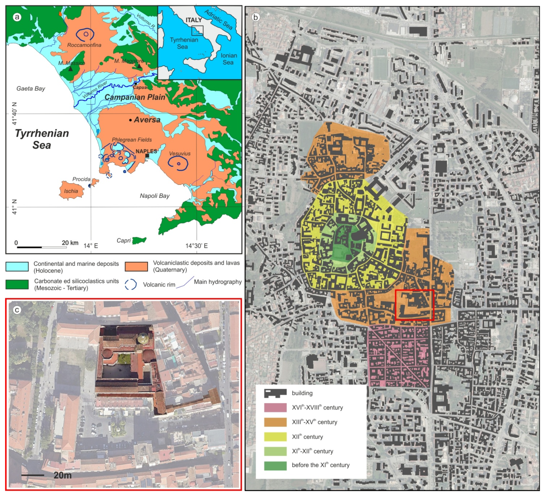
The study area, in north-western part of Campania Region (Italy;
Figure 1a) corresponds to the northern and north-eastern part of the Campania Plain, a broad, complex graben closely controlled by NE-SW, NW-SE and E-W normal fault activity, along the Tyrrhenian side of the Apennine Mountains. The sedimentary evolution of this graben was conditioned by the fluvial and marine processes and the volcanic activity of the Campi Flegrei, Somma-Vesuvious and Roccamonfina volcanoes [
43,
44,
45,
46,
47].
The considered sector of the plain is characterized by a flat morphology between 95 and 20 m a.s.l. In this area the subsoil is formed by the succession of different units composed of volcanoclastic deposits, in particular related to the Campania Grey Tuff (CGT; 39 ky B.P) [
48] and Neapolitan Yellow Tuff (NYT; 15 ky B.P.) [
49] piroclastic eruptions from the Campi Flegrei volcanic district [
50].
The CGT deposits, in particular, were settled on the whole Campania Plain, giving rise to a thick (up to 40 m thick), laterally continuous, volcanoclastic unit, characterized by different lithofacies mostly derived from the different mineralogic composition [
51,
52,
53]. The good mechanical characteristics of the tuff lithofacies justify the presence of numerous quarries and/or cavities, according to the availability of adequate thicknesses of coherent lithofacies [
40,
41].
The city of Aversa is located in the Campanian Plain north of Naples and was built on a flat surface characterized by a predominantly volcaniclastic substrate originating from the eruptive activities of the Campi Flegrei volcanic complex. The CGT, in particular, present a few meters from the surface, is predominantly in its yellow and gray lithofacies, with good mechanical characteristics and therefore the object, in the history of the city, of numerous underground mining activities.
2.1. The History of Aversa
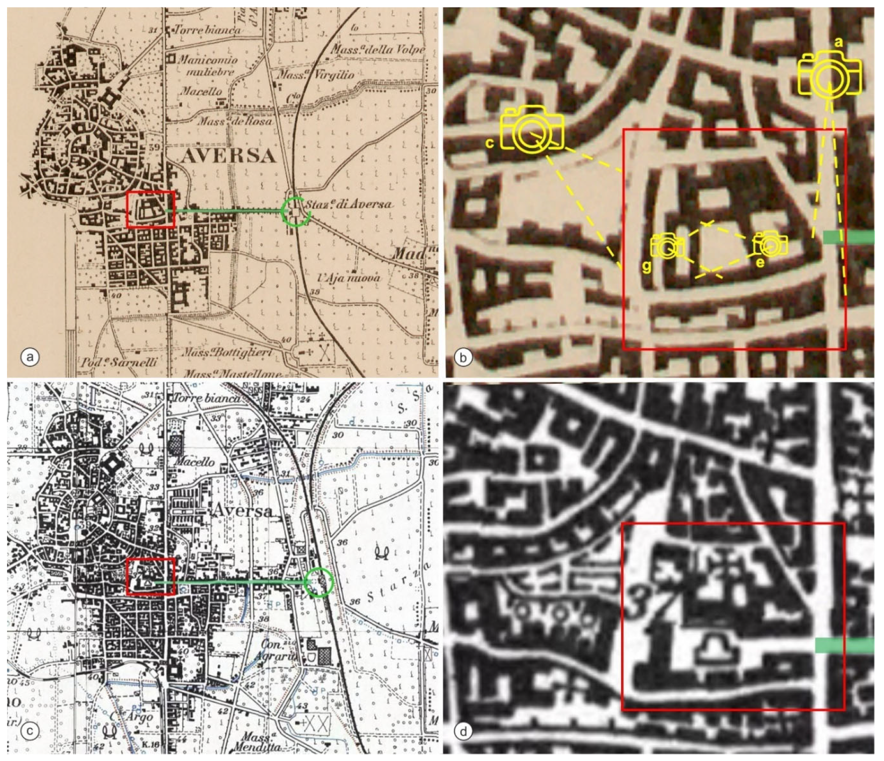
The city of Aversa has had a rich and complex history that has determined various architectural and urban transformations over the centuries (
Figure 1b) [
54,
55]. The historic center still preserves significant traces of the Norman, Angevin and Aragonese eras, with religious and civil buildings of great historical and artistic value. From an urban planning point of view, Aversa has a compact fabric in the historic center, with narrow and winding streets typical of medieval cities, while the more modern areas develop with a more regular and wide road system.
According to proven historical evidence, Aversa developed in the territory where the hamlet of
Sancti Pauli at Averze existed [
56]; however, it was the Normans who founded it in 1030 [
57]. During the Norman period, the city became an important political and military center, with the construction of the castle, which served as a residence and fortification. The territory was characterized by the presence of hedges and ditches. However, it was the increased military strength, the increase in population and the decision to close a section of the ancient road between Capua and Naples (today's Via Roma) that determined, from an urban planning point of view, the transformation of the Angevin city from a radiocentric system to a linear scheme with a substantial expansion of the perimeter walls [
57].
Aversa maintained its strategic importance with the arrival of the Swabians and then the Angevins; the latter marked a period of intense development for the city. The multiplication of religious foundations should also be considered in this sense, which, following alliances concluded with the ecclesiastical apparatus, gave the city a sacred character. Above all, following a weakened predominance of the communities inspired by the rule of Saint Benedict, the city recorded the spread of numerous male and female monasteries, including the complex of San Francesco le Moniche, which was incorporated into the walls after the Angevin expansion of 1382 (
Figure 1c).
The Spanish domination of the Aragonese marks a further urban and architectural renewal of the city. Starting from the end of the sixteenth century, numerous noble palaces and churches were built in the central nucleus of the urban layout, which had the effect of decentralizing the population towards the peripheral areas.
The creation of the “Lemitone” district can be dated back to the early 17th century. It arose on the extreme south-eastern edge of the city, with a plan that follows the pattern of the Spanish quarters of Naples [
58]. The construction of the new district marked the definitive abandonment of the medieval radiocentric plan, giving rise to a quadrilateral-shaped plan within which the area was divided by the orthogonal axes of the communication arteries and cut, in an oblique direction, by a main road [
59].
In the Baroque era, the city was further enriched with elaborate decorations on pre-existing monumental structures. In the 19th century, Aversa experienced further urban expansion with the construction of new streets and squares. The city modernized, while maintaining its historical heritage. In the 20th century, the historic center of Aversa was gradually abandoned, while new residential and commercial areas developed in the surrounding area, as evidenced by the neighborhoods, born in a wild manner, starting from the 1960s in the southern area, to the detriment of a failed recovery of the historic center which, with the exception of some interventions, is in a state of pitiful abandonment.
2.2. The Monumental Complex of San Francesco le Moniche
The Monumental Complex of San Francesco le Moniche originated between 1219 and 1234 [
54]. It was a true monastic citadel measuring approximately 1 hectare. It is the result of building stratifications that began from the date of its foundation, which occurred in the 13
th century, and continued until the 20
th century. The entire citadel was dismembered especially during the Fascist period. In particular, what was originally the garden of the ecclesial complex was transformed into a square and connected directly to the railway station, cutting through the Franciscan insula [
60].
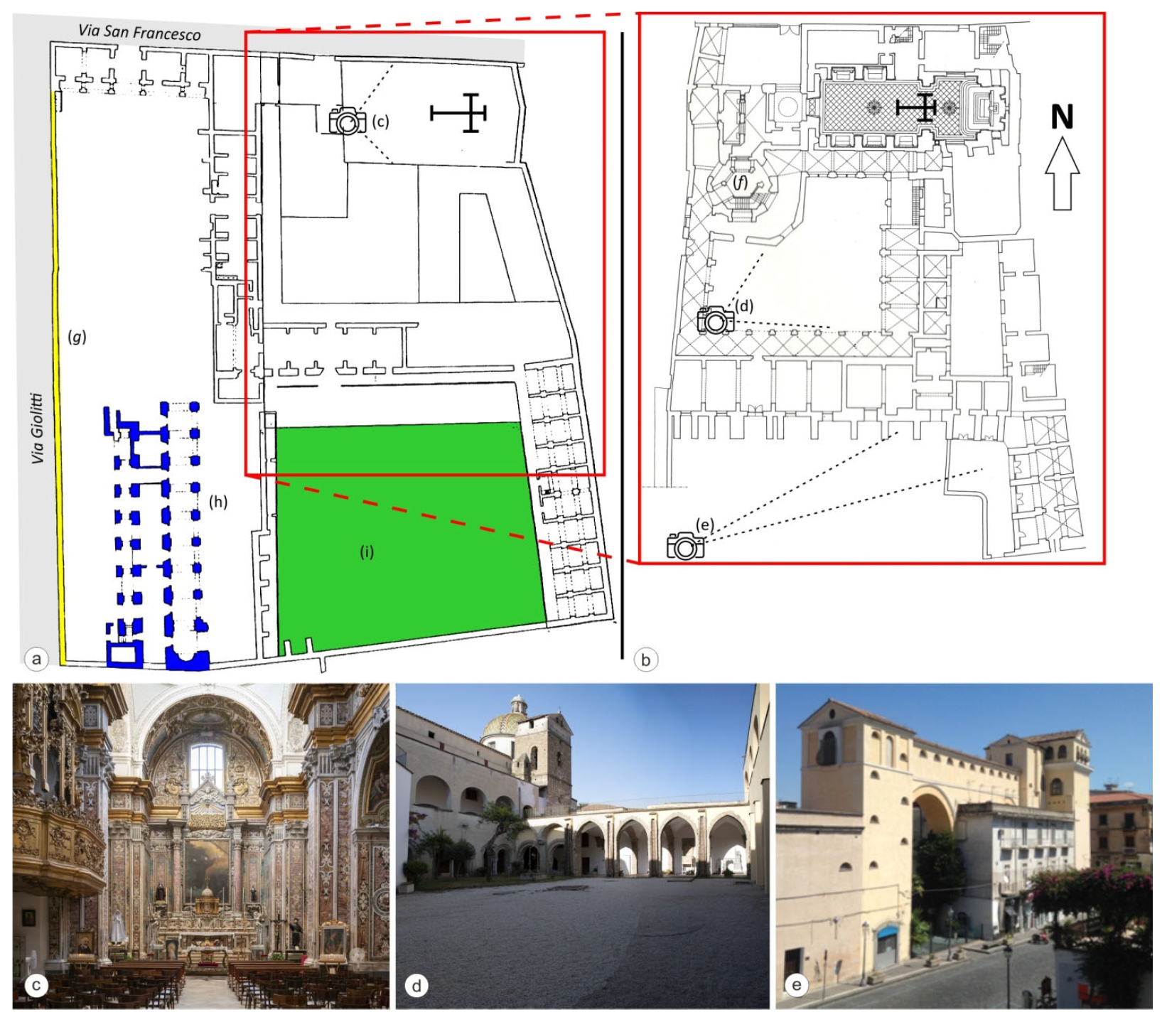
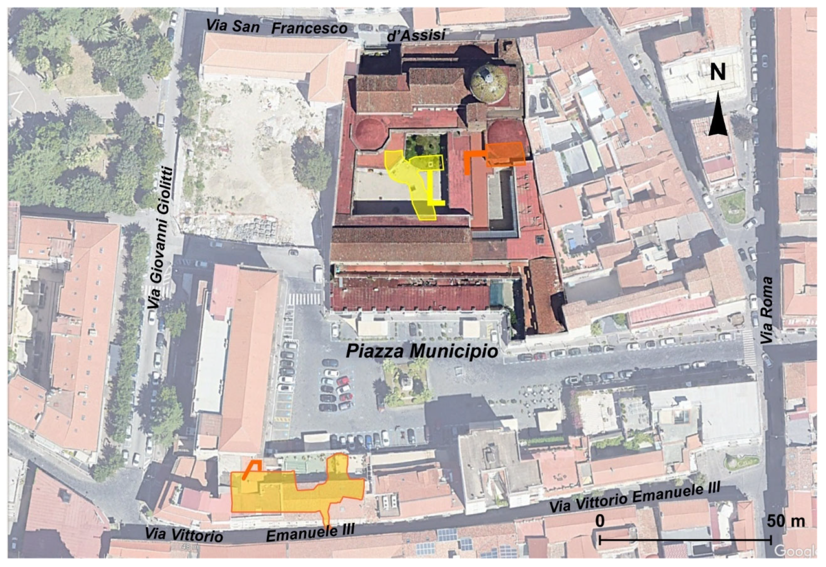
Currently, the monumental complex of San Francesco le Moniche is identified (
Figure 2a,b):
1) in the church, in Baroque style, with a single nave covered by a barrel vault, on the sides of which there are chapels and the sacristy (
Figure 2c); the presbytery is covered by a dome externally covered with colored tiles (
Figure 2d) [
60];
2) in the cloister, which lost its typical medieval rectangular shape (
d in
Figure 2b), with the construction of the octagonal staircase in the north-western corner in the 18th century;
3) in the belvedere (
Figure 2f and
e in
Figure 2b), a building with a complex structural articulation, composed of three climbing structures and a long corridor-gallery. This path culminates in a suspended pathway that leads to the heart of the belvedere, an environment divided into two levels connected by a staircase. This architectural jewel of extraordinary interest, unique in its kind, allowed the nuns a privileged view and participation in the sacred processional rites that took place along the Reggia Strada (now Via Roma) [
61];
4) in the octagonal staircase (
f in
Figure 2b) conceived as an open staircase with a single ramp with an independent static structure. In fact, each change of direction and each portion of the ramp, on a flying buttress, is supported by quadrangular pillars.
On the western side a very high wall enclosed the complex on Via Giolitti (
g in
Figure 2a). The Complex included: Palazzo San Francesco, where the public schools were located (
h in
Figure 2a), the current seat of the City Hall, and a large garden, currently Piazza Municipio (
i in
Figure 2a).
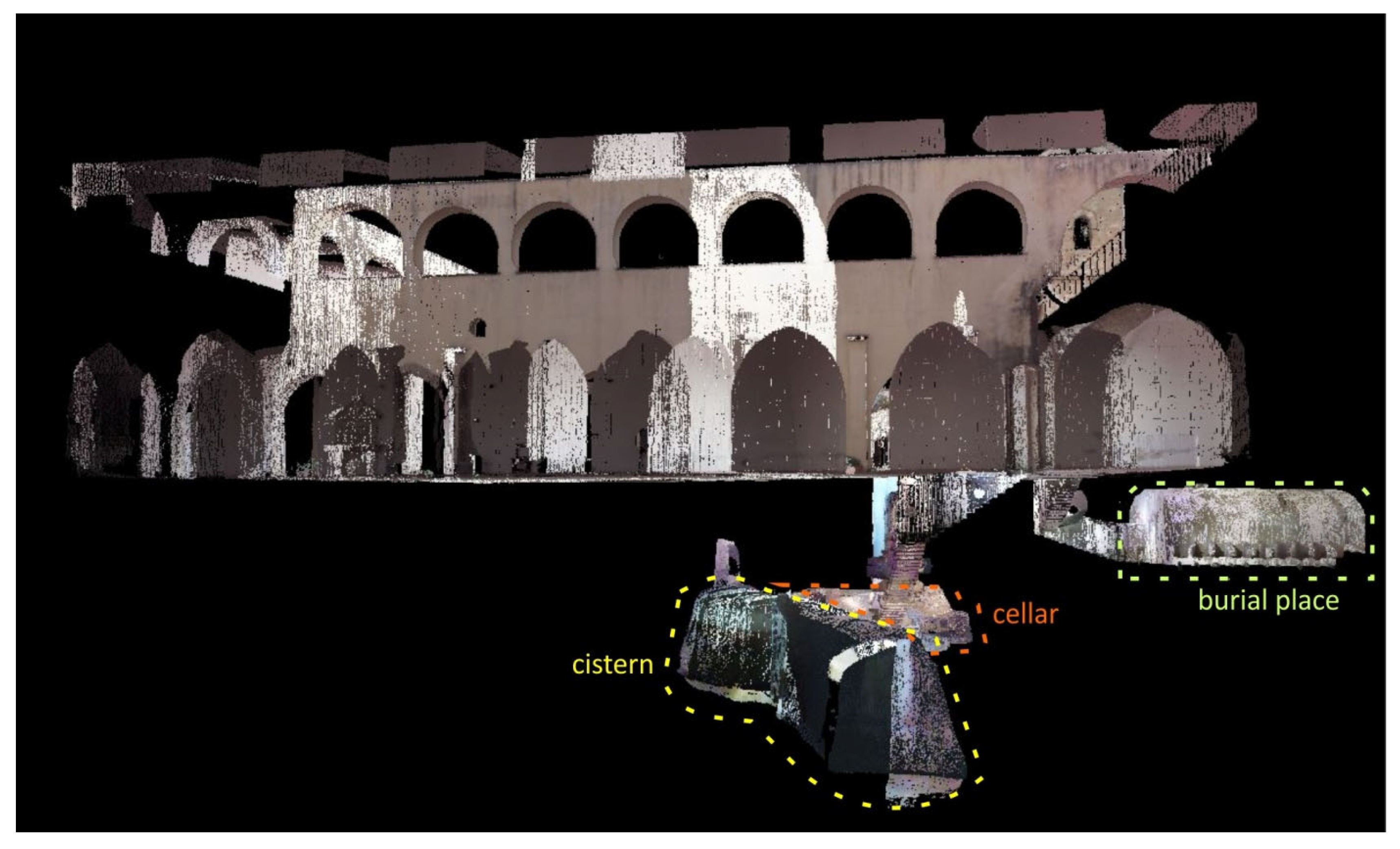
Below the current complex there are several voids: one used as a burial area, one as a cellar and finally a water cistern. Other voids are known on the southern edge of the original garden, while there is no information on the subsoil of the current Piazza Municipio, characterized by frequent deformations of the road pavement.
3. Materials and Methods
3.1. Historical Documents
To describe the evolution of the San Francesco le Moniche Complex, the use of bibliographic data, archival sources, historical cartography and ancient illustrations has proven to be a fundamental pillar for historical, architectural and urban research of the site.
The Topographic Map of Italy, 184 I-NO (AVERSA), in scale 1:25,000, in the editions of 1906, 1936, 1957, was used to highlight the urban transformations that occurred in the first half of the 20th century. The different maps were georeferenced, using the Ground Control Points (GCP) technique as a georeferencing method. This allowed to overlap the maps and therefore to highlight the urban changes.
The combination of bibliographic data with historical cartography was validated in some cases through the use of old illustrations, especially vintage postcards, from the first half of the 20th century.
3.2. Subsoil Characterization
Available boreholes data and geophysical investigations (Multichannel Analysis of Surface Waves, MASW) were used to reconstruct the stratigraphic framework of the subsoils. In particular, the depth of the CGT formation and the thickness of the overlying cohesionless pyroclastic soils were evaluated. This reconstruction constitutes a reference basis for the interpretation of the Electrical Resistivity Tomographic (ERT) survey.
3.2.1. Electrical Resistivity Tomography
The characterization of the subsoil in the study area was achieved by implementing Electrical Resistivity Tomography in the areas surrounding the complex. Given the complexity of the monumental complex, it was suspected that there were other voids in the area. For this reason, to understand the possible presence and the true extent of the cavities, electrical tomography investigations in the areas surrounding the complex have been carried out. Geoelectric surveys represent a modern methodology of non-invasive geophysical investigation and are based on the detection of electrical resistivity of the various types of land investigated. This type of prospecting is the most suitable to localized the presence of cavities.
The survey is conducted by placing on the ground a large number of electrodes connected to an instrument called a Georesistivimeter, system where the soil is fed with a known amount of electrical current. The measurements acquired are processed made by means of special processing software (Res2DINV) allow to obtain a pseudo-section 2D, qualitative representation of the electrostratigraphy of the subsoil. The measurement of changes in these geophysical parameters and their subsequent processing has allowed the geometry and characteristics of geological bodies to be defined, as well as indications on the presence of voids in the subsoil.
3.3. Detection of Underground Cavities Using Laser Scanner
The use of a laser scanner survey in the characterization of an underground cavity has numerous advantages. Laser scanners provide highly precise and accurate measurements of the size and shape of the cavity, allowing the output of three-dimensional models with high spatial resolution and precision in measurements, essential for the detailed characterization of complex underground structures, in a short time, reducing the margin of human error present in traditional topographic survey methods [
62,
63,
64]. The digital models obtained can be used to perform structural analysis, stability of geological structures and risk assessment, improving the planning of interventions and safety measures [
65]; but above all, when the laser scanner survey is georeferenced, it allows an integrated view of the hypogea in relation to the buildings above.
A laser scanner survey of the cavity networks extending beneath the Municipio square on the opposite side of the Monumental Complex of S. Francesco le Moniche in Aversa and below the cloister was performed, using a Leica BLK360 laser scanner.
Leica BLK 360 laser scanner is a particularly suitable instrument for scanning underground premises due to its small size and portability, high scanning speed, 360 degree data acquisition capability and availability of software produced by the same parent company, able of managing large amounts of data with great precision, even when the data comes from different scanning campaigns.
In this work, in fact, the acquisition of point clouds was carried out in different phases, due to the different logistical conditions faced in the underground environments, one of which consisting of a water collection cistern. In all acquisitions it was possible to carry out the survey without target positioning, thanks to the redundant number of performed scans and the high precision of the used instrumentation.
In the processing phase, were assembled 19 scans in the case of the cavities beneath the San Francesco le Moniche Complex and 18 scans in the case of the cavity beneath Municipio square; in both cases some scans were performed up to the surface, to connect the structures present in the subsoil to the historical buildings on the surface, obtaining single three-dimensional models.
4. Results and Discussion
4.1. Subsoil and Cavities
The stratigraphic framework of the subsoil has been reconstructed using literature data and borehole stratigraphies from neighboring areas. The first 4-5 m from the ground level are characterized by loose pyroclastic deposits, deriving from eruptions subsequent to the emplacement of the CGT, which instead characterizes the underlying levels with the zeolitized yellow facies. The contact between the two units is marked by a thin layer of “cappellaccio”, representing the upper portion of the lithoid tuff formation (CGT) altered in subaerial environment.
This marked distinction in lithologies allows for easy reading of the indirect geophysical investigations (ERT) carried out to identify any other voids in the subsoil of the monumental complex.
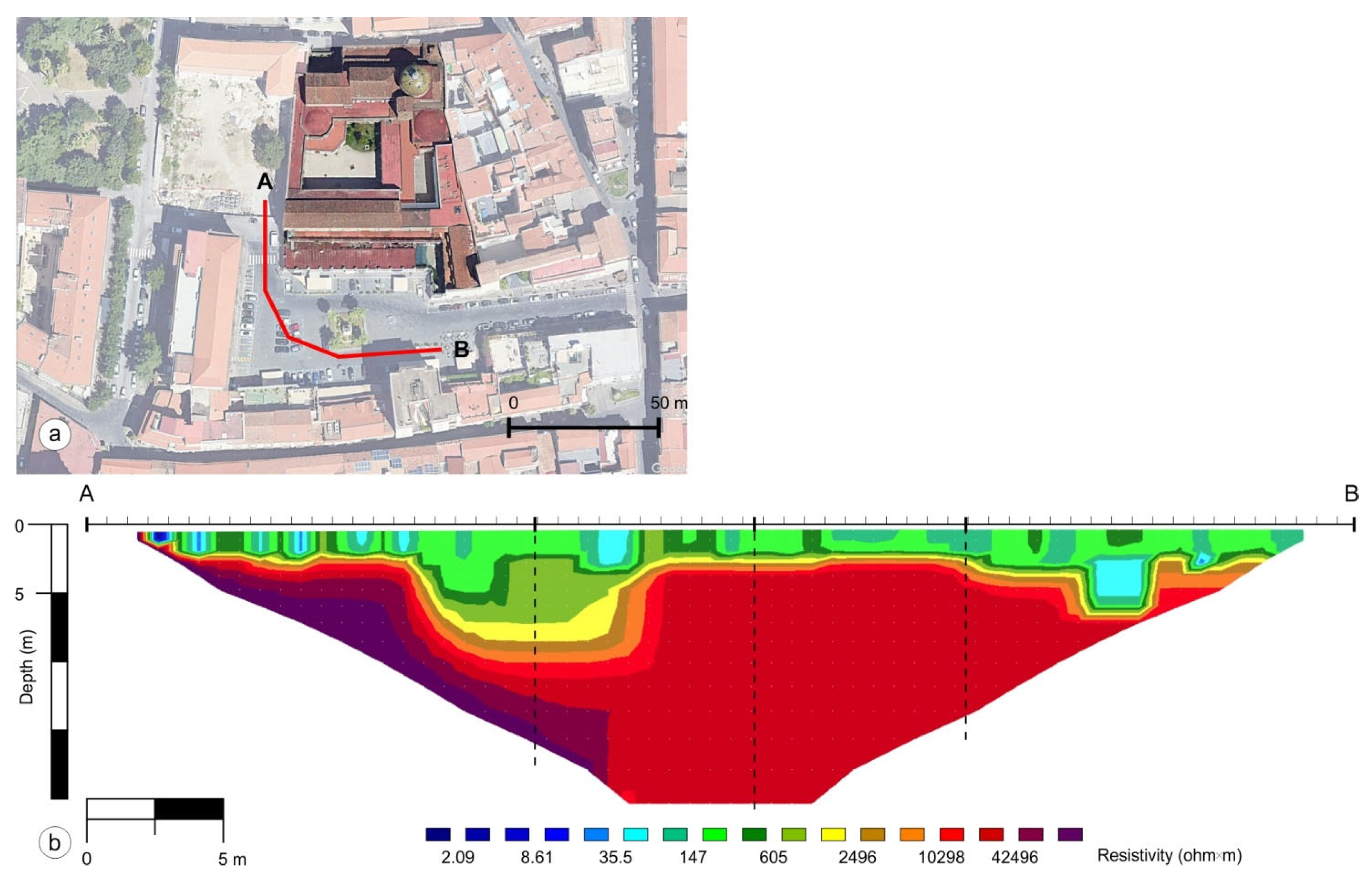
The data acquired during the ERT survey have been processed and the result obtained is a section (
Figure 3) that shows the 2D distribution of the electrical resistivity of the soil investigated. From the analysis and interpretation of the above section it was possible to detect the presence of two main electrostrates:
a more conductive surface layer varying in thickness between 3.00 m and about 3.50 m, associated with sandy soils, sandy-loam humidified and very aerated, little thickened.
a more resistive underlying layer associated with sandy and sandy loamy soils in the upper part of the section, while in the lower part associated with the tuffaceous formation.
In the section, in particular, there is an area colored in blue at about 3 m of depth characterized by an anomaly of electrical resistivity, with low values of resistivity, presumably attributable to a ductwork used as a sewer duct, judging by the size and shape. While in the section overlooking the town hall, there is a large depressed area, filled with material clearly reworked as derived from the values of resistivity obtained. Moreover, what has aroused the greatest perplexity is the considerable increase in the electrical resistivity of the values in the lower left portion of the section (adjacent to the perimeter wall of the cloister), attributable to the presence of an underground void.
4.2. The Monumental Complex of San Francesco le Moniche
The monastic complex and the surrounding area are the result of continuous transformations that occurred following numerous architectural, structural and urban interventions over the centuries, with modifications that continued until the first half of the twentieth century.
From an architectural point of view, the first significant alterations to the original Romanesque-Gothic structure occurred at the end of the 17th century. During this period, in response to the indications of the Counter-Reformation, the convent was adapted and expanded. One of the most important interventions was the construction of the large cloister, which represented not only a spatial expansion but also a functional transformation of the entire complex.
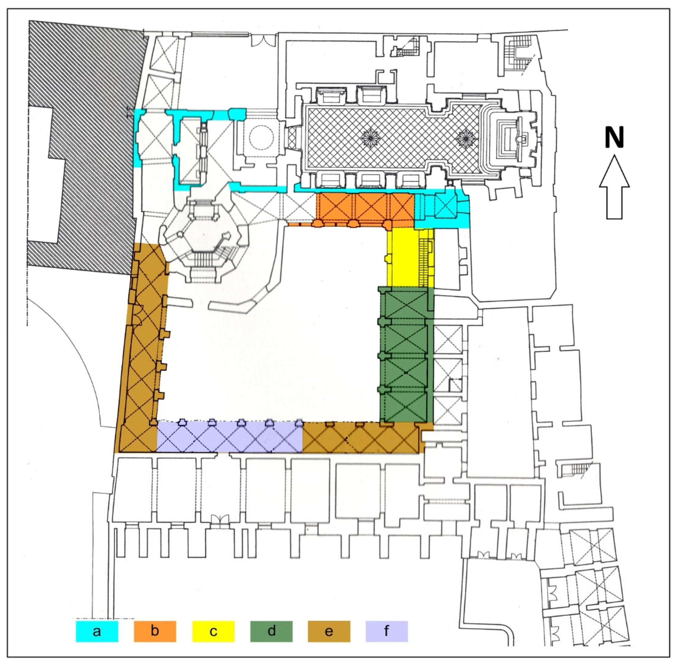
The construction of the cloister began in the Late Romanesque period and was completed in the 13th century (
Figure 4).
The northern ambulatory was initially composed of seven spans, of which the first three, to the west, were demolished to make way for the octagonal staircase (
Figure 4). The four surviving spans are covered by round cross vaults, punctuated by transverse arches and pilasters leaning against the wall. On the external side, towards the ancient garden, there are three arched mullioned windows with double architraves, with twin columns.
The eastern arm of the cloister was built in two phases. The first two modules to the north date back to the late thirteenth century, covered by cross vaults without separating arches. These spans open onto the cloister via round arches with double architraves. The remaining part of the eastern arm is composed of four fourteenth-century spans, covered by pointed cross vaults, interspersed with eighteenth-century tuff reinforcement arches.
The two arms to the south and west have different modules and rhythms, connecting "badly" to each other and to the northern ambulatory. The external arches and the cross vaults are pointed, with "T" shaped pillars and contrasting pilasters. In 1997, the five western bays collapsed due to abandonment and neglect, causing the loss of frescoes and Romanesque decorations, and were rebuilt according to the principle of stylistic restoration.
The 18th century saw the beginning of the construction of the octagonal staircase which was to serve as access to the summer choir (an area where the Poor Clares, during the summer months, attended religious services without a view). However, this construction remained incomplete. In the 19th century, further modifications were made with the creation of the belvedere. These interventions further modified the original configuration which culminated with the promulgation of the laws on the suppression of monasteries which led to significant transformations in the architecture and use of the spaces of the complex. These changes culminated in the twentieth century with interventions that profoundly altered the original layout of the monastic citadel.
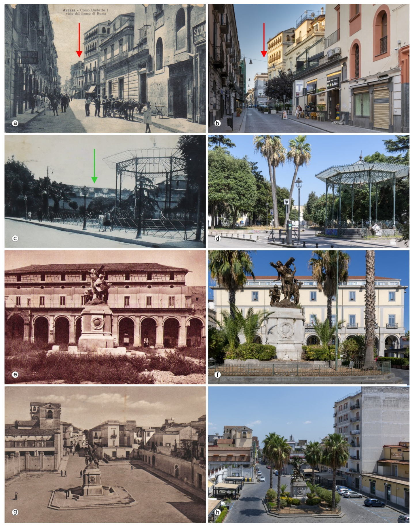
Since 1914, the area of the Complex and its surroundings have been the subject of study for an urban planning intervention that included a large program of road development. In particular, one intervention contemplated the connection between Strada Garibaldi with Viale Giolitti by means of the demolition of the Franciscan insula, consisting in the demolition of convent structures and private buildings, and the crossing of the monastery (
Figure 5a,b;
Figure 6). In this way, the railway station, located to the east of the municipal territory, was connected to the city center where the new municipal headquarters was planned and an area suitable for hosting the monument to the fallen of the Great War (
Figure 5e-h), financed with a public subscription [
66], in one of the cloisters of the ancient convent that was once attached to the monastery. During the same period the perimeter wall on the western side was demolished (g in
Figure 2a,
Figure 5 c-d). All this represented the first major urban planning intervention since the post-unification era that was completed only in 1940 [
61].
4.3. The Cavities below the Monumental Complex
The underground cavities, developed for many centuries in the subsoil of the Neapolitan area and the northern Campania, represent above all original sites of extraction of tuff and loose pyroclastic materials, and were subsequently used for other purposes. The methods of extraction and use of the extracted materials can provide important information on the history of a building or a residential settlement.
The qualification of the building heritage, over time, has in fact been directed towards the recognition of the building stratifications [
67]. For each building, the complexities of the construction phases are recognized, with analytical methods specific to the natural sciences. A particular research has deepened the study of the construction techniques of the masonry works made in tuff from the post-Middle Ages onwards in the territory of Naples and northern Campania. The possibility of dating the building stratifications contributes to the qualification of a particular building civilization, otherwise historically indistinct, thus giving it a specific historical individuality and, consequently, a cultural qualification.
In the specific case of tuff walls, of particular interest is the observation of the techniques used to create the internal blocks [
67,
68,
69], extracted from the subsoil through the creation of underground excavations carried out in correspondence with the courtyards or gardens. In the most superficial incoherent layers, the aggregates necessary for making the mortars were found (sands, pumice, lapilli, "pozzolane" - pulvis puteolanus; [
70,
71].
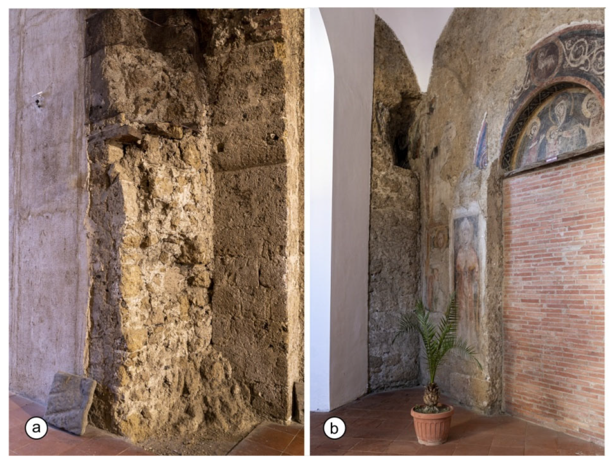
Initially,the walls were built using the “a cantieri” technique, that is, with extracted, split material of heterogeneous size and stacked without paying excessive attention to the horizontal position, bound with mortar. Since the 18th century, instead, recourse was made to rows of “bozzette”, that is, rough-hewn stones with differentiated size and arranged in horizontal rows. From the first decades of the 19th century, the masonry work with rows of “blocchetti”, squared and flattened blocks, with dry masonry mass, became popular, adopted until about the middle of the 20th century [
68,
72,
73,
74].
In the absence of certain historical evidence, we can propose a chronological reading of some structures based merely on the masonry works and of construction techniques of the San Francesco complex. This allows to recognize the stratification through the shape and arrangement of the tuff blocks. The masonry in “a cantieri” technique (
Figure 7a), in which the resources and techniques were less sophisticated than in subsequent periods, dates back to the first phase of construction of the church (late 12th century). It is recognizable in the use of irregularly shaped tuff stones, arranged randomly and bound with mortar, creating an irregular but resistant structure. Inside the Complex, masonry of the “bozzette” type is also recognizable (
Figure 7b) which shows the use of squared and regular blocks, arranged in horizontal courses, which gave solidity and durability to the structure; one can notice the use of stones of different sizes for the construction of the church and the ambulatory adjacent to it and this indicates a different periodization of the construction phases.
The material constituting the masonry works observable in the complex probably comes from the cavities present in the subsoil of the entire structure, even in those portions now inserted into the urban fabric with the modifications of the early 1900s. The shape and size of the cavities and their spatial distribution can then help to hypothesize a possible temporal interpretation as well.
Given the extension and complexity of the entire monumental complex, the search for other underground hypogea is very complicated. From information handed down for generations, the presence of hypogea under the buildings surrounding Piazza Municipio is known, even if, in recent times, many have been covered over and their extension and position are no longer identifiable. Only one cavity located under a building adjacent to the town hall is accessible. The results of the ERT investigations suggest the presence of a void under the rooms outside the cloister. Finally, inside the latter, three different cavities are known, accessible and explorable.
The survey carried out in the few accessible cavities, however, has provided interesting hints for thought and reading of all the elements exposed so far. The following paragraphs will provide details of the surveys carried out.
4.3.1. Piazza Municipio
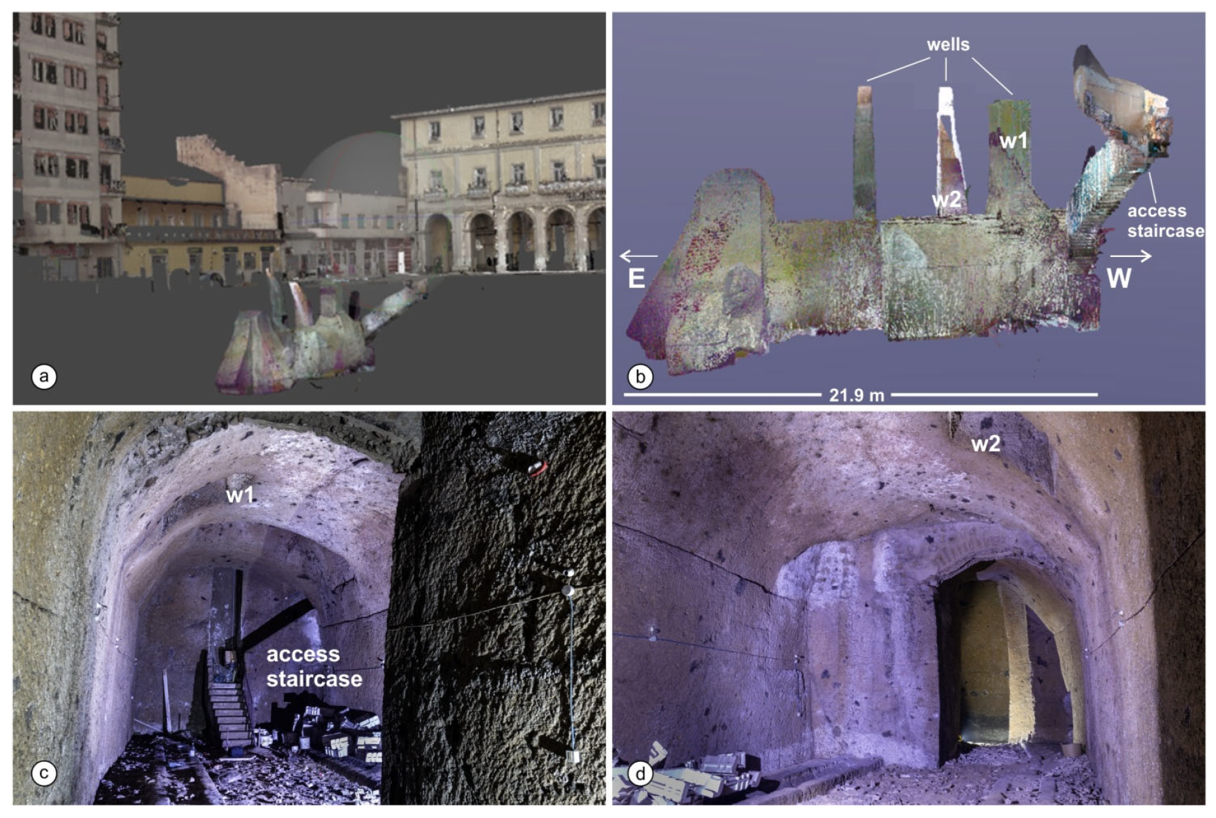
The cavity is accessed via a long staircase dug into the tuff, from inside a bar located along the southern side of Piazza Municipio (
Figure 9a) and extends below the building that represented the edge of the original garden. Over time, the cavity has been used for the production and conservation of wine and was probably connected to a more complex underground system which extended towards the historic center of the city of Aversa.
The staircase initially proceeds towards the west and then bends at approximately 90° towards the south to enter the cavity at its short western side. The cavity is polygonal shaped, roughly rectilinear in plan in the E-W direction (
Figure 9b), The overall length is 21.9 m, the average width is 6.6 m. It can be divided into two sectors (
Figure 9c,d): the first, 12.7 long is separated by a more restricted space (about 6 m long) from another smaller room, more irregular in shape. The height of the cavity is approximately 6 m, with the exception of the sector opposite the access staircase, where it reaches 9.4 m. The vault has a low arch profile; 2 square section wells (l = 1 m) start from the vault and are closed by an iron grate and overlook the external wall of the building on via V. Emanuele III; another 2 wells, one of which is approximately 2 m large, are closed at the top end by a grate and masonry works.
The architecture of this cavity, very similar to those present in a large part of the city's subsoil, suggests an original quarry for extracting material to be used for construction. Subsequently, the cavity, developed beneath structures that surrounded the original garden of the complex, was reused as cellar for storing foodstuffs and wine [
40]. The latter use is still very common as the physical characteristics of the tuff favor the fermentation of the musts ensuring temperature values and humidity constant in underground environments. Of particular interest is the production of a vine typical only of this area, the “
asprinio”, of millenary origins and whose production has become so important in the last decade as to require to recognition as a UNESCO heritage.
4.3.2. Cloister
On the eastern side of the courtyard, from the cloister floor level, a rectangular door oriented east-west opens (
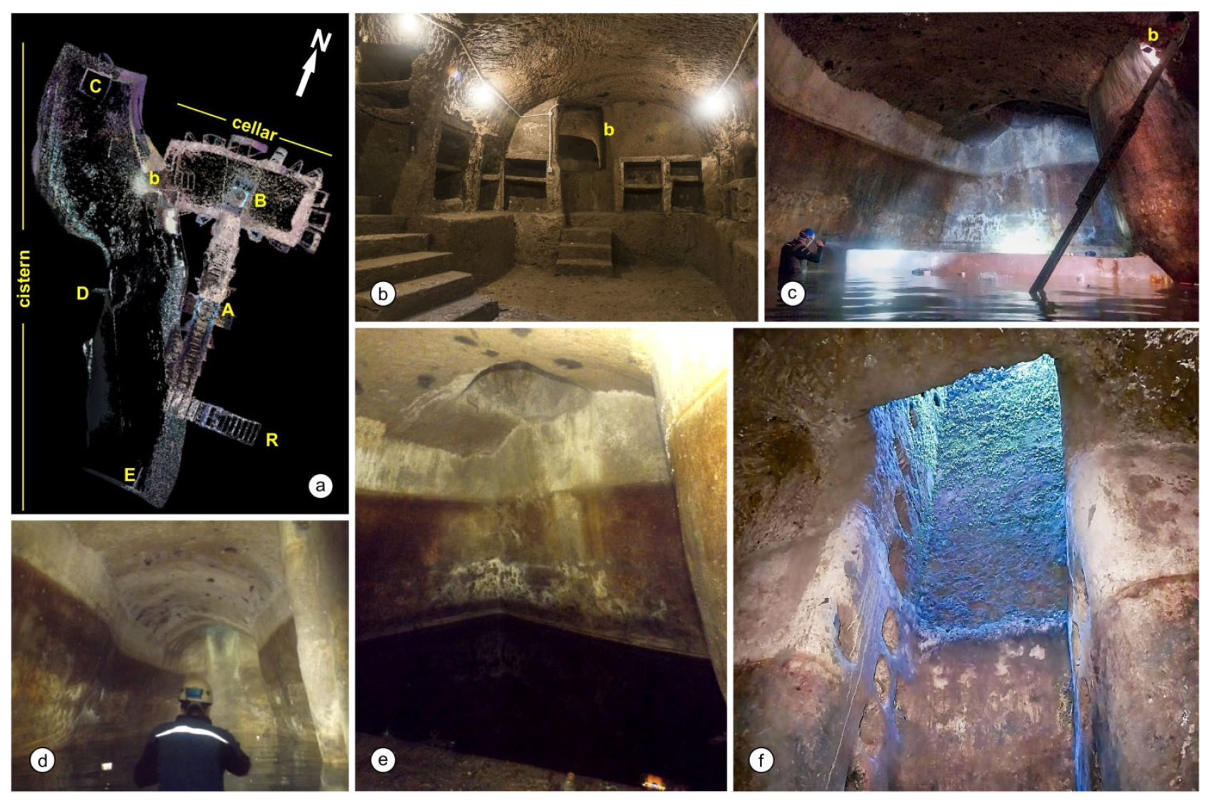
Figure 10, R); from this a tuff staircase extends for approximately 11 m until reaching a hypogeal room (
Figure 11).
This has a rectangular plan, 7.5 m x 3 m, 2.7 m high, with a vault at -5.9 m from the ground level (
Figure 11a). Both the ramp and the underground room, dug into the tuff rock, are characterised by the presence of brick shelves which, like shelves, are hypothetically functional for the conservation of food supplies. This room has been recognised as a cellar serving the convent structure (
Figure 11b). The presence of traces of modern cement, poorly preserved and used to reinforce old shelves, would testify to the use of the room at least until the first half of the 20th century, but the chronological identification of its original layout remains controversial.
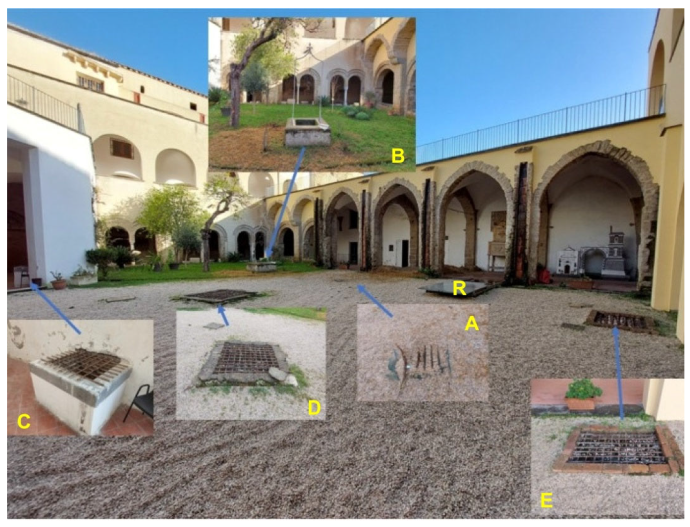
The second section of the access ramp to the cellar, oriented north-south, intercepts a circular well recognisable from the floor of the internal courtyard (
Figure 10, well A); another well is finally clearly identifiable in the centre of the vault of the cellar and is evidenced, on the surface, by the presence of a "decorative" well in the northern part of the courtyard (
Figure 10, well B).
An important structural element, which could help highlighting the temporal and functional relationships between the underground rooms and the surface system, is the presence of a break through the western wall of the cellar, made at a later time, which leads directly into a large underground room whose floor is located at a level approximately 3-4 m lower than that of the cellar (
Figure 11b, 11c). This large room has approximately 1.5 m of rainwater at the bottom which, together with the hydraulic plaster recognisable on all the walls, allows the hypogeum to be identified as a large cistern; the hydraulic plaster, in fact, is well preserved for approximately 4 m of the vertical development of the walls, i.e. almost up to the impost abutment of the ceiling which, on the contrary, is left as rough rock without any wall facing. Furthermore, during the exploration of the bottom, the walls appeared particularly overhanging and this characteristic was well confirmed by the development of the topographic survey which returned trapezoidal-shaped cross-sections.
The cistern is approximately 20 m long and 5.5 m wide, and has a very low arched ceiling, approximately 5.5 m high from the bottom (
Figure 11d). Of particular interest is the sigmoid-shaped plan of the cistern, which extends in the centre of the cloister courtyard with a NW-SE orientation (
Figure 11a). The northern side of the cistern is characterised by the presence of a large rectangular basin (
Figure 11e), delimited by a wall partition approximately 1.5 m high, presumably used for the sedimentation of silt suspended in the water. The cistern, like the cellar and the access ramp, is equipped with three rectangular light wells, closed on the surface by an iron grate. The northernmost of these, located right on the aforementioned internal basin, connects to the octagonal staircase pertaining to the eighteenth-century phase of the quadriportico (
Figure 10, well C), and is characterised here by the presence of a low parapet. The other two emerge into the internal courtyard right along the development line of the cistern; in the central well (
Figure 10, well D) the grappiate can be recognised along the entire vertical development of two walls: they are holes dug into the tuff, which allowed people to go up and down into these underground environments, evidence of an original service access to the cistern (
Figure 11f). Finally, there is the last well (
Figure 10, well E), positioned to the south-east at the edge of the perimeter of the cistern, this does not have grappiate and seems to have the sole function of a light well.
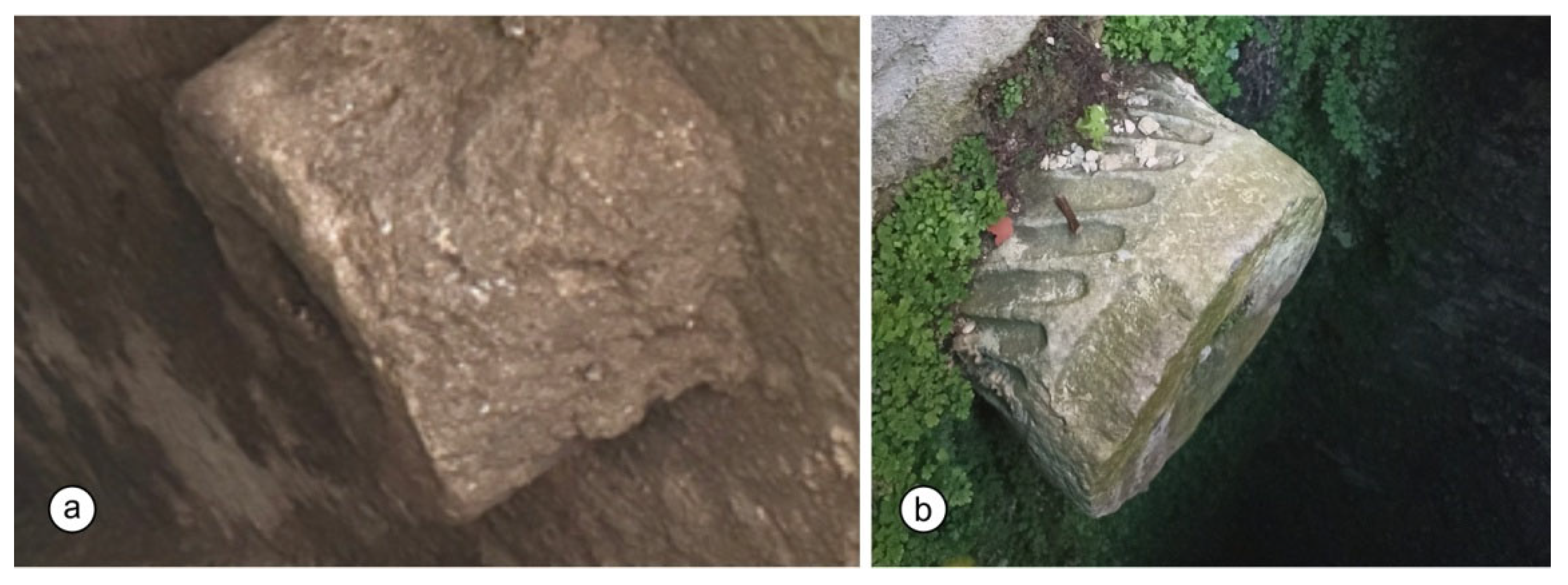
Inside wells C and E, at a depth of about 50 cm, some columns can be seen protruding perpendicularly to the well (
Figure 12), one of which is twisted (helical columns; well E,
Figure 12b): they are not only a decorative element but, perforated along their entire length, they were used as water pipes, in order to channel rainwater towards the underground cistern, thus ensuring a constant water supply for the religious community. The age of the columns, probably from the Roman era, is certainly much older than the convent itself: starting with the Normans in the 11th century, but also during the Middle Ages and the Renaissance, many materials and structures from the Roman era were reused for new buildings. In Aversa, numerous examples of spoliation can be found: columns, capitals, and other architectural elements of Roman origin are integrated into later buildings, both religious and civil.
The convent also has a third hypogeum (
Figure 13): a burial place, putridarium (also known as the draining room – “
scolatoio” - of the dead). From the floor of the eastern cloister, a ramp with low steps leads to a large underground room with a rectangular plan. This room, covered by a barrel vault, is characterised by the presence of ten mortuary seats on both long sides and has dimensions of 10 m x 6 m and is approximately between 3.8 and 4.3 m high. All the walls and the ceiling of the burial place are smoothed by the presence of a layer of light plaster; on the back wall in front of the entrance a faint frescoed crucifix survives.
The three hypogea described so far seem to document different chronological interventions pertaining to at least two different architectural phases. The cistern, located at a greater height/depth (
Figure 14), could correspond to the first settlement phases and be functional for collecting water for the monastic community. The cellar, on the other hand, would appear to be later than the cistern; the discriminating element for this relative chronology is the opening of a passage from the west wall of the cellar on the northern side of the cistern; this passage clearly destroys part of the waterproofing plaster of the cistern (
Figure 11c). The
putridarium, or draining room, has no architectural relation with the two cavities described above; although it is difficult to date, the chronological context could be identified between the 13th and 15th centuries, that is, between the oldest phase of the convent structure, to which the cloister and bell tower are dated [
60], and the first Renaissance phase.
5. Summary and Conclusions
In this study, the cultural heritage of the monumental complex of San Francesco le Moniche and the additional value associated with the natural heritage (i.e. geological and geomorphological context, building stones) have been linked. The history of the monumental area is very complex and is represented by a temporal stratification of interventions over the centuries, known from bibliographic sources and documented by one of the Authors in a study on the paintings present inside it [
60]. This history is intertwined with the construction materials and the techniques of both extraction and working and use of the same. Therefore, the techniques of construction of the tuff walls, recognizable in various parts of the monument, and the cavities in the subsoil, presumably originally extraction quarries and subsequently reused for the life of the nuns, assume documentary value.
The monumental complex is not included in a UNESCO World Heritage list but represents one of the cornerstones of the history of an ancient Norman county (i.e. Aversa) that narrates a thousand-year-old history that is also based on the geomorphological and geological context on which it arose. Many sites in the world, included in the above list, are known above all for their cultural value, even if they contain interesting landforms and rock outcrops [
75], whose consideration could significantly improve the knowledge of the history of these sites.
The example reported herein, far from being exhaustive, offers evidence of a geoheritage-cultural heritage interface whose reading adds value for educational and urban geotourism purpose, being the latter an emerging sector of sustainable tourism [
76,
77]. The results allowed us to improve the knowledge of the study site and provide useful tools for the planning of future targeted investigations.
Author Contributions
Conceptualization, D.R. and M. V.; methodology, D.R., M.V., PM.G., I.G., MA.F.; software, M.V., PM.G.; validation, D.R, M.V.; formal analysis, PM.G., I.G., MA.F.; investigation, M.V., MA.F., PM.G., I.G., A.P.; resources, D.R.; data curation, M.V.; writing—original draft preparation, D.R., M.V., A.P., I.G., PM.G., MA.F..; writing—review and editing, D.R., M.V.; visualization, X.X.; supervision, D.R., M.V. All authors have read and agreed to the published version of the manuscript.
Funding
The research activities were funded to D.R. by the Collaboration Research Program on "Census, analysis and evaluation of the Cavity System" present in the territory of the Hydrographic District of the Southern Apennines (Italy).
Data Availability Statement
The data used in this research work are available upon request from the corresponding authors.
Acknowledgments
The authors thank the association Amici di San Francesco for their collaboration in the surveys in the cavities and the inspections in the monumental complex. Special thanks to Mons. Pasquale De Cristofaro (Rector of the Monumental Complex of San Francesco).
Conflicts of Interest
The authors declare no conflicts of interest. The funders had no role in the design of the study; in the collection, analyses, or interpretation of data; in the writing of the manuscript; or in the decision to publish the results.
References
- Brockx, M.; Semeniuk, V. Geoheritage and geoconservation—History, definition, scope and scale. Journal of the Royal Society of Western Australia 2007, 90, 53–87. [Google Scholar]
- Pijet-Migoń, E.; Migoń, P. Geoheritage and Cultural Heritage—A Review of Recurrent and Interlinked Themes. Geosciences 2022, 12, 98. [Google Scholar] [CrossRef]
- Bollati, I. M.; Caironi, V.; Gallo, A.; Muccignato, E.; Pelfini, M.; Bagnati, T. How to integrate cultural and geological heritage? The case of the Comuniterrae project (Sesia Val Grande UNESCO Global Geopark, northern Italy). AUC Geographica 2023, 58, 129–145. [Google Scholar] [CrossRef]
- De Wever, P.; Baudin, F.; Pereira, D.; Cornée, A.; Egoroff, G.; Page, K. The importance of geosites and heritage stones in cities—A review. Geoheritage 2017, 9, 561–575. [Google Scholar] [CrossRef]
- López-García, J.A.; Oyarzun, R.; López Andrés, S.; Manteca Martínez, J.I. Scientific, educational, and environmental considerations regarding mine sites and geoheritage: A perspective from SE Spain. Geoheritage 2011, 3, 267–275. [Google Scholar] [CrossRef]
- Del Lama, E.A. Potential for urban geotourism: Churches and cemeteries. Geoheritage 2019, 11, 717–728. [Google Scholar] [CrossRef]
- Pereira, L.S.; do Nascimento, M.A.L.; Mantesso-Neto, V. Geotouristic trail in the Senhor da Boa Sentenca Cemetery, Jo.o Pessoa, State of Paraíba (PB), Northeastern Brazil. Geoheritage 2019, 11, 1133–1149. [Google Scholar] [CrossRef]
- Prosser, C.D. Geoconservation, quarrying and mining: Opportunities and challenges illustrated through working in partnership with the mineral extraction industry in England. Geoheritage 2018, 10, 259–270. [Google Scholar] [CrossRef]
- Del Prete, S.; Galeazzi, C.; Germani, C.; Martimucci, V.; Parise, M. Geohydrological Problems Related to Underground Artificial Cavities. In Proceedings of the Convegni Lincei “Frane e Dissesto Idrogeologico: Consuntivo”; Accademia dei Lincei: Rome, Italy, 201.
- Parise, M.; Lollino, P. A Preliminary Analysis of Failure Mechanisms in Karst and Man-Made Underground Caves in Southern Italy. Geomorphology 2011, 134, 132–143. [Google Scholar] [CrossRef]
- Parise, M. A present risk from past activities: Sinkhole occurrence above underground quarries. Carbonates Evaporites 2012, 27, 109–118. [Google Scholar] [CrossRef]
- Parise, M. Engineering-geological studies in artificial cavities, aimed at evaluating the possibility of failures in underground settings. In Proceedings of the Congress in Artificial Cavities “Hypogea 2017”, Cappadocia, Turkey, 6 March 2017. [Google Scholar]
- Vennari, C.; Parise, M. A Chronological Database about Natural and Anthropogenic Sinkholes in Italy. Geosciences 2022, 12, 200. [Google Scholar] [CrossRef]
- Galeazzi, C. The Typological Tree of Artificial Cavities: A Contribution by the Commission of the Italian Speleological Society. Opera Ipogea-J. Speleol. Artif. Cavities 2013, 1, 9–18. [Google Scholar]
- Parise, M.; Galeazzi, C.; Bixio, R.; Dixon, M. Classification of Artificial Cavities: A First Contribution by the UIS Commission. In Proceedings of the 16th International Congress of Speleology, Brno, Czech Republic, 21–28 July 2013; Filippi, M., Lollino, P., Eds.; pp. 230–235.
- Gordon, J.E. Geotourism and cultural heritage. In Handbook of Geotourism; Dowling, R., Newsome, D., Eds.; Edward Elgar: Cheltenham, UK, 2018; pp. 61–75. [Google Scholar]
- Crisman, P. Documenting Historical Architecture: The Importance of Bibliography and Archival Research. Architectural Research Quarterly 2013, 17, 253–267. [Google Scholar]
- Fairclough, G. New Heritage, An Introductory Essay – People, Landscape and Change. Landscape Research 2009, 34, 7–26. [Google Scholar]
- Mingione, E.; Ruberti, D.; Strumia, S.; Vigliotti, M. Cartografia storica e sistemi GIS per lo studio dell’evoluzione dei caratteri fisici ed antropici del territorio. Il caso di Capua (CE). Il Quaternario, Italian Journal of Quaternary Science 2004, 17, 629–642. [Google Scholar]
- Ruberti, D.; Vigliotti, M.; Di Mauro, A.; Chieffi, R.; Di Natale, M. Human influence over 150 years of coastal evolution in the Volturno delta system (southern Italy). Journal of Coastal Conservation 2018, 22, 897–917. [Google Scholar] [CrossRef]
- Edney, M. H. Theory and the History of Cartography. Imago Mundi, 1996, 48, 185–191. [Google Scholar] [CrossRef]
- Harley, J. B.; Woodward, D. (Eds.) The History of Cartography, Volume 1: Cartography in Prehistoric, Ancient, and Medieval Europe and the Mediterranean. University of Chicago Press 1987.
- Gislason, G. The Use of Historical Maps in the Study of Long-Term Landscape Change: A Case Study of the Oulu Region, Northern Finland. Fennia - International Journal of Geography 2011, 189, 32–47. [Google Scholar]
- Lane, B. M. Architectural Restoration: Criteria and Guidelines for Historic Building Preservation. Journal of Architectural Conservation 1996, 2, 7–26. [Google Scholar]
- Kostof, S. The City Shaped: Urban Patterns and Meanings Through History. Bulfinch Press. 1992.
- Green, D. From Sketch to Structure: The Role of Architectural Drawings in the Preservation of Historical Buildings. Journal of the Society of Architectural Historians 1996, 55, 414–439. [Google Scholar]
- Hill, J.; Kohane, P. The Use of Historical Imagery in Understanding the Transformation of Urban Spaces. Planning Perspectives 2001, 16, 247–267. [Google Scholar]
- Gruber, A. Depicting Change: The Use of Historical Photographs in Architectural Heritage Research. Architectural Heritage 2008, 19, 65–80. [Google Scholar]
- Migon, P. Geoheritage and World Heritage sites. In Geoheritage. Assessment, Protection, and Management; Reynard, E., Brilha, J., Eds.; Elsevier: Amsterdam, The Netherlands, 2018; pp. 237–249. [Google Scholar]
- Gray, M. Geodiversity, geoheritage and geoconservation for society. Int. J. Geoheritage Parks 2019, 7, 226–236. [Google Scholar] [CrossRef]
- Ebanista, C. L’utilizzo Cultuale Delle Grotte Campane nel Medioevo, in Campania Speleologica; I Convegno Regionale di Speleologia: Oliveto Citra, Italy, 2007. [Google Scholar]
- Ebanista, C. Abitati e luoghi di culto rupestri in Campania e Molise. In Le Aree Rupestri Dell’italia Centro・Meridionale, Nell’ambito Delle Civiltà italiche: Conoscenza, Salvaguardia, Tutela. IV Convegno Internazionale Sulla Civiltà Rupestre, Savelletri di Fasano, Italy, 17 November 2011; Menesto, E., Ed.; Cisam: Spoleto, Italy, 2011. [Google Scholar]
- Palmer, A. Cave Geology; Cave Books: Dayton, OH, USA, 2007; pp. 1–456. [Google Scholar]
- Parise, M. Il Progetto “La Carta degli Antichi Acquedotti Italiani”. Opera Ipogea 2007, 1, 3–16. [Google Scholar]
- Parise, M. Distribution and characteristics of ancient underground aqueducts in Italy. In Proceedings of the IWA Specialty Conference, 2nd International Symposium “Water andWastewater Technologies in Ancient Civilizations”, Bari, Italy, 28 May 2009. [Google Scholar]
- Parise, M. Lo sviluppo degli insediamenti rupestri in funzione delle caratteristiche fisiografiche del territorio. In Proceedings of the Seminario Internazionale CRHIMA “Rupestrian Settlements in the Mediterranean Region”, Massafra, Italy, 28 April 2011. [Google Scholar]
- Varriale, R.; Parise, M.; Genovese, L.; Leo, M.; Valese, S. Underground Built Heritage in Naples: From Knowledge to Monitoring and Enhancement. In Handbook of Cultural Heritage Analysis; D’Amico, S., Venuti, V., Eds.; Springer: Cham, The Netherland, 2022. [Google Scholar] [CrossRef]
- Del Prete, S.; Parise, M. An overview of the geological and morphological constraints in the excavation of artificial cavities. In Proceedings of the 16th International Congress of Speleology, Brno, Czech Republic, 21–28 July 2013. [Google Scholar]
- Damiano, E.; Fabozzi, M.A.; Guarino, P.M.; Molitierno, E.; Olivares, L.; Pratelli, R.; Vigliotti, M.; Ruberti, D. A Multidisciplinary Approach for the Characterization of Artificial Cavities of Historical and Cultural Interest: The Case Study of the Cloister of Sant’Agostino—Caserta, Italy. Geosciences 2024, 14, 42. [Google Scholar] [CrossRef]
- Vigliotti, M.; Fabozzi, M.A.; Buffardi, C.; Ruberti, D. Artificial Cavities in the Northern Campania Plain: Architectural Variability and Cataloging Challenge. Heritage 2023, 6, 5500–5515. [Google Scholar] [CrossRef]
- Vigliotti, M.; Ruberti, D. Campania Grey Tuff and Anthropogenic Tuff Cavites in the Southern Metropolitan Area of Caserta (Southern Italy). Alp. Mediterr. Quat. 2018, 31, 247–251. [Google Scholar]
- Varriale, R. Underground Built Heritage: A Theoretical Approach for the Definition of an International Class. Heritage 2021, 4, 1092–1118. [Google Scholar] [CrossRef]
- Milia, A.; Torrente, M.M.; Russo, M.; Zuppetta, A. Tectonics and Crustal Structure of the Campania Continental Margin: Relationships with Volcanism. Mineral. Petrol. 2003, 79, 33–47. [Google Scholar] [CrossRef]
- Turco, E.; Schettino, A.; Pierantoni, P.P.; Santarelli, G. The Pleistocene Extension of the Campania Plain in the Framework of the Southern Tyrrhenian Tectonic Evolution: Morphotectonic Analysis, Kinematic Model and Implications for Volcanism. In Developments in Volcanology 9; Elsevier: Amsterdam, The Netherlands, 2006; pp. 27–51. [Google Scholar]
- Amorosi, A.; Pacifico, A.; Rossi, V.; Ruberti, D. Late Quaternary Incision and Deposition in an Active Volcanic Setting: The Volturno Valley Fill, Southern Italy. Sediment. Geol. 2012, 282, 307–320. [Google Scholar] [CrossRef]
- Vitale, S.; Ciarcia, S. Tectono-stratigraphic setting of the Campania region (southern Italy). Journal of Maps 2018, 14, 9–21. [Google Scholar] [CrossRef]
- Ruberti, D.; Buffardi, C.; Sacchi, M.; Vigliotti, M. The late Pleistocene-Holocene changing morphology of the Volturno delta and coast (northern Campania, Italy): Geological architecture and human influence. Quaternary Int. 2022, 625, 14–28. [Google Scholar] [CrossRef]
- De Vivo, B.; Rolandi, G.; Gans, P.B.; Calvert, A.; Bohrson, W.A.; Spera, F.J.; Belkin, H.E. New constraints on the pyroclastic eruptive history of the Campanian volcanic Plain (Italy). Mineral. Petrol. 2001, 73, 47–65. [Google Scholar] [CrossRef]
- Deino, A.L.; Orsi, G.; de Vita, S.; Piochi, M. The age of the Neapolitan Yellow Tuff caldera-forming eruption (Campi Flegrei caldera-Italy) assessed by 40Ar/39Ar dating method. J. Volcanol. Geotherm. Res. 2004, 133, 157–170. [Google Scholar] [CrossRef]
- Ruberti, D.; Vigliotti, M.; Rolandi, R.; Di Lascio, M. Effect of paleomorphology on facies distribution of the campania ignimbrite in the northern campania plain, southern Italy. In Vesuvius, Campi Flegrei, and Campanian Volcanism; De Vivo, B., Belkin, H.E., Rolandi, G., Eds.; Elsevier: Amsterdam, The Netherlands, 2020; pp. 207–229. [Google Scholar] [CrossRef]
- Di Girolamo, P. Petrografia Dei Tufi Campani: Il Processo Di pipernizzazione (Tufo - Tufo Pipernoide - Piperno). Rend. Acad. Sci. Fis. Mat. 1968, 35, 329–394. [Google Scholar]
- Cappelletti, P.; Cerri, G.; Colella, A.; De’Gennaro, M.; Langella, A.; Perrotta, A.; Scarpati, C. Post-Eruptive Processes in the Campanian Ignimbrite. Mineral. Petrol. 2003, 79, 79–97. [Google Scholar] [CrossRef]
- Morra, V.; Calcaterra, D.; Cappelletti, P.; Colella, A.; Fedele, L.; de Gennaro, R.; Langella, A.; Mercurio, M.; de Gennaro, M. Urban Geology: Relationships between Geological Setting and Architectural Heritage of the Neapolitan Area. J. Virtual Explor. 2010, 36, 261. [Google Scholar] [CrossRef]
- Parente, G. Origini e vicende ecclesiastiche della città di Aversa. Tip. di Gaetano Cardamone, Napoli 1857.
- Jacazzi, D. Aversa. Dieci secoli di Storia, Tipolitografica Sud Pozzuoli-Napoli, 1995.
- Amirante, G. Aversa ritratto della città, in Terra di Lavoro, i luoghi della storia, a cura di L.M. Migliorini, Avellino, 2009; p. 191.
- Santagata, L. Storia di Aversa. Eve Editrice, Aversa 1991.
- Amirante, G. Aversa dalle origini al Settecento, Edizioni Scientifiche Italiane, Napoli, pp. 1–296, 1998.
- Cricco, G.; Di Teodoro, F.P. Itinerario nell’arte Versione maior, Zanichelli, Milano 2010.
- Pellegrino, A., San Francesco le Moniche nel Medioevo. Quorum Edizioni, Bari 2020.
- Cecere, T. Il Rettifilo e lo squarcio di San Francesco delle Monache. In: Cecere T., Aversa. La città consolidata. Edizioni Scientifiche Italiane, Napoli 1998, 261-282, ISBN 88-8114-686-X.
- Yastikli, N. Documentation of cultural heritage using digital photogrammetry and laser scanning. Journal of Cultural Heritage 2007, 8, 4–423. [Google Scholar] [CrossRef]
- Armesto-González, J.; Riveiro-Rodríguez, B.; González-Aguilera, D.; Rivas-Brea, M.T. Terrestrial laser scanning intensity data applied to damage detection for historical buildings, Journal of Archaeological Science 2010, 37, 12, 3037-3047. [CrossRef]
- Tang, P.; Huber, D.; Akinci, B.; Lipman, R.; Lytle, A. Automatic reconstruction of as-built building information models from laser-scanned point clouds: A review of related techniques. Automation in Construction 2010, 19, 7–829. [Google Scholar] [CrossRef]
- Buckley, S.J.; Howell, J.A.; Enge, H.D.; Kurz, T.H. Terrestrial laser scanning in geology: data acquisition, processing and accuracy considerations. Journal of the Geological Society 2008, 165, 625–638. [Google Scholar] [CrossRef]
- De Chiara, S. Mobilitazione civile e propaganda durante la Grande Guerra nell’Agro Aversano. Rivista di Terra di Lavoro - Bollettino on-line dell’Archivio di Stato di Caserta– Anno XIII, n°2 – ottobre - ISSN 2384-9290 (https://ascaserta.cultura.gov.it/fileadmin/risorse/Rivista/20-05.pdf), 2018.
- Guerriero, L. Di tutta bontà, perfettione et laudabil magistero. Murature in tufo giallo e in tufo grigio a Napoli e in Terra di Lavoro (XVI-XIX). Fabrica, Napoli, 2016, pp. 1–204, ISBN: 978-88-94829-11-2.
- Fiengo, G.; Guerriero, L. Atlante regionale delle tecniche costruttive tradizionali. Lo stato dell'arte, i protocolli della ricerca. L'indagine documentaria (Atti del I e del II Seminario Nazionale). Arte Tipografica Napoli, 2003, pp. 1–416, ISBN: 88-87375-40-2.
- Fiengo, G.; Guerriero, L. Atlante delle tecniche costruttive tradizionali. Napoli, Terra di Lavoro (XVI-XIX). Arte Tipografica Napoli, 2008, pp. 1–840, ISBN: 978-88-6419-007-5.
- De Cesare, F. Trattato Elementare Di Architettura Civile; Stamperia della vedova di Reale e figli: Napoli, Italy, 1827; Volume I, 287p, Available online: https://books.google.it/books/about/Trattato_elementare_di_architettura_civi.html?id=nseo8OHrlUAC&redir_esc=y (accessed on 18 July 2024).
- De Cesare, F. La Scienza Dell’Architettura Applicata Alla Costruzione Alla Distribuzione Alla Decorazione Degli Edifici Civili; Stamperia Della Vedova Di Reale e Figli: Napoli, Italy, 1855; 279p, Available online: https://archive.org/details/bub_gb_xs0S5NJkWcYC/ page/n3/mode/2up (accessed on 18 July 2024).
- Coppola, G. L'edilizia nel Medioevo. Carocci Editore, Roma, 2015, pp. 1–344.
- Parenti, R. Una proposta di classificazione tipologica delle murature post-classiche, in G. Biscontin, R. Angeletti (a cura di), Conoscenze e sviluppi teorici per la conservazione dei sistemi tradizionali in muratura, Atti del Convegno di Studi di Bressanone 23-26 giugno 1987, Padova 1987, pp. 280–302.
- Parenti, R. Sulla possibilità di datazione e di classificazione delle murature. In R. Francovich, R. Parenti (a cura di), Archeologia e restauro dei monumenti, Firenze, 1988, 280-304.
- Migoń, P. Geoheritage and World Heritage sites. In Geoheritage. Assessment, Protection, and Management; Reynard, E., Brilha, J., Eds.; Elsevier: Amsterdam, The Netherlands, 2018; pp. 237–249. [Google Scholar] [CrossRef]
- Dowling, R.K. Global Geotourism – An emerging Form of sustainable tourism. Czech Journal of Tourism, 2013, 2, 59–79. [Google Scholar] [CrossRef]
- Del Lama, E.A. Potential for Urban Geotourism: Churches and Cemeteries. Geoheritage 2019, 11, 717–728. [Google Scholar] [CrossRef]
|
Disclaimer/Publisher’s Note: The statements, opinions and data contained in all publications are solely those of the individual author(s) and contributor(s) and not of MDPI and/or the editor(s). MDPI and/or the editor(s) disclaim responsibility for any injury to people or property resulting from any ideas, methods, instructions or products referred to in the content. |
© 2024 by the authors. Licensee MDPI, Basel, Switzerland. This article is an open access article distributed under the terms and conditions of the Creative Commons Attribution (CC BY) license (http://creativecommons.org/licenses/by/4.0/).
