1. Introduction
Temperature and precipitation are the main components of the climate that affect human settlements. Global warming (GW) increases the risk of extreme weather events, such as heatwaves (HW), dry spells (DS) and flooding (FL). As the IPCC (2021) states: “It is virtually certain that the frequency and intensity of hot extremes and the intensity and duration of heatwaves have increased since 1950 and will further increase in the future even if global warming is stabilized at 1.5°C. The frequency and intensity of heavy precipitation events have increased over a majority of those land regions with good observational coverage (high confidence) and will extremely likely increase over most land regions with additional global warming.”
Summer HWs have increased in frequency and duration in most of the world since the 1960s (IPCC, 2012; EPA, 2014). Trends show that in the future with a warmer climate and increased mean temperatures, heatwaves will become more intense, longer lasting and/or more frequent (Meehl & Tebaldi, 2004). Hence, it is highly likely that climate change causes an increase in HWs, which negatively affect human health.
The effects of heatwaves on the population have been described by numerous authors who have established clear relationships between high temperatures and morbidity and mortality, especially in respiratory and cardiovascular diseases (Ye et al., 2012; Parsons, 2014; Gasparrini, 2015; Royé, 2017). The human organism and the atmosphere are in a constantly interacting physical and chemical equilibrium. All humans are forced to react to atmospheric elements to guarantee the correct optimum functioning of their organs. Sociodemographic and urban landscape characteristics are associated with mortality risk during heatwaves. In much of the developed world, societies are aging and hence can be more vulnerable to climate extremes such as heatwaves (Xu et al., 2013). Climate change can therefore affect human health by changing the severity or frequency of health problems that are already affected by climate factors. It can create unprecedented or unanticipated health problems or health threats in places where they have not previously occurred.
The increase in extreme heat events, as a result of GW, seems to be accompanied by an increase in the variability of precipitation, with a progressive increase in periods of drought and extreme precipitation. Greater warming over land alters key water cycle characteristics. The rates of change in mean precipitation and runoff, and their variability, increase with global warming. “The frequency and intensity of heavy precipitation events have increased since the 1950s over most land area for which observational data are sufficient for trend analysis (high confidence) and human-induced climate change is likely the main driver. Human-induced climate change has contributed to increases in agricultural and ecological droughts in some regions due to increased land evapotranspiration (medium confidence)” (IPCC 2021). However, the variation in drought periods is much more uncertain. They affect certain regions, but not on a global scale (IPCC, 2012).
Precipitation deficits and changes in evapotranspiration determine net water availability. Lack of sufficient soil moisture, sometimes amplified by increased atmospheric evaporative demand, leads to agricultural and ecological droughts. Lack of runoff and surface water leads to hydrological droughts (Vicente-Serrano et al., 2015; Drumond et al., 2019; Vicente-Serrano et al., 2020; Scott et al., 2021; Gaona et al., 2022).
Human influence has likely increased the chance of compound extreme events (the combination of multiple drivers and/or hazards that contribute to societal or environmental risk) since the 1950s. “The probability of compound extreme events has likely increased due to human-induced climate change. Concurrent heatwaves and droughts have become more frequent over the last century, and this trend will continue with higher global warming (high confidence)” (IPCC, 2021). New diagnostics for multivariate dependencies are needed to characterize compound events (Wahl et al., 2015; Sippel et al., 2017; Zscheischler et al., 2018; Chen et al., 2023). The study of the interaction between temperatures and precipitation is therefore an important field of research, and one of the objectives of this paper is to address existing trends and the interaction between extreme weather events.
1.1. The Mediterranean Region, a Hotspot of Global Warming
The Mediterranean region, and especially the Iberian Peninsula, are hotspots of the global warming (GW) process. Over the past few decades, a substantial body of research has indicated that the rate of temperature increase in the region is significantly faster than the global average, with Spain being particularly prominent in this trend (Xoplaki et al., 2003; Giorgi, 2006; Lionello et al., 2012; Diffenbaugh & Giorgi, 2012; Lange, 2020; Roca et al., 2023). Studies based on observational data and climate models have revealed a significant rise in temperatures in the Mediterranean region from the second half of the twentieth century to the early twenty-first century. These results are aligned with predictions from global and regional climate models (IPCC, 2021). In addition, in the CMIP5 ensemble of global climate models, the western Mediterranean region shows a notable warming trend, particularly during summer, which is closely correlated with an increase in extreme temperature events (Diffenbaugh & Giorgi, 2012). According to the results of the CMIP6 historical models, the average temperature in Spain between 1971 and 2022 has increased by 1.6°C, which is slightly above the Mediterranean temperature rise (1.58°C) and well above the world average (1.19°C).
The Mediterranean region, with a dense and aging population, is one of the most affected by climatic change due to the increasing frequency and intensity of heatwaves (Della-Marta et al., 2007; Fisher and Shär, 2010; Perkins et al., 2012; Christidis et al., 2015; Thiébault et al., 2016; Qasmi et al. 2021) and prolonged droughts (Zampieri et al., 2009; Hoegh-Guldberg et al., 2018; IPCC 2021).
Evidence suggests that both the frequency and intensity of heatwaves have risen across Spain and other European countries. An analysis of European heatwaves from 1971 to 2010 by Russo et al. (2015) identified a marked increase in frequency in the Mediterranean, with Spain emerging as one of the most severely impacted countries (Sousa et al., 2019; Molina et al., 2020; Lorenzo et al., 2021; Arellano et al., 2022; Roca et al., 2023; Serra et al., 2024).
In parallel, European countries, and Spain in particular, have experienced significant changes in precipitation patterns under the influence of climate change (Serra et al., 2013 & 2014). Projections suggest that overall average annual precipitation in the Mediterranean region will decrease in the future, with periods of drought increasing, while the frequency and intensity of extreme precipitation events may increase. This trend is particularly pronounced in areas close to the Mediterranean coast, where there has been a significant increase in periods of drought and intense rainfall (Lionello et al., 2012; Khodayar et al., 2018). The great variability in the rainfall regime in the Mediterranean region and in Spain is another widely studied research topic (Martín-Vide et al., 2022; Lana et al., 2023).
Despite these insights, much of the existing literature has primarily concentrated on changes in total precipitation. The interactions between different types of extreme precipitation events are often overlooked. Additionally, there remains a gap in understanding the driving mechanisms behind shifts in precipitation patterns and the regional variability under diverse geographical conditions (Beniston et al., 2007; Giorgi & Lionello, 2008).
Amid the ongoing shifts driven by climate change, the link between temperature and precipitation changes has become more apparent, particularly during extreme events (Zhang et al., 2007; Pfahl et al., 2017). Studies have demonstrated a strong negative correlation between rising temperatures, especially maximum temperatures, and the occurrence of droughts and reduced precipitation in the Mediterranean region and Spain (Toreti et al., 2013; Rodrigo, 2019). Further analyses have deepened this understanding, revealing that extreme high temperatures are closely linked to reduced precipitation, whereas an increase in nighttime minimum temperatures is positively correlated with a rise in extreme precipitation events (Khodayar et al., 2018).
In summary, although there has been substantial research on climate change’s impact on Spain’s climate, several research gaps remain. First, most studies have concentrated on relatively short time frames and lack an in-depth analysis of climate change trends over longer timescales. Second, the complex interactions between temperature and precipitation changes, and the associations and driving factors of extreme events, have not been sufficiently explored. Lastly, the variability in responses to climate change across geographical and climatic regions requires further investigation (Giorgi & Lionello, 2008; Beniston et al., 2007).
1.2. The Development of Climate Classification Systems
To better understand and predict changes in climate patterns, climate classification systems are essential tools. Commonly used systems worldwide include the Köppen-Geiger climate classification, the Thornthwaite climate classification, the Papadakis climate classification, the Trewartha climate classification and ASHRAE Climate Zones, among others.
The Köppen-Geiger climate classification is one of the most widely used systems. Initially proposed by Wladimir Köppen in the late nineteenth century (Köppen, 1884; 1918) and later refined (Köppen, 1936), it classifies global climates based on monthly averages of temperature and precipitation. This system divides global climates into five major categories and 30 subcategories. It offers an effective way to describe macro-characteristics of climate zones and their potential shifts with climate change (Kottek et al., 2006; Peel et al., 2007). In recent years, updates to the Köppen classification maps have incorporated 32 climate models from CMIP5 and high-resolution climate datasets, to enhance the accuracy of predictions and classifications for present and future climate scenarios (Beck et al., 2018).
Other climate classification systems have been developed to address specific needs in climate and environmental research. The Thornthwaite climate classification, introduced by Charles Warren Thornthwaite in 1948, emphasizes the relationship between evapotranspiration and precipitation. This approach makes it particularly useful for hydrology, ecology and agricultural studies where water balance is a critical factor (Thornthwaite, 1948; Willmott & Feddema, 1992).
Following this, the Papadakis climate classification, developed by John Papadakis in 1966, incorporates biological criteria such as crop suitability and focuses on the ecological aspects of climate. This classification system is particularly relevant for hydrological climatology, ecology and agricultural climate research, as it predicts water availability under different climate conditions (Papadakis, 1966).
Later, the Trewartha climate classification, refined by Glenn Trewartha and Lyle Horn in 1980, sought to improve on the Köppen system by providing more detailed subdivisions for temperate climates. This system’s primary contribution lies in its nuanced treatment of temperate and boreal climates, which is valuable for studying the impacts of climate change on mid-latitude climate patterns (Trewartha & Horn, 1980).
More recently, the ASHRAE Climate Zones, created by the American Society of Heating, Refrigerating and Air-Conditioning Engineers in the early 2000s, focus on building design and energy modeling. The climate zones are essential for these activities, as they provide a geographically defined classification system that simplifies the application of energy efficiency standards. Initially, energy codes were based on variable climate parameters like heating and cooling degree days, but ASHRAE and the US Department of Energy transitioned to a system of geographically based climate zones in 2004 to improve usability and consistency across regions. The current ASHRAE standards divide the world into eight major climate zones and further subzones based on annual temperature. The classifications help optimize energy efficiency and design strategies for heating, cooling and ventilation systems in buildings (ASHRAE, 2004; Briggs et al., 2003).
These climate classification systems not only help researchers to categorize various climate types but also provide a foundation for predicting the impacts of climate change. The Köppen-Geiger system, in particular, remains a cornerstone in climate research due to its adaptability to various climate data and scenarios. This makes it highly effective for tasks such as global vegetation mapping, ecological modeling and climate impact assessments (Metzger et al., 2005; McMahon et al., 2011).
1.2.1. Climate Classification in Spain
Spain has applied several climate classification systems to study regional climate dynamics and their impacts. Using information from the years 1931–1960, Inocencio Font, a member of the Spanish National Institute of Meteorology (the predecessor of the current AEMET), developed in 1983 (Font, 1983) a climate proposal for the Iberian Peninsula. This classification differentiated “brown” Spain (Mediterranean climate) from “green” Spain (Western European climate). In the former, it differentiated between Atlantic (with two subzones: maritime and semi-maritime), continental (with two other subzones: continental extreme and attenuated continental), and Mediterranean (with three subzones: northeast, east and southeast) climates. In the latter, it distinguished the maritime, semi-maritime and Pyrenean climate. This classification, which is based fundamentally on two factors, the continentality index and the rainfall regime, adapts quite precisely to the specificity of climates in Spain. However, it does not consider the significant climate change that has occurred since 1960.
Another important contribution was made by Martín-Vide and Olcina Cantos (2001). In this study, the authors proposed a climate classification based mainly on physiographic criteria, according to precipitation and mean annual temperature, seasonal rainfall and thermal amplitude, among other characteristics. With the exception of the Canary archipelago (subtropical climate), in Spain there are two major climate types on a planetary scale: the Oceanic or maritime of the western coasts of mid-latitudes or temperate oceanic, and the Mediterranean or humid-dry subtropical. However, the simplicity of both types of climate is converted into a wide range (19 zones) of subtypes and even varieties that reflect the geographical conditions, altitudes and degree of continentality of peninsular and insular Spain.
In addition to these studies, scholars in Spain have employed other climate classification methods to understand various climatic and ecological aspects. The Papadakis climate classification, which focuses on bioclimatic zones defined by temperature and humidity, is particularly useful for agricultural and ecological studies. Recent research has used this method to assess the impacts of climate change on the suitability of various Mediterranean crops in Spain. By modeling changes in potential cultivation areas and associated water deficits under different climate scenarios, this approach helps identify regions where crops may face increased water stress or reduced viability. This provides valuable insights for optimizing agricultural practices, adapting crop choices and managing water resources more effectively under changing climate conditions (Montsant et al., 2021).
In order to evaluate the energy efficiency of buildings, the adaptation of the European Energy Performance of Buildings Directive (European Parliament and the Council of the European Union, 2010) has been implemented through the Technical Building Code (TBC), which divides the territory into climate zones and evaluates buildings’ energy performance based on these zones (Ministerio de Fomento, 2013). The Technical Building Code (TBC) segments Spain according to climate seasons. It differentiates the winter months, which correspond to the period where the use of heating systems prevails, and the summer months, characterized by the use of cooling systems. Some authors (Zheng et al., 2023) have critically discussed the TBC climate classification, and proposed an alternative that is better adapted to the warming experienced by Spain in recent decades.
In assessments of building comfort and energy efficiency, the ASHRAE climate classification has also been widely used. Studies have shown that ASHRAE standards, such as 55 and 90.1, are useful for assessing thermal comfort in mixed-mode and naturally ventilated buildings. However, the standards often need adaptations to account for the Mediterranean climate. Optimizations of ASHRAE standards through adaptive comfort models have been proposed to better fit Spanish climates. These can be used to improve energy simulations and optimize HVAC systems, to enhance building performance and occupant comfort (Barbadilla-Martín et al., 2017; Romero et al., 2024).
However, among all the studies that analyze the climate in Spain, the Köppen-Geiger classification is undoubtedly the most commonly used. This classification has been widely applied to study regional climate changes and predict future trends. The State Meteorological Agency (AEMET) has provided an extensive analysis of the changes in Köppen climate types in Spain from 1951 to 2020 (Chazarra et al., 2022).
Building on these climate classification systems and understanding the dynamics of temperature and precipitation changes in the Mediterranean region, particularly in Spain, is crucial for assessing the impacts of climate change (López Gómez, J. and López Gómez, A., 1987).
AEMET’s technical report highlights a clear trend from Mediterranean climates to more arid warm steppe climates. This change is mainly due to the significant increase in maximum and minimum temperatures observed in recent decades. In addition, rainfall is expected to decrease by 14% to 20% by 2050 (López-Moreno et al., 2011; Chazarra et al., 2022). Recent studies have shown that the country is experiencing significant shifts from Mediterranean climates to more arid climates, such as desert (BW) and semi-desert (BS) zones, particularly in the southeastern regions. These changes are mainly driven by increasing temperatures and decreasing rainfall, which are projected to continue under future climate scenarios (Andrade and Contente, 2021; Chazarra et al., 2022).
1.3. Study Objectives and Framework
As the IPCC (2021) states: “The probability of compound extreme events has likely increased due to human-induced climate change. Concurrent heatwaves and droughts have become more frequent over the last century, and this trend will continue with higher global warming (high confidence).” Compound extreme events are the combination of multiple drivers and/or hazards that contribute to societal or environmental risk. Examples are concurrent heatwaves and droughts, compound flooding (e.g., a storm surge in combination with extreme rainfall and/or river flow), compound fire weather conditions (i.e., a combination of hot, dry and windy conditions), or concurrent extremes at different locations.
Climate change in Spain and other Mediterranean areas will lead to sharp increases in temperature, especially heatwaves, and a probable reduction in rainfall (Cook et al., 2021). In turn, there will probably be a combination of extreme and torrential rainfall events with periods of prolonged drought (Deitch et al., 2017; Caillaud et al., 2021). The Mediterranean region, especially in mainland Spain and the Balearic Islands, is shifting towards a progressively more extreme climate, both from the perspective of temperatures (Molina et al., 2020; Lorenzo et al., 2021) and precipitation (droughts and extreme rainfall).
The objective of the study was to analyze the climate change experienced in Spain between 1971 and 2022 and to estimate the future climate (2050). The main objectives of the work include: 1) to analyze the temporal evolution of temperature from 1971 to the present, to quantify the warming process experienced in the case study and to evaluate the increase in extreme heat events (heatwaves); 2) to study the evolution of the precipitation regime to determine whether there is a statistically representative trend towards a drier climate and an increase in extreme precipitation; 3) to investigate the interaction between annual precipitation and the continuous increase in temperature; and 4) to estimate the future climate scenario for mainland Spain and the Balearic Islands towards 2050, analyzing the trends in land aridity and predicting a possible change from a Mediterranean climate to a warm steppe climate, according to the Köppen classification.
The main purpose of this work was to analyze whether there is a temporal evolution of the precipitation regime in Spain towards less precipitation, and to study the relationship between annual precipitation and the tendency towards progressive warming. Specifically, the aim was to test the hypothesis that the increase in temperature resulting from the process of global warming implies, in the Mediterranean geographical area and particularly in Spain, a tendency towards progressive drought. The hypothesis is + T → - RR.
2. Materials and Methods
The databases, the case study and the methodology used to address the climatic-territorial analysis are presented below.
2.1. Databases
In this study, we used the E-OBS dataset (
https://surfobs.climate.copernicus.eu/dataaccess/access_eobs.php) provided by the European Climate Assessment and Dataset (ECA&D) project. E-OBS is a high-resolution gridded daily climate dataset. This dataset has provided daily weather information for the European region since 1950. E-OBS comes as an ensemble dataset and is available on a 0.1 and 0.25-degree regular grid for the elements of daily mean temperature (TG), daily minimum temperature (TN), daily maximum temperature (TX), daily precipitation sum (RR), daily averaged sea level pressure, daily averaged relative humidity, daily mean wind speed and daily mean global radiation. The data cover the area: 25N-71.5N x 25W-45E. The Global 30 Arc-Second Elevation Data Set (GTOPO30), a global raster digital terrain model (DTM) with a horizontal grid spacing of 30 arc seconds (approximately 1 kilometer) developed by USGS, is also used for the elevation file.
Station data collated by the ECA&D initiative form the basis of E-OBS. All station data are sourced directly from the European National Meteorological and Hydrological Services (NMHSs) or other data-holding institutions. For a considerable number of countries, the number of stations used is the complete national network. This is much denser than the station network that is routinely shared among NMHSs (which is the basis of other gridded datasets). The density of stations gradually increases through collaborations with NMHSs within European research contracts. Initially, in 2008, this gridded dataset was developed to validate the suite of Europe-wide climate model simulations produced as part of the European Union ENSEMBLES project. However, due to restrictions concerning data exchange, the number of stations available to E-OBS is generally lower than the total number that is potentially available, or the number that is used in most national/supranational gridded datasets. Although most station series are quality controlled by the respective agencies, they are subjected to a further quality control procedure following incorporation into ECA&D. These data are then blended with neighboring series to form more temporally complete series, which are used in E-OBS (Cornes et al., 2018).
The distinctive feature of the E-OBS dataset lies in its high resolution and continuity. Its spatial resolution is 0.1°x 0.1°, which geographically can cover most areas of Europe, including Spain. Its continuity over time helps us to track and analyze long-term climate change trends, which is especially important to understand the dynamics of climate system change. However, due to the lower density of meteorological stations in periods prior to the 1980s, and therefore the greater uncertainty of the indicators when we go back in time, it was decided to use a spatial resolution of 0.25° to increase the robustness of the research.
In this study, we obtained daily temperature data, including the average, maximum and minimum temperature, and precipitation from 1971 to 2022, using the 27.0e dataset. Data from the last 52 years allow us to reflect on the current climate situation in Spain and to trace the main trends in climate change in recent decades. With these data, we can carry out a more in-depth analysis of Spain’s climate characteristics, to make a more precise climate classification.
2.2. Study Area
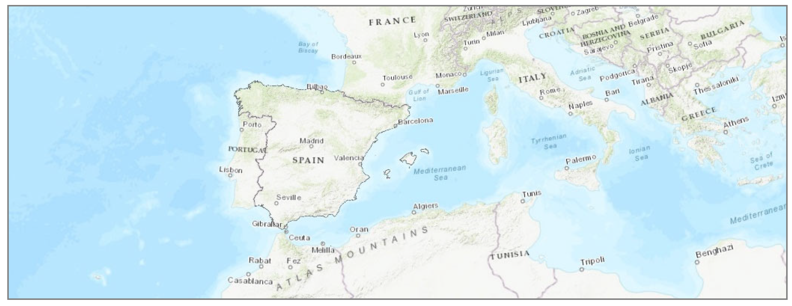
The study area covers the Spanish peninsula and the Balearic Islands between the longitudes of 9.34 west and 4.35 east, and between the latitudes of 35.98 and 44.80 north (
Figure 1). The Iberian Peninsula and the Balearic Islands are located in a temperate latitudinal zone, between the Atlantic Ocean and the Mediterranean Sea. This means that both types of climate, oceanic and Mediterranean, have a marked influence. Mainland Spain is a fairly mountainous continental mass, dominated by high plateaus and mountain ranges. In addition to the Pyrenees, the main mountain ranges are the Cantabrian Mountains, the Iberian System, the Central System, the Sierra Morena and the Betic System. The inland plateau (Meseta Central) is a vast plateau in the heart of peninsular Spain, divided in two by the Central System. The valleys of the main rivers, especially the Ebro in the northeast and the Guadalquivir in the southwest, together with the topography, determine the peninsular climate. Peninsular Spain is characterized by a wide range of climatic patterns due to its complex orography and its geographical location between the European subtropical and temperate zones. Spain’s geographical diversity makes it probably the country with the greatest climatic diversity in Europe. In general, it is characterized by a temperate climate, with hot summers and cold winters inland and milder summers and colder winters on the coast. Broadly speaking, Spain’s climate can be classified into five distinct zones: a hot-summer Mediterranean climate, a warm-summer Mediterranean climate, an oceanic climate, a semi-arid climate and a warm-summer continental climate.
2.3. Methodology
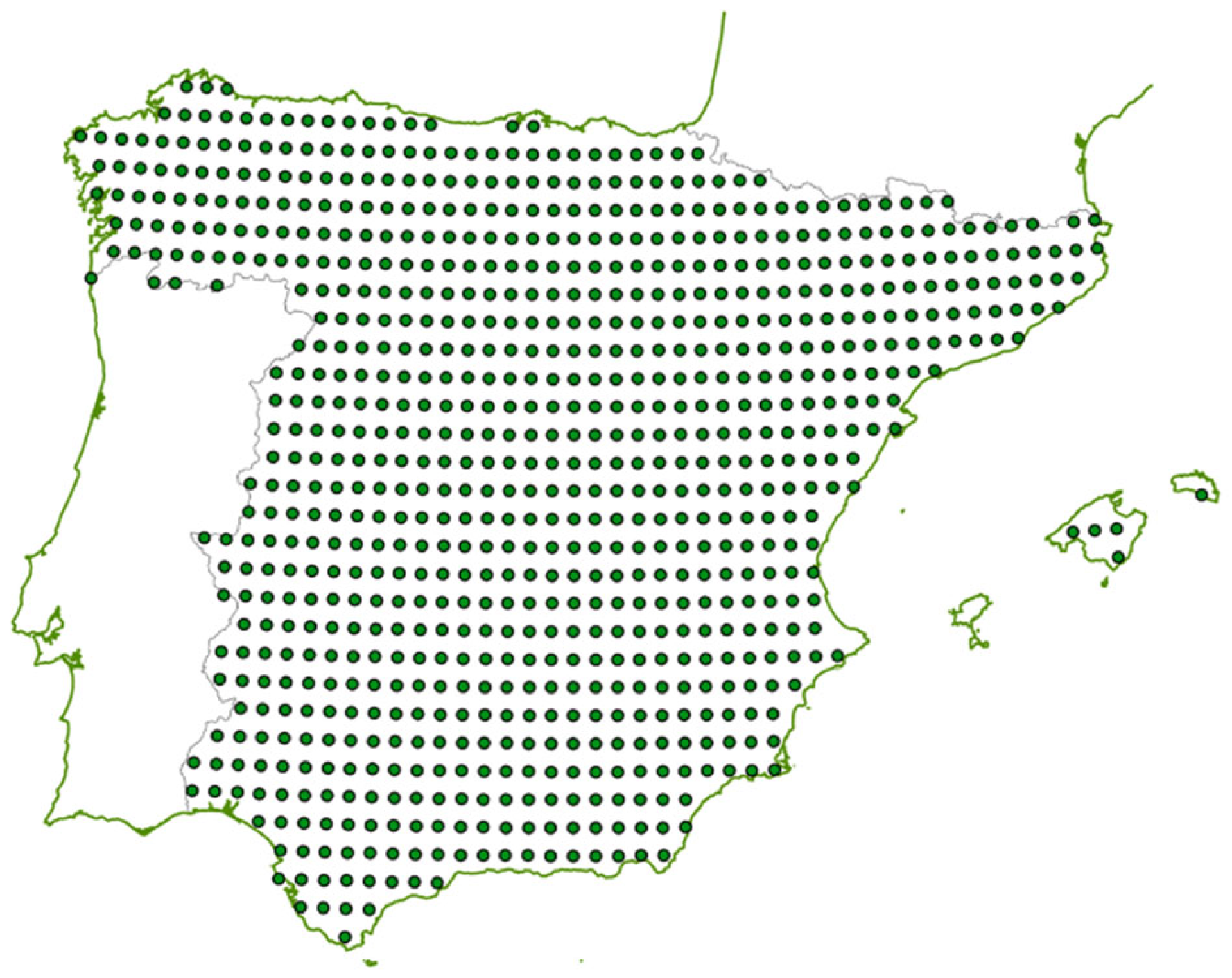
Since the main objective of the study was to analyze the climatic trends of mainland Spain and the Balearic Islands, the basic information that was used consists of daily data (between 1 January 1971 and 22 December 2022) provided by E-OBS relating to average (TG), maximum (TX) and minimum (TN) temperatures and precipitation (RR) for each of the 839 cells that make up the study territory (
Figure 2).
In line with this basic information, the following indicators were used in this research:
To assess the trend towards increasing extreme heat events, daytime and nighttime heatwaves (DHW & NHW) experienced between 1971 and 2022 were analyzed.
Regarding precipitation (RR), three annual drought indicators were used: the number of days without rain (RR = 0, or dry days, DD), the number of consecutive days with precipitation of less than 1 mm/day (CDRR1mm) and the sum of precipitation on days with less than 10 mm of rain (RR10mm). Three indices were used in the case of extreme precipitation: the highest 5-day precipitation amount (RRX5day), precipitation above the 99th percentile of wet days (total precipitation due to extremely wet days, RR30mm) and torrential precipitation (95th percentile of extremely wet days, RR60mm).
2.3.1. Heatwaves
There is no universal definition of a heatwave, but extreme events associated with particularly hot, sustained temperatures have been known to have a notable impact on human mortality, regional economies and ecosystems (EPA, 2014; Perkins & Alexander, 2013). As revealed by the high temperatures in Western Europe in 2003 (García Herrera et al., 2010) and the extreme heat events in Chicago in 1995 (National Weather Service, 1995), a heatwave (HW) is identified when a number of consecutive days reach temperatures over a certain hot threshold. Nevertheless, several hot threshold criteria exist to compute the consecutive days of a HW (Della-Marta et al., 2007; Fisher and Schär, 2010; Perkins & Alexander, 2013; Kostyrko et al., 2020; Roca et al., 2023; Serra et al., 2024).
In this paper, we use the concept of heatwave applied by the Spanish Meteorological Agency (AEMET). In this definition, a heatwave is considered an episode of at least three consecutive days in which the stations that are considered register maximums above the 95% percentile of the series of maximum daily temperatures for the months of July and August from the period 1971 to 2000 (AEMET, 2023). The reference period for determining heatwaves is therefore set between 1971 and 2000, to evaluate the warming process that has occurred since then. However, this definition has a major limitation: it refers only to maximum temperatures, not minimum ones. Maximum temperatures can have serious consequences, especially on heat stroke. However, the health effects are more pronounced in the case of night heat, when the inability to rest (especially in homes without air conditioning, as is generally the case in in Spain) can cause significant worsening of the respiratory and cardiovascular diseases that produce a high proportion of premature deaths (Royé, 2017; Arellano et al., 2022). For this reason, in this study we differentiate between heatwaves during the day (DHW) and at night (NHW). We use the concept of heatwave applied by the State Meteorology Agency (AEMET) but we differentiate between daytime heatwaves (DHW), if TX >= daytime heat threshold (DHT), and nighttime heatwaves (NHW), if TN >= nighttime heat threshold (NHT).
2.3.2. Precipitation: Extreme Events
The rainfall pattern in most of Spain is typically Mediterranean, with irregular rainfall amounts, sometimes due to heavy and intense torrential episodes in some months. In other months, rainfall is scarce. In addition, the varied topography of mainland Spain is related to significant rainfall differences between its areas. The variability in the precipitation regime has been widely studied (Martín-Vide et al., 2022, Lana et al., 2023). In this study, we will focus on the analysis of drought periods and extreme rainfall.
The manifestation of changes in the hydrological cycle for a high-warming storyline is not limited to precipitation but would substantially affect other variables such as soil moisture, runoff, atmospheric humidity and evapotranspiration. The changes are not limited to annual mean precipitation but may be stronger or weaker for individual seasons and for precipitation extremes and dry spells (IPCC, 2021).
Several methodologies have been developed and applied to study droughts (Serra et al., 2013; Raymond et al., 2016). The standard resolution of pluviometers (0.1 mm/day) usually distinguishes between wet or dry days. The environmental stress that accompanies a drought episode is caused by numerous consecutive days with a deficit of precipitation or with insufficient precipitation to compensate for the lack of humidity in the environment. It is therefore appropriate to analyze additional thresholds that characterize moderate rainfall, which may be related to phenomena such as the degradation of flora and soil, desertification due to erosion, low crop efficiency or the availability of water resources.
Three indices related to a dry spell (DS) regime have been analyzed to improve the knowledge of droughts in Spain. These are the number of days without rain (DD), the number of consecutive days with precipitation of less than 1 mm/day (CDRR1mm, associated with evapotranspiration processes) and the sum of precipitation on days with less than 10 mm of rain (RR10mm, saturation of thin surface layers).
The following indices were used for the case of extreme rainfall: a) the highest annual amount of rainfall accumulated in five consecutive days (RRX5days), b) extreme rainfall, understood as the sum of daily rainfall above the 99th percentile of wet days (RR > 1mm/day), and c) torrential rainfall (above the 95th percentile of extremely wet days). In the case study of mainland Spain and the Balearic Islands, the 99th percentile of rainy days (RR > 1 mm/day) for the period 1971–2022 is 30 mm/day, which is why we used the variable RR30mm (understood as the annual sum of daily rainfall equal to or greater than 30 mm), as an indicator of extreme rainfall (Fumière et al., 2020). In addition, due to the fact that hourly climate information was not available, the “torrential” rainfall indicator was established in this study as the annual sum of daily rainfall greater than the 95th percentile of days with extreme rainfall. This 95th percentile of extreme rainfall for the Iberian Peninsula corresponds to daily rainfall equal to or greater than 60 mm/day (RR60mm).
2.3.3. Trend Analysis
In the analysis of climate data, various regression methods have been employed to process datasets with diverse characteristics, particularly in the presence of outliers or non-linear trends. Ordinary least squares (OLS) regression is a commonly used parametric method for estimating linear relationships between variables. However, OLS is highly sensitive to outliers, which can result in biased estimates when it is applied to datasets with substantial variability or extreme values (Kutner et al., 2005). Given that climate data often exhibit such complexities, more robust methods are required to ensure reliable trend estimation.
To address these challenges, non-parametric methods like the Mann-Kendall test (MK) and Kendall-Theil-Sen (KTS) regression are frequently utilized. Unlike parametric approaches, the MK test and KTS regression do not assume any specific underlying distribution of the data:
MK is one of the most widely used non-parametric tests for detecting trends in climatic studies. Unlike parametric methods, it does not require the data to be normally distributed. It only requires independent data (Senent-Aparicio et al., 2023). The MK test has low sensitivity to abrupt peaks due to inhomogeneous time series.
The KTS regression estimates trend slopes based on the median of all possible pairwise slopes between data points. This makes KTS highly robust against outliers. It provides more reliable estimates for trends in climate datasets that may not adhere to normal distribution assumptions (Sen, 1968; Theil, 1992). The KTS method has been widely adopted in environmental and climate research due to its effectiveness in managing irregularities and extreme values in the data (Hirsch et al., 1982).
An alternative non-parametric method available in Python’s scikit-learn library is the TheilSenRegressor, which provides robust estimates by iteratively computing slopes to effectively manage outliers. However, due to its simpler and more straightforward calculation process, KTS is often preferred, especially when large datasets are processed, where computational efficiency and transparency are critical.
In this study, temporal trends were obtained (by OLS and KTS regression models) using as dependent variables the temperature indicators (TG, TX, TN, SU, TR, DHW and NHW) and precipitation (RR, DD, CDRR1mm, RR10mm, RRX5day, RR30mm and RR60mm), and the year as the independent variable. Since the central objective of this research was to evaluate the interactions between precipitation and temperatures (to validate the hypothesis +T → -RR), the total precipitation (RR) and the values of drought and extreme rainfall indicators were correlated (by OLS & KTS regression models) with the average (TG), maximum (TX) and minimum (TN) temperatures.
The Sen’s slope resulting from the KTS regressions, and the p-value of the MK test, allow an evaluation of the positive or negative trend, and the statistical significance of the developed models. In this study, following the criteria established by IPCC (2021):
If the MK test p-value < 0.01, it is considered “virtually certain” (99–100% statistical confidence).
If the p-value > 0.01 and <= 0.05, it is considered “extremely likely” (95–99%).
If the p-value > 0.05 and <= 0.1, it is considered “likely” (90–95%).
The term “more likely than not” has been used if the p-value is > 0.1 and <= 0.75 (75–90% confidence).
The Sen’s slope resulting from the KTS models was used to estimate the trend between 1971 and 2022, and the projections up to 2050.
The OLS and KTS models (1971–2022) were calculated for the whole of Spain and for each of the 839 E-OBS cells. For all of Spain, the OLS models were calculated including, together with the time variable (the year of observation), the most relevant geographical information (longitude, latitude, altitude and distance to the sea). These “geographical” models allowed a great improvement in the statistical significance of the OLS regressions.
2.4. Scenario 2050
One of the central objectives of this study was to make a prospective estimate of the climate in the relatively near future: the 2050 scenario. Prospective climate studies are carried out by the IPCC using various climate models, considering the radiative forcing produced by natural variables and by the human race. This paper used prospective trend models, established by assuming that the trends observed in the period 1971–2022 will continue to manifest themselves in the near future.
The IPCC assesses the impacts of climate change relative to baseline values of observed global temperature, which are typically averaged over 20 or 30 years. However, various authors have considered this “retrospective” procedure (based on the last 20 or 30 years) to estimate the real warming of the planet. Betts et al. (2023) discussed this metric, and proposed that the GW process should be quantified according to the criteria established in AR6, where future global warming levels (GWL) are defined using 20-year averages of projected temperature anomalies. The crossover time or “exceedance year” for a GWL is defined as the midpoint of the 20-year period (Gulev at al., 2021). Therefore, they propose an alternative indicator, the current global warming level (CGWL), calculated as a 20-year average centered at the end of the most recent calendar year for which complete observations are available across the year, using the average of the previous 10 years from observations, combined with the next 10 years from future projections or forecasts. This meets the requirement for rapid identification and consistency with established IPCC practice. Thus, we used the metric suggested by Betts et al. (2023), considering the 2050 horizon as the average of the projections made for the period 2041–2060.
The 2050 scenario (2041–2060) projects average, maximum and minimum temperatures, summer days, tropical nights, heatwaves (day and night), annual rainfall, drought and extreme precipitation indicators. In the case of rainfall, in addition to the estimates obtained from the time trend, future projections were established based on the KTS models of the various rainfall indicators and the temperature variables (TG, TX and TN). These future projections are significantly more robust than those based exclusively on time, according to the p-values resulting from the MK tests adjusted to the period 1971–2022. Thus, the procedure used consisted of first establishing the forecasts of the temperature variables in the horizon year (temporal trend) and then estimating future precipitation by means of the Sen’s slopes of the KTS models of precipitation and temperatures.
Finally, and with the aim of determining the most probable type of climate according to the Köppen classification in the horizon year, the average monthly temperatures and precipitations were estimated for each of the 839 cells that make up mainland Spain and the Balearic Islands. This allowed us to estimate the climate in 2050 for the case study, and to analyze the changes that will occur with respect to the reference period 1971–2000.
2.5. Methodological Framework
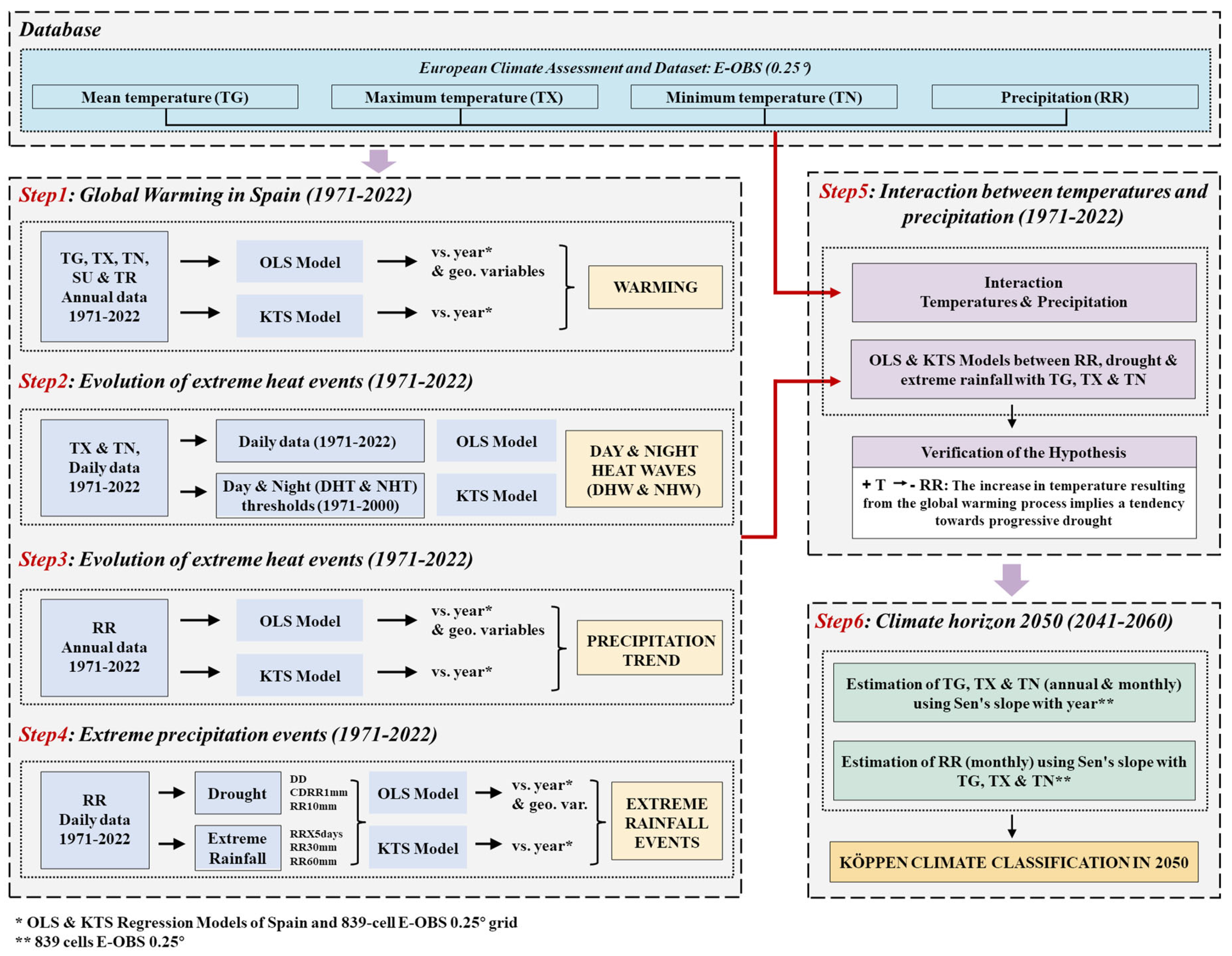
As illustrated in
Figure 3, this paper is divided into six successive steps. Step 1 (
Section 2.1) presents the most relevant information on the warming process in mainland Spain and the Balearic Islands. Next (step 2,
Section 3.2), extreme heat events are analyzed, heatwave thresholds (daytime and nighttime) are determined, and the evolution of these extreme events in the period 1971–2022 is examined. Steps 3 & 4 (
Section 3.3 and
Section 3.4) present the results of the study of the precipitation regime and the extreme rainfall events. Then, the interaction between the evolution of temperatures and precipitation is analyzed (step 5,
Section 3.5).
Finally, in
Section 4 (step 6 in the figure) of this article, on the discussion of the results, a prospective model is proposed to establish the most probable climate in the 2050 scenario.
3. Results
Based on the methodology in the preceding section, the main results of this study can be summarized as follows.
3.1. Global Warming in Spain (1971–2022)
The OLS models developed from the meteorological information provided by E-OBS (with temperatures as a dependent variable, and the year as an independent one) revealed a clear warming trend in the Iberian Peninsula (Spain) and Balearic Islands. Between 1971 and 2022, maximum temperatures increased on average 0.0512°C per year, showing a statistically significant trend (p value < 0.001). Minimum temperatures evolved in a similar way, increasing 0.0351°C per year and showing an equally significant trend (p-value < 0.001). According to the OLS model, mean temperatures (TG) increased 0.0422°C per year (p-value < 0.001).
Figure 4 shows the average annual evolution of TX and TN.
Table 1 shows the OLS models, with the mean annual point temperatures (TG, TX and TN) as independent variables and the UTM coordinates (X and Y), altitude, distance to the sea and year, as independent ones. As can be seen, the year and longitude always have a positive influence on temperatures, while the distance from the sea varies in sign (positive in TG and TX, negative in TN). Latitude and altitude have a negative effect. The signs of the variables are as expected, which highlights the aforementioned inversion of the effect of distance from the sea: spaces far from the coasts show a reduction in minimum temperatures.
Figure 5 shows the increase in mean, maximum and minimum temperatures between 1971 and 2022. The temperature variation was calculated using OLS models for each of the 839 analysis points, with TG, TX or TN as dependent variables, and the year as the only independent variable. All (839) TG and TX OLS models show that temperatures increased with the passage of time (1971–2022). In the case of TN, in 9 of the 839 models (not statistically significant at 95% confidence level), the temperatures had a negative effect, that is, they decreased over time. The rest of the OLS models of the TN show a positive effect.
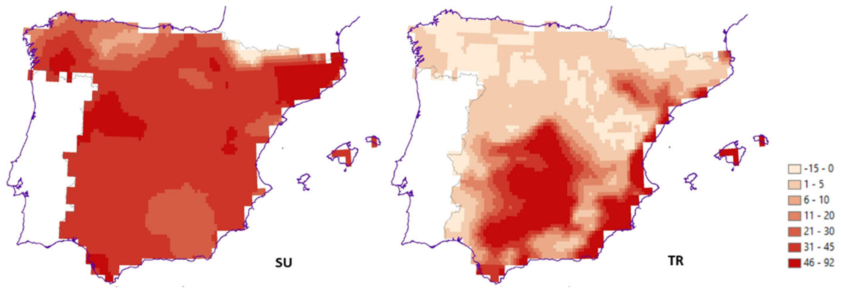
The evolution over time of the indicators SU (TX > 25°C) and TR (TN > 20°C) helps to better understand the warming process experienced in mainland Spain and the Balearic Islands.
Figure 6 shows the increase in SU (left) and TR (right) between 1971 and 2022.
The OLS model of summer days as a dependent variable and year as an independent variable shows that SU increased from 82.4 in 1971 to 117.9 in 2022. Between 1971 and 2022, summer increased on average across Spain by 36 days.
The OLS model of tropical nights and the year shows that the TR increased from 1.73 in 1971 to 14.12 in 2022. In contrast to the increase in SU, which was homogeneous throughout the Spanish territory, the increase in TR was concentrated in the Southern Plateau, the valleys of the Guadalquivir and Ebro rivers, and the Mediterranean coast, with increases of more than 30 nights between 1971 and 2022.
Therefore, the warming process resulting from climate change has been very pronounced in mainland Spain and the Balearic Islands, which represent a true hotspot of global warming. Spain has greatly exceeded the 2°C threshold compared to the pre-industrial era (Roca et al., 2023). Considering the difference between the temperatures that were really observed between 1971 and 2022, the increase in temperatures in mainland Spain and the Balearic Islands has been 3.27°C, which is well above the world average (1.19°C) and even above the average of the Mediterranean area (1.58°C), if the historical estimates of CMIP6 (
https://atlas.climate.copernicus.eu/atlas) are taken as a reference. Consequently, Spain is undoubtedly a hotspot in the GW process.
3.2. Evolution of Extreme Heat Events (1971–2022)
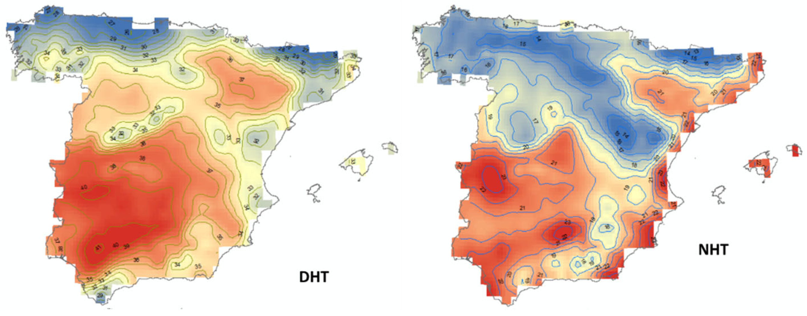
Following the AEMET methodology, daytime (AEMET, 2023) and nighttime (Arellano et al., 2022) heat thresholds were established for the reference period 1971–2000.
Figure 7 presents the results. The comparison between the two images allows us to understand the climatic differences of the daytime (DHT) and nighttime (NHT) heat extremes. The extreme daytime heat threshold (DHT) exceeds 35°C in the southern Plateau, and especially the valleys of the Guadalquivir River and the Ebro River. However, it rarely exceeds 32°C on the Mediterranean coast. In addition, the nighttime heat threshold (NHT) exceeds 20°C in much of the Mediterranean coast, in addition to the Community of Madrid (probably an effect of the urban heat island of the capital of Spain), and the valleys of the Guadalquivir and Ebro rivers.
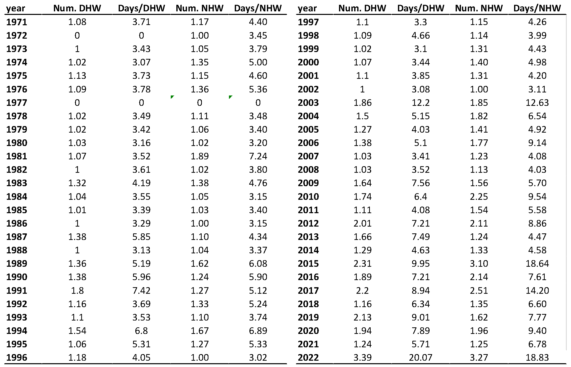
Table 2 shows the temporal evolution of daytime and nighttime heatwaves, and their duration. As shown, the number of DHW and NHW has been increasing decade by decade. If we compare the first 10 years (1971–1980) with the last 10 (2013–2022) of the series, the number of DHW and NHW rose from less than one per year to almost two. Heatwaves increased in number and length: the duration of heatwaves went up from 3 to 9 days on average.
Figure 8 illustrates the temporal evolution of the number of annual DHW and NHW, and their average duration. As shown, the increase in heatwaves and their duration is almost exponential.
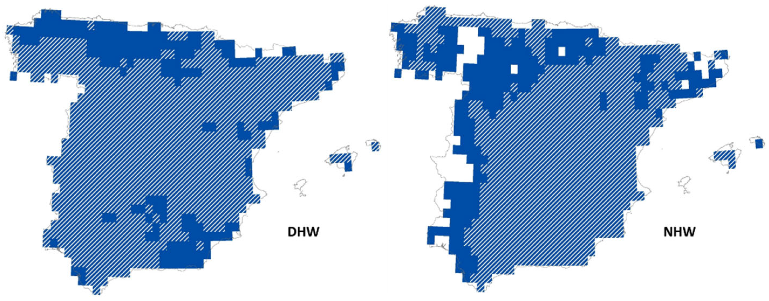
The trend of increasing extreme heat events in Spain could be evaluated by undertaking an OLS model for each of the 839 points for the period 1971–2022, with the number of heatwaves as the dependent variable and the year as the independent one.
Figure 9 shows (in blue) the peninsular and Balearic territory of Spain with a trend towards an increase in diurnal and nocturnal heatwaves. The white stripes show the area in which the regression coefficient is statistically representative at 95% confidence. As can be seen, almost the entire territory shows a statistically significant trend towards an increase in both DHW and NHW.
Therefore, it can be said that there is a clear trend towards an increase in extreme heat events in Spain. Both the number of days and nights that exceed heatwave thresholds, and the number and duration of DHW and NHW, have increased over the last 50 years, showing a significant trend from a statistical perspective. This confirms that Spain is a hotspot in the global warming process.
3.3. Evolution of Precipitation in Spain (1971–2022)
Average rainfall (RR) in Spain shows a trend towards greater drought, in accordance with the forecasts of climate models (IPCC, 2021). Between 1971 and 2022, there was a reduction in rainfall of 0.9310 mm/year (p-value = 0.250). For the entire period studied (1971–2022), there would have been a reduction of -48.41 mm, 8.9% of the average rainfall of the reference period 1971–2000. In the case of an annual sum of precipitation less than or equal to 10 mm/day (RR10mm), which is the saturation threshold of thin surface layers (Serra et al., 2014), the regression coefficient is -0.739 mm/year, with a statistical significance of p-value = 0.056.
Figure 10 shows that, despite the marked annual irregularity of rainfall, there is a tendency towards a reduction in annual rainfall and a parallel decrease in the sum of rainfall on days with rain <= 10 mm.
Table 3 shows the OLS models, with the sum of annual precipitation (RR) and the sum of annual precipitation <= 10 mm/day (RR10mm) as independent variables, and the geographic coordinates, altitude, distance from the sea and the year as independent variables. As can be seen, both models have a very similar structure, with the expected signs of the regression coefficients. Both RR and RR10mm increase with altitude and latitude, and decrease with longitude, distance from the sea and year. It is significant that when geographic variables are included, the regression coefficient of the year becomes statistically significant (p-value < 0.001). Notably, the better performance of the OLS model for the annual sum of precipitation < 10 mm/day. R
2 is equal to 0.643 in RR10mm, compared to 0.502 in the case of RR.
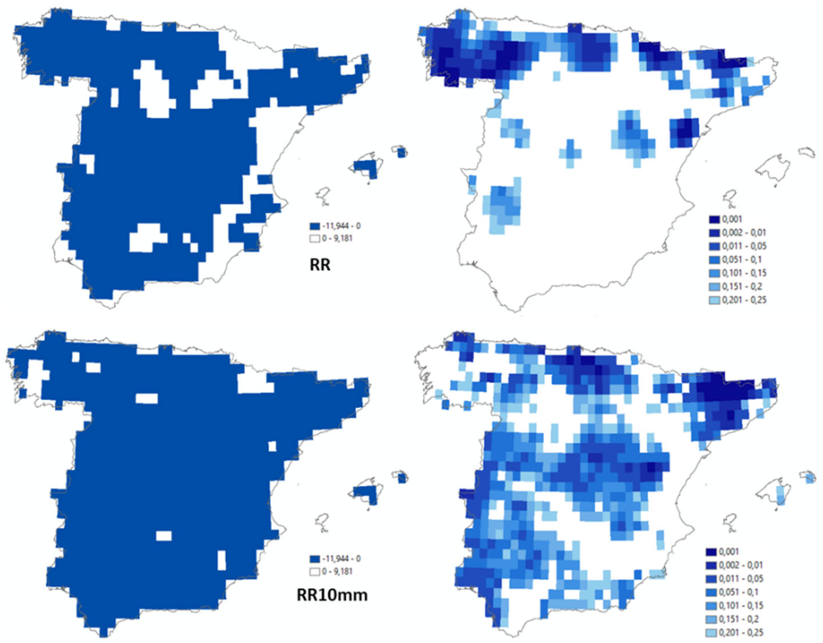
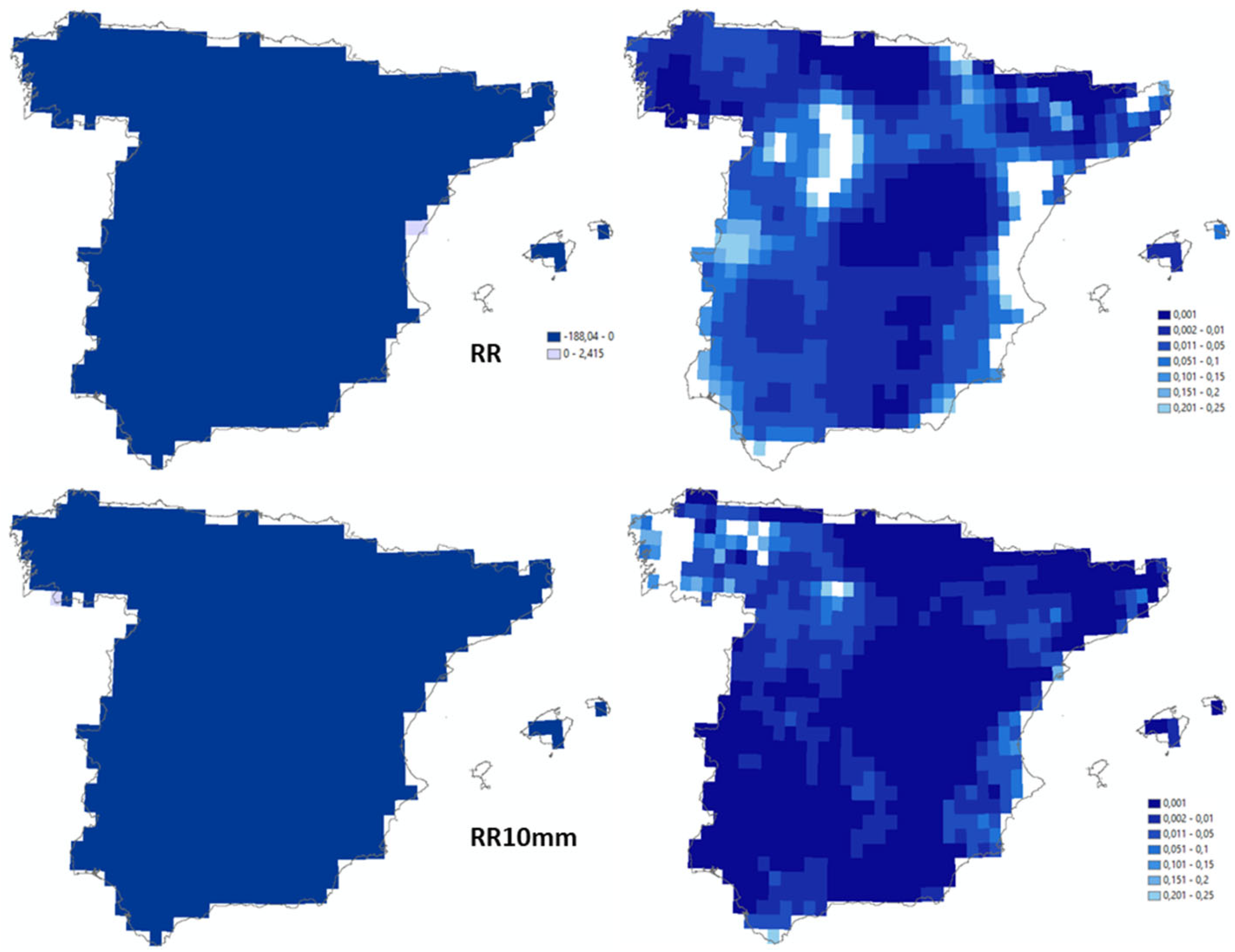
Figure 11 shows, for the 839 OLS models, the sign of the regression coefficients between RR and RR10mm as dependent variables, and the year as an independent variable. The image above left shows the territory in which the OLS models indicated a reduction in rainfall (blue color) between 1971 and 2022. The image above right shows the degree of statistical significance (p-value) of the models. In the bottom left is the Spanish territory (blue color) where the total annual rainfall below 10 mm/day has decreased. In the bottom right is the degree of statistical significance of the OLS models.
The almost general trend of greater drought is evident throughout Spain. However, OLS models, segmented by points, do not support reliable statistical evidence from a statistical point of view. In the case of total annual precipitation (RR), only 124 of the 839 models are significant at 95% confidence (152 models with a p-value <= 0.1). For annual rainfall below or equal to 10 mm/day, the significance of the models increases sharply. Although only 179 models are significant at 95% confidence (301 models with a p-value <= 0.1), a much higher proportion of the territory shows a tendency towards more significant drought. While the marked irregularity of annual rainfall (RR) does not allow for statistical certainty to confirm the temporal trend towards greater global drought, in the case of precipitation below or equal 10 mm/day (threshold of saturation of thin surface layers), the tendency towards drought is much more significant from a statistical point of view. In the Iberian Peninsula and the Balearic Islands, the process of climate change seems to represent greater variability of the precipitation regime, with increased periods of drought in parallel with the eventual increase in extreme rainfall events.
3.4. Extreme Precipitation Events (1971–2022)
As indicated above, IPCC climate models predict a trend increase in extreme events in the Mediterranean area precipitation regime. Drought periods are combined with extreme precipitation events. In this study, two annual drought indicators were used: the number of days without rain (RR = 0, or dry days, DD), and the number of consecutive days with precipitation of less than 1 mm/day (CDRR1mm). Three indices were used in the case of extreme precipitation: the highest 5-day precipitation amount (RRX5day), precipitation above the 99th percentile of wet days (precipitation total due to extremely wet days, RR30mm), and torrential precipitation (95th percentile of extremely wet days, RR60mm).
OLS models of dry days (DD) and consecutive days of precipitation of less than 1 mm/day (CDRR1mm) suggest a trend towards an increase in extreme drought events over time (
Figure 12). Contrary to the annual reduction in rainfall, DD & CDRR1mm have been increasing in Spain in the period 1971–2022. The OLS model (p-value = 0.322) suggests an increase of almost 1 dry day per decade, which would represent that during the entire period 1971–2022, the number of dry days per year would have increased by 5 days. Similarly, between 1971 and 2022 there was an increase of almost 4 days in the number of consecutive days with precipitation of less than 1 mm (p-value = 0.387). However, the marked irregularity in the rainfall pattern does not allow us to confirm the statistical significance of the increase in droughts in the study area.
Table 4 shows the geographic models of the temporal evolution of dry days and consecutive days with precipitation of less than 1 mm. As can be seen, both models show a similar structure. The only notable difference is that the longitude changes sign. Notably, when the geographic variables are considered, the year becomes representative at 99.9% confidence (p-value < 0.001), which confirms the trend towards an increase in drought events in Spain.
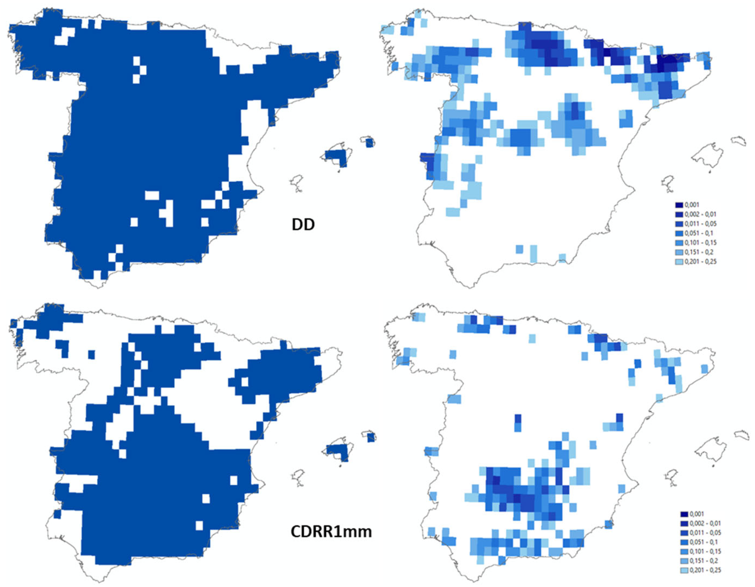
Figure 13 presents the geographical distribution of the territory with an increase in DD and CDRR1mm (in blue, left) and the statistical significance of the OLS models (right). As can be seen, the increase in dry days was almost generalized in the period 1971–2022. In practically all of mainland Spain and the Balearic Islands (in 90.2% of the territory), DDs have increased. However, it is striking that this trend towards an increase in DD did not occur on the Valencian coast (located in the east of the peninsula), when this is an area that is potentially exposed to greater desertification. Regarding CDRR1mm, although there was growth in most areas (63.2% of the territory), the trend towards an increase in consecutive days of rain of less than 1 mm is less pronounced.
In any case, the statistical significance of the models is relatively low. In only 12.4% of the territory, the increase in DD is significant at 90% confidence. The proportion is even lower in CDRR1mm, where in only 7.9% of the peninsular and Balearic territory the trend towards an increase in consecutive days without precipitation is significant (p-value < 0.1).
It can therefore be concluded that although the trend towards an increase in drought periods is growing in Spain, the OLS models developed at a local scale (839 points) allow us to affirm a medium-low level of confidence in extreme meteorological drought events. In
Section 3.5, on the analysis of composite events resulting from the interaction between temperatures and precipitation, the joint effects of both variables are presented and the trend towards greater hydrological-ecological drought is evaluated.
OLS models of extreme precipitation indicators (the highest 5-day precipitation amount, precipitation above the 99
th percentile of wet days and torrential precipitation) show an increase in this type of extreme weather events in the period under study. For the highest accumulated precipitation in 5-day periods (RRX5days), the OLS model results have a confidence level of about as likely as not 33–66% (p-value = 0.591). Nevertheless, they show an increase of 1.95 days for the period 1971–2022. Unlike RRX5days, rainfall above 30 mm/day (precipitation above the 99
th percentile of wet days) increased significantly between 1971 and 2022. The annual increase of RR30mm was 0.2282 mm, which represents a very high level of confidence (p-value = 0.043). The increase in torrential rainfall (RR60mm in this study) in the period 1971–2022 can be considered a virtually certain fact (p-value = 0.002). The OLS model shows that RR60mm increased by 0.0827 mm/year in the period studied, which represents an increase in torrential rainfall of 360%.
Figure 14 shows the temporal evolution of the extreme precipitation indicators used.
Table 5 shows the geographic models of the temporal evolution of the highest 5-day precipitation amount, precipitation above the 99th percentile of wet days and torrential precipitation. RRX5days and RR30mm show a similar structure, with a negative coefficient for distance to the sea, longitude and altitude. Only latitude and year have a positive impact. However, in the case of RR60mm, longitude becomes positive: being closer to the Mediterranean Sea represents an increase in torrential rainfall. All variables are significant at 99.9% confidence, which confirms the hypothesis of a general trend towards greater extreme rainfall.
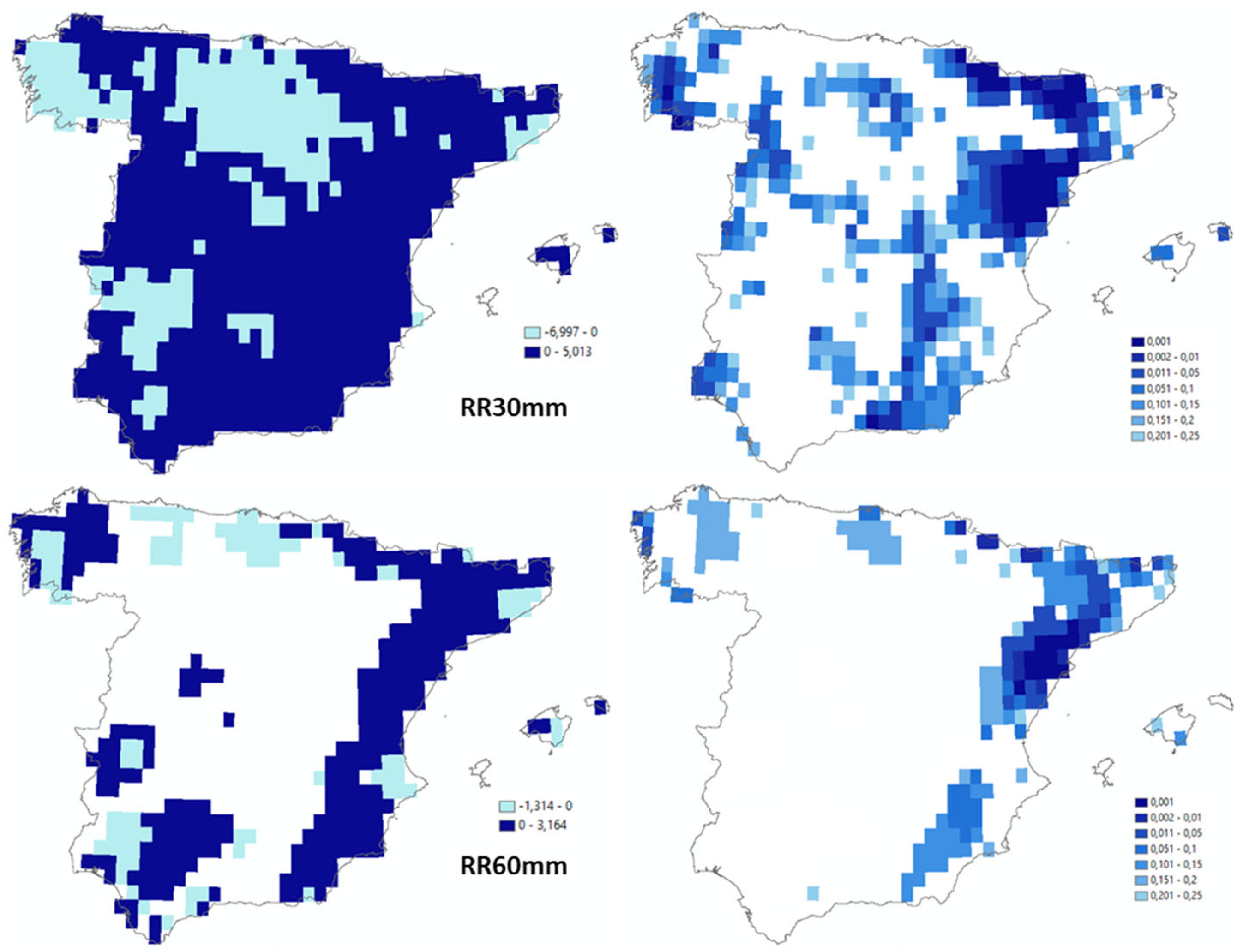
Figure 15 shows the territorial distribution of extreme and torrential rainfall in mainland Spain and the Balearic Islands resulting from the OLS models. The top of the figure shows RR30mm and the bottom RR60mm. On the left is the trend towards increasing (in dark blue) or decreasing (in light blue) extreme rainfall, and on the right is the statistical significance of the OLS models.
As can be seen, the increase in extreme rainfall (RR30mm) is relatively widespread, but not unvarying (light blue is the area where RR30mm decreases). In Andalusia, Castilla La Mancha, the Communities of Murcia and Valencia, southern Catalonia, the Balearic Islands, Aragon, Navarre, the Basque Country and Asturias, torrential rainfall increased between 1971 and 2022. However, in Extremadura, Cantabria, part of Castilla-León, part of Catalonia (including the Barcelona metropolitan area) and Galicia, there has been a decrease in episodes of very intense rainfall.
In the lower left image, the dark blue or light blue color indicates the areas where torrential rainfall (>= 60 mm/day) occurred in the period 1971–2022. As can be seen, the distribution of torrential rainfall is concentrated in only a limited part of Spain, showing a clear tendency towards an increase on the Mediterranean coast (high confidence level), inland Galicia (medium confidence level) and the Guadalquivir valley (low confidence level).
In summary, there is a majority trend towards an increase in extreme rainfall in mainland Spain and the Balearic Islands. It can also be said with a high level of confidence that the rainfall regime is evolving towards greater extremes. Periods of drought are increasing (high level of confidence) as are extreme rainfall events (very high level of confidence).
3.5. Interaction between Temperatures and Precipitation (1971–2022)
As indicated in the introduction to this article, a large body of literature analyzes the interaction between the evolution of temperatures and precipitation, especially in relation to extreme events. The association between extreme weather events in terms of temperature and precipitation is one of the most notable features of climate change (IPCC, 2021). In the Mediterranean area, this association occurs mainly between the warming process and the tendency towards reduced rainfall (Rodrigo, 2019). The attached tables show this association by means of Pearson correlation coefficients.
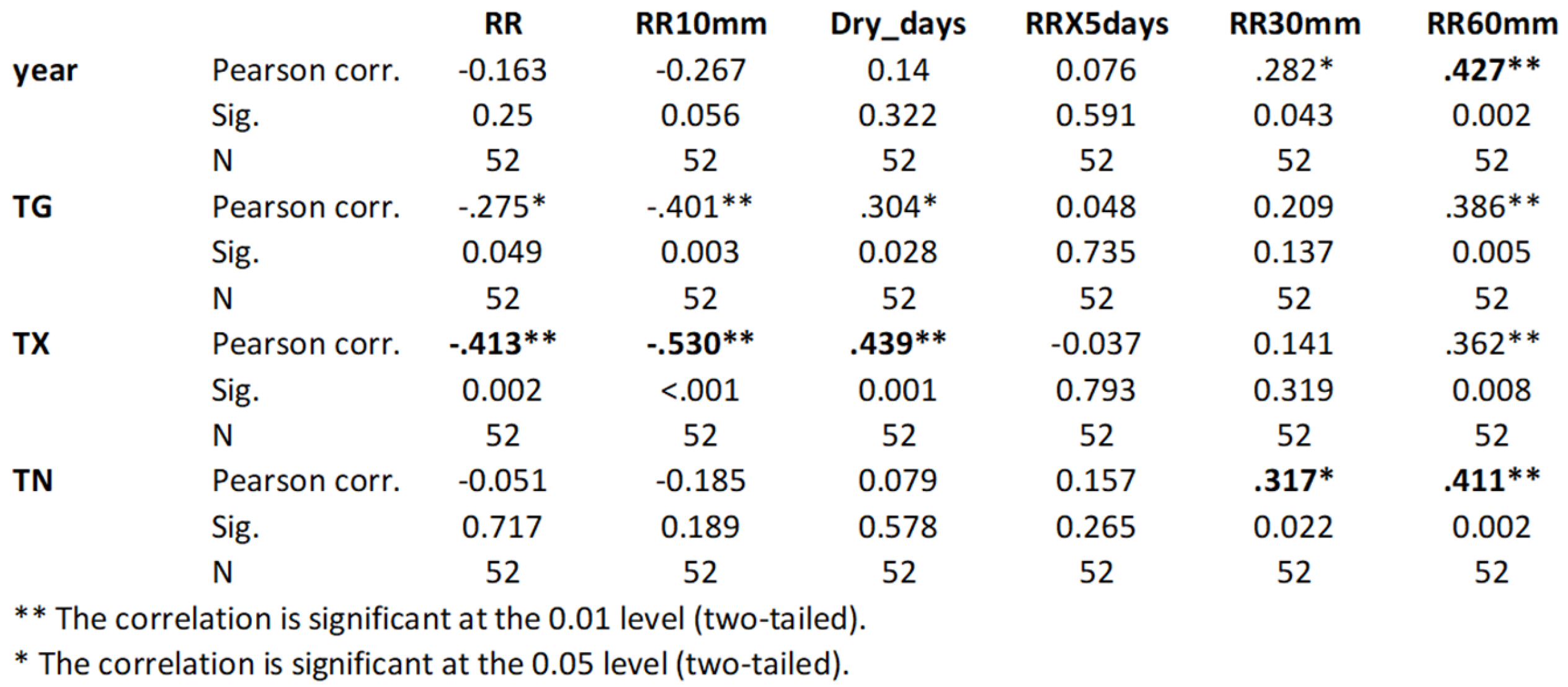
Table 6 shows the annual averages for all of Spain and
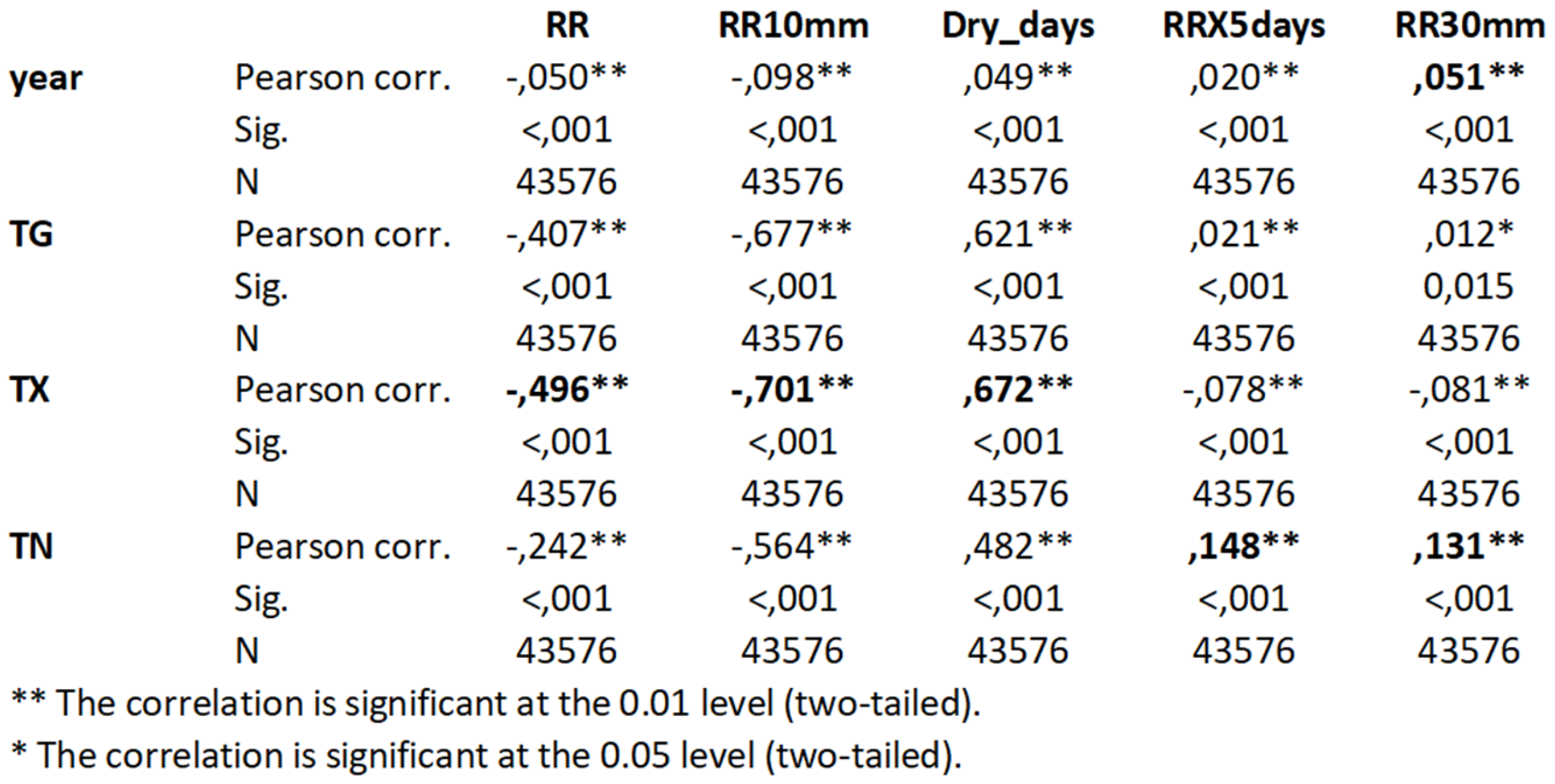
Table 7 shows the annual averages for the 839 points in the territory.
As can be seen, the maximum temperature (TX) is the temperature indicator that shows the highest correlation, both in the case of the average for Spain and for all the 0.25° cells of E-OBS, with the total precipitation (RR), and the drought indicators (RR10mm and DD). This is a much higher correlation than the simple passage of time (year). The increase in temperatures, especially maximum temperatures, is associated with a decrease in rainfall.
In the case of extreme precipitation, the most pronounced correlation occurs with the minimum temperature (TN). The warmest years at night are those that show a greater tendency towards extreme precipitation (RRX5days, RR30mm and RR60mm). However, the improved performance of the OLS model for extreme precipitation with (minimum) temperatures does not show very substantial improvements compared to the year. This is in contrast to the situation with total precipitation and drought indicators. In particular, torrential rains are more closely correlated with the passage of time than with temperatures.
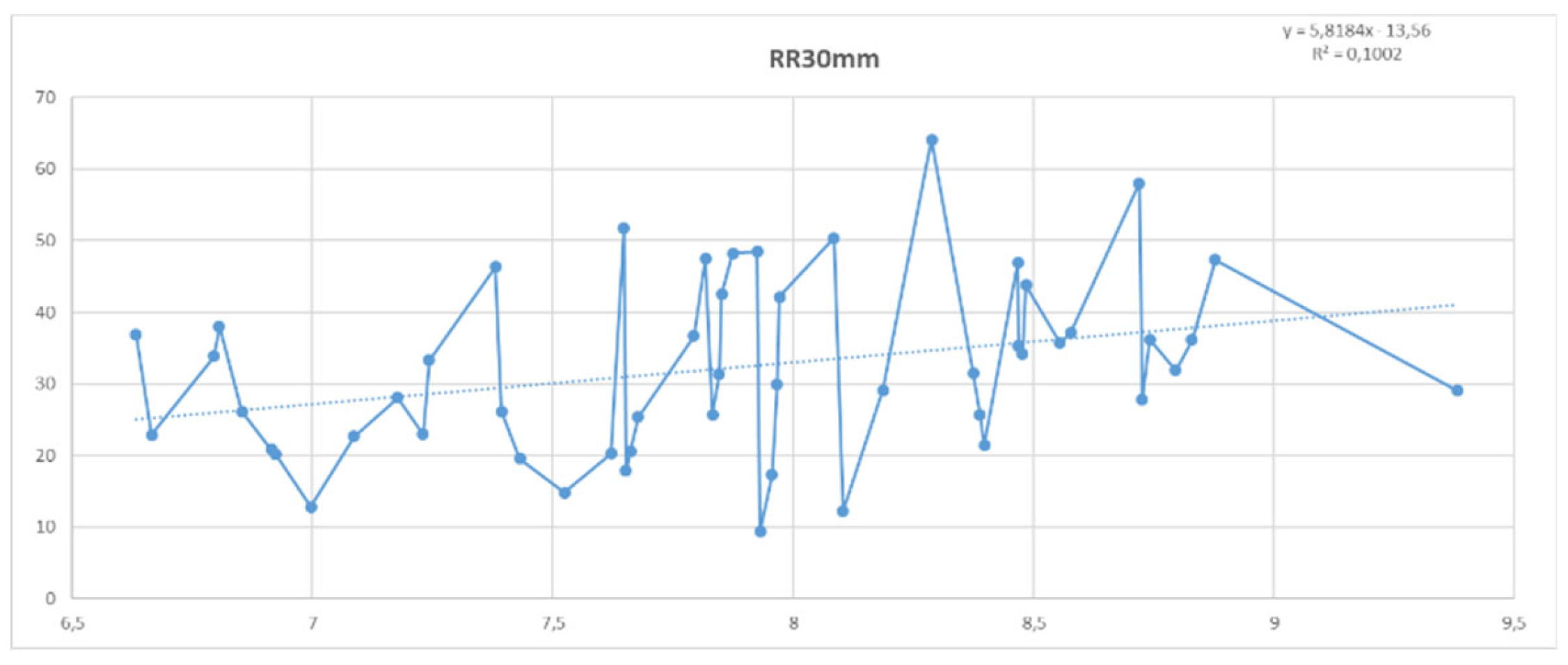
Figure 16 shows the OLS models of RR and RR10mm as dependent variables and TX as the independent variable. The OLS models of the total annual rainfall and the rainfall <= 10 mm with the annual average of maximum temperatures confirm the strong link between the increasing evolution of temperatures and the decrease in rainfall in mainland Spain and the Balearic Islands. An increase of 1°C in TX represents a reduction in annual rainfall of 38,413 mm/year and 23,827 mm/year, in the case of rainfall less than or equal to 10 mm/day. Unlike the case in which the independent variable was the year, both models are statistically significant at 99% confidence. Therefore, it can be stated with a high level of confidence that the rainfall regime is evolving towards greater drought if the warming of the climate in Spain is considered. The hypothesis +TX => -RR is confirmed.
Figure 17 shows the geographic distribution of OLS models of precipitation and maximum temperature in the period 1971–2022. The top left (in dark blue, models with a negative regression coefficient) shows annual precipitation. The bottom left shows annual precipitation >= 10 mm. On the right is the statistical significance of the RR and RR10mm models.
As can be seen, the regression coefficient of the 839 OLS models of the TX variable denotes the complete generalization of the inverse relationship between maximum temperatures and the sum of annual precipitation (total and greater than or equal to 10 mm/day). The statistical significance of the OLS models is very high in practically the entire peninsular and Balearic territory. This confirms the very high level of confidence in the negative impact of temperatures (especially maximum temperatures) and rainfall.
Figure 18 (average for all of Spain) and
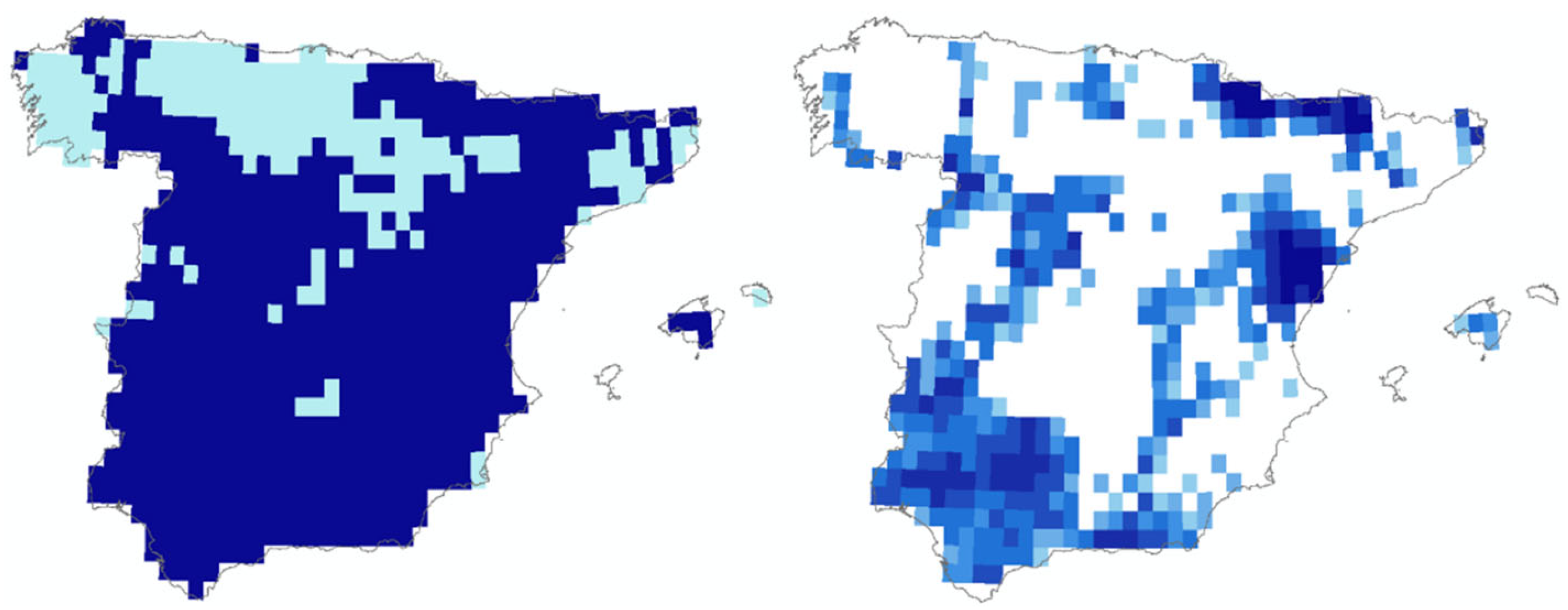
Figure 19 (for the 839 0.25° cells of E-OBS) show the OLS models of the evolution of annual extreme rainfall (RR30mm) and minimum temperatures (TN). The OLS RR30mm model shows a clear positive correlation with TN. As minimum temperatures rise, extreme precipitation increases (at a rate of 5.8184 mm/°C). The model is significant at 95% confidence (p-value = 0.022), which confirms with a high level of confidence the hypothesis that the warming process that Spain is experiencing is associated with an increase in extreme precipitation.
The geographical distribution of the results of the OLS models by the E-OBS analysis points (
Figure 19) confirms that in most of peninsular and insular Spain the aforementioned process of positive association between extreme precipitation and the increase in temperatures resulting from climate change is taking place (the dark blue color of the left image represents a positive sign of the OLS models). However, this trend is not completely uniform, with the latitudes located further north showing a negative sign (light blue color in the left image). The right image shows the statistical significance of the models.
The warming process affecting the Iberian Peninsula and the Balearic Islands is significantly affecting the rainfall regime. There is a clear interaction between temperatures (especially maximum, but also minimum) and rainfall. However, this interaction occurs in the opposite way, depending on the thresholds that mark the drought processes (<= 10 mm/day) of extreme rainfall (>= 30 mm/day). While increasing temperatures (especially maximum) significantly reduce the rainfall that marks the drought threshold, this increase in temperatures (especially minimum) determines an increase in extreme rainfall. The joint result of both opposing processes (RR) is the predominance of the tendency towards drought, which determines a progressive aridification of the Iberian climate. It can therefore be concluded with a high level of confidence that climate change is leading to a clear tendency towards a reduction in rainfall.
4. Discussion
The previous section summarizes some of the main climatic changes that have occurred since 1971 in mainland Spain and the Balearic Islands. According to data provided by the Copernicus Interactive Climate Atlas (
https://atlas.climate.copernicus.eu/atlas), the warming process in Spain between 1971 and 2022, determined from the OLS models of the annual median temperature of the 30 CMIP6 climate models (dependent variable) and the year (independent variable), was significantly higher (1.87°C) than that experienced on a global scale (1.27°C), and even slightly higher than that of the Mediterranean area (1.83°C).
E-OBS data show even more pronounced warming than that indicated by CMIP6 models. The information provided by E-OBS (0.25°) indicates that the Iberian Peninsula is one of the global hotspots of the global warming process. Between 1971 and 2022, average temperatures (TG) have increased by 2.17°C (KTS regression). This increase is especially significant in the maximums (2.62°C) compared to the minimums, which have less pronounced increases (1.81°C). The warming process is widespread, and is statistically significant at 99% confidence in the entire peninsular and insular territory, according to the Mann-Kendall (MK) test: p-value of 3.21447E-11 (TG), 4.42654E-11 (TX) and 4.32449E-10 (TN). The development of the OLS models of temperatures and the year for the 839 cells of E-OBS 0.25° confirms the statistical validity of the models for practically all of mainland Spain and the Balearic Islands. It can therefore be concluded that the warming process experienced in Spain has a very high confidence level.
The warming resulting from climate change in Spain is accompanied by a marked increase in summer days (SU) and tropical nights (TR). Between 1971 and 2022, summer increased by 34.2 days (KTS regression). Tropical nights increased by 12.1 days. The MK test confirms the very high confidence of the models: p-value = 1.652E-09 (SU) and 1.3332E-10 (TR).
Table 8 compares the results of the OLS and KTS regressions for the temperature indicators that were used. As can be seen, all KTS models (and OLS models) are highly significant, which confirms the very high confidence of global warming in mainland Spain and the Balearic Islands in the period 1971–2022.
Taking as a reference the threshold of differentiation between the cold season (“winter”) and the warm season (“summer”) at 15°C of average daily temperature (Zheg et al., 2023), the “summer” increased (OLS) from 132 days in 1971 to 169 days in 2022. The warm season, that is, the period of time when cooling needs increase and heating needs decrease, increased by over a month between 1971 and 2022. The warming process in Spain is an unequivocal truth.
However, in the case of precipitation, the trend towards a drier climate cannot be asserted with the same statistical accuracy. The irregularity of precipitation does not allow us to affirm the statistical reliability of the reduction in precipitation in Spain. The MK test does not allow a 95% confidence level (p-value = 0.324) of a tendency towards drought.
Table 9 compares the results of the OLS and KTS regression models for total annual rainfall, and the sum of annual rainfall less than or equal to 10 mm/day (“drought”) and equal to or greater than 30 mm/day (extreme rainfall). As can be seen, the MK test indicates that the trend towards drought (RR <= 10 mm) is highly significant (p-value =0.057), but this trend is partially offset by the increase in extreme rainfall (RR >= 30 mm), which is also highly significant from a statistical point of view (p-value = 0.038). The composition of the trend towards drought and towards an increase in extreme precipitation explains the medium significance of the evolution of total precipitation, which tends to decrease with a “probable” confidence level, according to IPCC criteria.
In fact, the trend towards increasing drought occurs mainly in the segment of daily precipitation between 5 and 10 mm (p-value = 5.79000E-003), since <= 1 mm/day increases significantly (p-value = 2.37858E-007), which results from the very sharp increase in “dry” days.
As indicated in
Section 3.4, there is a clear interaction between temperatures (especially maximum, but also minimum) and precipitation.
Table 10 presents the results of the OLS and KTS regressions of the precipitation indicators and temperatures: TX in the case of RR and RR10mm, and TN in the case of RR30mm.
When maximum temperatures are considered, the KTS regression confirms with a very high level of confidence (p-value = 0.00747) the hypothesis +TX → - RR. A 1°C increase in maximum temperature leads to a reduction in precipitation of 34.23 mm/year. The trend towards drought (RR10mm) is especially evident with increasing maximum temperatures (p-value = 0.00037). In addition, the KTS model of an increase in extreme rainfall, shows a clear interaction with the evolution of minimum temperatures (p-value = 0.02451) but does not show significant improvements with respect to the previous year.
The KTS models allow a relatively robust estimation of the climate of mainland Spain and the Balearic Islands in a relatively closed scenario (2050). Considering this scenario, TG would most likely reach 15.84°C in 2050, 1.43°C higher than the average temperatures of the last 10 years. An equally significant increase was found in TX (1.77°C) and TN (1.20°C).
Table 11 shows the average temperature indicators (TG, TX, TN, SU and TR) observed in the periods 1971–2000 and 2013–2022, and those estimated for 2050 by KTS regressions. Summer days (SU) would be extended by 22.7 and tropical nights (TR) by 7.2 nights on average throughout Spain, compared to the period 2013–2022.
The KTS models can also be used to estimate the evolution of total rainfall, rainfall less than or equal to 10 mm/day, and extreme rainfall (>= mm/day) in the 2050 scenario.
Table 12 shows the 2050 estimate of RR, RR10mm and RR30mm, and the changes experienced with respect to the reference period (1971–2000) and the last 10 years (2013–2022). As indicated above, the estimates for 2050 can be considered robust, given the very high statistical significance of the models obtained. As described in the methodology section, KTS models were applied to the forecasts of variation up to 2050 in the maximum temperatures (RR and RR10mm) and minimum temperatures (RR30mm).
If the trend experienced in the last 52 years continues, the average annual rainfall in mainland Spain and the Balearic Islands in the horizon year, 2050, will be well below 500 mm/year (417 mm). This is 126.3 mm less than in the period 1971–2000 and almost 109.6 mm less than in the last 10 years. Spain’s climate will accelerate its trend towards drought, as evidenced by the estimated accumulated rainfall of less than or equal to 10 mm/day (threshold of saturation of thin surface layers). The RR10mm will most likely be around 214 mm in 2050, which is almost 80 mm less than in the period 1971–2000 and nearly 60 mm less than in the last 10 years. The periods of drought will be longer, reducing the rainfall regime that allows the aquifer to be recharged, which is why meteorological drought will be increased by environmental drought. In contrast, extreme rainfall will increase (with a high level of confidence) in the horizon year (2050), to reach around 43 mm accumulated throughout the year. This is an increase of almost 45% compared to 1971–2000 and 6% compared to 2013–2022.
Taking as a reference the 20-year moving averages (retrospective and prospective) for 2050 (period 2041–2060), the average climate of peninsular and insular Spain (Balearic Islands) will experience a fundamental change compared to the reference period 1971–2000. If we consider the dominant climate in the entire territory,
Table 13 presents the most relevant information to determine the type of climate (Köppen) in Spain in 1971–2000 and 2041–2060.
In the reference period 1971–2020, the average climate of Spain could be classified as Csa (hot-summer Mediterranean climate, with the coldest month averaging above −3°C, at least one month’s average temperature above 22 °C and at least four months averaging above 10°C, with an annual precipitation level greater than the dryness threshold). The dryness threshold (Dt) is 20*TG+140 if the sum of summer rainfall (RRs) is between 1/3 and 2/3 of the sum of annual rainfall. By 2050 (moving average 2041–2060), the KTS model (with maximum temperature as the independent variable) predicts a marked change in the Köppen climate classification. The climate of mainland Spain and the Balearic Islands would change from Csa (hot-summer Mediterranean climate) to BSk (cold semi-arid climate), with average annual temperatures below 18°C and rainfall below the dryness threshold.
The model predicts a significant reduction in rainfall, with a tendency for rainfall to decrease below the drought level (RR <= 10 mm), which would significantly offset the trend towards an increase in extreme rainfall (RR >= 30mm). At the same time, the increase in average temperatures would determine the widening of the drought threshold, which would probably be above the total annual rainfall.
The geographic distribution of climate change is clearly observed through detailed modelling for the 839 study points. For the 0.25° spatial resolution cells, the Köppen climate classification has been modelled. The reference period 1971–2000 is compared with the most probable scenario for 2050 (period 2041–2060).
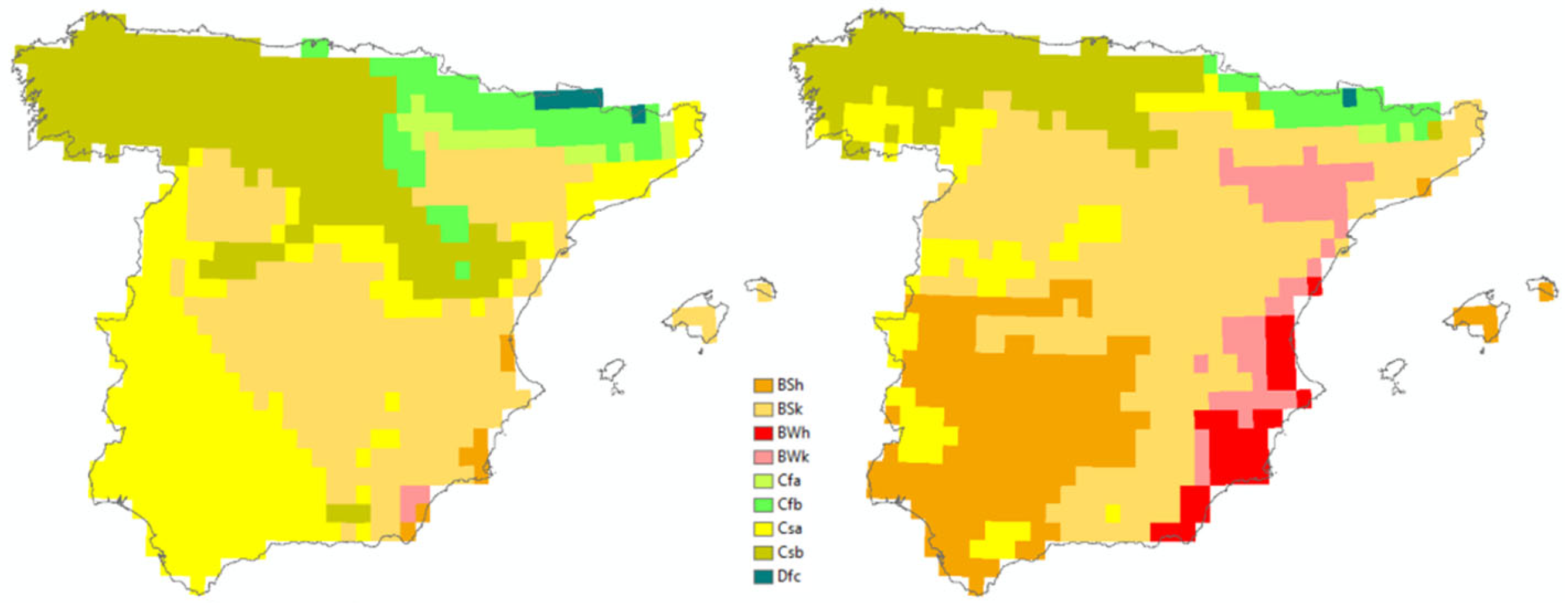
Figure 20 allows us to compare the spatial distribution of the climate that Spain will probably experience between 1991–2020 (left) and 2041–2060 (right).
The complexity of the climate in Spain is evident not only in the variety of climates existing in the peninsula and the Balearic Islands, but also in their evolution over time. The comparison between the two images confirms the marked change in climate expected in the coming decades. One of the most notable characteristics of the probable climate change is the drastic reduction of the typical Mediterranean climate (Csa, in yellow). In the near future, the dominant climate in peninsular and insular Spain (Balearic Islands) will evolve towards a steppe-type climate, with the expansion of “brown” Spain (Font, 83). The climate transfer matrix between 1971–2000 and 2041–2060 (
Table 14) shows this trend.
The climate is expected to be increasingly dry and warm. Over 40% of the territory has gone from a C (temperate) to a B (dry) climate, which confirms the trend towards a progressive decrease in rainfall. As indicated, the drastic reduction of the typical Mediterranean climate (Csa) is particularly notable. This would go from representing 24.43% of the peninsular and island territory in the reference period 1971–2000 to 10.13% in the period 2040–2060. The Csa climate will vary mainly towards a drier and warmer climate (53.17% towards BSh and 31.71% towards BSk). At the same time, the reduction in Csb (Mediterranean with “cool” summers) climate is very relevant. It will shift from 27.06% of the territory in the period 1971–2000, to only 14.78% in the near future climate. There will be a change in the mild Mediterranean climate zones (Csb) towards a cold semi-arid climate (BSk, 49.78%) and towards a temperate-hot summer climate (Csa, 18.94%).
The “cold” steppe climate (BSk) will represent the dominant climate in mainland Spain by 2050 (39.81%), progressively displacing the typical Mediterranean climate. However, there is a clear trend towards these steppe areas evolving towards a hotter climate (BSh, 24.81% of the BSk of the reference period), or even drier (BWk, 20.16%) and hotter (BWh, 12.79%). “Desert” climates (BW) will increase significantly, from representing less than 1% of the territory in the period 1971–2000 to over 10% in the near future. These climates, where annual rainfall is less than 5 times the dryness threshold, will be located mainly on the Mediterranean coast and in the Ebro River valley.
If the trends of the 1971–2022 period continue, prospective methods suggest that by the middle of this century the climate will be noticeably drier and warmer, with steppe and even desert Spain dominating. These conclusions differ from other prospective studies (Beck et al., 2018), which suggest a less extreme evolution with the traditional Mediterranean climate still predominating.
Figure 2.
0.25° cells derived from E-OBS.
Figure 2.
0.25° cells derived from E-OBS.
Figure 3.
Methodological framework.
Figure 3.
Methodological framework.
Figure 4.
Warming in Spain (1971–2022).
Figure 4.
Warming in Spain (1971–2022).
Figure 5.
Increase in TG, TX and TN (1971–2022).
Figure 5.
Increase in TG, TX and TN (1971–2022).
Figure 6.
Increase in summer days and tropical nights between 1971 and 2022.
Figure 6.
Increase in summer days and tropical nights between 1971 and 2022.
Figure 7.
Heat thresholds (1971–2022).
Figure 7.
Heat thresholds (1971–2022).
Figure 8.
Number of daytime and nighttime heatwaves and days of duration. 1971–2022.
Figure 8.
Number of daytime and nighttime heatwaves and days of duration. 1971–2022.
Figure 9.
Increasing trend of HW. 1971–2022.
Figure 9.
Increasing trend of HW. 1971–2022.
Figure 10.
Annual rainfall and annual precipitation <= 10 mm/day (1971–2022).
Figure 10.
Annual rainfall and annual precipitation <= 10 mm/day (1971–2022).
Figure 11.
Temporal trend (1971–2022) of annual rainfall and < 10 mm/day.
Figure 11.
Temporal trend (1971–2022) of annual rainfall and < 10 mm/day.
Figure 12.
Dry days and consecutive days with precipitation of less than 1 mm/day (1971–2022).
Figure 12.
Dry days and consecutive days with precipitation of less than 1 mm/day (1971–2022).
Figure 13.
Temporal trend (1971–2022) of dry days and consecutive days with a precipitation of < 1mm.
Figure 13.
Temporal trend (1971–2022) of dry days and consecutive days with a precipitation of < 1mm.
Figure 14.
Five-day precipitation amount, extreme wet days and torrential precipitation (1971–2022).
Figure 14.
Five-day precipitation amount, extreme wet days and torrential precipitation (1971–2022).
Figure 15.
Extreme and torrential precipitation (1971–2022).
Figure 15.
Extreme and torrential precipitation (1971–2022).
Figure 16.
Annual rainfall and annual precipitation <= 10 mm/day vs. TX.
Figure 16.
Annual rainfall and annual precipitation <= 10 mm/day vs. TX.
Figure 17.
Annual rainfall and annual precipitation <= 10 mm/day vs. TX (839 models).
Figure 17.
Annual rainfall and annual precipitation <= 10 mm/day vs. TX (839 models).
Figure 18.
Annual precipitation >= 30 mm/day vs. TN.
Figure 18.
Annual precipitation >= 30 mm/day vs. TN.
Figure 19.
Annual precipitation >= 30 mm/day vs. TN (839 models).
Figure 19.
Annual precipitation >= 30 mm/day vs. TN (839 models).
Figure 20.
Köppen climate classification. 1991–2020 vs. 2041–2060.
Figure 20.
Köppen climate classification. 1991–2020 vs. 2041–2060.
Table 1.
OLS models (TG, TX and TN).
Table 1.
OLS models (TG, TX and TN).
Table 2.
Extreme hot days and nights and daytime and nighttime heatwaves (1971–2022).
Table 2.
Extreme hot days and nights and daytime and nighttime heatwaves (1971–2022).
Table 3.
Annual rainfall and < 10 mm/day OLS models (1971–2022).
Table 3.
Annual rainfall and < 10 mm/day OLS models (1971–2022).
Table 4.
Dry days and consecutive days with a precipitation of less than 1 mm/day (1971–2022).
Table 4.
Dry days and consecutive days with a precipitation of less than 1 mm/day (1971–2022).
Table 5.
Extreme precipitation indicators (1971–2022).
Table 5.
Extreme precipitation indicators (1971–2022).
Table 6.
Temperatures and precipitation (Spanish average).
Table 6.
Temperatures and precipitation (Spanish average).
Table 7.
Temperatures and precipitation (839 points).
Table 7.
Temperatures and precipitation (839 points).
Table 8.
OLS and KTS regressions (temperatures).
Table 8.
OLS and KTS regressions (temperatures).
Table 9.
OLS and KTS regressions (precipitation).
Table 9.
OLS and KTS regressions (precipitation).
Table 10.
OLS and KTS models: precipitation vs. temperatures.
Table 10.
OLS and KTS models: precipitation vs. temperatures.
Table 11.
Temperature projections to 2050 (KTS models).
Table 11.
Temperature projections to 2050 (KTS models).
Table 12.
Precipitation projection to 2050 (KTS models).
Table 12.
Precipitation projection to 2050 (KTS models).
Table 13.
Climate classification change (1971–2050).
Table 13.
Climate classification change (1971–2050).
Table 14.
Transfer matrix (1971–2000 vs. 2041–2060).
Table 14.
Transfer matrix (1971–2000 vs. 2041–2060).
