
Submitted:
26 September 2024
Posted:
27 September 2024
You are already at the latest version
Abstract
Apart from headwind changes, crosswind changes may be hazardous to the aircraft operation. This paper presents two cases of recently observed crosswind changes from the range height indicator scans of ground-based remote-sensing meteorological equipment, namely, an X-band microwave radar and a short-range LIDAR. Rapidly evolving winds have been observed by the equipment in tropical cyclone situations, and they are found to have high level of turbulence and possibly to be associated with vertically propagating waves. In order to study the feasibility of predicting such disturbed airflow, mesoscale meteorological model and computational fluid dynamics model with high spatial resolution are used in this paper. It is found that the models could capture the rapidly evolving airflow features rather well, including the turbulence level, the waves, the rapidly changing wind speeds and the presence of reverse flow. This paper aims at providing a reference to the airports to consider the feasibility of performing high resolution numerical simulation of rapidly evolving airflow to alert the pilots in advance for airports in complex terrain and setup of buildings.
Keywords:
Cross-Mountain Airflow
; Remote Sensing
; Numerical Simulation
1. Introduction
The Hong Kong International Airport (HKIA) is situated at an area of complex terrain. To its south is the mountainous Lantau Island with peaks rising to about 1 km above mean sea level with valleys as low as 400 m in between. The prevailing winds in Hong Kong are from the east, through the southeast to the southwest. When the winds climb over the complex terrain, airflow disturbances may be encountered by the aircraft operating at HKIA, in the form of low level windshear and turbulence. For the timely alerting of such hazardous weather, the Hong Kong Observatory (HKO) has operated microwave radars and LIDARs to detect the headwind changes along the runway orientation.
However, apart from the headwind change which is the intentionally adopted definition of windshear, crosswind change may also lead to sudden buffeting of the aircraft under such cross-mountain airflow. In Chan et al. (2024), it was reported for the first time about the range height indicator (RHI) scans of a short-range LIDAR nearly perpendicular to the mountain ranges on Lantau Island in order to observe crosswind changes and relate such changes to the pilot reports of airflow disturbances. In the recent years, HKO has set up more remote-sensing meteorological instruments to perform RHI scans generally perpendicular to the mountain ranges of Lautau Island and study the cross-mountain airflow in more details. This paper for the first time documents the RHI scan observational data obtained from two newly installed equipment, namely, a fast-scanning X-band phased array weather radar at Sha Lo Wan (SLW) and a short-range LIDAR situated at the Government Flying Service (GFS) headquarters at HKIA. Both instruments are used to monitor the airflow disturbances for aircraft landing at the south runway of HKIA from the west.
Apart from observational data, this paper will also discuss the application of fine resolution numerical weather prediction (NWP) models to forecast the observed airflow disturbances. Both mesoscale meteorological model and computational fluid dynamics (CFD) model would be employed. The forecast wind patterns would be compared with the observational data to see if the main features of the observed airflow disturbances could be reproducible.
2. Synoptic Background
In the two cases discussed in the present paper, the cross mountain airflow was brought about by south to southeasterly winds associated with tropical cyclones to the southwest of Hong Kong. The first case was observed by the SLW radar and was related to Super Typhoon Saola that just passed Hong Kong in the morning of 2 September 2023. An account of Saola could be found in, e.g., He et al. (2023). The synoptic chart at the time of observation could be found in Figure 1(a).
The second case would be observed by the GFS LIDAR and was related to Super Typhoon Yagi in 2024. The observations were again made in the early morning of Hong Kong. The synoptic chart could be found in Figure 1(b), namely, in the early morning of 7 September 2024. Though Yagi was located at more than 400 km west-southwest of Hong Kong at that time, it was a very intense typhoon and still brought strong winds to the territory, and airflow disturbances still occurred at HKIA.
3. Observational Equipment
The meteorological observations used in this paper mainly come from SLW radar, GFS LIDAR and SLW wind profiler. Their locations could be found in Figure 2.
The SLW radar is an X-band dual polarisation phased array Doppler weather radar operating at a frequency of about 9608 MHz. The maximum detection range is 60 km with a Nyquist velocity of around ± 26 ms-1. It can complete a volume scan in one minute with a maximum of 68 layers and provide fine spatial resolution of radar imageries with range resolution down to 30 m. The antenna height of SLW radar is around 34 m above sea level which adds advantage for detecting low-level winds and precipitation.
The GFS LIDAR is similar to the one operated at Siu Ho Wan as reported in Chan et al. (2024). It uses a laser beam with a wavelength of about 1.5 microns and performs RHI scans downstream of the mountains of Lantau Island and some buildings at GFS headquarters. RHI scans are made every couple of minutes. The range resolution is about 30 m and in this paper the measurements up to about 1,000 m from the LIDAR would be considered.
To monitor the vertical wind profiles, a radar wind profiler is also operated at SLW, co-located with the X band weather radar. It uses electromagnetic waves with central frequency of about 1299 MHz to perform Doppler swinging and provide vertical wind profiles up to about 1,600 m above ground every 10 minutes. The profiler is useful in providing information about the prevailing flow in the vertical, but the 10-minute consensus requirement makes it not feasible to detect the rapidly changing cross-mountain winds at the region of HKIA, which are better captured by X-band radar and LIDAR.
4. Numerical Models
The latest version of Regional Atmospheric Modelling System, namely, RAMS 6.3, is used for this study (downloaded from https://vandenheever.atmos.colostate.edu/vdhpage/rams.php). The model configurations are similar to those of Chan (2014). Five nested domains are used in the simulation. The initial and boundary conditions are obtained from 0.25 degree hourly reanalysis of the European Centre of Medium Range Weather Forecast. The spatial resolution of the simulation is increased by a factor of five, namely, 25 km, 5 km, 1 km, 200 m and 40 m. The coarsest domain has a timestep of 10 seconds, with a timestep ratios of 2, 2, 3 and 3 for subsequent domains. The first model level is about 30 m above sea surface. There is then stretching ratio of 1.08 (i.e., the ratio of the model level heights between the adjacent model levels). The simulation is essentially a large eddy simulation (LES) of terrain-disrupted airflow at HKIA.
Of particular importance is the choice of turbulence parameterization schemes. The Smagorinsky scheme (1963) is employed for the first two domains, and Deardorff (1980) scheme for the remaining three domains. The existing combination is found to produce reasonable results, e.g., as in Chan (2014). The choice of the other parameterization schemes, such as long wave radiation and short wave radiation, is the same as those in Chan (2014).
As discussed below, the SLW radar observations may be reproduced already using the 40-m resolution simulation of RAMS. However, the cross-mountain airflow observed by GFS LIDAR has much finer spatial resolutions and changes with time rather rapidly, and CFD simulations with even higher spatial resolution would be required. In this paper, similar to Lo et al. (2024a) and Lo et al. (2024b), coupling of RAMS with PALM would be performed.
PALM is a parallelized large-eddy simulation CFD model that solves non-hydrostatic, filtered, incompressible Navier-Stokes equations with the Boussineseq approximation (Raasch and Schröter (2001), Maronga et al. (2015) and Maronga et al. (2020)). The subgrid-scale covariance terms were parametrized with a 1.5-order closure scheme. The PALM simulation setup in this study has a horizontal resolution of 4 m. The initial vertical resolution is 2m and vertical stretching with a stretching ratio of 1.08 is applied. The maximum vertical grid size is limited to 12 m. For momentum advection, a fifth-order upwind difference scheme is employed (Wicker et al. (2002)), along with a third-order Runge–Kutta scheme for time stepping (Williamson (1980)). Synthetic turbulence generation is also applied (Xie and Castro (2008) and Kim et al. (2013)).
The coupling of RAMS and PALM is conducted offline via the use of a dynamic input file. PALM provides Python scripts that can be used to extract and interpolate various meteorological variables, including wind, potential temperature, and mixing ratio from WRF simulation data to PALM grid points, which are used to generate the dynamic input file for providing the initial and boundary conditions required for the PALM simulation. Custom modification to the scripts was made such that they could handle input from RAMS simulation.
5. RHI Scan of the Sha Lo Wan Radar
Two examples of RHI spectral width scans from SLW radar are shown in Figure 3(a) and Figure 4(a). Below a height of about 1 km, turbulent flow was observed and spectral width data were found to appear in “waves” and “eddies/loops”. In order to study the disturbed flow in detail, the spectral width data are used to derive the eddy dissipation rate (EDR) using the method described in Chan et al. (2016), and three dimensional wind field is retrieved using the SLW radar data following the method described in Chan et al. (2024). Examples of EDR could be found in Figure 3(b) and Figure 4(b), and the retrieved wind field as projected on the cross-sectional planes could be found in Figure 3(c) and Figure 4(c). Higher values of EDR (0.5 m2/3s-1 or above, coloured red, meaning severe low level turbulence) are found to emanate from the mountains. In association, the retrieved wind field shows clear signature of waves. The wave motion has a larger magnitude below 1 km or so, but is still seen at heights as high as 3 km above sea level.
The observed airflow disturbances may be hazardous to the aircraft landing at the south runway of HKIA from the west, and it would be desirable to see if such disturbances could be forecast in advance. For this purpose, RAMS with 5 nested domains is employed for the simulation. The domains are shown in Figure 5(a) and Figure 5(b). First of all, it is necessary to make sure that the prevailing vertical wind profile is well captured by the model. The actual observations from SLW wind profiler are found in Figure 6(a) and the simulated vertical profiles of horizontal winds at this location could be found in Figure 6(b). It could be seen that the vertical wind profiles are reproduced rather well in the domain 5 of RAMS. In addition to the horizontal wind profiles, the simulation also provides vertical velocity (background color), as shown in Figure 6(b). The vertical air motion is mostly descending (blue color) at the location of SLW. However, from the simulation, occasionally upward air motion (red color) could be seen. As such, downstream of the mountains of Lantau Island, wave motion is expected in the simulation, and such waves propagate downstream of the mountain. This is generally consistent with the retrieved wind field from the weather radar data.
The RAMS simulated RHI scans of EDR and wind field (based on a 3-hour simulation) could be found in Figure 7(a) and Figure 7(b) respectively. Below the height of 1 km or so, severe turbulence is observed occasionally and it is found to propagate downstream of the mountain. These are generally consistent with the actual radar observations. Wavy motion could be reproduced in the simulated wind field. In general, using RAMS with 40 m horizontal resolution, the main features of cross-mountain airflow could be reproduced in the simulation.
It is also noted that the EDR is relatively lower at a height of about 2 km above sea level from the simulation results. This is generally consistent with the actual observations (e.g., Figure 4(b)). It is not sure if this lower EDR layer is related to the larger scale atmospheric circulation of the typhoon or arises from terrain effect due to mountains on Lantau Island. More detailed investigation would be conducted in the future study, to see if similar features are still observed in other typhoon episodes.
6. RHI Scan of the Government Flying Service LIDAR
The location of the RHI scan of the GFS LIDAR is indicated by the blue line shown in Figure 8(a). In order to forecast the observed wind disturbances, RAMS simulation has also been performed in 5 nests, with locations similar to those shown in Figure 5(a) and Figure 5(b), but centred at the GFS LIDAR (not shown). The 5th domain is then nested with PALM with the simulation domain in a red box in Figure 8(a). Apart from the terrain, the buildings around GFS may contribute towards the disturbed airflow. As such, the building information has also been included in the PALM simulation, as shown in Figure 8(b). Of major interest is the west-east oriented waiting room of GFS apron just upstream to the south of the LIDAR in Figure 8(b).
The airflow is observed to evolve rapidly from the RHI scans of the LIDAR. Two example instances are shown in Figure 9. In Figure 9(a), there are a number of vertical “columns” of higher wind speeds (around 10 m/s, coloured red and marked by ellipses) downstream of the LIDAR. However, about 2 minutes later (Figure 9(b)), the high wind speed areas are all gone, and in general the wind speeds are much lower (coloured yellow, about 5 m/s or lower). Areas of reverse flow are also observed (coloured green with negative velocity). Such fluctuating crosswind could increase the workload of the pilots when descending at the south runway from the west.
The RAMS simulation results at about the same time are shown in Figure 10. It could be seen that the rapid evolution of the wind speed within a time interval of about 2-3 minutes, namely, from all red (Figure 10(a)) to much lower wind speed (Figure 10(b)) could be well reproduced from the RAMS simulation. However, reverse flow is not observed in the latter figure. To visualize the whole airflow pattern, the simulation results up to a height of about 6000 m are shown in Figure 11. It could be seen that the major airflow disturbances are shown below 1000 m or so. However, airflow disturbances (e.g., as shown in the boundary of light purple wind speed in Figure 11) could extend as high as a height of about 4000 m. As such, though the mountains of Lantau Island are not high and the typhoon is quite far away from Hong Kong, wave motion, probably associated with vertically propagating waves, still occurs downstream of the mountains.
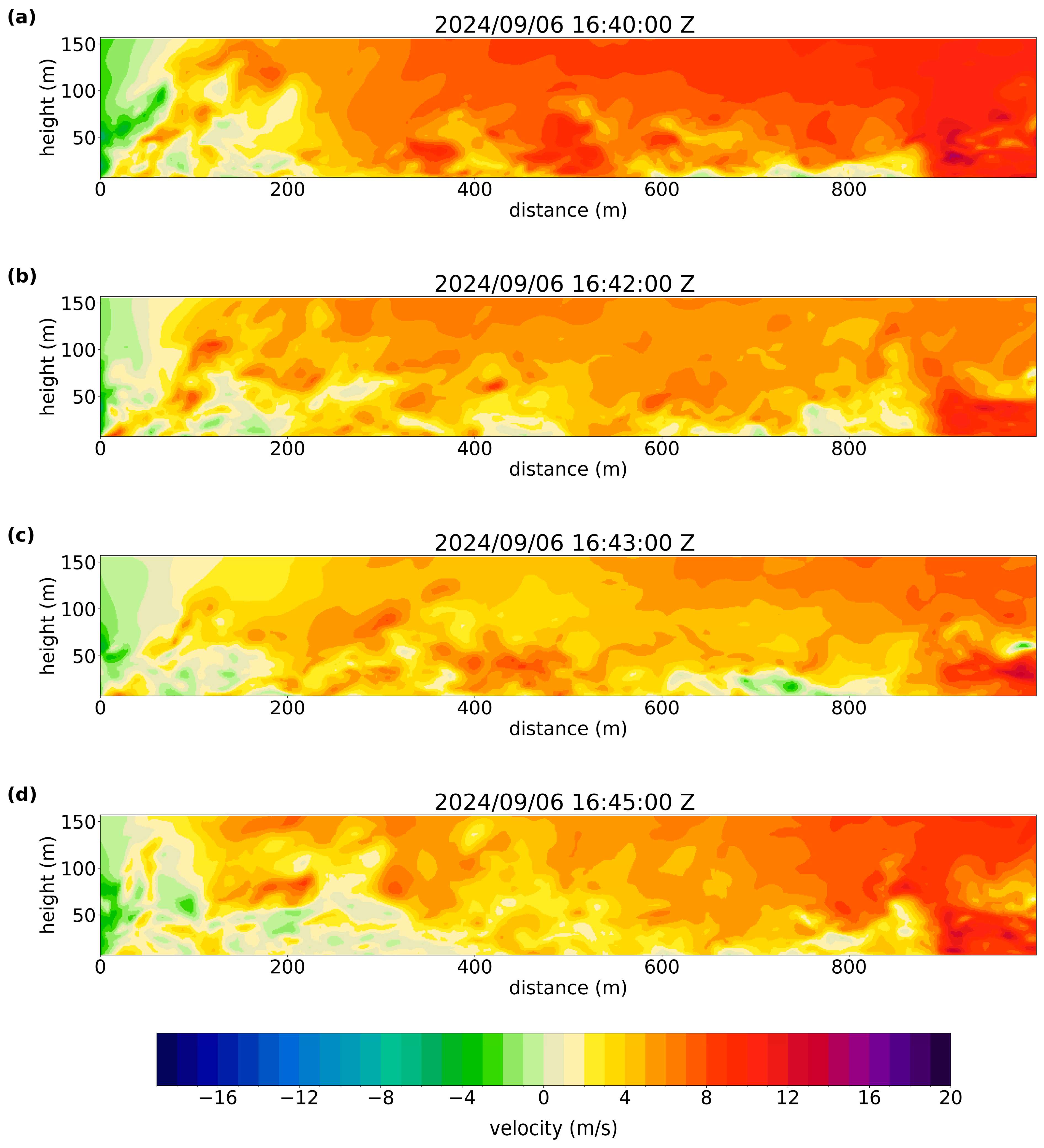
With the use of PALM, the reverse flow shows up nicely in the simulation, as shown in the time instances of Figure 12 based on a 2-hour simulation. Again, in general there is a decrease of prevailing wind speed from Figure 12(a) to Figure 12(b), and in the latter time reverse flow starts to occur at about 200 m and 800 m downstream of the LIDAR. Five minutes later (Figure 12(d)), the reverse flow occurs down to 400 m downstream of the LIDAR, and reaches a height of about 50 m, generally consistent with the actual observations (Figure 9(b)). The RAMS-PALM coupled results do capture the rapidly evolving airflow.
7. Conclusions
In the present paper, two sets of RHI observations by remote-sensing meteorological equipment are studied, namely, for Super Typhoon Saola using SLW radar, and Super Typhoon Yagi using GFS LIDAR. They display rapid airflow disturbances, with high turbulence and generally wavy motion extending up to a height of 4000 m to 6000 m above sea level. Such disturbances could be hazardous to the operation of the aircraft.
Using high resolution numerical simulations, it is possible to forecast the evolution of the wave field several hours in advance. This opens up the possibility of predicting airflow disturbances associated with complex terrain and buildings at an operating airport. More cases of disturbed airflow would be observed in the future and reported in the papers.
References
- Chan, P.W. (2014): Observation and numerical simulation of vortex/wave shedding for terrain-disrupted airflow at Hong Kong International Airport during Typhoon Nesat in 2011. Meteorological Applications, 21, 512–520. [CrossRef]
- Chan, P.W., Zhang, Y., and Doviak, R.J. (2016). Calculation and application of eddy dissipation rate map based on spectrum width data of a S-band radar in Hong Kong. MAUSAM, 67, 411-422. [CrossRef]
- Chan, P.W, Cheung, P., and Lai, K.K. (2024). Observation and numerical simulation of terrain-induced airflow leading to low level windshear at the Hong Kong International Airport based on Range-Height-Indicator scans of a LIDAR. Meteorologische Zeitschrift, 33, 2024. [CrossRef]
- Chan, Y.W., Chen, H., Chen, C., Xu, Y., Chan, P.W., Zhao, K., Yang, Z. (2024). Application of three-dimensional wind fields and dual-polarisation signals of an X-band Phased Array Weather Radar in diagnosing vertical motion and cloud electrification of convective storms. Adv. Atmos. Sci. [CrossRef]
- Deardorff, J.W. (1980). Stratocumulus-capped mixed layers derived from a three-dimensional model. Boundary Layer Meteorology, 18, 495-527. [CrossRef]
- He, J., Chan, P.W., Chan, Y.W., Cheung, P. (2023). Super Typhoon Saola (2023) over the northern part of the South China Sea — aircraft data analysis. Atmosphere, 14, 1595. [CrossRef]
- Kim, Y.; Castro, I.P.; Xie, Z.-T. (2013). Divergence-free turbulence inflow conditions for large-eddy simulations with incompressible flow solvers. Comput. Fluids, 84, 56–68. [CrossRef]
- Lo, K.W., Chan, P.W., Lai, K.K. (2024a). Observations and simulations of the winds at a bridge in Hong Kong during two tropical cyclone events in 2023. Applied Sciences, 14, 7789. [CrossRef]
- Lo, K.W., Chan, P.W., Lai, K.K., Lau, S.P.W., Zhao, Z.H. (2024b). Case studies of the winds in the urban area of Hong Kong – microclimate station observations and high resolution numerical simulations. Heliyon, 10, e37865. [CrossRef]
- Maronga, B.; Banzhaf, S.; Burmeister, C.; Esch, T.; Forkel, R.; Fröhlich, D.; Fuka, V.; Gehrke, K.F.; Geletič, J.; Giersch, S. (2020). Overview of the PALM model system 6.0. Geosci. Model Dev., 13, 1335–1372. [CrossRef]
- Maronga, B.; Gryschka, M.; Heinze, R.; Hoffmann, F.; Kanani-Sühring, F.; Keck, M.; Ketelsen, K.; Letzel, M.O.; Sühring, M.; Raasch, S. (2015). The Parallelized Large-Eddy Simulation Model (PALM) version 4.0 for atmospheric and oceanic flows: Model formulation, recent developments, and future perspectives. Geosci. Model Dev., 8, 2515–2551. [CrossRef]
- Raasch, S.; Schröter, M. (2001). PALM—A large-eddy simulation model performing on massively parallel computers. Meteorol. Z., 10, 363–372. [CrossRef]
- Smagorinsky, J. (1963). General circulation experiments with the primitive equations. Part I, the basic experiment. Monthly Weather Review, 91, 99-164.
- Wicker, L.J.; Skamarock, W.C. (2002). Time-Splitting Methods for Elastic Models Using Forward Time Schemes. Mon. Weather Rev., 130, 2088–2097. [CrossRef]
- Williamson, J.H. (1980). Low-storage Runge-Kutta schemes. J. Comput. Phys., 35, 48–56. [CrossRef]
- Xie, Z.-T.; Castro, I.P. (2008). Efficient Generation of Inflow Conditions for Large Eddy Simulation of Street-Scale Flows. Flow Turbul. Combust., 81, 449–470. [CrossRef]
Figure 1.
(a) The surface synoptic chart at 0200 Hong Kong time on 2 September 2023 and (b) The surface synoptic chart at 0200 Hong Kong time on 7 September 2024.
Figure 1.
(a) The surface synoptic chart at 0200 Hong Kong time on 2 September 2023 and (b) The surface synoptic chart at 0200 Hong Kong time on 7 September 2024.
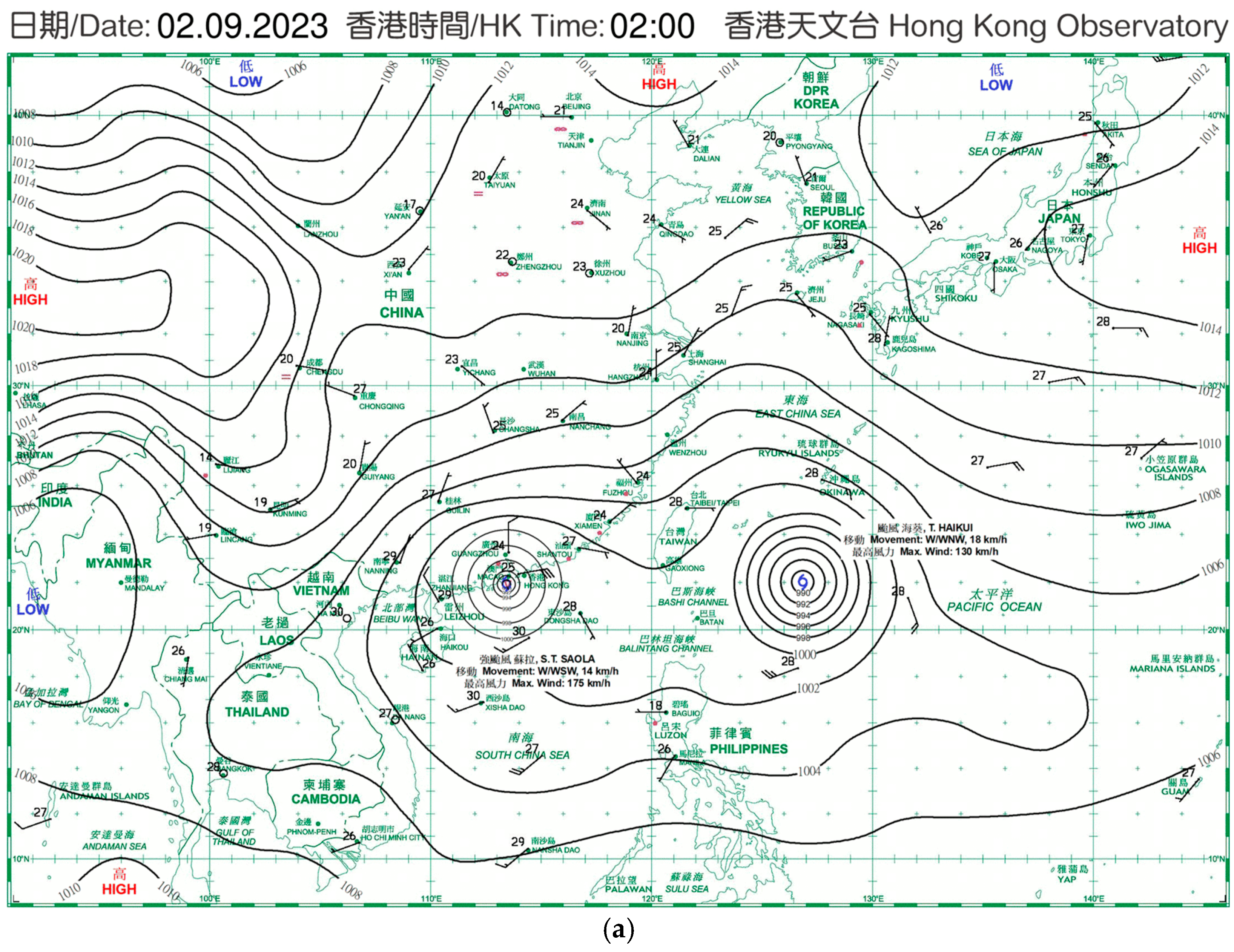
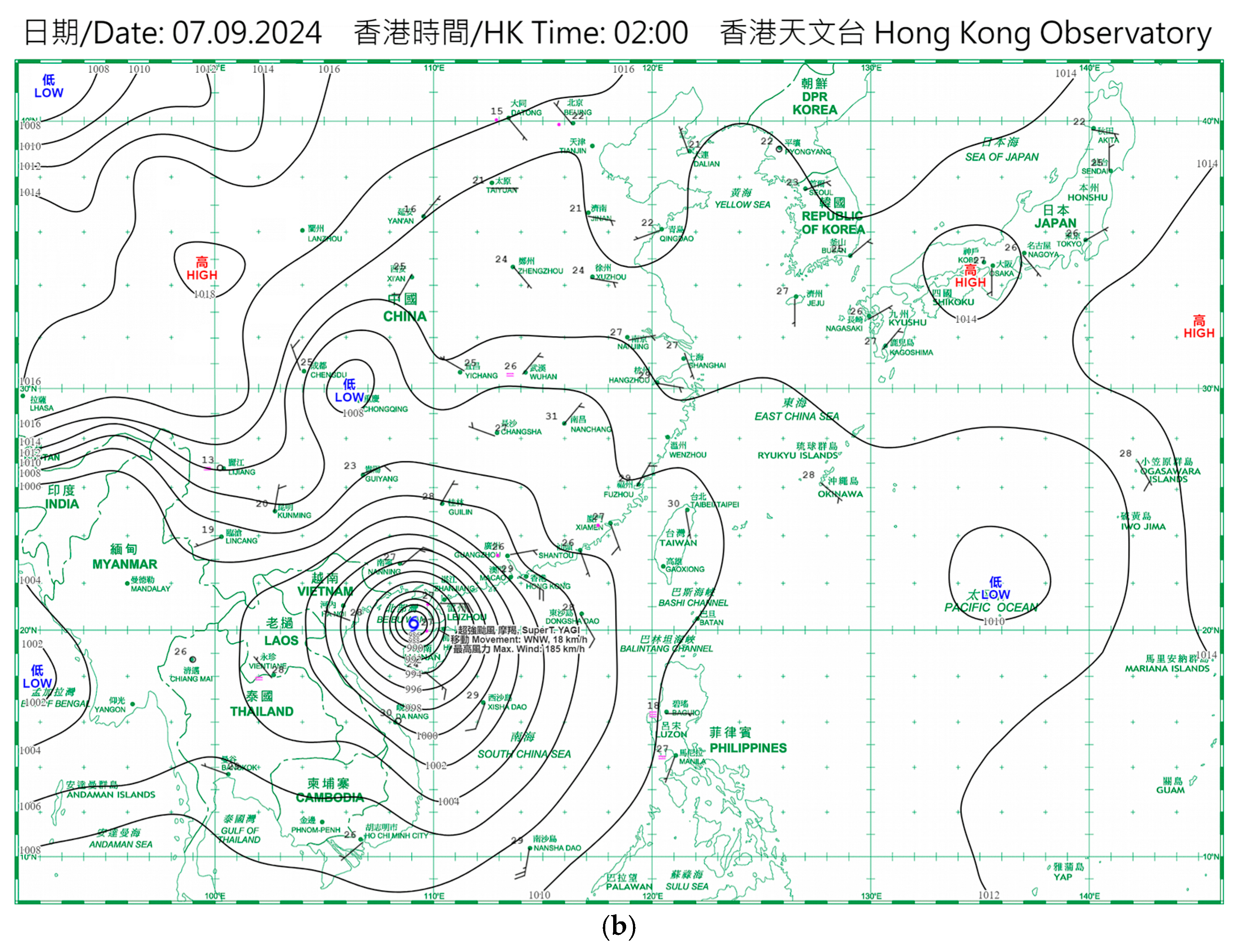
Figure 2.
The locations of X-band dual polarisation Phased Array Weather Radar (PAWR) and wind profiler at Sha Lo Wan (SLW) as well as the short-range LIDAR at the Government Flying Service (GFS) Headquarters at the Hong Kong International Airport (HKIA).
Figure 2.
The locations of X-band dual polarisation Phased Array Weather Radar (PAWR) and wind profiler at Sha Lo Wan (SLW) as well as the short-range LIDAR at the Government Flying Service (GFS) Headquarters at the Hong Kong International Airport (HKIA).
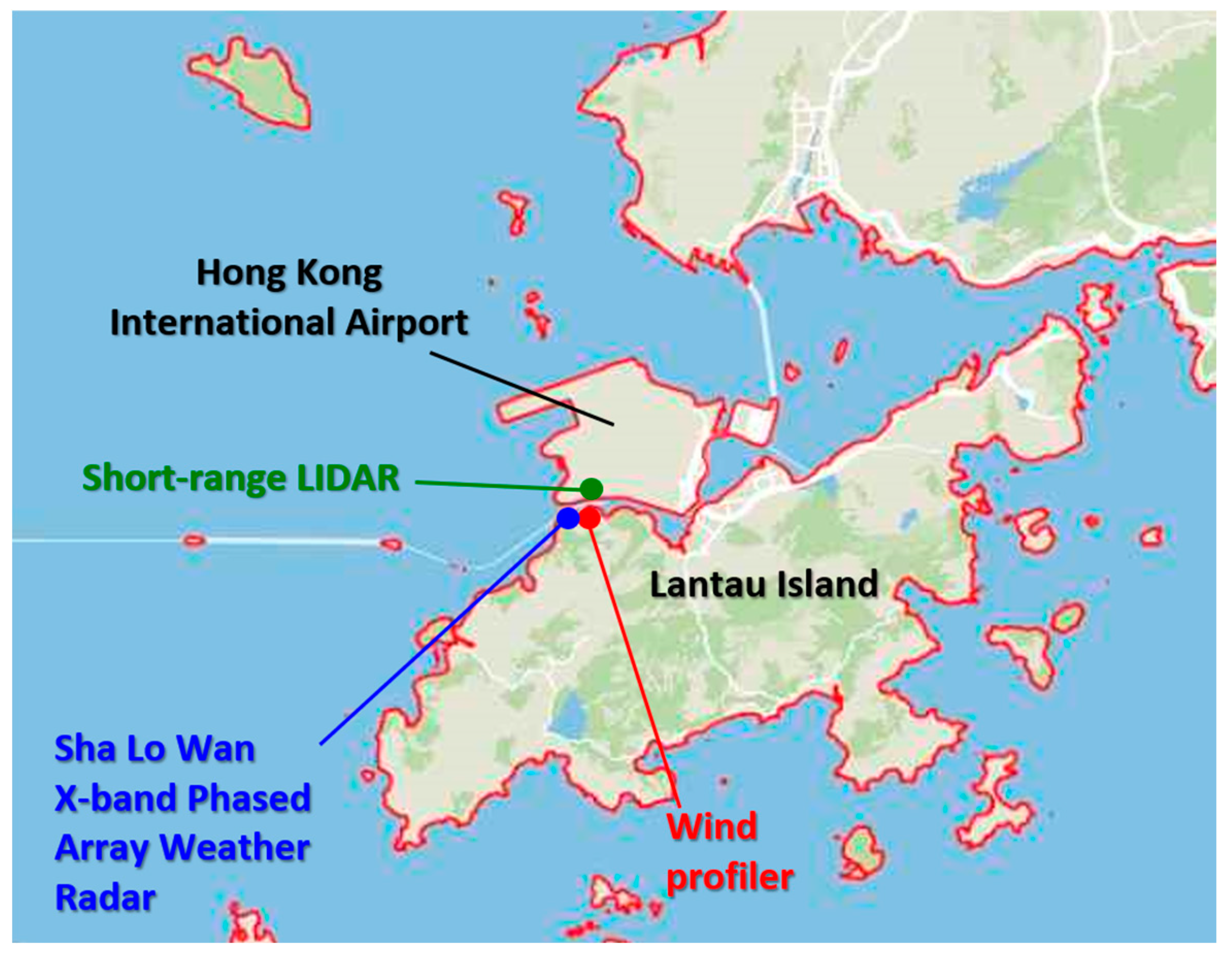
Figure 3.
(a) The RHI spectral width scan and (b) the associated cross-section of eddy dissipation rate (EDR) as well as (c) three dimensional wind fields (Left: horizontal wind field at height of around 34 m above sea level. Right: wind field projected on the cross-sectional plane A-B on the left panel) obtained/retrieved using SLW radar data at around 0255 Hong Kong time on 2 September 2023.
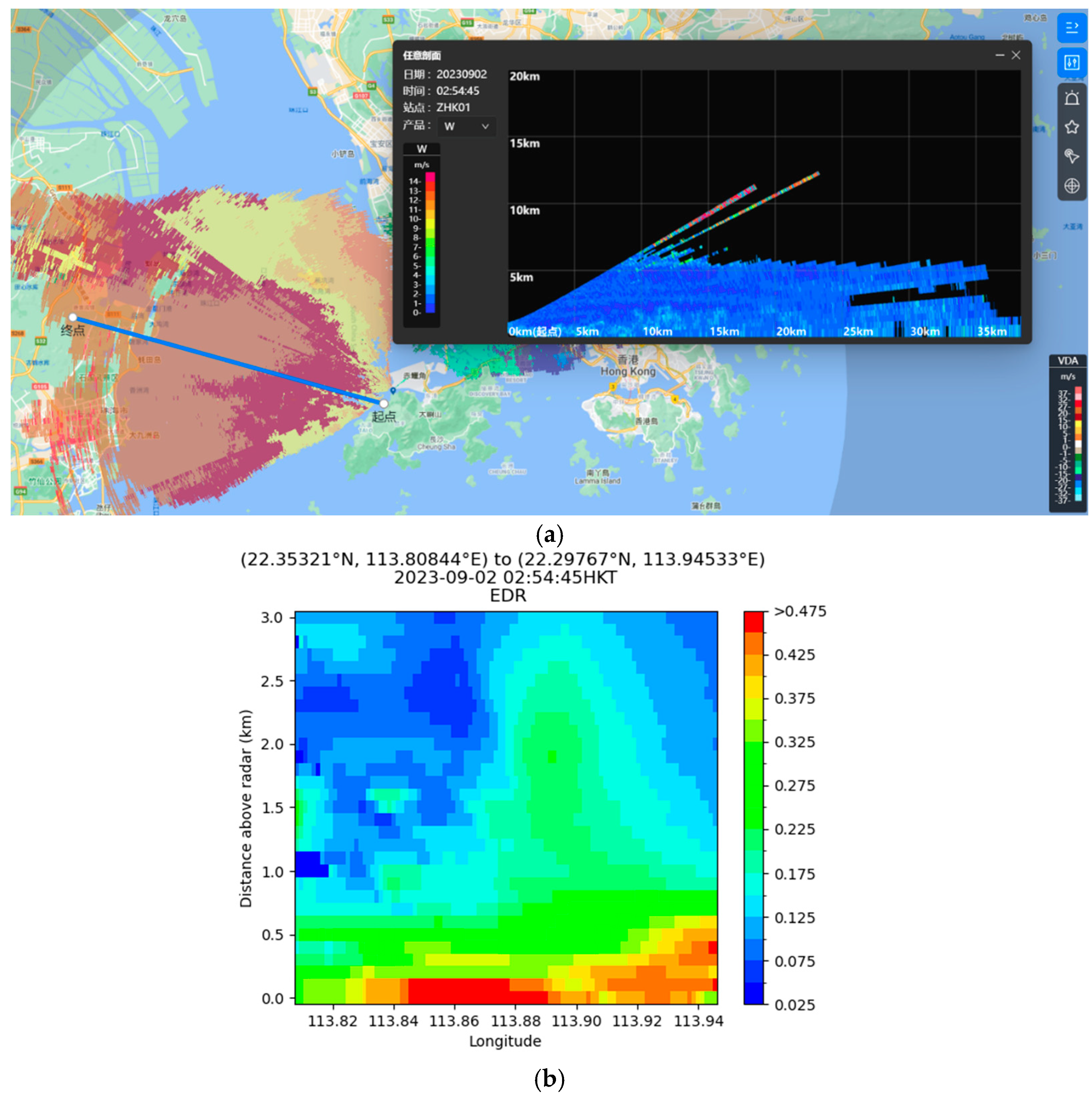
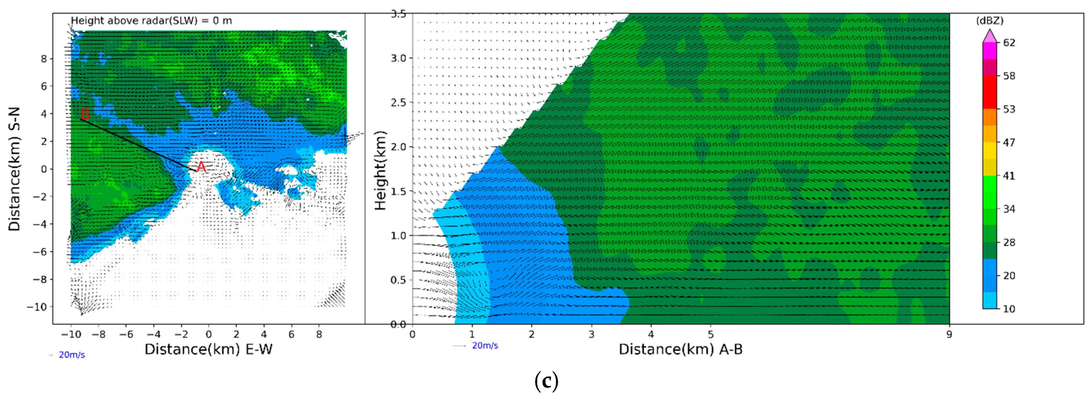
Figure 4.
(a) The RHI spectral width scan and (b) the associated cross-section of eddy dissipation rate (EDR) as well as (c) three dimensional wind fields (Left: horizontal wind field at height of around 34 m above sea level. Right: wind field projected on the cross-sectional plane A-B on the left panel) obtained/retrieved using SLW radar data at around 0305 Hong Kong time on 2 September 2023.
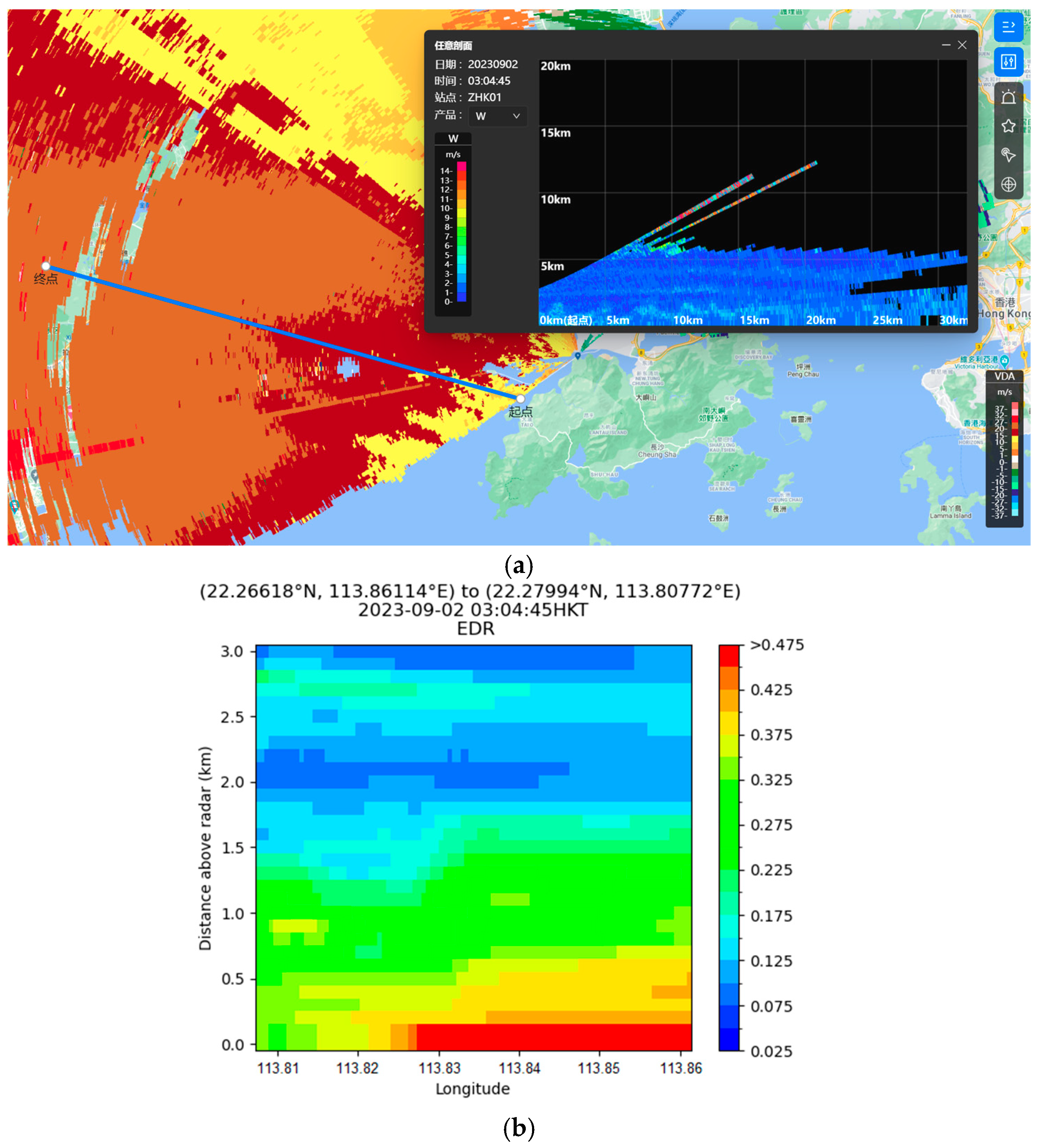
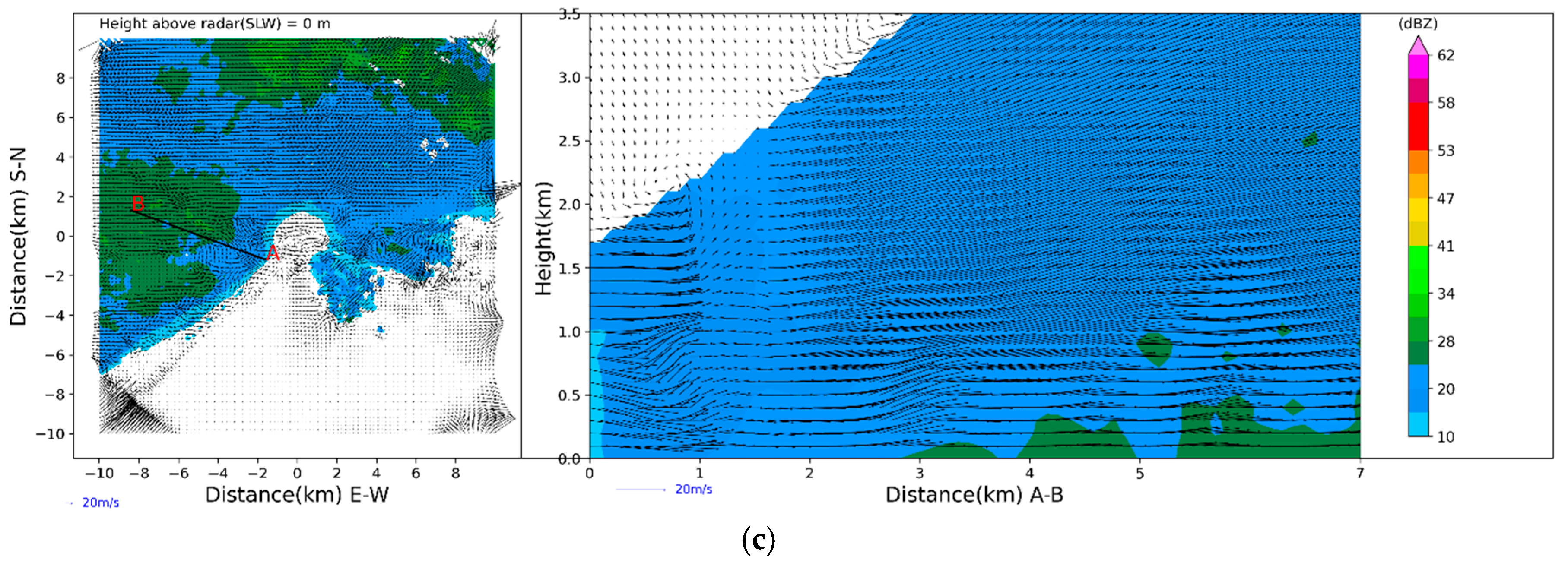
Figure 5.
(a) The 1st, 2nd and 3rd nested domain of RAMS simulation. (b) The 3rd, 4th and 5th nested domain of RAMS simulation.
Figure 5.
(a) The 1st, 2nd and 3rd nested domain of RAMS simulation. (b) The 3rd, 4th and 5th nested domain of RAMS simulation.
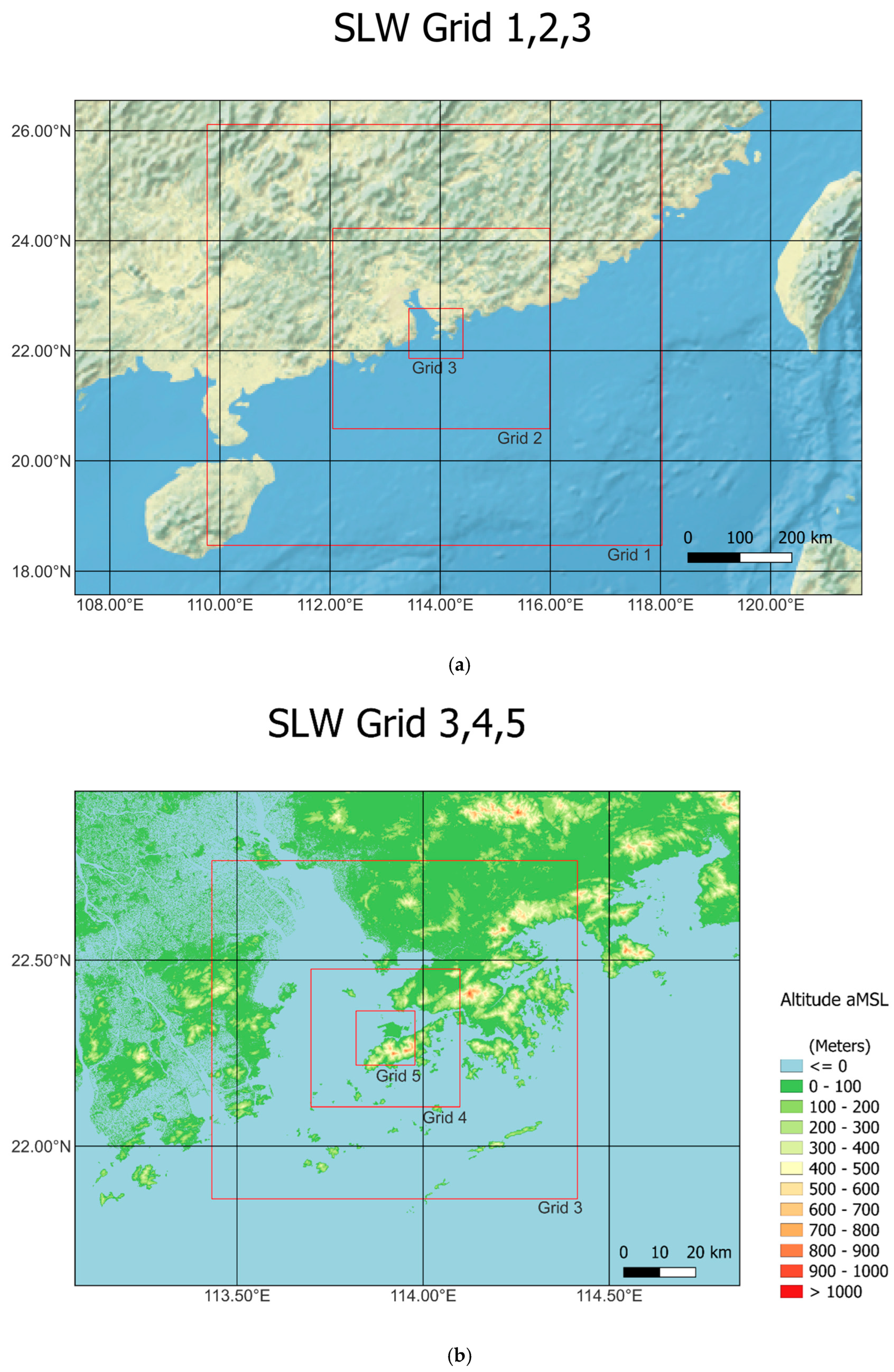
Figure 6.
(a) Observations of horizontal wind profiles from SLW wind profiler from 18:00 Hong Kong time on 1 September 2023 to 06:00 Hong Kong Time on 2 September 2023 (+8 UTC). (b) Simulated horizontal wind profiles (wind barbs) and vertical velocities (background color) from RAMS on 1 September 2023 from 15UTC to 22UTC.
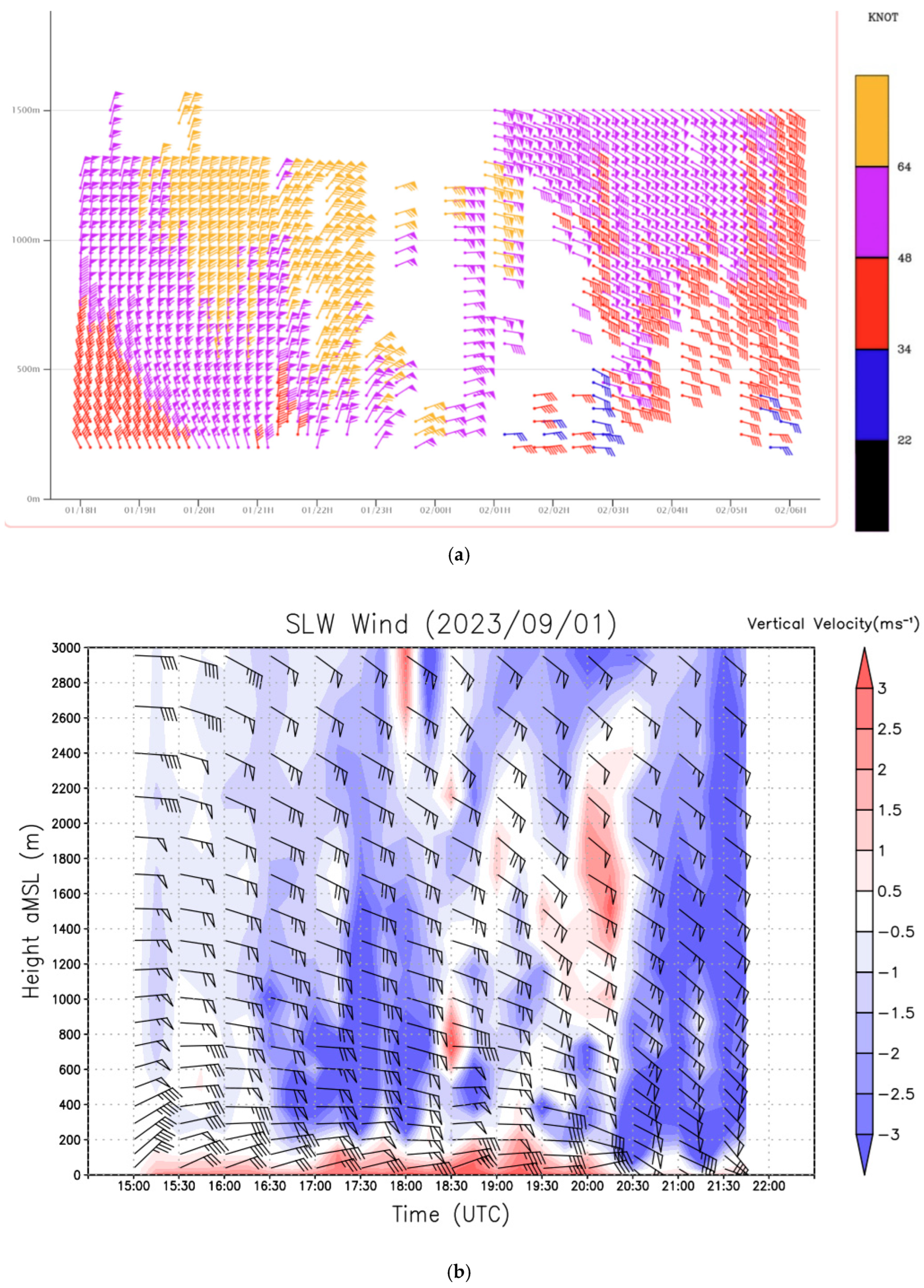
Figure 7.
Simulation of RHI scans of (a) EDR and (b) wind field from RAMS on 18:54:10 UTC, 1 September 2023.
Figure 7.
Simulation of RHI scans of (a) EDR and (b) wind field from RAMS on 18:54:10 UTC, 1 September 2023.
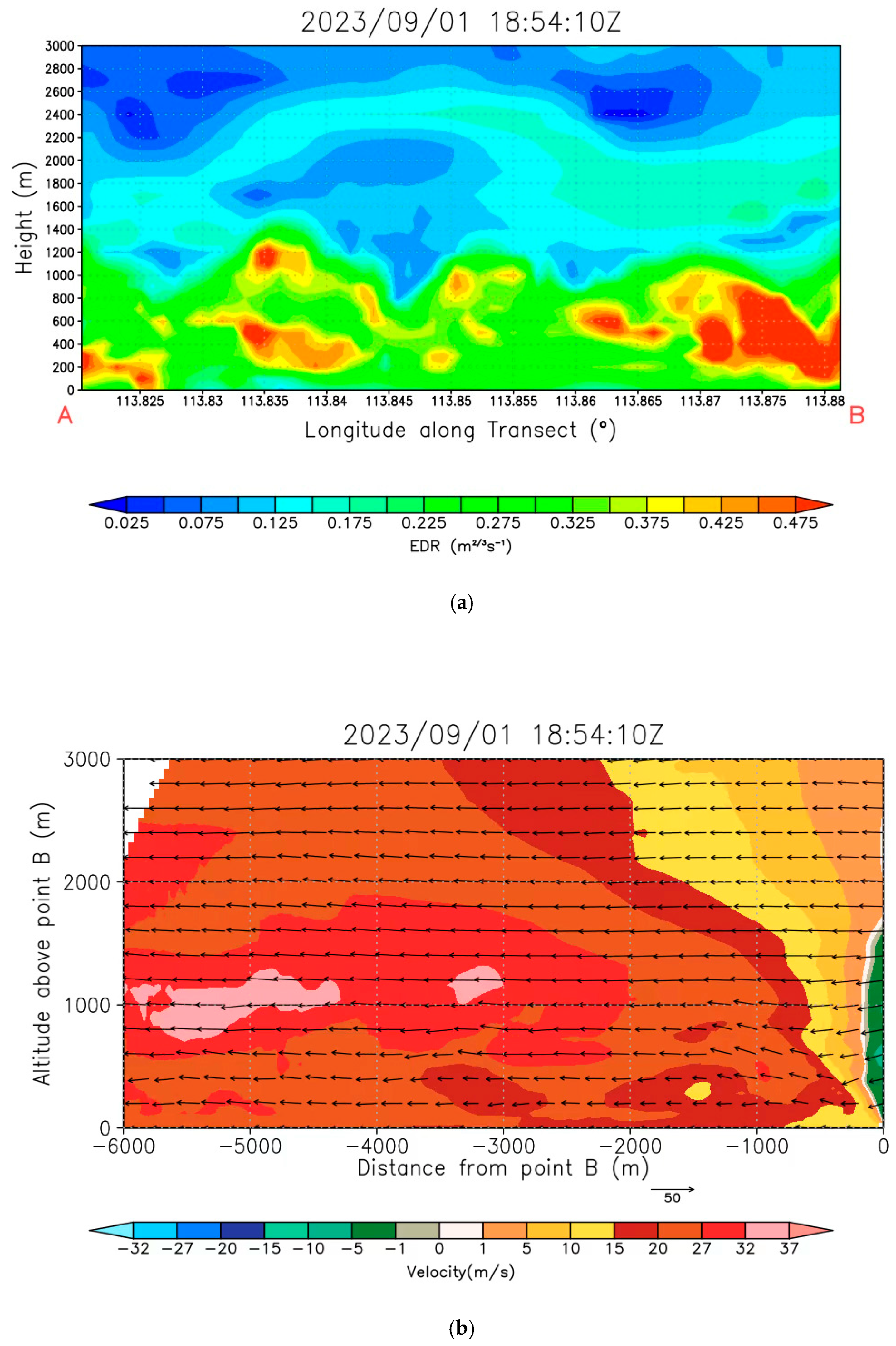
Figure 8.
(a) The domain of PALM simulation denoted by red rectangle where the boundary is the 5th nested domain of RAMS simulation. The blue line indicates the location of the RHI scan of GFS LIDAR. (b) PALM simulation domain with building heights indicated by the colorbar. The blue cross symbol indicates the location of GFS LIDAR and the blue line shows the location of its RHI scan.
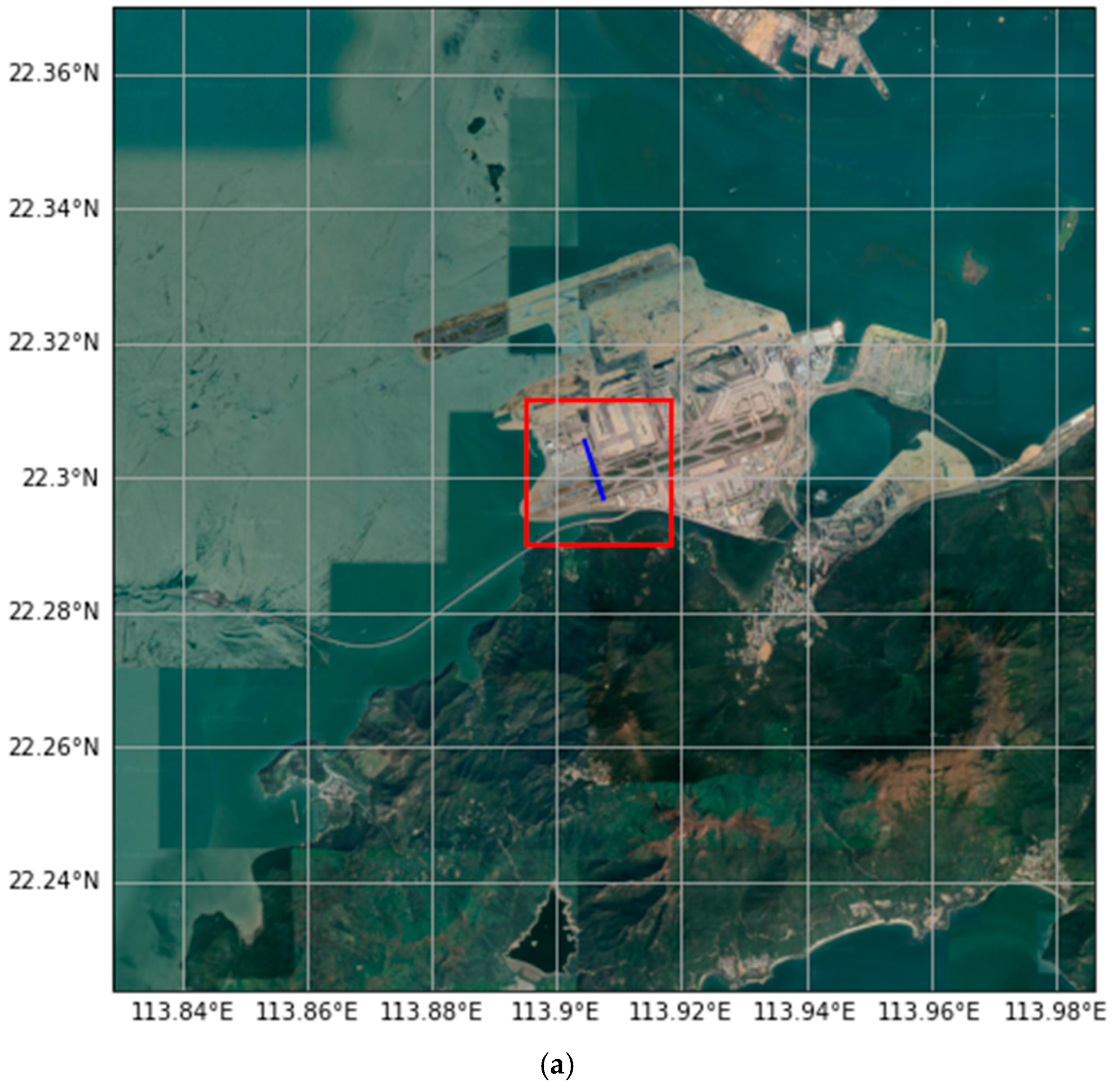
Figure 9.
(a) RHI scans of radial wind velocity from GFS LIDAR at 00:40:18 Hong Kong Time (+8 UTC), on 7 September 2024. (b) RHI scans of radial wind velocity from GFS LIDAR at 00:42:36 Hong Kong Time (+8 UTC), on 7 September 2024.
Figure 9.
(a) RHI scans of radial wind velocity from GFS LIDAR at 00:40:18 Hong Kong Time (+8 UTC), on 7 September 2024. (b) RHI scans of radial wind velocity from GFS LIDAR at 00:42:36 Hong Kong Time (+8 UTC), on 7 September 2024.
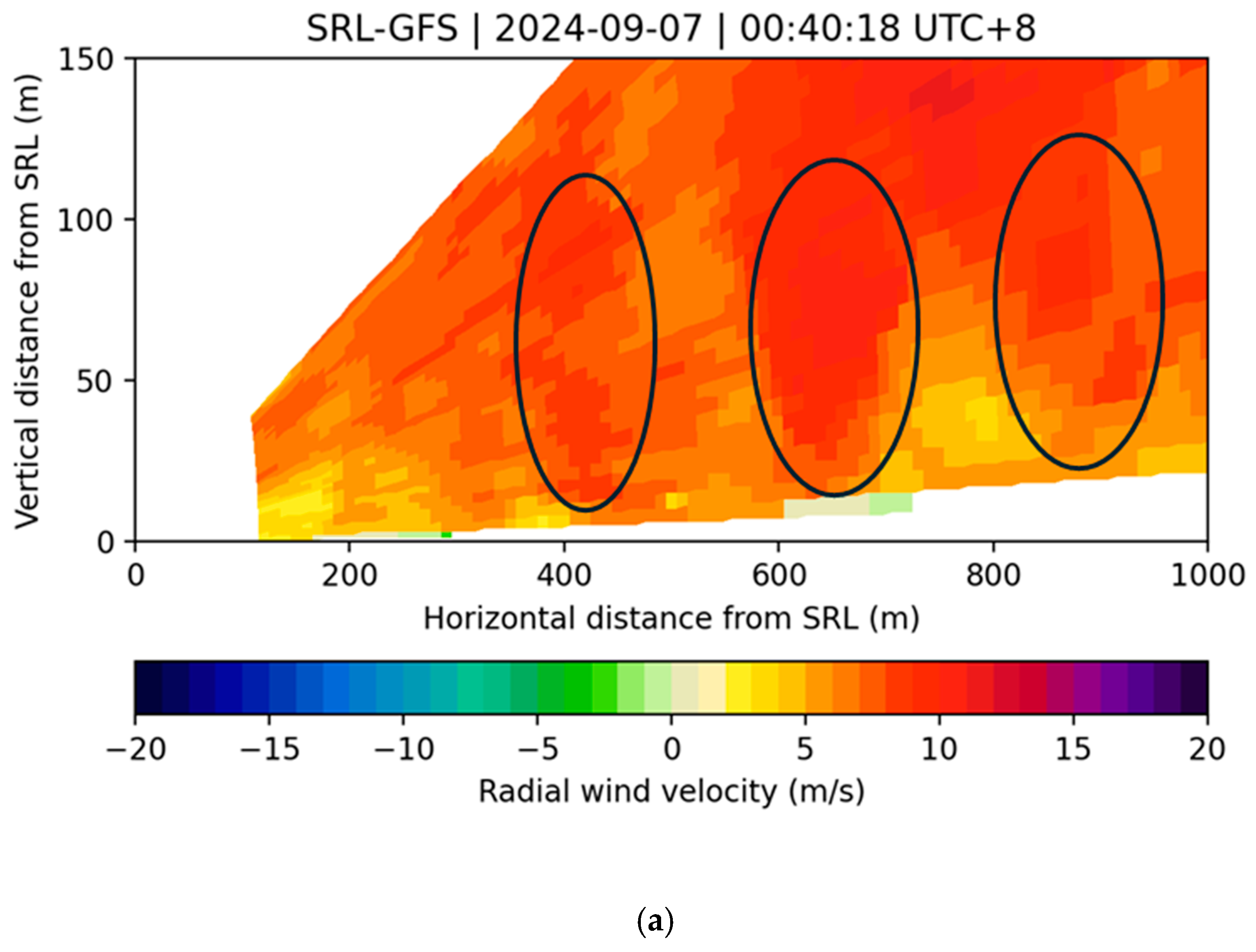
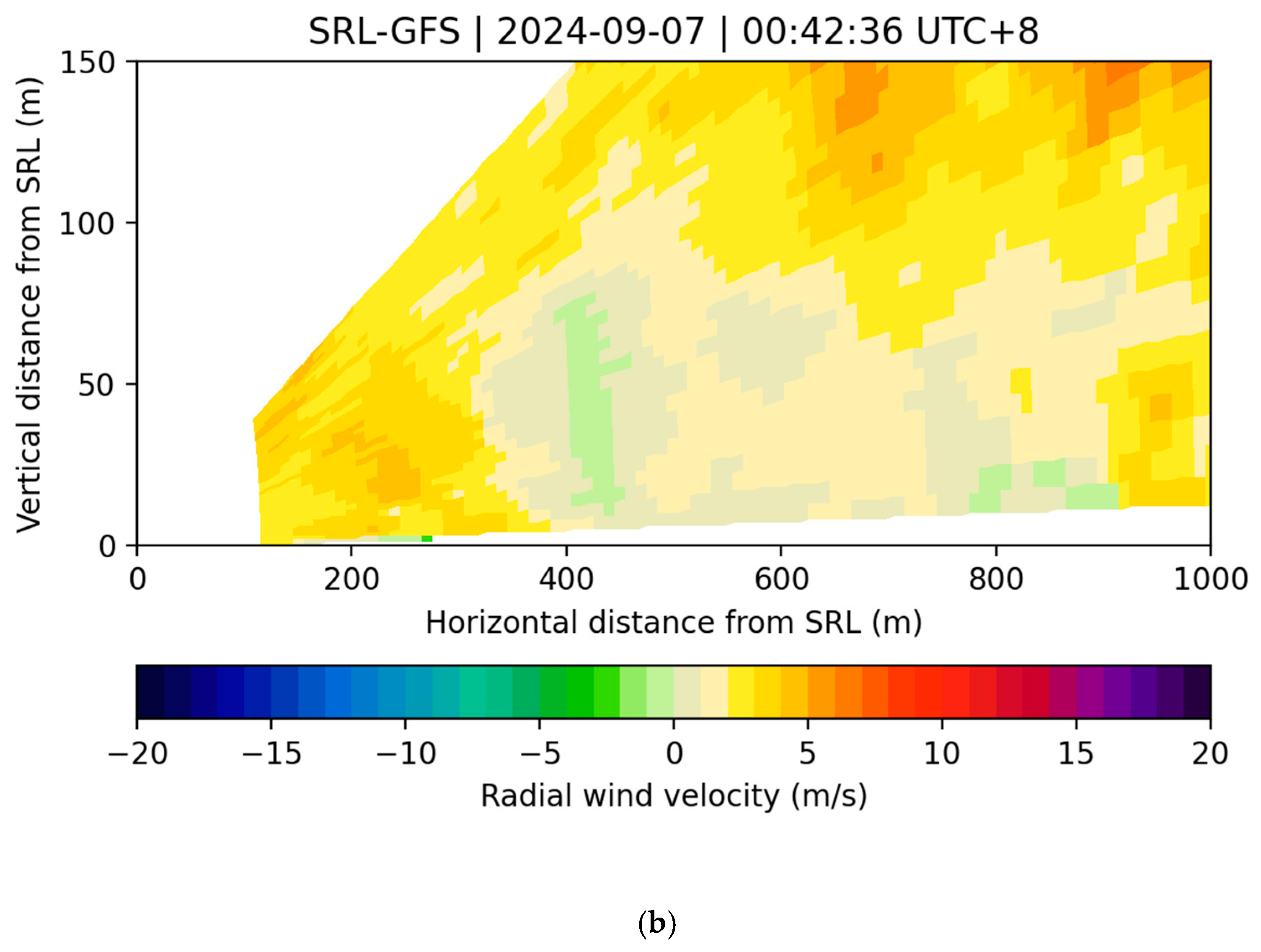
Figure 10.
(a) RAMS Simulation for RHI scans of radial wind velocity from GFS LIDAR at 16:40:10 UTC, on 6 September 2024. (b) RAMS Simulation for RHI scans of radial wind velocity from GFS LIDAR at 16:43:40 UTC, on 6 September 2024.
Figure 10.
(a) RAMS Simulation for RHI scans of radial wind velocity from GFS LIDAR at 16:40:10 UTC, on 6 September 2024. (b) RAMS Simulation for RHI scans of radial wind velocity from GFS LIDAR at 16:43:40 UTC, on 6 September 2024.
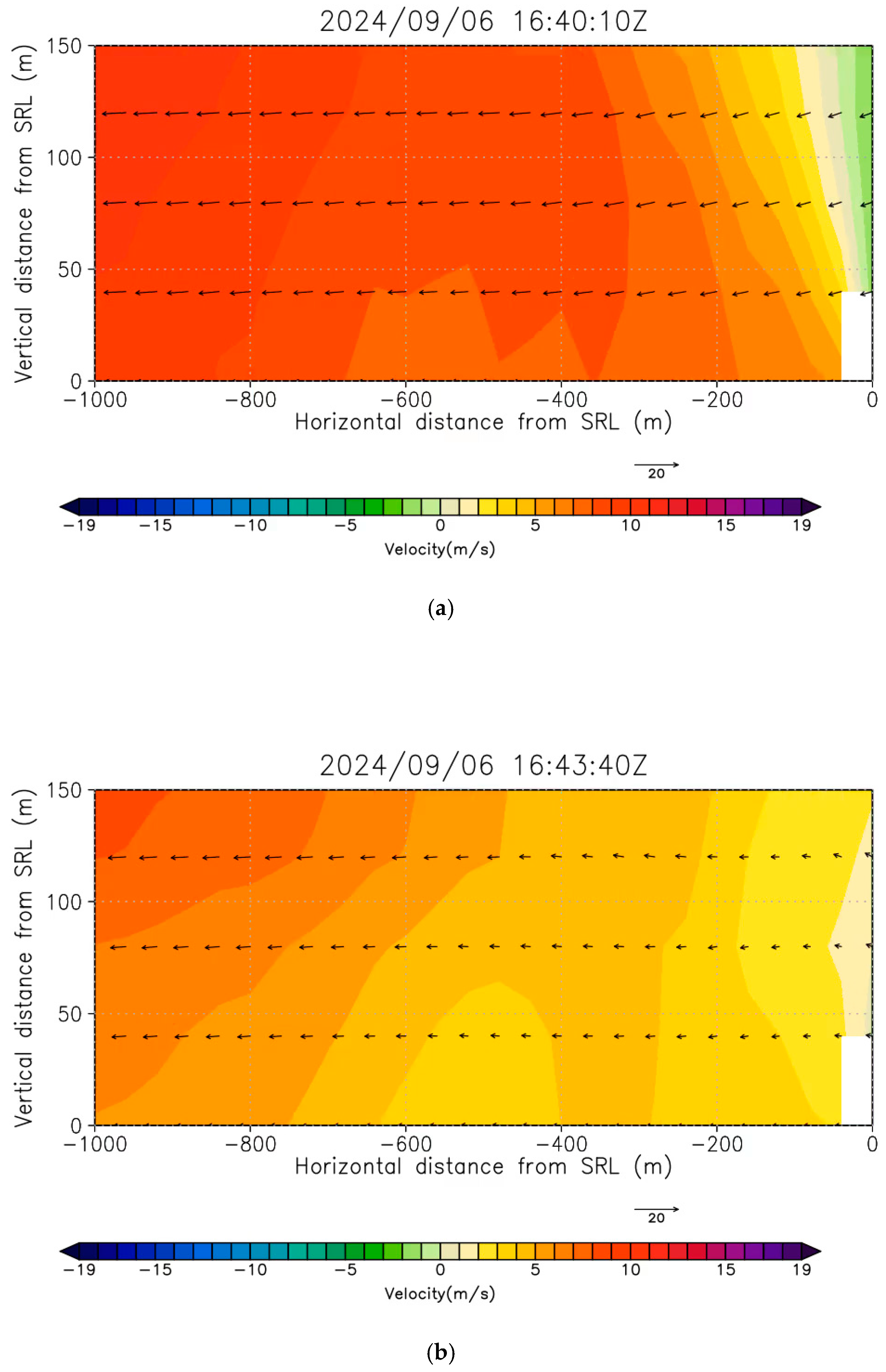
Figure 11.
RAMS simulation of radial wind velocity from GFS LIDAR with extended range at 16:40:10 UTC, on 6 September 2024.
Figure 11.
RAMS simulation of radial wind velocity from GFS LIDAR with extended range at 16:40:10 UTC, on 6 September 2024.
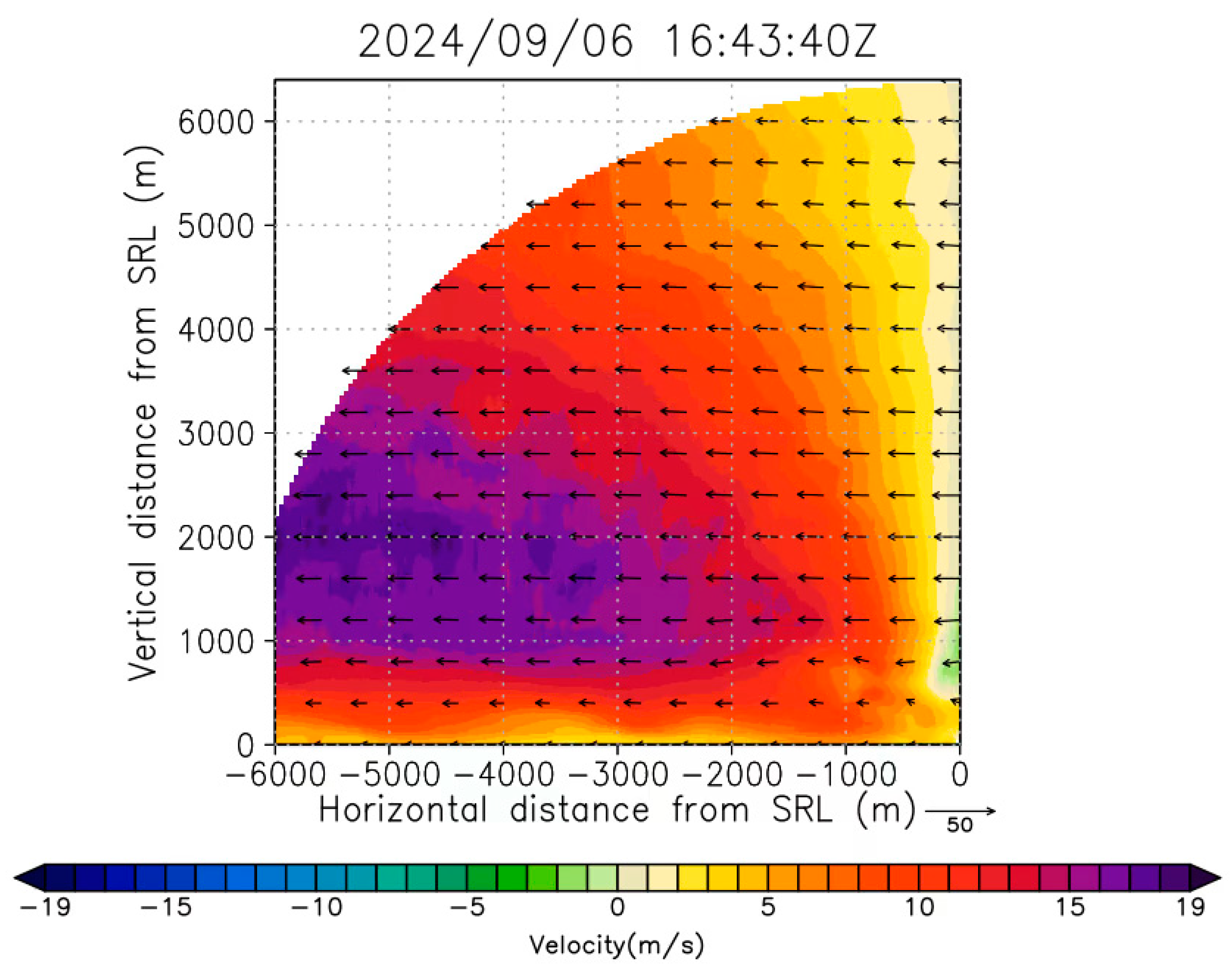
Figure 12.
PALM simulation for RHI scans of radial wind velocity from GFS LIDAR at four different instances: (a) 16:40UTC, (b)16:42 UTC, (c)16:43 UTC and (d) 16:45 UTC on 6 September 2024.
Figure 12.
PALM simulation for RHI scans of radial wind velocity from GFS LIDAR at four different instances: (a) 16:40UTC, (b)16:42 UTC, (c)16:43 UTC and (d) 16:45 UTC on 6 September 2024.
Disclaimer/Publisher’s Note: The statements, opinions and data contained in all publications are solely those of the individual author(s) and contributor(s) and not of MDPI and/or the editor(s). MDPI and/or the editor(s) disclaim responsibility for any injury to people or property resulting from any ideas, methods, instructions or products referred to in the content. |
© 2024 by the authors. Licensee MDPI, Basel, Switzerland. This article is an open access article distributed under the terms and conditions of the Creative Commons Attribution (CC BY) license (http://creativecommons.org/licenses/by/4.0/).
Copyright: This open access article is published under a Creative Commons CC BY 4.0 license, which permit the free download, distribution, and reuse, provided that the author and preprint are cited in any reuse.


