1. Introduction
The soil's behavior under dynamic conditions and its response to strong ground shaking are among the most essential focuses in seismic hazard investigation. In a granular layer of no cemented sediments, the liquefaction process transforms it into a liquid state and characteristics of a solid-state mass. That is possible because the pore-water pressure is increased under cycling stress or shaking [
1,
2].
The liquefaction processes in areas where the conditions of saturation and phreatic levels are close to the surface (including sequences of fine to medium granular materials like sands and silts) are one of the main causes of damage and collapse of buildings and infrastructures when dynamic stresses occur in the event of an earthquake [
3]. However, some features can vary from one plate to another, such as grain size and distribution, geometry and dimension, density, fine contents, and/or limit constraints of the deposit or layers. All these involve anomalous propagation (including amplification) of the seismic waves at the surface of land [
4].
In Ecuador, where the seismic hazard is high in all the territory, these saturated granular terrains, especially the recent sediments, have a wide propensity to liquefy in the event of an earthquake event, as it happened on April 16, 2016, in the Pedernales-Muisne earthquake [
5]. So, probability analysis of liquefaction susceptibility is a vital investigation when the vulnerability affects, for example, earthen dams, with damage and failure occurring to varying degrees in dams worldwide [
6].
In the natural lagoon of San Marcos, Cayambe Canton (Pichincha Province of Ecuador), a loose materials dam has been built and put into operation as a water reservoir for irrigation and drinking water. In this area, various investigations have been carried out both for the construction and about to natural hazards by the owner of the infrastructure, the Decentralized Autonomous Government of the Province of Pichincha, from now on GADPP [
7]. In 2018, Torres [
8] studied and defined the hazards related to volcanism and seismicity for said dam, evidencing the acceleration of the terrain on which the dam is founded and the possible effects of an eruption of the nearby Cayambe volcano. Subsequently, Alonso-Pandavenes et al. [
9] carried out investigations on the axis and foot of the dam in order to determine and define the position and geometry of the rock basement using passive seismic techniques through the use of the Horizontal to Vertical Spectral Ratio (HVSR) and its correlation with the previous drilling performed for investigation of the area [
10].
The work developed by Torres [
8] preliminarily assessed the possible liquefaction potential based on the SPT field tests performed in the exploration boreholes carried out for the construction of the infrastructure (personal communication; the corresponding report is not available). However, in the central area of the dam and the valley of the Azuela River, where it is located, these drilling and tests did not reach the rock basement (which is located at a greater depth than the 80 m explored) and could only be applied SPT tests up to 30 m depth. From this level, pyroclastic-type materials with a sandy matrix and the presence of thick boulders have appeared and prevented the execution of those type of geotechnical tests [
7].
The present investigation will allow us to analyze, based on the results of the fundamental frequency of ground vibration (
fo) and its associated amplification (
Ao), the potential or susceptibility of liquefaction of the ground at the base and surrounding areas of the San Marcos dam. It also intends to define areas around the dam with a propensity and possibility of liquefaction conditions arising under earthquake events. This analysis will be carried out using the so-called
Kg Vulnerability Index [
11] and its relationship with ground shear strain (
GSS), also defined by Nakamura in 1997[
12]. So, it can demonstrate the efficacy, cost, and time economy of a simple survey in showing the sites beneath liquefaction that will be produced and at the maximum intensity that can occur. In the most vulnerable areas, an assessment of said liquefaction capacity will be carried out to demonstrate and corroborate the data obtained through seismic tests and analysis based on the impact data from the SPT tests of the existing drillings and their potential to suffer this type of phenomenon.
2. Geographical Setting and Geological Framework
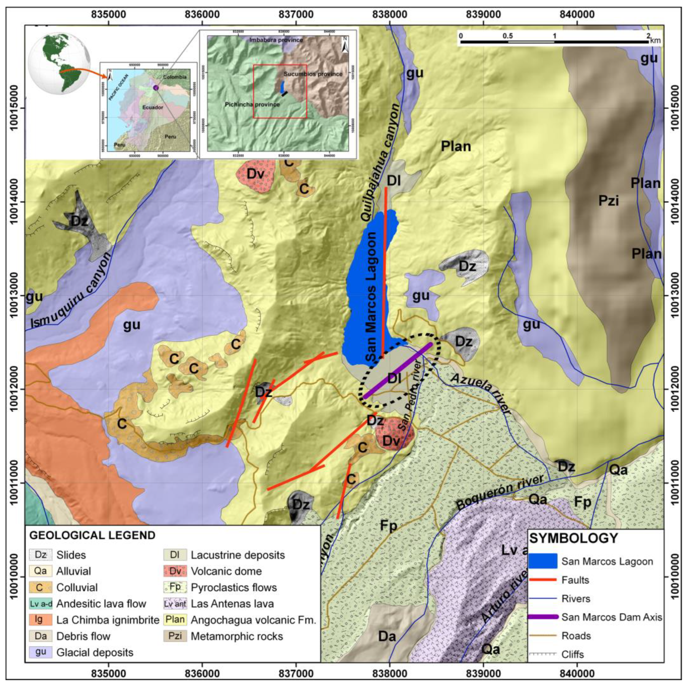
The area under investigation is located north-northeast of the Cayambe volcano, between the Pichincha and Napo provinces (Ecuador). That is a mountainous area close to the head of a glacial origin valley (circus) called the Azuela River, which is the most important watercourse in the area. The surficial deposits of the valley are dominated by fluvioglacial, volcanic, and volcaniclastic origin sediments that come from the recent eruptions of the nearby volcano, located less than 10 km from the study area (
Figure 1, Cayambe volcano is out of the image to the southwest and is not shown in this cartography) [
8].
For the hydraulic use of the existing natural lagoon (called Laguna de San Marcos), an earth dam with a height of 17 m high from the natural terrain and a length of 738 m at the crest was built [
7].
The local geology of the dam area is dominated by the presence of a Pleistocene rocky basement delineated by Alonso-Pandavenes et al. [
9] and composed of lavas and compact and cemented volcanic products (lavas, breccias, and tuffs) belonging to the Angochagua Formation (
Figure 1). Several stratigraphic sequences of younger sediments have been deposited on top of these materials, referred to as the Cayambe Volcanic Formation. This formation originated in the nearby volcano and reached its most significant expression during the “San Marcos-type” eruption that occurred in the area about 4000 years ago. This eruptive event led to the deposition of pyroclastic material at the bottom that closed the valley and naturally dammed the water, starting the creation of the current San Marcos Lagoon [
8,
13].
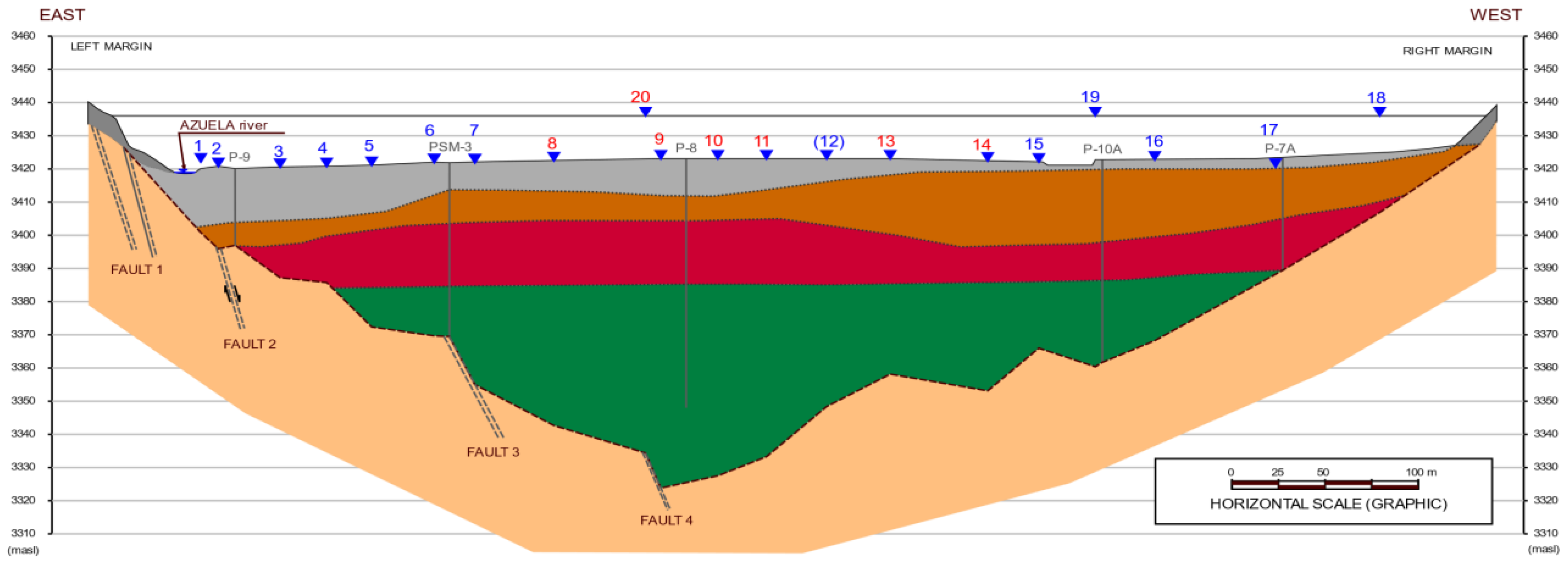
Subsequently, and more recently, transported sediments were deposited in solid (glacial) or aqueous (alluvial and lacustrine) phases, which have shaped the current morphology of this area (
Figure 2). These materials form a stratigraphic sequence in the area of the dam construction with a column of more than 35 m (in the central area, it exceeds 40 m), with predominant alluvial and lacustrine sediments intercalated (distal flow or low intensity) overlaying the pyroclastic material of the Cayambe Volcanics Formation [
8,
9].
Regarding the tectonic structure of the dam construction area, the definition of faults and folds has not been wholly determined in previous studies due to the presence of thick and recent covering materials that mask these features. Some of these structural elements have been mapped and determined by Torres [
8] and completed and defined in the Alonso-Pandavenes et al. [
9] research.
The direction of these major structures identified in these studies is consistent with the deformation processes generated by the subduction zone of the western coast of Ecuador, where the Nazca plate subducts the South American plate [
14]. This tectonic activity, together with nearby volcanic activity (for example, the Cayambe volcano resumed its activity for a few months in the period from 2016 to 2017) are the main focus of seismicity and earthquakes in the area [
8,
14,
15].
The area and surroundings of the San Marcos dam are located in a high seismic risk zone, according to the definition and assessment included in the Ecuadorian Seismic Classification within the NEC-SE-DS Ecuadorian Earthquake Resistant Standard [
16], the general value of rock acceleration (PGA) admitted and calculated by said standard for the study area being of the order of 300 Gal.
However, according to the Torres [
8] investigations through probabilistic and deterministic seismic hazard analysis (PSHA and DSHA), it has been confirmed that these seismic demand acceleration values for the foundation area of the San Marcos dam could reach 400 to 500 Gal due, above all, to the local effect which is also called site effect (amplification factors due to the presence of a thick sedimentary cover of low to medium compaction).
3. Methodology and Previous Knowledge
In 2009, the GADPP [
7] began designing and constructing a loose materials (earth) dam on the southern side of the San Marcos lagoon. This infrastructure, intended for damming water for irrigation and human consumption, is founded over the most superficial sediments of the fluvial-lacustrine type (see
Figure 2) on a flat artificial terrain improvement without constructing a lower curtain. The axis of the dike has a length of more than 700 m, with a southwest-northeast direction, and a height of 17 m above the area’s natural terrain (see location in
Figure 1).
Due to the morphological configuration of the valley where the dam is located (Azuela Valley), limited by compact rocky materials on both sides and pyroclastic materials in the bottom and towards the southeastern area, it can be considered that the area where the San Marcos dam is located has suitable conditions undrained for the materials that constitute its foundation and support.
In dynamic soil stresses, for example, those produced during an earthquake, cyclic loads occur that infer volume changes (decrease) in granular materials due to the reorganization of their particles. When the affected materials are saturated in undrained conditions, these loads are transmitted directly to the water, increasing pore pressure, which decreases the shear stress of the materials and their behavior like a liquid. That is known as the liquefaction phenomenon [
17].
Therefore, this soil behavior under dynamic stress will influence the stability and integrity of a structure or construction built on materials that can liquefy (soil-structure interaction), as is the case of the San Marcos dam. According to the data collected in the performed drilling for its design and construction, the most superficial part of the materials where the structure is founded has the main characteristics to exhibit liquefiable behavior. These materials are of a fine granular type (sands and silts that are not too compact) with a water table throughout the area at or close to the surface (less than 2.0 m depth, established in the surveys [
7]).
Based on laboratory tests and earthquake data, Ishihara's research [
18,
19] made it possible to relate the deformation between the shear stress and the dynamic properties of the terrain. These studies were the starting point for Nakamura [
12] to define his Vulnerability Index (
Kg) established from environmental vibration measurements through the formula:
where
e is the effectiveness,
fo is the value of the fundamental frequency of ground vibration,
Ao its associated amplification or the H/V spectral ratio value (last both obtained from the results of the processing of the HVSR tests and the analysis of the dispersion or ellipticity curve), and
Vb is the rocky basement shear-wave velocity [
12].
Considering a value of
e = 60% and a shear velocity = 600 m/s (Nakamura 1997 identifies that with the lower limit for the rock or basement), and so a constant value for all places (10
-6), this index would be defined in a simplified way, from Equation (2):
In that simplified form the
Kg value is used in most publications where the authors consider its results and the simplification useful, even Nakamura [
12,
20,
21,
22,
23,
24].
From this index (defined as “vulnerability” although it is not that term directly), it is possible to estimate the shear stress of the surface materials, which can be related to the potential impact that a dynamic stress (as an earthquake) can produce on the column of sedimented soil overlaying a basement (considering the area like a two-layer model). This
Kg index can then be applied in the study of soil liquefaction, or the potential initiation of a landslide, in the relationship established by Nakamura [
12] between the
Kg Vulnerability Index and the shear stress or deformation or Ground Shear Strength (
GSS) according to the equation:
where α would be the acceleration to which the ground is subjected in the event of an earthquake (expressed in Gal).
Figure 3 shows a distribution where the size of the deformation (
GSS) and the dynamic properties of the terrain are related, along with the phenomena that can develop due to said deformation. As observed, strain values greater than 10
-2 can produce landslides on soil slopes, compaction (in drained conditions), or liquefaction (in undrained conditions) and, thereby, contribute to collapse or damage to the soil interaction with an infrastructure [
19].
In the present investigation, this calculation technique will be used based on HVSR test measurements in the area of the bottom and crest of the San Marcos dam in order to assess the liquefaction potential of the study area. To do this, once the field data has been obtained and the ellipticity curves have been processed and analyzed, the value of the size of the deformation can be obtained by defining in the areas where a
GSS value (γ) > 10
-2 is seen, that these will have the capacity or potential for liquefaction phenomena to occur during a seismic event [
18,
19]. That does not mean these liquefaction phenomena will occur, even under the conditions considered in this study, since there may be variables in other factors and parameters not analyzed in the research. However, it is an assessment to keep in mind in the future of the monitoring processes during the dam exploitation and, above all, when a major seismic event occurs.
On the other hand, within the studies on the liquefaction processes of granular materials under dynamic conditions published by Youd and Idriss [
2], these authors define the Safety Factor against liquefaction (
SFliq) as a relationship between the acting forces, the cyclic stress ratio (
CSR) and its resistance to presenting said phenomenon, the cyclic resistance ratio (
CRR):
One of the most common ways to analyze liquefaction is through the execution of SPT (Standard Penetration Test) tests during borehole drilling, as recommended by the National Center for Earthquake Engineering Research (NCEER) (summarized in [
2]).
This type of test is one of the most used in geotechnical research. However, it must be used with great care in analyses related to liquefaction processes due to the execution procedures (with many human errors) and lack of repeatability, in many cases [
25]. These analyses using SPT tests are based on the considerations made by Seed and Idriss [
26] and Seed et al. [
27], which established a correlation between liquefaction and the characteristics of the terrain through the tapping obtained in said test (N
SPT). This criterion relates the average cyclic stresses (
CSR), that is, the seismic demand for a design earthquake, with the number of blows of the SPT test corrected and normalized for an overload of 100 kPa, called (N
1)
60. This methodology has been obtained experimentally from historical case studies [
2].
The
CRR rating curves, the resistance of the soil that opposes liquefaction, were developed for granular soils with different percentages of fines (5%, 15%, and <35%) in case of earthquakes whose moment magnitude (
Mw) is of 7.5, which would be the one considered in Equation (3). A correction factor adapted to the magnitude considered must be applied for earthquake magnitude conditions different from the aforementioned formulation in Equation (3). Youd and Idriss [
2] published and endorsed these relationships based on proposals from previous research by Idriss himself. As expected, when the calculated safety factor
SFliq value is less than unity, the terrain will present or have the capacity or susceptibility to liquefy.
The HVSR passive seismic technique uses the microtremor or natural vibration of ground measurements to evaluate the susceptibility of a sedimentary layer (mostly soils) to liquefy according to Nakamura [
12,
28] expressions shown in Equation (1) and (2). So, some authors use the
Kg index to defining the liquefaction potential of a soil deposited over a basement when it is over 10 [
21,
29,
30,
31,
32]. Thus, using those values, estimate the
GSS value from Equation (3) for assessing the likelihood of large-scale deformation, relating to liquefaction for values over 10
-2 [
33]. HVSR seismic measures have some advantages such as fastness, low cost, and repeatability, but, on the other hand, no samples can be obtained, thin layers can be invisible, and most importantly, it analyzes small stress while earthquakes create high stress in the soils [
34].
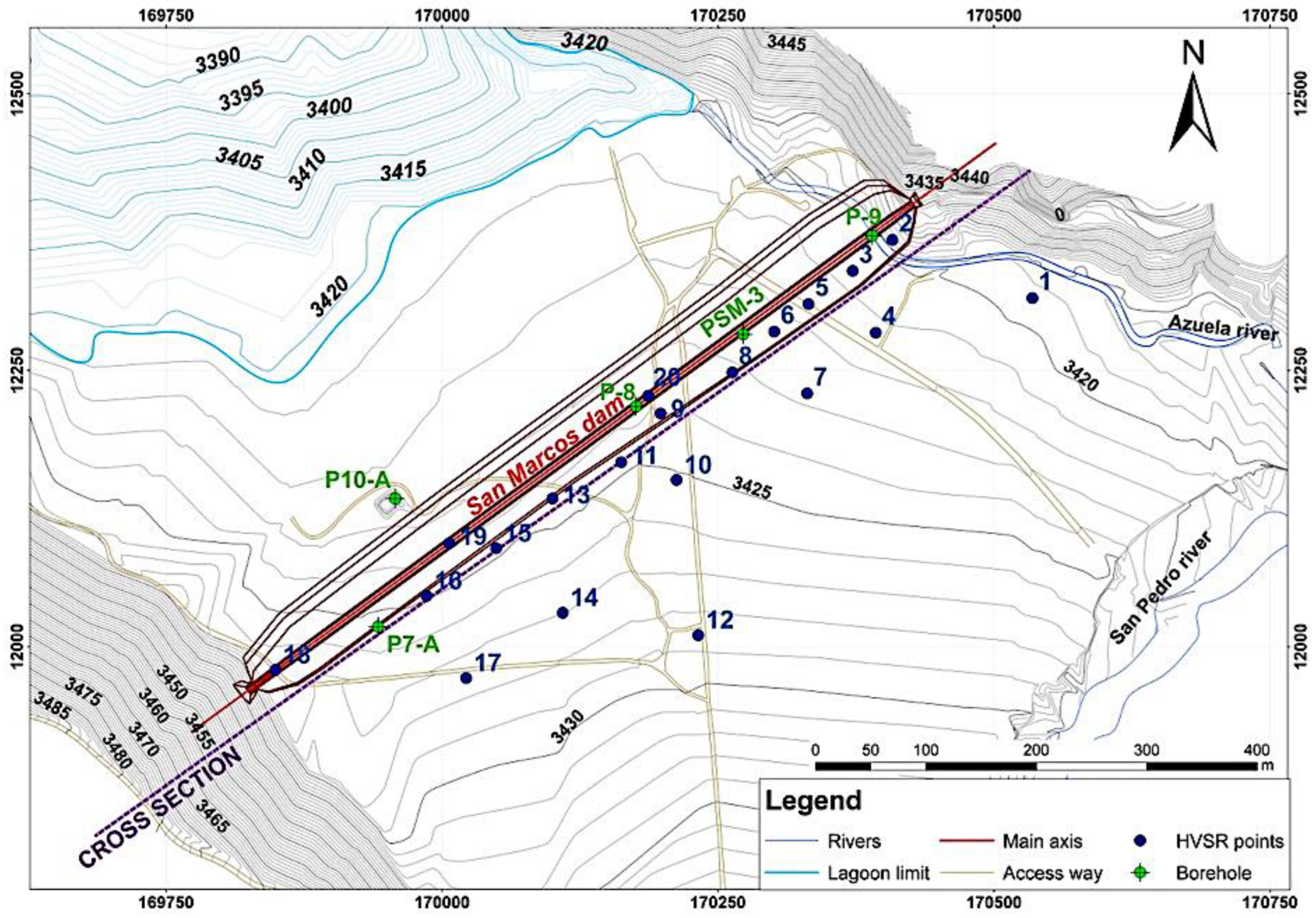
The geophysical research campaign has consisted of the application of the HVSR technique carried out on a total of 20 single station points, which have been distributed along the base of the dam, its crest, and a parallel alignment separated about 50 at 150 m, as it can be seen on
Figure 4. Three tests, numbered 18, 19, and 20, were carried out on the dam’s crest. While points 1, 12, 14, and 17 were measured in an area further away from the foot of the dam, their results were used due to the continuity in the materials that make up the area.
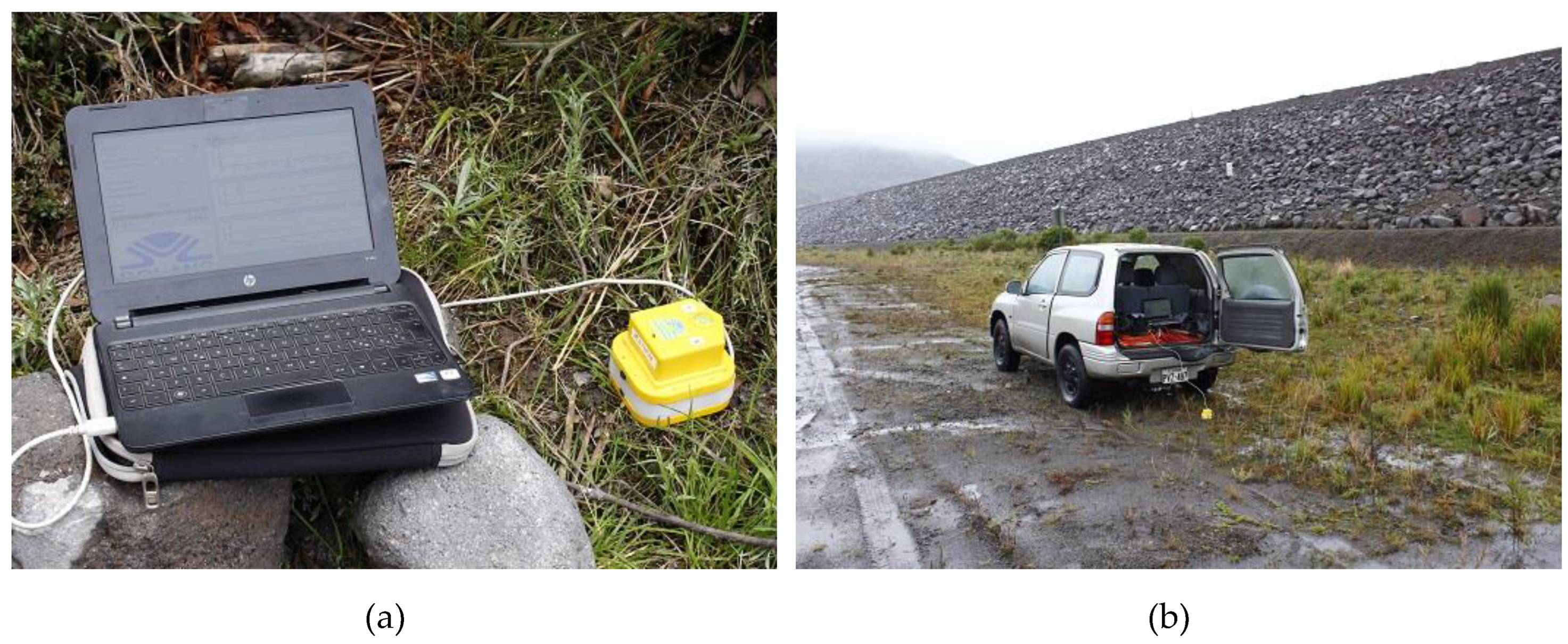
At each point, the equipment for measuring environmental noise or microtremor has been parked, which consists of triaxial equipment composed of 2.0 Hz natural frequency geophones which are arranged according to the three directions of space: N-S, E-W, and vertical Z (
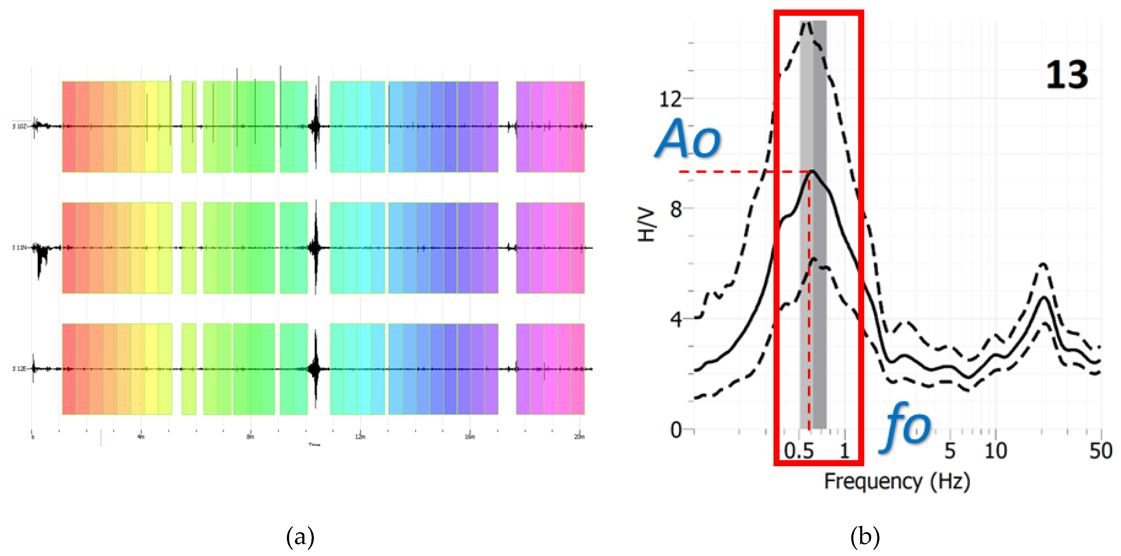
Figure 5a). This measurement unit is connected to a computer that controls the measurement parameters (recording time and measurement frequency) and stores the data (
Figure 5b).
The records measured at each HVSR station point were obtained by meticulously capturing the surrounding vibrations for a total of 20 minutes. This thorough data collection process ensures the reliability of findings [
35].
4. Results
The HVSR technique surveys were processed using the free software program GEOPSY (
www.geopsy.org; [
35,
36]). That consists of analyzing and separating the time windows of the records from the three components obtained in the field (
Figure 6a). The invalid or poor-quality data in the windowing separation are then erased, and a fast Fourier transform will be applied to the valid ones to obtain the frequency distribution curve (
Figure 6b). From these results, that dispersion curve, also called ellipticity, is obtained and relates the spectral ratio (H/V) of the horizontal component to the vertical one, or amplification (
Ao), with the frequency distribution. Thus, for each point tested, a pair of values is obtained, which relates the maximum amplification
Ao with the frequency considered fundamental to the terrain in the area (
fo) that defines the conditions of Nakamura's two-layer model [
35].
Once the field data of the 20 points tested in the surroundings of the San Marcos dam were processed, this pair of values was obtained for each, where the range of the natural frequency of the terrain,
fo, being between 0.12 Hz and 61.26 Hz, while the value of the amplification
Ao is between 0.95 and 9.33 (dimensionless), this being dimensionless (see three first columns in
Table 1).
Table 1 also shows the results obtained for each of these 20 HVSR measurement tests carried out and, consequently, the calculated value of the vulnerability index
Kg (dimensionless) according to Equation (2) and the calculated value of the
GSS (γ) according to Equation (3) shown in fourth and fifth columns. In the study area, the values obtained in the research carried out by Torres [
8] for the area surrounding the location of the San Marcos dam were 501 Gal for a return period of 500 years, a value that will be used in the application of Equation (3). This value includes the PGA acceleration in rock and the potential amplification produced by the thick sedimentary terrain that can happen in the dam's construction area. Following the abovementioned criteria, six measurement points have been identified where the value obtained from the
GSS parameter (γ) is greater than 10
-2, i.e., they have susceptibility to liquefy. These points correspond to the HVSR single station tests: 8, 9, 10, 13, 14, and 20, and it is indicated as YES (
GSS capacity or susceptibility valorization) in the sixth column of
Table 1. At the HVSR 11 and 15 station points, the obtained values are at the limit of susceptibility (included as YES too). That is why it has been considered in this list with said exception (acceptance between parentheses).
The last column of
Table 1 indicates the analysis using only
Kg as an evaluation of susceptibility to liquefy (used by some authors). In that situation, the susceptibility will be classified whether it is exceeded or is less than this limit of 10, considering point number 6 as susceptible because its value is close to 10 and the location is between 5 and 8 HVSR stations that they are susceptible [
12].
Additionally, the
Kg index is represented graphically in
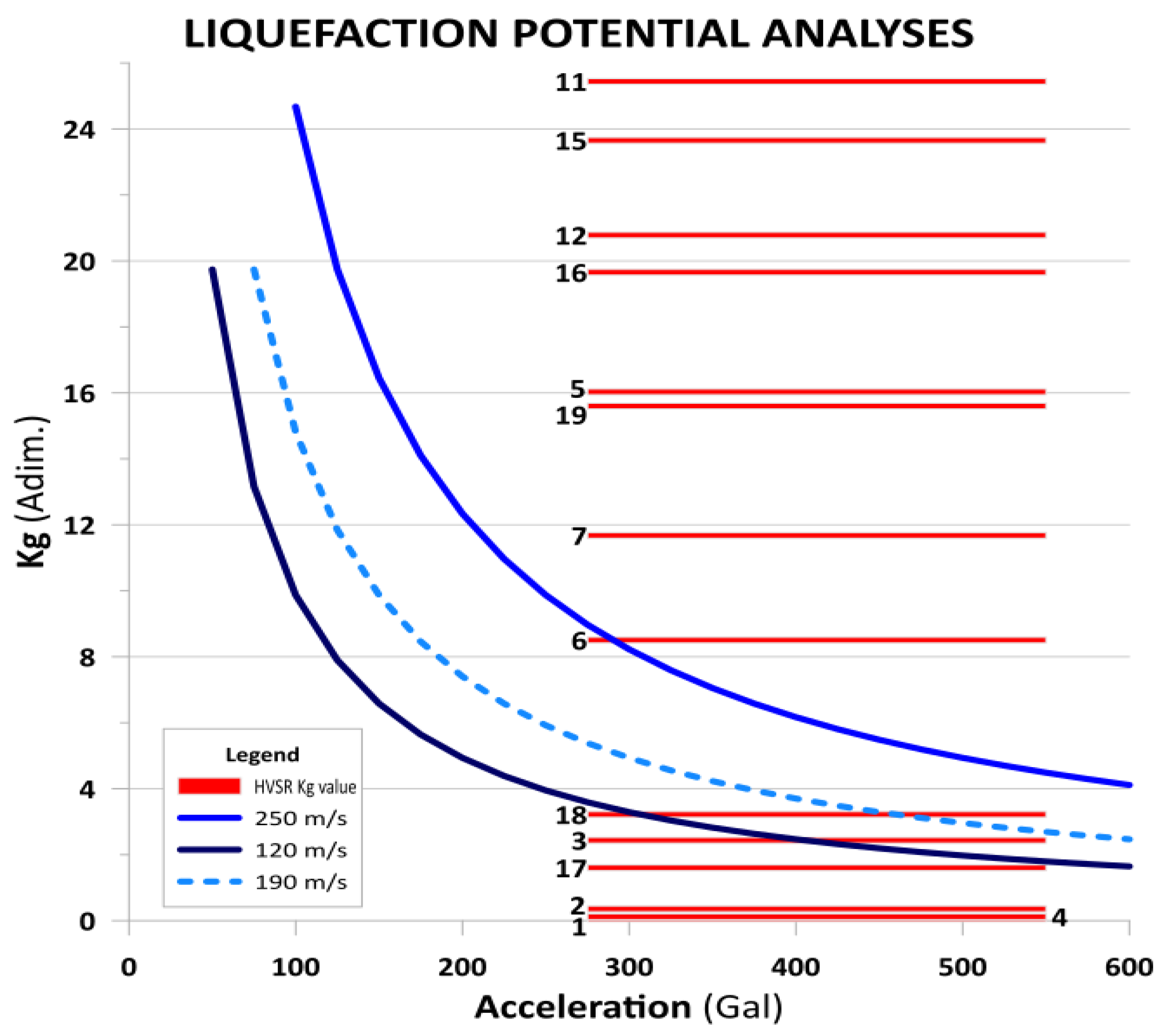
Figure 7, where a new analysis of the values obtained by the HVSR tests is carried out, and Equation (1) and Equation (2) are combined to establish the potential of a liquefaction zone. The
Kg index has been indicated as a bar between the most probable accelerations observed in the study area related to an earthquake. According to Torres [
8], the PGA of the area is established between 275 Gal (minimum obtained for rock also in the NEC-SE-DS [
16] and 550 Gal as the maximum value of acceleration expected in the area considering the amplification of the site effect. Over the same graph, the results relating to the velocities
Vs for sediments in the area (minimum of 120 m/s and maximum of 250 m/s) are displayed, with the average value of 190 m/s represented by a dashed line. These
Vs30 values have been obtained by calculating the
Vs from the SPT tests in the different boreholes where they have available information, according to the formulation for all types of soils and sands shown in Sil and Haloi [
37]. A
Vs30 average of 185 m/s was obtained with extremes of 135 m/s and 215 m/s.
In this graph, the points above or at the limit associated with a
Vs would be or present susceptibility to liquefaction, while those below them are considered stable. Also be considered in
Figure 7 that the points whose calculated
Kg value is greater than 26 have been excluded for better-detailed representation (i.e., points 8, 9, 10, 13, 14, and 20) and since they are clearly above the
Vs value of 250 m/ s. The HVSR points 5, 7, 11, 12, 15, 16, and 19 are located above any
Vs value, which indicates their high susceptibility to suffering liquefaction processes for the accelerations considered and for a value of
Vs average between the indicated ranges.
HVSR points 3, 18, and 6 present values of the
Kg index located between the
Vs limit lines (120 m/s and 250 m/s) for the expected accelerations in the study area. Points 3 and 18 are located at the ends of the dam (see
Figure 3) and would present susceptibility in case of accelerations over 475 Gal and 300 Gal, respectively (for
Vs values over 120 m/s). In the case of the 6 HVSR point, it would be susceptible to liquefying for accelerations under 285 Gal at
Vs values of 250 m/s. On the other hand, points 1, 2, 3, 4, and 17 are clearly below any
Vs curve value considered, so they would be in stable zones (see
Figure 7 and
Table 1 for references).
Both susceptibilities (from
Table 1) were combined with the above results obtained and analyzed. In that case, it is observed that points 8, 9, 10, 11, 13, 14, and 20 coincide in both analyses, which indicates a high liquefaction potential for those areas. Points 3, 5, 6, and 18 could be ruled out if liquefaction occurred (given by some small
GSS values), and the same for points 15, 16, and 19.
Figure 8 presents a representation map and identification of the susceptible-to-liquefaction points indicated above through a red circle. They are around or adjacent to the position of the P-8A borehole, located in the central area of the dam. This survey is where the greatest thickness of superficial granular sediments has been investigated, related to finer fills that could correspond to drainage paleochannels of the ancient San Marcos lagoon [
9].
So, the P-8A borehole will be used as the reference in the analysis to compare the results of the liquefaction factor SFliq through the analysis of SPT tests with those obtained in this geophysical processing.
Table 2 presents, in the fourth first column, a summary of the logging of the P-8A survey based on the SUCS soil classification tests (obtained from the samples extracted in the SPT tests). The impact values are not available below the depth of 30.0 m (it is assumed that rejection has been obtained in the impact when pyroclastic materials from the Cayambe Volcanic Fm. are found; see
Figure 2). Drilling begins at meter 1.5 because the upper meter comprises peat-type materials and paramo lacustrine sediments with zero resistance to the dynamic penetration test.
According to the logging, the superficial layers correspond to the SM SUCS-typology (sands), which would be fine sands with a pumice-granulated composition, according to the description of the soil nucleus [
7]. That gives way to a 19.0 m section composed of poorly graded fine sands (SP-SM), which present intercalations of a section of SM fine sands at the 12.0 m depth. From 22.0 m onwards, the presence of silty areas with gravel is identified in the drilling (possibly related to the deposition of lahars or pyroclastic flows removed and reworked in the aqueous phase, exceeding values of 20 in N
SPT tests the aqueous phase from this depth onwards).
Regarding SPT blows up to 7.0 meters, values lower than ten are detected, increasing this number of blows between 8.0 m and 22.0 m to an average value of around 13 (with extremes in the range of 11 to 17). Finally, note that in the said survey, the water table detected was established at a depth of 2.0 m below the starting level (within the less compact and peaty type materials), which is a value to be considered very superficial.
Following the methodology indicated in Youd and Idriss [
2] using Equation (4), the results of the calculated data for safety factors are shown in the fifth to seventh columns of
Table 2. These calculations have been computed to establish an average site acceleration of 0.331
g and a maximum earthquake expected at the zone
Mw = 5.0 (source-to-site epicenter distance of 38 km), according to probabilistic seismicity analyses PSHA performed by Torres [
8] and indicated in the norms [
16].
From those calculations it can be seen that the tested materials present shallow from 6.0 m a safety factor value lower than 1.0 with a contractive behavior (at 5.0 m the obtained value is close to 1 and it is included). Moreover, the
SFliq (seventh column of
Table 2) for that 6 m thickness is close to unity (0.85 on average). The last column of
Table 2 indicates the characteristics of the materials in terms of their behavior (contractive or dilative). However, this determination would require complementary information for accuracy, such as the proportion of fines in the sample, which is not currently available.
The values shown in
Table 2 consider some average conditions, such as those expressed in MIDUVI’s (2015) norm and from PSHA analysis. However,
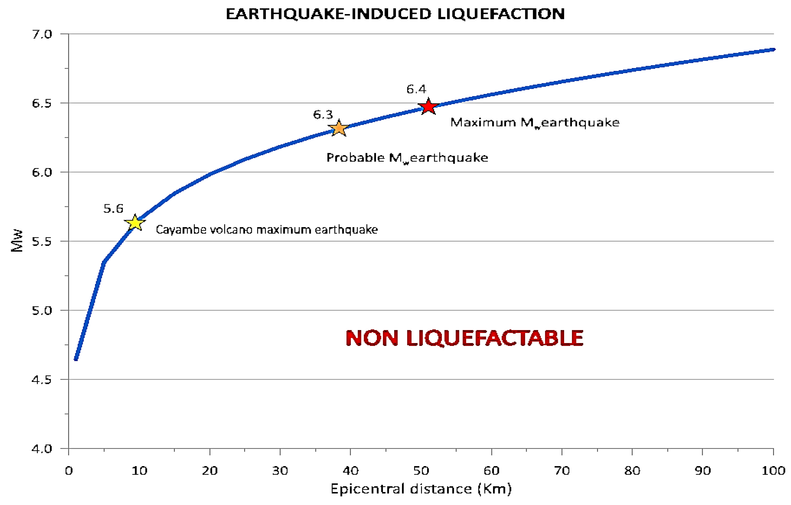
Figure 9 shows that the Mw can be exceeded, even for Cayambe volcano earthquakes (produced at the “San Marcos-type” eruption scenario) with a probable Mw 6.3 earthquake 38 km epicenter location away from the San Marcos dam area. Also, it must be considered that the amplification due to the thick sediment stratigraphy in around the dam area can reach the ground acceleration to an extreme value of 0.51
g [
8].
Considering those maximum seismic risk values and for the same conditions and the same drilling (P-8A) located at the center of the dam and the valley, where the maximum sediment thickness was developed (see
Figure 2), they were performed calculations for the variation of the liquefaction safety factor from different
Mw earthquake scenarios, starting from the magnitude
Mw 3.5, as the reference under which it is considered that liquefaction phenomena cannot be produced, through the
Mw 6.0, a value that exceeds those
Mw earthquakes from the nearest source, the Cayambe volcano (
Table 3).
Thus, using Youd and Idrisss Equation (4) [
2] relation, said
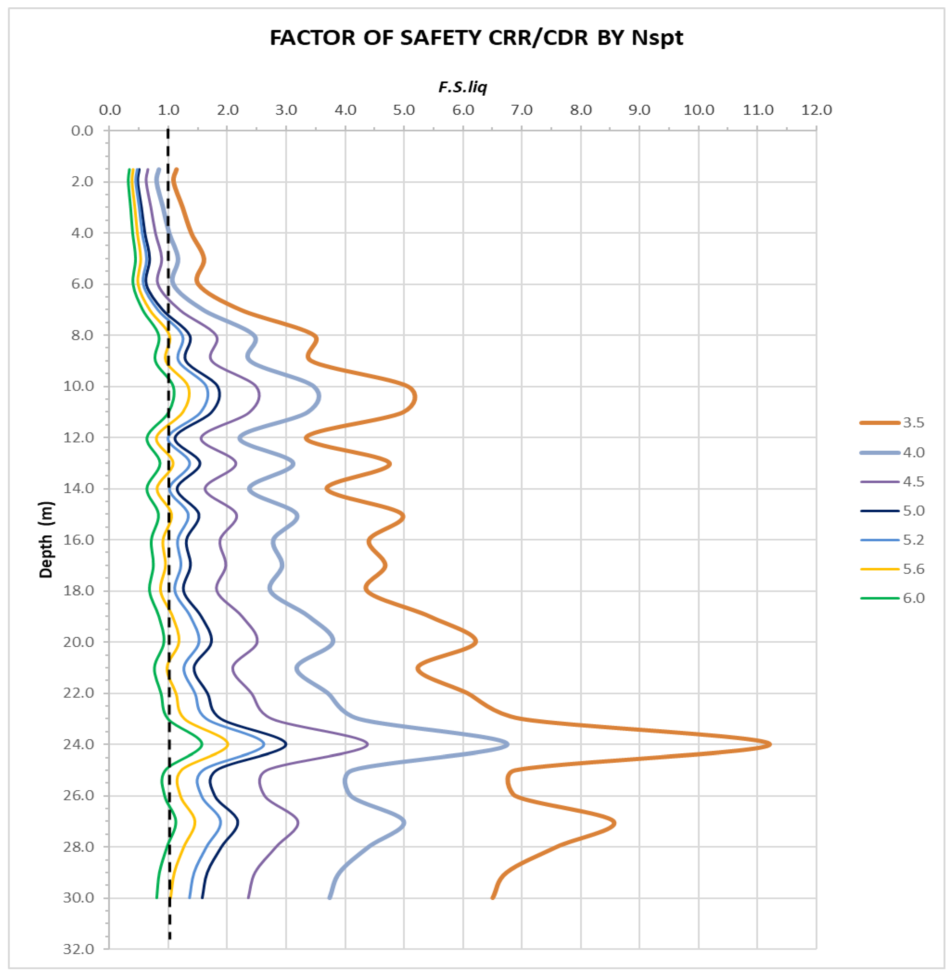
SFliq values presented in
Table 3 were graphically represented in
Figure 10 for seven different values of earthquake intensity: 3.5, 4.0, 4.5, 5.0, 5.2, 5.6, and 6.0 (it must be taken into account that the scale of the moment is logarithmic, not linear). The extreme values chosen are those that are considered limits: on the one hand, earthquakes lower than 3.5
Mw do not usually produce or induce liquefaction processes [
2], while the earthquake of
Mw 6.0 is close to the maximum value expected in the area, according to Torres [
8] (see
Figure 9).
It can be seen that when the
Mw is strictly under the 4.0 seismic forces cannot produce any liquefaction process; analyzing the obtained results (
Table 3). For the
Mw 4.0 value, the first 3 m of sediments could have the probability to liquefy. That depth is increasing, and also the
SFliq is decreasing for 4.5 (6 m), 5.0 (7 m), and 5.2 (7 m)
Mw earthquake moments. At the 5.6
Mw value, the first 9.0 m sediments have safety values under 1.0 and the first 7.0 m under 0.65. Moreover, if the 6.0 Mw is considered, all the 30 m of sediments have the potential of liquefy.
From values lower than 5.6 at the moment magnitude (
Mw), the affected depth with liquefaction capacity rises to 7.0 m, even for an earthquake value in the order of moment magnitude 4.5
Mw. That, together with the saturation (a water table that could reach the surface in rainy times), the high permeability values of these materials (established at 10
-4 m/s according to field tests up to 30.0 m depth in that area), and the low compactness of the first sedimentary levels (which is reflected in the P wave velocity values obtained, which are 430 m/s up to 10.4 m and 860 m/s up to 18.3 m depth from the surface) gives a high probability of a liquefaction phenomenon occurring in the first 7.0 m of sediment thickness [
7].
5. Discussion
Measuring microtremors or ambient noise using the HVSR seismic technique is an easy, quick and inexpensive way to define the terrain’s fundamental frequency [
39,
40,
41]. It is based on the existence of a two-layer geological model: sedimentary material (such as soil or recent sediments) found over a rocky basement or a compact one [
11,
39]. This technique is widely validated for this purpose by various authors [
39,
40,
41,
42,
43,
44,
45], among others. One of the strengths of that seismic survey is its repeatability and the robustness of the measurements, which is an excellent support for its use [
11,
39,
40,
41].
The analysis of liquefaction using this technique is also supported by authors, including a variety of research places [
46,
47,
48,
49,
50,
51,
52,
53], where they provide the application of the technique endorsed by data from recent earthquakes and its liquefaction effect in different environments. Using the
Kg index or the
GSS value, they considered that this technique could be applicable as a reliable tool for delimiting areas with potential susceptibility to liquefaction. Most of the works related to this type of investigations only use the HVSR surveys results without comparison with other analysis techniques further than assume the Nakamura’s vulnerability index
Kg is valid [
11].
A comparison between the three most used tests applied to assessing liquefaction resistance is summarized in
Table 4. Seismic measures have important advantages such as easy and quick application, repeatability (high in HVSR case, [
39]), and the ability to analyze all types of materials in situ (from a bulk and no disturbed way). On the other hand, the first disadvantage is a small strain analyzed, and the second is the thin layers and the undefinition of materials (no samples can be obtained).
As Andrus and Stokoe and other authors developed, using
Vs as a field index is soundly based because the
CRR and
Vs are similar criteria, but not in proportion. Both are related to void ratio, effective confining stresses, stress history, and geologic age [
45,
46,
47,
48,
49,
50,
51,
52,
53,
54,
55,
56,
57,
58].
However, in cases of difficult access, the adaptability of seismic surveys, such as HVSR, to complement the preferred practice (drill boreholes or conduct in situ tests) delineating the liquefiable strata or applied alone could be successful. Even in the presence of graveled materials, alternation or presence of gravel strata, intercalation of cemented soils, or even the phreatic level seismic surveys can provide a good solution.
Surface processes of liquefaction are triggered by the occurrence of earthquakes whose magnitude exceeds
Mw ~ 4.0 to 4.5 (not only the magnitude but frequency and duration are characteristics that are related to the triggering of those processes). That is widely known and has been experimented, and it could be considered that an
Mw = 5.0 could be a suitable limit for defining an earthquake as a trigger. However, earth levees or dams could be more sensible and could be affected by the abovementioned values [
59].
Between the end of 2016 and the first months of 2017, the Cayambe volcano experienced an anomalous seismic activity. This was characterized by an increase in volcano-tectonic type earthquakes (from internal fractures) and long period type earthquakes (from fluid movement) located between 2 and 8 km below the summit. These seismic events were more intense than the 1995 episode [
15], reaching a magnitude close but under
Mw 4.0 (see
Figure 11A). All this activity was related to the Chingual fault system and the volcano activity to the northern area of the volcano building, i.e., the area where the San Marcos dam was located (see
Figure 11B). This type of scenario, although the lowest in intensity (S0 to S1) considered by the IG-EPN monitorization team, was close to the S3 “San Marcos-type” which produced the natural San Marcos dam and then the lagoon [
8,
15]. The potential impact of this seismic activity on the surrounding area could be significant, and that research is crucial in understanding this impact.
Thus, it must be considered that in the possibility of reaching an event of the S3 scenario, the seismic activity and its associated earthquakes could potentially reach magnitudes between
Mw 4.0 and 5.0 or even exceed this range. From the previous analysis, the low limit of earthquake magnitude was established under 4.0, and 4.5 is a magnitude that can trigger liquefaction processes (see
Table 3 and
Figure 10). The actual activity (from the end of 2017) has returned to a low, but it is still working.
Reviewing the literature, the larger the
Kg index values, the greater the susceptibility of materials to liquefy, but from a qualitative point of view. One of the points is the regional aspect of the HVSR results, both
fo and
Ao and so, the
Kg results [
24,
41]. Some authors select different limit values for liquefaction processes starting that differ from 10 as the limit value indicated by Nakamura [
28]:
Kg >1.7 [
60],
Kg >3.5 [
21],
Kg >5 [
33], or
Kg >20 [
30]. The established value in this research,
Kg >8, is a locally valid value for that area supported by the analyzed SPT essays. Also, Singh et al. [
61] indicate that this is evident when an increase in amplitudes (
Ao) at low fundamental frequencies (
fo), being where the
Kg exceeds 20, the liquefaction processes and its effects are up to 30% from others under that value. Thus, that index could be a vulnerability delimitation parameter for determining weak areas with potential susceptibility to liquefy [
29,
62].
6. Conclusions
The foundation area of the San Marcos dam has been tested for the liquefaction potential using the HVSR technique at 20 single station points. It was obtained the natural vibration frequency fo and its associated value of the H/V spectral ratio (Ao) with a range of values between 0.12 Hz and 61.26 Hz (for fo) and from 0.95 to 9.33 for Ao (dimensionless).
Based on those HVSR parameters from data processing, the
Kg (dimensionless) value was calculated for each of the points according to Nakamura’s formulation [
11], and the shear stress value (
GSS) was calculated for a site acceleration of 0.331
g and an
Mw 5.0 earthquake moment (from PSHA analysis and [
8,
16] conditions). The results determined that the area around the P-8A borehole drilling, in the central area of the dam and the valley, has a high susceptibility to liquefaction based on microtremor measurements,
GSS, and
Kg values.
A comprehensive analysis of the liquefaction susceptibility factor (
SFliq) has been conducted for this area. The analysis was based on the impact of the SPT tests (Youd and Idriss, [
2] procedure) for local or site effect conditions, with an acceleration of 0.51
g (501 Gal) and earthquake design moments from
Mw =3.5 to a maximum of
Mw = 6.0. Under these conditions, the entire P-8A analyzed survey (30 m) column for the maximum earthquake moment showed a liquefaction safety factor value of less than one, indicating a potential risk. No liquefaction potential was observed for strictly earthquake moments less than 4.0, further validating our thorough analysis.
The SFliq variation for earthquake Mw moments from 4.0 to 5.6 (expected value as maximum from volcano activity) was observed under 1.0 for the first 7.5 m of sedimentary surface materials, so the value of said factor indicated the potentiality of liquefy processes can appear. Taking into account the results, the high level of the water table position (2.0 m depth), the high permeability values of the surface materials, as well as their low compactness (from seismic P-wave velocity), it can be concluded that the central area of the San Marcos lagoon dam has characteristics of high probability of suffering liquefaction under earthquake conditions with moment magnitude over the 4.0 Mw.
Microtremor measurements through HVSR tests can be considered a powerful technique in the definition of liquefaction susceptible areas using the pair of values obtained from the process and the calculation of the vulnerability index (fo, Ao, and Kg index). This technique is quick, easy to apply and processing, robust and repeatable, and low-cost. It is a powerful tool in identifying liquefaction susceptible areas, especially when combined with direct surveys and laboratory essays.
However, that tool is a qualitative approximation because it does not have the ability to define a quantitative valuation layer-per-layer, depth of affected materials, or the identification of thin layers, adding the determination of the earthquake moment at the processes could start. Also, it is highly recommended that a dense mesh of measures be applied to get accuracy, especially in places with lateral variations in facies or materials (complex geology).
HVSR is a valid and robust test for liquefaction analysis, with its respective limitations being the Kg vulnerability index, which is a proxy to define potential areas or previous analyses of risk to liquefaction. It can provide a quick and effective indication of areas with probability or susceptibility to this phenomenon.
