Preprint
Article

Sharks and Rays of Northern Australia’s Roper River, with a Range Extension for the Threatened Speartooth Shark Glyphis glyphis

Altmetrics

Downloads

105

Views

43

Comments

0

A peer-reviewed article of this preprint also exists.

Submitted:

03 October 2024

Posted:

04 October 2024

You are already at the latest version

Alerts
Abstract
Northern Australia is considered a ‘lifeboat’ region for globally threatened sharks and rays (elasmobranchs), although much of the region is understudied. The Roper River in the Northern Territory’s Gulf of Carpentaria has been inadequately surveyed, with most elasmobranch data gained opportunistically through freshwater fish surveys. This study aimed to determine the occurrence of elasmobranch species in the Roper River through targeted field surveys conducted between 2016 and 2023 and a review of data from other sources. Four euryhaline species were recorded comprising two sharks, a sawfish, and a stingray. Records of the globally Vulnerable Speartooth Shark (Glyphis glyphis) represented a significant range extension and the documentation of a new breeding population. Records of the Critically Endangered Largetooth Sawfish (Pristis pristis) extended almost 400 km upstream, highlighting extensive use of the river system. A predominantly marine species, the Critically Endangered Giant Guitarfish (Glaucostegus typus) was observed in brackish estuarine waters, approximately 15 km upstream from the river mouth. Further research is required to develop a more thorough understanding of abundance, life history, and population connectivity for these species in this river system. Given the documentation of threatened species, the potential impacts of fisheries, water allocations, and climate change requires assessment.
Keywords: 
Subject: Biology and Life Sciences  -   Ecology, Evolution, Behavior and Systematics

1. Introduction

Understanding the distributions of animals in space and over time has become increasingly important to evaluate ecological processes, how species may respond to anthropogenic threats including climate change, and to measure the impact of conservation efforts [1]. Knowledge gaps in geographic ranges and the environmental drivers of distributions of aquatic species has limited the implementation of appropriate ecosystem-based management [2]. Understanding the distribution of species throughout their various life stages and across habitats is essential for effective conservation planning and protection of habitats [3,4]. Area-based management is widely being implemented to protect biodiversity in terrestrial, freshwater, and marine environments, with significant commitments to implementing protected areas from the international community [5]. Area-based management is also increasingly being utilised to maximise conservation outcomes for elasmobranchs (sharks and rays), and can incorporate biological, behavioural, and ecological characteristics of species [4].
The conservation of elasmobranchs is a global priority. One third of all species (33.3%; 397 species) are at risk of extinction, and a further 13.7% (163 species) are categorised as Data Deficient [6]. Elasmobranch species which utilise non-marine environments such as estuaries and rivers during critical stages of their life histories are particularly at risk of extinction. These animals have an elevated risk of exposure to anthropogenic pressures such as overfishing, habitat loss and degradation, and pollution [7,8]. Euryhaline generalist (hereafter, ‘euryhaline’) elasmobranchs are a group of ten unique species which are physiologically capable of occurring throughout salinity gradients ranging from marine (~35 ppt) to freshwater (<5 ppt). These species generally use freshwater and/or estuarine environments for particular life stages (e.g., nursery areas) [8]. Significant gaps in knowledge exist for euryhaline elasmobranchs, with most species lacking key life history, movement ecology, and habitat use data [9].
Northern Australia is considered a ‘lifeboat’ region for globally threatened elasmobranchs due primarily to its low human population density [10,11,12]. The region is home to half (five species) of the world’s known euryhaline elasmobranchs [8], four of which are threatened globally [6]. The region still has vast swathes of uninhabited land, intact wetlands, and free-flowing river systems, as well as Marine Protected Areas (MPAs) and areas closed to commercial fishing e.g., [13,14,15,16]. Due to its remoteness, limited access to many areas, and the costs and logistics associated with research, northern Australian waters have been relatively little studied, with many areas lacking any dedicated elasmobranch surveys. Euryhaline elasmobranchs in particular were, until recently, often only recorded opportunistically during freshwater fish surveys e.g., [17,18,19]. Northern Australia is under increasing development pressure, and the extraction of groundwater or the ‘harvesting’ of surface water during wet season flow events is increasingly being utilised for irrigation and resource extraction [20].
Although distributional data for euryhaline elasmobranchs in remote regions of Australia has improved significantly over the last two decades e.g., [21,22,23,24], many areas have yet to be surveyed. One such example of limited survey effort is the Roper River of Australia’s Northern Territory (NT). This river has had one targeted elasmobranch survey, with sampling effort focused on freshwater upstream environments, with only two downstream sampling sites close to the river mouth [25]. Given the lack of data on distribution, biology, and habitat requirements of elasmobranchs in many remote river systems [9], this study aims to determine the occurrence of elasmobranchs in the Roper River through species-specific targeted surveys and a review of literature and other data sources.

2. Materials and Methods

2.1. Study Site

The Roper River is a large river system in the south-west Gulf of Carpentaria in the wet-dry tropics of the Northern Territory, Australia (Figure 1). Its catchment of almost 80,000 km2 makes it one of the largest systems in northern Australia [26,27]. Water flow is seasonally variable, with most (>90%) occurring during the monsoonal rainfall of the wet season (roughly, November-April) [20,26]. The Roper River is however, a permanently flowing (perennial) tropical river, fed in the dry season by groundwater discharge driving flow for over 200 km upstream of the tidal limit [20,27]. The lower Roper River is tidal, with tidal influence reaching Roper Bar (150 km inland) [26]. The lower 100 km of the river is vegetated with mangroves, while freshwater riparian plant species such as Melaleuca spp., Eucalyptus camaldulensis, and Casuarina cunninghamiana occur upstream from around 67 km from the mouth [28].
The human population in the Roper River catchment is very small at approximately 2,500 people [27]. The predominant land use is cattle grazing, occupying 46% of catchment land [26,27]. Aboriginal freehold tenure accounts for 45% of the catchment, with the entire area to the north of the Roper River making up the South-East Arnhem Land Indigenous Protected Area [27,29]. National parks account for 6% of catchment land, followed by irrigated horticulture (0.02%) and mining (<0.01%) [26,27]. Recreational and subsistence fishing occurs throughout the Roper River, with commercial fishing concentrated at the mouth of Port Roper and surrounding coastal waters [30]. The Roper River was closed to commercial net fishing in 1991 due to the potential impact on recreational fishing and tourism [26]. The river is popular among recreational fishers, with most effort primarily occurring in the upstream stretches near Munbililla (Tomato Island) and the mouth and coastal waters.

2.2. Elasmobranch Surveys

Targeted threatened elasmobranch surveys were conducted in October-November 2016 (3 days) and October 2017 (4 days) for Largetooth Sawfish Pristis pristis, and September 2023 (5 days) and November 2023 (7 days) for Speartooth Shark Glyphis glyphis. Surveys were conducted from the mouth of the Roper River to just upstream of Roper Bar crossing, and some tributaries, including the Baghetti (Wilton) and Phelp Rivers, and Wungguliyanga and Painnyilatya Creeks. Survey site selection was based on habitat suitability for the target species with freshwater reaches and pools targeted for P. pristis and turbid brackish tidal reaches for G. glyphis.
All survey sites were tidally influenced to varying degrees, although this was minimal in upstream reaches. Sampling was conducted using 6-inch monofilament gillnets (29 m or 58 m length), and baited hook-and-line (rod or hand line). Hooks were circle (size 5/0 to 9/0) and bait consisted of fresh caught bony fishes local to the area (e.g., Bony Bream Nematalosa erebi, Barramundi Lates calcarifer, Popeye Mullet Rhinomugil nasutus).
Each captured elasmobranch was measured (total length [TL] for sharks and sawfish; disc width [DW] for stingrays), sexed, assessed for maturity, sampled for future genetic analysis, photographed, and tagged with a PIT tag to assess recaptures. Freshwater Whiprays (Urogymnus dalyensis) were weighed using a vinyl sling and hanging scales rated to 100 kg. Life stage and maturity was assessed based on the presence/absence of an umbilical scar, whether the umbilical scar was open or closed, calcification of claspers for males, and by observation of pregnancy for females (i.e., clearly distended abdomen). Neonates are defined as animals less than approximately one month old with visible open or closed umbilical scars [31]. Juveniles were defined as individuals older than one month (with no visible umbilical scar) but not yet approaching maturity. Subadults were defined as individuals approaching maturity, with subadult males having partially calcified claspers. The maturity of females could not be assessed externally (aside from mature pregnant females), therefore size classes of males and predicted sizes-at-maturity were used to estimate female maturity. All animals were released after processing at the site of capture.
Environmental variables (water temperature, water depth, salinity [in Practical Salinity Scale; PSS], and turbidity [in New Turbidity Units; NTU]) were recorded at each survey site.
Differences in size between males and females was tested with two-sample T-tests with significance set at p<0.05. Catch-per-unit-effort (CPUE) was calculated as the number of individuals caught per hook per hour for baited hook-and-line fishing, and as the number of individuals caught per 100 m net length per hour for gillnet fishing. CPUE was calculated for target species only (G. glyphis and P. pristis).

2.3. Literature and Data Review

Literature and data sources were reviewed for additional records of elasmobranchs in the Roper River. To ensure records were primarily of euryhaline elasmobranchs, records were collected from the estuary (approximately 6 km downstream of the Port Roper public boat ramp; Figure 2) to the upstream extent of the river and its tributaries, and excluded marine waters. The review used the following approach: (1) the terms ‘Roper River’ AND ‘shark’, ‘ray’, or ‘sawfish’ were searched on Google Scholar; (2) the online spatial databases Atlas of Living Australia [32] and iNaturalist [33] were searched for each northern Australian euryhaline elasmobranch (Bull Shark Carcharhinus leucas, Northern River Shark Glyphis garricki, G. glyphis, P. pristis, U. dalyensis); and (3) public records were sourced from data contributed to the Northern Territory Fisheries sawfish database [NT Department of Industry, Tourism and Trade, unpubl. data, 2024]. These records were supplied by recreational fishers and other members of the public.

3. Results

Across the 2016, 2017, and 2023 targeted surveys, 90 individual elasmobranchs were captured via gillnet or baited hook-and-line (handline or rod) over four surveys. Gillnets were deployed for 240 x 100 m net hours and caught 28 elasmobranchs. Sixty-two animals were captured over 354.8 hook hours. No animals were recaptured. Elasmobranchs comprised four euryhaline species from three families: Carcharhinus leucas (Carcharhinidae, n = 36), Glyphis glyphis (Carcharhinidae, n = 40), Pristis pristis (Pristidae, n = 1), and Urogymnus dalyensis (Dasyatidae, n = 13). Additional observations were made of one marine species, Glaucostegus typus (Glaucostegidae, n = 2). Elasmobranchs were captured at depths of 0.8–9.5 m, water temperatures of 27.0–31.4°C, turbidity of 3.2–439.0 NTU, and in fresh (salinity 0.06 PSS) to brackish water (23.6 PSS). The literature and data review produced further records of C. leucas, P. pristis, and U. dalyensis, but did not produce records of G. garricki or G. glyphis (Table 1).

3.1. Carcharhinus leucas

Thirty-six neonate and immature C. leucas were captured from 2016–2023 (gillnet, n = 27; hook-and-line, n = 9). Sharks ranged in size 68.0–139.5 cm TL, with an average of 85.0 ± 21.2 cm TL. The sex ratio was 1:1 (F:M), and there was no significant difference between the size of males and females (two sample T-test, p = 0.46). Twenty-six neonates were captured during October and November 2016 at 68.0–86.0 cm TL. Carcharhinus leucas were captured in very shallow (0.8–4.9 m depth) fresh water (0.06–1.3 PSS) with low turbidity (3.2–44.0 NTU) and water temperatures of 27.9–31.4°C.
The literature and data review produced an additional fourteen C. leucas caught in freshwater by gillnet, hook-and-line, or long-line, or observed swimming, although sizes were not reported for these [18,25,32]. Individuals caught in 2002 were in salinity 0.3–0.7 ppt, Secchi depth (turbidity) 80–130 cm, depths of 3.5–21.0 m, and water temperatures of 23.1–24.3°C [25].
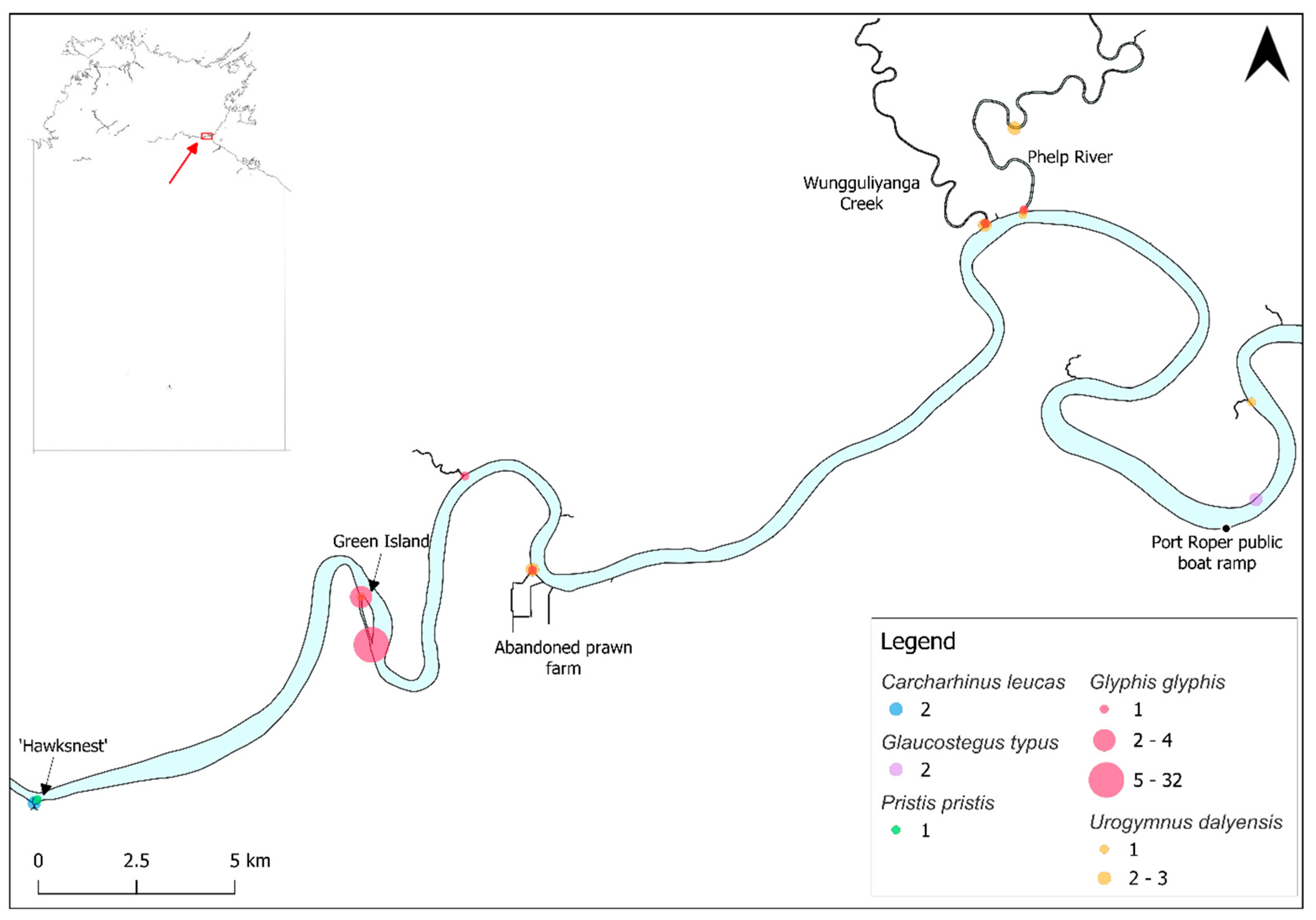
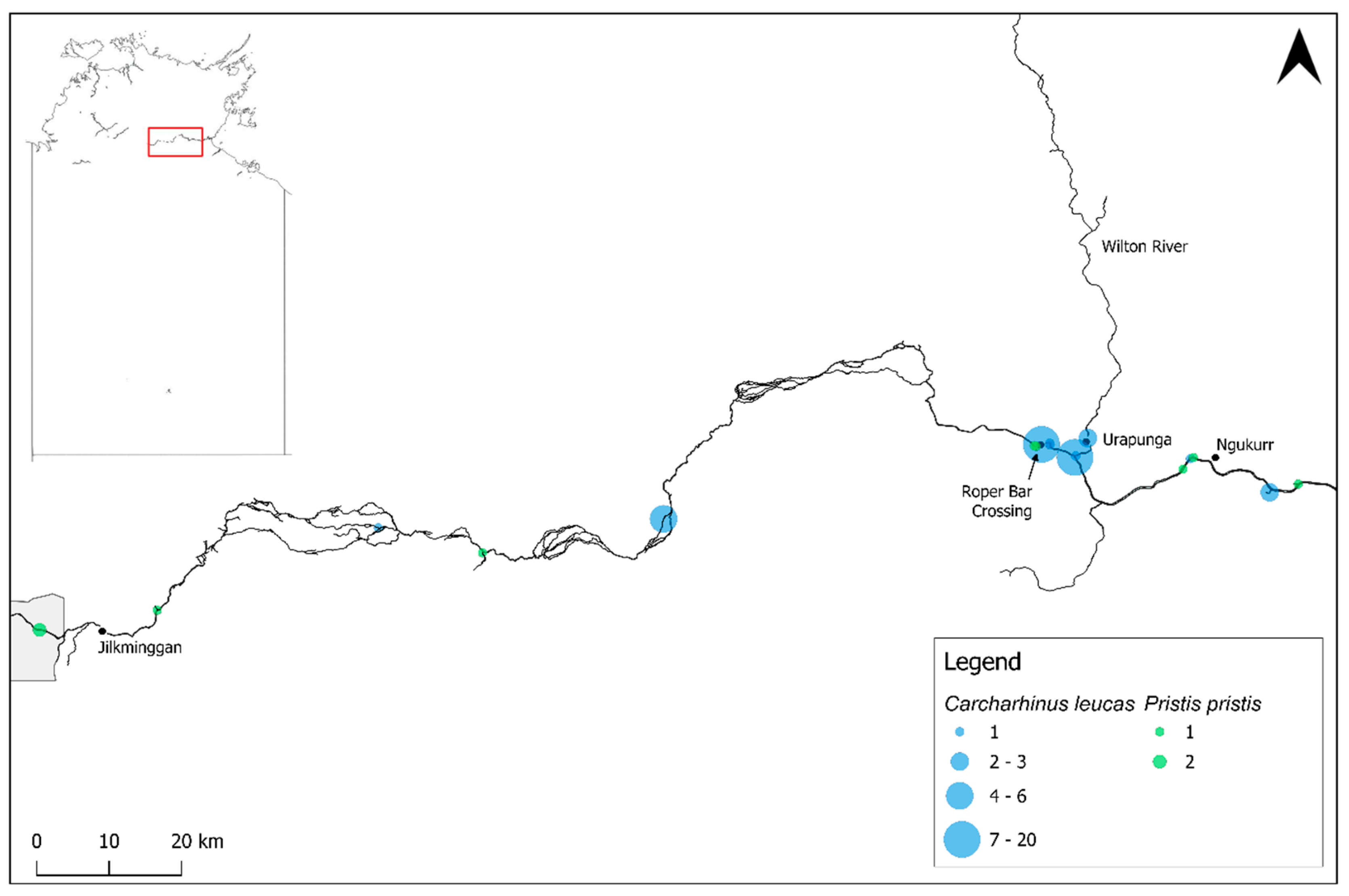
The furthest downstream capture location for Carcharhinus leucas was approximately 80 km upstream from the mouth at the ‘Hawksnest’ (Figure 2) [this study], a small rocky island where the Roper River substrate becomes rockier, significantly less muddy and turbid, and water is completely fresh (~1 PSS) compared with the estuarine stretches. Carcharhinus leucas also extends much further upstream into entirely fresh, clear water with substrates of rock, sand, and silt this study and [25], with records to ~300 km upstream (Figure 3).

3.2. Glaucostegus typus

Two G. typus visually estimated at ~100 cm TL were observed in November 2023 approximately 15 km upstream from the Roper River mouth (Figure 2). These were observed in <1 m depth, water temperature of 30.5°C, turbidity of 19 NTU, and salinity of 29.38 PSS. This species matures at 150–180 cm TL [34], indicating that these individuals were likely immature.

3.3. Glyphis glyphis

Forty neonate and immature G. glyphis were captured in the lower Roper River by hook-and-line over 314.3 hook hours in 2023. Sharks ranged in size from 53.5–125.0 cm TL, with an average of 83.3 ± 20.6 cm TL. The sex ratio was 1:1.22 (F:M) and there was no significant difference between the size of males and females (T-test, p = 0.68). Nine neonates were captured in November 2023 at 53.5–62.0 cm TL, while only larger juveniles were encountered in September. Catches occurred in a range of salinities, from 5.8 to 20.8 PSS, and in turbidity of 15.0–439.0 NTU. Water depths ranged from 1.2–9.5 m and temperatures from 27.3–31.3°C. CPUE was 0.13 individuals per hook hour.
Glyphis glyphis captures were restricted to a narrow estuarine stretch of the Roper River, with records from the Phelp River confluence upstream to the northern end of Green Island, approximately 66 km from the river mouth (Figure 2). This section of the river has a substrate consisting primarily of mud and sand resulting in higher turbidity. Salinity ranged from ~5.8–30.0 PSS during targeted surveys.

3.4. Pristis pristis

One immature male P. pristis was captured by gillnet in October 2017, at 2.4 m depth. This individual was 103.3 cm TL. No water quality data was recorded. CPUE was 0.004 individuals per 100 m net-hour.
The literature and data review produced a further ten P. pristis records which were observed or captured by baited hook-and-line, gillnet, or electrofished, or observed swimming by members of the public or other researchers in the Roper River and its tributaries during 2002–2024, ranging in size ~100.0–340.0 cm TL [25,32,35; C. Perna pers. comm., 2023; NT Department of Industry Tourism and Trade, unpubl. data, 2024]. A 103.0 cm TL male P. pristis was captured in May 2024 by Traditional Owners on the Baghetti (Wilton) River at the Baghetti Outstation, approximately 290 km upstream from the Roper River mouth and ~150 km from the Wilton/Roper confluence [S. Miller, pers. comm., 2024]. Pristis pristis were also recorded as ‘common’ in a billabong nearby on the Baghetti (Wilton) River floodplain, where maximum depth was 2 m, and Secchi depth (turbidity) was 10 cm, although specific records are not available [17]. The largest individual (340.0 cm TL) was a female captured at 5.0 m depth, turbidity of 4 NTU, and electrical conductivity of 1244.7 µS/cm which equals <1.0 PSS (salinity) [35].
All P. pristis records occurred in fresh and generally very clear water with rocky/sandy/muddy substrates extending from ~80 km upstream from the Roper River mouth at the ‘Hawksnest’, to Elsey National Park near Mataranka, ~360 km from the mouth (Figure 2 and Figure 3). The largest recorded individual was captured at the furthest upstream site, at 12 Mile Yards Campground in Elsey National Park.

3.5. Urogymnus dalyensis

Thirteen U. dalyensis were captured in 2023 by hook-and-line at depths of 2.0–5.1 m. All individuals were mature or subadult, and four females were observed to be pregnant or possibly pregnant in September, while one had possibly recently pupped (distended abdomen but not firm) in November. Animals ranged in size 83.0–129.5 cm disc width (DW), with an average of 104.5 ± 12.7 cm DW. The sex ratio was 1.6:1 (F:M) and there was no significant difference between the size of males and females (T-test, p = 0.35). Total mass ranged from 16 kg to ~50 kg for the largest individual. Urogymnus dalyensis were captured in depths of 2.8–7.8 m, salinities of 5.8–23.6 PSS, turbidity of 58–292 NTU, and temperatures of 27.0–30.5°C.
The literature and data review produced one additional U. dalyensis record. This individual was caught in July 2002 measuring 124.0 cm DW in the lower Roper River at salinity 26.1 ppt, water temperature of 22.3°C, and Secchi depth of 30 cm [25]. This individual represents the most downstream U. dalyensis record in the Roper River, while the upstream extent of records is the northern end of Green Island, ~66 km from the river mouth (Figure 2). Although not observed during this study, U. dalyensis have also been observed upstream to Jilkminggan (~350 km upstream from the mouth) [Yugul Mangi Rangers pers. obs.].
Table 1. Summary of shark and ray records from the Roper River and its tributaries in the Northern Territory of Australia, excluding coastal waters. Records are from both the targeted surveys and the literature and data review. Size ranges are total length (TL) for all species except for U. dalyensis for which disc width (DW) is reported. Categories are reported for the IUCN Red List of Threatened Species [6] and the Australian Environment Protection and Biodiversity Conservation Act 1999 (‘EPBC Act’) [36]. LC, Least Concern; VU, Vulnerable; CR, Critically Endangered; nl, not listed.
Species IUCN Red List/ EPBC Act Category Number recorded Size range (cm) Depth (m) Salinity (PSS) Turbidity (NTU)
Carcharhinus leucas VU/nl 50 68.0–139.5 0.8–21.0 0.06–1.3 <3.2–44.0
Glaucostegus typus CR/nl 2 100.0 <1.0 29.38 19
Glyphis glyphis VU/CR 40 53.5–125.0 1.2–9.5 5.8–20.8 15.0–439.0
Pristis pristis CR/VU >11 100.0–340.0 <2.0–5.0 <1.0 4
Urogymnus dalyensis LC/nl 14 83.0–129.5 2.8–7.8 5.8–26.1 <58.0–292.0

4. Discussion

The Roper River and its tributaries in the Northern Territory of Australia represent an important system for euryhaline elasmobranchs. Four of the five Australian euryhaline species have been recorded in the river. The Roper River is utilised as a reproductive area for all four species, indicated by the presence of early life-stages and pregnant females. The lower estuarine stretch may also represent an important nursery space for juveniles of marine species, including the Critically Endangered Giant Guitarfish (Glaucostegus typus) [37] which was observed ~15 km upstream of the mouth in brackish water. Elasmobranchs extend almost 400 km upstream throughout the Roper River, as well as almost 300 km into the Baghetti (Wilton) River. Sections of the Roper River’s mid-reaches are heavily braided which is unique in northern Australia and caused by the area’s flat topography and sediment build-up behind choke points [27]. Stream morphology results in several sections of the river being too shallow for elasmobranchs to pass or cut off by dry sections aside from times of flood, limiting some up- and downstream movements to high flow events. The largest P. pristis record was a 340 cm total length (TL) female captured in Elsey National Park [35] which was significantly larger than all other records documented in this study. This species matures at 280–300 cm TL, at which time it generally returns to marine environments [38,39]. This may indicate that this individual had not been able to complete its downstream migration for several years due to a lack of river connectivity.
Sizes of individuals recorded in the Roper River indicate that the system is a reproductive area for all euryhaline species. Sizes of G. glyphis neonates captured during this study fall within the expected size-at-birth range of 50–65 cm TL [22,40]. Neonate C. leucas ranged from 68–86 cm TL, with size-at-birth estimated at 68–78.5 cm TL in the Roper River (based on individuals with open umbilical scars only). Size-at-birth for C. leucas is understood to be 50–80 cm TL e.g., [41,42,43], with likely rapid growth in the first month, as the Roper River individuals larger than 80 cm TL had closed umbilical scars [this study]. Parturition likely occurs prior to the onset of the wet season for C. leucas, G. glyphis, and U. dalyensis, with C. leucas neonates captured in October and November, G. glyphis in November, and pregnant U. dalyensis in September (but not in November). While this is the first insight into reproductive seasonality for U. dalyensis, these results coincide with previously published results for G. glyphis (September–December) [22,44] and C. leucas (wet season in northern Australia) [45]. It should be noted that surveys were limited to the above months and therefore a full picture of seasonality is not available. No neonate or juvenile U. dalyensis were encountered and the habitat preferences of small individuals in the Roper River is unknown. Size-at-maturity for U. dalyensis is estimated at ~90 cm DW for males [34]. Males of this species may mature at a slightly smaller size, with one male assessed as mature during this study at 87.0 cm DW, while a subadult was measured at 83.0 cm DW. No size-at-maturity is known for females [9], however the smallest female captured during this study was observed to be possibly pregnant at 95.0 cm DW. Our results also demonstrate a marginal increase to the maximum known size of U. dalyensis at 129.5 cm DW, exceeding the previously reported 124.0 cm DW (also from the Roper River) [25].
Targeted surveys resulted in a significant range extension for G. glyphis. Forty individuals ranging from neonate to ~3 years old based on the presence of visible umbilical scars and reported length-at-age data [46] were captured in the lower Roper River in 2023. The presence of neonates and juveniles indicates that the river is a reproductive area, as juveniles tend to remain in river systems for at least six years, or possibly until they mature at around 12 years old [24,46; J.M. Constance et al. unpubl. data, 2024). During these surveys, G. glyphis were recorded only from a restricted band of suitable habitat, which extended to ~66 km upstream of the mouth. Prior to this study, G. glyphis had only been considered extant in the Wenlock and Ducie Rivers in the Port Musgrave system on western Cape York, Queensland, throughout the Van Diemen Gulf in the NT, western NT, and into the Kimberley region of Western Australia [22,47]. Preliminary data demonstrates connectivity between the Roper and Wenlock Rivers, based on a mature female which was tagged in the Wenlock River and travelled to the Roper River in the late dry season (September/October; R. Pillans pers. comm., 2024). Further research is required to develop a more thorough understanding of the Roper River population size, structure, and connectivity with the species’ wider range.
Recreational and commercial fishery activities in the Roper River have the potential to impact elasmobranch populations, including threatened species such as G. glyphis and P. pristis. Line fishing makes up 75% of recreational effort in the NT [48]. While many recreational fishers primarily use lures to target Barramundi (Lates calcarifer), baited hook-and-line fishing regularly occurs which results in increased elasmobranch bycatch [48,49]. Recreational fishers sometimes retain rather than release threatened elasmobranchs, and this has been seen with river sharks [50] and P. pristis, with an individual discarded on land at the McArthur River crossing, south of the Roper River [NT Department of Industry, Tourism and Trade, unpubl. data, 2024]. Two commercial fisheries operate in the Roper River and its coastal waters: the NT Barramundi Fishery and the NT Mud Crab Fishery. The NT Barramundi Fishery utilises gillnets from 1 February to 30 September each year [30], resulting in river shark and sawfish bycatch and mortality [51]. The NT Mud Crab Fishery operating in the Roper River may capture neonate G. glyphis while they are still small enough to fit through the crab pot opening as bycatch has been demonstrated in a similar fishery in Queensland [52]. In both fisheries, fishing gear may not be checked before captured individuals experience mortality [51,52] and threatened elasmobranchs may not be recorded or under-reported due to incorrect species identification [53].
Northern Australia is currently the subject of increased interest in water resource development for agriculture, industry, and mining [54,55]. The groundwater which ensures the Roper River continues to flow in deeper sections in the dry season [20] is the subject of great interest for water allocation licenses, including the Georgina Wiso Water Allocation which recently granted the extraction of 210,000 megalitres per year from 2023–2031 [56]. Reduced availability of water as a result of anthropogenic water extraction will lead to increased disruption of river connectivity, which has the potential to impact up- and downstream migrations of elasmobranchs [57,58], and anthropogenic effects may be compounded by reduced rainfall driven by climate change [59,60]. Sawfish are recognised as one of the species most likely to be significantly impacted by alteration of flow regimes [27], however the effects of flow alteration have not been explored for other sharks or rays in the Roper River. This study does not provide any insights into how water extraction may affect habitat and therefore habitat use by euryhaline species. As an important reproductive area for threatened species, a thorough understanding of critical habitat is crucial for species management. Further research is needed to develop an understanding of euryhaline species movements in the Roper River (in flood and drought events), as well as a detailed understanding of abundance, population size, and connectivity. The G. glyphis population in the Roper River, for example, is unlikely to be replaced by animals from other rivers if it underwent a decline, due to reproductive philopatry in females [23,61].

5. Conclusions

Northern Australia is considered a ‘lifeboat’ region for threatened elasmobranchs [10,11,12], however many areas are understudied. The Roper River and its tributaries represent an important system for euryhaline elasmobranchs, with species extending from the mouth almost 400 km upstream. The Roper River is a reproductive area for the rare and threatened G. glyphis, representing a significant range extension for the species. This study provides insights into parturition seasonality for all four observed euryhaline species, as well as new insights into life history for the Freshwater Whipray (U. dalyensis). This is also the first study to map the spatial distribution of euryhaline elasmobranch records in the Roper River. Further research in this system is required to gain additional insights into life history and ecology, habitat requirements and use, and connectivity with other populations, particularly for threatened species. Critically, further research is required to understand the potential impacts of human-driven changes to habitats and therefore life-history, as well as improved monitoring of fisheries interactions.

Supplementary Materials

The following supporting information can be downloaded at the website of this paper posted on Preprints.org, Table S1: Elasmobranchs captured during dedicated surveys of the Roper River in the Northern Territory of Australia between 2016 and 2023; Table S2: Elasmobranch records from the Roper River compiled from the literature and data review.

Author Contributions

J.M.C. and P.M.K. conceptualised the study. J.M.C., Y.M.R., C-L.D., and P.M.K. undertook field surveys. J.M.C. drafted the article, and E.A.G., C-L.D., Y.M.R., and P.M.K. conducted critical reviews of the draft.

Funding

Surveys undertaken in 2016 and 2017 were supported by the Marine Biodiversity Hub, a collaborative partnership supported through funding from the Australian Government’s National Environmental Science Program (NESP). Surveys undertaken in 2023 were funded by Charles Darwin University under the Higher Degree by Research student allocation.

Institutional Review Board Statement

All fieldwork was conducted under Charles Darwin University Animal Ethics approvals (A11041 and A22034) and NT Fisheries Act Section 17 Special Permits (S17/3364, S17/3467, S17/3582).

Acknowledgments

We thank Riley Farris and Ryan Taylor for field support and Grant Johnson and Michael Usher (Fisheries Division, Northern Territory Department of Industry, Tourism and Trade) for providing sawfish record data.

Conflicts of Interest

The authors declare no conflict of interest.

References

  1. Guisan, A. and Thuiller, W. (2005). Predicting species distribution: offering more than simple habitat models. Ecology Letters, 8(9):993–1009. [CrossRef]
  2. Moore, C., Drazen, J.C., Radford, B.T., Kelley, C. and Newman, S.J. (2016). Improving essential fish habitat designation to support sustainable ecosystem-based fisheries management. Marine Policy, 69:32–41. [CrossRef]
  3. Chapman, D.D., Feldheim, K.A., Papastamatiou, Y.P. and Hueter, R.E. (2015). There and back again: a review of residency and return migrations in sharks, with implications for population structure and management. Annual Review of Marine Science, 7:547–570. [CrossRef]
  4. Hyde, C.A., Notarbartolo di Sciara, G., Sorrentino, L., Boyd, C., Finucci, B., Fowler, S.L., Kyne, P.M., Leurs, G., Simpfendorfer, C.A., Tetley, M.J., Womersley, F. and Jabado, R.W. (2022). Putting sharks on the map: a global standard for improving shark area-based conservation. Frontiers in Marine Science, 9:968853. [CrossRef]
  5. Maxwell, S.L., Cazalis, V., Dudley, N., Hoffman, M., Rodrigues, A.S.L., Stolton, S., Visconti, P., Woodley, S., Kingston, N., Lewis, E., Maron, M., Strassburg, B.B.N., Wenger, A., Jonas, H.D., Venter, O. and Watson, J.E.M. (2020). Area-based conservation in the twenty-first century. Nature, 586:217–227. [CrossRef]
  6. IUCN. (2024). The IUCN Red List of Threatened Species. Version 2024-1. https://www.icunredlist.org.
  7. Compagno, L.J.V. and Cook, S.F. (1995). The exploitation and conservation of freshwater elasmobranchs: status of taxa and prospects for the future. Journal of Aquariculture and Aquatic Sciences, 12:62–90.
  8. Grant, M.I., Kyne, P.M., Simpfendorfer, C.A., White, W.T. and Chin, A. (2019). Categorising use patterns of non-marine environments by elasmobranchs and a review of their extinction risk. Reviews in Fish Biology and Fisheries, 29(3):689–710. [CrossRef]
  9. Constance, J.M., Garcia, E.A., Pillans, R.D., Udyawer, V. and Kyne, P.M. (2024). A review of the life history and ecology of euryhaline and estuarine sharks and rays. Reviews in Fish Biology and Fisheries, 34:65–89. [CrossRef]
  10. White, W.T. and Kyne, P.M. (2010). The status of chondrichthyan conservation in the Indo-Australiasian region. Journal of Fish Biology, 76(9):2090–2117. [CrossRef]
  11. Kyne, P.M., Jabado, R.W., Rigby, C.L., Dharmadi, Gore, M.A., Pollock, C.M., Herman, K.B., Cheok, J., Ebert, D.A., Simpfendorfer, C.A. and Dulvy, N.K. (2020). The thin edge of the wedge: extremely high extinction risk in wedgefishes and giant guitarfishes. Aquatic Conservation: Marine and Freshwater Ecosystems, 30:1337–1361. [CrossRef]
  12. Bateman, R.L., Morgan, D.L., Wueringer, B.E., McDavitt, M. and Lear, K.O. (2024). Collaborative methods identify a remote global diversity hotspot of threatened, large-bodied rhino rays. Aquatic Conservation: Marine and Freshwater Ecosystems, 34(1):e4047. [CrossRef]
  13. Lukacs, G.P. and Finlayson, C.M. (2008). General Introduction. In: Lukacs, G.P. and Finlayson, C.M. (eds) A Compendium of Ecological Information on Australia’s Northern Tropical Rivers. Sub-project 1 of Australia’s Tropical Rivers – an integrated data assessment and analysis (DET18). A report to Land & Water Australia, National Centre for Tropical Wetland Research, Townsville, Queensland.
  14. Morgan, D.L., Whitty, J.M., Phillips, N.M., Thorburn, D.C., Chaplin, J.A., and McAuley, R. (2011). North-western Australia as a hotspot for endangered elasmobranchs with particular reference to sawfishes and the Northern River Shark. Journal of the Royal Society of Western Australia, 94:345–358.
  15. Grill, G., Lehner, B., Lumsdon, A.E., MacDonald, G.K., Zarfl, C. and Liermann, C.R. (2015). An index-based framework for assessing patterns and trends in river fragmentation and flow regulation by global dams at multiple scales. Environmental Research Letters, 10:015001. [CrossRef]
  16. Braccini, M., Molony, B. and Blay, N. (2019). Patterns in abundance and size of sharks in northwestern Australia: cause for optimism. ICES Journal of Marine Science, 77(1):72–82. [CrossRef]
  17. Midgley, S. H. (1979). The Roper River system, Limmen Bight River system, Rosie Creek system in the Northern Territory. Report to the Fisheries Division, Department of Primary Production of the Northern Territory, Nambour.
  18. Dally, G. and Larson, H.K. (2008). Roper River (Elsey and Moroak Stations) Freshwater Fishes Survey. MAGNT Research Report No. 12, Museum and Art Galleries of the Northen Territory, Darwin.
  19. Hammer, M., Williams, R. and Dally, G. (2012). Fishes of Wongalara Sanctuary. Museum and Art Gallery of the Northern Territory, Darwin.
  20. Petheram, C., McMahon, T.A. and Peel, M.C. (2008). Flow characteristics of rivers in northern Australia: Implications for development. Journal of Hydrology, 357:93–111. [CrossRef]
  21. Thorburn, D.C., Morgan, D.L., Rowland, A.J. and Gill, H. (2004). Elasmobranchs in the Fitzroy River, Western Australia. Report to the National Heritage Trust. Centre for Fish and Fisheries Research, Murdoch University, Perth, Western Australia.
  22. Pillans, R.D., Stevens, J.D., Kyne, P.M. and Salini, J. (2009). Observations on the distribution, biology, short-term movements and habitat requirements of river sharks Glyphis spp. in northern Australia. Endangered Species Research, 10:321–332. [CrossRef]
  23. Feutry, P., Kyne, P.M., Pillans, R.D., Chen, X., Naylor, G.J.P. and Grewe, P.M. (2014). Mitogenomics of the Speartooth Shark challenges ten years of control region sequencing. BMC Evolutional Biology, 14:232. [CrossRef]
  24. Feutry, P., Berry, O., Kyne, P.M., Pillans, R.D., Hillary, R.M., Grewe, P.M., Marthick, J.R., Johnson, G., Gunasekera, R.M., Bax, N.J. and Bravington, M. (2017). Inferring contemporary and historical genetic connectivity from juveniles. Molecular Ecology, 26:444–456. [CrossRef]
  25. Thorburn, D.C., Peverell, S., Stevens, J.D., Last, P.R. and Rowland, A.J. (2003). Status of Freshwater and Estuarine Elasmobranchs in Northern Australia. Unpublished Report to the National Heritage Trust, Canberra.
  26. Faulks, J.J. (2001). Roper River Catchment: an assessment of the physical and ecological condition of the Roper River and its major tributaries. Technical Report 36/2001, Natural Resources Division, Department of Lands, Planning and Environment, Katherine, Northern Territory.
  27. Commonwealth Scientific and Industrial Research Organisation (CSIRO). (2023). Watson, I., Petheram, C. Bruce, C. and Chilcott, C. (eds.). Water resource assessment for the Roper catchment: A report from the CSIRO Roper River Water Resource Assessment for the National Water Grid. CSIRO, Australia.
  28. Messel, H., Vorlicek, G.C., Wells, A.G., Green, W.J. and Johnson, A. (1980). Surveys of Tidal River Systems in the Northern Territory and their Crocodile Populations, Volume 12. Pergamon Press.
  29. Environmental Data and Analysis Branch: Department of Climate Change, Energy, the Environment and Water (DCCEEW). (2023). Indigenous Protected Areas September 2023. Retrieved from https://www.niaa.gov.au/sites/default/files/ipa-national-map-sep-2023.pdf. Accessed 28th February 2024.
  30. NT Fisheries (NTF). (2023). Commercial Barramundi Fishery Harvest Strategy. Department of Industry, Tourism and Trade, Darwin.
  31. Castro, J.I. (1993). The shark nursery of Bulls Bay, South Carolina, with a review of the shark nurseries of the southeastern coast of the United States. Environmental Biology of Fishes, 38:37–48. [CrossRef]
  32. Atlas of Living Australia (ALA). (2024). Atlas of Living Australia. Available from https://www.ala.org.au. Accessed 17th May 2024.
  33. iNaturalist. (2024). iNaturalist. Available from https://www.inaturalist.org. Accessed 17th May 2024.
  34. Last, P.R., White, W.T., de Carvalho, M.R., Séret, B., Stehmann, M.F. W. and Naylor, G.J.P. (2016). Rays of the World. CSIRO Publishing, Clayton South.
  35. Department of Environment, Parks and Water Security (DEPWS). (2022). Aquatic Ecosystems Baseline Report: Strategic Regional Environmental and Baseline Assessment for the Beetaloo Sub-basin. Technical Report 30/2022. Flora and Fauna Division, Department of Environment, Parks and Water Security, Northern Territory Government. Berrimah, Northern Territory.
  36. Department of Climate Change, Energy, the Environment and Water (DCCEEW). (2024). Species Profile and Threats Database: EPBC Act List of Threatened Fauna. Available from https://www.environment.gov.au/cgi-bin/sprat/public/publicthreatenedlist.pl?wanted=fauna#fishes_critically_endangered. Accessed 5th September 2024.
  37. Kyne, P.M., Rigby, C.L., Dharmadi, Gutteridge, A.N. and Jabado, R.W. (2019). Glaucostegus typus. The IUCN Red List of Threatened Species 2019: e.T104061138A68623995. [CrossRef]
  38. Thorburn, D.C., Morgan, D.L., Rowland, A.J., and Gill, H.S. (2007). Freshwater sawfish Pristis microdon Latham, 1794 (Chondrichthyes: Pristidae) in the Kimberley region of Western Australia. Zootaxa, 1471:27–41.
  39. Kyne, P.M., Oetinger, M., Grant, M.I. and Feutry, P. (2021). Life history of the Critically Endangered largetooth sawfish: a compilation of data for population assessment and demographic modelling. Endangered Species Research, 44:79–88. [CrossRef]
  40. White, W.T., Appleyard, S.A., Sabub, B., Kyne, P.M., Harris, M., Lis, R., Baje, L., Usu, T., Smart, J.J., Corrigan, S., Yang, L. and Naylor, G.J.P. (2015). Rediscovery of the threatened river sharks, Glyphis garricki and G. glyphis, in Papua New Guinea. PLoS ONE, 10(10):e0140075. [CrossRef]
  41. Jenson, N.H. (1976). Reproduction of the bull shark, Carcharhinus leucas, in the Lake Nicaragua-Rio San Juan system. In: Thorson, T.B. (ed.) Investigations of the Ichthyofauna of Nicaraguan Lakes. University of Nebraska, Lincoln.
  42. Cliff, G. and Dudley, S.F.J. (1991). Sharks caught in the protective gill nets of Natal, South Africa. 4. The bull shark Carcharhinus leucas Valenciennes. South African Journal of Marine Science, 10:253–270. [CrossRef]
  43. Pirog, A., Magalon, H., Poirout, T. and Jaquemet, S. (2019). Reproductive biology, multiple paternity and polyandry of the bull shark Carcharhinus leucas. Journal of Fish Biology, 95(5):1195–1206. [CrossRef]
  44. Lyon, B.J., Dwyer, R.G., Pillans, R.D., Campbell, H.A. and Franklin, C.E. (2017). Distribution, seasonal movements and habitat utilisation of an endangered shark, Glyphis glyphis, from northern Australia. Marine Ecology Progress Series, 573:203–213. [CrossRef]
  45. Thorburn, D.C. and Rowland, A.J. (2008). Juvenile bull sharks Carcharhinus leucas (Valenciennes, 1839) in northern Australian rivers. The Beagle, Records of the Museum and Art Galleries of the Northern Territory, 24:79–86. [CrossRef]
  46. Kyne, P.M., Smart, J.J. and Johnson, G. (2022). Extremely low sample size allows age and growth estimation in a rare and threatened shark. bioRxiv preprint. [CrossRef]
  47. Kyne, P.M., Rigby, C.L., Darwall, W.R.T., Grant, I. and Simpfendorfer, C. (2021). Glyphis glyphis. The IUCN Red List of Threatened Species 2021: e.T39379A68624306. [CrossRef]
  48. West, L.D., Stark, K.E., Dysart, K. and Lyle, J.M. (2022). Survey of recreational fishing in the Northern Territory: 2018 to 2019. Northern Territory Fisheries, Department of Industry, Tourism and Trade, Darwin.
  49. Lowry, M., Steffe, A. and Williams, D. (2006). Relationships between bait collection, bait type and catch: a comparison of the NSW trailer-boat and gamefish-tournament fisheries. Fisheries Research, 778(2–3):266–275. [CrossRef]
  50. Kyne, P.M. and Feutry, P. (2017). Recreational fishing impacts on threatened river sharks: a potential conservation issue. Ecological Management & Restoration, 18(3):209–213. [CrossRef]
  51. Field, I.C., Tillet, B.J., Charters, R., Johnson, G.J., Bukworth, R.C., Meekan, M.G. and Bradshaw, C.J.A. (2013). Distribution, relative abundance and risks from fisheries to threatened Glyphis sharks and sawfishes in northern Australia. Endangered Species Research, 21:171–180. [CrossRef]
  52. Pillans, R.D., Fry, G.C., Carlin, G.D. and Patterson, T.A. (2022). Bycatch of a Critically Endangered shark Glyphis glyphis in a crab pot fishery: implications for management. Frontiers in Marine Science, 9:787634. [CrossRef]
  53. Tillett, B.J., Field, I.C., Bradshaw, C.J.A., Johnson, G., Buckworth, R.C., Meekan, M.G. and Ovenden, J.R. (2012). Accuracy of species identification by fisheries observers in a north Australia shark fishery. Fisheries Research, 127–128:109–115. [CrossRef]
  54. Prime Minister and Cabinet (PMC). (2007). National plan for water security. Department of the Prime Minister and Cabinet. Retrieved from https://www.crcsi.com.au/assets/Resources/f21ceb9e-2258-4f40-9e11-50fa80ee940e.pdf. Accessed on 11th April 2024.
  55. Northern Territory Government (NTG). (2023). Territory Water Plan: A Plan to Deliver Water Security for all Territorians, Now and into the Future. Office of Water Security, Darwin.
  56. Northern Territory Government (NTG). (2023). Georgina Wiso Water Allocation Plan 2023–2031. Water Resources Division, Department of Environment, Parks and Water Security, Darwin.
  57. Grill, G., Lehner, B., Thieme, M., Geenen, B., Tickner, D., Antonelli. F., Babu, S., Borrelli, P., Cheng, L., Crochetiere, H., Ehalt Macedo, H., Filgueiras, R., Goichot, M., Higgins, J., Hogan, Z., Lip, B., McClain, M.E., Meng, J., Mulligan, M., Nilsson, C., Olden, J.D., Opperman, J.J., Petry, P., Reidy Liermann, C., Sáenz, L., Salinas-Rodríuez, S., Schelle, P., Schmitt, R.J.P., Snider, J., Tan, F., Tockner, K., Valdujo, P.H., van Soesbergen, A. and Zarfl, C. (2019). Mapping the world’s free-flowing rivers. Nature, 569:215–221. [CrossRef]
  58. Lear, K.O., Morgan, D.L., Whitty, J.M., Beatty, S.J. and Gleiss, A.C. (2021). Wet season flood magnitude drives resilience to dry season drought of a euryhaline elasmobranch in a dry-land river. Science of the Total Environment, 750:142234. [CrossRef]
  59. Nicholls, N. (2004). The changing nature of Australian droughts. Climate Change, 63:323–336. [CrossRef]
  60. Bates, B.C., Hope, P., Ryan, B., Smith, I. and Charles, S. (2008). Key findings from the Indian Ocean climate initiative and their impact on policy development in Australia. Climate Change, 89:339–354. [CrossRef]
  61. Patterson, T.A., Hillary, R.M., Kyne, P.M., Pillans, R.D., Gunasekera, R.M., Marthick, J.R., Johnson, G.J. and Feutry, P. (2022). Rapid assessment of adult abundance and demographic connectivity from juvenile kin pairs in a critically endangered species. Science Advances, 8:eadd1679. [CrossRef]
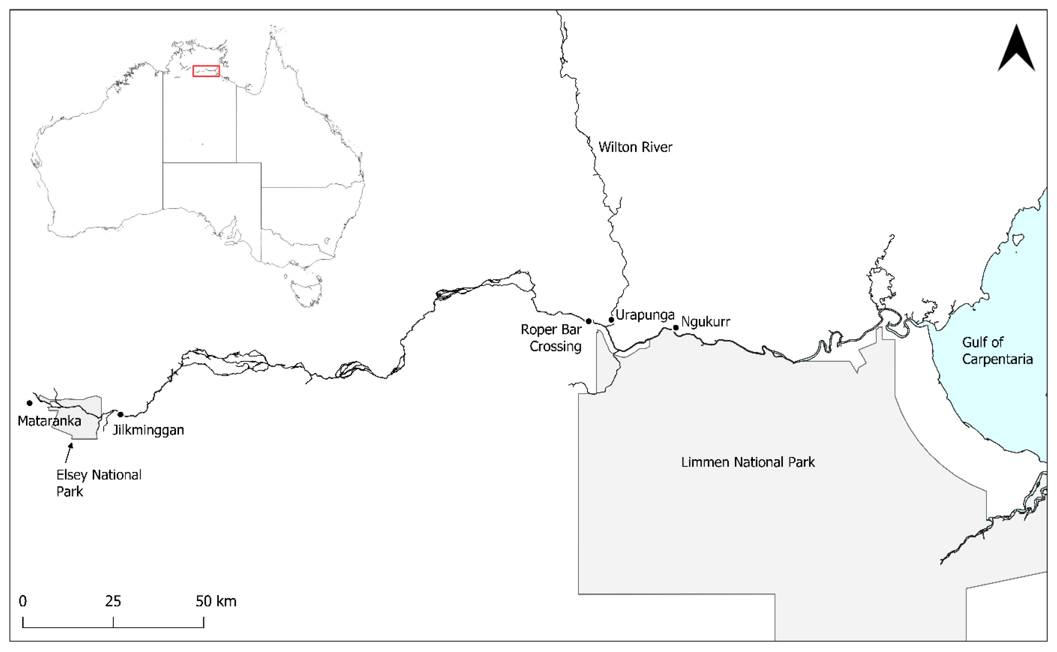
Figure 1. The Roper River in the south-west Gulf of Carpentaria, Northern Territory, Australia.
Preprints 120150 g001
Figure 2. Map of species records in the lower Roper River, Australia. Size of circles indicates the number of animals caught in each location (refer to legend). Circles which appear orange are locations where both G. glyphis and U. dalyensis were recorded.
Preprints 120150 g002
Figure 3. Map of species records in the upper Roper River, Australia. Size of circles indicates the number of animals caught in each location (refer to legend). All but one Pristis pristis locations are approximate based on catch locations described by members of the public. The grey shaded area represents Elsey National Park. Not shown are P. pristis records on the Baghetti (Wilton) River outside the bounds of the map (~150 km from the Wilton/Roper confluence) [17; S. Miller pers. comm., 2024].
Preprints 120150 g003
Disclaimer/Publisher’s Note: The statements, opinions and data contained in all publications are solely those of the individual author(s) and contributor(s) and not of MDPI and/or the editor(s). MDPI and/or the editor(s) disclaim responsibility for any injury to people or property resulting from any ideas, methods, instructions or products referred to in the content.
Copyright: This open access article is published under a Creative Commons CC BY 4.0 license, which permit the free download, distribution, and reuse, provided that the author and preprint are cited in any reuse.
Prerpints.org logo

Preprints.org is a free preprint server supported by MDPI in Basel, Switzerland.

Subscribe

© 2024 MDPI (Basel, Switzerland) unless otherwise stated