Submitted:
02 December 2024
Posted:
03 December 2024
You are already at the latest version
Abstract
Keywords:
1. Introduction
2. Materials
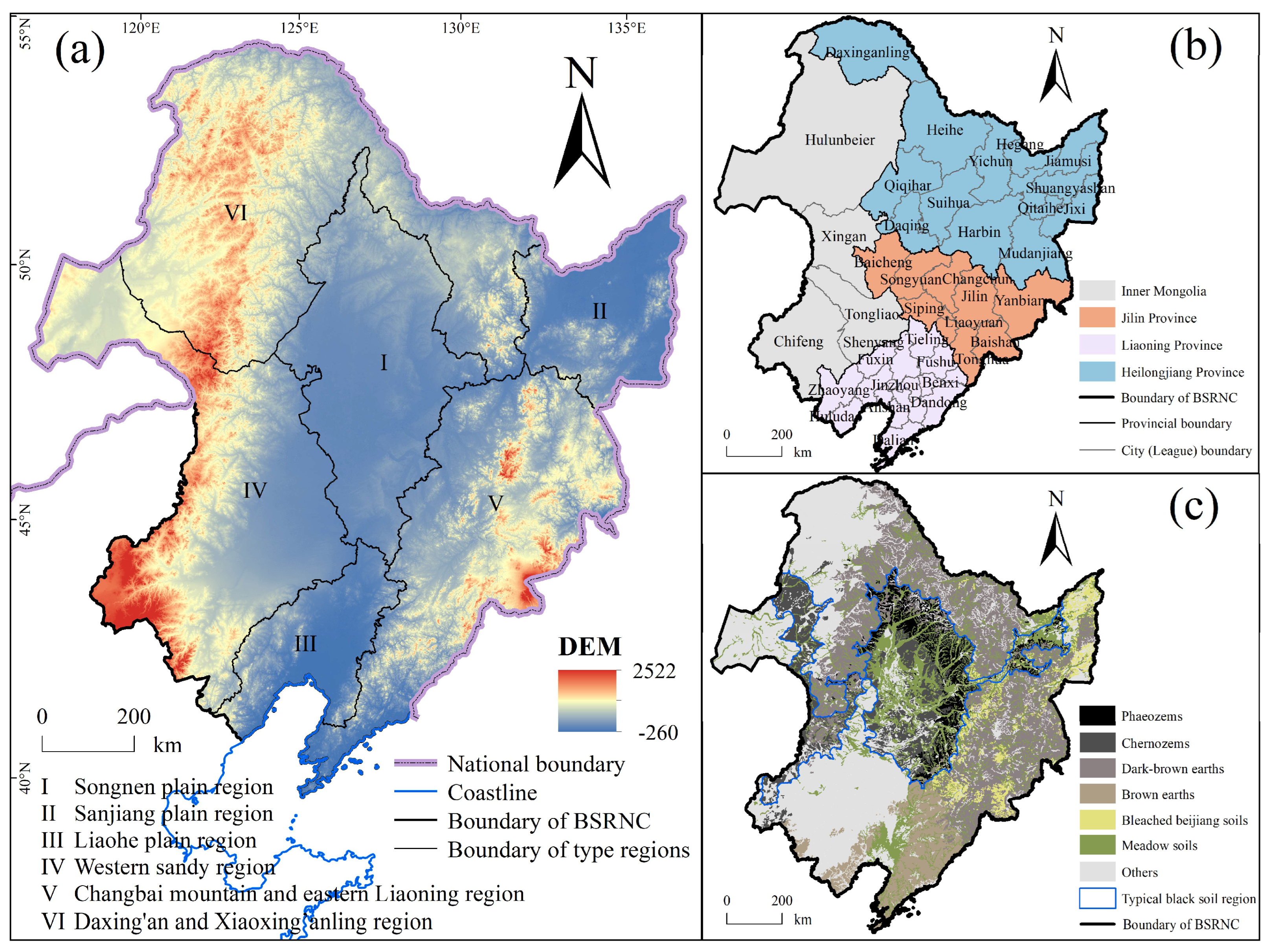
2.1. Study Area
2.2. Data source and Processing
3. Methodology
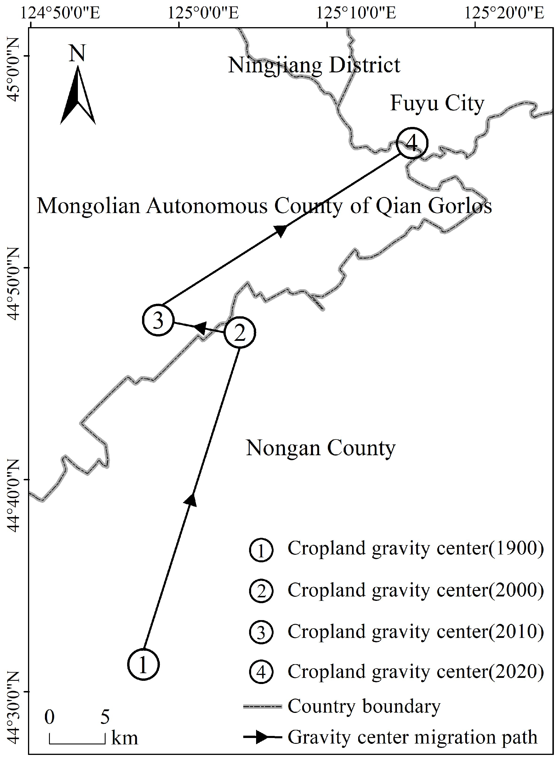
3.1. Cropland Gravity Center Model
3.2. Ecological niche model
3.2.1. Ecological niche connotations of cultivable land
3.2.2. Selection of Factors for Cultivable Land Evaluation
4. Results
4.1. Evolution of Spatial Pattern of Cropland in the BSRNC from 1990 to 2020
4.1.1. Changes in Cropland Quantity
4.1.2. Spatial Changes in Cropland Pattern
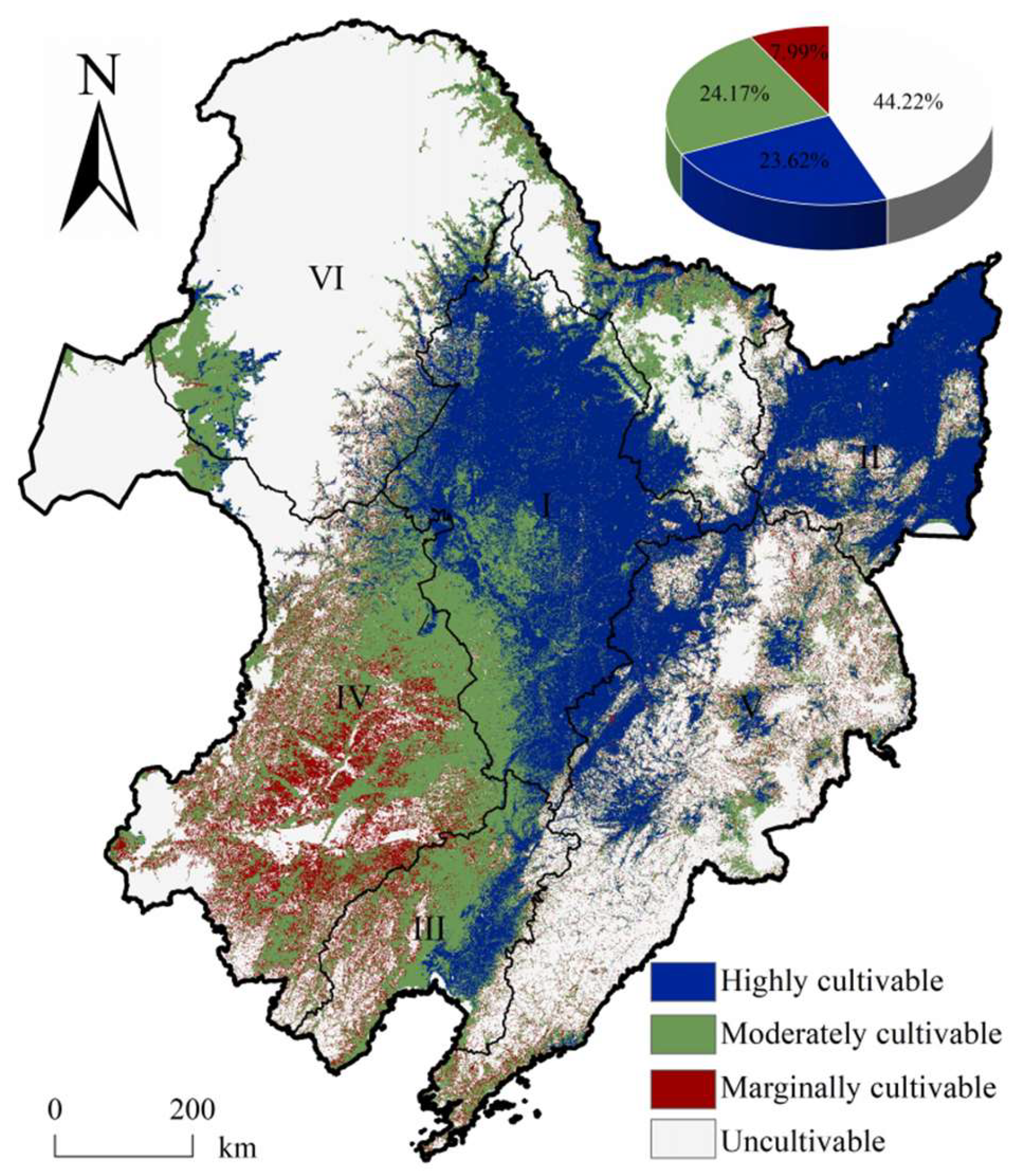
4.2. Cultivable land in the BSRNC
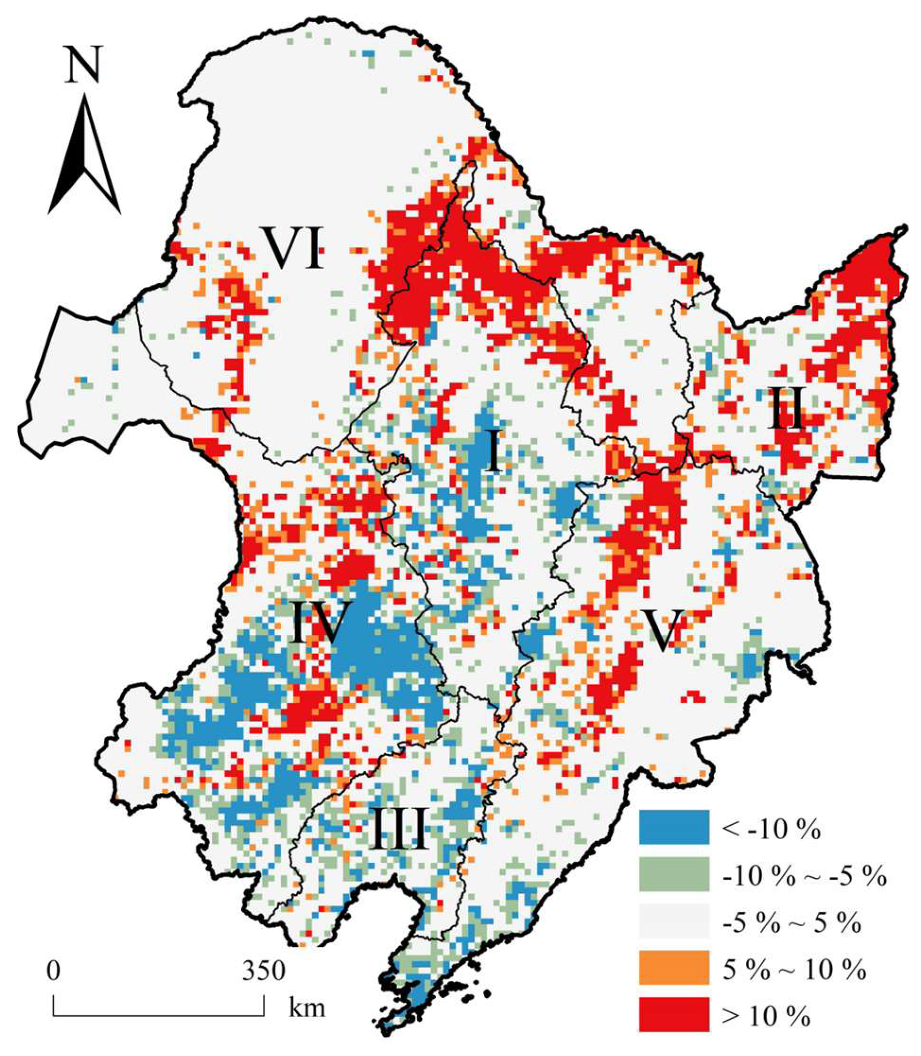
4.3. Changes in Cropland Suitability
5. Discussion
5.1. Assessment of the land cultivability model
5.2. Suggestions for Protecting Cropland in the BSRNC
5.3. Uncertainty analysis
6. Conclusions
Author Contributions
Funding
Data Availability Statement
Conflicts of Interest
References
- FAO, IFAD, UNICEF, WFP, WHO, 2020. In Brief to the State of Food Security and Nutrition in the World 2020. Rome, Italy.
- Ju, H.; Zhang, H.; Yan, Y. Spatial pattern changes of urban expansion and multi-dimensional analysis of driving forces in the Guangdong-Hong Kong-Macao Greater Bay Area in 1980-2020. Acta Geographica Sinica, 2022, 77, 1086–1101. [Google Scholar]
- Zhang, K.; Yu, Z.; Li, X.; Zhou, W.; Zhang, D. Land use change and land degradation in china from 1991 to 2001. Land Degradation & Development, 2007, 18, 209–219. [Google Scholar]
- Song, G.; Zhang, H. Cultivated land use layout adjustment based on crop planting suitability: a case study of typical counties in northeast china. Land, 2021, 10, 107. [Google Scholar] [CrossRef]
- Wang, Y.; Jiang, Y.; Zhu, G. Spatio-temporal evaluation of multi-scales cultivated land system resilience in black soil region from 2000 to 2019: a case study of liaoning province, northeast china. Chinese Geographical Science 2023. [Google Scholar] [CrossRef]
- Zhang, T.; Zhang, F.; Huang, J.; Li, C.; Zhang, B. Spatial pattern evolution of abandoned arable land and its influencing factor in industrialized region. Transactions of the Chinese Society of Agricultural Engineering, 2019, 35, 246–255. [Google Scholar]
- Ye, S.; Song, C.; Shen, S.; Gao, P.; Cheng, C.; Cheng, F.; Wan, C.; Zhu, D. Spatial pattern of arable land-use intensity in china. Land Use Policy, 2020, 99, 104845. [Google Scholar] [CrossRef]
- Dong, X.; Liu, M. Relationships among LUCC, ecosystem services and human well-being. Journal of Beijing Normal University(Natural Science), 2022, 58, 465–475. [Google Scholar]
- Chen, J.; Liu, M.; Chen, X.; Li, Z. Spatio-temporal evolution, driving mechanisms, and simulation of land use and cover in china from 2000 to 2060. Applied Spatial Analysis and Policy, 2024, 17, 1631–1652. [Google Scholar] [CrossRef]
- Yang, Y.; Ma, E.; Liao, L.; Wu, M. Land use change in a typical transect in northern china and its impact on the ecological environment. Sustainability, 2024, 16, 9291. [Google Scholar] [CrossRef]
- Shi, R.; Yang, X. Research on the climate background in arable land changed areas of China. Journal of Geo-information Science, 2010, 12, 309–314. [Google Scholar] [CrossRef]
- Huang, H.; Wen, L.; Kong, X.; Chen, W.; Sun, X. The Impact of Spatial Pattern Evolution of Cultivated Land on Cultivated Land Suitability in China and Its Policy Implication. China Land Science 2021, 35, 61–70. [Google Scholar]
- Li, X.; Wu, K.; Hao, S.; Zhang, Y.; Zhao, R.; Ma, J. Mapping cropland suitability in china using optimized maxent model. Field Crops Research, 2023, 302, 109064. [Google Scholar] [CrossRef]
- Zhou, Y. Cultivated land loss and construction land expansion in china: evidence from national land surveys in 1996, 2009 and 2019. Land Use Policy, 2023, 125, 106496. [Google Scholar] [CrossRef]
- Zhang, R.; Du, G.; Zhang, S. Spatiotemporal changes and the driving factors of cultivated land resources of the typical black soil region in Northeast China from 1986 to 2020. Resources Science, 2023, 45, 939–950. [Google Scholar] [CrossRef]
- Akpoti, K.; Kabo-Bah, A.T.; Zwart, S.J. Review - agricultural land suitability analysis: state-of-the-art and outlooks for integration of climate change analysis. Agricultural Systems, 2019, 173, 172–208. [Google Scholar] [CrossRef]
- Steiner, F.; Dunford, R.; Dosdall, N. The use of the agricultural land evaluation and site assessment system in the united states. Landscape and Urban Planning, 1987, 14, 183–199. [Google Scholar] [CrossRef]
- FAO A Framework for Land Evaluation; Food and Agriculture Organization of the United Nations: Rome, Italy, 1976.
- Shi, Y. Land resource classification system of the three 1:1,000,000 land resource maps in Northeast China. Natural Resources 1979, 1979, 77–90. [Google Scholar]
- Yao, M.; Shao, D.; Lv, C.; An, R.; Gu, W.; Zhou, C. Evaluation of arable land suitability based on the suitability function - a case study of the qinghai-tibet plateau. Science of The Total Environment, 2021, 787, 147414. [Google Scholar] [CrossRef]
- Zhang, G.; Wu, Y.; Zhao, Y. Physical suitability evaluation of reserve resources of cultivated land in China based on SOTER. Transactions of the Chinese Society of Agricultural Engineering, 2010, 26, 1–8. [Google Scholar]
- Zhang, Q.; Li, B.; Zhang, Y.; Wang, S. Suitability evaluation of crop variety via graph neural network. Computational Intelligence and Neuroscience, 2022, 2022, 5614974. [Google Scholar] [CrossRef]
- Agrawal, N.; Govil, H.; Kumar, T. Agricultural land suitability classification and crop suggestion using machine learning and spatial multicriteria decision analysis in semi-arid ecosystem. Environment, Development and Sustainability 2024. [Google Scholar] [CrossRef]
- Qian, J.; Zhao, H.; Wang, X.; Wang, T.; Feng, Z.; Cao, C.; Li, X.; Zhang, A. Declining suitability for conversion of drylands to paddy fields in northeast china: impact of future climate and socio-economic changes. Geography and Sustainability 2024. [Google Scholar] [CrossRef]
- Sadeghfam, S.; Rahmani, M.S.; Moazamnia, M. Mapping climate suitability index for rainfed cultivation of medicinal plants by developing an ai-based probabilistic framework. Scientific Reports, 2024, 14, 20413. [Google Scholar] [CrossRef]
- Shevchenko, V.; Lukashevich, A.; Taniushkina, D.; Bulkin, A.; Grinis, R.; Kovalev, K. Climate change impact on agricultural land suitability: an interpretable machine learning-based eurasia case study. IEEE Access, 2024, 12, 15748–15763. [Google Scholar] [CrossRef]
- Wang, Y.C.; Lu, Y.H.; Chiang, L.C.; Hsu, C.C. Assessing crop suitability of rice, wheat, and maize on agricultural lands in taiwan. Natural Resources Research, 2023, 32, 813–834. [Google Scholar] [CrossRef]
- Yates, K.L.; Bouchet, P.J.; Caley, M.J.; et al. Outstanding challenges in the transferability of ecological models. Trends in Ecology & Evolution, 2018, 33, 790–802. [Google Scholar]
- Ouyang, Z.Y.; Wang, R.; Fu, G. Ecological niche suitability model and itsapplication in land suitability assessment. Acta Ecologica Sinica 1996, 1996, 113–120. [Google Scholar]
- Chen, H.; Yang, R.; Ye, Y. Cultivability evaluation and conservation strategies of land resources in China. Transactions of the Chinese Society of Agricultural Engineering 2023, 39, 192–200. [Google Scholar]
- Zhao, S.; Niu, H.; Zhang, H.; Zhang, X. Construction and application of obstacle diagnosis model based on ecological niche on well- facilitied farmland. Transactions of the Chinese Society for Agricultural Machinery, 2018, 49, 194–202. [Google Scholar]
- Zhao, S.; Niu, H.; Zhang, H.; Zhang, H.; Zhang, X. Suitability evaluation on high quality capital farmland consolidation based on niche-fitness model. Transactions of the Chinese Society of Agricultural Engineering, 2016, 32, 220–228. [Google Scholar]
- Sun, H.; Yang, Z.; Li, X.; Hang, Y.; Gao, M.; Yang, Y.; Meng, X.; Zhu, L. Assessment of the cultivated land quality in the black soil region of northeast china based on the field scale. Environmental Monitoring and Assessment, 2023, 195, 1508. [Google Scholar] [CrossRef] [PubMed]
- Qijun Yang, Ute Wollschläger, Hans-Jörg Vogel, Zhe Feng, Kening Wu. Assessing soil biodiversity potentials in china: a multi-attribute decision approach. Agronomy, 2023, 13, 2822. [Google Scholar] [CrossRef]
- Li, J.; He, H.; Zeng, Q.; Chen, L.; Sun, R. A chinese soil conservation dataset preventing soil water erosion from 1992 to 2019. Scientific Data, 2023, 10, 319. [Google Scholar] [CrossRef]
- Lu, D.; Wang, Z.; Su, K.; Zhou, Y.; Li, X.; Lin, A. Understanding the impact of cultivated land-use changes on china’s grain production potential and policy implications: a perspective of non-agriculturalization, non-grainization, and marginalization. Journal of Cleaner Production, 2024, 436, 140647. [Google Scholar] [CrossRef]
- Qiao, H.; Peterson, A.T.; Myers, C.E.; Yang, Q.; Saupe, E.E. Ecological niche conservatism spurs diversification in response to climate change. Nature Ecology & Evolution, 2024, 8, 729–738. [Google Scholar]
- Xu, Y.; Pei, J.; Li, S.; Zhou, H.; Wang, J.; Zhang, J. Main Characteristics and Utilization Countermeasures for Black Soils in Different Regions of Northeast China. Chinese Journal of Soil Science, 2023, 54, 495–504. [Google Scholar]
- Jia, G.; Hu, W.; Zhang, B.; Li, G.; Shen, S.; Gao, Z.; Li, Y. Assessing impacts of the ecological retreat project on water conservation in the yellow river basin. Science of The Total Environment, 2022, 828, 154483. [Google Scholar] [CrossRef]
- Qi, W.; Liu, S.; Jin, F. Calculation and Spatial Evolution of Population Loss in Northeast China. Scientia Geographica Sinica, 2017, 37, 1795–1804. [Google Scholar]
- Li, Z.; Lv, X.; Yang, Y.; Chen, X.; Niu, S. Evolution Process and Characteristics of Protection Policy for Black Soils in China. Chinese Journal of Soil Science, 2022, 53, 998–1008. [Google Scholar]
- He, C.; Niu, J.R.; Xu, C.T.; Han, S.W.; Bai, W.; Song, Q.L.; Dang, Y.P.; Zhang, H.L. Effect of conservation tillage on crop yield and soil organic carbon in northeast china: a meta-analysis. Soil Use and Management, 2022, 38, 1146–1161. [Google Scholar] [CrossRef]
- Dong, F.; Zhang, Z.; Jiang, F.; Wang, J.; Wang, Q.; Li, L.; Peng, X. Spatial distribution of the buried depth and thickness of albic soil albic layer in sanjiang plain and its influencing factors. Acta Pedologica Sinica 2024, 2024, 1–15. [Google Scholar]
- Liu, B.; Zhang, G.; Xie, Y.; Shen, B.; Gu, Z.; Ding, Y. Delineating the black soil region and typical black soil region of northeastern China. Chin Sci Bull, 2021, 66, 96–106. [Google Scholar] [CrossRef]
- Xu, Z.; Zhang, T.; Wang, S.; Wang, Z. Soil ph and c/n ratio determines spatial variations in soil microbial communities and enzymatic activities of the agricultural ecosystems in northeast china: jilin province case. Applied Soil Ecology, 2020, 155, 103629. [Google Scholar] [CrossRef]
- Bagherzadeh, A.; Gholizadeh, A. Modeling land suitability evaluation for wheat production by parametric and topsis approaches using gis, northeast of iran. Modeling Earth Systems and Environment, 2016, 2, 126. [Google Scholar] [CrossRef]
- Motuma, M.; Suryabhagavan, K.V.; Balakrishnan, M. Land suitability analysis for wheat and sorghum crops in wogdie district, south wollo, ethiopia, using geospatial tools. Applied Geomatics, 2016, 8, 57–66. [Google Scholar] [CrossRef]
- Mugiyo, H.; Chimonyo VG, P.; Sibanda, M.; Kunz, R.; Masemola, C.R.; Modi, A.T.; Mabhaudhi, T. Evaluation of land suitability methods with reference to neglected and underutilised crop species: a scoping review. Land, 2021, 10, 125. [Google Scholar] [CrossRef]
- Chen, W.; Ye, X.; Li, J.; Fan, X.; Liu, Q.; Dong, W. Analyzing requisition–compensation balance of farmland policy in china through telecoupling: a case study in the middle reaches of yangtze river urban agglomerations. Land Use Policy, 2019, 83, 134–146. [Google Scholar] [CrossRef]
- Liu, C.; Song, C.; Ye, S.; Cheng, F.; Zhang, L.; Li, C. Estimate provincial-level effectiveness of the arable land requisition-compensation balance policy in mainland china in the last 20 years. Land Use Policy, 2023, 131, 106733. [Google Scholar] [CrossRef]
- Bi, W.; Dang, X.; Ma, H.; Deng, M.; Li, P.; Cao, X.; Shi, P. Evaluation of arable land suitability and potential from the perspective of “Food Crop Production Strategy based on Farmland Management” in northwest China. Transactions of the Chinese Society of Agricultural Engineering, 2021, 37, 235–243. [Google Scholar]
| Data | Time resolution | Space resolution | Format | Data source |
|---|---|---|---|---|
| ≥10 °C active accumulated temperature (AT) | 1971–2000 | 1 km | Raster | http://www.nesdc.org.cn |
| Annual precipitation (AP) | 1980–2018 | 1 km | Raster | www.gis5g.com |
| ASTER GDEM | \ | 30 m | Raster | http://www.gscloud.cn |
| Potential annual soil erosion (SEp) | 1999–2019 | 1 km | Raster | Li et al. (2023) [35] |
| Thickness | 2010–2018 | 1 km | Raster | http://www.geodata.cn |
| Soil organic carbon | 2010–2018 | 1 km | Raster | |
| Soil pH | 2010–2018 | 1 km | Raster | |
| Soil texture | 2010–2018 | 1 km | Raster | |
| Land use | 1990, 2000, 2010, 2020 | 30 m | Raster | www.resdc.cn |
| Indicators | Indicator types | Optimum value | Limit value | Basis for parameterisation |
| ≥10 °C active accumulated temperature (AT) | I | ≥ 3200 ℃ | ≤ 1800 ℃ | Standards of surveying and evaluating reserved land resource for cultivation (standard no. TD / T 1007 - 2003) |
| Annual precipitation (AP) | I | ≥ 650 mm | ≤ 350 mm | |
| Potential annual soil erosion (SEp) | III | 50 t·ha-1·a-1 | 300 t·ha-1·a-1 | Standards for classification and gradation of soil erosion (standard no. SL 190 - 2007) |
| Slope | III | ≤ 2° | > 25° | Regulations for classification on agriculture land (standard no. GB / T 28405 - 2012); Cultivated land quality grade (standard no. GB / T 33469 - 2016) |
| Soil thickness | I | ≥ 150 cm | ≤ 60 cm | |
| Soil texture | I | Slit, sandy loam, loam, silt loam, sandy clay loam, clay loam, silty clay loam | Sand | |
| Soil pH | II | 6.0 ≤ pH <7.9 | pH < 4.5, pH ≥ 9.5 | |
| Soil organic matter (SOM) | I | ≥ 4 % | ≤ 0.6 % |
| Indicators | Indicator classification | Score |
|---|---|---|
| Soil texture | Slit, sandy loam, loam, silt loam, sandy clay loam, clay loam, silty clay loam | 100 |
| Clay, silty clay, sandy clay | 80 | |
| Loamy sand | 60 | |
| sand | 0 | |
| Soil pH | 6.0 ≤ pH <7.9 | 100 |
| 5.5 ≤ pH < 6.0, 7.9 ≤pH < 8.5 | 90 | |
| 5.0 ≤ pH < 5.5, 8.5 ≤ pH < 9.0 | 80 | |
| 4.5 ≤ pH < 5.0, 9.0 ≤ pH < 9.5 | 60 | |
| pH < 4.5, pH ≥ 9.5 | 0 |
| 1990 | 2000 | 2010 | 2020 | 1990—2020 | |
| Cropland area / 103 km2 | 446.62 | 456.60 | 444.81 | 453.78 | — |
| Area proportion / % | 35.93 | 36.74 | 35.79 | 36.51 | — |
| Amount of area change / 103 km2 | — | 9.97 | -11.78 | 8.97 | 7.16 |
| Rate of area change / % | — | 2.23 | -2.58 | 2.02 | 1.60 |
| Type regions | cultivability score | AT10 | AP | SEp | Slope | Texture | Thickness | pH | SOM |
|---|---|---|---|---|---|---|---|---|---|
| SNP | 83.06 | 83.44 | 79.58 | 94.55 | 90.88 | 99.79 | 90.37 | 96.82 | 71.24 |
| SJP | 75.23 | 80.43 | 92.09 | 79.50 | 85.87 | 94.24 | 67.85 | 99.43 | 94.18 |
| LHP | 58.24 | 99.59 | 86.90 | 61.75 | 83.24 | 99.27 | 81.29 | 99.80 | 33.80 |
| WS | 43.29 | 75.12 | 57.09 | 78.33 | 84.63 | 89.85 | 71.92 | 95.62 | 44.63 |
| CMEL | 36.97 | 75.32 | 97.79 | 37.02 | 67.43 | 99.57 | 54.48 | 95.99 | 82.33 |
| DXXAL | 22.54 | 23.54 | 81.15 | 71.20 | 76.22 | 99.76 | 45.35 | 93.82 | 96.60 |
Disclaimer/Publisher’s Note: The statements, opinions and data contained in all publications are solely those of the individual author(s) and contributor(s) and not of MDPI and/or the editor(s). MDPI and/or the editor(s) disclaim responsibility for any injury to people or property resulting from any ideas, methods, instructions or products referred to in the content. |
© 2024 by the authors. Licensee MDPI, Basel, Switzerland. This article is an open access article distributed under the terms and conditions of the Creative Commons Attribution (CC BY) license (http://creativecommons.org/licenses/by/4.0/).


