
Submitted:
10 December 2024
Posted:
10 December 2024
You are already at the latest version
Abstract
The accumulation of big data by intelligent and information systems in transportation has created a basis for the use of various methods of forecasting and operational management of the transportation process. One of the promising directions in this area is the description of both traffic flows and the structure of transportation systems in the form of spatiotemporal graphs. Optimization of such graphs makes it possible to justify management decisions in real time, as well as to forecast the parameters of traffic flows and transport process. The purpose of the study is to identify trends in the use of spatiotemporal graphs for solving various problems in transportation, as well as the most common methods of optimization of such graphs. The sample papers studied include 114 publications from Scopus Database for 25 years from 1999 to 2024. First, a bibliometric analysis was conducted to establish the increase in the number of publications, journals, countries, institutions, subject areas, articles, authors, and keyword matches to understand the amount of literature generated. Secondly, a literature review was conducted based on content analysis to predict future research directions in the field. It was found that a promising direction is the development of deep learning methods and ways to form graph neural networks based on the use of spatiotemporal graph. Such methods are most often used to solve the tasks of real-time control of urban transportation systems. The least number of publications is in areas that require in-depth knowledge of transportation technology, such as air, sea, and rail transportation. This study has contributed to the expansion of scientific knowledge on methods of spatiotemporal optimization of transport systems based on bibliometric analysis.
Keywords:
spatiotemporal graphs
; optimization methods
; transportation systems
; bibliometric analysis
; Scopus Database
1. Introduction
The tasks of transportation systems management are the most complex in science and become especially relevant in the conditions of increasing uncertainty of the external environment and increasing complexity of transportation systems themselves [1]. Improvement of information technologies [2], intensive spread of Industry 4.0 [3] and Internet of Things concepts [4] have formed prerequisites for obtaining large amounts of current reliable data on the parameters of transportation systems. Insufficient development of optimization methods based on large volumes of operational data limits the accuracy of the results of their use and reduces the efficiency of management. In transportation systems, the structure of space topology dynamically depends both on the parameters of transportation flows [5] and individual elements of these flows.
A promising way to overcome these limitations is to combine graph theory methods and optimization methods. Currently, there is an intensive development of graph theory in the direction of developing new methods of optimization to use them for solving a wide range of applied problems [6]. However, the use of traditional methods of describing the space of complex topology using graphs has limitations. It relates to two main factors — peculiarities of topology of transport systems, especially railway transport systems, and dynamism of parameters of transport flows in a broad sense. The topology factor determines the need to use or additional constraints in the process of solving optimization issues on spatial graphs, or the use of spatial graphs of special or new types. The factor of traffic flow dynamics affects the dimensionality of temporal graphs, complicating such graphs for solving optimization and forecasting issues using most known methods.
The problem of improving the accuracy of system state prediction based on the development of graph structure optimization methods has been considered in a discrete formulation until recently. The result of this approach is the multivariate structure of graphs used to describe complex transportation systems. Most of the known algorithms for predicting the state of transportation systems are based on the use of heuristic and meta-heuristic methods [7]. These algorithms are characterized by insufficient accuracy of predicting the state of complex transport systems [8].
The use of combined spatiotemporal graphs potentially allows creating more accurate and computationally efficient, as compared to known, methods of describing and predicting the state of complex transportation systems [9]. The need to expand the understanding of the state of research in the use of spatiotemporal graph optimization methods in transportation and the prospects for the development of these methods as applied to complex control problems required a systematic literature review.
We searched for review articles in the Scopus database to identify previous similar studies. The keywords “Spatiotemporal graph” AND “Review” were used for the query. As a result, 36 review articles were found. Most existing literature reviews show a disciplinary focus of research, especially in areas related to the use of the “Spatiotemporal graph” in neuroscience, medicine, biochemistry, genetics and molecular biology, and computer science. Out of 36 articles, only one article is related to the topic of this study, and it is a review of machine learning-based traffic prediction methods [10]. Therefore, this study uses a systematic literature review methodology to synthesize graph theory research as applied to transportation systems of different modes and varying complexity.
This paper aims to fill the gap in the analysis of scientific papers on the use of spatiotemporal optimization methods for transportation systems by conducting a systematic literature review over a 25-year period from 1999 to 2024. The main scientific contributions of this paper are:
1. Formation of a comprehensive view of the research environment that links spatiotemporal graphs, optimization methods and transport systems of different modes of transport.
2. Identification of the main tasks and methods of spatiotemporal optimization of transport systems based on bibliometric and content analysis of scientific publications.
3. Identification of future research directions in spatiotemporal optimization of transport systems to fill the research gap.
To comprehensively evaluate and analyze the existing research, identify the tasks and areas of application of “Spatiotemporal graph” in transportation, as well as to identify promising directions for the development of “Spatiotemporal graph” in the future, we formulated the following questions.
1. What quantitative and qualitative changes have been observed in publications on the application of the “Spatiotemporal graph” as applied to transportation systems?
2. Which authors and organizations and from which countries contribute to the development of scientific knowledge in the field of “Spatiotemporal graph” application to transport systems?
3. What are the most cited publications, and which scientific journals most frequently publish research on the use of “Spatiotemporal graph” in transportation systems?
4. What problems and methods of spatiotemporal optimization of transport systems are actual and perspective in the future?
The structure of the article consists of four sections. After the “Introduction” section, the “Research Method” section presents a description of the research methodology. The “Analysis Results” section contains the results of bibliometric analysis and content analysis of publications from the Scopus database, as well as the systematization of spatiotemporal optimization problems and methods as applied to transport systems. Finally, the “Conclusion” section concludes the paper by summarizing the results of the study and pointing out its limitations.
2. Research Method
A systematic literature review aims to identify, evaluate, interpret and categorize research papers addressing one or more research questions and topics. The main steps of the systematic review methodology in this study are [11]:
1. Defining the research questions: formulating the research questions that need to be answered.
2. Literature search and selection: developing a strategy to search for documents with different combinations of keywords to get the most comprehensive overview of the research area. Setting up filters to obtain the most relevant sample of articles.
3. Bibliometric analysis: presenting quantitative analysis and data visualization of the selected sample of articles to understand the key characteristics of the study area, including publication, journal and citation trends, collaboration and keyword focus.
4. Content analysis: analyzing the content of the articles selected in the second step of this methodology to understand the content of current and prospective research.
The Scopus database was used in this study to conduct a research trend analysis of the literature on the application of spatiotemporal optimization methods to solve actual problems in the operation of various transportation systems. The Scopus database covers a large volume of scientific publications, which provides a rich and diverse dataset for a systematic literature review and reliable analysis results.
We used the following rules to collect relevant literature:
- The papers should contain the keywords “Spatiotemporal graph” and “Transport systems”. The filter [Article title, Abstract, Keywords] was used as criteria for selection of publications.
- Papers should be indexed in the Scopus database and should include articles in peer-reviewed English language journals, conference proceedings and book chapters on the field under study.
As software, spreadsheets were used to perform statistical analysis of publication search results, and VOSviewer [12] was used to visually represent and analyze the keyword network.
Figure 1 presents the scheme of the research methodology. The PRISMA Flow Diagram [13] approach was used to determine the number of papers selected for analysis, considering the exclusion of duplicates, as well as papers not relevant to the field of study. The total number of selected papers for bibliometric analysis and content analysis was 114 publications.
3. Results
Studies on the use of spatiotemporal graphs for transportation systems of various complexity appeared in the late 90s and became the most popular in the past five years — this period accounts for about 89% of indexed papers. Figure 2 shows the dynamics of the number of scientific papers indexed in the Scopus database in the period from 1999 to 2024. Since 2019, there is a significant increase in the number of publications, which shows the increasing interest of researchers in the use of spatiotemporal graphs to describe and model the operation of various transportation systems.
Most papers (about 93%) are published in English, and up to 80% of papers are published articles in scientific journals (Figure 3).
Analysis of the distribution of papers by scientific journals shows wide coverage of various resources indexed in the Scopus database. The list of journals includes 63 titles. The top five journals by number of publications were Transportation Research Part C Emerging Technologies (11 papers), IEEE Transactions on Intelligent Transportation Systems (7 papers), IEEE Access (5 papers), Sustainability (Switzerland) (4 papers), and Computers Environment And Urban Systems (3 papers). In 15 journals, 2–3 papers were published each. In 43 journals, we found only one paper each. The number of these journals is shown in the “Other sources” column in Figure 4. The other columns of the diagram in this figure correspond to journals with more than two publications.
Figure 5 shows the distribution of publications by different branches of knowledge or subject areas. The topics of the articles are related to many subject areas, ranging from computer science, engineering, social sciences, and mining sciences. The diversity of subject areas indicates not only the importance of the topic under study, but also the interdisciplinary nature of the issues related to the use of spatio-temporal graph methods for optimization of transport systems.
Figure 6 shows the distribution of the analyzed publications by the countries to which the authors were affiliated. The leader in the number of publications is China (66 papers). In addition to China, the top five countries by publications are the United States of America (17 papers), Hong Kong (12 papers), the United Kingdom (8 papers), and South Korea (6 papers). One publication per country was found in 17 countries, including Austria, Brazil, Canada, Egypt, Indonesia, Netherlands, Norway, Poland, Portugal, Qatar, Russian Federation, Saudi Arabia, Slovakia, Spain, Sweden, Switzerland, Taiwan. The Scopus database did not identify publications on the subject of the study from the countries of Central, Eastern and Southern Africa, Central Asia, and South America, except Brazil.
The leading organizations with which authors with the largest number of scientific articles on the research topic are affiliated are Chinese Academy of Sciences (7 papers), Hong Kong University of Science and Technology (6 papers), The Hong Kong Polytechnic University (6 papers), Beijing Jiaotong University (5 papers), The University of Hong Kong (4 papers). In total, the analysis identified 160 organizations from 34 countries.
The analysis of publication citations indicated that the first citation appeared in 1999, and the total number of citations reached 1728 at the time of the study. 87 papers out of 114 were cited in the Scopus database at least once, which is 76%.
The most cited articles at the time of the study are presented in Table 1. The most attention of researchers is drawn to the areas related to modeling and control of traffic in urban networks [14], bike sharing systems [15,16], traffic speed prediction in Intelligent Transport Systems [17], as well as forecasting demand for urban taxi rides within an online car-hailing system [18].
The keyword analysis was performed by dividing the papers by year of publication into two periods — from 1999 to 2018 and from 2019 to 2024. This division is justified by the sharp increase in the number of publications starting from 2019. In the papers of the first period, 194 keywords were identified. The keywords are grouped into three clusters: red, blue, and green (Figure 8), each represented by four main areas with high linkage strength.
The red cluster reflects the relevance of the issues of “complex network” formation. Research topics are devoted to the assessment of air network development in China, modeling and traffic management in urban networks. The blue cluster covers the problems of “travel time”. The subject of works covers air and urban modes of transport, is devoted to estimation of vehicle travel time, passenger departure time, modeling of road users' behavior and estimation of probable spatial and temporal travel paths. The green cluster “transportation” reflects the solution of problems related to the transportation of dangerous goods, route selection in multimodal transport systems, as well as modeling the spatial location of transport hubs.
In the papers published during the second analysis period from 2019 to 2024, 1318 keywords were identified. In further analysis, all keywords are grouped into four clusters and include 29 main areas (Figure 9). The red cluster includes 9 domains – Graph, Data, Approach, Algorithm, Graphic method, Public transportation, Demand prediction, Bicycle, Covid. Green cluster includes 9 areas – Street, Road, Motor transportation, Road network, Traffic prediction, Travel time, Spatio temporal data. Blue cluster includes 8 areas - Graph convolutional network, Spatio, Convolutional network, Traffic flow prediction, Traffic forecasting, Intelligent transportation systems, Intelligent vehicle highway system. Yellow cluster includes 3 areas – Transportation systems, Traffic management, China.
In addition to the keyword analysis, all papers were grouped by areas of application of spatiotemporal graph as applied to different modes of transportation or transportation systems (Table 2). Despite the interdisciplinary nature of the majority of publications on each mode of transportation, specific areas of application can be applied to individual elements of transportation systems — transport communications and infrastructure, vehicles, road users, control systems, information-telecommunication systems, etc.
Recently, there has been an increased interest of researchers in the field of transport systems management in the use of various real-time spatiotemporal optimization methods to solve a wide range of decision support problems. Such methods are applied to traffic (34 papers) and passenger flow forecasting (5 papers), route and trip planning (13 papers), vehicle allocation (demand forecasting), vehicle sharing forecasting (29 papers), and monitoring the use of transport infrastructure by different modes of transport (33 papers).
Based on the results of the content analysis of publications, we grouped the methods of spatiotemporal optimization into groups and subgroups (Table 3). The most frequently used methods for spatiotemporal graph optimization are mathematical programming methods (linear programming, multi-criteria analysis, dynamic programming), graph theory (simple graph, dynamic graphs and methods of generalizing their structure, spatiotemporal graph and methods of its formation, biological graphs), heuristic methods (heuristic strategies, feed forward neural networks, convolutional neural networks (CNNs), graph convolutional neural networks (GCNs), graph neural networks (GNNs), and other methods).
Content analysis has shown the most significant number of uses of heuristic methods of spatiotemporal optimization for solving real-time decision support problems (90 publications). Neural networks and methods of machine and deep learning are used to consider spatiotemporal dependencies of complex transportation systems with the required accuracy (73 publications). A promising direction is the use of graph neural networks (16 publications) and methods for their training. A distinctive feature of graph neural networks is the possibility to use a spatiotemporal graph without additional transformations. Machine learning methods (19 publications) and methods of their combination (deep learning methods) (11 publications) are used for training such neural networks.
The results of the paper analysis show the interest of researchers in combining graphs with methods of mathematical statistics and analysis, optimization, numerical methods, probability theory, multi-criteria analysis for training neural networks. The basis of such deep learning methods are ways of transforming data on transportation system parameters into spatiotemporal estimates of the graph. No publications using the popular simulation method for both training neural networks and solving spatiotemporal optimization problems have been identified.
Most of the publications reflect the use and development of spatiotemporal optimization methods for solving problems of both real-time management of urban transport systems and planning tasks. The smallest number of publications are observed in the areas of rail, sea and air transportation. For example, when using methods of spatiotemporal optimization of railway transport systems, it is necessary to consider the technology of the transportation process and the specifics of management. On the one hand, the accuracy of data conversion into spatiotemporal graph estimates depends on the correctness of the transportation process technology description. On the other hand, the management process in railway transportation is accompanied by many variations of sequences of technological operations. Depending on the choice of a certain variant of such a sequence, different changes in the state of the railway transportation system are observed.
4. Conclusions
Recently, there has been interest in the field of transport systems management in the use of various methods of spatiotemporal optimization in real time to solve the problems of forecasting traffic and passenger flows, planning routes and trips, distribution of vehicles, forecasting the joint use of vehicles, monitoring the use of transport infrastructure by different types of transport.
The results of the conducted systematic literature review of publications show the intensive development of spatiotemporal optimization methods based on the use of spatiotemporal graphs for predicting the dynamics of space topology structure depending on the parameters of transport flows. The special interest of researchers to the use of spatiotemporal graphs in heuristic methods is revealed.
A promising direction is the development of deep learning methods and methods of forming graph neural networks based on the use of spatiotemporal graphs. Such methods are most often used to solve the problems of real-time control of urban transportation systems.
The least number of publications are observed in the areas requiring in-depth knowledge of transportation technology, such as air, sea, and railway transport. This is because the result of spatial and temporal optimization, and consequently, the forecast values of transport system parameters depend on the correctness and detail of the description of the specifics and technology of a particular transportation process. A multitude of specific constraints and requirements related to transportation safety must be observed in transportation management in these modes of transportation.
The systematic review allowed us to identify both missing areas and prospects for research on the use of spatiotemporal optimization of transport systems. Such research should be focused on the development of deep learning algorithms of graph neural networks for predicting the parameters of transportation systems by determining the optimal sequences of changes in their state. The most promising types of transport for the application of spatiotemporal optimization methods are transport systems of railway, air and sea transport.
Author Contributions
Conceptualization, A.R. and N.O.; methodology, A.R. and N.O.; software, N.O.; validation, N.O. and A.R.; formal analysis, N.O.; investigation, N.O. and P.M.; resources, A.R.; data curation, N.O. and P.M.; writing—original draft preparation, N.O. and P.M.; writing—review and editing, A.R.; visualization, N.O.; supervision, A.R.; project administration, A.R.; funding acquisition, N.O. and A.R. All authors have read and agreed to the published version of the manuscript.
Funding
The work was carried out with the financial support of the Russian Science Foundation No. 23-11-00164, https://rscf.ru/project/23-11-00164/ (accessed on 08 December 2024).
Data Availability Statement
Data is contained within the article.
Acknowledgments
Thanks in advance to the anonymous reviewers for their help with the article.
Conflicts of Interest
The authors declare no conflicts of interest.
References
- Rakhmangulov, A.; Kornilov, S.; Kolga, A. Timeliness of freight traffic in transport technological systems. Vestnik of Nosov Magnitogorsk State Technical University 2014, 45, 115–121.
- Rakhmangulov, A.; Sładkowski, A.; Osintsev, N. Design of an ITS for industrial enterprises. In Intelligent Transportation Systems – Problems and Perspectives; Sładkowski, A., Pamuła, W., Eds.; Springer International Publishing: Cham, 2016; pp 161–215, ISBN 978-3-319-19149-2.
- Laiton-Bonadiez, C.; Branch-Bedoya, J.W.; Zapata-Cortes, J.; Paipa-Sanabria, E.; Arango-Serna, M. Industry 4.0 technologies applied to the rail transportation industry: A systematic review. Sensors (Basel) 2022, 22. [CrossRef]
- Kljaić, Z.; Pavković, D.; Cipek, M.; Trstenjak, M.; Mlinarić, T.J.; Nikšić, M. An overview of current challenges and emerging technologies to facilitate increased energy efficiency, safety, and sustainability of railway transport. Future Internet 2023, 15, 347. [CrossRef]
- Rakhmangulov, A.; Sładkowski, A.; Osintsev, N.; Mishkurov, P.; Muravev, D. Dynamic Optimization of Railcar Traffic Volumes at Railway Nodes. In Rail Transport—Systems Approach; Sładkowski, A., Ed.; Springer International Publishing: Cham, 2017; pp 405–456, ISBN 978-3-319-51501-4.
- Cheramangalath, U.; Nasre, R.; Srikant, Y.N. Distributed Graph Analytics; Springer International Publishing: Cham, 2020, ISBN 978-3-030-41885-4.
- Mahmudy, W.F.; Widodo, A.W.; Haikal, A.H. Challenges and opportunities for applying meta-heuristic methods in vehicle routing problems: A review. In The 7th Mechanical Engineering, Science and Technology International Conference. Mechanical Engineering, Science and Technology International Conference; MDPI: Basel Switzerland, 2024; p 12.
- Murrar, S.; Alhaj, F.M.; Qutqut, M. Machine learning algorithms for transportation mode pprediction: A comparative analysis. Informatica 2024, 48. [CrossRef]
- Zhao, S.; Xing, S.; Mao, G. An Attention and Wavelet Based Spatial-Temporal Graph Neural Network for Traffic Flow and Speed Prediction. Mathematics 2022, 10, 3507. [CrossRef]
- Cui, J.-X.; Yao, J.; Zhao, B.-Y. Review on short-term traffic flow prediction methods based on deep learning. Journal of Traffic and Transportation Engineering 2024, 24, 50–64. [CrossRef]
- Sun, X.; Yu, H.; Solvang, W.D.; Wang, Y.; Wang, K. The application of Industry 4.0 technologies in sustainable logistics: a systematic literature review (2012-2020) to explore future research opportunities. Environ. Sci. Pollut. Res. Int. 2022, 29, 9560–9591. [CrossRef]
- VOSviewer. Available online: https://www.vosviewer.com/ (accessed on 8 December 2024).
- PRISMA. Available online: https://www.prisma.io/ (accessed on 8 December 2024).
- Saeedmanesh, M.; Geroliminis, N. Clustering of heterogeneous networks with directional flows based on “Snake” similarities. Transportation Research Part B: Methodological 2016, 91, 250–269. [CrossRef]
- Zhou, X. Understanding spatiotemporal patterns of biking behavior by analyzing massive bike sharing data in Chicago. PLoS One 2015, 10, e0137922. [CrossRef]
- Yang, Y.; Heppenstall, A.; Turner, A.; Comber, A. A spatiotemporal and graph-based analysis of dockless bike sharing patterns to understand urban flows over the last mile. Computers, Environment and Urban Systems 2019, 77, 101361. [CrossRef]
- Zhang, C.; Yu, J.J.Q.; Liu, Y. Spatial-Temporal Graph Attention Networks: A Deep Learning Approach for Traffic Forecasting. IEEE Access 2019, 7, 166246–166256. [CrossRef]
- Jin, G.; Cui, Y.; Zeng, L.; Tang, H.; Feng, Y.; Huang, J. Urban ride-hailing demand prediction with multiple spatio-temporal information fusion network. Transportation Research Part C: Emerging Technologies 2020, 117, 102665. [CrossRef]
- Rathore, M.M.; Attique Shah, S.; Awad, A.; Shukla, D.; Vimal, S.; Paul, A. A cyber-physical system and graph-based approach for transportation management in smart cities. Sustainability 2021, 13, 7606. [CrossRef]
- Qin, K.; Xu, Y.; Kang, C.; Kwan, M.-P. A graph convolutional network model for evaluating potential congestion spots based on local urban built environments. Transactions in GIS 2020, 24, 1382–1401. [CrossRef]
- Kyriakou, K.; Lakakis, K.; Savvaidis, P.; Basbas, S. Analysis of spatiotemporal data to predict traffic conditions aiming at a smart navigation system for sustainable urban mobility. Archives of Transport 2019, 52, 27–46. [CrossRef]
- Furno, A.; Faouzi, N.-E.E.; Sharma, R.; Zimeo, E. Graph-based ahead monitoring of vulnerabilities in large dynamic transportation networks. PLoS One 2021, 16, e0248764. [CrossRef]
- Zhao, P.; Liu, X.; Shen, J.; Chen, M. A network distance and graph-partitioning-based clustering method for improving the accuracy of urban hotspot detection. Geocarto International 2019, 34, 293–315. [CrossRef]
- Myrovali, G.; Karakasidis, T.; Charakopoulos, A.; Tzenos, P.; Morfoulaki, M.; Aifadopoulou, G. Exploiting the knowledge of dynamics, correlations and causalities in the performance of different road paths for enhancing urban transport management. In Decision Support Systems IX: Main Developments and Future Trends; Freitas, P.S.A., Dargam, F., Moreno, J.M., Eds.; Springer International Publishing: Cham, 2019; pp 28–40, ISBN 978-3-030-18818-4.
- Tygesen, M.N.; Pereira, F.C.; Rodrigues, F. Unboxing the graph: Towards interpretable graph neural networks for transport prediction through neural relational inference. Transportation Research Part C: Emerging Technologies 2023, 146, 103946. [CrossRef]
- Tang, H.; Wu, Y.; Guo, Z. Graph multi-attention network-based taxi demand prediction. In 2022 4th International Conference on Data-driven Optimization of Complex Systems (DOCS). 2022 4th International Conference on Data-driven Optimization of Complex Systems (DOCS), Chengdu, China, 28–30 Oct. 2022; IEEE, 10282022; pp 1–6, ISBN 978-1-6654-5982-2.
- Lyu, C.; Wu, X.; Liu, Y.; Liu, Z. A partial-fréchet-distance-based framework for bus route identification. IEEE Transactions on Intelligent Transportation Systems 2022, 23, 9275–9280. [CrossRef]
- Lee, K.; Park, J.S.; Goh, S.; Choi, M. Accessibility measurement in transportation networks and application to the Seoul bus system. Geographical Analysis 2019, 51, 339–353. [CrossRef]
- Hou, M.; Xia, F.; Chen, X.; Saikrishna, V.; Chen, H. Adaptive spatio-temporal graph learning for bus station profiling. ACM Transactions on Spatial Algorithms and Systems 2024, 10, 1–23. [CrossRef]
- Xiao, S.; Shi, Q.; Shao, L.; Du, B.; Wang, Y.; Shen, Q.; Zeng, W. MetroBUX: A Topology-Based Visual Analytics for Bus Operational Uncertainty EXploration. IEEE Transactions on Intelligent Transportation Systems 2024, 25, 5525–5538. [CrossRef]
- Peng, J.; Zhang, G.; Wang, T.; Wang, P.; Zhang, T. A trajectory-driven multi-layer spatiotemporal graph neural network for predicting short-term urban traffic state. Journal of Geo-information Science 2024, 26, 2300–2315. [CrossRef]
- Li, W.; Liu, C.; Wang, T.; Ji, Y. An innovative supervised learning structure for trajectory reconstruction of sparse LPR data. Transportation 2024, 51, 73–97. [CrossRef]
- Tang, J.; Zeng, J. Spatiotemporal gated graph attention network for urban traffic flow prediction based on license plate recognition data. Computer-Aided Civil and Infrastructure Engineering 2022, 37, 3–23. [CrossRef]
- Chen, Y.; He, Z. Vehicle identity recovery for automatic number plate recognition data via heterogeneous network embedding. Sustainability 2020, 12, 3074. [CrossRef]
- Zhao, X.; Zhang, M. Enhancing predictive models for on-street parking occupancy: Integrating adaptive GCN and GRU with household categories and POI factors. Mathematics 2024, 12, 2823. [CrossRef]
- Chen, T.; Sun, C. An optimization design of hybrid parking lots in an automated environment. Sustainability 2023, 15, 15475. [CrossRef]
- Ma, W.; Pi, X.; Qian, S. Estimating multi-class dynamic origin-destination demand through a forward-backward algorithm on computational graphs. Transportation Research Part C: Emerging Technologies 2020, 119, 102747. [CrossRef]
- Boulmakoul, A.; Karim, L.; Laarabi, M.H.; Sacile, R.; Garbolino, E. MongoDB-hadoop distributed and scalable framework for spatio-temporal hazardous materials data warehousing. In Proceedings of the 7th International Congress on Environmental Modelling and Software. 7th International Congress on Environmental Modeling and Software (iEMSs), June 15–19, 2014; San Diego, California, USA, 2014; pp 2255–2262.
- Mimeur, C.; Thévenin, T. Diachronic analysis of the growth of the French railway network between 1860 and 1930: Connectionist expansion and hierarchical selection? Flux 2021, 122, 69–87. [CrossRef]
- Guo, Y.; Zhu, Q.; Ding, Y.; Li, Y.; Wu, H.; He, Y.; Li, Z.; Li, H.; Zhang, L.; Zhao, Y.; et al. Efficient distributed association management method of data, model, and knowledge for digital twin railway. International Journal of Digital Earth 2024, 17. [CrossRef]
- Li, H.; Zhu, Q.; Zhang, L.; Ding, Y.; Guo, Y.; Wu, H.; Wang, Q.; Zhou, R.; Liu, M.; Zhou, Y. Integrated representation of geospatial data, model, and knowledge for digital twin railway. International Journal of Digital Earth 2022, 15, 1657–1675. [CrossRef]
- Wang, C. Identification of inter-urban container transport hubs and their spatial characteristics: A case study of railway transportation in China. Acta Geographica Sinica 2010, 25, 1275–1286.
- Zhang, Q.; Ma, Z.; Zhang, P.; Jenelius, E. Mobility knowledge graph: Review and its application in public transport. Transportation 2023. [CrossRef]
- Heglund, J.S.; Taleongpong, P.; Hu, S.; Tran, H.T. Railway delay prediction with spatial-temporal graph convolutional networks. In 2020 IEEE 23rd International Conference on Intelligent Transportation Systems (ITSC). 2020 IEEE 23rd International Conference on Intelligent Transportation Systems (ITSC), Rhodes, Greece, 20–23 Sep. 2020; IEEE, 9202020; pp 1–6, ISBN 978-1-7281-4149-7.
- Zou, L.; Wang, Z.; Guo, R. Real-time prediction of transit origin–destination flows during underground incidents. Transportation Research Part C: Emerging Technologies 2024, 163, 104622. [CrossRef]
- Qingrong Wang, Rong He, Changfeng Zhu, Huihui Rao. Short-time passenger flow prediction of new urban rail transit based on graph convolutional neural network. IAENG International Journal of Computer Science 2024, 51, 1612–1626.
- Fu, J.; Zhong, L.; Li, C.; Li, H.; Kong, C.; Shao, J. SPSTN: Sequential Precoding Spatial-Temporal Networks for Railway Delay Prediction. In Web and Big Data; Li, B., Yue, L., Tao, C., Han, X., Calvanese, D., Amagasa, T., Eds.; Springer Nature Switzerland: Cham, 2023; pp 451–458, ISBN 978-3-031-25157-3.
- Rahmawan Destyanto, A.; Huang, Y.; Verbraeck, A. Examining the spatiotemporal changing pattern of freight maritime transport networks in Indonesia during COVID-19 outbreaks. In 4th Asia Pacific Conference on Research in Industrial and Systems Engineering 2021. APCORISE 2021: 4th Asia Pacific Conference on Research in Industrial and Systems Engineering 2021, Depok Indonesia, 25 05 2021 25 05 2021; Ardi, R., Moeis, A.O., Eds.; ACM: New York, NY, USA, 05252021; pp 590–597, ISBN 9781450390385.
- Dong, W.; Zhang, L.; Jin, Z.; Sun, W.; Gao, J. Prediction of the waterborne navigation density based on the multi-feature spatio-temporal graph convolution network. Chinese Journal on Internet of Things 2020, 4, 78–85. [CrossRef]
- Le Li; Pan, M.; Liu, Z.; Sun, H.; Zhang, R. Semi-dynamic spatial–temporal graph neural network for traffic state prediction in waterways. Ocean Engineering 2024, 293, 116685. [CrossRef]
- Bakdi, A.; Glad, I.K.; Vanem, E. Testbed scenario design exploiting traffic big data for autonomous ship trials under multiple conflicts with collision/grounding risks and spatiooral dependencies. IEEE Transactions on Intelligent Transportation Systems 2021, 22, 7914–7930. [CrossRef]
- Wang, J.-E.; Mo, H.-H. Complex evolution process of China’s air transport network. Journal of Transportation Systems Engineering and Information Technology 2014, 14, 71–80.
- Wan, J.; Zhang, H.; Zhang, Q.; Li, M.Z.; Xu, Y. Deep learning framework for forecasting en route airspace emissions considering temporal-spatial correlation. Sci. Total Environ. 2023, 905, 166986. [CrossRef]
- Lehner, S.; Kölker, K.; Lütjens, K. Evaluating temporal integration of European air transport. In ICAS 2014, 29th Congress of the International Council of the Aeronautical Sciences : St. Peterburg, Russia ; September 7-12, 2014 : ICAS 2014 CD-ROM proceedings; International Council of the Aeronautical Sciences: Bonn, 2014, ISBN 3932182804.
- Sun, M.; Tian, Y.; Wang, X.; Huang, X.; Li, Q.; Li, Z.; Li, J. Transport causality knowledge-guided GCN for propagated delay prediction in airport delay propagation networks. Expert Systems with Applications 2024, 240, 122426. [CrossRef]
- Liang, Y.; Huang, G.; Zhao, Z. Bike sharing demand prediction based on knowledge sharing across modes: A graph-based deep learning approach. In 2022 IEEE 25th International Conference on Intelligent Transportation Systems (ITSC). 2022 IEEE 25th International Conference on Intelligent Transportation Systems (ITSC), Macau, China, 08–12 Oct. 2022; IEEE, 1082022; pp 857–862, ISBN 978-1-6654-6880-0.
- Yang, X.; He, S.; Shin, K.G.; Tabatabaie, M.; Dai, J. Cross-modality and equity-aware graph pooling fusion: A bike mobility prediction study. IEEE Transactions on Big Data 2024, 1–16. [CrossRef]
- Liang, Y.; Huang, G.; Zhao, Z. Cross-mode knowledge adaptation for bike sharing demand prediction using domain-adversarial graph neural networks. IEEE Transactions on Intelligent Transportation Systems 2024, 25, 3642–3653. [CrossRef]
- Xu, X.; Wang, J.; Poslad, S.; Rui, X.; Zhang, G.; Fan, Y. Exploring intra-urban human mobility and daily activity patterns from the lens of dockless bike-sharing: A case study of Beijing, China. International Journal of Applied Earth Observation and Geoinformation 2023, 122, 103442. [CrossRef]
- Kim, T.S.; Lee, W.K.; Sohn, S.Y. Graph convolutional network approach applied to predict hourly bike-sharing demands considering spatial, temporal, and global effects. PLoS One 2019, 14, e0220782. [CrossRef]
- Qin, T.; Liu, T.; Wu, H.; Tong, W.; Zhao, S. RESGCN: RESidual Graph Convolutional Network based free dock prediction in bike sharing system. In 2020 21st IEEE International Conference on Mobile Data Management (MDM). 2020 21st IEEE International Conference on Mobile Data Management (MDM), Versailles, France, 30 Jun.–03 Jul. 2020; IEEE, 62020; pp 210–217, ISBN 978-1-7281-4663-8.
- Song, J.; Zhang, L.; Qin, Z.; Ramli, M.A. Spatiotemporal evolving patterns of bike-share mobility networks and their associations with land-use conditions before and after the COVID-19 outbreak. Physica A 2022, 592, 126819. [CrossRef]
- Kubaľák, S.; Kalašová, A.; Hájnik, A. The bike-sharing system in slovakia and the impact of covid-19 on this shared mobility service in a selected city. Sustainability 2021, 13, 6544. [CrossRef]
- Yang, Y.; Heppenstall, A.; Turner, A.; Comber, A. Using graph structural information about flows to enhance short-term demand prediction in bike-sharing systems. Computers, Environment and Urban Systems 2020, 83, 101521. [CrossRef]
- Wang, Y.-J.; Kuo, Y.-H.; Huang, G.Q.; Gu, W.; Hu, Y. Dynamic demand-driven bike station clustering. Transportation Research Part E: Logistics and Transportation Review 2022, 160, 102656. [CrossRef]
- Tian, Z.; Zhou, J.; Tian, L.; Wang, D.Z. Dynamic spatio-temporal interactive clustering strategy for free-floating bike-sharing. Transportation Research Part B: Methodological 2024, 179, 102872. [CrossRef]
- Kopsidas, A.; Kepaptsoglou, K. Identification of critical stations in a Metro System: A substitute complex network analysis. Physica A: Statistical Mechanics and its Applications 2022, 596, 127123. [CrossRef]
- Du Yin; Jiang, R.; Deng, J.; Li, Y.; Xie, Y.; Wang, Z.; Zhou, Y.; Song, X.; Shang, J.S. MTMGNN: Multi-time multi-graph neural network for metro passenger flow prediction. GeoInformatica 2023, 27, 77–105. [CrossRef]
- Chang, X.; Wu, J.; Yu, J.; Liu, T.; Yan, X.; Lee, D.-H. Addressing COVID-induced changes in spatiotemporal travel mobility and community structure utilizing trip data: An innovative graph-based deep learning approach. Transportation Research Part A: Policy and Practice 2024, 180, 103973. [CrossRef]
- Mahajan, S.; Tang, Y.-S.; Wu, D.-Y.; Tsai, T.-C.; Chen, L.-J. CAR: The Clean Air Routing algorithm for path navigation with minimal PM2.5 exposure on the move. IEEE Access 2019, 7, 147373–147382. [CrossRef]
- Rodrigues, D.O.; Fernandes, J.T.; Curado, M.; Villas, L.A. Hybrid context-aware multimodal routing. In 2018 21st International Conference on Intelligent Transportation Systems (ITSC). 2018 21st International Conference on Intelligent Transportation Systems (ITSC), Maui, HI, 04–07 Nov. 2018; IEEE, 112018; pp 2250–2255, ISBN 978-1-7281-0321-1.
- Liu, H.; Han, J.; Fu, Y.; Zhou, J.; Lu, X.; Xiong, H. Multi-modal transportation recommendation with unified route representation learning. Proceedings of the VLDB Endowment 2020, 14, 342–350. [CrossRef]
- Liu, H.; Han, J.; Fu, Y.; Li, Y.; Chen, K.; Xiong, H. Unified route representation learning for multi-modal transportation recommendation with spatiotemporal pre-training. The VLDB Journal 2023, 32, 325–342. [CrossRef]
- Li, C.; Liu, W. Multimodal transport demand forecasting via federated learning. IEEE Transactions on Intelligent Transportation Systems 2024, 25, 4009–4020. [CrossRef]
- Li, C.; Liu, W.; Yang, H. Simultaneous multimodal demand imputation and forecasting via graph-guided generative network. In Proceedings of the 27th International Conference of Hong Kong Society for Transportation Studies, HKSTS 2023: Transport and Equity. 27th International Conference of Hong Kong Society for Transportation Studies: Transport and Equity, HKSTS 2023, Hong Kong, 2023.12.11-2023-12.12, 2023; pp 509–517.
- Shao, Y.; Ma, J.; Zavala, V.M. A spatial superstructure approach to the optimal design of modular processes and supply chains. Computers & Chemical Engineering 2023, 170, 108102. [CrossRef]
- Fang, K.; Fan, J.; Yu, B. A trip-based network travel risk: definition and prediction. Annals of Operations Research 2022. [CrossRef]
- Tominac, P.A.; Zhang, W.; Zavala, V.M. Spatio-temporal economic properties of multi-product supply chains. Computers & Chemical Engineering 2022, 159, 107666. [CrossRef]
- Feng, S.; Wei, S.; Zhang, J.; Li, Y.; Ke, J.; Chen, G.; Zheng, Y.; Yang, H. A macro–micro spatio-temporal neural network for traffic prediction. Transportation Research Part C: Emerging Technologies 2023, 156, 104331. [CrossRef]
- Li, G.; Wang, J.; Zhao, Z.; Chen, Y.; Tang, L.; Li, Q. Advancing complex urban traffic forecasting: A fully attentional spatial-temporal network enhanced by graph representation. International Journal of Applied Earth Observation and Geoinformation 2024, 134, 104237. [CrossRef]
- Prabowo, A.; Shao, W.; Xue, H.; Koniusz, P.; Salim, F.D. Because every sensor is unique, so is every pair: Handling dynamicity in traffic forecasting. In Proceedings of the 8th ACM/IEEE Conference on Internet of Things Design and Implementation. IoTDI ‘23: International Conference on Internet-of-Things Design and Implementation, San Antonio TX USA, 09 05 2023 12 05 2023; ACM: New York, NY, USA, 05092023; pp 93–104, ISBN 9798400700378.
- Oakley, J.; Conlan, C.; Demirci, G.V.; Sfyridis, A.; Ferhatosmanoglu, H. Foresight plus: serverless spatio-temporal traffic forecasting. GeoInformatica 2024, 28, 649–677. [CrossRef]
- Le Sun; Dai, W.; Muhammad, G. Multi-level graph memory network cluster convolutional recurrent network for traffic forecasting. Information Fusion 2024, 105, 102214. [CrossRef]
- Yin, X.; Wu, G.; Wei, J.; Shen, Y.; Qi, H.; Yin, B. Multi-stage attention spatial-temporal graph networks for traffic prediction. Neurocomputing 2021, 428, 42–53. [CrossRef]
- Shi, Z.; Chen, Y.; Liu, J.; Fan, D.; Liang, C. Physics-informed spatiotemporal learning framework for urban traffic state estimation. Journal of Transportation Engineering, Part A: Systems 2023, 149. [CrossRef]
- Shirakami, R.; Kitahara, T.; Takeuchi, K.; Kashima, H. Queue length prediction using traffic-theory-based deep learning. Transactions of the Japanese Society for Artificial Intelligence 2024, 39, C-N92_1-12. [CrossRef]
- Wang, Q.; He, R.; Zhu, C.; Rao, H. Short-time traffic flow prediction based on high-order graph convolutional networks. International Journal of Computer Science 2024, 51, 1612–1626.
- Rao, K.V.; Selvakumar, R.K. Spatiotemporal graph neural networks for traffic forecasting: A comparative analysis. In Advanced Engineering Optimization Through Intelligent Techniques; Venkata Rao, R., Taler, J., Eds.; Springer Nature Singapore: Singapore, 2024; pp 451–463, ISBN 978-981-97-4653-8.
- Ku, Y.; Wang, Y.; Liu, Q.; Yang, Y.; Peng, L. TEDGCN: Asymmetric spatiotemporal GNN for heterogeneous traffic prediction. In 2023 IEEE 26th International Conference on Intelligent Transportation Systems (ITSC). 2023 IEEE 26th International Conference on Intelligent Transportation Systems (ITSC), Bilbao, Spain, 24–28 Sep. 2023; IEEE, 9242023; pp 1052–1057, ISBN 979-8-3503-9946-2.
- Wang, B.; Zhang, Y.; Shi, J.; Wang, P.; Wang, X.; Bai, L.; Wang, Y. Knowledge expansion and consolidation for continual traffic prediction with expanding graphs. IEEE Transactions on Intelligent Transportation Systems 2023, 24, 7190–7201. [CrossRef]
- Cheng, S.; Xie, B.; Bie, Y.; Zhang, Y.; Zhang, S. Measure dynamic individual spatial-temporal accessibility by public transit: Integrating time-table and passenger departure time. Journal of Transport Geography 2018, 66, 235–247. [CrossRef]
- Zhang, C.; Zhou, L.; Xiao, X.; Xu, D. A missing traffic data imputation method based on a diffusion convolutional neural network–generative adversarial network. Sensors 2023, 23. [CrossRef]
- Tang, J.; Song, Y.; Miller, H.J.; Zhou, X. Estimating the most likely space–time paths, dwell times and path uncertainties from vehicle trajectory data: A time geographic method. Transportation Research Part C: Emerging Technologies 2016, 66, 176–194. [CrossRef]
- Li, X.; Wang, H.; Quan, W.; Wang, J.; An, P.; Sun, P.; Sui, Y. Spatial-temporal graph-enabled convolutional neural network-based approach for traffic networkwide travel time. Journal of Transportation Engineering, Part A: Systems 2022, 148. [CrossRef]
- Zhao, C.; Song, A.; Du, Y.; Yang, B. TrajGAT: A map-embedded graph attention network for real-time vehicle trajectory imputation of roadside perception. Transportation Research Part C: Emerging Technologies 2022, 142, 103787. [CrossRef]
- Soltani Naveh, K.; Kim, J. Urban trajectory analytics: Day-of-week movement pattern mining using tensor factorization. IEEE Transactions on Intelligent Transportation Systems 2019, 20, 2540–2549. [CrossRef]
- Zhang, L.; Guo, Q.; Li, D.; Pan, J.; Wei, C.; Lin, J. Forecasting traffic speed using spatio-temporal hybrid dilated graph convolutional network. Proceedings of the Institution of Civil Engineers - Transport 2024, 177, 80–89. [CrossRef]
- Yao, S.; Zhang, H.; Wang, C.; Zeng, D.; Ye, M. GSTGAT: Gated spatiotemporal graph attention network for traffic demand forecasting. IET Intelligent Transport Systems 2024, 18, 258–268. [CrossRef]
- Huang, X.; Mao, Z. Prediction of passenger demand for online car-hailing based on spatio-temporal multigraph convolution network. Journal of Geo-information Scienc 2023, 25, 311–323. [CrossRef]
- Jiang, X.; Sengupta, R.; Demmel, J.; Williams, S. Large scale multi-GPU based parallel traffic simulation for accelerated traffic assignment and propagation. Transportation Research Part C: Emerging Technologies 2024, 169, 104873. [CrossRef]
- Jin, G.; Sha, H.; Zhang, J.; Huang, J. Travel time estimation method based on dual graph convolutional networks via joint modeling of road segments and intersections. Journal of Geo-information Science 2023, 25, 1500–1513. [CrossRef]
- Wei, S.; Shen, S.; Liu, D.; Song, Y.; Gao, R.; Wang, C. Coordinate attention enhanced adaptive spatiotemporal convolutional networks for traffic flow forecasting. IEEE Access 2024, 12, 140611–140627. [CrossRef]
- Xie, Y.; Jin, C. Evaluations of multi-step traffic flow prediction models based on graph neural networks. In 2024 6th International Conference on Communications, Information System and Computer Engineering (CISCE). 2024 6th International Conference on Communications, Information System and Computer Engineering (CISCE), Guangzhou, China, 10–12 May 2024; IEEE, 5102024; pp 1100–1104, ISBN 979-8-3503-5317-4.
- Feng, J.; Guo, G.; Wang, J.; Liu, X.; Liu, Z.; Ding, Y. EVHF-GCN: An emergency vehicle priority scheduling model based on heterogeneous feature fusion with graph convolutional networks. IEEE Access 2024, 12, 4166–4177. [CrossRef]
- Liu, L.; Wang, F.; Liu, H.; Zhu, S.; Wang, Y. HD-Net: A hybrid dynamic spatio-temporal network for traffic flow prediction. IET Intelligent Transport Systems 2024, 18, 672–690. [CrossRef]
- Han, X.; Zhu, G.; Zhao, L.; Du, R.; Wang, Y.; Chen, Z.; Liu, Y.; He, S. Ollivier–Ricci curvature based spatio-temporal graph neural networks for traffic flow forecasting. Symmetry 2023, 15, 995. [CrossRef]
- Feng, Y.; Zhao, Y.; Zhang, X.; Batista, S.F.A.; Demiris, Y.; Angeloudis, P. Predicting spatio-temporal traffic flow: a comprehensive end-to-end approach from surveillance cameras. Transportmetrica B: Transport Dynamics 2024, 12. [CrossRef]
- Zhang, Q.; Tan, M.; Li, C.; Xia, H.; Chang, W.; Li, M. Spatio-temporal residual graph convolutional network for short-term traffic flow prediction. IEEE Access 2023, 11, 84187–84199. [CrossRef]
- Li, Z.; Zhou, J.; Lin, Z.; Zhou, T. Dynamic spatial aware graph transformer for spatiotemporal traffic flow forecasting. Knowledge-Based Systems 2024, 297, 111946. [CrossRef]
- Ma, J.; Gu, J.; Zhou, Q.; Wang, Q.; Sun, M. Dynamic-static-based spatiotemporal multi-graph neural networks for passenger flow prediction. In 2020 IEEE 26th International Conference on Parallel and Distributed Systems (ICPADS). 2020 IEEE 26th International Conference on Parallel and Distributed Systems (ICPADS), Hong Kong, 02–04 Dec. 2020; IEEE, 122020; pp 673–678, ISBN 978-1-7281-9074-7.
- Hu, S.; Weng, J.; Liang, Q.; Zhou, W.; Wang, P. Individual travel knowledge graph-based public transport commuter identification: A mixed data learning approach. Journal of Advanced Transportation 2022, 2022, 1–16. [CrossRef]
- Mützel, C.M.; Scheiner, J. Investigating spatio-temporal mobility patterns and changes in metro usage under the impact of COVID-19 using Taipei Metro smart card data. Public Transport 2022, 14, 343–366. [CrossRef]
- Sastry, S. Coordinated conveying. In 2019 IEEE 22nd International Symposium on Real-Time Distributed Computing (ISORC). 2019 IEEE 22nd International Symposium on Real-Time Distributed Computing (ISORC), Valencia, Spain, 07–09 May 2019; IEEE, 52019; pp 61–68, ISBN 978-1-7281-0151-4.
- Muthugama, L.; Xie, H.; Tanin, E.; Karunasekera, S. Real-time road safety optimization through network-level data management. GeoInformatica 2023, 27, 491–523. [CrossRef]
- Lee, J.; Lee, S. Separable contextual graph neural networks to identify tailgating-oriented traffic congestion. Expert Systems with Applications 2024, 254, 124354. [CrossRef]
- Wang, H.-W.; Peng, Z.-R.; Wang, D.; Meng, Y.; Wu, T.; Sun, W.; Lu, Q.-C. Evaluation and prediction of transportation resilience under extreme weather events: A diffusion graph convolutional approach. Transportation Research Part C: Emerging Technologies 2020, 115, 102619. [CrossRef]
- Gora, P.; Bogucki, D.; Bolum, M.L. Explainability of surrogate models for traffic signal control. In Explainable Artificial Intelligence for Intelligent Transportation Systems; Adadi, A., Bouhoute, A., Eds.; CRC Press: Boca Raton, 2023; pp 135–152, ISBN 9781003324140.
- Boulmakoul, A.; Laurini, R.; Servigne, S.; Idrissi, M. First specifications of a telegeomonitoring system for the transportation of hazardous materials. Computers, Environment and Urban Systems 1999, 23, 259–270. [CrossRef]
- Boulmakoul, A.; Bouziri, A.E. Mobile object framework and fuzzy graph modelling to boost HazMat telegeomonitoring. In Transport of Dangerous Goods; Garbolino, E., Tkiouat, M., Yankevich, N., Lachtar, D., Eds.; Springer Netherlands: Dordrecht, 2012; pp 119–149, ISBN 978-94-007-2683-3.
- Zhou, F.; Luo, S.; Qie, X.; Ye, J.; Zhu, H. Graph-based equilibrium metrics for dynamic supply–demand systems with applications to ride-sourcing platforms. Journal of the American Statistical Association 2021, 116, 1688–1699. [CrossRef]
- Li, T.; Bian, Z.; Lei, H.; Zuo, F.; Yang, Y.-T.; Zhu, Q.; Li, Z.; Ozbay, K. Multi-level traffic-responsive tilt camera surveillance through predictive correlated online learning. Transportation Research Part C: Emerging Technologies 2024, 167, 104804. [CrossRef]
- Rani, B.K.; Rao, M.V.; Patra, R.K.; Srinivas, K.; Madhukar, G. Vehicle type classification using graph ant colony optimizer based stack autoencoder model. Multimedia Tools and Applications 2022, 81, 42163–42182. [CrossRef]
- Chang, C.; Zhang, J.; Ge, J.; Zhang, Z.; Wei, J.; Li, L.; Wang, F.-Y. VistaScenario: Interaction scenario engineering for vehicles with intelligent systems for transport automation. IEEE Transactions on Intelligent Vehicles 2024, 1–17. [CrossRef]
- Yang, Y.; Zhang, J.; Yang, L.; Gao, Z. Network-wide short-term inflow prediction of the multi-traffic modes system: An adaptive multi-graph convolution and attention mechanism based multitask-learning model. Transportation Research Part C: Emerging Technologies 2024, 158, 104428. [CrossRef]
- Nikishchenkov, S. Complex of diagnostic models of reconfigurable multioperational transport processes. Transportation Research Procedia 2022, 61, 340–346. [CrossRef]
- Pedersen, S.A.; Yang, B.; Jensen, C.S.; Møller, J. Stochastic routing with arrival windows. ACM Transactions on Spatial Algorithms and Systems 2023, 9, 1–48. [CrossRef]
- Ganapathy, J.; García Márquez, F.P.; Ragavendra Prasad, M. Routing vehicles on highways by augmenting traffic flow network: A review on speed up techniques. In International Conference on Intelligent Emerging Methods of Artificial Intelligence & Cloud Computing; García Márquez, F.P., Ed.; Springer International Publishing: Cham, 2022; pp 96–105, ISBN 978-3-030-92904-6.
Figure 1.
The PRISMA flow diagram [13].
Figure 1.
The PRISMA flow diagram [13].
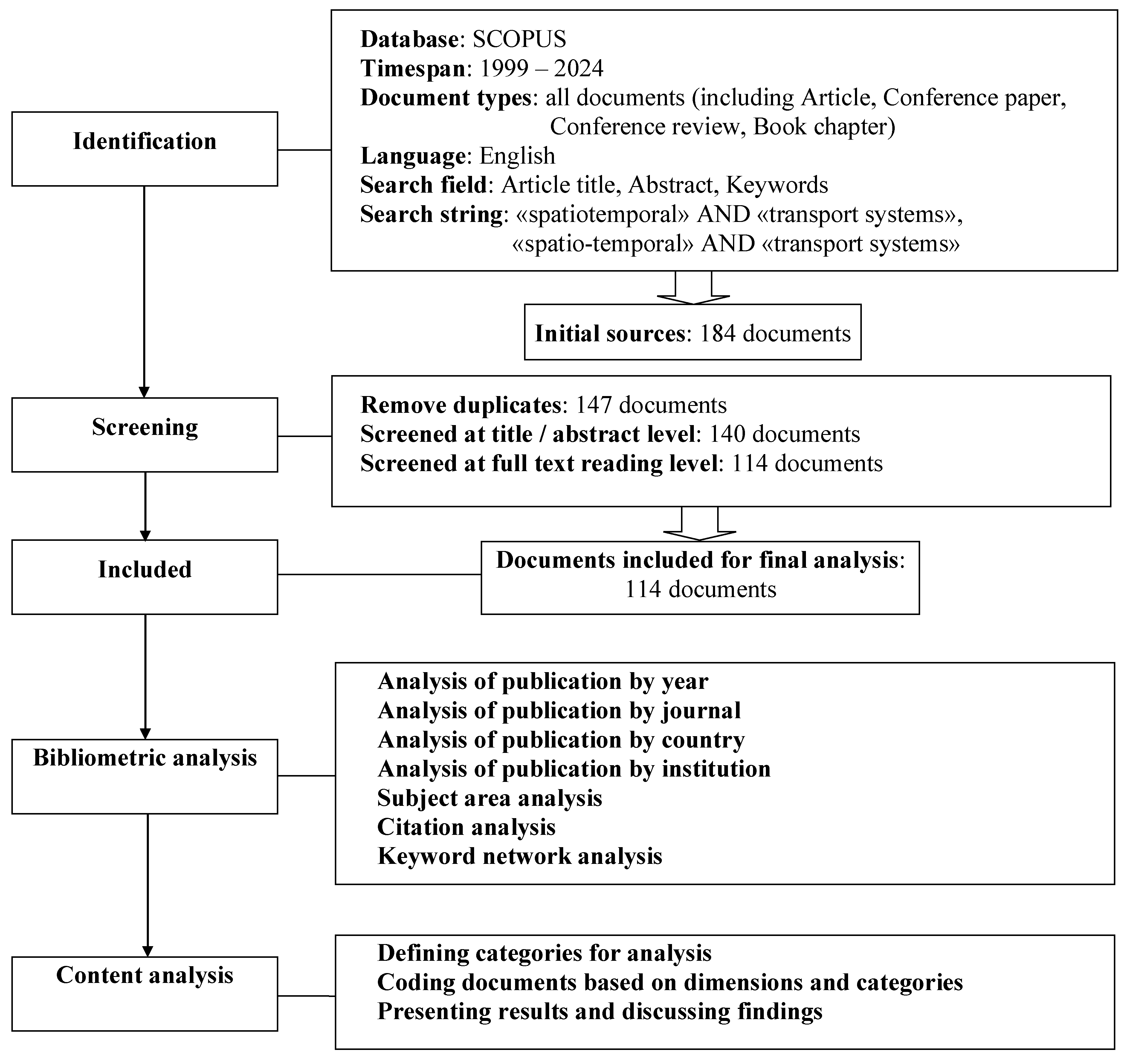
Figure 2.
Distribution of papers on the researched subject in the Scopus database from 1999 to 2024.
Figure 2.
Distribution of papers on the researched subject in the Scopus database from 1999 to 2024.
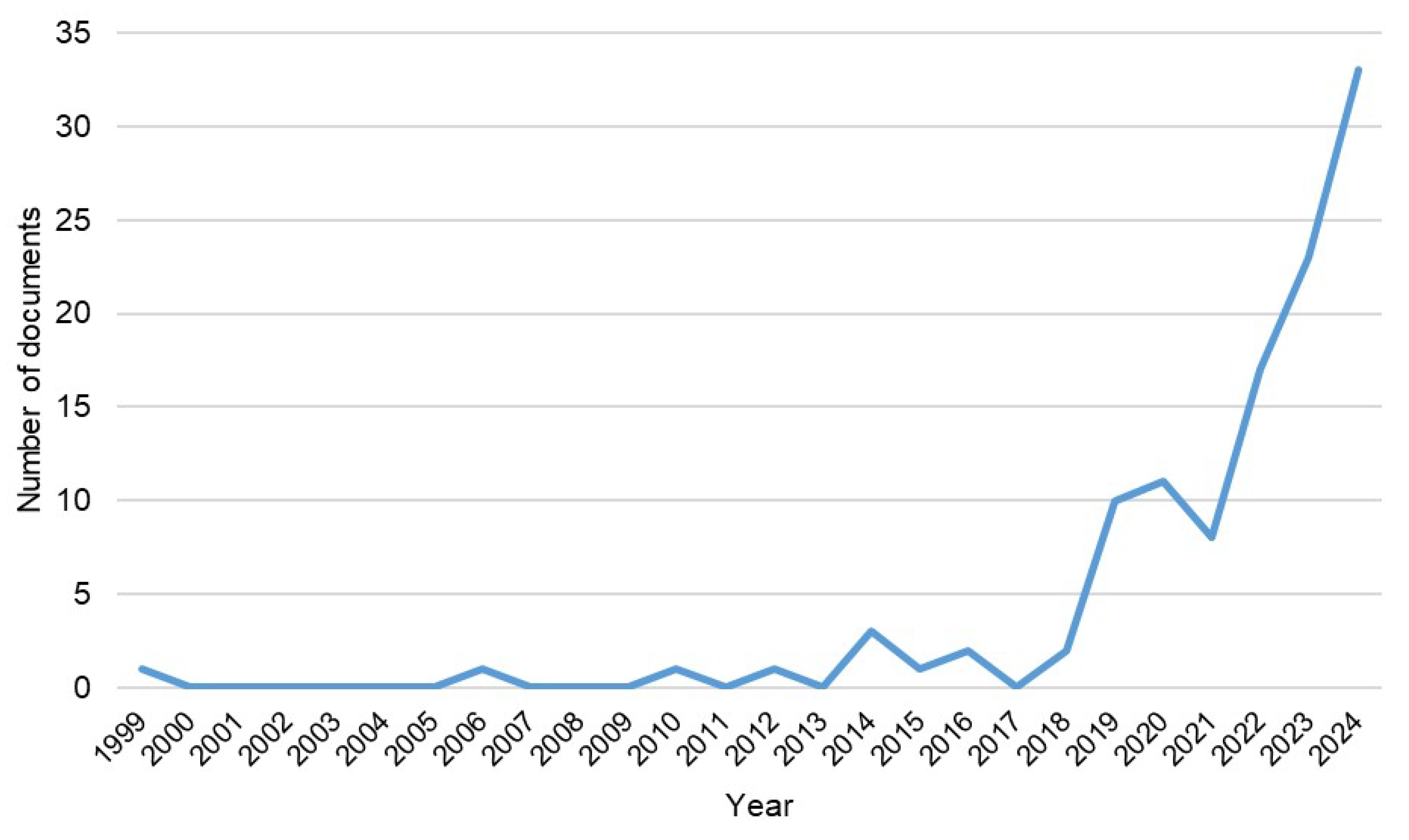
Figure 3.
Distribution of papers by type.
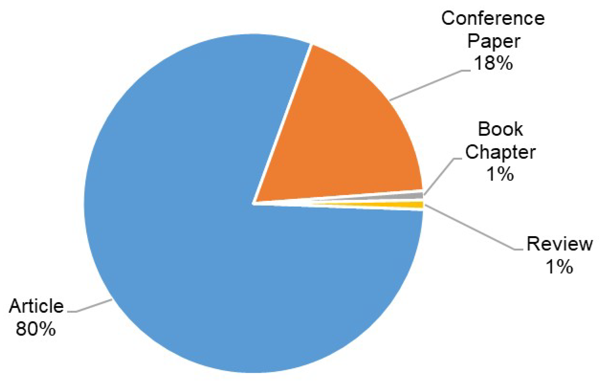
Figure 4.
Distribution of papers by journals.
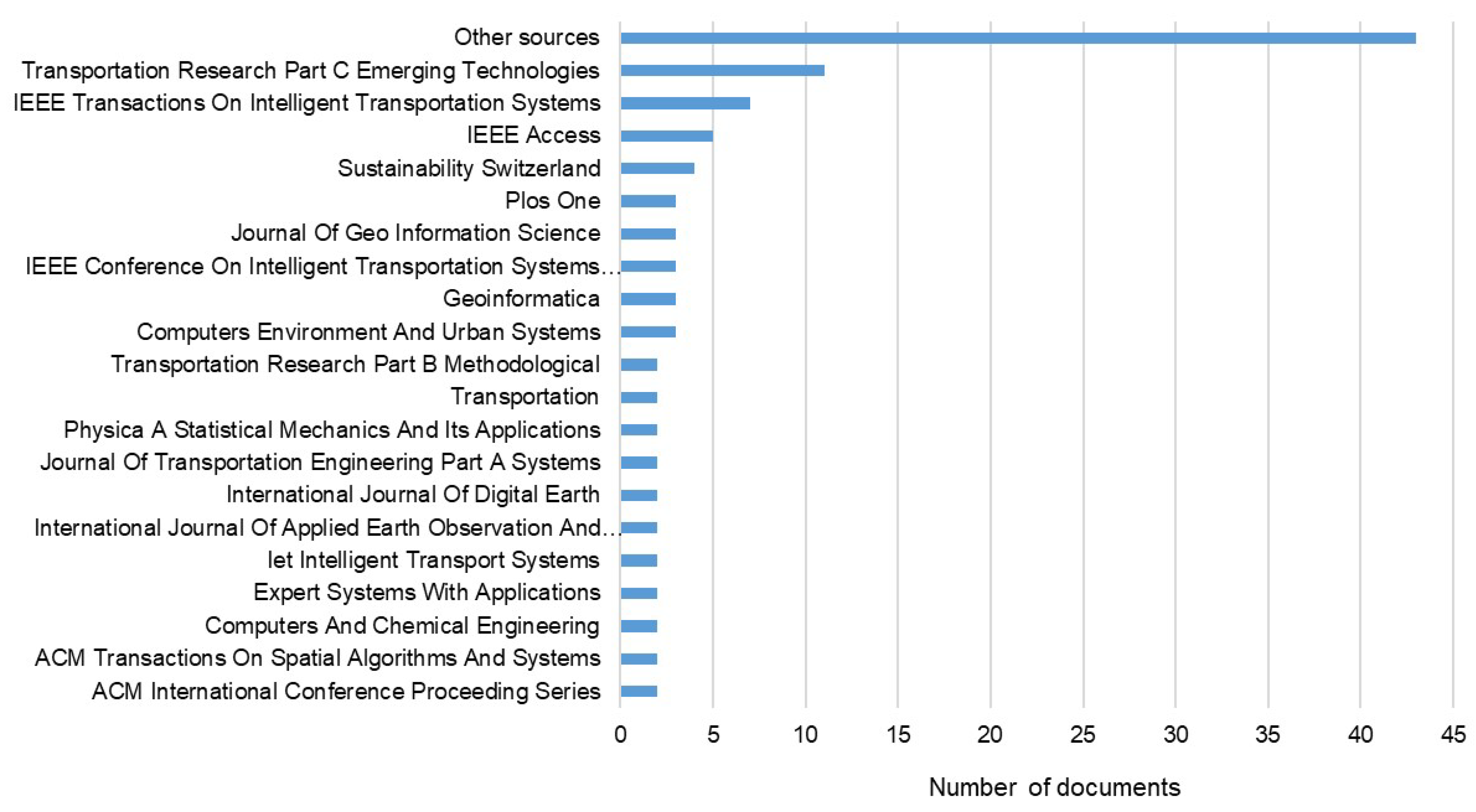
Figure 5.
Distribution of papers by fields of knowledge.
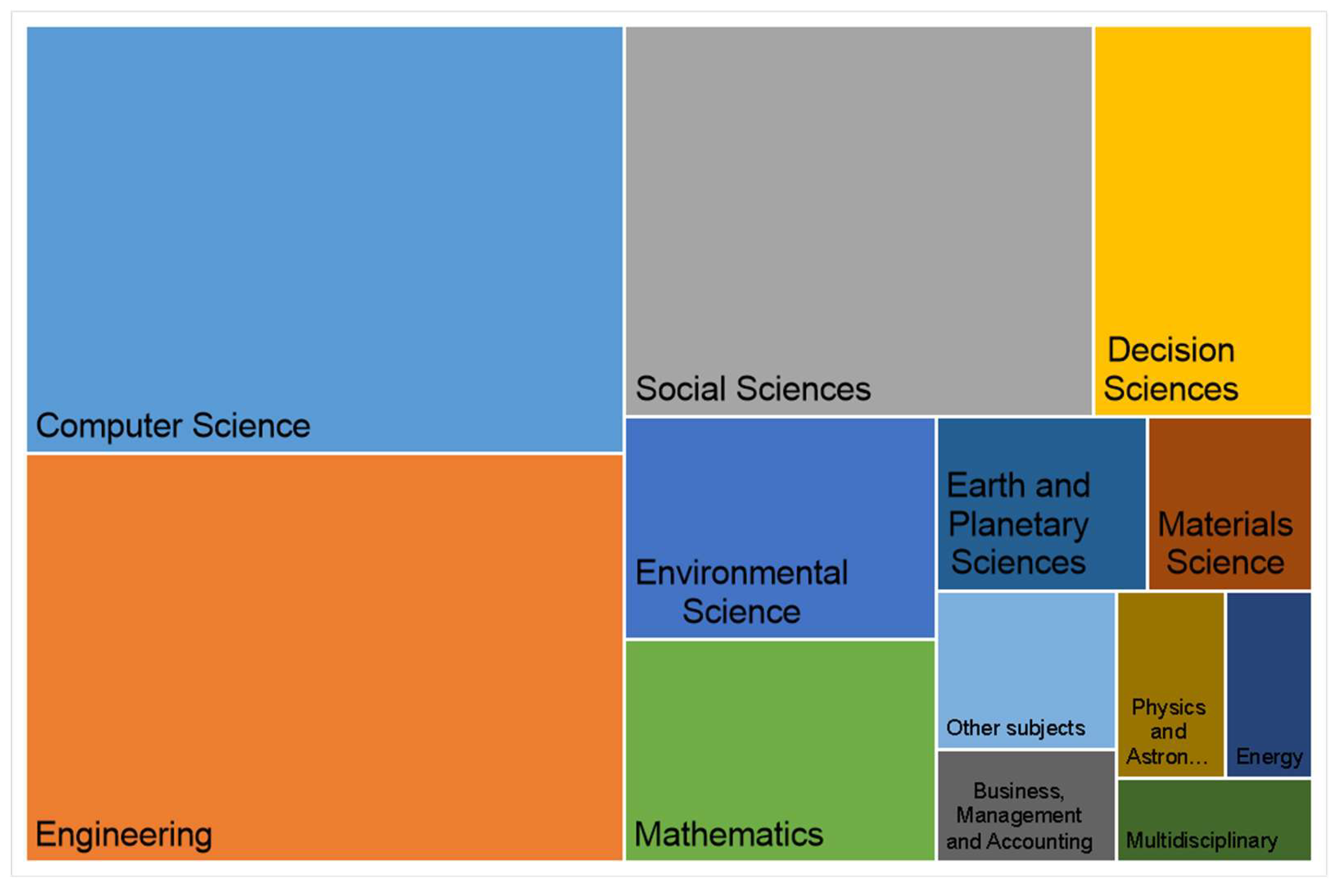
Figure 6.
Distribution of papers by country.
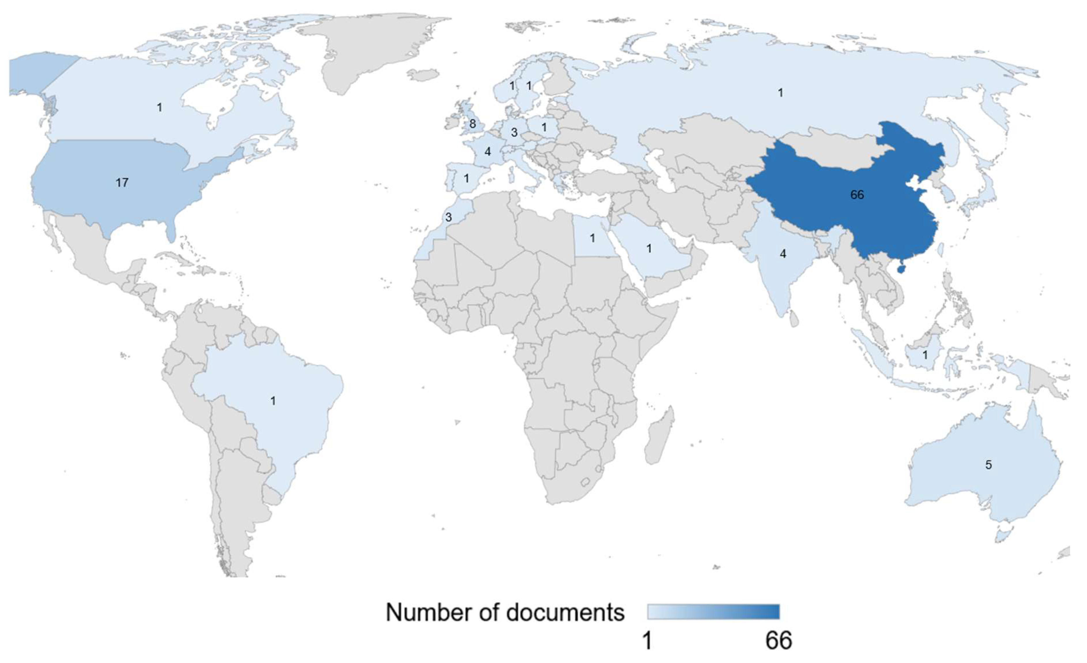
Figure 7.
Number of citations cumulatively by year.
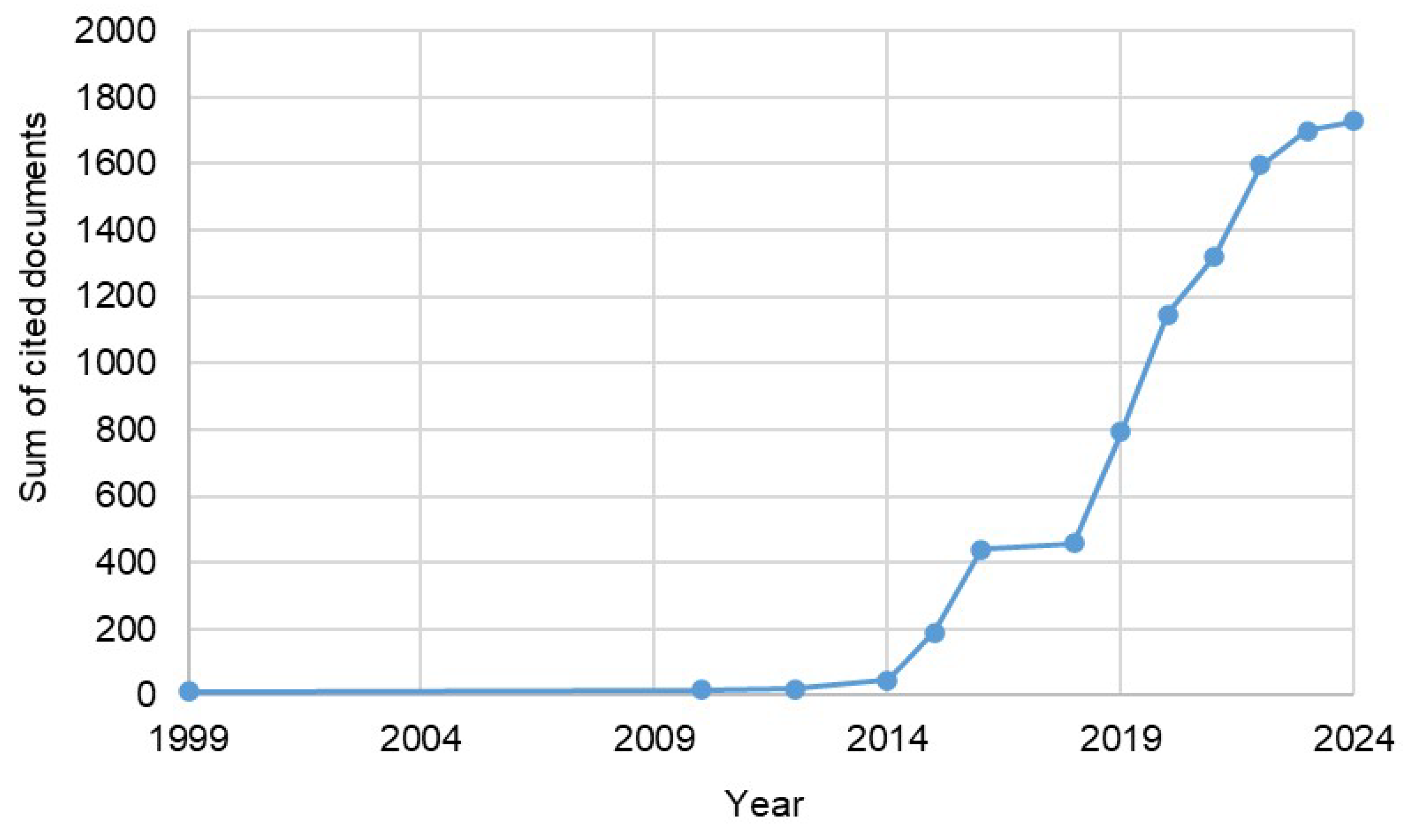
Figure 8.
Most frequently used keywords in papers published between 1999 and 2018.
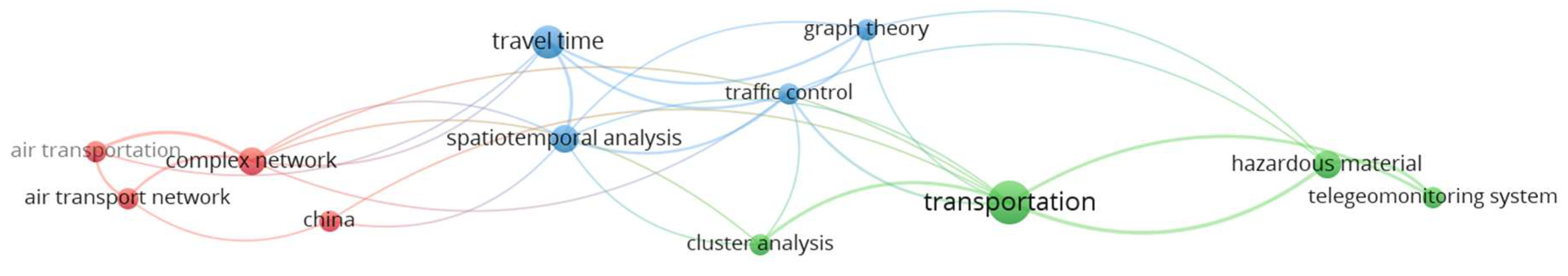
Figure 9.
Most frequently used keywords in papers published between 2019 and 2024.
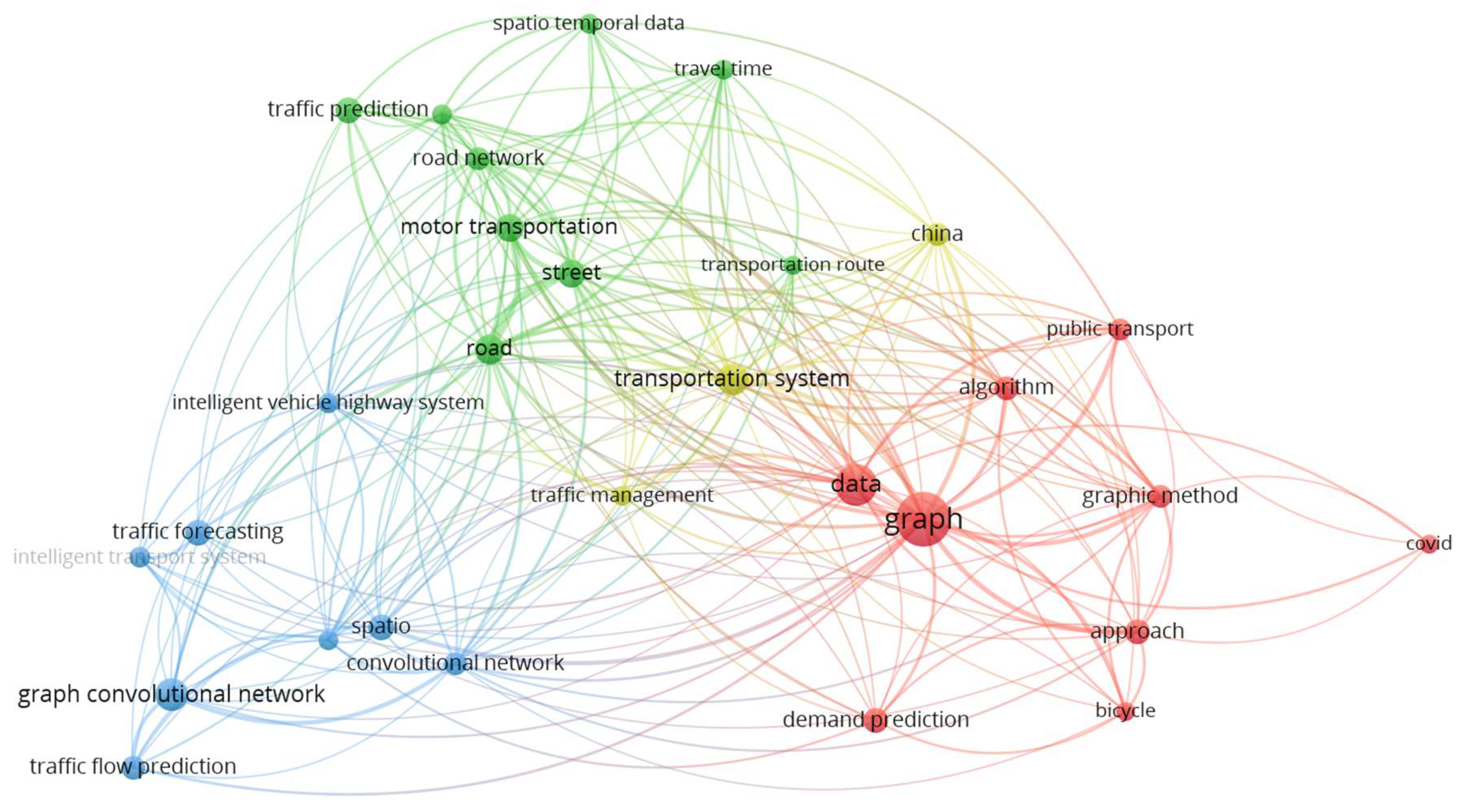

Table 1.
TOP-5 most cited publications.
| № | Title | Author(s) | Year | Number of citations | Reference |
|---|---|---|---|---|---|
| 1 | Clustering of heterogeneous networks with directional flows based on «Snake» similarities | Saeedmanesh, M., Geroliminis, N. | 2016 | 195 | [14] |
| 2 | Understanding spatiotemporal patterns of biking behavior by analyzing massive bike sharing data in Chicago | Zhou, X. | 2015 | 143 | [15] |
| 3 | A spatiotemporal and graph-based analysis of dockless bike sharing patterns to understand urban flows over the last mile | Yang, Y., Heppenstall, A., Turner, A., Comber, A. | 2019 | 119 | [16] |
| 4 | Spatial-temporal graph attention networks: A deep learning approach for traffic forecasting | Zhang, C., Yu, J.J.Q., Liu, Y. | 2019 | 114 | [17] |
| 5 | Urban ride-hailing demand prediction with multiple spatio-temporal information fusion network | Jin, G., Cui, Y., Zeng, L., (...), Feng, Y., Huang, J. | 2020 | 92 | [18] |
Table 2.
Distribution of papers by mode of transport and subject areas.
| № | Mode of transportation (Transport system) |
Subject areas | References |
|---|---|---|---|
| 1 | Road transport | Smart transportation | [19] |
| Urban built environment and traffic congestion Traffic forecasting congestion Control of traffic in urban networks |
[20] [21] [14,22] |
||
| The pick-up and drop-off locations in taxi Taxicab traffic control Taxi demand prediction |
[23] [24,25] [18,26] |
||
| Bus routes Bus systems Bus station Bus operation |
[27] [28] [29] [30] |
||
| Prediction of urban traffic | [31] | ||
| The automatic license plate recognition | [32,33,34] | ||
| Predicting occupancy of urban parking Designing mobile priority parking lots |
[35] [36] |
||
| Transportation networks with heterogeneous vehicular flow | [37] | ||
| Carriage of dangerous goods | [38] | ||
| 2 | Rail transport | Shaping the railroad network | [39] |
| Digital twin railway | [40,41] | ||
| Inter-urban container traffic flow | [42] | ||
| Mobility of urban rail transport passengers | [43] | ||
| Prediction of cascading delays in the railroad network | [44] | ||
| Prediction of transit flow in urban transportation systems Passenger flow forecast |
[45] [46] |
||
| Predicting the delay time of trains | [47] | ||
| 3 | Maritime transport | Cargo transportation on the maritime transportation network | [48] |
| Traffic density prediction | [49] | ||
| Traffic flow prediction for busy waterway segments | [50] | ||
| Autonomous ships | [51] | ||
| 4 | Air transport | Air transport network | [52] |
| Forecasting framework for en route airspace emissions | [53] | ||
| Passenger travels | [54] | ||
| Predicting airport delays | [55] | ||
| 5 | Urban land transport systems | Bike sharing systems | [15,16,56,57,58,59,60,61,62,63,64,65,66] |
| 6 | Underground transport | Metro systems | [67,68] |
| 7 | Multimodal transport systems | Mobility on public transport Clean Air Routing |
[69] [70] |
| Route in urban multimodal transport networks | [71,72,73] | ||
| Multimodal transport demand forecasting | [74,75] | ||
| Supply chain design The reliability of transport system Transportation of products in supply chains |
[76] [77] [78] |
||
| 8 | Intelligent transportation systems (ITC) | Urban traffic prediction Road traffic/road network data Vehicle trajectory Traffic speed prediction Urban traffic demand forecasting Regional-scale traffic framework Routing Modeling of road segments and intersections |
[79,80,81,82,83,84,85,86,87,88,89,90,91] [92] [93,94,95,96] [17,97] [98,99] [100] [101] |
| Traffic flow forecasting Forecasting passenger flows |
[102,103,104,105,106,107,108,109] [110,111,112] |
||
| Mobile conveying units Autonomous vehicles |
[113] [114,115] |
||
| Resilient urban transport network | [116] | ||
| Traffic signal control | [117] | ||
| Monitoring system for the transportation of hazardous goods | [118,119] | ||
| Order dispatching | [120] | ||
| Traffic monitoring system Vehicle type classification Interaction of vehicles with intelligent systems for transport automation |
[121] [122] [123] |
||
| Multi-traffic modes system | [124] | ||
| Multioperation transport processes | [125] |
Table 3.
Distribution of studies to used methods of transport systems spatiotemporal optimization.
| Method group | Method subgroup | Study objective | References |
|---|---|---|---|
| Mathematical programming | Linear Programming (LP) | Forecasting transportation flows | [76,112] |
| Forecasting demand and resource allocation | [120] | ||
| Route optimization | [71] | ||
| Multi-criteria Analysis | Routing with arrival window constraints | [126] | |
| Collision avoidance for autonomous vehicles | [51] | ||
| Optimizing bike sharing systems in urban areas | [63] | ||
| Dynamic Programming | Optimization of urban land use system structure based on time-distance accessibility criteria | [28] | |
| Predicting railroad infrastructure development | [39] | ||
| Predicting train delay times | [47] | ||
| Graph theory | Simple Graphs | Forecasting transportation flows | [19,91] |
| Hybrid parking allocation | [36] | ||
| Bike sharing | [16] | ||
| Optimal route for health (clean route) | [70] | ||
| Optimization of parameters of intra-city container railway hubs | [42] | ||
| Dynamic Graphs | Identification of bus routes and urban hotspot | [23,27] | |
| Clustering of traffic of different vehicles | [14] | ||
| Clustering of demand-responsive bicycle stations | [65] | ||
| Identification of urban traffic flow patterns | [96] | ||
| Spatiotemporal Graph | The shortest possible routes for mobile conveyors | [113] | |
| Optimized product distribution | [78] | ||
| Biological Graphs | Transportation control to prevent spoilage of perishable goods | [125] | |
| Heuristic methods | Heuristic Strategies | Analysis of cyclists' behavior | [15] |
| Analysis of changes in cyclist behavior during COVID-19 | [62] | ||
| Adjusting the route in case of congestion | [127] | ||
| Vehicle type classifications | [122] | ||
| Feed Forward Neural Networks (FFGN) | Traffic flow forecasting | [21] | |
| Travel time reduction | [114] | ||
| Forecasting multimodal transportation demand | [75] | ||
| Converged Neural Networks (CNN) | Automatically identify potential congestion points in cities | [20] | |
| Forecasting transit flows | [45] | ||
| Recover missing traffic data | [92] | ||
| Subway traffic forecasting | [68] | ||
| Forecasting demand for cab services | [99] | ||
| Traffic density forecasting | [49] | ||
| Traffic flow forecasting | [108] | ||
| Graph Convolutional Neural Networks (GCN) | Traffic flow forecasting | [85,87] | |
| Predicting the spatial distribution of free shared bicycles | [61] | ||
| Travel time estimation | [94] | ||
| Predicting delays | [55] | ||
| Forecasting demand for cab services | [18] | ||
| Graph Neural Networks (GNN) | Traffic flow forecasting | [31,50,81,82,84,88,102] | |
| Transportation risk assessment | [77] | ||
| Cyclist flow forecasting | [57,58,59] | ||
| Forecasting vehicle positioning | [93] | ||
| Forecasting vehicle queues | [86] | ||
| Predicting cascading delays in the rail network | [44] | ||
| Identification of large-scale traffic congestion | [115] | ||
| Multimodal route planning | [73] | ||
| Hybrid Neural Networks | Traffic flow forecasting | [33,73,79,89,105] | |
| Air pollution forecasting | [53] | ||
| Parking lot occupancy prediction | [35] | ||
| Transportation resiliency analysis for extreme weather events | [116] | ||
| Route optimization | [104] | ||
| Transport demand forecasting | [60], [74] | ||
| Complex Network Theory Methods | Air pollution forecasting for air transportation | [52] | |
| Traffic flow forecasting | [109] | ||
| Passenger flow forecasting | [110] | ||
| Standardization of flight times in Europe | [54] | ||
| Transportation demand forecasting (Cabs) | [26,98] | ||
| Traffic management | [22] | ||
| Identify bottlenecks in the metro system | [67] | ||
| Machine Learning | Rail project management | [40] | |
| Real-time traffic monitoring | [24,121] | ||
| Passenger flow forecasting | [29,111] | ||
| Traffic flow forecasting | [100,124] | ||
| Data representation method in digital twin in railway transportation | [41] | ||
| Bus distribution planning | [30] | ||
| Public transport passenger mobility forecasting | [43] | ||
| Distributed spatiotemporal network of hazardous materials data repositories | [38] | ||
| Multimodal route forecasting | [73] | ||
| Vehicle and transportation demand forecasting | [25,64] | ||
| Traffic flow identification | [34] | ||
| Spatiotemporal patterns in maritime freight transportation networks | [48] | ||
| Monitoring hazardous materials' transportation. | [118,119] | ||
| Resource allocation | [66] | ||
| Deep Learning Methods | Trip planning | [69] | |
| Traffic flow forecasting | [37,80,90,107] | ||
| Traffic trajectory data retrieval, real-time vehicle trajectory imputation | [32,95] | ||
| Forecasting demand for multiple modes of transportation | [56] | ||
| Travel time estimation | [101] | ||
| Automating vehicle interaction | [123] | ||
| Traffic speed prediction | [17] | ||
| Genetic Algorithms | Traffic light control | [117] |
Disclaimer/Publisher’s Note: The statements, opinions and data contained in all publications are solely those of the individual author(s) and contributor(s) and not of MDPI and/or the editor(s). MDPI and/or the editor(s) disclaim responsibility for any injury to people or property resulting from any ideas, methods, instructions or products referred to in the content. |
© 2024 by the authors. Licensee MDPI, Basel, Switzerland. This article is an open access article distributed under the terms and conditions of the Creative Commons Attribution (CC BY) license (http://creativecommons.org/licenses/by/4.0/).
Copyright: This open access article is published under a Creative Commons CC BY 4.0 license, which permit the free download, distribution, and reuse, provided that the author and preprint are cited in any reuse.


