
Submitted:
02 April 2025
Posted:
03 April 2025
You are already at the latest version
Abstract
This paper presents an investigation based on an agreement between the Polytechnic University of Bari and the Archaeological Park of Egnazia. The objectives of this collaboration are to define solutions for enhancing the accessibility of the archaeological park, including a protection and a covering system for the entrance to the ancient cryptoporticus and a removable, repositionable fencing system for excavation areas, integrated with lighting and information systems. The methodology involves framing the contemporary relationship between design and archaeology by analyzing existing theoretical literature and identifying recent case studies in Italy and broad. In a second phase, the paper will focus on the Archaeological Park of Egnazia, considering both as a part of a broader landscape system and as a specific site for experimentation. The findings contribute to the development of a methodological framework that categorizes interventions based on the key principles of temporariness, flexibility, adaptability, and sustainability. The ultimate goal is to define design strategies for archaeological parks that address the challenge of integrating visitor accessibility with the requirements of excavation, protection and conservation.
Keywords:
product design
; ephemeral design
; design for landscape
; archaeological parks
; egnazia
; apulia
1. Introduction
Current approaches to interventions in archaeological sites tend to shift away from the concepts of transformation and renewal, moving closer to the idea of fostering a physical and social dialogue between ruins, context, and people. Paraphrasing Jean Baudrillard's reflections, an archaeological site, together with contemporary additions, defines a system of elements characterized by physical temporariness, social dynamism, and cultural changeability [9]. This is not a static situation, but rather a condition in which new additions can create the conditions for activating social and cultural processes, rather than merely inviting use and showcasing how a space can be used, with characteristics of affordance. Therefore, archaeological sites are increasingly seen as public spaces, both for their cultural heritage value and for their territorial identity [6,7,16,19,20].
Although the primary needs of archaeological sites focus on their accessibility and, secondarily, their ability to ensure the co-presence of visitors, scholars, and specialists, and despite the fact that protection approaches today extend to their relationship with the landscape and territorial context, the issue of space delimitation remains pressing, both for safety and protection reasons [1,29]. However, what is actually happening is that new interventions are increasingly conceived in terms of sustainability, flexibility, and integration, as well as in terms of expandability, both socially, disciplinarily, and formally [5,8]. Specifically, this means that once a clear necessity is identified, each intervention on ruins is required to be reversible and adaptable to future needs, while also reflecting an expansion of social involvement, multidisciplinary dialogue, and the physical extension of excavation areas. Consequently, if the new frontiers of interventions in archaeological sites are oriented towards innovative forms of protection, use, and management, micro-actions or zero-volume architectures seem to be preferred because they are more sustainable and flexible than large-scale transformations, at least in terms of the dialogical relationships between people and places, and the narrative dimension of the cultural context [4,24,32].
Thus, the discipline of product design is asked to expand its areas of application, its interaction strategies with all involved parties, including end-users, and its context of intervention, no longer limited to the ruins and their accessibility, but extending to the entire landscape and cultural context [15,27].
In the intersection of heritage, history, and memory, the digital dimension also assumes significant importance: immateriality, virtuality, and interactivity become fundamental aspects of new interventions, both to reduce invasiveness and enhance user engagement [13]. Although this is more common in museography, even in archaeological parks, the use of digital technology opens the door to innovative forms of experience: digital tools can define new ways of communicating and revealing archaeological contexts through new languages and unexpected perspectives, while simultaneously maintaining the transfer of historical knowledge in a condition of easy accessibility and proximity [24]. This doesn’t only involve 3D models, virtual reconstructions, or the relocation of artifacts; the potential, particularly semantic, narrative, and communicative, lies primarily in the ability to expand interaction strategies toward new perspectives of knowledge sharing, thereby establishing new relationships between ruins, landscapes, objects, and people in a more complex environment [28].
Ultimately, this approach is similar to the one described by Jean Piaget when he explains the relationship between the child and the mirror: initially, for the child, the mirror is nothing more than a virtual device that reproduces an image, but later, once the child acquires a higher level of knowledge, it becomes an element through which he can develop his own interpretation of the image itself. In the same way, the relationship between humans and heritage is virtual when it is purely contemplative but becomes real and cultural when a participatory and interpretative process is activated [25].
Therefore, in this dimension as well, product design as a discipline becomes a fundamental ally of archaeological heritage for its ability to reveal future scenarios, enable active interpretative approaches rather than passive contemplation, encourage human interaction, and foster collaborative processes between managers, scholars, specialists, and communities, while giving cultural meaning to digital solutions. Thus, the project’s complex and dynamic condition lies at the intersection of space/time and real/virtual, where interventions in archaeological heritage embody a holistic vision of knowledge, protection, and use of space [21,24].
2. Materials and Methods
2.1. Ephemeral Design for Archaeologicy: Case Studies and Approaches
Contemporary approaches to ephemeral design for archaeology can be categorized into two main groups: physical and digital, both with the primary goal of enhancing the on-site experience of ruins, following the principle of non-displacement of artifacts, objects, and ruins from their original context [26,28]. These categories are: physical objects and digital applications.
The first category includes temporary installations, such as the Strates project, designed by LNV Architectes in 2012 during the public open-air exhibition Art and Archaeology in Cugnaux (France). The project consists of a removable structure made of various horizontal wooden layers, symbolizing the interpretation of archaeological stratifications and, at the same time, representing different levels of knowledge that visitors can metaphorically reach by climbing on them. Furthermore, the installation provides visitors with new visual perspectives of the surrounding urban area, offering an original narrative experience (Figure 1).
Another example is the construction of three small temporary shelters in the archaeological park of Valle dei Templi (Agrigento, Italy). This intervention resulted from a collaboration between Politecnico di Milano, Università di Palermo, and the University of Tokyo, and was presented during the Architecture x Archaeological Sites event in 2013. The project introduces an innovative, modular, flexible, and adaptable protection system aimed at enhancing the public experience of the site. The shelters are experimental prototypes built using local materials and designed with parametric software and digital manufacturing techniques, created and assembled by faculty and students (under the scientific supervision of Kengo Kuma). The shelters aim to protect the ruins and excavation areas, with the ethical purpose of connecting the ruins to the landscape through a contemporary physical sign (Figure 2).
Within the physical dimension of approaches, another interpretation involves movable artifacts, which includes projects like the interventions at the archaeological park of Paquimé in Chihuahua (Mexico) in 2011. Here, PKMN Arquitectures, working with students from ISAD, experimented with the insertion of self-built, low-cost, recycled ephemeral elements that allow visitors to interact physically with the site in unconventional ways. These mobile elements include viewpoints, carts for people with restricted mobility, sun protection devices, small observation towers offering different views of the site, and portable museums with information about the archaeological site. All of these movable elements provide visitors with an active experience of the site, encouraging engagement rather than passive contemplation, and fostering both individual and social storytelling about the place (Figure 3).
A third interpretation is the creation of playgrounds in archaeological parks, such as the Bosco Raggomitolato in the Tuscolo Archaeological Park (Rome) by Atelier delle Verdure (2013). The ancient Roman city of Tusculum is an important archaeological site located within a large natural park. After several interventions to enhance the site (including information and wayfinding systems, benches, tables, and small reception buildings), a system of small and simple modular wooden elements with steel cords coated in polyamide was introduced. This intervention creates an innovative social use of the archaeological park, serving as a link between the ruins and natural elements (Figure 4).
The second category encompasses digital applications. One noteworthy example is the design experience at the Núcleo Arqueológico da Rua dos Correiros (NARC), an exhibition in the archaeological remains in Lisbon (2021). Here, the media, graphic, and exhibition designer Atelier Brücker applied animated illustrations directly onto the ruins and surrounding areas. These images, along with lights and sounds, can be individually activated, allowing visitors to access information piece by piece. This setup reveals the historical development of ancient Olisipo, from its Iberian-Punic roots through to the Roman, Visigothic, and Medieval periods, through digital solutions (Figure 5).
A different interpretation of the role of digital design involves the use of artificial light as a design material. An example is the intervention at the Temple of Serapis in Pozzuoli (Naples, Italy) by Filippo Cannata in 2018. This intervention introduced a new multi-level lighting system to the archaeological site, aiming to establish an innovative relationship between the forms of the ruins and visitor emotions. The objectives of this intervention include architectural readability, scenography, and historical narrative reconstruction. It also incorporates an interactive element, where each visitor, through his smartphone, can hear sounds as the ruins are illuminated in different colours according to their historical origin (Figure 6).
2.2. The Archaeologicak Park of Egnazia
The archaeological site of Egnazia is located along the Adriatic coast of Apulia, in southern Italy, between the cities of Monopoli (Bari) and Brindisi. Egnazia, whose name comes from Via Egnatia, the ancient road built by the Romans in the 2nd century BC to connect the Adriatic Sea with the Aegean and Black Seas, is the ancient Gnathia, a Messapian settlement whose history spans from the Bronze Age to the Middle Ages due to its commercial importance in connecting East and West. Today, it is one of the most important archaeological areas in the southeast of the Italian Peninsula [2,18] (Figure 7).
The first settlement dates back to the 16th century BC and continued into the Iron Age when the entire Apulian region was inhabited by the Iapyges. Around the end of the 6th century BC, Egnazia became known as a settlement of Messapia, corresponding to the current provinces of Brindisi and Lecce. From the 3rd century BC, with the Roman presence, the city underwent transformations in urban planning, and by the 1st century BC, it acquired the status of municipium, growing in importance thanks to its port and the Via Traiana. From the 6th century AD, the lower part of the city was gradually abandoned, and the settlement continued on the Acropolis until the 13th century [17].
Today, the archaeological site, where official excavations began in 1912 and continued from 1963 to 1971 and after 2001, is divided into five main areas: the acropolis, lower city, baths, cryptoporticus, and western necropolis. The acropolis, with its 7-meter-high defensive wall, occupies a small hill overlooking the sea, its shape adapting to the rugged coastline. The lower city (where a stretch of the Via Traiana, the Forum, and the Amphitheatre are still clearly visible) extends further inland to the south, beyond the current provincial road. The cryptoporticus and the western necropolis are located even further south, though they are not well connected to the main archaeological areas [12].
The value of Egnazia is not only historical and archaeological but also lies in its landscape context, as it is set in a unique natural environment. The ruins are integrated harmoniously with the landscape, which is why the site has been designated an “archaeological park” under the Italian Cultural Heritage and Landscape Code 42/2044. It is a protected area where, due to the presence of monumental structures, a space of particular value can be identified and defined as an open-air museum [32].
In 2024 and 2025, a study on the settlement was conducted by the Department of Architecture, Construction, and Design of the Polytechnic of Bari, in collaboration with the Archaeological Park of Egnazia. The study resulted in multidisciplinary academic research and the activation of a master’s degree laboratory. Faculty, researchers, and students, in collaboration with managers, administrators, and archaeologists, explored how to enhance protection, use, and knowledge of certain areas of the archaeological site, addressing the real needs expressed by the museum management. Specifically, the research focused on the cryptoporticus and new excavation areas not yet included in the visitor routes, with the aim of developing non-invasive design solutions to improve accessibility and protection while preserving the cultural and educational value of the ruins and rediscovering their authenticity.
The first phase of the investigation, of which this article is a part, consisted of a literature review, focusing on both the historical dimension and contemporary approaches to interventions in archaeological sites. Subsequently, background research was conducted to collect information from site managers and visitors through interviews (unstructured, semi-structured, and structured), questionnaires, and surveys to better understand the needs and requirements of all involved parties. These were divided into archetypal user groups (personas) and used to assess the current state of the site from a cultural and social perspective.
The second phase involved site exploration, including shadowing activities to analyse how visitors move through the archaeological park and how archaeologists work in the excavation areas. The exploration was carried out through several site inspections, conversations with professionals, observation of various uses of the space, and analysis of the archaeological context, both in terms of its morphology and the condition of the ruins and the natural environment (Figure 8).
The conclusions of this phase, which form the foundation for the design approaches and proposals described in the following section, include the following short guidelines:
- The design proposals must reflect historical stratifications, enhancing the readability of lesser-known parts of the archaeological areas.
- The design proposals must achieve the dual objective of protecting the ruins and enhancing the archaeological site from both a cultural and social perspective.
- The design proposals must be functional and respectful of the archaeological context and natural environment.
3. Results and Discussion
The research referenced in this article has provided an opportunity to delve deeper into design issues by exploring new approaches to the enhancement of archaeological sites. In this context, the discipline of design, in its temporary nature, plays a crucial role in contributing to the creation of a methodological framework that facilitates the improvement of relationships between people, place, and the natural landscape. This framework aims to be more feasible and sustainable compared to permanent morphological transformations [14].
From a methodological perspective, the research has sought to define an approach that combines different needs and requirements, depending on the various scenarios the archaeological park may experience over time. This means that the elements with which design actions must engage are dynamic, both diachronic and synchronic. Furthermore, the site has been interpreted as a system of objects, environment, and forms, where the first (ruins, findings, natural elements, existing furniture, new insertions, etc.) are seen as dynamic elements involved in various processes and life cycles (visits, studies, research, temporary events, archaeological excavations, etc.). The second are reactive, evolving, changing entities, while the third are flexible presences capable of activating new forms of space use.
This theoretical framework has been translated into an attitude of awareness, which has allowed us to approach interconnection as a key concept for plausible design proposals, along with flexibility, temporariness, and changeability. These are essential strategies to ensure modifications and adaptations to any new needs and requirements that may arise in the near future.
Therefore, the reflections presented introduce some specific actions developed for the archaeological park of Egnazia, with the ultimate goal of integrating visitor accessibility with the demands of the excavation. Specifically, these actions include: protecting the entrance to the cryptoporticus and defining a new fencing system to delimit the excavation areas.
3.1. A Shelter for the Cryptoporticus’ Entrance
The cryptoporticus is an underground vaulted structure built during the time of Augustus, occupying an almost rectangular area located to the south of the archaeological site, along Via Minucia, an ancient road perpendicular to Via Traiana (Figure 9). The structure consists of a vaulted corridor that runs along the perimeter of this rectangle, with an open entrance located at the southwest corner. It was likely part of a larger building that had a Doric portico above it, with a public building in the center (possibly a sanctuary), while the cryptoporticus itself served as a structural foundation and, at the same time, a public rainwater tank or (less likely) a grain storage space (oreum).
The primary requirements that emerged from discussions with museum managers and archaeologists relate to the need to cover and protect access to the cryptoporticus, redesigning its ground connection, which is currently formed by a 30-centimeter-high wall built in recent times, separated from the original structure by the insertion of brick fragments. Additionally, there was a desire to design a cover system that could be easily assembled and disassembled, minimally invasive, removable, with a low aesthetic impact that would not compromise the readability of the ruins.
In general, from a morphological point of view, according to Franco Minissi, a shelter for ruins can fall into three main functional and aesthetic categories: temporary roofs, permanent roofs with autonomous morphologies, and permanent roofs with morphologies that reproduce the ancient volumes [22]. This means that, in addition to the primary objective of protection, it is also necessary to help visitors better understand the original configuration of the ancient buildings and spaces, as well as clearly read the relationships between different archaeological elements. This does not necessarily mean a faithful reconstruction, but rather a contemporary interpretation of a new dialogue between ruins, people, and the landscape [10].
A second design challenge concerns the formal and constructive relationship between new insertions and historical walls. In this regard, a new protective structure can be placed following three possible positioning options in relation to the ruins: outside, inside, or aligned with the ancient walls.
In the first case, the new structure does not touch the ruins and encircles the perimeter, creating an enclosure that protects the historical walls and separates the ruins from the environment. A notable example is the famous project by Peter Zumthor, the Shelter for Roman Ruins in Chur (Switzerland, 1986), where a timber lamella construction surrounds and preserves the excavation, allowing only light and ventilation to enter, establishing a balance between the discontinuity of structural elements and the continuity of the enclosing surfaces.
In the second case, the new structure is placed inside the perimeter of the historical walls, leaving them visible from the outside and in direct contact with the ground. In interventions of this type, the structural elements are always linear and discontinuous, and the protection of the ruins is not provided by vertical surfaces, but rather by horizontal shelters that normally protrude from the pillars to cover the ruins. This solution can be chosen when there is a need to leave the perimeter free for further excavation or to maintain fluid connections between the ruins and their surroundings, especially when there is no clear configuration at the outer edges of the historical structure. An example of this is the deck over the Roman site of Molinete Park in Cartagena, Spain, by Aamann/Cánovas/Maruri (2011), where a morphologically complex structure supported by slender steel columns creates a continuous perception of the archaeological site, connecting it with a very diverse urban context.
In the third case, the new structure aligns with the historical walls, which occurs when the shelter takes on the role of an ancient building reconstruction device, or when the original walls have irregular geometry and the new structure uses them as a foundation. The archaeological musealization of Praça Nova do Castelo de São Jorge in Lisbon by Carrilho da Graça (2010) is an intervention that takes this approach, as it protects, reveals, and clarifies the site through the construction of a new form, whose load-bearing structure, seemingly “suspended” on the historical walls, rests directly on them, creating a contemporary reconfiguration of the 11th-century Muslim domestic structures.
At Egnazia, there is no need to be selective or exclusive about the landscape. On the contrary, the project is intended to ensure a visual interaction between the ruins and the landscape. However, considering that the perimeter walls contain a hole and a staircase, and it is dangerous to place structures outside due to the uncertain archaeological condition of the site, the best solution appears to be using the existing, non-original wall base as support for the new structure.
The main task of the project is to cover and protect the entrance to the cryptoporticus without compromising the readability of the ruins, while also creating a sign or an attractive element that makes the entrance recognizable within the large space surrounded by significant historical and natural surroundings. The structure is discreet but anti-mimetic, consisting of a shelter supported by slender rectangular-section steel pillars. Its stepped surface conceptually mirrors the staircase below that leads to the underground vaulted space. This construction aims to be a semiotic frame rather than a rhetorical reconstruction, with the goal of not revealing the space but creating a narrative dimension and connecting the cryptoporticus to other archaeological areas from which it is currently separated (Figure 10).
3.2. A Fencing System for the Excavation Areas
If we consider the archaeological site as a place, it becomes essential to investigate and define its boundaries. As Christian Norberg-Schulz reminds us, a place is always experienced as an interior, in contrast with the exterior that surrounds it [30]. Reflecting on the meaning of boundaries, understood as the study of the relationship between inclusion and exclusion of spaces, surfaces, materials, and forms, is crucial because the archaeological area is an integral part of the landscape. There is a natural horizontal limit between the archaeological areas and the landscape, a direct consequence of the altitude difference between the two levels, which in terms of accessibility presents a challenge to overcome. However, the boundary between the archaeological areas and the surrounding landscape is not only physical but also temporal. The issue here is identifying or redefining layers of time and placing them in relation to the present. As Michel Conan argues, space is nothing but compressed time, within which landscape can make the archaeological imagery of contemporary societies visible [11]. Similarly, according to Bernard Lassus, landscape is a stratification of different historical layers, chronologically superimposed and excavated, to be reinterpreted with the patience and precision of an archaeologist [23]. Defining the boundary of the archaeological areas thus means identifying the boundary between the present and the memory. As Alessandro Anselmi notes, the enclosure must be crossed to enter the territory of time, and consequently, its symbolic function must be integrated with the function of penetration [3].
The issue of the boundary between archaeology and landscape does not always require the search for its precise contours. Most recent experiences demonstrate an approach that dissolves these boundaries in favor of a new principle: the aesthetic-functional integration of the parts. This reflects a change in how we interpret the ancient/modern relationship: initially, ruins were objects of conservation, and the boundary between what was preserved and what was not was defined by the excavation. In a later phase, ruins began to integrate with their surroundings, blending with territorial transformation dynamics. In a third phase, the ruin-landscape relationship tends to dissolve, taking on a "diffusive" and "diachronic" character, in which the body of information, data, and meanings increasingly refers to the broader territorial system, rather than individual parts [31].
This approach replaces the idea of the archaeological site with the concept of archaeological space, relating it to landscape space within a unified public dimension. However, this idea of a unified public space raises several conflicts: first, the relationship between continuity and discontinuity, as the archaeological area is not public like the surrounding landscape but is intended for a specific audience; second, the relationship between the uses of the archaeological area and the functions of the parts of the landscape it relates to; and third, the strategies for dissolving the limits in relation to the archaeologists’ needs and the future use of space.
In this context, the design intervention regarding the creation of boundaries for the archaeological areas is expected to enhance the aesthetic meaning of the ruins, configuring its ethical dimension in relation to the landscape. It addresses at least two key issues.
The first issue concerns the relationship between the concepts of fracture and boundary: what are the requirements for the planimetric alignment with the site? Is there a correspondence between the original access routes and the new access points? The dialogic potential of the new intervention is linked to the soil’s character and the altitude difference between archaeological levels, realized through the concepts of edge, limit, and threshold in two specific conditions: one in which the ruins are integrated into the contemporary landscape after being uncovered, and another where the ruins remain underground, coexisting with multiple overlapping layers.
The second issue concerns the relationship between excavation and project, with both physical-spatial choices (affecting the landscape configuration) and programmatic-strategic choices (related to the future method and use of space). In this perspective, the project must engage with the context through the mechanism of selection: the choice of form and extent of excavation, the definition of the relationship between enclosures and boundaries of different historical and archaeological units.
In this theoretical framework, the design for a fencing/balustrade system for Egnazia addresses the theme of limits, both as a device for controlling form and as a dialogic element distinguishing and connecting traces from different historical periods. The boundary becomes a system whose edges define and describe various historical and archaeological elements, cutting them out in the landscape without creating hierarchies.
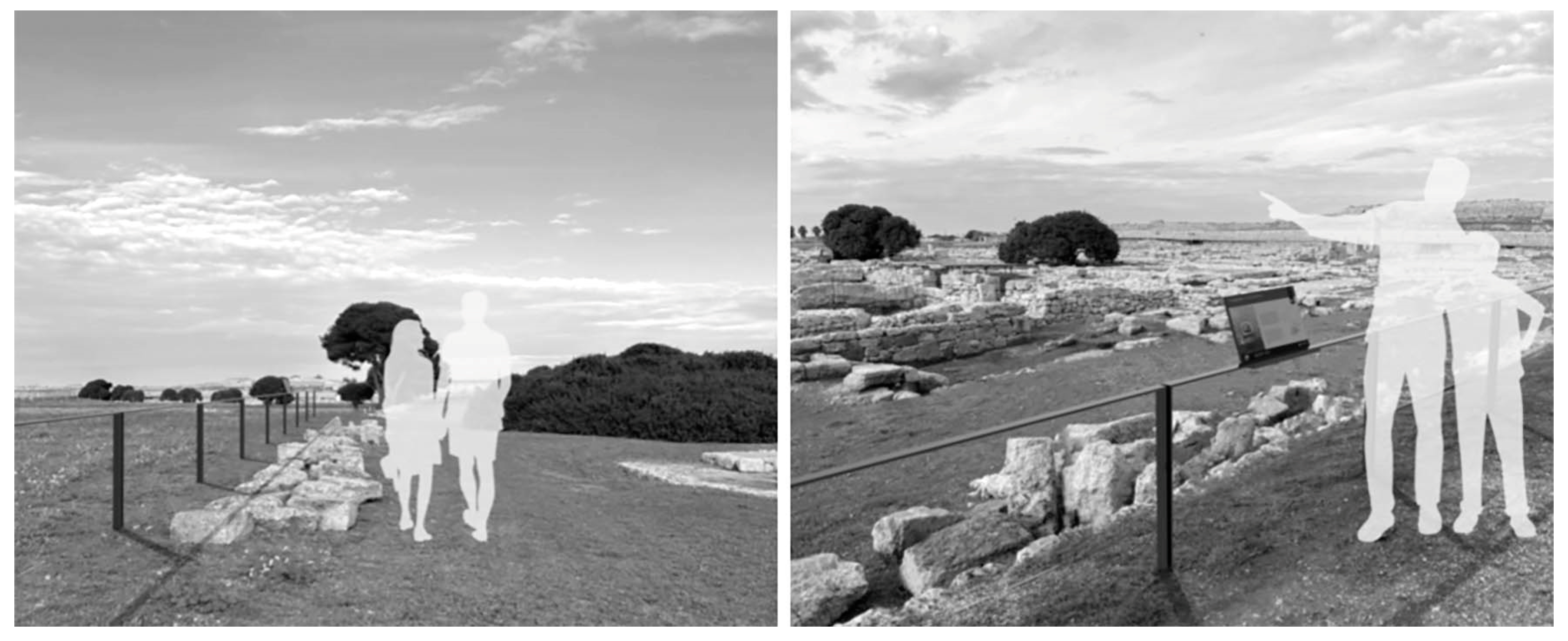
The need to redesign the fencing system arises from three main factors: first, the protection of visitors along paths; second, the delimitation of excavation areas; and third, the provision of a unified support for information and lighting systems.
The proposal consists of a flexible and modular steel balustrade system, equipped with an integrated lighting and information system, adaptable to the structure. Its concept is to create a boundary that marks restricted areas while still allowing visibility, ensuring double protection, minimizing visual impact, and avoiding the "sense of barrier."
The structure allows controlled access to different parts of the archaeological area and ensures proper readability of the site. It consists of a U-shaped element (dimensions 200x100 cm), with two vertical rectangular-section elements and one horizontal element, fixed in the ground through a removable system that allows easy dismantling and repositioning as necessary, depending on the expansion of excavation areas and/or changes in the archaeological layout. The horizontal element is equipped with panels containing information about the ruins (texts, images, Braille, QR codes, etc.) and LED lighting (Figure 11).
4. Conclusions
In both design experiments—the shelter for the cryptoporticus and the fencing system—there is a strong focus on the relationship between the inside and the outside. This theme, always crucial in interventions on existing contexts, becomes even more fundamental in archaeological areas. In fact, the inside/outside dichotomy takes on significance not only in physical and symbolic dimensions but also in terms of visual and spatial approaches to the site.
From this perspective, the design experiments aim to work with the idea of mediation, enabling a sort of cultural ritual in the approach to knowledge and facilitating the discovery of hidden aspects of the site in its dual dimensions of time and space. In other words, these design experiments provide a gradual immersion into the complexity of the archaeological site, defining different levels of “contact” and interaction with the ruins and landscape (observation, exploration, understanding, access to knowledge, etc.), while also encouraging visitors to be active participants in enhancing the social and cultural context of their experience.
In the case of Egnazia, both the shelter and the fencing system are not barriers or limits but “dialogical revealing devices”—bridges that connect the time of the original constructions with the time of excavation and discovery, as well as the time of use. They allow for integration rather than separation, accessibility rather than closure, and permeability and interaction rather than physical barriers.
The studies and experiences developed in the Archaeological Park of Egnazia have demonstrated that interventions in archaeological sites are evolving towards a more dynamic and participatory approach that balances preservation with contemporary social and cultural engagement. Moving away from rigid, large-scale transformations, modern strategies prioritize sustainability, flexibility, and digital integration to enhance user experience and accessibility. On one hand, the interdisciplinary nature of these interventions highlights the role of product design and digital tools in fostering deeper connections between ruins, landscapes, and people. On the other hand, this approach ultimately redefines archaeological sites as living cultural spaces, where historical narratives are not just preserved but actively reinterpreted and shared, ensuring their relevance for future generations.
Funding
This research received no external funding.
Acknowledgments
For the writing of this article, the author likes to thank Dr. Fabio Galeandro, Director of the Archaeological Park of Egnazia, and Prof. Gianluca Mastrocinque, Head of the archaeological excavations at Egnazia.
Conflicts of Interest
The author declares no conflicts of interest.
References
- Amendola, B.; Indrio, L. , Cazzella, R. I siti archeologici: un problema di musealizzazione all’aperto; Bonsignori Editore: Rome, Italy, 1988. [Google Scholar]
- Andreassi, G.; Cocchiaro, A. Necropoli d’Egnazia; Grafischena: Fasano, Italy, 2000. [Google Scholar]
- Anselmi, A. Inserimenti architettonici in ambiti archeologici e storico-monumentali. In Relazioni generali e relazioni ad invito del IV Convegno Nazionale Manutenzione e Recupero della Città Storica “L’inserzione del nuovo nel vecchio a trent’anni da Cesare Brandi; Centroni, A. Ed, Ed.; Gangemi Editore: Rome, Italy, 2001; pp. 81–86. [Google Scholar]
- Aymonino, A.; Mosco, V. Spazi pubblici contemporanei. Architettura a volume zero; Aracne: Milan, Italy, 2016. [Google Scholar]
- Bagnato, V.P. Architettura e rovina archeologica. Etica, estetica e semantica del paesaggio culturale; Aracne: Rome, Italy, 2017. [Google Scholar]
- Bagnato, V.P. Design and Cultural heritage: New Senses and Sensibilities of Archaeological Sites. In Development in Design Research and Practice II; Duarte, E., Di Roma, A., Eds, *!!! REPLACE !!!*, Eds.; Springer: Cham, Switzerland, 2023; pp. 15–26. [Google Scholar]
- Bagnato, V.P. Design, espacio público y patrimonio cultural: Una nueva perspectiva dialógica. Arquitectonics. Mind, Land, Society 2023, 34, 267–284. [Google Scholar]
- Bagnato, V.P.; Martinelli, M. Recycling Heritage Between Planning and Design Interventions. In Cultural Urban Heritage. Development, Learning and Landscape Strategies; Obad Scitaroci, M., Bojanic, B., Mrda, A. Eds, Eds.; Springer: Zurich, Switzerland, 2019; pp. 155–164. [Google Scholar]
- Baudrillard, J. The system of objects; Verso: New York, USA, 1996. [Google Scholar]
- Bellomo, M. Materiali e tecnologie per le coperture in aree archeologiche: una riflessione sull’argomento. In Tecniche edili tradizionali: contributi per la conoscenza e la conservazione del patrimonio archeologico; Marino, L; Pietramellara, C.; Nenci, C. Eds; Alinea, Florence, Italy 1999; pp. 63-64.
- Berque, A.; Conan, M. ; Donadieu, P; Lassus, B., Roger, A. Mouvance, Cinquante mots pour le paysage, Eds.; Editions de la Villette: Paris, France, 2001. [Google Scholar]
- Cassano, R.; Chelotti, M.; Mastrocinque, G. Paesaggi urbani della Puglia in Età Romana. Dalla società indigena alle comunità tardoantiche; EdiPuglia: Bari, Italy, 2019. [Google Scholar]
- Celaschi, F; Trocchianesi, R. Design e beni culturali. La cultura del progetto nella valorizzazione del bene culturale; Polidesign: Milan, Italy, 2004. [Google Scholar]
- Chandran, R.; Chon, H. Redefining Heritage and Cultural Preservation Through Design: A Framework for Experience Design. In With Design: Reinventing Design Modes; Bruyns, G., Wei, E. Eds; Springer, Singapore, 2022; pp. 1246-1264.
- Conti, C.; Garofalo, I. AA_archeologia accessibile. La valorizzazione del patrimonio culturale attraverso l’accessibilità ambientale. TECHNE, 2014, 7, 40–48. [Google Scholar]
- Daverio, P.; Trapani, V. Il Design dei Beni Culturali. Crisi Territorio Identità; Rizzoli: Milan, Italy, 2013. [Google Scholar]
- De Juliis, E.M. Archeologia in Puglia; Adda Editore: Bari, Italy, 2004. [Google Scholar]
- Donvito, A. Egnazia: dalle origini alla riscoperta archeologica; Schena Editore: Fasano, Italy, 1994. [Google Scholar]
- Follesa, S. Design & Identità. Progettare per i luoghi; FrancoAngeli: Milan, Italy, 2010. [Google Scholar]
- Irace, F. Design & cultural heritage. Progetto e memoria del temporaneo; Mondadori Electa: Milan, Italy, 2014. [Google Scholar]
- Irace, F. Design & cultural heritage. Immateriale Virtuale Interattivo; Mondadori Electa: Milan, Italy, 2014. [Google Scholar]
- Laurenti, M.C. Le coperture delle aree archeologiche. Museo aperto; Gangemi Editore: Rome, Italy, 2012. [Google Scholar]
- Lassus, B. The landscape approaches. University of Pennsylvania: Philadelphia, USA, 1998.
- Lupo, E. Design and innovation for the cultural heritage. Phygital connections for a heritage of proximity. Agathon 2021, 10, 186–199. [Google Scholar]
- Maldonado, T. Memoria e conoscenza; Feltrinelli Editore: Rome, Italy, 2005. [Google Scholar]
- Manacorda, D. Archeologia tra ricerca tutela e valorizzazione. Il capitale culturale. Studies on the Value of Cultural Heritage 2010, 1, 131–141. [Google Scholar]
- Mussinelli, E. Valorizzare I Beni archeologici tra Ambiente e Paesaggio. Agathòn 2015, 75-80.
- Nappi, M.L.; Laudante, E.; Buono, M. Design and Archaeology for the Communication of Tangible and Intangible Content Between Real and Digital. Diid 2024, 83, 120–129. [Google Scholar] [CrossRef]
- Nicolini, E. Accessibility Performance in Archaeological Sites. Criteria for Evaluation and Enhancement. In Accessibility in Architectural heritage. Approaches and experiences between technology and restoration; Germanà, M.L.; Prescia, R. Eds; Anteferma, Conegliano (Italy), 2021; 64-73.
- Norberg-Schulz, C. Existence, space and architecture. Praeger Publisher: London, UK, 1974.
- Tozzini, S. Tra azione museologica e azione programmatica: sinergie da inseguire nel progetto paesaggistico per i parchi archeologici. In Paesaggi. Didattica, ricerche e progetti; Ferrara, G.; Rizzo, G., Zoppi, M. Eds; Firenze University Press, Florence, Italy, 2007; pp. 291-302.
- Trocchianesi, R. Design e narrazioni per il patrimonio culturale; Maggioli: Rimini, Italy, 2014. [Google Scholar]
- Volpe, G. Passeggiate archeologiche. Venti proposte per conoscere siti e storie della Puglia; EdiPuglia: Bari, Italy, 2021. [Google Scholar]
Figure 1.
LNV Architectes, STRATES, Cugnaux, France, 2012 (Courtesy of LNV Architectes).
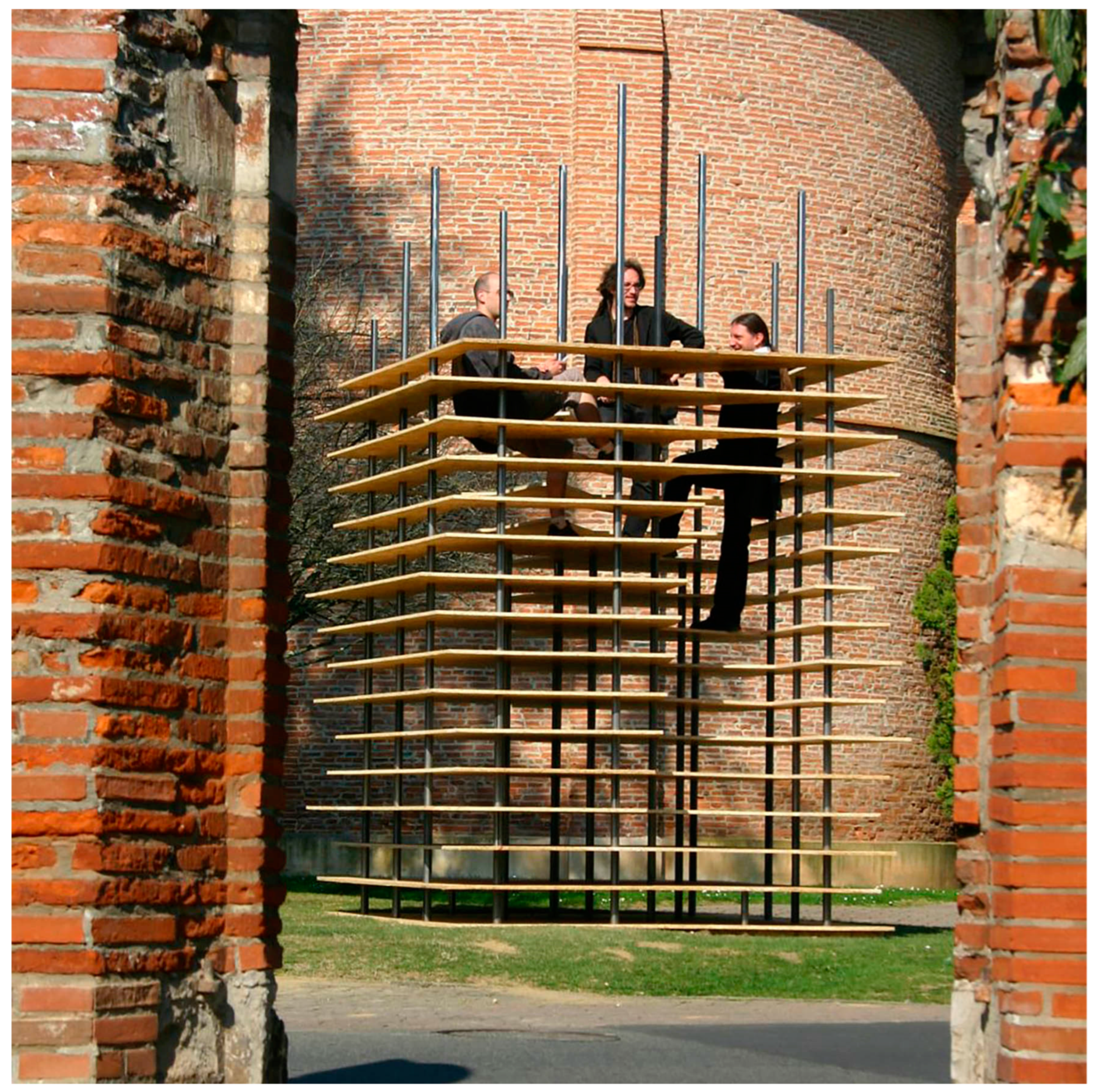
Figure 2.
Politecnico di Milano, Università di Palermo, University of Tokyo, Molecular Shelter, Agrigento, Italy, 2013 (Source: domusweb.it).
Figure 2.
Politecnico di Milano, Università di Palermo, University of Tokyo, Molecular Shelter, Agrigento, Italy, 2013 (Source: domusweb.it).
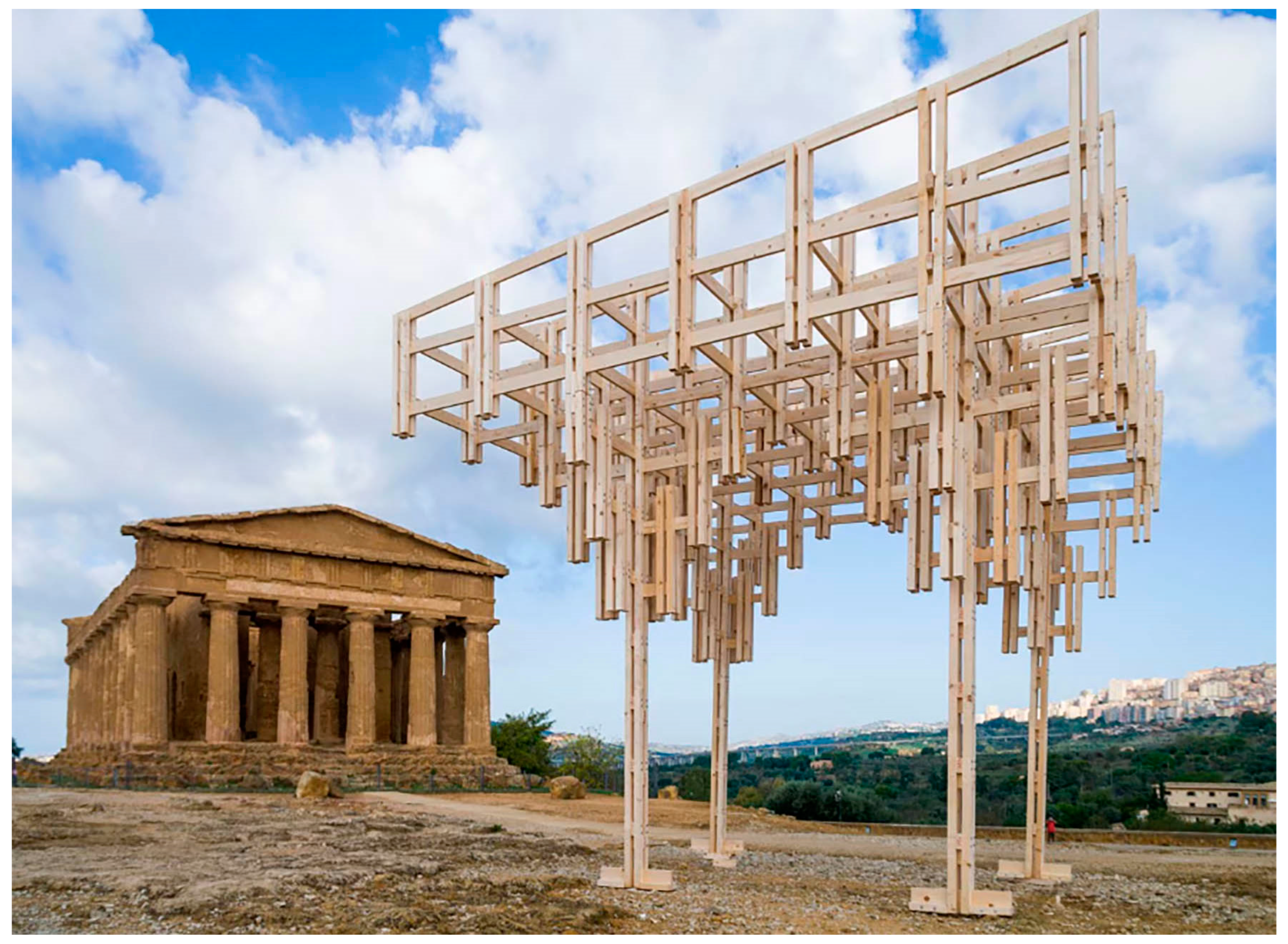
Figure 3.
PKMN Architectures, Rojo Paquimé, Chihuahua, Mexico, 2011 (Courtesy of PKMN Architectures).
Figure 3.
PKMN Architectures, Rojo Paquimé, Chihuahua, Mexico, 2011 (Courtesy of PKMN Architectures).
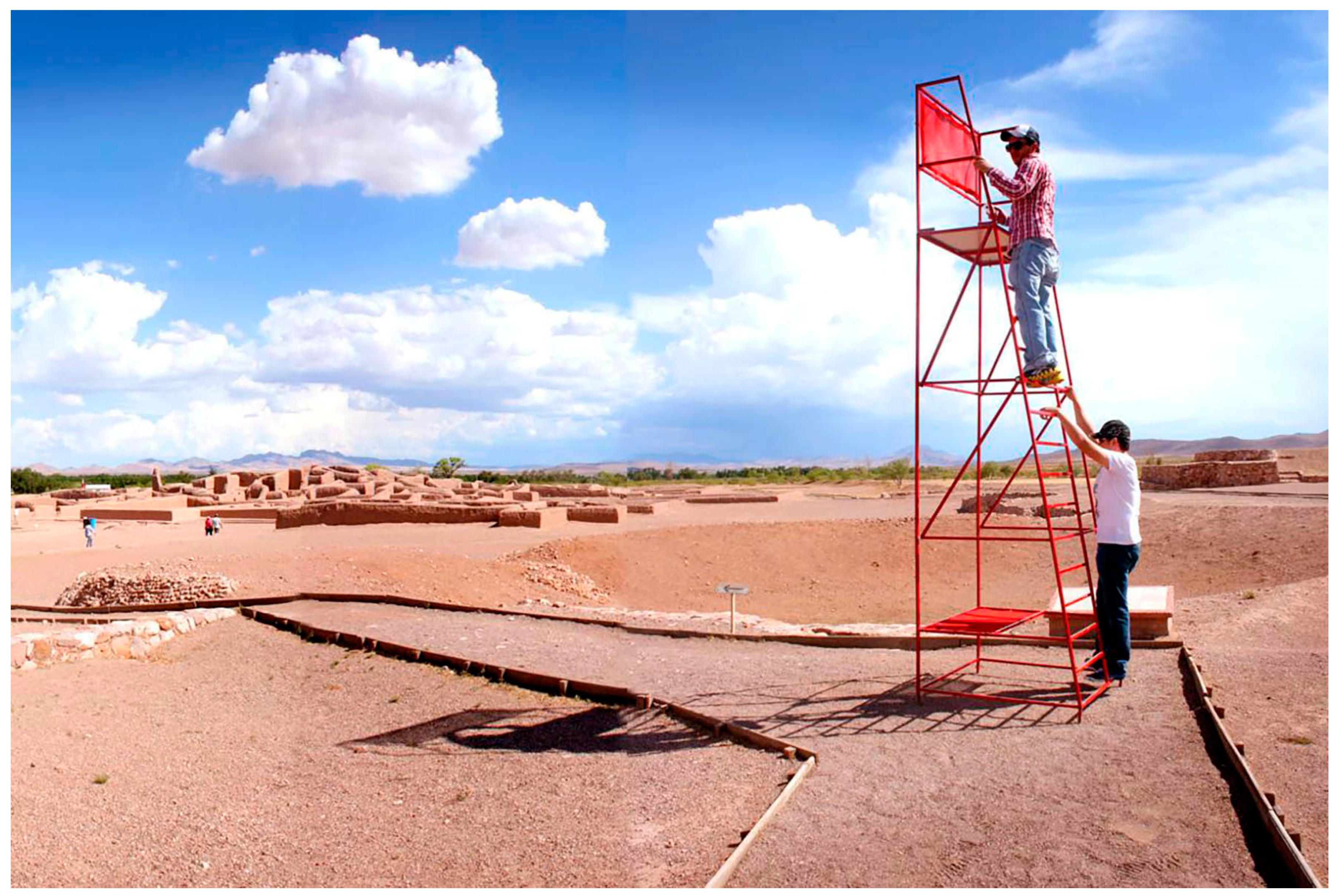
Figure 4.
Atelier delle Verdure, Bosco Raggomitolato, Rome, Italy, 2013 (Courtesy of Atelier delle Verdure).
Figure 4.
Atelier delle Verdure, Bosco Raggomitolato, Rome, Italy, 2013 (Courtesy of Atelier delle Verdure).
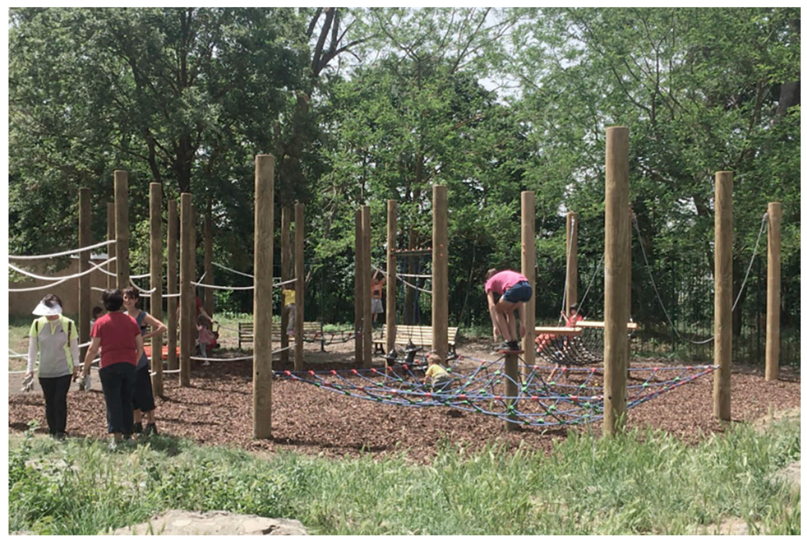
Figure 5.
Atelier Brücker, Núcleo Arqueológico da Rua dos Correiros, Lisbon, Portugal, 2021 (Photo by G.E. Galanello).
Figure 5.
Atelier Brücker, Núcleo Arqueológico da Rua dos Correiros, Lisbon, Portugal, 2021 (Photo by G.E. Galanello).
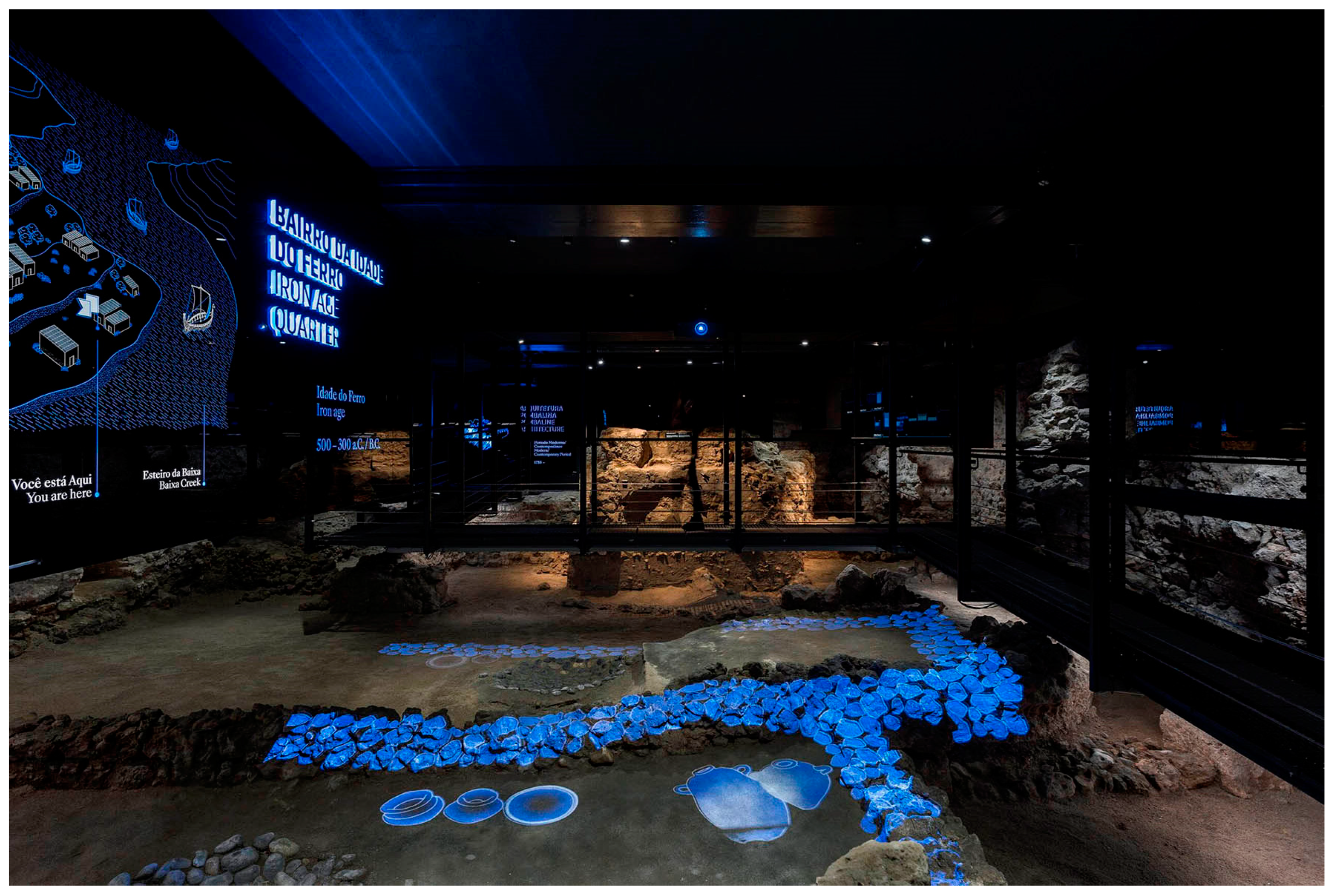
Figure 6.
Filippo Cannata, Temple of Serapis, Pozzuoli, Italy, 2018 (Courtesy of Filippo Cannata).
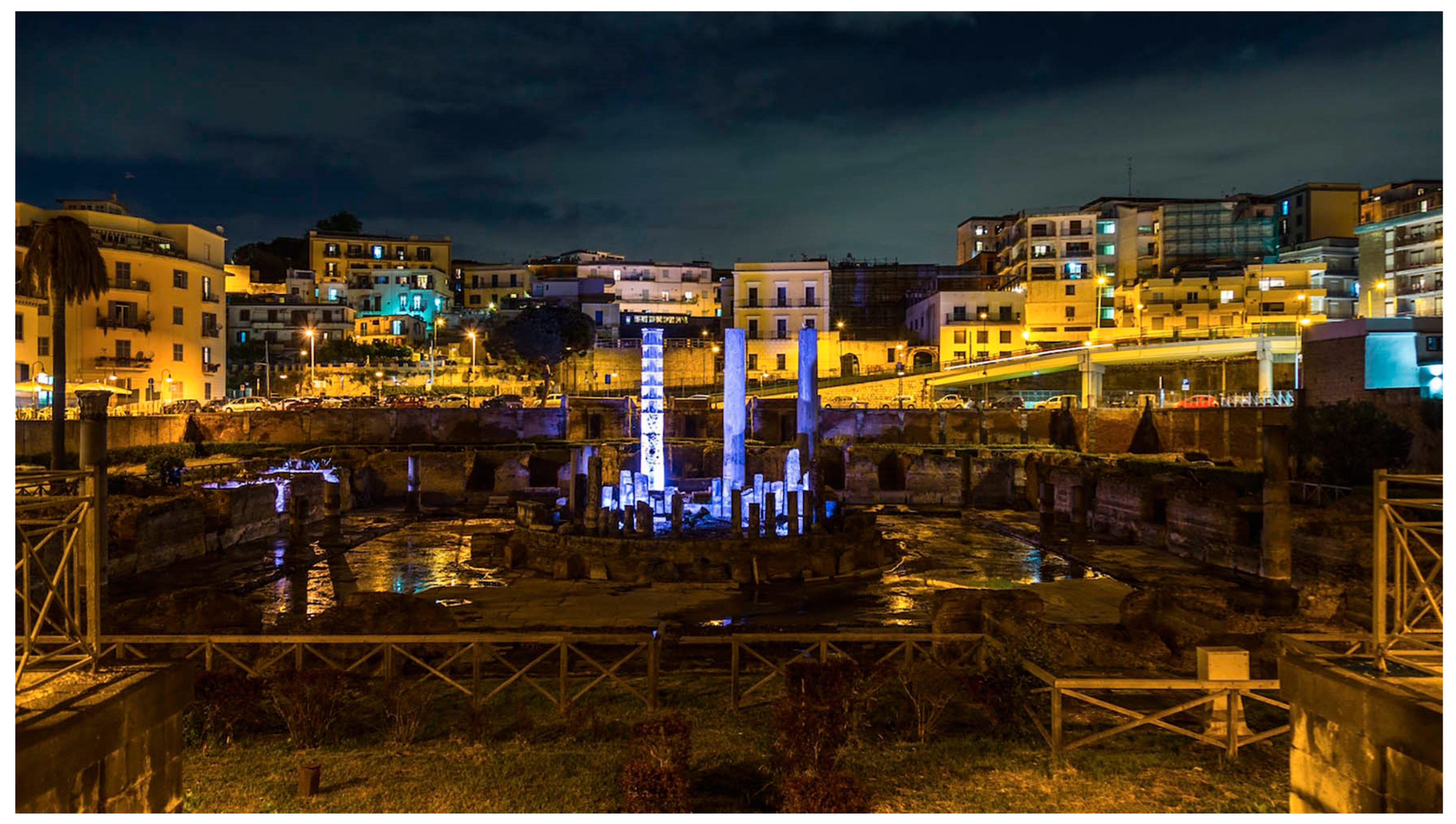
Figure 7.
Archaeological Park of Egnazia, Italy (Source: google maps 2025).
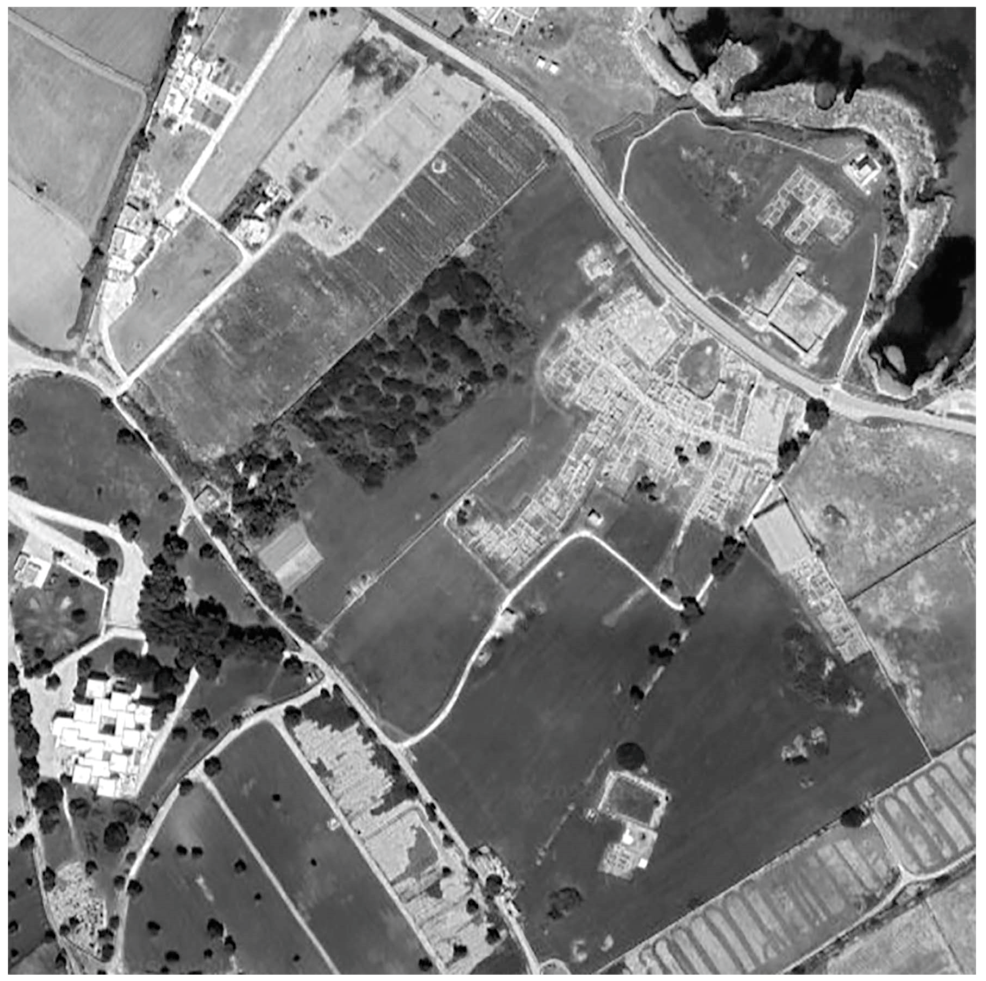
Figure 8.
Site exploration and analysis of the archaeological context. Report, September the 20th of 2025 (Picture by L. Montemurro, D. Porcelli, M. Squeo).
Figure 8.
Site exploration and analysis of the archaeological context. Report, September the 20th of 2025 (Picture by L. Montemurro, D. Porcelli, M. Squeo).
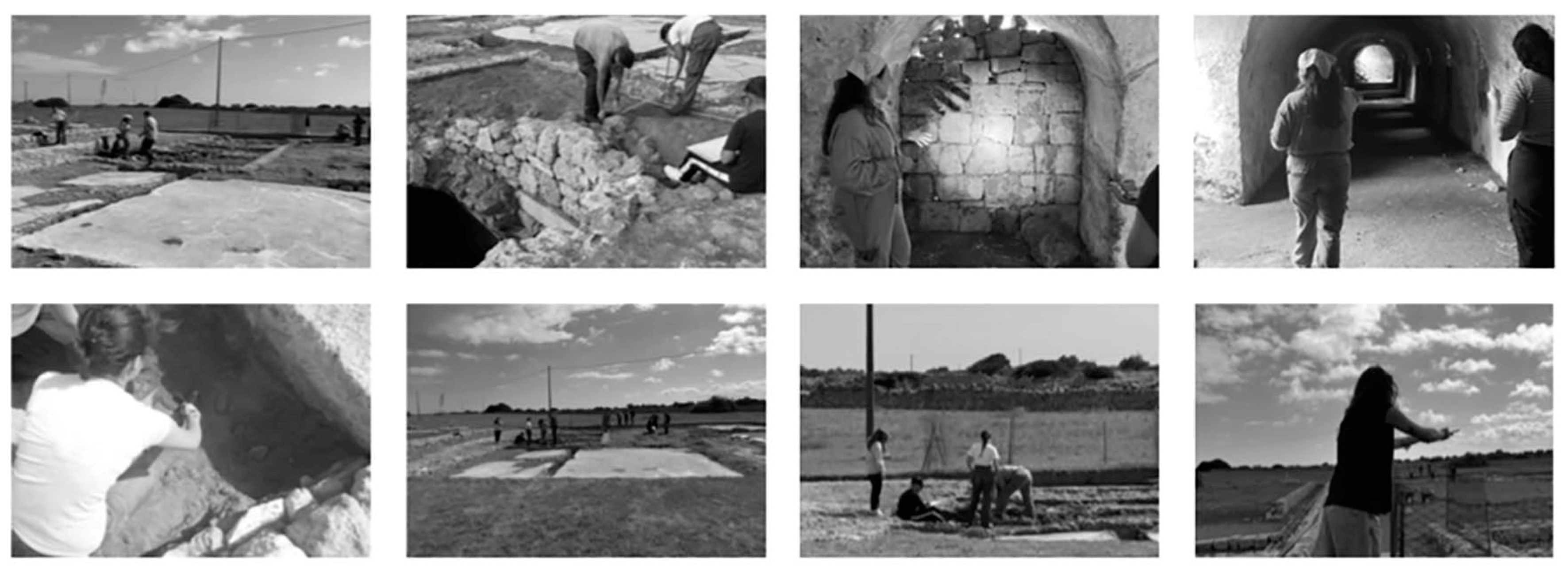
Figure 9.
Archaeological Park of Egnazia, Cyptoporticus. Ground and undergound floor (Drawing by L. Martinelli, D. Porcelli, M. Squeo).
Figure 9.
Archaeological Park of Egnazia, Cyptoporticus. Ground and undergound floor (Drawing by L. Martinelli, D. Porcelli, M. Squeo).
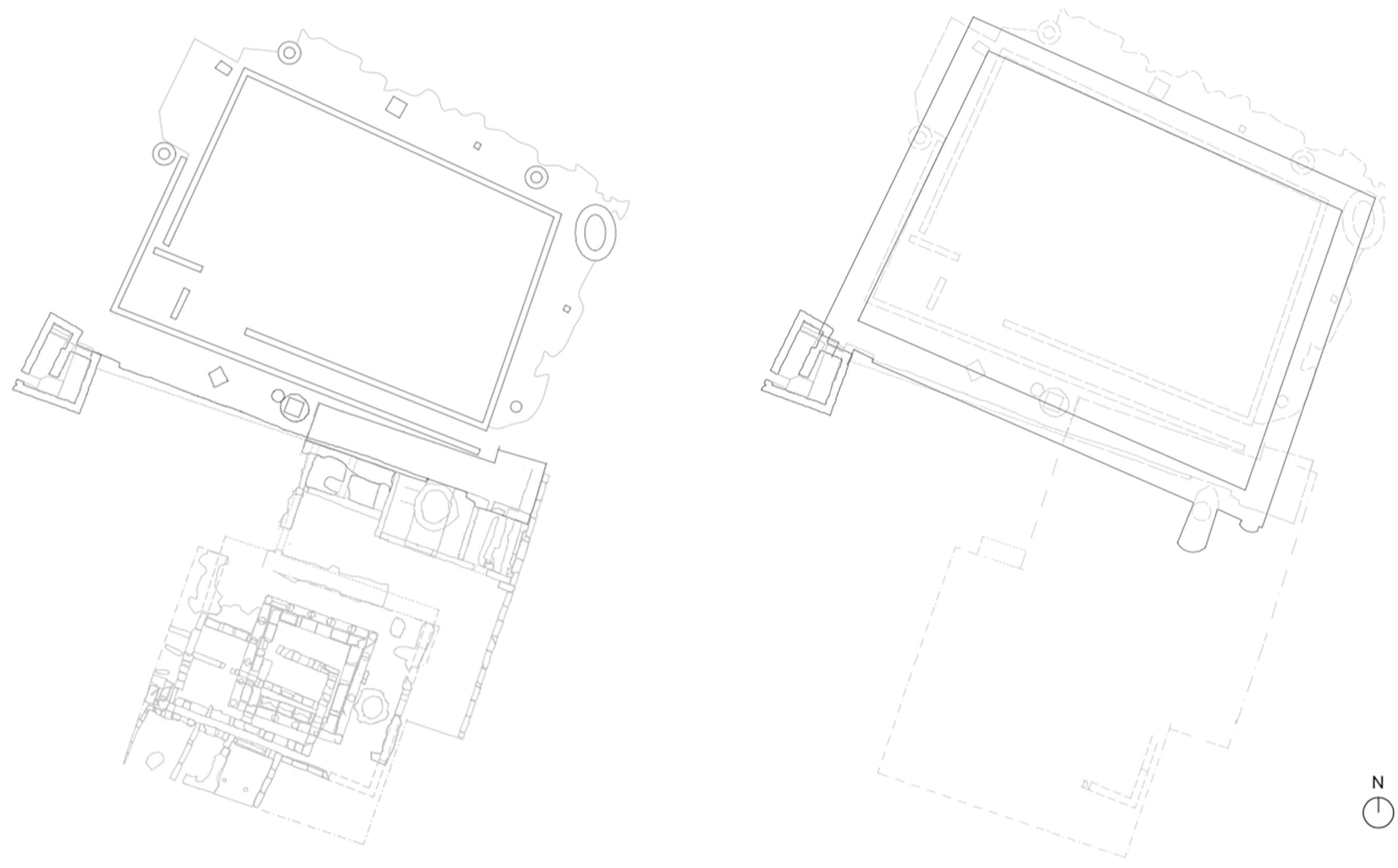
Figure 10.
Design proposal: Shelter for the Cryptoporticus’ Entrance (virtual simulations by L. Martinelli, D. Porcelli, M. Squeo).
Figure 10.
Design proposal: Shelter for the Cryptoporticus’ Entrance (virtual simulations by L. Martinelli, D. Porcelli, M. Squeo).
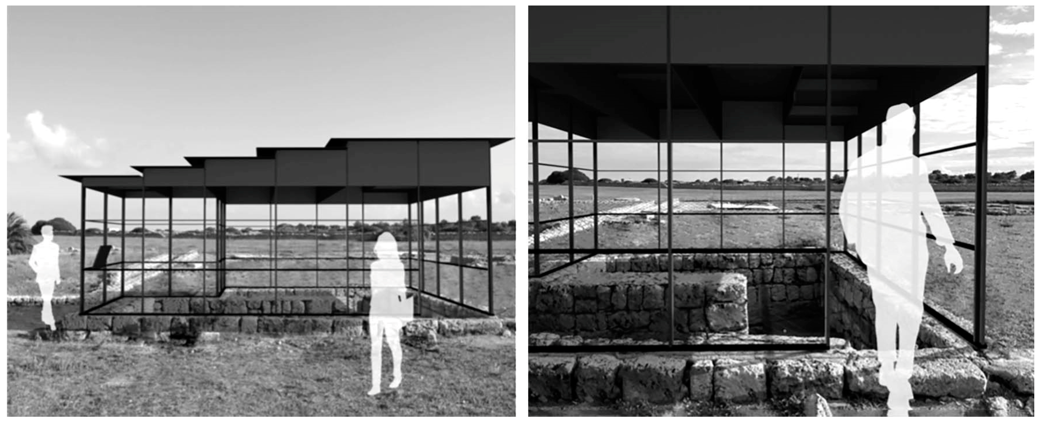
Figure 11.
Design proposal: Fencing systems for the excavation areas (virtual simulations by L. Martinelli, D. Porcelli, M. Squeo).
Figure 11.
Design proposal: Fencing systems for the excavation areas (virtual simulations by L. Martinelli, D. Porcelli, M. Squeo).
Disclaimer/Publisher’s Note: The statements, opinions and data contained in all publications are solely those of the individual author(s) and contributor(s) and not of MDPI and/or the editor(s). MDPI and/or the editor(s) disclaim responsibility for any injury to people or property resulting from any ideas, methods, instructions or products referred to in the content. |
© 2025 by the authors. Licensee MDPI, Basel, Switzerland. This article is an open access article distributed under the terms and conditions of the Creative Commons Attribution (CC BY) license (http://creativecommons.org/licenses/by/4.0/).
Copyright: This open access article is published under a Creative Commons CC BY 4.0 license, which permit the free download, distribution, and reuse, provided that the author and preprint are cited in any reuse.


