
Submitted:
08 April 2025
Posted:
09 April 2025
You are already at the latest version
Abstract
Drones are widely used in urban air pollution monitoring. Although studies have focused on single-drone applications, collaborative applications for air pollution detection are relatively underexplored. This paper presents a 3D cube-based adaptive cooperative search algorithm that allows two drones to collaborate to explore air pollution. The search space is divided into cubic regions, and each drone explores the upper or lower halves of the cubes and collects data from their vertices. The vertex with the highest measurement is selected by comparing the collected data, and an adjacent cube-shaped search area is generated for exploration. The search continues iteratively until any vertex measurement reaches a predefined threshold. An improved algorithm is also proposed to address the divergence and oscillation that occur during the search. In simulations, the proposed method outperformed linear search in terms of CPU time and search distance. Additionally, the cooperative search method using multiple drones was more efficient than was single-drone exploration in terms of the same parameters. In experiments in real-world scenarios, multiple drones equipped with the proposed algorithm successfully detected cubes containing air pollution above the threshold level. The findings serve as an important reference for research on drone-assisted target exploration, including air pollution detection.
Keywords:
Air pollution search algorithm
; Drone application
; Air pollution detection drone
; Drone search algorithm
; Environmental drone application
1. Introduction
Drones have recently been used in a wide range of applications, including air pollution monitoring in urban areas. Air pollution monitoring involves detecting and measuring various air pollution sources in urban spaces for multiple purposes, such as reporting air pollution levels, predicting future pollution levels, and identifying specific sources of pollution. The detection of air pollution sources is particularly challenging because of their intangible, colorless, and dynamic nature [1]. Consequently, effective search algorithms tailored to these characteristics are required [2].
This study proposes a 3D cube-based adaptive cooperative search algorithm to address the challenge of monitoring air pollution in urban areas using a fleet of drones. Given the intangible and colorless nature of air pollution, tracking pollution using solely visual data captured by drone cameras is not feasible. Instead, sensors that are capable of collecting and measuring pollutants such as CO, CO2, PM, NO, and NO2 are used to trace air pollution.
The proposed algorithm focuses on identifying points in a 3D search space where pollutant levels exceed a specific threshold by using sensor measurements. To achieve precise and efficient exploration, the search space is divided into cubic regions, and multiple drones collaborate to systematically explore these cubes. Data collection points are established within each cube and the data are gathered iteratively. By comparing the collected data, the algorithm identifies the point containing the highest pollutant concentration and generates a new cube-shaped search area centered on this point, continuing the search iteratively to locate the target air pollution sources.
The contributions of this study can be summarized as follows:
First, an effective air pollution search algorithm is proposed that introduces an effective method for detecting intangible and dynamic air pollution sources. The proposed 3D cube-based air pollution search algorithm identifies localized high-pollution areas according to sensor-measured pollution levels. By dividing the search space into cubic regions, the algorithm ensures systematic exploration and provides a robust framework for detecting air pollution in 3D spaces.
Second, an adaptive search approach is presented: An adaptive algorithm is proposed that dynamically adjusts the search area based on the data collected at each stage. By exploring cube-shaped spaces and focusing on the points having the highest pollution levels, the algorithm efficiently identifies areas with high pollutant concentrations.
Third, a dynamic space adjustment is used: The algorithm enables dynamic adjustment of the search space. Instead of being restricted to a predefined search area, the algorithm expands or modifies the search region based on the collected data, thereby allowing efficient exploration, even as the search space grows, for as long as the drones’ energy resources permit.
Fourth, a collaborative multidrone search is carried out: A collaborative method for multidrone exploration is proposed. By dividing the search space between multiple drones that conduct searches in parallel, the algorithm reduces redundancy, increases search speed, minimizes drone battery consumption, and extends the overall duration of the mission. This collaboration enables the swift and accurate detection of locations of highly concentrated pollution within the cubic search space, providing an effective solution for air pollution monitoring.
2. Related Works
Airborne air pollution can be considered to be a type of search target for drones. Many drone applications achieve the fundamental objective of detecting targets on the ground or in the air, which enables their use in various fields. Therefore, research on target detection, target tracking, and monitoring with the use of drones can be classified as listed in Table 1. These classes include target detection, mobile target tracking, monitoring & various purposes, and air pollution detection.
Target detection focuses on detecting targets on the ground or in the air. A general approach to understanding this field is to review survey studies that analyze the existing research. For example, Adoni et al. [3] discussed the challenges and communication problems involved in implementing autonomous multiple unmanned aerial vehicle (UAV) systems. Their study emphasized that building cooperative drone systems without human intervention is highly complex and requires some consideration of UAV types, mission complexity, communication architectures, and routing protocols. It also provides a comparative analysis of existing studies and offers guidance for selecting appropriate communication architectures.
Iftikhar et al. [4] highlighted the role of target detection in smart cities, such as traffic congestion management. Object detection in smart city environments is challenging because of factors such as the movement of people or objects, and the small sizes of objects. This study analyzed various deep learning approaches to improve detection accuracy, reduce computational costs, and optimize system design.
Several studies have focused on single-drone target detection. For example, Zhang [5] and Wang et al. [6] explored methods for detecting objects in drone-captured images. Zhang [5] explained that images captured by drones differ from ground-level images in terms of object size, density, occlusion, and lighting conditions. To address these challenges, their study proposed an object detection algorithm based on the YOLOv8 model, which was designed for more effective detection on drone imagery. Wang et al. [6] further stated that UAVs capture images from high altitudes, leading to smaller object sizes and the presence of multiple objects, necessitating specialized target detection algorithms. Their study introduced a YOLOv8-based UAV target detection algorithm tailored to these conditions.
Recent studies have explored collaborative drone target detection and investigated applications in which multiple drones cooperate for target detection. Several notable studies, such as those by Minaeian et al. [7], Zhu et al. [8], Stasinchuk et al. [9], and Alotaibi et al. [10], have contributed to this field. Minaeian et al. [7] examined a method for the tracking and control of crowds in border areas through the cooperation of UAVs and multiple unmanned ground vehicles (UGVs). Zhu et al. [8] proposed a distributed online heuristic strategy to solve the problem of multi-UAV collaborative coverage. Stasinchuk et al. [9] addressed how a team of cooperating autonomous aircraft could safely intercept multiple intruder UAVs. Alotaibi et al. [10] explored how a team of multiple unmanned aerial vehicles could efficiently complete search and rescue missions and save the maximum number of people.
The field of mobile target tracking in target detection research focuses on detecting or tracking targets that move dynamically. Alhafnawi et al. [11] conducted a valuable study for researchers seeking to understand trends in drone-based target tracking. The key design challenges for target-tracking drones were identified, and ideas for addressing them were introduced. Among the studies on mobile target tracking, some have focused on applications that use a single drone, such as those by Wang et al. [12] and Zheng et al. [13]. Wang et al. [12] proposed a framework for tracking moving ground targets using a fixed-wing UAV. Zheng et al. [13] presented a method involving collaboration between humans and UAVs for tracking escaped criminals by introducing a hybrid evolutionary algorithm to explore the search space efficiently.
Research on cooperative applications involving multiple drones in mobile target tracking includes studies by Nathan et al. [14], Cimino et al. [15], Opromolla et al. [16], Hentati et al. [17], Zhou et al. [18], SaaDaoui et al. [19], and Dai et al. [20]. Nathan et al. [14] investigated how autonomous drones detected and tracked concealed targets in densely forested areas. Cimino et al. [15] explored the coordination of UAVs using deep learning methods to detect and track dispersed targets in various search environments. Opromolla et al. [16] studied how drones within a swarm visually recognized other drones using a machine vision approach based on the You Only Look Once (YOLO) module. Hentati et al. [17] proposed a cooperative UAV framework for tracking moving ground objects. Zhou et al. [18] examined a method in which multiple UAVs collaborate to track multiple intruders that are infiltrating military security facilities. SaaDaoui et al. [19] introduced a dynamic UAV formation and target search model using a cooperative particle swarm optimization (PSO) algorithm to track moving ground targets. Dai et al. [20] presented a 3D collaborative trajectory optimization (CTO) approach for tracking multiple UAVs in air. All of these studies contribute to the broader field of ground and aerial target tracking using UAVs.
Third, studies have been conducted on the use of drones for monitoring and other applications. Most of these studies have focused on drone applications for monitoring urban traffic, environmental conditions, and disasters. Some key studies have provided insight into research trends in this field. Alsamhi et al. [21] investigated and analyzed recent research on drone collaboration and Internet of Things (IoT) applications for the realization of smart cities. Popescu et al. [22] examined and analyzed application cases for integrated systems based on wireless sensor networks (WSNs) and UAVs. Gohari et al. [23] conducted a literature review and identified seven research areas related to surveillance drone usage in smart cities. Chmaj et al. [24] explored case studies where multiple UAVs were used in distributed processing for surveillance and environmental monitoring. Eche et al. [25] provided a systematic analysis of the literature related to forest health monitoring (FHM), offering insights into research trends, required technologies, and the advantages and disadvantages of various approaches. Alsamhi et al. [26] analyzed the key technologies, data collection methods, and energy efficiency requirements for green IoT and smart cities by doing a review of the relevant research literature.
Among the studies that have been done on monitoring and other applications, some have focused on single-drone utilization, such as those by Langhammer [27] and Oltmanns et al. [28]. Langhammer [27] explored the use of UAVs to monitor river restoration in urban environments, and Oltmanns et al. [27] introduced UAV applications for soil erosion monitoring. Studies focused on drone collaboration and multidrone applications include those of Fu et al. [29], Elloumi et al. [30], Liao et al. [31], and Pan et al. [32]. Fu et al. [29] investigated energy-efficient methods for allocating search spaces and avoiding collisions when multiple UAVs are tracking aerial targets. Elloumi et al. [30] studied a traffic monitoring system that used multiple UAVs to track vehicles. Liao et al. [31] examined efficient and stable data transmission between drones for environmental monitoring applications. Pan et al. [14] focused on communication protocols and platforms that enabled UAVs to collect and transmit monitoring data from disaster-affected areas.
Fourth, studies related to air pollution detection using drones have focused on atmospheric pollution monitoring. To understand the characteristics and trends of these studies, researchers such as Motlagh et al. [1], Fascista [2], Villa et al. [32], Javaid et al. [33], Ye and Geng [34], Zhou et al. [35], and Motlagh et al. [36] have provided valuable insights. Motlagh et al. [1] presented the key challenges in UAV-based air quality monitoring by doing a literature review and suggested a research roadmap for future studies. Fascista [2] discussed the available solutions and limitations of large-scale environmental monitoring using UAVs. Villa et al. [32] reviewed UAV-based air pollution and emission monitoring studies, analyzed current technological advancements, and identified unresolved challenges. Javaid et al. [33] introduced communication and control methods and application cases in cooperative multi-UAV systems through a literature survey. Geng [34] explained pollution monitoring principles and methodologies for monitoring port environments using UAVs. Zhou et al. [35] categorized UAV swarm intelligence research into five hierarchical levels and discussed the research trends at each level. Motlagh et al. [36] addressed urban-scale air pollution monitoring using UAVs and discussed the vertical distribution of urban air pollution, monitoring requirements, and research challenges.
Among the studies on air pollution detection, various research cases have focused on single-drone applications. Araujo et al. [37] analyzed the performance of air pollution sensors mounted on UAVs under different flight conditions. Alvear et al. [38] proposed a method for mapping air pollution by using a single drone to focus on areas with high pollutant concentrations. Gu et al. [39] introduced a modular UAV-based platform capable of monitoring various air pollutants in real time. Zhou et al. [40] considered the aerodynamics of a six-rotor UAV equipped with air pollution sensors and presented case studies on particulate matter (PM) measurements. Alvear et al. [41] examined the optimal search space size and accuracy of energy-efficient air pollution monitoring by multirotor UAVs. Vega et al. [42] proposed an air pollution monitoring system using UAVs and demonstrated data transmission, information processing, and a graphical user interface (GUI)-based monitoring case study. Pochwala et al. [43] presented a low-cost air pollution sensor system mounted on UAVs and took vertical PM measurements during UAV vertical flights.
Compared with single-drone applications, collaborative UAV applications for air pollution detection are relatively rare. Examples of such studies include those by Liu et al. [44], Fu et al. [45], Bolla et al. [46], Naula et al. [47], and Liu et al. [44], who proposed an AI model that analyzed air pollution haze images captured by a UAV swarm consisting of server UAVs and client UAVs to predict air quality indices. This study demonstrated the efficiency of the model through multiple experiments. Fu et al. [45] presented a research case in which multiple UAVs tracked the dispersion paths of hazardous gas. Bolla et al. [46] proposed a vertical take-off and landing UAV that was capable of studying air quality at different altitudes, and they considered airflow effects from the UAV propellers to determine the vertical drone deployment. Naula et al. [47] introduced an algorithm to locate air pollution sources using UAVs. The algorithm employed a heuristic method to track the gradient of pollutant concentration, and used a probabilistic approach to search promising areas. However, this study was conducted in a controlled indoor environment, rather than in a real-world environment.

Table 1.
Classification of research on drone-based target detection, target tracking, and monitoring.
Table 1.
Classification of research on drone-based target detection, target tracking, and monitoring.
| Drone | Target Detection | Mobile Target Tracking | Air Pollution Detection | Monitoring & Various Purposes |
| Single Drone Operation | [5,6] | [12,13] | [37,38,39,40,41,42,43] | [27,28] |
| Cooperative Flight | [7,8,9,10] | [14,15,16] [17,18,19,20] |
[44,45,46,47] | [29,30,31,32] |
| Survey | [3,4] | [11] | [1,2,32,33,34,35,36] | [21,22,23,24,25,26] |
Our proposed 3D cube-based drone collaborative exploration algorithm offers several key advantages over existing algorithms: The first advantage is its enhanced search efficiency through structured space division: Although many existing studies determine UAV search paths heuristically or by using sensors, our 3D cube-based approach structures the search space systematically and enables efficient drone collaboration. This minimizes redundant searches and optimizes the search trajectories. The second advantage is faster detection of high-pollution areas through collaboration: Unlike single-drone approaches [37,38,39,40,41], our method allows multiple drones to collaborate within cubic units and to identify target areas more quickly. Specifically, it is designed to resolve problems of divergence and oscillatory behavior, thereby ensuring stable and effective exploration. The third advantage is precision search that considers both vertical and horizontal expansions: Although some existing studies [36,47] have suggested vertical exploration, our algorithm leverages a 3D cube structure to balance both vertical and horizontal exploration. This allows for a more precise analysis of the air pollution distribution in both aerial and ground-level regions. The fourth advantage of the algorithm is its adaptive search capability: Many UAV-based search studies follow fixed search paths, whereas our algorithm dynamically adjusts its search patterns according to the pollution concentration. This enables the algorithm to focus on high-concentration areas while minimizing its exploration in low-priority regions, thereby reducing search costs. The fifth advantage of the algorithm is that it is applicable to diverse environments: Some existing studies [44,45,46] have been validated only in limited environments (e.g., indoor experiments and constrained spaces). In contrast, our algorithm is designed to allow multiple drones to collaborate effectively in real-world conditions, enabling deployment in urban areas, industrial zones, and forests.
3. 3D Cube-Based Adaptive Cooperative Search Algorithm
This section explains the advantages of the cube-based exploration method in a 3D space and proposes a 3D cube-based adaptive cooperative search algorithm, in which two drones collaborate to explore the three-dimensional space efficiently.
3.1. Comparison of Exploration Methods in a 3D Space
To compare different data collection strategies within a spherical space, we consider three geometrical approaches: cube-, square-, and triangle-based vertex arrangements, as shown in Figure 1. Each of these methods involves collecting data from specific vertices within a sphere, and they vary in terms of the number of vertices sampled and the spatial coverage.
Triangular-based data collection: This method gathers data from five points: three vertices forming a triangle in a single plane, as well as from the topmost and bottommost points of the sphere. Although this approach is simple and energy-efficient, it provides limited spatial coverage, primarily in the horizontal plane. The vertical dimension is only partially covered by the top and bottom points, which results in less comprehensive 3D coverage than other strategies. It is best suited for scenarios where minimizing the number of data collection points is crucial, such as rapid scanning or energy-constrained operations.
Square-Based Data Collection: With this method, data are collected from six points: four vertices that form a square in a single plane and the topmost and bottommost points of the sphere. This provides a better spatial distribution than does the triangular method, with improved symmetry along the vertical axis. However, the horizontal coverage remains confined to one plane, which leaves gaps in the full 3D distribution. This is particularly useful for applications where vertical data collection is a priority, such as atmospheric monitoring, while maintaining a relatively simple setup with fewer data points.
Cube-Based Data Collection: This method collects data from eight vertices of a cube inscribed within a sphere, and it offers a highly symmetric and evenly distributed spatial coverage across all three dimensions. The cubic structure ensures a comprehensive exploration of the spherical space, making it ideal for detailed 3D mapping. However, movement between vertices may require longer distances, which can be challenging in obstacle-rich environments. This approach is best suited for applications that require high-precision data collection with extensive three-dimensional coverage.
The cube-based data collection method is particularly well-suited for applications such as air pollution monitoring, where comprehensive and detailed spatial coverage is crucial. This method provides an evenly distributed set of data points in three-dimensional space. Each vertex is positioned at the intersection of the x-, y-, and z-axes, thereby ensuring a balanced distribution that covers the entire volume under investigation.
For air pollution monitoring, it is essential to gather data across multiple atmospheric layers to capture variations in pollutant concentrations at different altitudes and locations. The ability of the cube-based method to collect data from vertices distributed across three axes makes it ideal for this purpose. The high symmetry of this method ensures that no single axis or spatial region is overrepresented or underrepresented, and this gives a more accurate and holistic understanding of atmospheric conditions.
Moreover, the comprehensive coverage offered by this method enables the detection of localized pollution sources, which could be missed with less uniformly distributed data collection techniques. The vertices, which are spread at the maximum possible distance from the center of the sphere, allow the system to capture data from a wide range of points, which makes it possible to map pollution gradients more effectively. This is particularly valuable in urban environments, where pollutant levels can vary significantly owing to factors such as traffic, industrial activities, and weather patterns.
Thus, the method’s uniform distribution, extensive spatial coverage, and ability to capture three-dimensional variations make the cube-based data collection method highly suitable for air pollution monitoring, where precise and broad spatial data are essential for accurate assessment and decision-making.
Therefore, we propose an adaptive method for air pollution monitoring that uses a cube-based exploration algorithm, in which multiple drones (in this case, two drones) collaborate to explore a cubic search space. This approach is adaptive because the search area is determined from the results of previous explorations, thereby allowing for dynamic adjustments and more efficient data collection. By focusing on the areas of interest identified during the early stages of exploration, this method ensures comprehensive coverage while optimizing the search process.
3.2. Design of the 3D Cube-Based Adaptive Cooperative Search Algorithm
Figure 2 shows the search process for the proposed algorithm, which operates as follows. First, the cubic space is divided into regions, with each drone assigned to explore a specific area. For example, in the case of two drones, one explores the upper portion of the cube, whereas the other explores the lower portion. Second, each drone systematically visits the data collection points within its assigned cubic region and gathers air pollution data. To ensure accuracy, each cubic search space is explored multiple times (n iterations), which allows for repeated data collection at each point.
Third, after each exploration round, the collected data are examined to determine whether any values exceed a predefined threshold. If any data points are detected above the threshold, the exploration is terminated. If no such data are found, the algorithm proceeds to the next step. Fourth, based on previous exploration results, the adjacent search area is determined, and the exploration region is expanded. Specifically, the average value of the data collected at each of the eight vertices of the cubic space is calculated, and the vertex having the highest value is selected. A new spherical and cubic search space is then generated with the highest point as a reference. The exploration continues according to the method described in step one. This process is repeated until data exceeding the threshold are obtained.
This adaptive exploration algorithm dynamically adjusts the search region according to prior results, ensuring that the drones focus on areas of interest. This method optimizes data collection while maintaining comprehensive coverage by expanding the search space only when required. This approach is particularly effective for air pollution monitoring, where the spatial distribution of pollutants can vary, and an adaptive search strategy can help to identify areas with high pollution levels.
The proposed exploration algorithm can be formalized as follows:
- Notation
Let Ci denote the i-th cube in the search space with 8 vertices, Vi={vi1,vi2,...,vi8}.
Let D1 and D2 represent two drones that explore the upper and lower regions of each cube, respectively.
Let T denote the threshold value for pollution detection.
Let denote the measurement collected at vertex vij of cube Ci during the k-th exploration iteration.
Let n represent the number of iterations per cube for data collection.
Let denote the average measurement at vertex vij over n iterations.
Let be the vertex with the maximum average measurement in cube Ci.
Let Ci+1 be the next cube selected for exploration.
Below are the detailed steps of the algorithm.
- Step 1: Initialization
1. Set the initial cube search count n=0.
2. Set the pollution detection threshold T.
3. Initialize target_found=False.
4. Drones D1 and D2 start from the ground and ascend to the search altitude.
- Step 2: Cooperative Exploration and Data Collection
For each cube Ci,
1. Drones D1 and D2 reach the cube's starting position.
2. Each drone explores a subset of vertices:
D1 explores the upper vertices: .
D2 explores the upper vertices: .
3. Each drone performs n iterations, measuring pollution levels at each assigned vertex.
4. The average measurement at each vertex is computed as:
5. The maximum measured value in the cube is determined as:
- Step 3: Threshold Check and Search Termination
If , the search terminates, and the drones return to the starting point:
Otherwise, the algorithm proceeds to the next step.
Step 4: Adaptive Search for the Next Cube
1. Identify the adjacent cube with the highest neighbor value:
2. If a neighboring cube Ci+1 contains a vertex vmax such that mmax < mneighbor, then the maximum value is updated:
3. If , terminate search.
4. Otherwise, the drones move to the adjacent cube Ci+1 and continue.
Figure 3 shows the cube-based adaptive cooperative search algorithm.
At the beginning of an iteration of the algorithm, the search count (n) and the threshold value (th) for target detection are initialized. The flag target_found is set to False to indicate that the target has not yet been located. The two drones begin their mission from a designated ground position and ascend to their operational altitude. From there, they navigate to the starting position of the first cube in the search space.
Once positioned at the cube, the drones begin their exploration by systematically collecting data from its vertices. Each measurement is recorded and transmitted, and this process is repeated for n iterations to enhance accuracy. After the data are collected, the algorithm processes the gathered information and determines the maximum recorded value within the cube. If this value exceeds the threshold th, the algorithm conducts a secondary search among the neighboring cubes to find a value greater than the threshold. The algorithm compares the highest recorded value within the current cube to those in adjacent cubes and the maximum value is updated accordingly.
If the maximum value in any cube reaches or exceeds the defined target value, the target_found flag is set to True, indicating that the search has been successful. The drones then return to their starting positions to complete the search process. If the target value is not detected, the drones move to the neighboring cube that contains the vertex at which the highest recorded measurement was taken and continue the exploration process. This iterative search strategy ensures that drones systematically navigate the environment and focus on areas with the highest potential target values.
One key feature of this algorithm is its cooperative exploration approach, in which two drones work together to cover a defined cubic search space. Additionally, its adaptive search strategy dynamically adjusts the search direction based on data collected in real time. This ensures efficient data processing, allowing drones to effectively identify and prioritize areas of air pollution with high concentration. The search process terminates immediately when the target value is detected, which optimizes both time and resource utilization.
By iteratively expanding the search to the adjacent cubes having the highest potential values, the algorithm ensures a thorough and efficient exploration of 3D space. This method is particularly useful for applications such as environmental monitoring, pollution detection, and other scenarios that require systematic 3D spatial search capabilities.
The problems of divergence and oscillatory behavior were carefully considered when this algorithm was designed. This approach ensures that the mission can be terminated once air pollution exceeds a certain threshold. However, to identify the 3D cubic cell with the highest value, it is crucial to address these two potential issues.
A divergence problem may arise when no 3D cube cell having the same measurement values is considered after all eight vertices are explored. If one of these equally valued cells is selected, and the search is extended to an adjacent 3D cube cell, the search process may diverge, leading to inefficient exploration. To mitigate this problem, all adjacent 3D cube cells that share the same measurement value should be considered when the search space is expanded.
An oscillatory behavior problem occurs because the search expansion is limited to the eight vertex-connected directions of the current 3D cube cell. This restriction leads to a failure to consider expansions along the same plane or in the vertical (upward and downward) directions, causing the search to oscillate between specific cube cells. To address this issue, before the search is expanded in the eight vertex-connected directions, the algorithm should first consider exploring the cells in the planar and vertical directions relative to the current 3D cube cell.
When two drones are used to cooperatively explore a cubic space in air, several challenges arise, particularly those related to collision avoidance and coordination. The potential issues and solutions addressed in this study are as follows.
First, the flight collision risk problem: Because drones explore the same cubic space, they may risk collision, especially if their paths cross near the edges or vertices of the cube. This problem arises when two drones move after exploring one cube-shaped space and then generate another cube-shaped space based on the highest point. This issue can be resolved by allowing the drone that explored the region where the highest point was found, either in the upper or lower parts of the cube, to move first. For example, when the highest point appears in the upper part of a cube, the drone that explored the upper section moves first to the starting point of the newly formed cube. After a certain time interval, the drone that explored the lower part follows the first drone and moves into the new cube exploration area. Additionally, the two drones are designed to exchange information and maintain a certain distance (approximately 10 m) during their flight to prevent collisions.
Communication latency or failure: While data are collected in a cube-shaped exploration space, the two drones exchange location information with the server and collect data. If communication delays or failures occur, it may be difficult to accurately determine the drones' positions, which could lead to collisions or other problems. To address this, this study was designed so that the drones remain in their current positions and wait until normal communication is restored. Additionally, when the two drones send collected data to the server, which occurs periodically, communication delays or failures can hinder the reception and processing of data, making it difficult to proceed to the next step. To resolve this issue, this study assigns a drone ID to the collected data and adjusts the data transmission intervals to ensure that the server receives data from both drones consistently.
Third, the problem is limited by energy management and the exploration area: drones have a limited battery life, which means that they must complete their mission within a constrained timeframe. If the threshold value is not detected within the lifetime of the battery, the drones may experience power failure or other problems. Additionally, excessive expansion of the exploration area may lead to communication difficulties with the server or make it challenging for the drones to return to their starting point. To address these concerns, this study restricts the exploration flight time based on battery life and limits the exploration area to a defined range, thereby ensuring that the mission can be completed without power- or communication-related issues.
4. Performance Analysis
A performance analysis of the proposed 3D cube-based adaptive cooperative search algorithm was conducted. First, various simulations were performed to demonstrate that the proposed search algorithm is more efficient than other methods. To evaluate the performance of the proposed algorithm in a real-world environment, a quadcopter drone equipped with the proposed algorithm was developed and tested in real-world experiments. The results were then analyzed.
4.1. Simulation
Various simulations were conducted to analyze the performance of the proposed 3D cube-based adaptive cooperative search algorithm. Table 2 lists the simulation conditions. The search space was a three-dimensional area consisting of 10 cells along the x-, y-, and z-axes. A single air pollution target with the highest concentration was randomly determined at the beginning of each round. Depending on the simulation mode, one or two drones cooperated in the search. The maximum number of cells that could be explored per round was set to 1,000. Figure 4 illustrates the simulation environment. The drone begins its search from the center of the three-dimensional search space and explores a randomly determined air pollution target in each round. It is assumed that the target contains the highest air pollution concentration and that the surrounding pollution levels gradually decrease.
In the simulation, four search methods were compared: (1) the proposed 3D cube-based search algorithm executed by a single drone (CubeSearch(D1)), (2) the proposed algorithm executed cooperatively by two drones (CubeSearch(D1+D2)), (3) a linear search method that explores the search space sequentially (Linear), and (4) the proposed algorithm applied without considering divergence or oscillation (Divergence(D1)).
The results of conducting searches over 100 rounds with randomly generated targets in the search area are shown in Figure 5. As illustrated in Figure 5, CubeSearch(D1), CubeSearch(D1+D2), and the linear method achieved a 100% search success rate, whereas the divergence (D1) method exhibited a success rate of only 85%, owing to divergence and oscillation.
Figure 6 presents the search distance per round for each method and Figure 7 displays the CPU time per round. Compared with the CubeSearch methods, the Linear and Divergence methods demonstrated relatively higher search distances and longer CPU times. Figure 8 shows the cumulative search distance over 100 rounds for each method, and Figure 9 shows the cumulative CPU time over 100 rounds.
Figure 10 shows the Total CPU Time for each method. Figure 10(a) presents the data for comparing between the four methods, showing that the CPU Time for the Linear and Divergence methods is relatively high. Figure 10(b) shows the CPU Time when the proposed cube-based search is performed using one and two drones. As shown in the figure, a cooperative search with two drones results in a shorter CPU Time than does a search with a single drone. This demonstrates that a cooperative search using two drones was more effective than a search using a single drone. As shown in the figure, the linear search method required approximately 21 times more CPU time than did the proposed method, whereas the divergence method required approximately 81 times more CPU time. Additionally, the method using a single drone consumed approximately 2.6 times more CPU time than did the cooperative search method using two drones.
Figure 11 shows the Total Search Distance for each method. Figure 11(a) presents data for comparing the four methods, showing that the search distance for the Linear and Divergence methods were relatively high. Figure 11(b) shows the Search Distance when the proposed cube-based search is performed using one and two drones. As shown in the figure, a cooperative search with two drones results in a shorter Search Distance than does a search with a single drone. This demonstrates that a cooperative search using two drones is more effective than a single-drone search in terms of the search distance. As shown in the figure, the linear search method requires an approximately 23 times greater travel distance than does the proposed method, whereas the Divergence method requires approximately 155 times greater travel distance. Additionally, the method using a single drone requires about 2 times the travel distance of the cooperative search method using two drones.
Figure 12 shows the cumulative number of searched cubes for over 100 rounds for each method. Figure 13 shows the total number of searched cubes for each method. As shown in the figures, the proposed Cube Search method resulted in a lower number of searched cubes. That is, the linear search method explored approximately 122 times more cubes than did the proposed method, whereas the divergence method explored 42 times more cubes. The methods using one drone and two drones explored the same number of cubes. This is because the same algorithm was used, with the only difference being the number of drones used. This demonstrates that the proposed method was able to successfully complete a search while exploring fewer cubes, indicating a smaller search space.
4.2. Development of a Quadcopter for Air Pollution Detection
We designed an experimental drone to implement the proposed algorithm. As shown in Figure 3, the drones were developed in the form of quadcopters, with two drones created for cooperative exploration flights. Each drone was equipped with various air pollution sensors, including PM and CO/CO2 sensors, to ensure the accurate detection of atmospheric pollutants. In addition, GPS sensors were integrated into the drones to ensure precise navigation and collision avoidance. A Low-Rank Adaptation (LoRa) communication module was installed to communicate with the server. The specific hardware specifications of the developed drones are listed in Table 3.
The drone developed for air pollution monitoring in this study is shown in Figure 14. The system controller was selected so as to have sufficient processing power to ensure that there were no delays or errors in communication. Air pollution sensors, including PM and CO sensors, were strategically positioned to minimize the effect of the propellers on the accuracy of the measurements. The communication module was positioned to optimize connectivity with the ground server, and the battery was positioned to maintain the center of gravity of the drone. Both drones were equipped with identical hardware components to ensure consistent performance. However, the software embedded in the controllers was assigned unique IDs to distinguish the two units during cooperative operations.
4.3. Experiments
The proposed 3D cube-based adaptive cooperative search algorithm was tested in a real-world environment by equipping a developed quadcopter drone with the algorithm. The experimental conditions are listed in Table 4. Real-world experiments were conducted at two different sites: a university campus playground in a relatively urban area and an outdoor playground that was relatively distant from the buildings. Because the maximum level of air pollution within the search area was unknown, a threshold value was set, and the search ended when a level exceeding the threshold was detected. If the threshold level was not detected, the search could become out of control; therefore, the Maximum Search Altitude and Maximum Search Width were set to ensure that the search was conducted within a limited space. From the ground, the two drones began their search approximately 30 m apart under the command of the server. All the controls for cooperative drone flights were autonomous. The search ended when the air pollution level that was set as the threshold was detected under the cooperative flight of the two drones, and the drones returned to their starting point. Figure 15 shows the air pollution search results for the two cooperating drones at Site 1. Figure 15(a) shows the process of searching for a CO2 threshold of 450 ppm; Figure 15(b) displays the latitude and longitude of the drones during the search; Figure 15(c) tracks the drones' trajectory against a real-world background; and Figure 15(d) shows the trajectory of the drones in 3D.
Figure 16 shows the air pollution search results for a cooperative search by the two drones at Site 2. Figure 16(a) shows the process of searching for a CO2 threshold of 444 ppm; Figure 16(b) displays the latitude and longitude information for the drones during the search; Figure 16(c) tracks the drones' trajectory against the real-world background; and Figure 16(d) shows the trajectory of the drones in 3D.
5. Discussion
Through simulations, it was demonstrated that the proposed search method outperformed the linear search method, and that the cooperative search method using two drones was superior to the method using a single drone. Furthermore, the effectiveness of the proposed algorithm was validated through real-world experiments using quadcopter drones equipped with the algorithm. In this section, we discuss several key points related to the design of the algorithm, simulation process, development of the quadcopter, and execution of real-world experiments.
First, we discuss the uncertainty in the distribution of air pollution gases within the search space and the cube-based search method: Owing to the uncertainty in the distribution of air pollution gases within the search space, we selected a cube-based search method to allow for more precise exploration. There may be multiple cubic spaces that contain pollution levels that exceed the threshold; however, the proposed algorithm targets the space that was first explored according to a cube-based search. The algorithm can be modified and extended to explore regions having pollution levels above a threshold. Although simulations can use the cube with the highest pollution level to conduct the search, the highest pollution value in real environments is unknown, thus it is more reasonable to terminate the search once a value exceeding the threshold is detected.
Second, we discuss drone hardware development issues: In terms of drone hardware development, issues such as sensor sensitivity and accuracy, sensor attachment location, battery operation time, and drone attitude control must be considered. The sensors used in this study were relatively standard and inexpensive, as listed in Table 3. Because the air pollution levels in the cubic units of the search space did not vary greatly, sensors having higher performance are needed to accurately identify pollution locations. Regarding sensor placement, studies such as that of Araujo et al. [37] discussed optimal sensor positioning to minimize the effects of propeller and drone flights. The selection of an appropriate battery is a critical factor in drone exploration. This choice is closely tied to the performance of the propeller motors, as well as the search time and depth. High-capacity batteries are needed to cover a wider area and to supply powerful motors; however, considerations such as drone weight and reduced exploration time must also be considered.
Third, we discuss issues related to the drone cooperative search: The proposed 3D cube-based adaptive cooperative search algorithm was designed for two drones to cover a cube-shaped search space and explore it cooperatively. This algorithm could be extended to allow more drones to participate in searches. However, additional considerations include the cost of adding more drones, the potential for drone collisions during movement within the cube space, and higher complexity of the algorithm.
6. Conclusions
In this study, a 3D cube-based adaptive cooperative search algorithm for air pollution exploration was proposed, and its efficiency was validated through simulations and experiments. The simulation results showed that the proposed method achieved a target detection rate that was approximately 15% higher than that of linear search. In terms of CPU time, the linear search consumed 24-fold more time than did the proposed method, whereas the Divergence method required 82-fold more time. Regarding the search distance, the linear search required 21 times greater movement distance and the Divergence method required 155 times greater distance than did the proposed method. Additionally, the linear search explored 122 times more cubes than did the proposed method over 100 rounds, whereas the Divergence method explored 42 times more cubes than did the proposed method.
When the single-drone search method was compared with the cooperative search method using two drones under the same algorithm, the single-drone method required approximately 2.6 times more CPU time than did the two-drone cooperative search. Similarly, in terms of search distance, the single-drone method required approximately twice the search distance than did the cooperative search. These results demonstrate that the proposed cube-based cooperative search using multiple drones is more efficient than are other methods.
To validate the effectiveness of the proposed algorithm, two quadcopter-based drones were developed, as shown in Figure 14, and the proposed algorithm was implemented. Real-world air pollution exploration experiments were conducted at two locations: a university sports field in an urban area and an open outdoor space. The experimental results confirmed that the drones equipped with the proposed algorithm successfully completed their mission by autonomously searching for areas that exceeded the threshold pollution level in accordance with the algorithm. Therefore, the proposed algorithm is applicable to real-world air-pollution exploration environments.
Based on the research process and conclusions, the significance of this study can be summarized as follows.
First, a novel and practically applicable algorithm for air pollution exploration was proposed. A search method was developed to explore the vertices of cube-shaped spaces, identify the highest pollution concentration point, and connect to new cube search spaces accordingly. This approach allowed for a more detailed exploration of a given search space and enabled a rational expansion of the search area. The proposed search method was validated through simulations and real-world experiments, which demonstrated its efficiency and effectiveness.
Second, a well-connected and comprehensive study was conducted to address air pollution. Initially, an investigation of the search space led to the development of a cube-based search method. Accordingly, a cooperative search algorithm that would be suitable for multiple drones was designed, and its efficiency was verified through simulations. Subsequently, drone hardware was developed for real-world applications, and the designed algorithm was implemented in drones, which was followed by the execution of real-world experiments. This continuous development and experimentation process adds value to the research model for drone-based air pollution exploration. Before this study was conducted, a literature review on drone-based target detection, tracking, and monitoring was conducted. This study is expected to serve as an important reference for future studies on drone-assisted target exploration, including air pollution detection.
Funding
This research was supported by the Basic Science Research Program through the National Research Foundation of Korea (NRF) funded by the MINISTRY OF EDUCATION (grant number 2021R1I1A3044091).
Institutional Review Board Statement
Not applicable.
Informed Consent Statement
Not applicable.
Data Availability Statement
Data are contained within the article.
Conflicts of Interest
The authors declare no conflicts of interest.
Abbreviations
The following abbreviations are used in this manuscript:
| CTO | Collaborative trajectory optimization |
| FHM | Forest health monitoring |
| GUI | Graphical user interface |
| IoT | Internet of Things |
| LoRa | Low-Rank Adaptation |
| PSO | Particle swarm optimization |
| PM | Particulate matter |
| UAV | Unmanned aerial vehicle |
| UGV | Unmanned ground vehicle |
| WSN | Wireless sensor network |
| YOLO | You Only Look Once |
References
- Hossein Motlagh, N.; Kortoçi, P.; Su, X.; Lovén, L.; Hoel, H.K.; Bjerkestrand Haugsvær, S.; Srivastava, V.; Gulbrandsen, C.F.; Nurmi, P.; Tarkoma, S. Unmanned Aerial Vehicles for Air Pollution Monitoring: A Survey. IEEE Internet Things J 2023, 10, 21687–21704. [Google Scholar] [CrossRef]
- Fascista, A. Toward integrated large-scale environmental monitoring using WSN/UAV/Crowdsensing: A review of applications, signal processing, and future perspectives. Sensors (Basel) 2022, 22, 1824. [Google Scholar] [CrossRef] [PubMed]
- Adoni, W.; Lorenz, S; Fareedh, J; Gloaguen, R.; Bussmann, M. Investigation of Autonomous Multi-UAV Systems for Target Detection in Distributed Environment: Current Developments and Open Challenges. Drones 2023, 7, 1–37. [Google Scholar] [CrossRef]
- Iftikhar, S.; Asim, M.; Zhang, Z.; Muthanna, A.; Chen, J.; El-Affendi, M.; Sedik, A.; Abd El-Latif, A.A. Target detection and recognition for traffic congestion in Smart cities using deep learning-enabled UAVs: A review and analysis. Appl Sci 2023, 13, 1–26. [Google Scholar] [CrossRef]
- Zhang, Z.; Drone, Y.O.L.O. An efficient neural network method for target detection in drone images. Drones 2023, 7, 1–23. [Google Scholar] [CrossRef]
- Wang, F.; Wang, H.; Qin, Z.; Tang, J. UAV target detection algorithm based on improved YOLOv8. IEEE Access 2023, 11, 116534–116544. [Google Scholar] [CrossRef]
- Minaeian, S.; Liu, J.; Son, Y.J. Vision-based target detection and localization via a team of cooperative UAV and UGVs. IEEE Trans Syst Man Cybern Syst 2016, 46, 1005–1016. [Google Scholar] [CrossRef]
- Zhu, K.; Han, B.; Zhang, T. Multi-UAV distributed collaborative coverage for target search using heuristic strategy. Guid Navigat Control 2021, 1, 1–24. [Google Scholar] [CrossRef]
- Stasinchuk, Y; Vrba, M.; Petrlik, M.; Baca, T.; Spurny, V.; Hert, D.; Zaitlik, D; T. Nascimento; M. Saska. A multi-UAV system for detection and elimination of multiple targets. In Proceedings of the 2021 IEEE International Conference on Robotics and Automation (ICRA), Xian China OCT 2021, 2021; Vol. 18. [CrossRef]
- Alotaibi, E.T.; Alqefari, S.S.; Koubaa, A. LSAR: Multi-UAV collaboration for search and rescue missions. IEEE Access 2019, 7, 55817–55832. [Google Scholar] [CrossRef]
- Alhafnawi, M.; Bany Salameh, H.A.; Masadeh, A.; Al-Obiedollah, H.; Ayyash, M.; El-Khazali, R.; Elgala, H. A survey of indoor and outdoor UAV-based target tracking systems: Current status, challenges, technologies, and future directions. IEEE Access 2023, 11, 68324–68339. [Google Scholar] [CrossRef]
- Wang, X.; Zhu, H.; Zhang, D.; Zhou, D.; Wang, Z. Using a fixed-wing UAV vision- based detection and tracking of a mobile ground target using a fixed- wing UAV. Int J Adv Robot Syst 2014, 11, 1–11. [Google Scholar] [CrossRef]
- Zheng, Y.J.; Du, Y.C.; Ling, H.F.; Sheng, W.G.; Chen, S.Y. Evolutionary collaborative human-UAV search for escaped criminals. IEEE Trans Evol Computat 2020, 24, 217–231. [Google Scholar] [CrossRef]
- Amala Arokia Nathan, R.J.; Kurmi, I.; Bimber, O. Drone swarm strategy for the detection and tracking of occluded targets in complex environments. Commun Eng 2023, 2, 1–12. [Google Scholar] [CrossRef]
- Cimino, M.; Lega, M.; Monaco, M.; Vaglini, G. Adaptive exploration of a UAVs swarm for distributed targets detection and tracking. In Institutional Research Information System; SCITEPRESS - Science and Technology Publications, 2019; Vol. 1; pp. 837–844. [CrossRef]
- Opromolla, R.; Inchingolo, G.; Fasano, G. Airborne visual detection and tracking of cooperative UAVs exploiting deep learning. Sensors (Basel) 2019, 19, 4332. [Google Scholar] [CrossRef]
- Hentati, A.I.; Fourati, L.C.; Rezgui, J. Cooperative UAVs framework for Mobile Target Search and tracking. Comput Electr Eng 2022, 101, 1–13. [Google Scholar] [CrossRef]
- Zhou, L.; Leng, S.; Liu, Q.; Wang, Q. Intelligent UAV swarm cooperation for multiple targets tracking. IEEE Internet Things J 2022, 9, 743–754. [Google Scholar] [CrossRef]
- Saadaoui, H.; Bouanani, F.E.; Illi, E. Information sharing based on local PSO for UAVs cooperative search of moved targets. IEEE Access 2021, 9, 134998–135011. [Google Scholar] [CrossRef]
- Dai, J.; Pu, W.; Yan, J.; Shi, Q.; Liu, H. Multi-UAV collaborative trajectory optimization for asynchronous 3-D passive multitarget tracking. IEEE Trans Geosci Remote Sensing 2023, 61, 1–16. [Google Scholar] [CrossRef]
- Alsamhi, S.H.; Ma, O.; Ansari, M.S.; Almalki, F.A. Survey on Collaborative Smart Drones and Internet of Things for Improving Smartness of Smart Cities. IEEE Access 2019, 7, 128125–128152. [Google Scholar] [CrossRef]
- Popescu, D.; Stoican, F.; Stamatescu, G.; Chenaru, O.; Ichim, L. A survey of collaborative UAV–WSN systems for efficient monitoring. Sensors (Basel) 2019, 19, 4690. [Google Scholar] [CrossRef]
- Gohari, A.; Ahmad, A.B.; Rahim, R.B.A.; Supa’at, A.S.M.; Abd Razak, S.; Gismalla, M.S.M. Involvement of surveillance drones in smart cities: A systematic review. IEEE Access 2022, 10, 56611–56628. [Google Scholar] [CrossRef]
- Chmaj, G.; Selvaraj, H. Distributed processing applications for UAV/drones: A survey. Adv Intell Syst Comput 2015, 366, 449–454. [Google Scholar] [CrossRef]
- Ecke, S.; Dempewolf, J.; Frey, J.; Schwaller, A.; Endres, E.; Klemmt, H.J.; Tiede, D.; Seifert, T. UAV-based forest health monitoring: A systematic review. Remote Sens 2022, 14, 1–45. [Google Scholar] [CrossRef]
- Alsamhi, S; Afghah, F; Sahal, R; Hawbani, A; Qaness, M; Lee, B; Guizani. M. Green internet of things using UAVs in B5G networks: A review of applications and strategies. Ad Hoc Networks 2021 117, 1–16. [CrossRef]
- Langhammer, J. UAV monitoring of stream restorations. Hydrology 2019, 6, 1–22. [Google Scholar] [CrossRef]
- D’Oleire-Oltmanns, S.; Marzolff, I.; Peter, K.D.; Ries, J.B. Unmanned aerial vehicle (UAV) for monitoring soil erosion in Morocco. Remote Sens 2012, 4, 3390–3416. [Google Scholar] [CrossRef]
- Fu, Z.; Mao, Y.; He, D.; Yu, J.; Xie, G. Secure multi-UAV collaborative task allocation. IEEE Access 2019, 7, 35579–35587. [Google Scholar] [CrossRef]
- Elloumi, M.; Dhaou, R.; Escrig, B.; Idoudi, H.; Saidane, L.A. Monitoring road traffic with a UAV-based system. In Proceedings of the IEEE Wireless Communications and Networking Conference; IEEE: New York, 2018; pp. 1–6. [Google Scholar] [CrossRef]
- Liao, S.; Wu, J.; Li, J.; Bashir, A.K.; Yang, W. Securing collaborative environment monitoring in smart cities using blockchain enabled software-defined internet of drones. IEEE Internet Things M 2021, 4, 12–18. [Google Scholar] [CrossRef]
- Villa, T.; Gonzalez, F.; B. Miljievic; Z. Ristovski; L. Morawska. An overview of small unmanned aerial vehicles for air quality measurements: Present applications and future prospectives. Sensors 2016, 16, 1–29. [CrossRef]
- Javaid, S.; Saeed, N.; Qadir, Z.; Fahim, H.; He, B.; Song, H.; Bilal, M. Communication and control in collaborative UAVs: Recent advances and future trends. IEEE Trans Intell Transp Syst 2023, 24, 5719–5739. [Google Scholar] [CrossRef]
- Ye, Y.; Geng, P. A review of air pollution monitoring technology for ports. Appl Sci 2023, 13, 1–15. [Google Scholar] [CrossRef]
- Zhou, Y.; Rao, B.; Wang, W. UAV Swarm intelligence: Recent advances and future trends. IEEE Access 2020, 8, 183856–183878. [Google Scholar] [CrossRef]
- Motlagh, N.H.; Irjala, M.; Zuniga, A.; Lagerspetz, E.; Rantala, V.; Flores, H.; Nurmi, P.; Tarkoma, S. Toward blue skies: City-scale air pollution monitoring using UAVs. IEEE Con Electron Mag 2023, 12, 21–31. [Google Scholar] [CrossRef]
- Araujo, J.O.; Valente, J.; Kooistra, L.; Munniks, S.; Peters, R.J.B. Experimental flight patterns evaluation for a UAV-based air pollutant sensor. Micromachines 2020, 11, 768. [Google Scholar] [CrossRef]
- Alvear, O.; Zema, N.R.; Natalizio, E.; Calafate, C.T. Using UAV-based systems to monitor air pollution in areas with poor accessibility. J Adv Transp 2017, 8204353, 14 pp. [CrossRef]
- Gu, Q.; Michanowicz, D.; Jia, C. Developing a modular unmanned aerial vehicle (UAV) platform for air pollution profiling. Sensors 2018, 18, 4363. [Google Scholar] [CrossRef]
- Zhou, S.; Peng, S.; Wang, M.; Shen, A.; Liu, Z. The characteristics and contributing factors of air pollution in Nanjing: A case study based on an unmanned aerial vehicle experiment and multiple datasets. Atmosphere 2018, 9, 1–25. [Google Scholar] [CrossRef]
- Alvear, O.; Calafate, C.; Zema, N.; Matalizio, E.; Orallo, E.; Cano, J.; Manzoni, P. A discretized approach to air pollution monitoring using UAV-based sensing. Mob Netw Appl 2018, 23, 1693–1702. [Google Scholar] [CrossRef]
- Hernández-Vega, J.I.; Varela, E.R.; Romero, N.H.; Hernández-Santos, C.; Cuevas, J.L.S.; Gorham, D.G.P. Internet of things (IoT) for monitoring air pollutants with an unmanned aerial vehicle (UAV) in a smart city. Lect Notes Inst Comput Sci Soc Inform Telecommun Eng 2018, 213, 108–120. [Google Scholar] [CrossRef]
- Pochwala, S; Gardecki, A.; Lewandowski, P.; Somogyi, V.; Anweiler, S. Developing of low-cost air pollution sensor—measurements with the unmanned aerial vehicles in Poland. Sensors 2020, 20, 1–17. [Google Scholar] [CrossRef]
- Liu, Y.; Nie, J.; Li, X.; Ahmed, S.H.; Lim, W.Y.B.; Miao, C. Federated learning in the sky: Aerial-ground air quality sensing framework with UAV swarms. IEEE Internet Things J 2021, 8, 9827–9837. [Google Scholar] [CrossRef]
- Fu, Z.; Chen, Y.; Ding, Y.; He, D. Pollution source localization based on multi-UAV cooperative communication. IEEE Access 2019, 7, 29304–29312. [Google Scholar] [CrossRef]
- Bolla, G.; Casagrande, M.; Comazzetto, A.; Moro, R.; Destro, M.; Fantin, E.; Colombatti, G.; Aboudan, A.; Lorenzini, E. ARIA: Air Pollutants Monitoring Using UAVs. In Proceedings of the 2018 5th IEEE International Workshop on Metrology for AeroSpace (MetroAeroSpace), Rome Italy, 20-22 June 2018. [Google Scholar]
- Naula, N.Y.; Castanon, L.E.G.; Zhang, Y; Avila, L.I.M. UAV-based air pollutant source localization using combined metaheuristic and probabilistic methods. Appl Sci 2019, 9, 1–18. [Google Scholar] [CrossRef]
Figure 1.
Different data collection strategies within a spherical space.
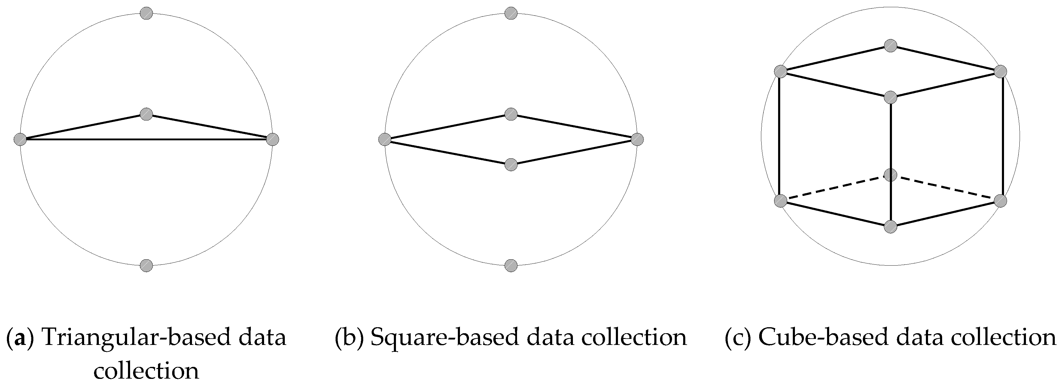
Figure 2.
Basic concept of 3D cube-based cooperative exploration.
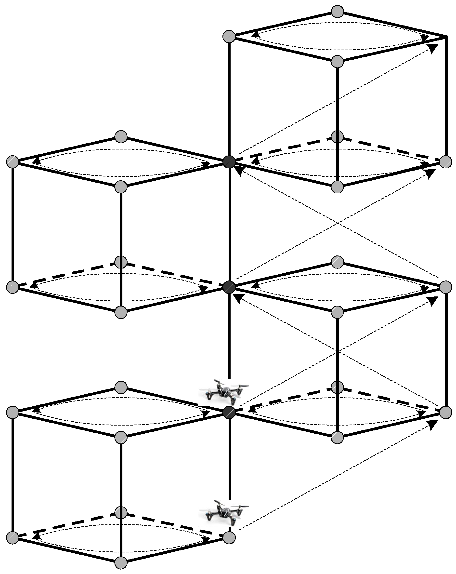
Figure 3.
3D cube-based adaptive cooperative search algorithm.
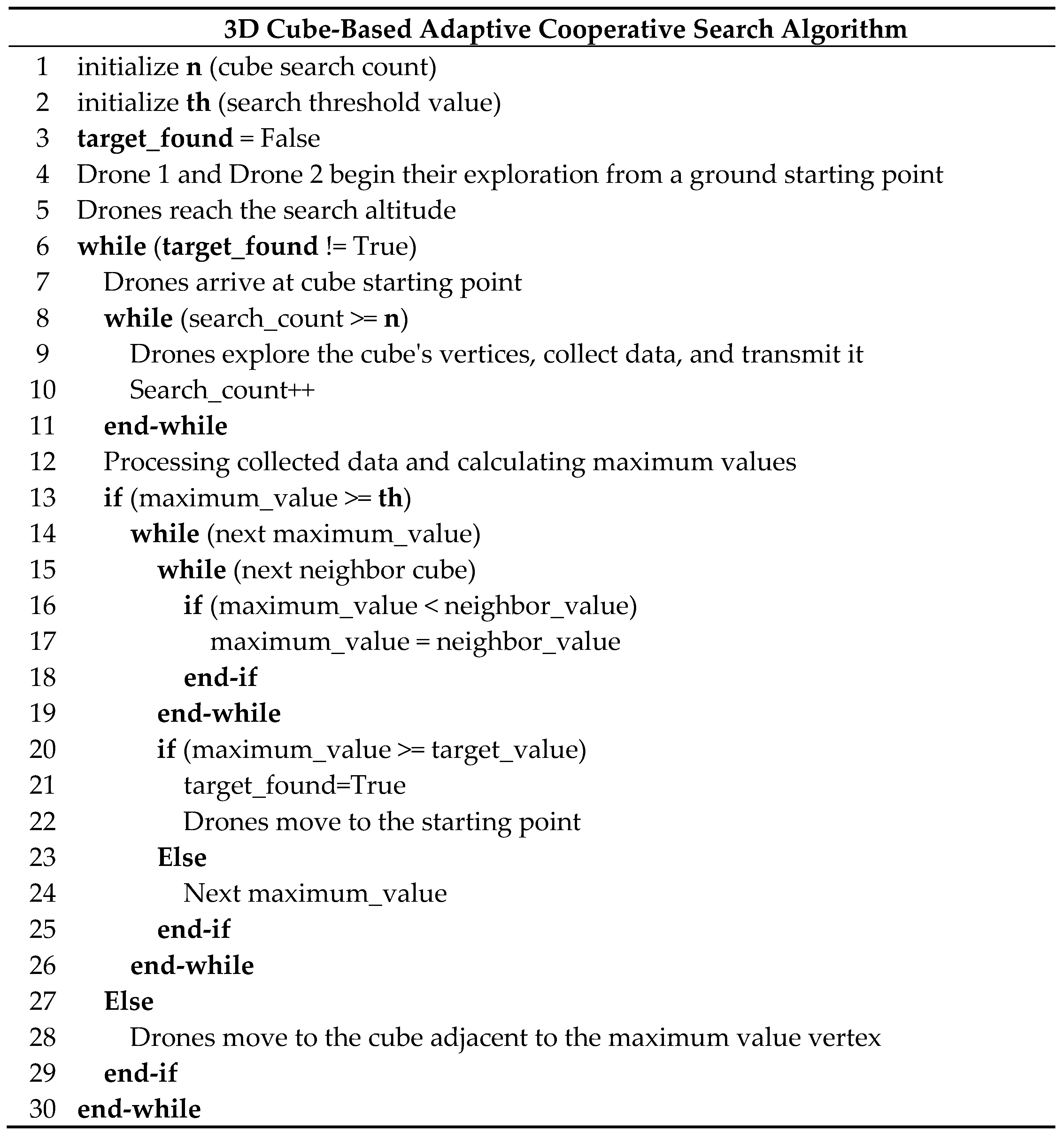
Figure 4.
Simulation environment.
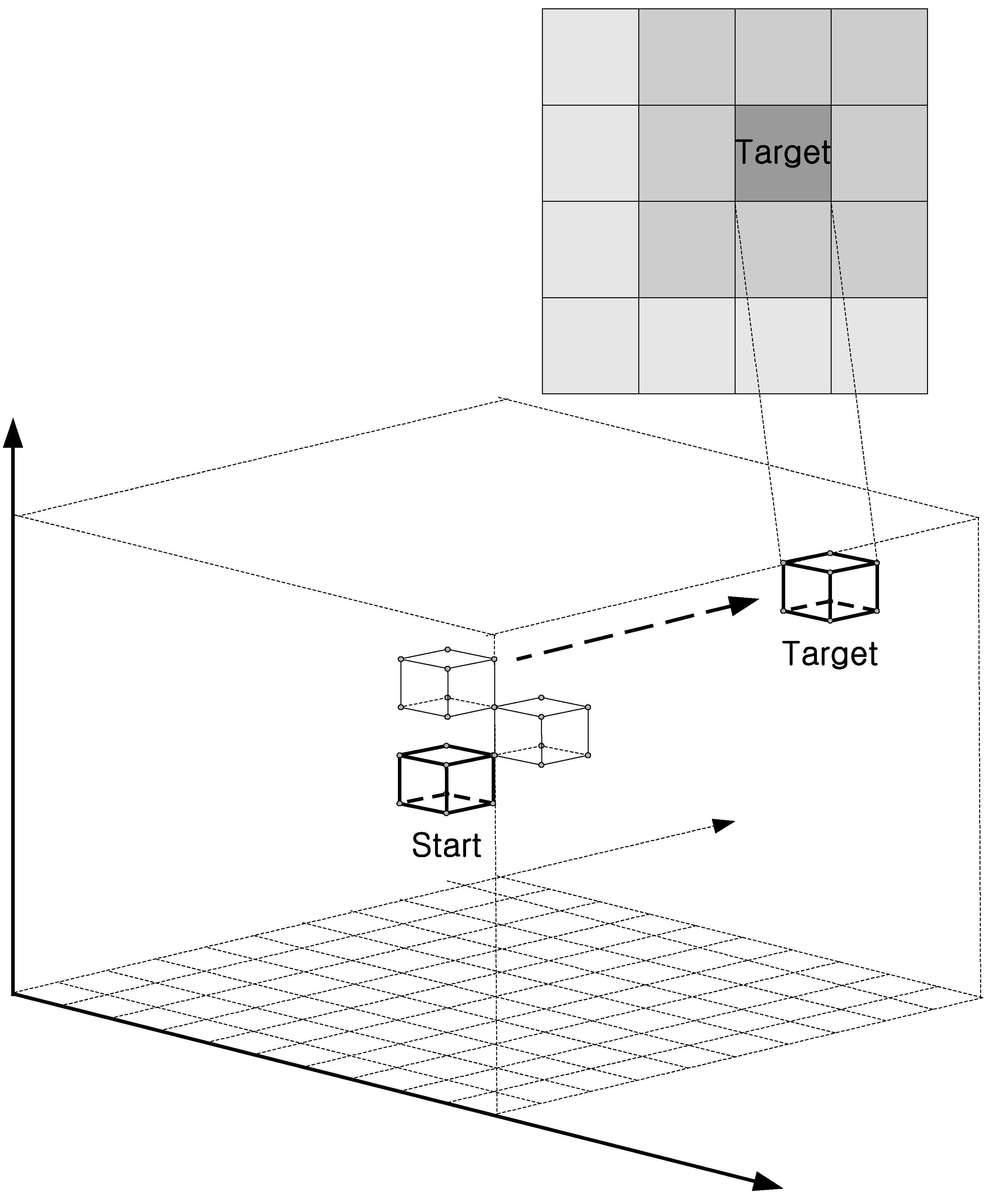
Figure 5.
Total search success for each method.
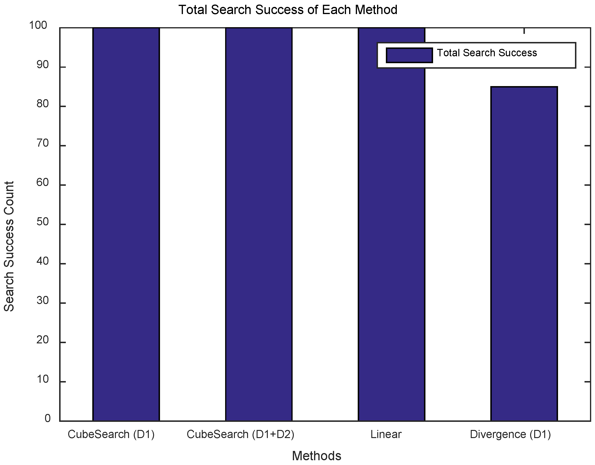
Figure 6.
Search distance for each round.
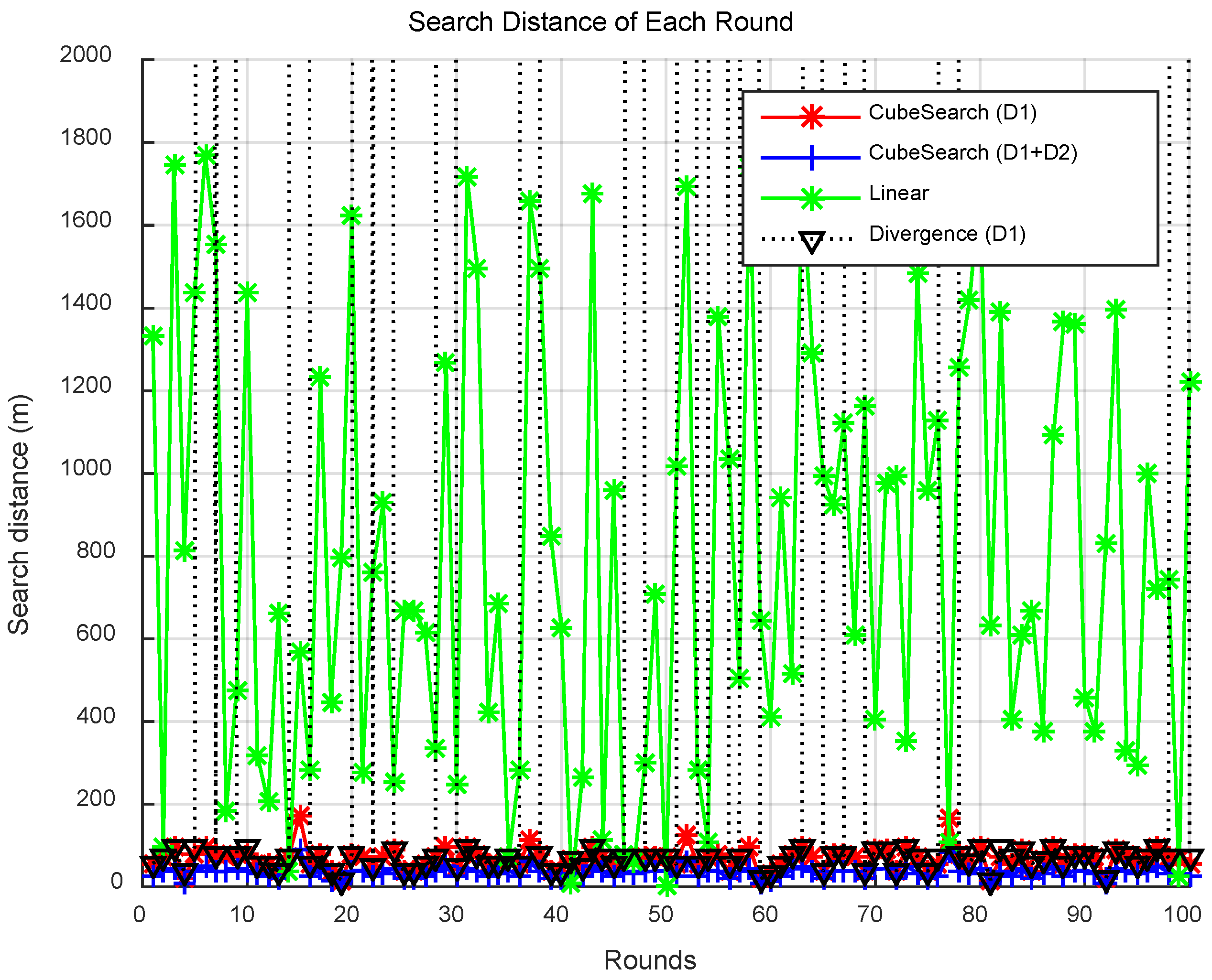
Figure 7.
CPU time for each round.
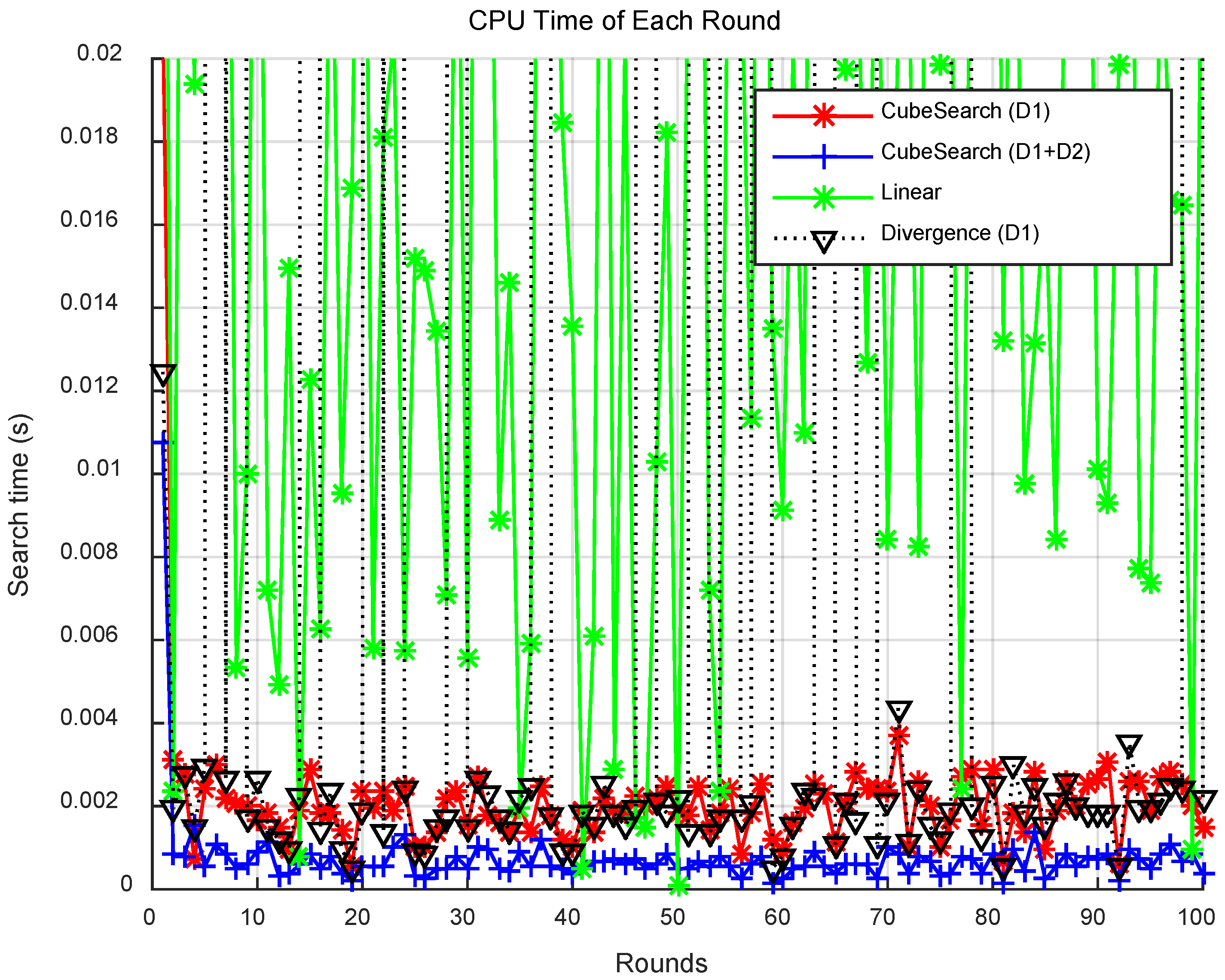
Figure 8.
Total search distance for each round.
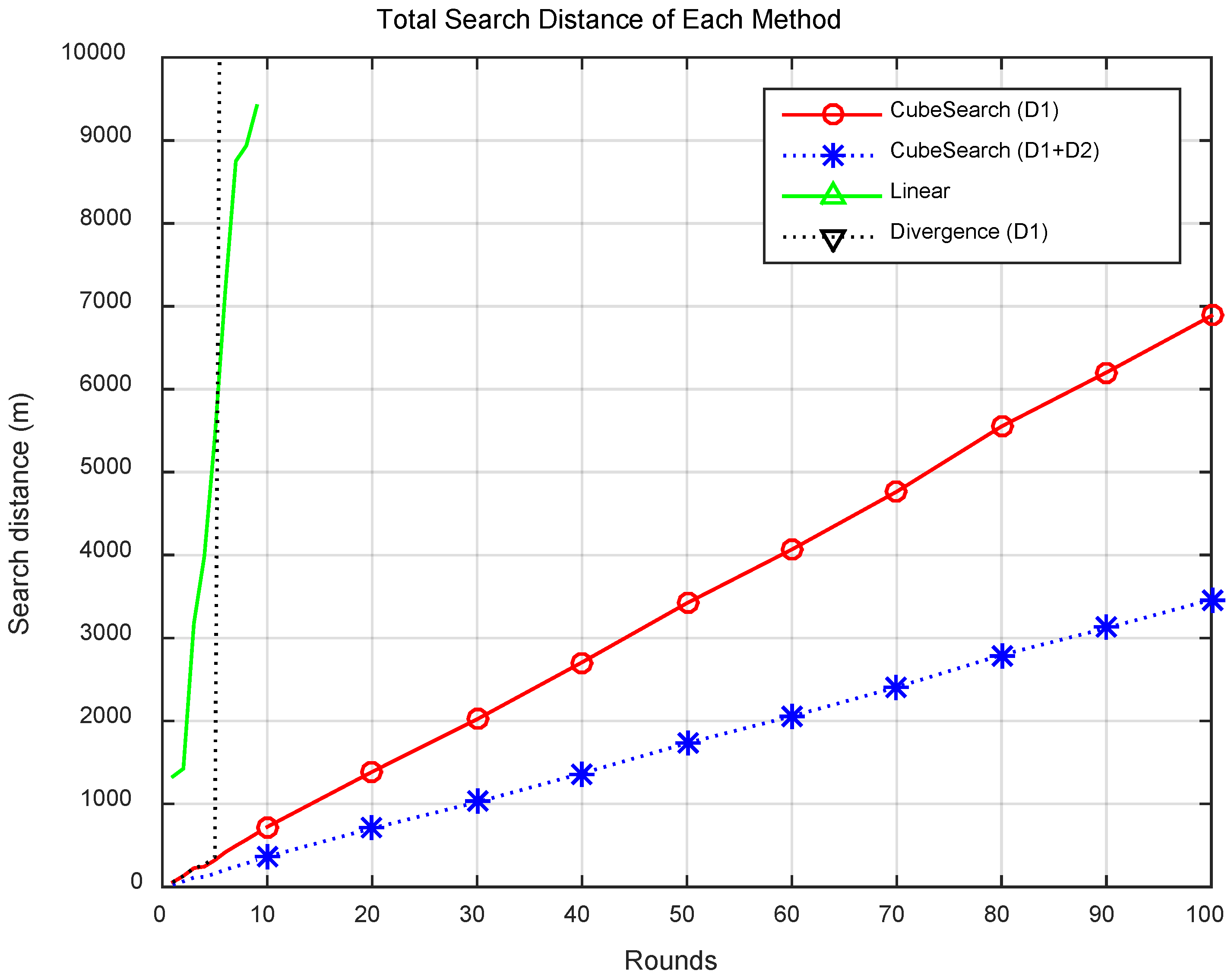
Figure 9.
Total CPU time for each round.
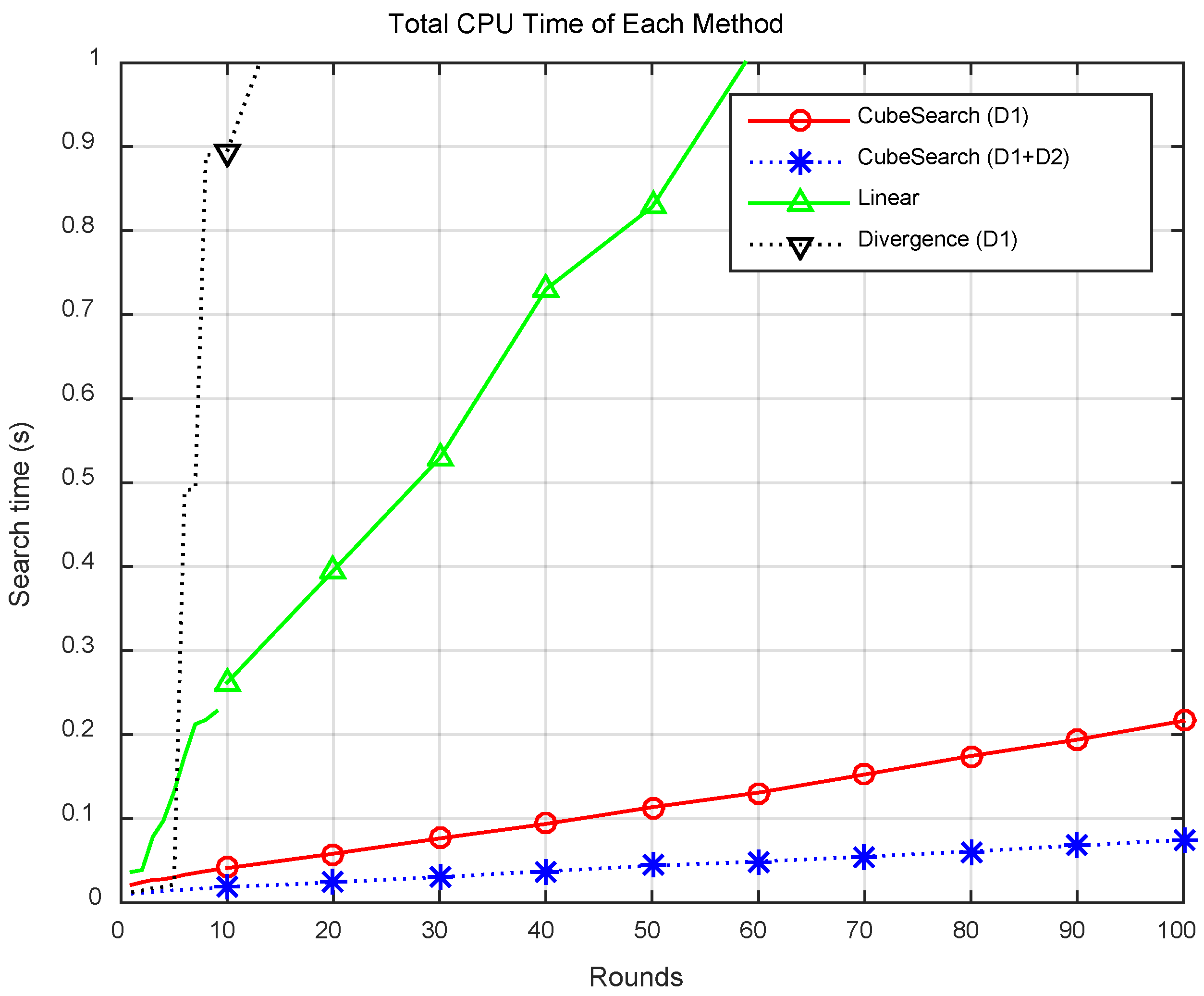
Figure 10.
Comparison of Total CPU Time.
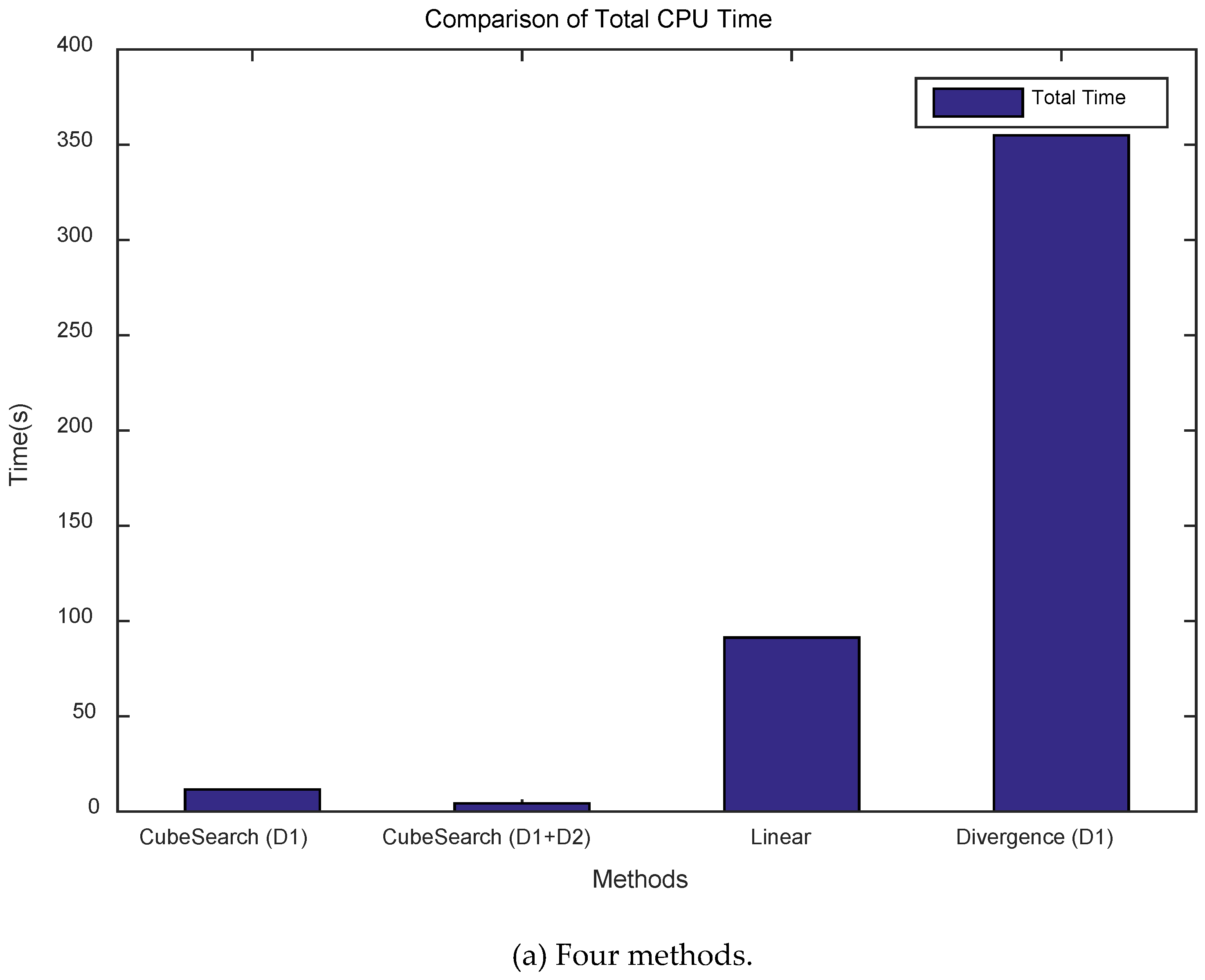
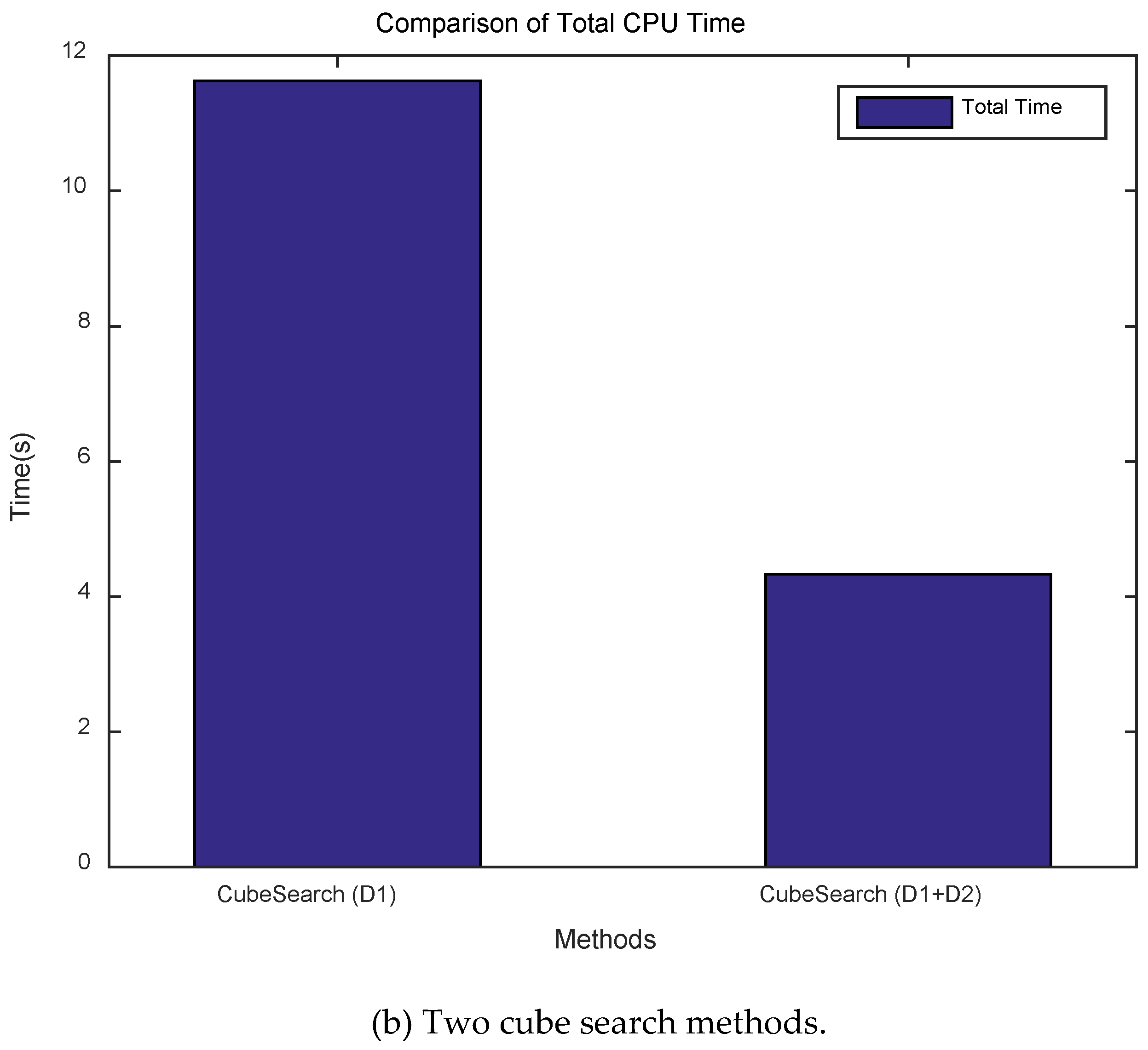
Figure 11.
Comparison of Total Search Distance.
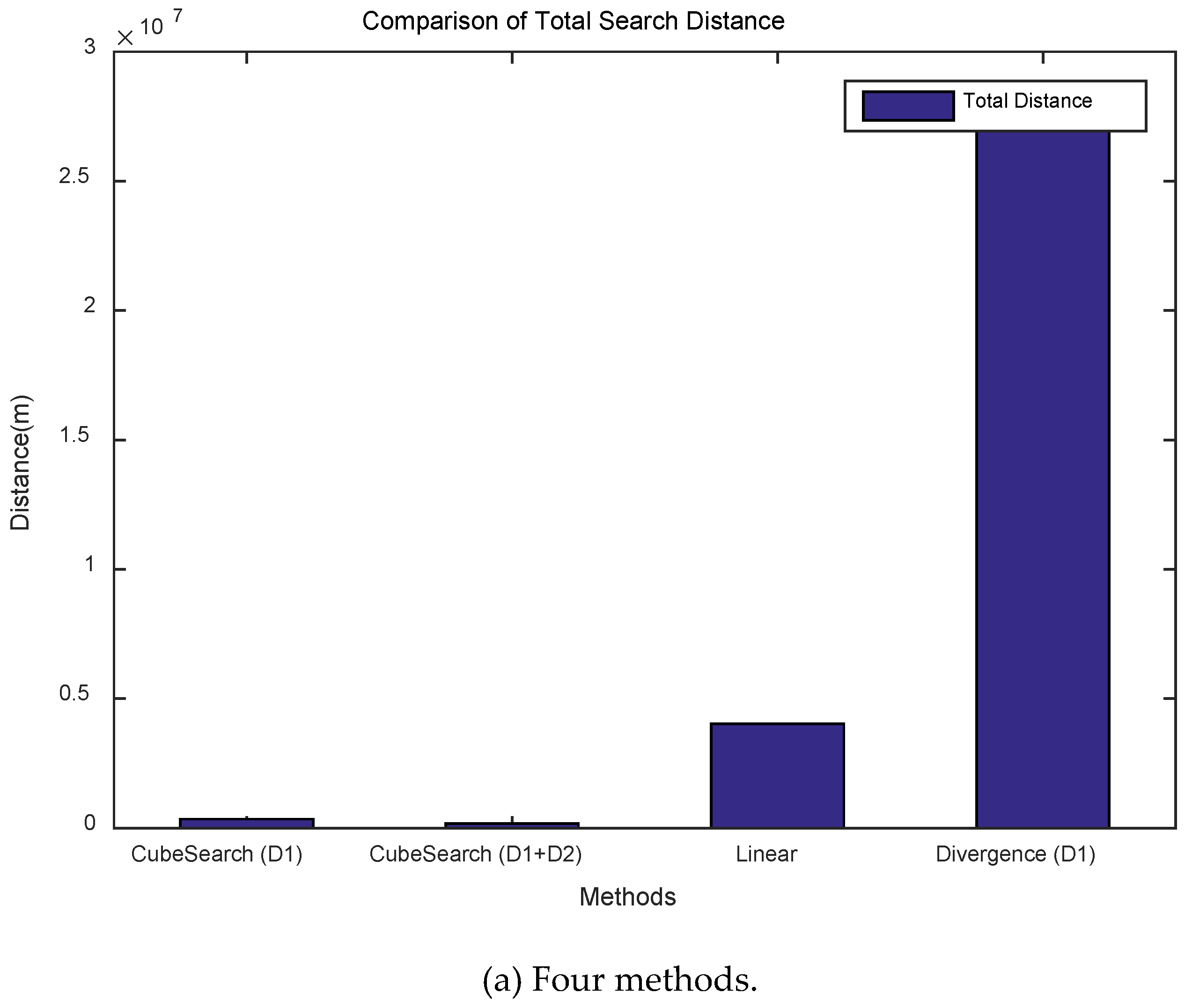
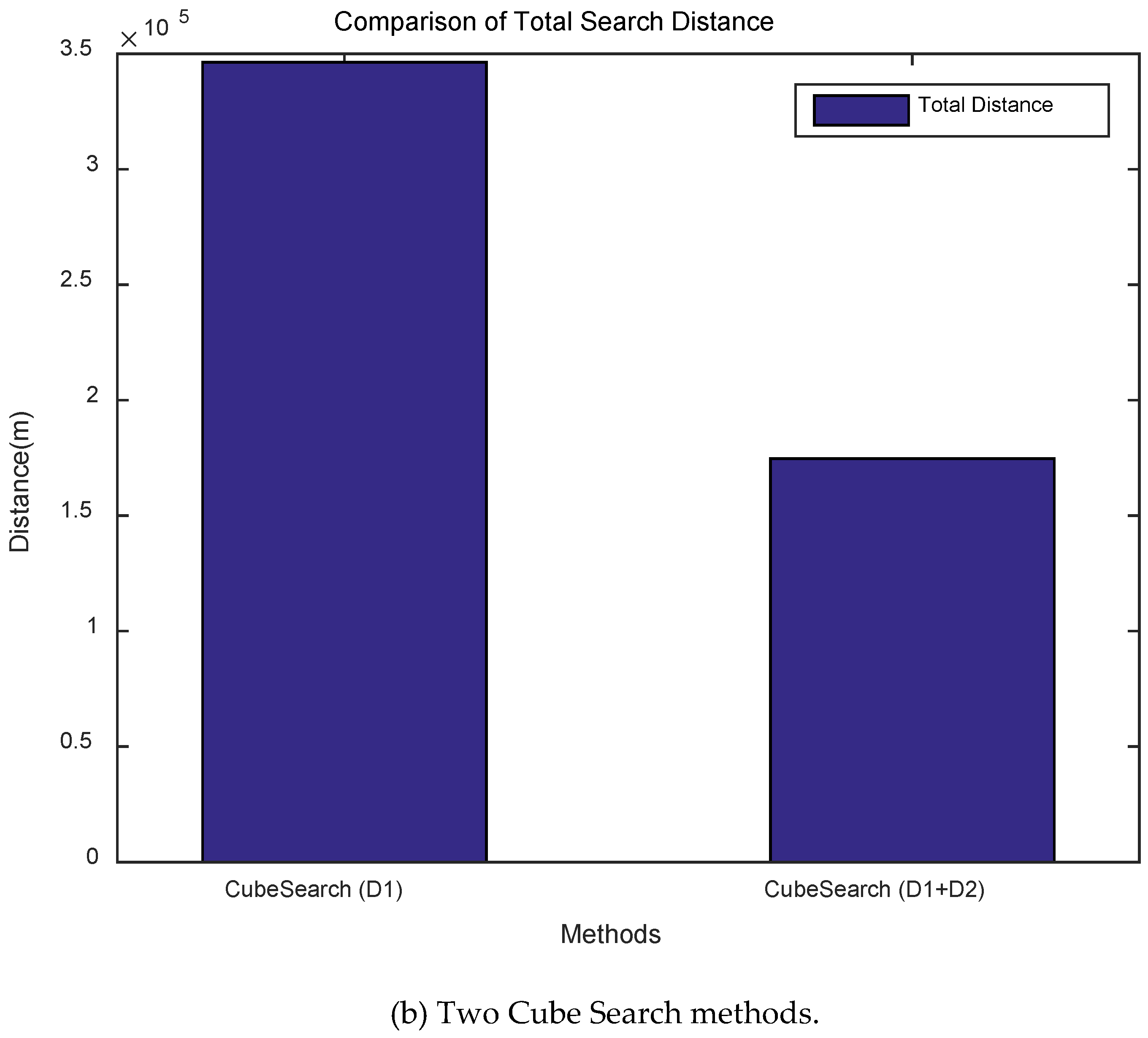
Figure 12.
Total search cube accumulation for each method.
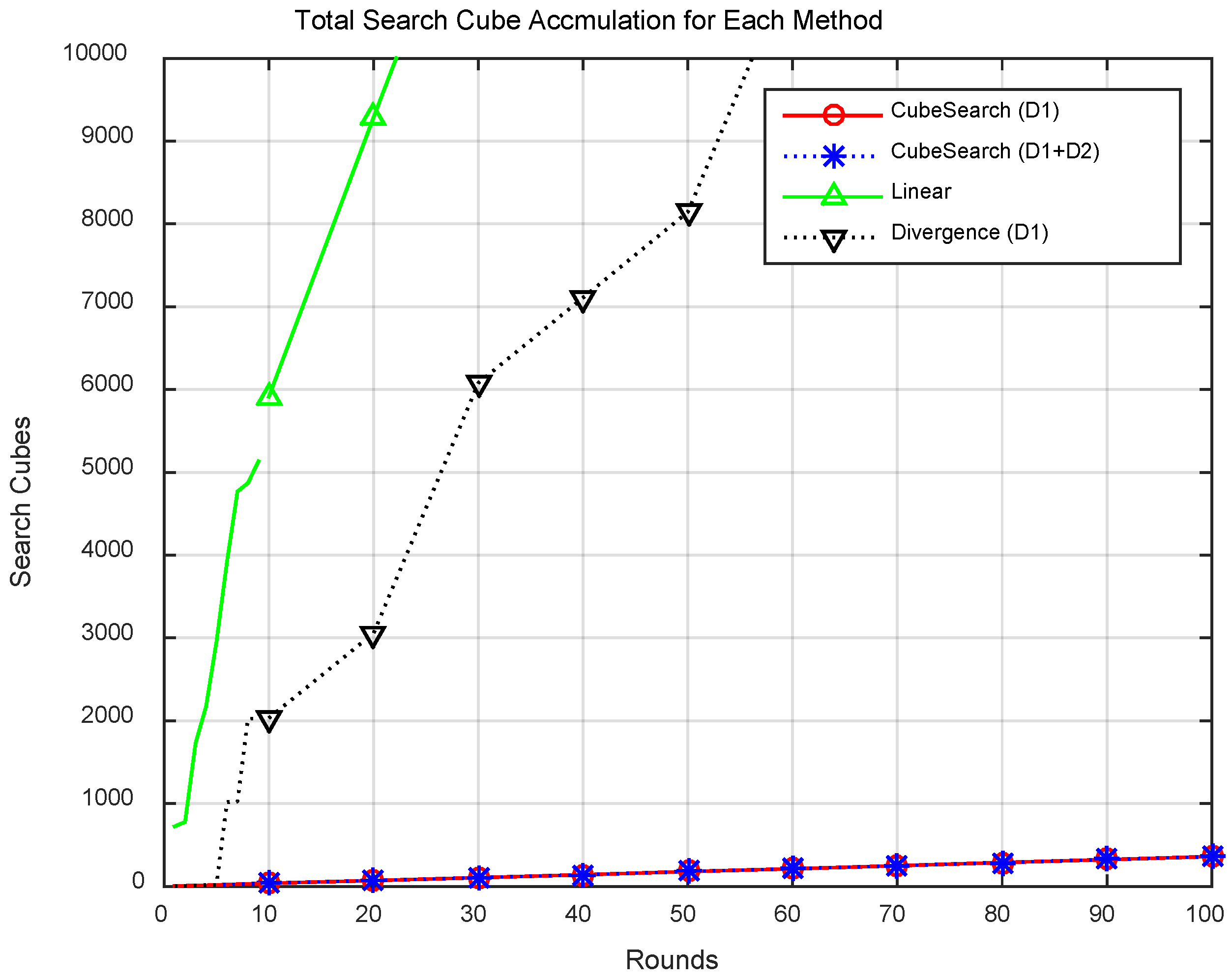
Figure 13.
Total search cubes for each method.
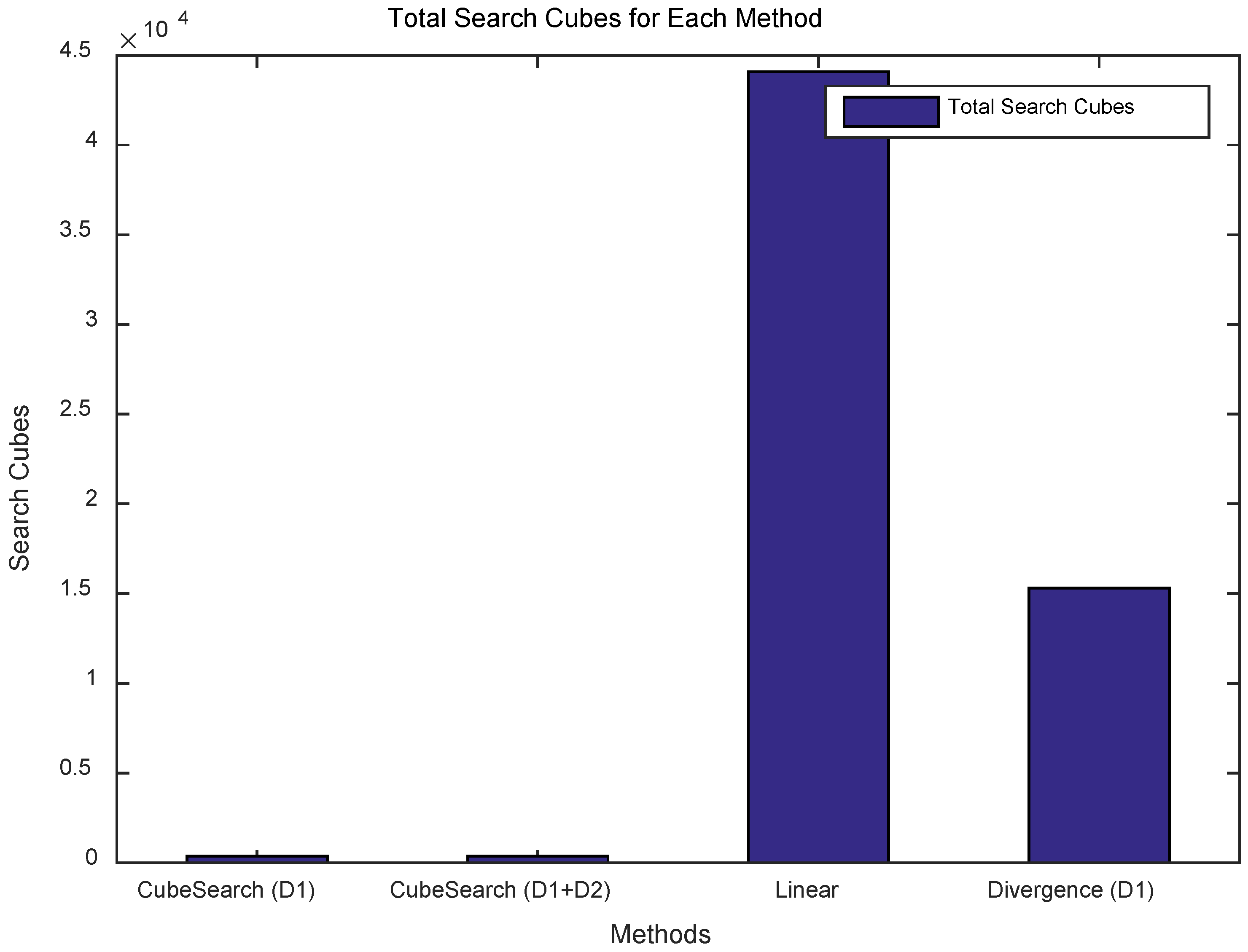
Figure 14.
Drones developed for air pollution exploration through adaptive cooperation.
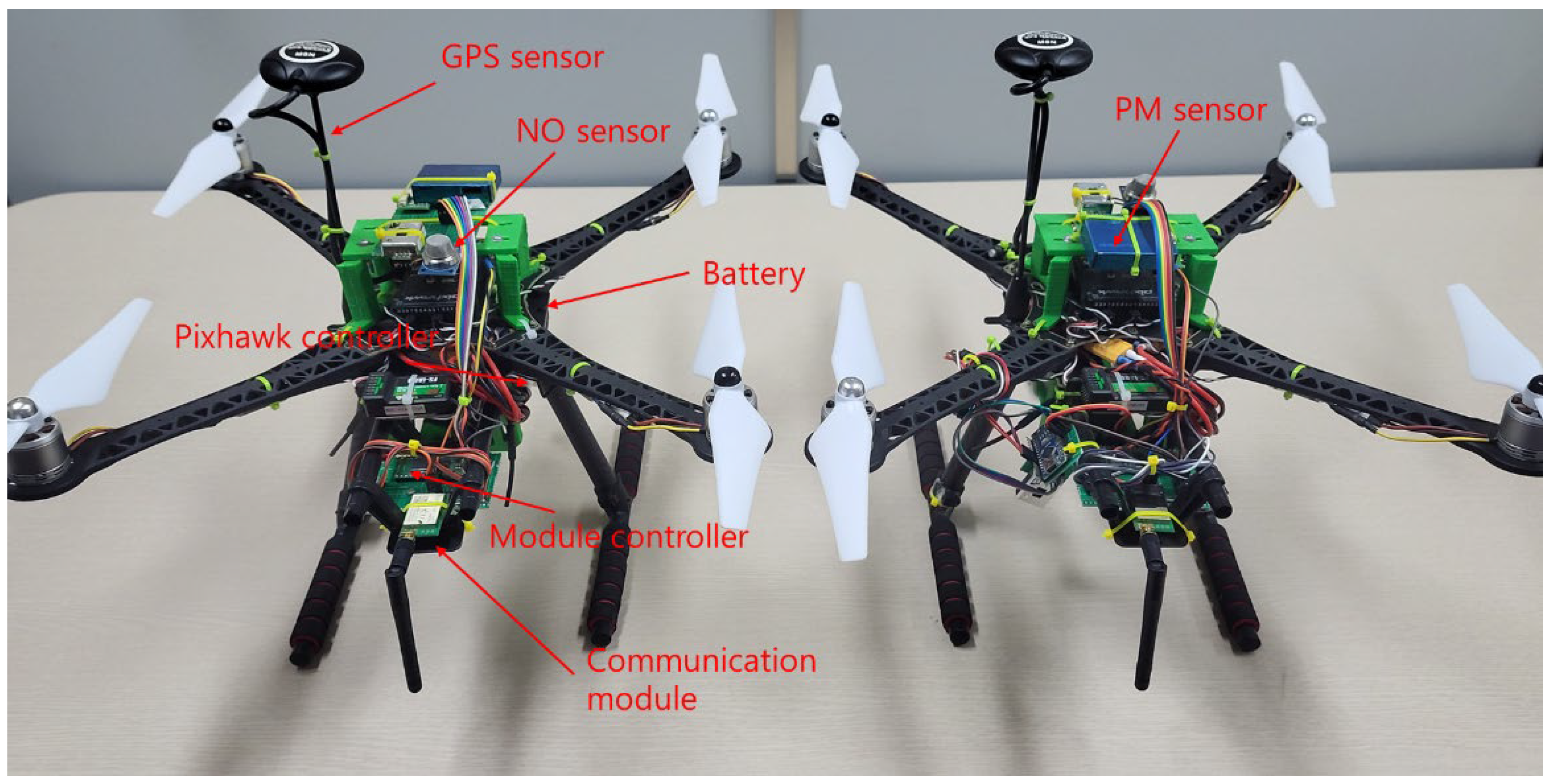
Figure 15.
Collaborative exploration experiment using drones equipped with the proposed algorithm (site1).
Figure 15.
Collaborative exploration experiment using drones equipped with the proposed algorithm (site1).
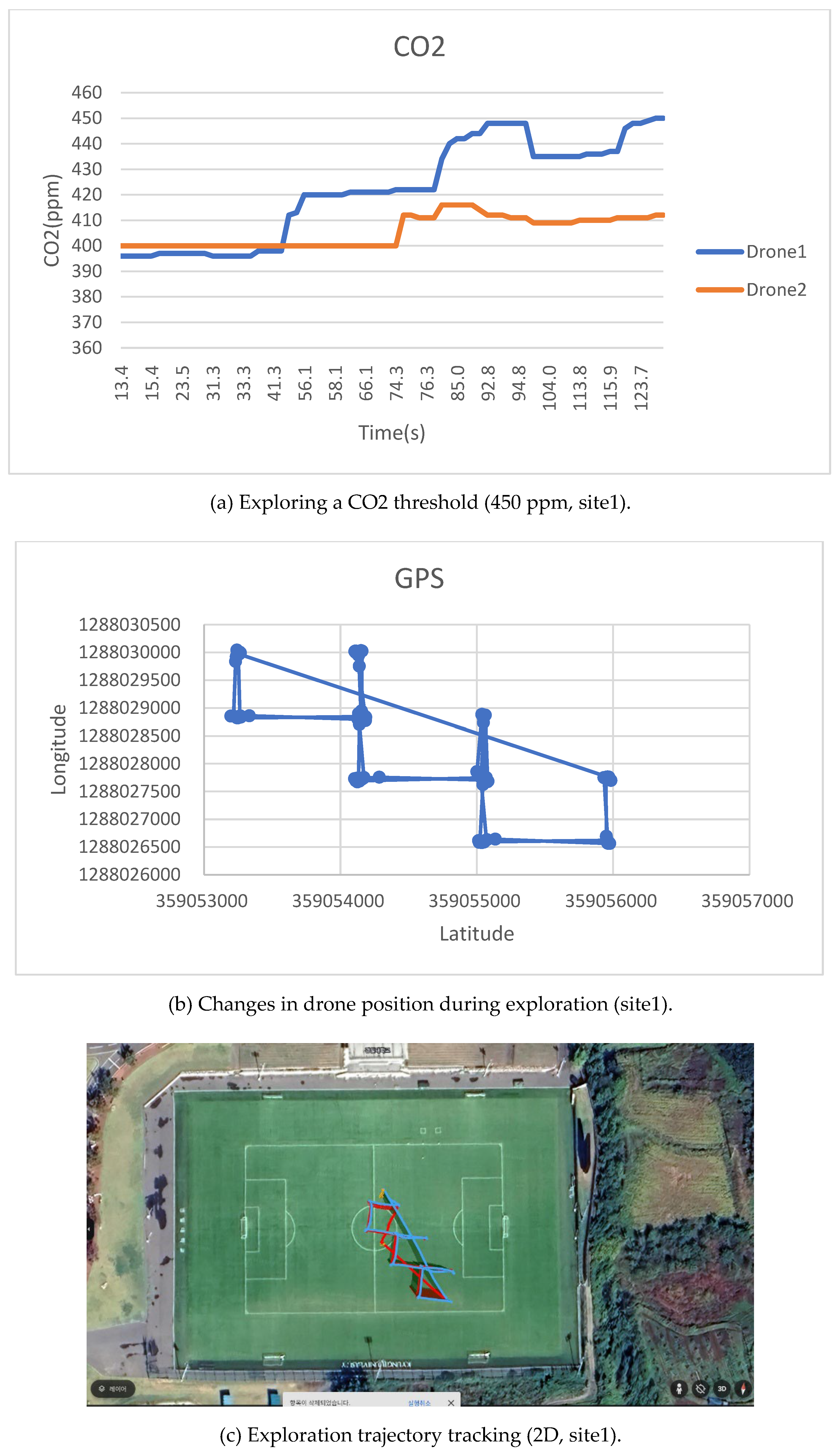
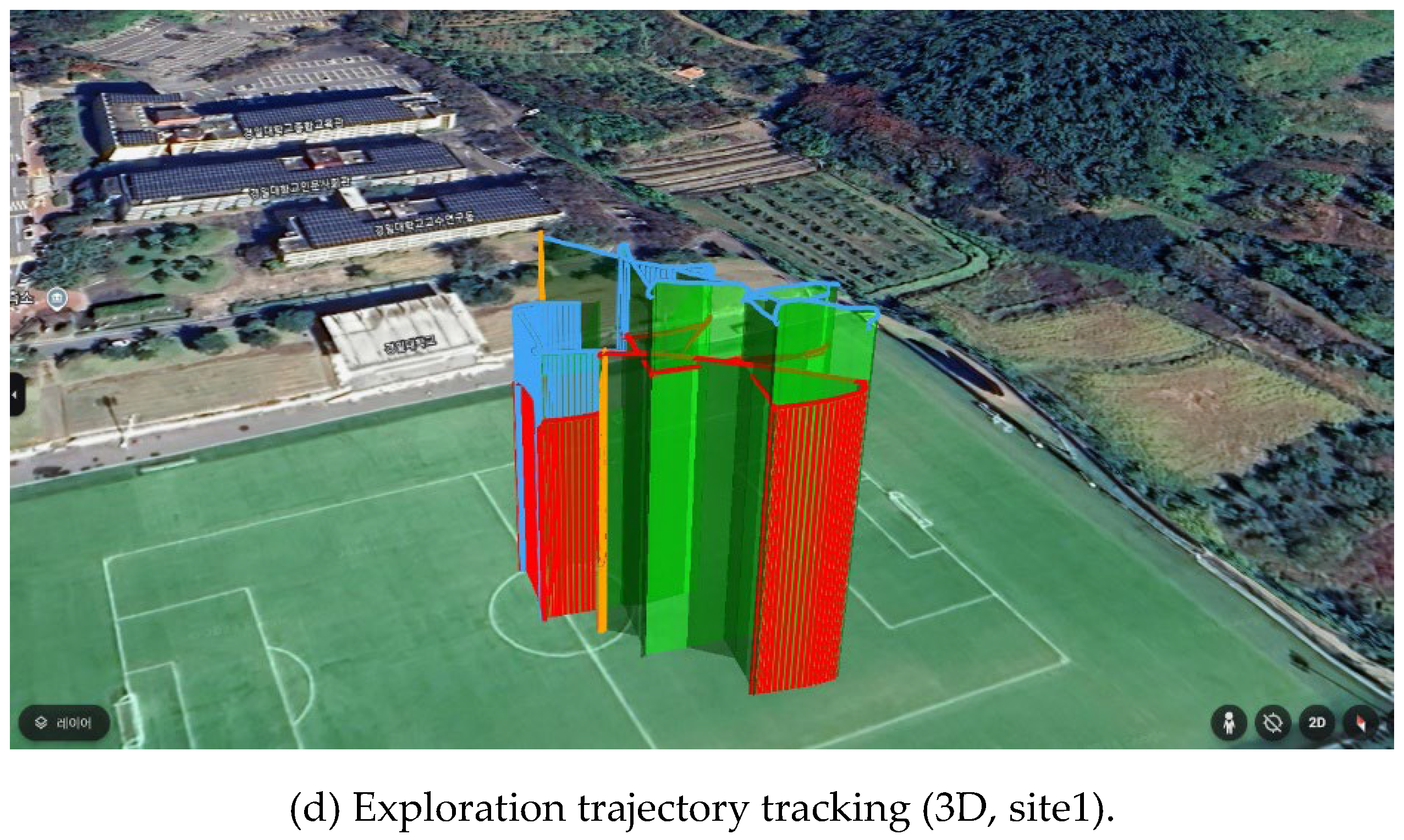
Figure 16.
Collaborative exploration experiment using drones equipped with the proposed algorithm (site2).
Figure 16.
Collaborative exploration experiment using drones equipped with the proposed algorithm (site2).
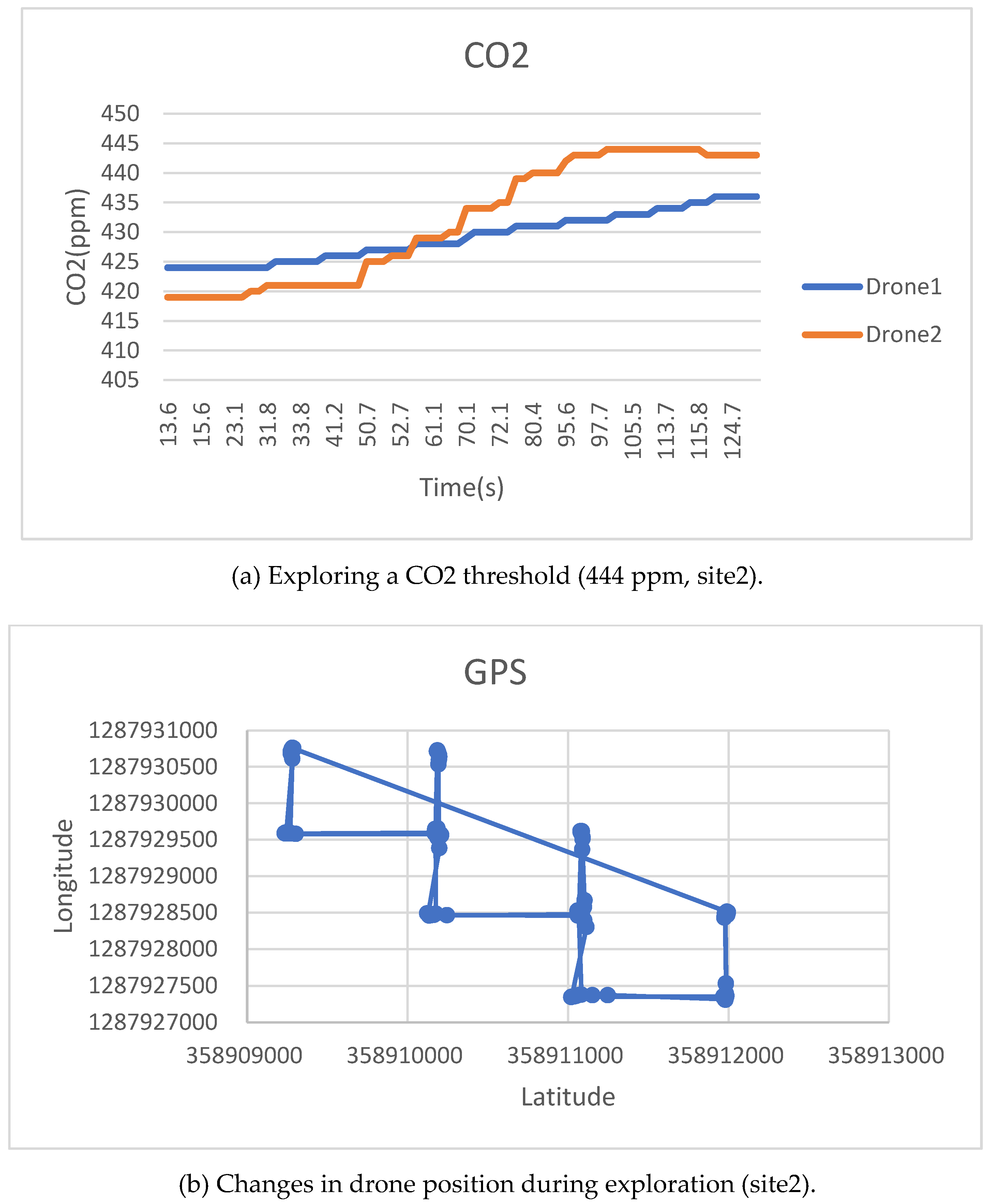
Table 2.
Simulation environment.
| Category | Value |
| Size of search area | 10 × 10 × 10 cells |
| Cell size | 1 × 1 × 1 m |
| Threshold value | 0.9 |
| Target (maximum) value | 1.0 |
| Number of targets | 1 (random) |
| Number of UAVs | 1 and 2 |
| Limitations on navigation rounds | 1000 |
Table 3.
Drone hardware components and specifications.
| Components | Specifications |
| System controller | Raspberry Pi Pico, Dual-Core Arm Cortex-M0+, 133Mhz |
| Communication module | LoRa E22-900M22S |
| PM sensor | pms7003 |
| CO, CO2 sensor | MTP40-F NDIR CO2 sensor |
| Frame | TAROT S500 Quad-Copter frame, Diameter: 500mm, Height: 288mm |
| Motors | S2312-920KV Motor, 23x12mm |
| Propeller | 9x4.5inch Self-Lock Propeller, Universal Rype |
| Flight controller | Pixhawk 2.4.8 32bit |
| GPS sensor | UBlox M8N GPS |
| Battery | PT-B5200N-FX50 (14.8V, 4S1P, 50C+) |
Table 4.
Experimental environment.
| Components | Specifications |
| Number of Drones | 2 quadcopter type drones |
| Experimental Site | Site1. A University playground Site2. Outdoor Open Space |
| Initial Search Altitude | 15m |
| 1 Unit | 10 x 10 x 10m Cube Type |
| Number of Explorations in One Cube | 2 times |
| Maximum Search Altitude | 60m |
| Maximum Search Width | 100m |
Disclaimer/Publisher’s Note: The statements, opinions and data contained in all publications are solely those of the individual author(s) and contributor(s) and not of MDPI and/or the editor(s). MDPI and/or the editor(s) disclaim responsibility for any injury to people or property resulting from any ideas, methods, instructions or products referred to in the content. |
© 2025 by the authors. Licensee MDPI, Basel, Switzerland. This article is an open access article distributed under the terms and conditions of the Creative Commons Attribution (CC BY) license (http://creativecommons.org/licenses/by/4.0/).
Copyright: This open access article is published under a Creative Commons CC BY 4.0 license, which permit the free download, distribution, and reuse, provided that the author and preprint are cited in any reuse.


