Submitted:
11 April 2025
Posted:
14 April 2025
You are already at the latest version
Abstract
Reality often challenges the effectiveness of environmental policy and its instruments, as is evident for Marine Ecological Territory Instruments in the Mexican Coastal Zone (MCZ), known as Ecological Territory Management Programs (POET, from the Spanish acronym). The primary function of POETs is to guide the allocation of coastal uses within the ecosystem boundaries of 265 municipalities, encompassing 24,945 km of coastline and 10,570 km2 of the continental shelf. The POETs operate through a public management system involving over 500 legal instruments and at least 300 personnel, comprising both municipal and state officials. Its goal is to protect the rights of more than 25 million inhabitants to enjoy a healthy environment and equitable access to resources. However, this remains a challenging and often unresolved task partially explained by various adverse and complex operational conditions that include the diverse population distributions among coastal municipalities, which average 96528.8 ± 203842.5; inaccuracies in coastline measurements, and the absence of a unified system for monitoring, collecting, and disseminating coastal data. Considering operability as an important POETs characteristic that enable them to activate other functions, we identify 47 essential conditions for effectively operating marine POETs within the Mexican Coastal Zone management public system.
Keywords:
Coastal Management
; Marine spatial planning
; Mexican Coastal Zone
; Marine Ecological Territory Instruments
1. Introduction
Coasts are settings whose particularly complex structures and dynamics often make it difficult for environmental management instruments to function, reducing their effectiveness in accomplishing environmental management objectives. For this reason, we analyze the influence of three territorial dimensions of the Mexican Coastal Zone (MCZ) on the operation of spatial planning instruments in its marine category.
Coastal management often challenges the achievement of an adequate design and application of environmental policy and its instruments that, based on results, demonstrate their effectiveness as a binding tool between the development of an environmental policy, the decision-making process, and its implementation. Based on the Mexican legal framework, this implies demonstrating that its environmental policy instruments guarantee the right to a healthy environment and promote distributive justice, the latter understood as the delivery, through different titles, of the domain of the national assets to individuals, for the common good, the good of all and the development of the community.
Ecological Territory Management (ETM) in Mexico is as policy instrument that regulates and guides land use and productive activities in the Mexican public environmental management model. This framework is established in the General Law on Ecological Balance and Environmental Protection (Ley General del Equilibrio Ecológico y Protección al Ambiente, or LGEEPA, for its acronym in Spanish) [1], which is a key legal element of environmental regulations, second only to the Mexican Constitution [2]. It is compatible with the conceptual framework of Marine Spatial Planning promoted by UNESCO [3] and shares functional similarities with the General Planning Guidelines of the state of California in the USA [4] and the Maritime Spatial Planning Plans of Spain [5,6].
ETM's primary goal is to protect the environment, preserve ecosystems, and promote the sustainable use of natural resources. Operators must accomplish this by orienting the spatial distribution of productive activities based on ecological criteria derived from analyzing trends of environmental degradation and available resources. As a result, ETM's functions as a tool for territorial regulation and planning [1,7,8]. The implementation materializes through documents known as Ecological Territory Management Programs (POET, from the Spanish acronym) that outline ecological guidelines and criteria that should govern the placement of land use and productive activities to prevent environmental conflicts and risk scenarios in a specific territory [7,9,10,11]. While these programs were introduced nationwide in the 1990s, the environmental conditions in different regions of Mexico that operate under a POET highlight that achieving effective implementation continues to be a significant challenge, particularly in coastal areas [12,13,14].
A POET has four categories: general territory, regional, local, and marine. While none of these categories are specific to coastal areas, all have the potential to influence such regions, specifically for some regional and local programs that affect states or municipalities with coastlines [1,15,16]. Among these, the marine category is the most closely associated with coastal areas, as it applies, although not exclusively, to federal zones adjacent to marine regions, such as the Federal Maritime-Terrestrial Zone and nearshore areas [16,17,18].
By 2017, Mexico had established two marine POETs: the Gulf of California, created in 2006 [19], and the Gulf of Mexico and Caribbean Sea, established in 2012 [20]. In 2018, the North Pacific Marine POET was enacted [21] Later that same year, Mexico issued the National Policy on Seas and Coasts [22]. Six years after that last issuance, we observed that even in coastal areas governed by a marine POET, significant trends of environmental degradation persist, such as the creation of risk scenarios driven by unsustainable patterns of location of activities and land use, as well as the persistent push for fragmented sectoral projects and developments that often contradict ecological planning policies [22,23,24,25,26,27,28]. Also, there is an ongoing trend towards fragmented projects and developments that often clash with ecological planning policies [8,29,30].
We propose that the evaluation of the effectiveness of a POET should consider how Environmental Territorial Management functions as a regulatory and planning tool within a public environmental management system that operates under varying often adverse conditions. By focusing our analysis on the geographic characteristics of coastal zones that are regulated by a marine POET—considering their biophysical, social, economic, political, and legal-administrative aspects—we can examine, within a logical framework of necessary conditions, which of these specific characteristics of coastal zones influence the effectiveness of marine POETs.
We live in an interconnected world where seas and coasts are natural resources whose materials, energy, and information transcend political boundaries. As a result, decisions regarding the use of marine waters and coastal areas impact not only one nation but can also lead to humanitarian issues in some cases. Countries must collaborate to uphold environmental health and social well-being beyond their borders while respecting their sovereignty [31]. Although this work primarily focuses on a national case, its insights might be applicable beyond Mexico's borders.
2. Materials and Methods
2.1. Problem Definition
Our research question is: How does the geographical context of a marine Ecological Territory Management Program affect its operability? This question stems from the lead author's experience as an environmental manager during the first ten years of professional practice. It became clear that, despite the Mexican state implementing ecological territory management, in some cases there was no evident improvement in the environmental health or well-being of the coastal population.
2.2. Adaptation to Research Conditions
Adapting to the operational conditions of the research project was crucial for providing a realistic understanding of managing coastal spaces in a remote area. This work is part of a doctoral research project in Geography that began in 2010, focusing on the practical application of ecological land management tools.
The first two years of research took place in a metropolitan area. However, a significant event drastically changed the first author's circumstances, shifting the project's development site to a small, marginalized coastal village. These new conditions severely restricted access to information, necessitating considerable efforts to gather data through colleagues and occasional visits to cities with better internet access where we conducted the documentary research on the characteristics of the Mexican coastal area using the Mozilla Fire Fox browser and the Duck Duck Go and Chromium search engines.
These challenges reflect the operational realities faced by several coastal municipalities in Mexico, creating an adaptive challenge that profoundly influenced the research's insights and outcomes.
2.3. Delimitation of the Study Area as an Operational Context
Our analysis focuses on the Mexican Coastal Zone that is affected or regulated by marine POETs. The MCZ is a legal designation defined in the National Policy of Mexican Coastal Seas [22]. This designation distinguishes a specific area characterized by significant interactions between the sea, land, and atmosphere. It comprises a continental section, a marine section, and an insular section.
2.4. Definition of the Operability Variable
We define operability as an analytical category of ecological land management instruments. Various operational analysis approaches aim to determine effectiveness by comparing expected results with actual outcomes [33,34]. Objects have characteristics that enable them to activate other functions. In ecological land-use planning for coastal management, effectiveness depends on features that support practical application. These programs help prevent and address environmental conflicts by organizing human activities within a territory based on ecological principles.
2.5. Analysis of the Operability of Marine POETs
Using a reflexive approach based on experience and a logical framework of necessary but not sufficient conditions, we offer a checklist to analyze the operability of a marine POET considering that it depends on the biophysical, political-legal-administrative, and socioeconomic conditions of the scenario conditions of the scenario in which it operates (Figure 1). The "necessary but not sufficient" causality framework highlights that while condition "X" is essential for event "Y" to occur, "X" alone does not guarantee that "Y" will occur [35].
3. Results
3.1. Subsection Problem Definition
There is documented evidence that marine POETs do not have the expected impact on public policies and private sector decision-making regarding the use of the MCZ since even in portions subject to these instruments, new environmental conflicts and risk scenarios remain and are being generated, caused by inadequate occupation patterns, which foster environmental conflicts and environmental vulnerability of resident coastal populations, compromising their right to a healthy environment and the achievement of distributive justice [23,24,25]. This situation highlights the operational problems of marine POETs, which we analyze as dysfunctions influenced by the geographical context given by the biophysical, political-legal-administrative, and socioeconomic characteristics.
3.2. The Mexican Coastal Zone Context as Operative Condition
The MCZ is a formal region of the national territory established in 2018 in the National Policy of Seas and Coast of Mexico. It is an intellectual interpretation of an assembly of physical-natural elements and political-administrative divisions linked by the coastline. It describes a geographical space where the marine environment, terrestrial environment, and atmosphere interact consisting of the following components: a) a continental portion made up of 265 coastal municipalities—150 of which have beach fronts, while 114 do not have direct access to the sea but still experience high to medium coastal influence, such as coastal vegetation; b) a marine portion that extends from the continental shelf, limited by the 200-meter isobath and; c) an insular portion comprising the national islands. Its penetration into the sea varies, ranging from less than two kilometers in some areas of Baja California Sur or Oaxaca to more than 270 kilometers off the Yucatan Peninsula (Figure 2).
According to the data available in the Digital Geographic Atlas of Mexico 2015 [26], 62.4% of Mexico's marine territory was subject to a marine POET. This type of instrument governs seven Mexican ecoregions: the Gulf of California (subject to the Gulf of California POET since 2006), Northern Gulf of Mexico, Southern Gulf of Mexico and Caribbean Sea (subject to the Gulf of Mexico and Caribbean Sea POET since 2012), and Southern Californian Pacific and Monterey Transitional Pacific (subject to the Northern Pacific POET since 2018), covering an area of 1,969,677.28 km2 (see Table 1). However, only the Gulf of Mexico POET encompasses the terrestrial portion of the MCZ completely, as it includes the coastal municipalities within its territorial scope. In contrast, the North Pacific POET covers only a 20 km strip extending inland from the coastline, and the Gulf of California POET does not include any terrestrial areas of the MCZ (Table 1).
3.3. Operability as an Analytical Category
In simple terms, "operability" refers to the characteristics of objects or instruments that enable them to activate other functions. Various operational analysis approaches exist in different fields; some are retrospective methods that assess whether a system or process operates effectively by comparing expected results with actual outcomes [33,34]. Some analyze a priori, anticipating the possible results [35]. Both retrospective and prospective operability analysis approaches help to evaluate and improve an instrument's performance.
Evaluating the effectiveness of an abstract legal instrument like a marine POET is complex because its mechanisms are intangible, and the results are not easily identifiable at first glance. A POET's outcomes may take years or even decades, making it challenging to compare real-world results—such as territorial occupation, environmental health, and distributive justice—with the ideal models outlined in the POET.
Moreover, assessing the effectiveness of a POET based on its outcomes might require waiting for an environmental disaster or conflict to occur, which is unacceptable from a humanitarian perspective. In such a way, a preoperative approach is convenient for increasing its effectiveness by anticipating dysfunctional problems and ensuring the instruments have the necessary working conditions to succeed, but it isn't always feasible.
3.4. Analysis of Operational Conditions of Marine POETs in the MCZ
3.4.1 Operational Essential Conditions
When a POET governs an area, the agencies responsible for approving, denying, or imposing conditions on land or natural resource use must base their decisions on the ecological guidelines and criteria established in the program. This process requires a technical evaluation that supports the decisions made by public officials, where they should explain whether the proposed changes will significantly alter the intended condition of the management unit according to the ecological criteria of the POET, determining if the proposed use or activity violates these guidelines. However, the issuance of this technical opinion depends not only on the existence of the POET but also on the operational conditions under which public officials utilize this instrument.
Based on the information available on Mexican Federal Public Administration [37] the POET operates through a public management system with over 500 legal elements and at least 300 operators including municipal and state officials. Its goal to safeguard the rights of more than 21 million inhabitants to enjoy a healthy environment and fair access to resources is an ongoing and often pending task.
According to our experience of more than 20 years in coastal environmental management as consultants, governmental technical official at municipal level, and as academics, we have identified 47 essential conditions for effectively operating marine POETs within the Mexican Coastal Zone management public system (see Table 2).
Our primary goal is to identify essential conditions for operators at all three levels of government—municipal, state, and federal— to successfully manage the spatial distribution of productive activities through the marine POET application. That management involves implementing land use and aquatic resource regulations based on the guidelines established by the POET framework and its ecological criteria. The result is the list in Table 2, Table 3 and Table 4.
Of the 47 necessary conditions identified, 25 fall under municipal jurisdiction, 11 are under state jurisdiction, and 11 are under federal scope. Most changes in land use within the continental portion of MCZ are regulated mainly at the municipal level. In contrast, the federal government is responsible for overseeing the use of maritime waters, adjacent federal zones, and island territories. For its part, the state government plays a more significant role in promoting economic activities, which means its involvement in land use changes and natural resource management focuses on planning and promoting economic and social development.
While our list is not exhaustive, it serves as a starting point for constructing an operative organization-evaluation tool at each level of government and as a guide to elaborate recommendations of MCZ management through the marine POET framework takin in to account that the primary function of a marine POET in the MCZ is to guide the location of coastal uses within ecosystem limits across more than 265 municipalities, 24,945 km² of coastline, and 10,570 km² of continental shelf. A POET operates through a complex public management system with over 500 legal elements, including the Mexican Constitution, regulatory laws, regulations and rules, and at least 300 operators [37,38], including municipal and state officials. Each essential condition identified may or may not be present in a specific management scenario along the MCZ., therefore, operators navigate in a variety of physical, social, economic, and administrative conditions that can lead to differing levels of success or even failure as shown below.
3.4.2. Demographic Dimensions
According to the provisions of the Mexican Constitution, [2] municipalities are directly responsible for essential services, which include (a) potable water, drainage, sewerage, and wastewater treatment and disposal; (b) public lighting; (c) waste management, encompassing cleaning, collection, transfer, treatment, and final disposal; (d) markets and central supply centers; (e) cemeteries; (f) slaughterhouses; (g) streets, parks, gardens, and their maintenance; and (h) public safety.
These responsibilities position municipal governments as the closest entities to both the territory and the people they serve. However, despite their importance, municipalities may not always possess the necessary capabilities to manage these duties effectively.
We found that MCZ municipalities are very heterogeneous in demographic terms, which is part of the operational conditions to deal with at the municipal level. The land use demand in MCZ must cover the abovementioned necessities for a population of 25,676,661 persons, representing 20% of the country's population (this was calculated using data from the 2020 Population and Housing Census [39]. The population distribution is heterogeneous among the coastal municipalities, with a mean of 96528.8±203842.5, and a range that oscillates from 938 inhabitants in San José Estancia Oaxaca to 1 922 523 in Tijuana, Baja California.

Table 5.
Essential Mexican Coastal Zone Population based on 2020 Population and Housing Census [39].
Table 5.
Essential Mexican Coastal Zone Population based on 2020 Population and Housing Census [39].
| Coastal states | Municipality | Coastal population | |||
| State | Coastal | % | 2020 | ||
| 1 | Baja California | 7 | 6 | 86 | 3769020 |
| 2 | Baja California Sur | 5 | 5 | 100 | 798447 |
| 3 | Sonora | 72 | 14 | 19 | 2109304 |
| 4 | Sinaloa | 20 | 10 | 50 | 2661190 |
| 5 | Nayarit | 20 | 8 | 40 | 538565 |
| 6 | Jalisco | 125 | 5 | 4 | 936089 |
| 7 | Colima | 10 | 3 | 30 | 334962 |
| 8 | Michoacán | 113 | 3 | 3 | 237701 |
| 9 | Guerrero | 85 | 16 | 19 | 1358340 |
| 10 | Oaxaca | 570 | 41 | 7 | 836833 |
| 11 | Chiapas | 124 | 12 | 10 | 790905 |
| 12 | Tamaulipas | 43 | 7 | 16 | 1419067 |
| 13 | Veracruz | 212 | 56 | 26 | 3404748 |
| 14 | Tabasco | 17 | 13 | 76 | 2195916 |
| 15 | Campeche | 13 | 9 | 69 | 839212 |
| 16 | Yucatán | 106 | 51 | 48 | 1737093 |
| 17 | Quintana Roo | 11 | 7 | 64 | 1703424 |
| Total | 1553 | 266 | 17 | 25670816 | |
3.4.2. Coastline Dimensions
According to the information consulted [40] only 59.4% of MCZ municipalities have direct beach access, while the remaining 40.6%, which lack beachfront, are still classified as coastal due to their proximity to the shoreline, which significantly influences their development. The 158 coastal municipalities face significant land use pressures, especially in near-shore areas, from activities dependent on the coastal environment, such as beach tourism, fishing, aquaculture and port facilities, as reported in Mexico's National Policy on Seas and Coasts.
To effectively manage the pressure on beachfront areas, municipalities must collaborate with the federal government, which oversees the federal zone adjacent to the beach, known as the Maritime Terrestrial Federal Zone (Zona Federal Marítimo Terrestre in spanish) - a narrow 20-meter strip of land owned by the nation that cannot be privately owned- [18]. That zone is under constant pressure from real estate investors, tourism, fisheries, aquaculture, and port development, and it became ungoverned when municipalities and federal agencies fail to coordinate effectively. Although a marine POET establishes specific management criteria, it can remain unimplemented due to the lack of cooperation among the involved parties.
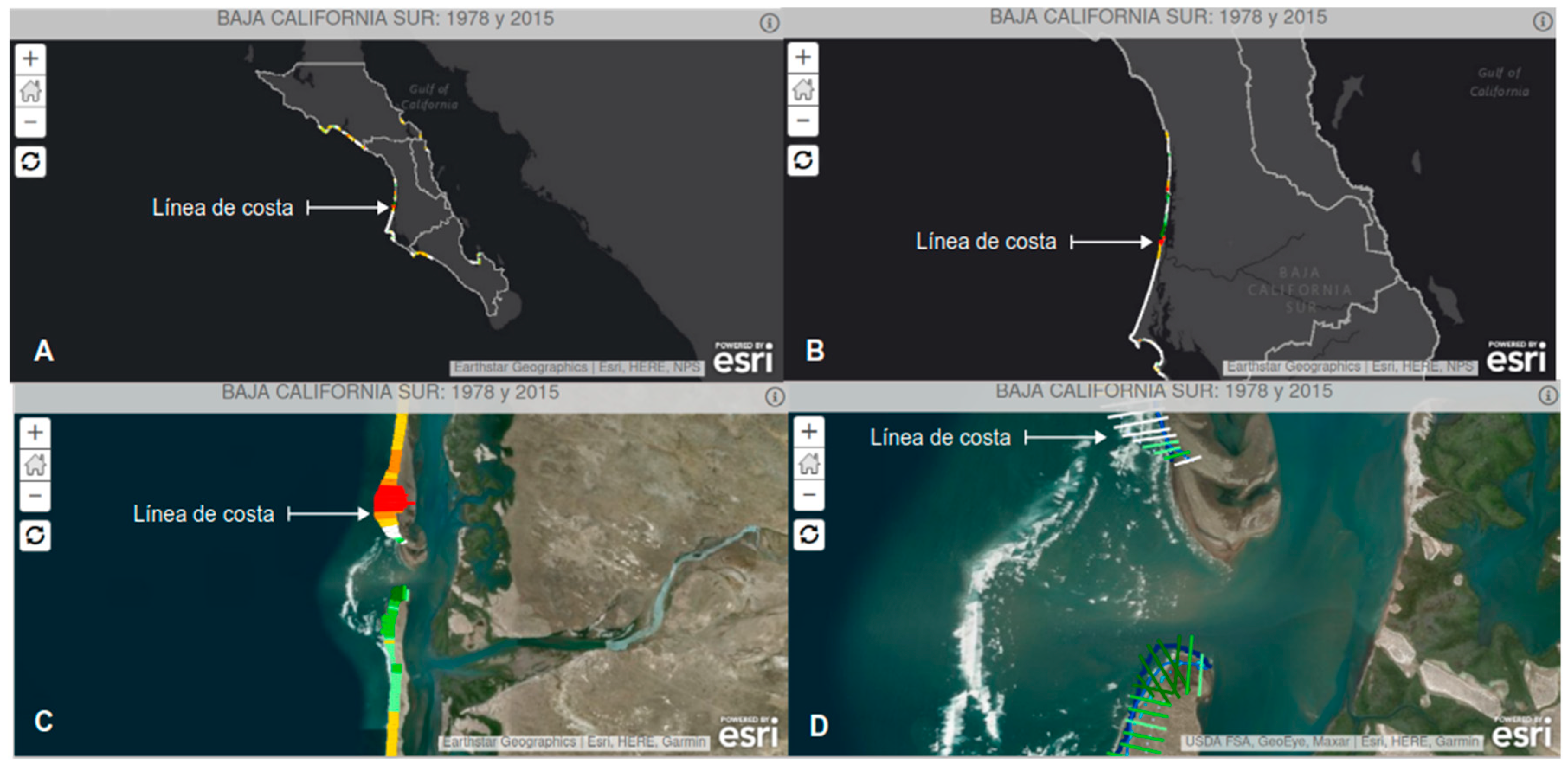
An important challenge in managing coastlines through implementing marine POETs is the inaccuracy of coastline measurements, which are typically constructed at larger scales than 1:250,000; however, effective local administration requires more precise descriptions to accurately identify the specific coast characteristics. As shown in the accompanying figure, the coastline appears as a simple contour when viewed at more minor scales (ranging from 1:250,000 to 1:1,000,000). By increasing the scale to greater than 1:250,000, more detailed features, such as deltas and barrier islands, become visible. At larger scales exceeding 1:10,000, finer details like the federal zone, beaches, and wetlands can be observed.
Figure 3.
Coastline perception at various scales. Data: Own elaboration based on material available on the Atlas of Nature and Society website [43]. “A” and “B”: when observed at small scales (close to 1:1 000 000 the coastline is perceived as a contour. “C and D”: When increasing the scale to more than 1: 250 000 features such as the delta and barrier islands observed in image “C” are perceived, when increasing to scales larger than 1: 10 000 beaches and wetlands can be perceived.
The size of coastal areas significantly impacts the selection of geographic scales used for planning, particularly when defining environmental management units (EMUs). EMUs are the minor territorial units to which specific ecological guidelines and strategies are applied according to the Regulations of the General Law of Ecological Balance and Protection to The Environment in Terms of Ecological Planning. Small or insufficiently detailed scales can obscure important features for setting environmental objectives and ecological criteria and delineating EMUs. Conversely, highly detailed scales may lead to excessive spatial subdivision, making them impractical for management purposes.
Table 6.
Length of the Mexican coastline according to various estimates.
| Source | Estimation method | Lenght |
| Central Intelligence Agency de EEUU (CIA) [41] | Non identified | 9 330 km |
| National Institute of Statistics and Geography (in Spanish Instituto Nacional de Estadística y Geografia (INEGI)) [42] | Topographical charts scale 1:250 000 | 11 122 km |
| National Commision for Biodiversity Knowledge and Use (in Spanish Comisión Nacional para el Conocimiento y Uso de la Biodiversidad de México (CONABIO) [43] | RapidEye satellite imagery, processing level 3A, 5m spatial resolution, scale 1:25,000. * | 15 069 km* |
| Ortiz-Pérez y De la Lanza-Espino (2006) [44] | Topographical charts scale 1:50 000 | 24 945 km |
Note: * Corresponds to the limit of the spectral difference between land-sea, at a specific time between the years 2011-2014 with respect to the date of the satellite image. years 2011-2014 with respect to the date of the satellite image.
3.4.3 Nearshore Dimensions
At the federal level, significant responsibilities and practical challenges are related to sea governance, particularly concerning underwater areas and the land-water interface. The federal government promotes and establishes POETs [1] and oversees the utilization of key marine economic activities, including fisheries, aquaculture, navigation, oil and mineral extraction, and maritime transportation [5].
The aquatic part of Mexico's national territory accounts for 61.59% of its total surface area. This significant percentage presents practical challenges in characterizing and diagnosing a large portion of the country, especially within MCZ. The lack of information, especially about the neritic and oceanic pelagic zones and the submerged topography significantly affects planning efforts. These difficulties stem from the physical inaccessibility of these areas and the considerable technological, financial, and specialized knowledge resources needed for their study. That situation hampers the characterization process required for the formulation of POETs, the delimitation of the UGAs and the application of ecological criteria to guide the technical opinions issued by government officials.
Accessing information about coastal areas in Mexico is takes a long time (often months) because there is no unified system or organization for monitoring, collecting, and disseminating coastal data. This lack of coordination hinders the development and effectiveness of POETs. Furthermore, public entities involved in environmental management—such as the National Institute of Statistics and Geography, the Inter-Secretarial Commission for the Sustainable Management of Seas and Coasts, the Ministry of the Navy, and the Ministry of Environment and Natural Resources—do not have a coordinated public platform for collecting and sharing information specific to coastal regions.
A similar issue is present among research entities and organizations that monitor specific variables, including the National Coast Guard, the National Tide Gauge Service, the National Meteorological Service, the Mangrove Monitoring System, the National Water Commission, and the National Seismological System and Tsunami Alert Center. Their work and information are often widely dispersed and difficult to access, especially in remote coastal areas that lack the necessary means and services, such as internet access. According to the stratification tool provided by the National Institute of Statistics and Geography (INEGI), in coastal states, there are municipalities where only 10.4% of households have internet access.
4. Discussion
Before the formal establishment of the MCZ, analyses and studies of the coastal zone focused mainly on a terrestrial region defined by the boundaries of the 17 coastal states and variable portions of the marine territory within the Mexican Exclusive Economic Zone [see 4, 8, 44, 47]. Therefore, there is still limited literature on the operational role of MCZs in coastal zone management and their interaction with other environmental policies or management instruments.
However, we came across remarkable research [40] which describes the municipalities that later defined the terrestrial portion of the MCZ established. They highlight the importance of considering the territorial classification of the MCZ in future studies, given the need for effective territorial planning and management instruments at both the regional and municipal levels, to ensure that high population concentrations in certain municipalities of the Mexican coastal zone can improve the quality of life of residents while preserving the environmental integrity of these areas.
The operating conditions of the POET are very complex due to the large number of legal elements and operators. Its objective of safeguarding the rights of more than 21 million inhabitants to enjoy a healthy environment and fair access to resources still seems to be a work in progress. Its goal to safeguard the rights of more than 21 million inhabitants to enjoy a healthy environment and fair access to resources is a pending task that depends on the operative contrition's of an always changing and heterogenous socio-ecological system. Municipal administrations have a short three-year term, after which they can renew 100% of their staff, including the technical personnel that operate the agencies responsible for issuing licenses for land use or changes in land use.
Our analysis shows that a POET's effectiveness depends on its design features and the conditions in which it operates. The design features include the instrument's powers and mechanisms, which enable it to regulate land use and guide the location of productive activities initiated by the population or impacting the community. Conversely, operational conditions refer to the scenarios that can enhance or limit these capabilities, ultimately affecting how the POET functions.
POETs exist within a complex physical-natural dimension that is challenging to characterize. The aquatic portion of the national territory makes up 61.59% of its surface area (Figure 1) [50]. This complexity hampers effective diagnosis and management of coastal areas, as it is challenging to manage what is not well understood and when there is not enough material, financial or knowledge resources, to generate or to access reliable information about it.
Access to information challenges is more acute in aquatic regions and insular territories outside the territorial sea, like Guadalupe Island and the Revillagigedo Islands, as well as barrier islands, such as Laguna Madre in the Gulf of Mexico. Data on wetland status is often lacking, as well in the neritic and oceanic pelagic zones. This scarcity results from physical inaccessibility and the substantial resources and expertise required for practical study [16,50] have highlighted these challenges and the difficulties posed by the vastness of coastal areas but none of them are specific about the practical conditions needed. Public entities involved in environmental management, such as the National Institute of Statistics and Geography, the Inter-Secretarial Commission for the Sustainable Management of Seas and Coasts, the Ministry of the Navy, and the Ministry of Environment and Natural Resources, do not have a collective and public platform for gathering and sharing specific information on coastal areas. Similarly, organizations focused on coastal research and monitoring—like the National Coast Guard, the National Tide Gauge Service, the National Meteorological Service, the Mangrove Monitoring System, the National Water Commission, and the National Seismological System and Tsunami Warning Center—have their work and data scattered, making them often difficult to access.
Accessing this information is particularly challenging for coastal communities, many of which lack reliable communication infrastructure, such as internet service because much of the data is only available in digital documents and databases. Moreover, several essential health parameters of coastal ecosystems that are necessary for estimating carrying capacities and establishing ecological criteria within the POET have been overlooked, including shoreline dynamics, surface temperature, acidification and dissolved oxygen levels in marine waters, and atmospheric emissions from urban and industrial coastal areas which is not a new situation [19,20,21,50].
The extent of coastal areas influences the choice of geographic scales for management purposes, particularly in defining environmental management units (UGA). UGAs represent the minor territorial units assigned specific ecological guidelines and strategies [see 52-19-21]. Using small or less detailed scales can obscure important features needed to establish environmental objectives and ecological criteria and delineate the UGA. Contrarily, highly detailed scales can lead to excessive spatial subdivisions, making them impractical for effective management.
The POETs operate under complex and dispersed legal-administrative conditions that hinder their activation mechanisms and, consequently, their functions. A clear signal of intent to use the space and a detection mechanism are required to activate these instruments. The detectors can be any of the more than 300 elements of the public environmental management system mentioned earlier. However, to activate the POET, these detectors must communicate the signal to the rest of the management system, which in turn must activate the organs or elements equipped with the technical capacity, will, and resources to enforce the provisions of the POET.
Controlling individual actions concerning the use and exploitation of coastal space involves influencing and guiding the decisions of a wide array of actors who hold power over land and water portions, whether privately owned or subject to varying concession schemes. The areas in question can range from a few square meters to hundreds of hectares, encompassing features such as ramps, docks, nearby housing developments, aquaculture parks, or ports.
From experience, early signs of land change manifest in various forms and scales. These changes may emerge as development plans for projects proposed by different levels of government or as private initiatives. Often, they present minor alterations just noticed by local inhabitants, frequent users of coastal areas, or proactive authorities who are vigilant about changes. This phenomenon can be described as the "tyranny of small decisions," a concept articulated by Schumpeter [53].
These "small changes" may include actions such as land clearing, road construction, dock building, removal of mangrove vegetation, creation of outlets, construction of protective walls, setting up buildings, sewage discharges, installation of fishing or cultivation equipment, or boat transit, among others. Unfortunately, environmental management systems rarely detect these changes early since they are not formalized through the official mechanisms established by the POETs. Engaging these tools involves procedures that often involve agencies distant from coastal communities and characterized by bureaucratic processes responsible for issuing construction permits, land use change authorizations, fishing and aquaculture concessions, permissions for using genetic resources or stone materials, and especially environmental licenses, to name a few.
Environmental management systems rarely detect coastal changes early because they are not formalized through the activation mechanisms of the POETs. This lack of formalization is due to the lengthy procedures involving agencies far from coastal communities. These agencies are responsible for granting construction licenses, authorizations for changes in land use, fishing-aquaculture concessions, permissions for using genetic resources and stone materials, and, notably, environmental licenses.
The formal activation of POETs tends to occur more frequently for large-scale projects, such as ports, oil platforms, and aquaculture parks, because these investments require the legal certainty that an environmental license provides.
Activation does not guarantee effectiveness, as illustrated by the case of Puerto Costa Azul in Baja California. A report from the Environment and Natural Resources Commission of the LXI Legislature of the Chamber of Deputies highlights deviations from the ecological management guidelines established for the State of health in the UGA North Marine area of North Baja California (NBC 01). This report reveals issues with the functionality of the marine POET in the North Pacific region [54].
The same case illustrates another way POETs can activate through monitoring mechanisms. This process requires operators of the environmental management system to detect and report any signs of changes in the use of coastal space in a formal and timely manner. To accomplish this, it is essential to have technical expertise and a commitment to ensuring personal safety, as complacency and corruption cannot pose significant obstacles. SEMARNAT is responsible for providing training, which entails allocating financial and material resources to educate at least 265 public officials representing the municipalities within the MCZ.
The legal-administrative dimension has allowed us to identify inconsistencies between the characterization and diagnosis of the POETs in relation to the primary objectives of safeguarding the right to a healthy environment and achieving distributive justice. The characterization phase should outline the condition (health) of the environment's natural, social, and economic components [17]. However, it has primarily been formulated in commercial terms, focusing on the supply aspects that describe the structure and suitability of coastal areas for various economic sectors, rather than assessing their health or measuring the capacity and resilience of these environments.
The current diagnoses lack indicators for critical variables that affect environmental and public health. For example, essential factors, including contamination levels, resource availability, sufficiency, and water quality, as well as an inventory of natural resources are considered human wellbeing indicators in a coastal environment [55]. These indicators are crucial for determining whether the UGAs can be classified as a healthy environment and if its resources are distributed equitably.
To assess the coastal area, it is necessary to analyze status indicators such as the availability, quality, and accessibility of water, air, and common goods, including living spaces and the overall coastal environment (see Li, 2021). In Mexico, several proposals incorporate this approach, including those from the National Laboratory of Coastal Resilience that develops report cards focused on coastal management, which are generated from coastal observatories and follow a diagnostic framework to evaluate coastal environmental health based on the methodology focused on the coastal heath [56,57]. This framework is a reference for diagnosing coastal areas and creating effective management models because the objective of constitutional management is not to establish a baseline for the commercial exploitation of territory but to ensure the fundamental right to enjoy a healthy environment.
A mercantile vision prevails in the established marine POETs, as noted by other authors [16]. These POETs were constructed based on a general methodology for formulating ecological ordinances developed by SEMARNAT. This methodology includes characterizing the study area and identifying and describing environmental attributes according to sectoral interests, which is an inventory nor a diagnosis.
In practical terms, these efforts aim to manage the coastal space using tools designed to address social rights; however, their construction often prioritizes mercantile and sectoral objectives.
The social dimension shows the size of a coastal population of at least 25 670 816 inhabitants of the municipalities, who's right to a healthy environment must be safeguarded. However, this dispersed coastal population is larger than that of the Valley of Mexico, which by 2020 had 21,804,515 inhabitants. According to the primary objectives of environmental management, the needs of the coastal population must be satisfied in the first instance through the resources available in the coastal space, starting with the provision of a safe habitat, water security, food security, and sovereignty, and the safeguarding of genetic resources; without this meaning that the coverage of needs for material, energy, information and space for private economic activities must be left aside.
Management models should include the availability of water by environmental management unit and its quality, as well as indicate the criteria for urbanization in aquifer recharge and storage zones, such as wetlands. On the coastline, the ordinances must take into account, for each management unit, traditional uses, establish criteria for the location of access routes to the sea and coastal bodies of water for fishing, aquaculture, and tourist-recreational users, and transients, as well as criteria for the construction of protection works to avoid changes in coastal transport that cause erosion or siltation problems. These criteria may include portfolios of technological options; it is not enough to simply state that risky construction should be avoided, but rather that viable, functional, and desirable technologies, such as living protection works, flexible port designs, etc., should be used.
Land use regulations should include criteria for equitably distributing continental territory and pelagic zones among uses such as transportation, fishing, aquaculture, tourism, mining, water discharge, water intake, and biodiversity itself. This is a major challenge due to the technical difficulty of access and surveillance. The users of these spaces are often not fully identified, as is the case with fishing users known as free fishers. In cases such as oyster fishing, nearly 70% of fishers lack permits (PHD student Isidro O. Montelongo Alfaro, personal communication 13 de Mayo de 2023).
The characterization process should reflect the elements that may be affected by land use policies. It has been observed that the provisions of a land use planning program or other human actions can affect the genetic resources on which fisheries depend or alter the coastal transport on which the formation and maintenance of beaches depend.
Regardless of the coastal zone area to be managed, the maximum limit for its intervention is the territory belonging to the State and its constituent parts according to its Constitution. We support the view of other authors who maintain that territory comprises the human being or the population, the physical space, the legal component or regulatory framework, and the administrative apparatus of government [58]. Characterizing, monitoring, and caring populations in Mexico's coastal areas requires significant material, financial, and personnel investments. This optimization requires allocating resources to the most vulnerable, pressured, and marginalized areas.
The use of policies, guidelines, and strategies assigned to the UGAs should aim to maintain or recover their capacity to produce well-being, environmental services and products, and the integrity and supporting capacities of the organized space.
5. Conclusions
The effectiveness of marine POETs in the Marine Coastal Zone (MCZ) relies on its functional characteristics and operational conditions, particularly at the municipal and federal government levels.
Managing Mexico's coastal regions presents challenges due to administrators limited understanding of physical and natural factors, the complex environmental management systems, and the large, dispersed population that demands access to coastal resources.
POETs should be designed based on the diversity and health of coastal environments and their carrying capacity. They must function as preventive tools for coastal health rather than just allocating resources for economic sectors. Their main goal is to guide land use along more than 265 municipalities across 24,945 square kilometers of coastline, 3,149,920 square kilometers of Exclusive Economic Zone, and 10,570 square kilometers of continental shelf. This involves a public management system with over 500 legal components and nearly 300 operators, ensuring that over 25 million residents have access to a healthy environment and resources.
The greatest operational needs exist at the municipal government level, with the most critical being access to knowledge about coastal areas. Timely access to information regarding coastal zones that are facing pressure for change is essential. Additionally, municipal governments need cognitive abilities and technical skills to provide well-supported technical opinions. This highlights the necessity for developing technical personnel who can maintain a long-term presence within municipal administrative structures, extending beyond the typical three-year term of municipal administrations.
The use of policies, guidelines, and strategies assigned to the UGAs should aim to maintain or recover their capacity to produce well-being, environmental services and products, and the integrity and supporting capacities of the organized space.
Author Contributions
Validation, María Teresa Sánchez-Salazar; Writing – review & editing, Yessil Varinka Saenz-Aguilar.
Funding
This work was made possible thanks to grant 59853 awarded by the National Council of Science and Technology (CONACyT) for doctoral studies within the Postgraduate Program in Geography at the National Autonomous University of Mexico (UNAM).
Acknowledgments
I am grateful for the support of Dr. Gerardo Amador Cano and Master Andrés Latapí Ecalante, for their valuable time and suggestions for the improvement of this paper. I am also grateful to PhD student Isidro Montelongo Alfaro for the information shared.
Conflicts of Interest
The authors declare no conflicts of interest.
Abbreviations
The following abbreviations are used in this manuscript:
| MCZ | Mexican Coastal Zone |
| ETM | Ecological Territory Management |
| LGEEPA | General Law on Ecological Balance and Environmental Protection (acronym in Spanish) |
| POET | Ecological Territory Management Programs (POET, from the Spanish acronym) |
| MCZ | Mexican Coastal Zone |
| UNESCO | United Nations Educational, Scientific and Cultural Organization |
| UGA | Environmental Management Units (acronym in Spanish) |
References
- Ley General del Equilibrio Ecológico y Protección al Ambiente § Capítulo IV § Sección II Diario Oficial de la Federación (DOF) 01-04-2024 [General Law on Ecological Balance and Environmental Protection § Chapter IV § Section II (1988-2024) Official Gazette of the Federation (DOF) 01-04-2024]. Available online: https://www.diputados.gob.mx/LeyesBiblio/pdf/LGEEPA.pdf Acessed 26 January 2025.
- Constitución Política de los Estados Unidos Mexicanos § Artículo 4 [Political Constitution of the United Mexican States § Article 4]. Current text Last reform published Diario Oficial de la Federación 17-01-2025, Mexico City, México. Available online: https://www.diputados.gob.mx/LeyesBiblio/pdf/CPEUM.pdf Acessed 23 January 2025.
- UNESCO-COI/Comisión Europea. Guía internacional de MSPglobal sobre planificación espacial marina/Marítima [MSPglobal International Guide to Marine Spatial Planning/Maritime]V. 2021. París, UNESCO. (Manuales y guías de la COI no 89) Available online: https://www.mspglobal2030.org/wp-content/uploads/2022/04/MSPglobal_InternationalGuideMSP_ES_HighRes.pdf Accessed 26 January 2025.
- California State Governor’s Office of Planning and Research. General Plan Guides State of California. 2017. Available online: https://lci.ca.gov/docs/OPR_COMPLETE_7.31.17.pdf Accessed 26 January de 2025.
- Milanés-Batista C.; Pereira, C. I. y Botero, C. M. Improving a decree law about coastal zone management in a small island developing state: The case of Cuba. Marine Policy. 2019, 101, 93-107. [CrossRef]
- UNESCO-IOC. 2021. MSPglobal Policy Brief: Ocean Governance and Marine Spatial Planning. Paris, UNESCO. (IOC Policy Brief no 5. Available online: https://unesdoc.unesco.org/ark:/48223/pf0000375723 Accessed 28 January de 2025.
- Carmona-Lara, M. del C. Criterios Normativos para el Ordenamiento Ecológico [Regulatory Criteria for Ecological Planning] Boletín Mexicano de Derecho Comparado. 1993, 78, 819-846. [CrossRef]
- Escofet, A. Marco operativo de macro y mesoescala para estudios de planeación de zona costera en el Pacífico Mexicano [Macro and mesoscale operational framework for coastal zone planning studies in the Mexican Pacific]. In. Rivera A, Evelia, Guillermo.J. Villalobos, Isaac Azuz A. y Francisco Rosado M. (Editores). El manejo costero en México. 2004. Universidad Autónoma de Campeche. Available http://etzna.uacam.mx/epomex/pdf/mancos/cap15.pdf Accessed 12 December 2024.
- Instituto Nacional de Ecología (INE) - Secretaría de Medio Ambiente Recursos Naturales (SEMARNAT). Términos de Referencia Etapas de caracterización y diagnóstico del estudio técnico para el Programa de Ordenamiento Ecológico Marino y Regional del Pacífico Norte [Characterization and diagnostic stages of the technical study for the North Pacific Marine and Regional Ecological Management Program]. Instituto Nacional de Ecología Dirección General de Investigación de Ordenamiento Ecológico y Conservación de Ecosistemas Subsecretaría de Planeación y Política Ambiental. Dirección General de Política Ambiental e Integración Regional y Sectorial. SEMARNAT. 2009. Available online: https://www.semarnat.gob.mx/archivosanteriores/temas/ordenamientoecologico/Documents/documentos%20pacifico%20norte/zip/tdr_poemrpn_anexo_oficio_bcs.pdf Accessed 15 December 2019.
- Gómez Orea, D. I. Marco Conceptual de la Ordenación Territorial [Conceptual Framework for Territorial Planning]. In Ordenación territorial. Madrid: Ediciones Mundi-Prensa/ Editorial Agrícola Española. 2001.
- Palacio-Prieto J. L.; Sánchez-Salazar M. T.; Casado-Izquierdo, J. M.: Propin-Frejomil, E.; Delgado-Campos, J.; Velázquez-Montes, A.; Chias-Becerril, L.; Ortiz-Álvarez, M. I.; González-Sánchez, J.; Negrete-Fernández, G.; Gabriel-Morales: Márquez-Huitzil, J.: Nieda-Manzano, R., T.; Jiménez-Rosenberg, R.; Muñoz-López, E.; Ocaña-Nava, D.; Juárez-Aguirre, E.; Anzaldo-Gómez, C.; Hernández-Esquivel, J. C.; Valderrama-Campos, K.; Rodríguez-Carranza, J.; Campos-Campuzano, J. M.; Vera-Llamas-Cruz H. and Camacho Ramírez, C. G. Indicadores para la Caracterización y el Ordenamiento Territorial [Indicators for Characterization and Territorial Planning]. Secretaría de Desarrollo Social, Secretaría de Medio Ambiente y Recursos Naturales Instituto Nacional de Ecología Universidad Nacional Autónoma de México. 2004. Available online: http://www.publicaciones.igg.unam.mx/index.php/ig/catalog/download/161/149/818-1?inline=1 Accessed 28 December 2019.
- H. Cámara de Diputados LX Legislatura Comité del Centro de Estudios de Las Finanzas Públicas Centro de Estudios de Las Finanzas Públicas. Plan Nacional de Desarrollo 2007-20012 Escenarios Programas e Indicadores [National Development Plan 2007-2012 Scenarios, Programs and Indicators.]. México. 2007. Available online: https://cefp.gob.mx/intr/edocumentos/pdf/cefp/cefp0962007.pdf Accessed 28 March 2025.
- Gobierno de La República Plan Nacional de Desarrollo 2013-2018 [National Development Plan 2013-2018]. México, 2013. Available online: https://www.gob.mx/cms/uploads/attachment/file/32349/plan-nacional-de-desarrollo-2013-2018.pdf Accessed 26 March 2025.
- Gobierno de La República Plan Nacional de Desarrollo 2019-2024 [National Development Plan 2019-2024]. México, 2019. Available online: https://framework-gb.cdn.gob.mx/landing/documentos/PND.pdf Accessed 7 March 2025.
- Angeles-Hernández, M., Rovalo-Otero, M. and Tejado-Gallegos, M. Manual de Derecho Ambiental Mexicano [Mexican Environmental Law Manual] Universidad Nacional Autónoma de México Instituto de Investigaciones Jurídicas. México, 2021. Avaliable online: https://salazarvirtual.sistemaeducativosalazar.mx/assets/biblioteca/ab466cb7a086de51e200aa5ead0118e7-MANUAL%20DEL%20DERECHO%20AMBIENTAL%20MEXICANO_.pdf Accessed 12 January 2025.
- Espinoza-Tenorio, A.; Moreno-Báez, M.; Pech, D.; Villalobos-Zapata, G. J.; Vidal-Hernández, L.; Ramos-Miranda, J. Manuel Mendoza-Carranza, José Alberto Zepeda-Domínguez, Graciela Alcalá-Moya, Juan Carlos Pérez-Jiménez, Fernando Rosete, Cuauhtémoc León, Ileana Espejel. El ordenamiento ecológico marino en México: un reto y una invitación al quehacer científico [Marine ecological management in Mexico: a challenge and an invitation to scientific work]. Latin american journal of aquatic research. 2017, 42, 3, 386-400. Available online: doi:10.3856/vol42-issue3-fulltext-1 Accessed 28 March 2025.
- Reglamento de la Ley General del Equilibrio Ecológico y la Protección al Ambiente en Materia de Ordenamiento Ecológico § Capítulo Quinto [Regulations of the General Law on Ecological Balance and Environmental Protection in the Area of Ecological Planning] § Chapter Five]. Official Gazette of the Federation DOF 31-10-2014. Avaliable online: https://www.diputados.gob.mx/LeyesBiblio/regley/Reg_LGEEPA_MEIA_311014.pdf Accessed 15 January 2025.
- Reglamento para el Uso y Aprovechamiento del Mar Territorial, Vías Navegables, Playas, Zona Federal Marítimo Terrestre y Terrenos Ganados al Mar]. Official Gazette of the Federation DOF 21-08-1991. Available online: https://sidof.segob.gob.mx/notas/4739967 Accesed 01 February 2025.
- Acuerdo por el que se expide el Programa de Ordenamiento Ecológico Marino del Golfo de California [Agreement issuing the Marine Ecological Management Program of the Gulf of California]. Official Gazette of the Federation DOF 15-12-2006. Available online: https://dof.gob.mx/nota_detalle.php?codigo=4940652&fecha=15/12/2006#gsc.tab=0 Accesed 28 March 2025.
- Acuerdo por el que se expide la parte marina del Programa de Ordenamiento Ecológico Marino y Regional del Golfo de México y Mar Caribe y se da a conocer la parte regional del propio Programa [Agreement issuing the marine part of the Marine and Regional Ecological Management Program for the Gulf of Mexico and the Caribbean Sea and announcing the regional part of the Program itself]. Diario Oficial de la Federación DOF 24-11-12. Available online: https://www.diputados.gob.mx/LeyesBiblio/dof/2012/nov/DOF_24nov12.pdf Accesed 28 March 2025.
- Acuerdo por el que se da a conocer el Programa de Ordenamiento Ecológico Marino y Regional del Pacífico Norte [Agreement announcing the North Pacific Marine and Regional Ecological Management Program]. Official Gazette of the Federation DOF 09-08-18. Available online: https://www.dof.gob.mx/nota_detalle.php?codigo=5534289&fecha=09/08/2018#gsc.tab=0 Accesed 28 March 2025.
- Acuerdo mediante el cual se expide la Política Nacional de Mares y Costas de México [Agreement by which the National Policy of Seas and Coasts of Mexico is issued.]. Official Gazette of the Federation DOF 30-11-18. Available online: https://dof.gob.mx/nota_detalle.php?codigo=5545511&fecha=30/11/2018#gsc.tab=0 Accesed 28 March 2025.
- Sánchez-Salazar, M.T., Bocco-Verdinelli, G. and Casado-Izquierdo J. M. La política de ordenamiento territorial en México: de la teoría a la práctica. Reflexiones sobre sus avances y retos a futuro [Land use policy in Mexico: from theory to practice. Reflections on progress and future challenges.]. 2013, 19-43. Avaliable online: https://publicaciones.geografia.unam.mx/index.php/ig Accessed March 2025.
- Rivera-Arriaga, E. and Escofet, A. Gobernanza socio-ambiental de las zonas costeras y marinas. Las costas mexicanas, contaminación, impacto ambiental, vulnerabilidad y cambio climático [Socio-environmental governance of coastal and marine areas. Mexican coasts, pollution, environmental impact, vulnerability, and climate change]. UNAM, UAC. 2019, p. 465-492.
- Reguero B. G.; Secaira F.; Toimil A.; Escudero M.; Díaz-Simal P.; Beck M. W; Silva R.; Storlazzi C. and Losada I. J. The Risk Reduction Benefits of the Mesoamerican Reef in Mexico. Front. Earth Sci. 2019, 7, 125. [CrossRef]
- García-Aguirre, M. C. and Graciela Pérez-Villegas. Una Visión Global del Deterioro de los Recursos Bióticos Terrestres en México [Una Visión Global del Deterioro de los Recursos Bióticos Terrestres en México]. Revista Geográfica, 2002, 131: 41–77. Available online: http://www.jstor.org/stable/40992824. Accessed: 13 December 2015.
- Ortiz-Pérez, M. O., and A. M. Linares. Vulnerabilidad al ascenso del nivel del mar y sus implicaciones en las costas bajas del Golfo de México y Mar Caribe. El Manejo Costero en México, Centro EPOMEX Universidad A. De Campeche, Campeche, México 2004, 307-320. Available online http://etzna.uacam.mx/epomex/pdf/mancos/cap20.pdf Accesed 28 March 2025.
- Escudero, M.; Silva R. and Mendoza E. Beach Erosion Driven by Natural and Human Activity at Isla del Carmen Barrier Island, Mexico, Journal of Coastal Research. 2014, 71:62-74. [CrossRef]
- Aragón, M. M. Impactos ambientales generados por el caso Malecón, Cancún (Proyecto Tajamar), Quintana Roo, México. Reflexiones para el desarrollo sustentable del turismo [Environmental impacts generated by the Malecón case, Cancún (Tajamar Project), Quintana Roo, Mexico. Reflections on sustainable tourism development]. Ciencia y Mar. 2017, 21, 62, p 37-55. Avaliable online: https://shorturl.at/V3pJh Accessed 28 March 2025.
- Córdova-Tapia, F.; Zambrano-González, L.; Acosta-Sinencio, S. D.; Levy-Gálvez, K.; Ornelas-García, C. P.; Figueroa-Díaz., M. F. Análisis de la Manifestación de Impacto Ambiental del Proyecto “Cabo Dorado” 03BS2014T0002" [Analysis of the Environmental Impact Statement for the "Cabo Dorado" Project 03BS2014T0002]. 2014. Available online: https://shorturl.at/HsCWf Accessed 28 March 2025.
- Garver, G., and Podhora, A. Transboundary environmental impact assessment as part of the North American Agreement on Environmental Cooperation. Impact Assessment and Project Appraisal. 2008, 26.4, 253-263. Available online: https://doi.org/10.3152/146155108x366013 Accessed 28 March 2025.
- Nava-Fuentes, J. C.; Arenas-Granados, P. and Cardoso-Martins, F. Integrated coastal management in Campeche, Mexico; a review after the Mexican marine and coastal national policy. Ocean & Coastal Management. 2018. 154, 34–45. [CrossRef]
- Gardner, H. (1973) The contribution of operativity to naming capacity in aphasic patients. Neuropsychologia. 11, 213-220. [CrossRef]
- Howard, D., Best, W., Bruce, C., y Gatehouse, C. Operativity and animacy effects in aphasic naming. European journal of disorders of communication. 1995, 30, 3, 286-302. [CrossRef]
- Dul, J. Necessary condition analysis (NCA) logic and methodology of necessary but not sufficient causality. Organizational Research Methods. 2016, 19.1, 10-52. [CrossRef]
- Löfstedt, R. E. The swing of the regulatory pendulum in Europe: from precautionary principle to (regulatory) impact analysis. Journal of Risk and Uncertainty. 2004, 28, p 237-260. Available online: https://link.springer.com/article/10.1023/B:RISK.0000026097.72268.8d Accessed 28 March 2025.
- ¿Qué es la Administración Pública Federal? [What is Federal Public Administration?] March 28, 2025. URL: https://www.gob.mx/gobierno.
- Leyes y Normas del Sector Medio Ambiente [Environmental Sector Laws and Regulations]. March 28, 2025. URL: https://www.gob.mx/semarnat/acciones-y-programas/leyes-y-normas-del-sector-medio-ambiente).
- INEGI. Censo de Población y Vivienda 2020: Datos de municipios [Conjunto de datos][ Census of Population and Housing 2020: Municipalities data [Dataset]]. Instituto Nacional de Estadística y Geografía. 2020. Available Online https://www.inegi.org.mx/programas/ccpv/2020/ Accesed 20 March 2021.
- Azuz-Adeath, I. and Rivera-Arriaga, E. Descripción de la dinámica poblacional en la zona costera mexicana durante el periodo 2000-2005 [Description of the population dynamics in the Mexican coastal zone during the period 2000-2005]. Papeles de población. 2009, 15, 62, 75-107. Available onlie: http://scielo.unam.mx/pdf//pp/v15n62/v15n62a3.pdf Accessed 28 March 2025.
- The World Fact Book Field Listing Coastline. November 21 de noviembre de 2022. https://www.cia.gov/the-world-factbook/field/coastline/.
- INEGI Instituto Nacional de Estadística, Geografía e Informática. Anuario Estadístico de los Estados Unidos Mexicanos 2011 [Statistical Yearbook of the United Mexican States 2011]. Mexico. 2012. Available online: http://internet.contenidos.inegi.org.mx/contenidos/Productos/prod_serv/contenidos/espanol/bvinegi/productos/integracion/pais/aeeum/2011/Aeeum11_1.pdf Accesed 28 March 2025.
- Línea de costa de la República Mexicana (2011 -2014) [Coastline of the Mexican Republic (2011 –2014]. November 21, 2022 http://geoportal.conabio.gob.mx/metadatos/doc/html/lc2018gw.html.
- Ortiz-Pérez. M. A, and de la Lanza-Espino G. Diferenciación del Espacio Costero de México: un Inventario Regional. Serie Textos Universitarios Núm. 3. Available online: https://publicaciones.geografia.unam.mx/index.php/ig/catalog/book/29 Accesed 17 November 2024.
- Ley Orgánica de la Armada de México § Capítulo II § Artículo 2. [Organic Law of the Mexican Navy § Chapter II § Article 2. Official Gazette of the Federation DOF 01-12-2023]. Available online: https://www.diputados.gob.mx/LeyesBiblio/pdf/LOAM.pdf Acessed 28 March 2025.
- Cortina-Segovia, S.; Brachet-Barro, G.; Ibáñez de la Calle, M. and Quiñones-Valadez, L. Océanos y costas. Análisis del marco jurídico e instrumentos de política ambiental. Secretaría de Medio Ambiente y Recursos Naturales (SEMARNAT) México .2007. 233 p. Available oline: https://biblioteca.semarnat.gob.mx/janium/Documentos/Ciga/Libros2013/CD002182.pdf Accesed 28 March 2025.
- Merino, M. The coastal zone of Mexico. Coastal Management. 1987, 15, 1, p 27-42. [CrossRef]
- Padilla y Sotelo, L. S.; Juárez-Gutiérrez, M. del C. and Propín-Frejomil, E.. Población y economía en el territorio costero de México. 2009. Available online: http://coralito.umar.mx:8383/jspui/bitstream/123456789/1384/1/Poblaci%c3%b3n%20y%20econom%c3%ada%20en%20el%20territorio%20costero%20de%20M%c3%a9xico.pdf Accesed 28 March 2025.
- De la Lanza Espino, G. Gran escenario de la zona costera y oceánica de México [Great scenery of Mexico's coastal and oceanic zone]. Ciencias, 2004, 076. Available onlline: file:///home/yvsa/Escritorio/_astrid_sg,+CNS07602.pdf Accesed 28 March 2025.
- Yáñez-Arancibia, A. México 62% Mar. Boletín Informativo Red Ibermar Iberoamericana. 2015, 9, 7-10. Available onlline: https://hum117.uca.es/wp-content/uploads/2019/10/BOLETIN-09-IBERMAR.pdf Accessed 23 December 2016.
- Ohenhen, L. O., Shirzaei, M., Ojha, C., Sherpa, S. F., & Nicholls, R. J. Disappearing cities on US coasts. Nature. (2024), 627, 8002, 108-115. [CrossRef]
- Álvarez-Romero, J. G., Pressey, R. L., Ban, N. C., Torre-Cosío, J., and Aburto-Oropeza, O. (2013). Marine conservation planning in practice: lessons learned from the Gulf of California. Aquatic Conservation: marine and freshwater ecosystems, 23(4), 483-505.
- Kuznets, S. History of Economic Thought-History of Economic Analysis, by Joseph A. Schumpeter. Edited from manuscript by Elizabeth Boody Schumpeter. New York: Oxford University Press, 1954. Pp. xxv, 1260. The Journal of Economic History, 15, 3, 323-325. [CrossRef]
- Comisión Reguladora de Energía (CRE). Evaluación de impacto ambiental del proyecto Energía Costa Azul Investigación y Consultas. Gobierno de México. 2022. Available online: https://www.diputados.gob.mx/documentos/mayo/290411.pdf Accesed. 30 March 20205.
- Sandifer, P. A. Linking coastal environmental and health observations for human wellbeing. Frontiers in Public Health. 2023, 11, p. 1202118. Available online: https://www.frontiersin.org/journals/public-health/articles/10.3389/fpubh.2023.1202118/full Accesed 30 March 20205.
- Costanzo, S.D., Blancard, C., Davidson, S., Dennison, W.C., Escurra, J., Freeman, S., Fries, A., Kelsey, R.H., Krchnak, K., Sherman, J., Thieme, and M. Vargas-Nguyen, V. Practitioner's Guide to Developing River Basin Report Cards. IAN Press. Cambridge MD USA. (2017). Available online: https://shorturl.at/R7Hxk Accesed 30 March 2025.
- Qué son las tarjetas de reporte? [What are transportation cards?]. March 30 2025. URL: https://www.lanresc.mx/publicaciones/tarjetas_reporte/.
- Orozco-Garibay, P. A. El Estado Mexicano. Su estructura constitucional. Jurídicas. Biblioteca Jurídica Virtual del Instituto de Investigaciones Jurídicas de la UNAM. 2004. Available online: http://historico.juridicas.unam.mx/publica/librev/rev/mexder/cont/6/cnt/cnt1.pdf Accesed 22 d November 2020.
Figure 1.
Methodology's flow diagram.
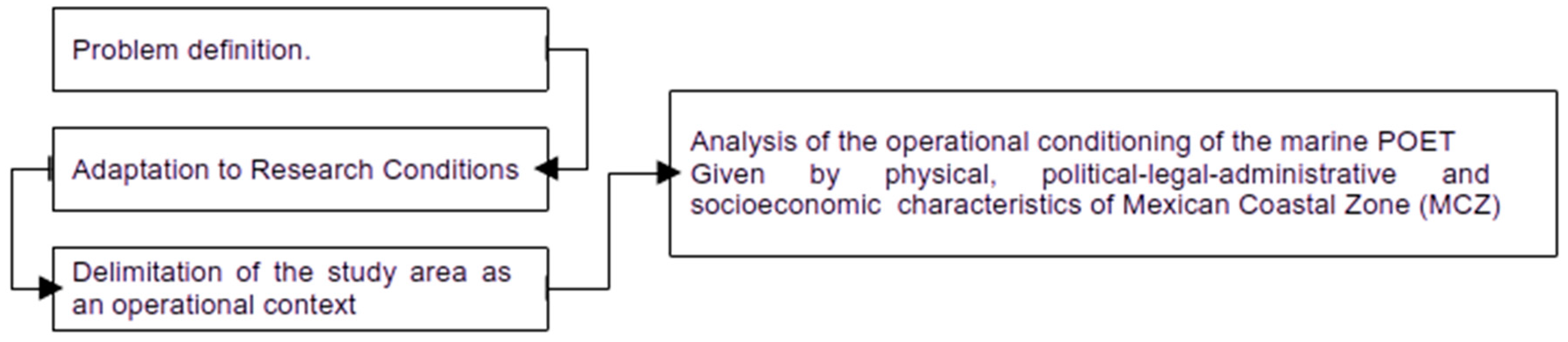
Figure 1.
Study area: Mexican Coastal Zone.
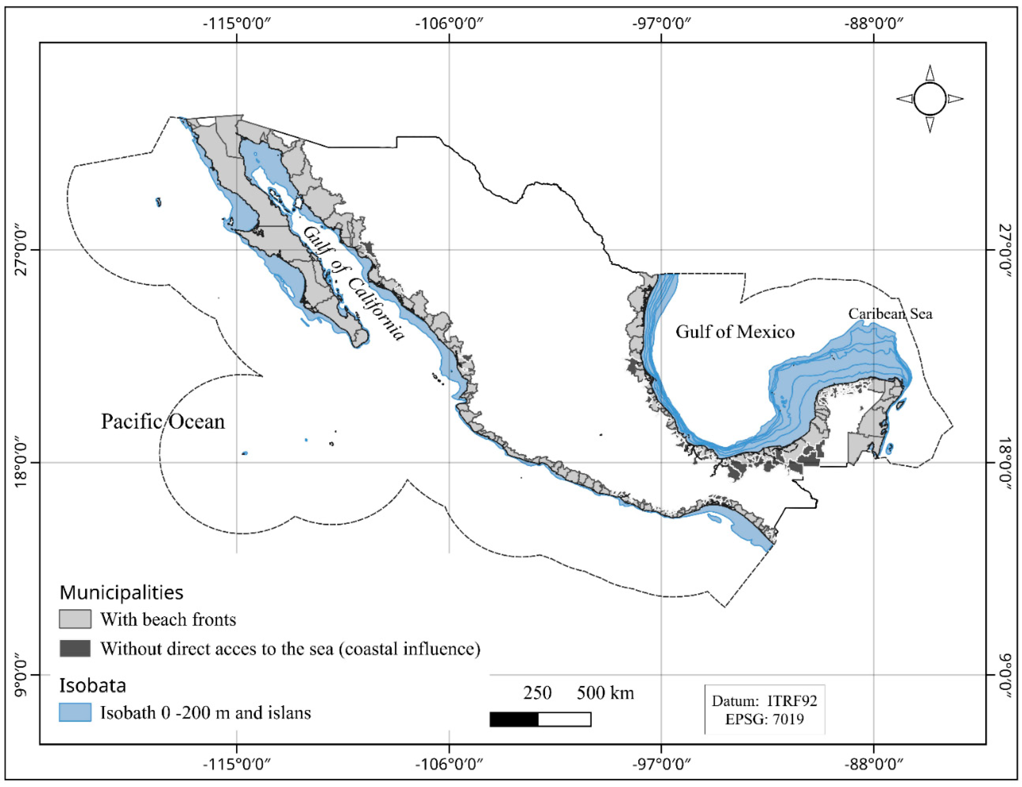
Table 1.
Mexican ecoregions subjected to a marine POET.
| Marine Ecoregions | POET | Year of decree | ||
| Name | Area (km²) | Percentage (%) | ||
| Gulf of California | 262,284 | 8.31 | Gulf of California | 2006 |
| Gulf of México North | 75,298 | 2.39 | Gulf of Mexico and Caribbean Sea Gulf of Mexico and Caribbean Sea |
2012 |
| Gulf of México South | 663,182 | 21.01 | Gulf of Mexico and Caribbean Sea | 2012 |
| Caribbean Sea | 95,534 | 3.03 | Gulf of Mexico and Caribbean Sea | 2012 |
| Central American Pacific | 148,923 | 4.72 | None | None |
| Sud Californian Pacific | 808,154 | 25.61 | North Pacific | 2018 |
| Transitional Pacific of Monterey | 65,225 | 2.07 | North Pacific | 2018 |
| Mexican Transitional Pacific | 1,037,587 | 32.87 | None | None |
| Total | 1,969,677.28 | 62.4 | ||
Data Source: [26]
Table 2.
Essential conditions identified as needed for governmental operators of municipal scope to effectively operating marine POETs within the Mexican Coastal Zone management public system.
Table 2.
Essential conditions identified as needed for governmental operators of municipal scope to effectively operating marine POETs within the Mexican Coastal Zone management public system.
| Municipal Scope |
| CON-1 The territorial scope of application of the POET includes the municipalities of the MCZ. CON-2 The administrative organizational structure of coastal municipalities includes agencies that regulate productive activities in the coastal zone under municipal jurisdiction. CON-3 The operators of the agencies responsible for municipal land use control are aware of the technical, administrative, and legal capacities to apply ecological criteria of the POET and its complementary instruments. The operators of the agencies responsible for municipal land use control have the technical competencies to interpret the ecological guidelines and criteria of the POET. CON-5 The operators of the agencies responsible for municipal land use control have timely access to information on the state of the coastal territory subject to pressure from land use change, which allows them to apply environmental criteria. CON-6 Stakeholders, users, owners, or interested parties of the MCZ space under municipal jurisdiction are aware of the POET and its land use regulatory role. CON-7 Stakeholders, users, owners, or interested parties of the MCZ under municipal jurisdiction have a point of contact with the agencies responsible for land use control that guides them on applying the POET's ecological guidelines and criteria CON-8 The POET has clear and measurable ecological guidelines. They include goals or general statements that reflect the desired environmental status of an environmental management unit. CON-9 The operators of the agencies responsible for municipal land use control have the technical capacity to construct guidelines based on other similar elements, such as environmental policies, ecological criteria, or other components that express in some way the goals or objectives to be achieved in the area subject to pressure from land use change. CON-10 The actors, users, owners, or interested parties of the MCZ space under municipal jurisdiction carry out changes in land use if and only if they have authorization. CON-11 Stakeholders, users, owners, or interested parties in the MCZ under municipal jurisdiction that do not carry out land use changes are sanctioned by the corresponding authorities. CON-12 The land use change control mechanisms of coastal municipalities have mechanisms to compensate for unauthorized changes and the resulting environmental damage. CON-13 There is basic reference information for the operators of the agencies responsible for land use control in coastal municipalities to consult or generate environmental indicators of pressure, status, and response. CON-14 The operators of the agencies responsible for land use control in coastal municipalities are aware of their territorial jurisdiction in terms of land use regulation. CON-15 The operators of the agencies responsible for land use control in coastal municipalities are limited to acting within their territorial scope of jurisdiction in land use regulation. CON-16 When the operators of the agencies responsible for land use control in coastal municipalities detect that a stakeholder does not know to which agency he/she should apply for a land use change, they guide and direct him/her to the corresponding agency. CON-17 The municipal governments, through their agencies, promote urban development based on sustainability criteria through an administrative framework congruent between environmental policy and urban development that induces the creation of territorial reserves and the location of productive and commercial activities with a logic of sustainability. CON-18 The operators of the agencies responsible for the control of municipal land use have both administrative and technical faculties and competencies to carry out inspection and surveillance tasks of land use in the MCZ. CON-19 The knowledge and information about the characteristics, dynamics, and state of the environment in the MCZ is available in such a way that the operators of the agencies responsible for municipal land use control can consult it in an agile and expeditious manner. CON-20 The operators of the agencies responsible for municipal land use control have sufficient material, legal, administrative, and financial resources to carry out land use inspection and surveillance tasks in the MCZ. CON-21 The operators of the agencies responsible for municipal land use control have the working conditions that allow them to perform their duties adequately, effectively, and efficiently. CON-22 The POET has implementation instruments at the municipal level that coordinate its efforts with the state and federal levels. CON-23 The operators of the agencies responsible for land use control in coastal municipalities are aware of the POET implementation instruments that coordinate the efforts of the three levels of government. CON-24 There are instruments for the effective promotion of social participation in the POET implementation process at the municipal level. CON-25 There are effective and efficient instruments for the follow-up of POET implementation actions that are operated by the agencies responsible for land use control at the municipal level. |
Table 3.
Essential conditions identified as needed for governmental operators of state scope to effectively operating marine POETs within the Mexican Coastal Zone management public system.  .
Table 3.
Essential conditions identified as needed for governmental operators of state scope to effectively operating marine POETs within the Mexican Coastal Zone management public system.  .
| State Scope |
| CON-26 The operators of state agencies that promote land use changes in areas of the MCZ are aware of the POET. CON-27 State agency operators promote land use changes in MCZ areas if and only if they are compatible with the POET management model. CON-28 The operators of the state agencies responsible for managing sectorial activities have technical, administrative, and legal capacities to apply the ecological criteria of the POET and its complementary instruments. CON-29 The operators of the state agencies promote the development of the sectorial activities they manage if and only if they are compatible and contribute to the POET management model. CON-30 The operators of the state agencies promote the development of sectorial activities if and only if these, in turn, promote socioeconomic development based on sustainability criteria through a congruent administrative framework between environmental policy and development. CON-31 The operators of the state agencies responsible for managing sectorial activities have administrative and technical powers and competencies to conduct inspections and surveillance of land use in the MCZ CON-32 When the operators of the agencies responsible for the management of sectorial activities detect changes in land use that contravene the POET provisions, they notify the corresponding authorities. CON-33 The POET relies on instruments of execution at the state level to coordinate its efforts with those of the municipal and federal levels. CON-34 The operators of the state agencies that promote the development of sectorial activities are aware of the POET execution instruments that coordinate the efforts of the three levels of government. CON-35 Effective and efficient instruments exist for adequately promoting social participation in the POET execution process at the state level. CON-36 There are effective and efficient instruments for the follow-up of POET implementation actions that are operated by the agencies responsible for land use control at the state level. |
Table 4.
Essential conditions identified as needed for governmental operators of federal scope to effectively operating marine POETs within the Mexican Coastal Zone management public system.
Table 4.
Essential conditions identified as needed for governmental operators of federal scope to effectively operating marine POETs within the Mexican Coastal Zone management public system.
| Federal Scope |
| CON-37 The operators of the federal agencies with powers to authorize the use of marine waters, their elements and natural resources, their adjacent federal zones and the insular territory in areas of the MCZ are aware of the POET. CON-38 The users of marine waters, their elements and natural resources, their adjacent federal zones and the insular territory in areas of the MCZ promote and authorize uses if and only if they are compatible with the management model of the POET. CON-39 The operators of the federal agencies responsible for the management of sectorial activities that affect marine waters, their adjacent federal zones and the insular territory in areas of the MCZ have technical, administrative and legal capacities to apply the ecological criteria of the POET and its complementary instruments. CON-40 The operators of the federal agencies responsible for the management of sectorial activities that affect marine waters, their adjacent federal zones and the insular territory in areas of the MCZ have both administrative and technical faculties and competencies to carry out inspection and surveillance tasks of land use in the MCZ. CON-41 Knowledge and information about the characteristics, dynamics and state of the environment in marine waters, their adjacent federal zones and the insular territory in areas of the MCZ is available in such a way that the operators of the federal agencies responsible for their management can consult it in an agile and expeditious manner. CON-42 The operators of the federal agencies responsible for the management of sectorial activities that affect marine waters, their adjacent federal zones and the insular territory in areas of the MCZ have sufficient material, legal, administrative and financial resources to carry out inspection and surveillance tasks of land use in the MCZ. CON-43 The operators of the federal agencies responsible for the management of sectorial activities that affect marine waters, their adjacent federal zones and the insular territory in areas of the MCZ have the working conditions that allow them to carry out their tasks in an adequate, effective and efficient manner. CON-44 The POET has instruments of execution at federal level that coordinate its efforts with the municipal and state levels. CON-45 The operators of the federal agencies responsible for the management of sectorial activities that affect marine waters, their adjacent federal zones and the insular territory in areas of the MCZ are aware of the POET implementation instruments that coordinate the efforts of the three levels of government. CON-46 There are effective and efficient instruments for the effective promotion of social participation in the POET execution process at the federal level. CON-47 There are effective and efficient instruments for the follow-up of POET implementation actions that are operated by the agencies responsible for land use control at the federal level. |
Disclaimer/Publisher’s Note: The statements, opinions and data contained in all publications are solely those of the individual author(s) and contributor(s) and not of MDPI and/or the editor(s). MDPI and/or the editor(s) disclaim responsibility for any injury to people or property resulting from any ideas, methods, instructions or products referred to in the content. |
© 2025 by the authors. Licensee MDPI, Basel, Switzerland. This article is an open access article distributed under the terms and conditions of the Creative Commons Attribution (CC BY) license (http://creativecommons.org/licenses/by/4.0/).
Copyright: This open access article is published under a Creative Commons CC BY 4.0 license, which permit the free download, distribution, and reuse, provided that the author and preprint are cited in any reuse.


