
Submitted:
22 April 2025
Posted:
22 April 2025
You are already at the latest version
Abstract
Soil processes in rendzinas are primarily influenced by the alkaline earth bedrock, which constitutes the soil substrate. In sloping terrain, these processes are further modified by surface leveling mechanisms, involving the erosion of convex slope sections and the deposition of deluvium in concave areas and at the slope base. These dynamic shapes both the geomorphological profile of the slope and the associated soil development. Four soil profiles were analyzed in the southern Beskyd Foothills near Presov, Slovakia, along a 500-meter east-facing slope with a 67-meter elevation difference. Specific sampling locations included a flat hilltop, a convex slope section, a transition zone from convex to concave slope, and the slope base. Under agricultural cultivation, a deep, skeletal, Calcaric Cambic Leptosol was developed on the flat hilltop. On the 11° inclined convex slope section, a 25-cm thick arable-humus Ap horizon directly overlay solid rock, resulting in a Skeletic Rendzic Leptosol. At the slope base, Endogleic Cambisol was formed from non-skeletal deluvial sediments. Top-down decalcification of detritus, accompanied by the emergence of low hydrolytic acidity, was observed in the slope soils. The sorption complex exhibited a high degree of saturation with alkaline cations, exceeding 93.7%, with calcium being the dominant cation. Notably, sodium levels were relatively constant and reached around 10%. A distinctive characteristic of the soils within this transect was their high total iron content, ranging from 1.82 to 4.50 (9.5)% Fe, contributing to the red coloration (2.5 YR).
Keywords:
geomorphological profile
; soil processes
; iron fractions
; soil color
1. Introduction
Rendzinas are interzonal soils found across a broad latitudinal range, from boreal to subtropical regions, developing on various parent materials ranging from Jurassic to Tertiary and Pleistocene formations [1,2,3,4]. They are characterized by the presence of limestone skeletal fragments throughout the profile, a neutral to alkaline soil solution pH, and a high calcium carbonate content [5,6,7,8,9]. These soils are typically shallow, rich in organic matter, develop on soft parent materials, and consistently contain carbonates, with concentrations increasing with depth, often exhibiting a 2.5 YR or yellower hue [10,11,12].
Studies on the agricultural use of rendzinas have examined their performance in both flat terrains [13,14] and specific topographic features [4]. According to Sokouti and Razagi [15], Weihrauch and Opp [16], Goldie [17], Peng et al. [18], and Calvo-Cases et al. [19], the analyzing rendzina functionality on slopes requires considering the soil cover structure along specific transects. This is connected with the spatial variability of soil physical properties influenced by varying erosion rates across karst landscapes. In the Mediterranean region, soils derived from limestone, including Terra Rossa (Ferralic Cambisols) and rendzinas (Rendzic), are common and frequently studied [3,20,21,22,23,24]. Singer et al. [25], in their long-term monitoring study of soil moisture and temperature distribution, found that humidity is from 5 to 10% higher in rendzina profiles and temperature 5 °C lower, on average, as compared to Terra Rossa soil under the same environmental conditions, and their red color is not a distinguishing feature. In the Carpathians, where limestone-derived soils (Tertiary) are less prevalent, rendzinas are the dominant type, occasionally displaying rubefaction [26]. The environment of the Western Carpathians and adjacent foothills has been significantly altered by human economic activities. Deforestation and agricultural land use have intensified weathering, erosion, and denudation processes, impacting soil processes [27,28] and compromising sustainable agriculture. Furthermore, intensive decalcification in cultivated rendzinas contributes to substantial CO2 emissions.
The primary objective of this study was to determine the influence of soil location within a sculpted landscape on the structure and selected properties of agriculturally managed rendzina soils.
2. Materials and Methods
The study was conducted in Demjata, near Presov, Slovakia, within the Beskid Foothills (Zahradniarska Brazda micro-region), at the junction of the flysch Western and Eastern Carpathians (Figure 1).
The geological substrate consists of Mesozoic spotted marls and marls interbedded with calcareous sandstones of the Puchov Formation (Cognac-Maastricht). These rock complexes feature alternating layers of gray spotted marls and loamy limestone, ranging from 5 to 20 cm in thickness, along with insertions of colored calcareous siltstones and sandstones. The formation's total thickness reaches 100-150 meters. The spotted marls and marls exhibit brick-red, purple-gray, and magenta-green hues, and display tabular or flintlock fracturing. During the Alpine orogeny, the rock complex underwent two phases of folding and subsidence: the Laramide (Cretaceous-Paleocene) and Pyrenean (Eocene-Oligocene), resulting in discontinuities in the nappe structure (tectonic mélange) and the formation of calcite veins [29]. The contemporary relief of Zahradniarska Brazda is characterized by hill-type terrain with gently sloping inclines (15-20°) and broad, dome-shaped ridges, punctuated by isolated hills with limestone outcrops (some exploited) and abundant Jurassic and Cretaceous microfossils [30,31].
The climate is classified as slightly wet mountainous, transitioning between warm and slightly warm zones with cold winters. The average January temperature is -3.9 °C, July 17.6 °C, and the annual mean is 8.6 °C, with an annual precipitation of 620 mm, 68% (420 mm) of which falls during the growing season. Annual insolation totals 1956 hours, with 72% (1417 hours) occurring during the vegetation period. Prevailing winds are from the north and northwest, with an average speed of 5.5 m s-1 [32]. The limestone bedrock favors the development of xerothermic ecosystems. The northern distribution limit of the Pannonian plant species Echium rubrum, a protected species, traverses the area.
Within an east-facing convex-concave slope sequence, subjected to intensive agricultural cultivation (alfalfa above 350 m a.s.l., corn below), four soil profiles (Table 1, Figure 2) were excavated post-harvest (September).
Profile P-1 was located on a flat hilltop (392 m a.s.l.), exhibiting no signs of surface erosion and featuring rounded limestone fragments on the surface. Profiles P-2 (347 m a.s.l.) and P-3 (336 m a.s.l.) were situated mid-slope, 310 and 360 meters respectively from P-1, and displayed numerous sharp-edged limestone fragments with recent fracture signs. Profile P-2, located on the steepest incline, exhibited linear runoff rills and a network of cracks on the dry surface, including larger, continuous cracks (up to 8 mm wide and 35 cm deep) and a dense network of smaller, perpendicular cracks. Profile P-4, located at the slope base (325 m a.s.l.), within a depositional zone with good drainage, exhibited a dry, hard surface layer (3-5 mm thick) with polygonal cracks and upturned edges, indicating volume changes due to dehydration.
Soil samples with disturbed structure were analyzed for bulk density (pycnometry), particle size distribution (Cassagrande sedimentation and sieve method for 1-2 mm fraction), dry soil color (Munsell chart), CaCO3 content (Scheibler volumetric method), pH (water and 1M KCl, potentiometry), C and N content (mass spectrometry), exchangeable Ca, Mg, K, and Na (1M NH4Cl extraction, Hitachi 2000 spectrophotometry), and hydrolytic acidity (Kappen method). Total iron and its fractions were determined using sequential extraction by Tessier et al. [33] (Table 2).
Soil samples with intact structure were analyzed for current humidity, hygroscopic water content, and bulk density, allowing for total porosity calculation. Surface runoff was estimated using the USLE equation [34].
3. Results
The variability of limestone soils within the transect reflected the local intensity of morphogenetic processes that shaped the slope's geomorphological profile. The convex-concave slope morphology resulted from resistant upper layers and readily erodible lower layers, exhibiting a slight monoclinal collapse. Genetic horizons were poorly developed, and soil physical properties varied both within and between profiles (Table 3). The soil on the flat hilltop (P-1) was skeletal (30-50% skeleton) and deep. The thinnest skeletal mantle rock (48 cm) was observed on the upper convex slope (P-2), indicating formation on resistant bedrock and significant erosion. The concave slope base (P-3), formed from less resistant rocks, exhibited a thick profile with lower skeleton content (10-30%). Deluvial material accumulation at the slope base resulted in a deep, non-skeletal soil (P-4). Soils were primarily dusty clays, with shallow soils on the slope (P-2) revealing clear stratification of slightly weathered, varicolored, fine-bedded claystones interlayered with hard, non-disintegrating limestone just below the arable-humus layer.
Calcium carbonate content was high, ranging from 23.6% to 56.5%, except in the Ap horizon of P-1 (4.20%) and within the solum of P-4 (1.00-3.80%). In profiles 1, 2, and 3, CaCO3 content was lower in surface horizons and increased with depth, suggesting top-down progressive decalcification.
Organic carbon (Corg) content in Ap horizons ranged from 1.11% (slope base) to 1.41% (hilltop), decreasing in lower horizons. Corg extended to 48-55 cm in slope and hilltop soils and to 80-105 cm in the BC2 horizon of the deluvial soil (0.55%). Surface horizons exhibited moderately developed, medium-durable tubercular structures, while deeper horizons had predominantly platonic-solid, medium-durable structures. The C/N ratio was narrow (6.55-7.39) in slope and base soils, showing no clear pattern. In the hilltop soil, the C/N ratio was 8.01 in the Ap horizon, decreasing to 6.67 at depth, indicating variations in biological activity.
Soils were alkaline, with slightly lower pH in surface horizons (Table 4), and exhibited minor top-down acidification, indicated by hydrolytic acidity of 0.15-0.45 cmol(+) kg-1 in the upper profile.
The sum of exchangeable bases was higher in surface horizons of slope soils (above 10 cmol(+) kg-1) compared to the base (below 9 cmol(+) kg-1), correlating with humus content. In hilltop and base profiles, depth showed no clear relationship. Exchangeable cations saturated 100% of the sorption complex in lower horizons and 95-98% in surface horizons. Calcium dominated (>75% in Ap, increasing with depth; Figure 3). Sodium levels were relatively constant and high, likely of anthropogenic origin (liquid manure).
Field-measured soil moisture showed dry conditions in hilltop and slope soils, with slightly higher moisture at depth (16.4% and 13.5%) compared to surface (13.2% and 11.4%). The base soil was moister, with hydromorphic features below 80 cm and saturation below 105 cm (inner-sheet runoff). Total porosity varied more within profiles than between them (Table 5), being 6.7-10.4% higher in Ap horizons.
Total iron content ranged from 1.82% to 4.50%, with 9.5% in weathered red clays of profile 2's C horizon (Table 6).
Total iron tended to be higher in lower horizons of hilltop and slope soils, but decreased with depth in the base soil. Ion-exchangeable iron (FeI) showed no clear pattern (0.05-0.08 mg kg-1). Carbonate-bound iron (FeII) was lower in slope soils and higher in the base soil (0.31-1.30 mg kg-1) and hilltop soil (1.24-2.93 mg kg-1). Easily reducible iron (FeIII) varied within and between profiles, generally decreasing with depth. The base soil had the highest FeIII share (8.68% in BC). Sulfide and organic-bound iron (FeIV) correlated with Corg content, being highest in the base soil's Ap horizon (0.42 g kg-1).
USLE-estimated annual surface runoff was 230 kg ha-1 on the hilltop, 95 Mkg ha-1 in the concave slope between profiles 2 and 3, and 25 Mkg ha-1 in the concave slope between profiles 3 and 4, reflecting slope morphology and vegetation cover.
4. Discussion
Slope morphology significantly influences soil cover structure [35,36]. The marked differentiation of soil processes, morphology, and rendzina properties observed across the 500-meter slope transect (approximately 70-meter elevation difference) primarily reflects terrain morphology, bedrock characteristics, and land use practices. In contrast to high mountain environments where climatic zonation drives soil processes, climate plays a relatively minor role in this setting [37,38].
On the plateau, where erosion and denudation are minimal, in situ weathering of limestone results in a gradual increase in soil solum thickness, leading to the formation of Calcaric Cambic Leptosols. Conversely, Skeletic Rendzic Leptosols develop on the convex slope section (between profiles P-2 and P-3) due to substantial mantle rock runoff and profile rejuvenation (shortening). Van Loo et al. [39] identify deforestation as a major driver of slope erosion in the Taurus Mountains. Similarly, Zasoński [4] suggests that cultivated rendzinas in the Carpathians are secondary formations, with profile shallowing and exposure of carbonate-rich horizons resulting from intense erosion associated with land use changes. Carpathian soil runoff rates are substantial, averaging 0.2 kg/ha/year in forested areas, 51 kg/ha/year in grasslands, and ranging from 108 kg/ha/year for cereals to 74,000 kg/ha/year for root crops, corresponding to a 2.79 mm layer loss [40]. Surface runoff on agricultural land is strongly influenced by slope inclination, with a threefold increase in runoff on dusty soils at a 16° slope compared to a 7° slope [41]. Furthermore, runoff in flysch bedrock areas correlates more with surface runoff volume than rainfall amount, reaching 11-12% of rainfall in root crop fields on clay and clay-pebble soils, approximately 50% higher than in cereal and grassland fields [42]. Studies have shown that at a 11-12° slope, losses amount to 25,600 kg/ha/year for potato crops, 1,200 kg/ha/year for cereals, and 87 kg/ha/year for meadows, highlighting the significant role of land use in runoff generation. Model studies further confirm the influence of vegetation on precipitation distribution, runoff, infiltration, and erosion [43].
In the present study, the convex slope section (between P-1 and P-2), with an average 11° inclination, exhibited an estimated erosion rate of 95,000 kg/ha/year. In contrast, the concave section (between P-3 and P-4), with an average 3° inclination, showed only 25,000 kg/ha/year, indicating approximately 70,000 kg/ha/year of deluvial accumulation. These deposits, representing an annual layer thickness of about 2.47 mm, contribute to soil profile development at the slope base, influencing both geomorphological and soil processes. This accumulation leads to the formation of a surface soil that exhibits characteristics of a mollisol, but also endogleyic cambisol. These soils typically display poor structure and low porosity [44].
The reddish hue (2.5 YR) observed across the slope profiles is attributed to relatively high iron and humus content. Increased surface erosion and soil profile rejuvenation on the slope result in lighter soil colors (5-6 value) compared to hilltop and base soils (3-4 value). The higher color purity (chroma 6-7) in the convex slope section is associated with lower moisture content and the presence of hematite [26,45], as well as lower organic matter content.
5. Conclusions
- -
- On cultivated slopes, rendzina solum thickness is inversely related to inclination. On 11° convex slopes, a 25 cm Ap horizon directly overlies bedrock, while on flat hilltops, soil processes extend to 48 cm.
- -
- Non-skeletal deluvium (profile P-4) to 1 m depth contains 1.0-3.8% CaCO3 and 0.55-1.11 % Corg, exhibiting redoxymorphic processes at depth.
- -
- Cultivated rendzinas on slopes show slight surface acidification, with sodium comprising approximately 10% of the sorption complex, irrespective of terrain location.
- -
- These rendzinas are characterized by high total iron content (up to 4.5%, locally 9.5% Fe) and a reddish hue (2.5 YR), with soil humus reducing brightness (value) and iron oxide reduction lowering color purity (chroma).
Author Contributions
Conceptualization, M.P. and J.V.; methodology, J.V.; software, M.P.; validation, S.T. and J.G.; formal analysis, J.V.; investigation, S.T.; resources, M.P.; data curation, J.G.; writing—original draft preparation, J.V.; writing—review and editing, S.T.; visualization, M.P.; supervision, S.T.; project administration, J.V.; funding acquisition, J.G. All authors have read and agreed to the published version of the manuscript.
Funding
This research received no external funding.
Data Availability Statement
The data that support the findings of this study are available from the corresponding author, J.V., upon reasonable request.
Acknowledgments
This work was supported by the Scientific Grant Agency of Ministry of Education of Slovak Republic under Grant No. VEGA 1/0100/22.
Conflicts of Interest
The authors declare no conflicts of interest.
References
- Abakumov, E. Rendzinas of the Russian Northwest: Diversity, Genesis, and cosystem Functions: A Review. Geosciences 2023, 13(7), 216. [CrossRef]
- Smoliková, L.; Ložek, V. Zur Altersfrage der miteleuropȁischen Terrae calcis. Eiszeitalter und Gegenwart 1962, 13, 155-177.
- Velde, B. Surface cracking and aggregate formation observed in a rendzina soil, La Touche (Vienne) France. Geoderma 2001, 99 (3-4), 261-276.
- Zasoński, S. Gleby wapniowcowe wytworzone z wybranych ogniw litostratygraficznych fliszu Wschodnich Karpat. Cz I. Ogólna charakterystyka gleb. Roczniki Gleboznawcze 1993, 44 (3-4), 121-133.
- Kabala, C. Rendzina (redzina) – Soil of the Year 2018 in Poland. Introduction to origin, classification and land use of rendzinas. Soil science annual 2018, 69 (2), 63-74.
- Bielek, P.; Šurina, B. Malý atlas pôd Slovenska. VÚPOP: Bratislava, Slovakia, 2000; p. 36.
- Dobrzański, B.; Konecka-Betley, K.; Kuźnicki, F.; Turski, R. Rędziny Polski. Roczn. Nauk Roln., ser. D, Poland, 1987; p. 143.
- FAO/UNESCO. Soil Map of the World. Revised legend with corrections and updates. ISRIC Press. Wageningen, The Netherlands. 1997.
- Sladkova, J. An Analysis of the Rendzina Issue in the Valid Czech Soil Classification System. Soil and Water Research 2009, 4 (2), 66-82. [CrossRef]
- Torrent, J.; Schwertmann, U.; Fechter, H.; Alferez F. Quantitative relationships between soil color and hematite content. Soil Science 1983, 136 (6), 354-358. [CrossRef]
- Torrent, J.; Cabedo, A. Sources of iron oxides in reddish brown soil profiles from calcarenties in southern Spain. Geoderma 1986, 37 (1), 57-66. [CrossRef]
- Sandler, A.; Taitel-Goldman, N.; Ezersky, V. Sources and formation of iron minerals in eastern Mediterranean coastal sandy soils – A HRTEM and clay mineral study. Catena 2023, 220(7), 106644. [CrossRef]
- Leviel, B.; Gabrielle, B.; Justes, E.; Mary, B.; Gosse, G. Water and nitrate budgets in a rendzina cropped with oilseed rape receiving varying amounts of fertilizer. European Journal of Soil Science 1998, 49 (1), 37-51.
- Wójcikowska-Kapusta, A.; Niemczuk, B. Wpływ sposobu użytkowania na zawartość różnych form magnezu i potem w profilach rędzin. Acta Agrophysica 2006, 8 (3), 765-771.
- Sokouti, R.; Razagi, S. Erodibility and loss of marly drived soils. Eurasian Journal of Soil Science 2015, 4 (4), 279-286. [CrossRef]
- Weihrauch, Ch.; Opp, Ch. Soil phosphorus dynamics along a loess-limestone transect in Mihla, Thuringia (Germany). Journal of Plant Nutrition & Soil Science 2017, 180 (6), 768-778.
- Goldie, H.S. Erratic judgements: re-evaluating solutional erosion rates of limestones using erratic-pedestal sites, including Norber, Yorkshire. Area 2005, 37 (4), 433-442.
- Peng, X.; Dai, Q.; Li, Ch.; Yuan, Y.; Zhao, L. Effect of simulated rainfall intensities and underground pore fissure degrees on soil nutrient loss from slope farmlands in Karst Region. Transactions of the Chinese Society of Agricultural Engineering 2017, 33 (2), 131-140.
- Calvo-Cases, A.; Boix-Fayos, C.; Imeson, A.C. Runoff generation, sediment movement and soil water behaviour on calcareous (limestone) slopes of some Mediterranean environments in southeast Spain. Geomorphology 2003, 50 (1-3), 269-292.
- Bellanca, A.; Hauser, S.; Neri, R.; Palumbo, B. Mineralogy and geochemistry of Terra Rossa soils, western Sicily: insights into heavy metal fractionation and mobility. The Science of the Total Environment 1996; 193 (1), 57-67.
- Durn, G.; Ottner, F.; Slovenec, D. Mineralogical and geochemical indicators of the polygenetic nature of terra rossa in Istria, Croatia. Geoderma 1999, 91 (1-2), 125-150.
- Sanchez-Maraũón, M.; Soriano, M.; Delgado, G.; Delgado, R. Soil Quality in Mediterranean Mountain Environments: Effects of Land Use Change. Soil Science Society of America Journal 2002, 66 (3), 948-958.
- Strunk, H. Soil degradation and overland flow as causes of gully erosion on mountain pastures and in forests. Catena 2003, 50 (2-4), 185-199.
- Yaalon, D.H. Soils in the Mediterranean region: what makes them different? Catena 1997, 28 (3-4), 157-169.
- Singer, A.; Schwertmann, U.; Friedl, J. Iron oxide mineralogy of Terra Rosse and Rendzinas in relation to their moisture and temperature regimes. European Journal of Soil Science 1998, 49(3), 385-395. [CrossRef]
- Bronger, A.; Ensling, J.; Gűtlich, P.; Spiering, H. Rubification of Terrae Rossae in Slovakia: a Mossbauer effect study. Clays and Clay Miner 1983, 31 (4), 269-276.
- Kalicka, M.; Witkowska-Walczak, B.; Sławińska, C.; Dębicki, R. Impact of land use on water properties of rendzina. International Agrophysics 2008, 22 (4), 333-338.
- Voiculescu, M. The present-day erosional processes in the alpine level of the bucegi mountains - southern carpathians. Forum Geografic. 2009, 8 (8), 23-37.
- Maheľ, M. Geologicka stavba československých Karpat. Paleoalpinske jednotky. Veda SAV, Bratislava, Slovakia, 1986; p. 479.
- Harčár, J.; Kondračova, V.; Maltovič, R.; Michaeli, E. Prešov, Prešovský okres a Prešovský kraj. Geografickie exkurzie. University of Presov, Slovakia, 1998; p. 196.
- Nemčok, J. Vysvetlivky ku geologickej mape Pienin, Čergova, Ľubovnianskej a Ondavskej vrchoviny. GUDŠ, Bratislava, Slovakia, 1990; p. 35-44.
- Michaeli, E. Regionalna geografia Slovenskiej Republiky. University of Presov, Slovakia, 2008; p. 240.
- Tessier, A.; Campbell, P.G.; Bisson, M. Sequential extraction procedure for the speciation of particulate trace metals. Analytical Chemistry 1979, 51 (7), 844-851.
- Wischmeier, W.H.; Smith, D.D. Predicting rainfall erosion losses – a guide to conservation planning. U.S. Dep of Agriculture, Agriculture Handbook No. 537. 1978.
- Gąsior, J.; Jakobińczuk, W.F.; Oliwa, B. Kształtowanie się właściwości gleb górskich Karpat pod trwałymi użytkami zielonymi. Zeszyty Naukowe AR Kraków 2003, 399(89), 71-79.
- Kowalkowski, A;, Borzyszkowski, J. Badania nad związkami między morfologią powierzchni ziemi a strukturą pokrywy glebowej. Roczniki Gleboznawcze 1997, 28 (3/4), 3-17.
- Birkeland, P.W.; Shroba, R.R.; Burns, S.F.; Price, A.B.; Tonkin, P.J. Integrating soils and geomorphology in mountains – an example from the Front Range of Colorado. Geomorphology 2003, 55 (1-4), 329-344.
- Partyka, A.; Gąsior, J.Struktura pokrywy glebowej na południowych stokach w najwyższej części Bieszczadów Zachodnich w miejscowości Brzegi Górne. Zeszyty Problemowe Postępów Nauk Rolniczych 2003, 493, 455-463.
- Van Loo, M..; Dusar, B.; Verstraeten, G.; Renssen, H.; Notebaert, B.; D'Haen, K.; Bakker, J. Human induced soil erosion and the implications on crop yield in a small mountainous Mediterranean catchment (SW-Turkey). Catena 2017, 149 (1), 491-504.
- Starkel, L.; Baungart-Kotarba, M.; Michna, E.; Gil, E.; Pohl, J.; Słupik, J.; Zawora, T. Studia nad typologią i oceną środowiska geograficznego Karpat i Kotliny Sandomierskiej. Prace Geograficzne IG PAN 1978, 125, p. 165.
- Klima, K.; Wiśniowska-Kielian, B. Ocena strat gleby w wyniku spływu powierzchniowego w rejonie wyżynnym zależnie od rodzaju użytku. Zeszyty Problemowe Postępów Nauk Rolniczych 2007, 520, 821-827.
- Bochenek, W.; Gil, E. Water circulation, soil erosion and chemical denudation in flysh catchment area. Przegląd Naukowy, Inżynieria i Kształtowanie Środowiska 2007, 2 (36), 28-42.
- Cerda, A. Parent material and vegetation affect soil erosion in eastern Spain. Soil Science Society of America journal 1999, 63 (2), 362-368. [CrossRef]
- Badía, D.; Orús, D.; Doz, J. R.; Casanova, J.; Poch, R.M.; García-González, M.T. Vertic features in a soil catena developed on Eocene marls in the Inner Depression of the Central Spanish Pyrenees. Catena 2015, 129, 86-94. [CrossRef]
- Mirabella, A.; Carnicelli, S. Iron oxide mineralogy in red and brown soils developed on calcareous rocks in central Italy. Geoderma 1992, 55 (1-2), 95-109.
Figure 1.
Localization and course of the transect.
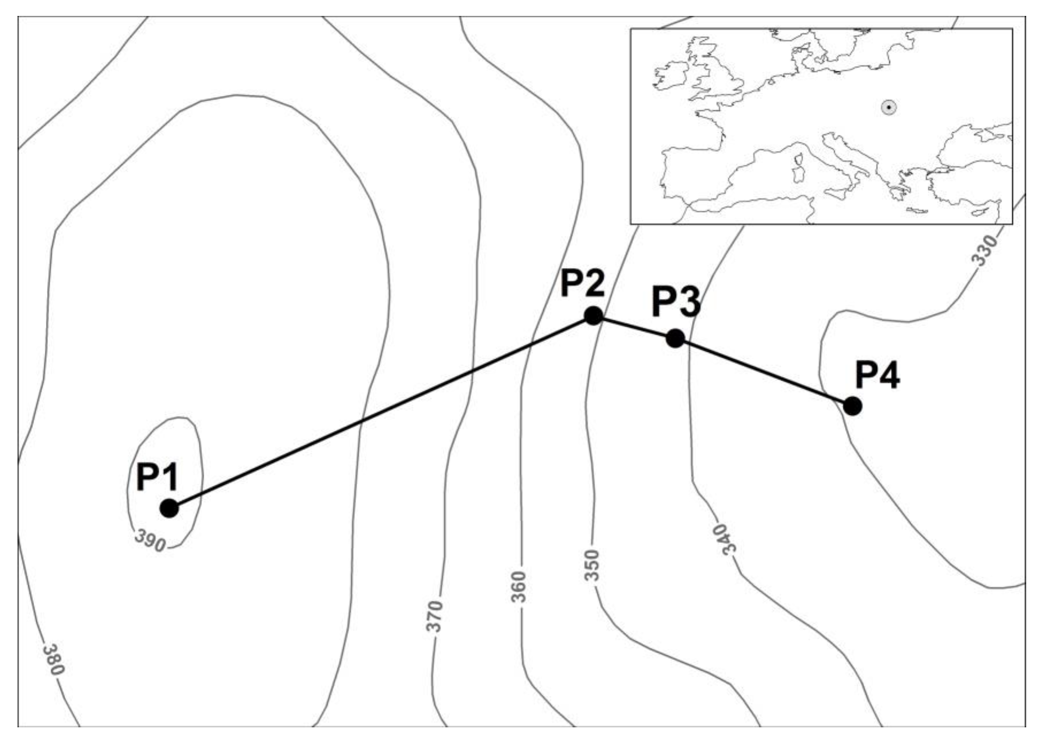
Figure 2.
Geomorphological profile of the slope.
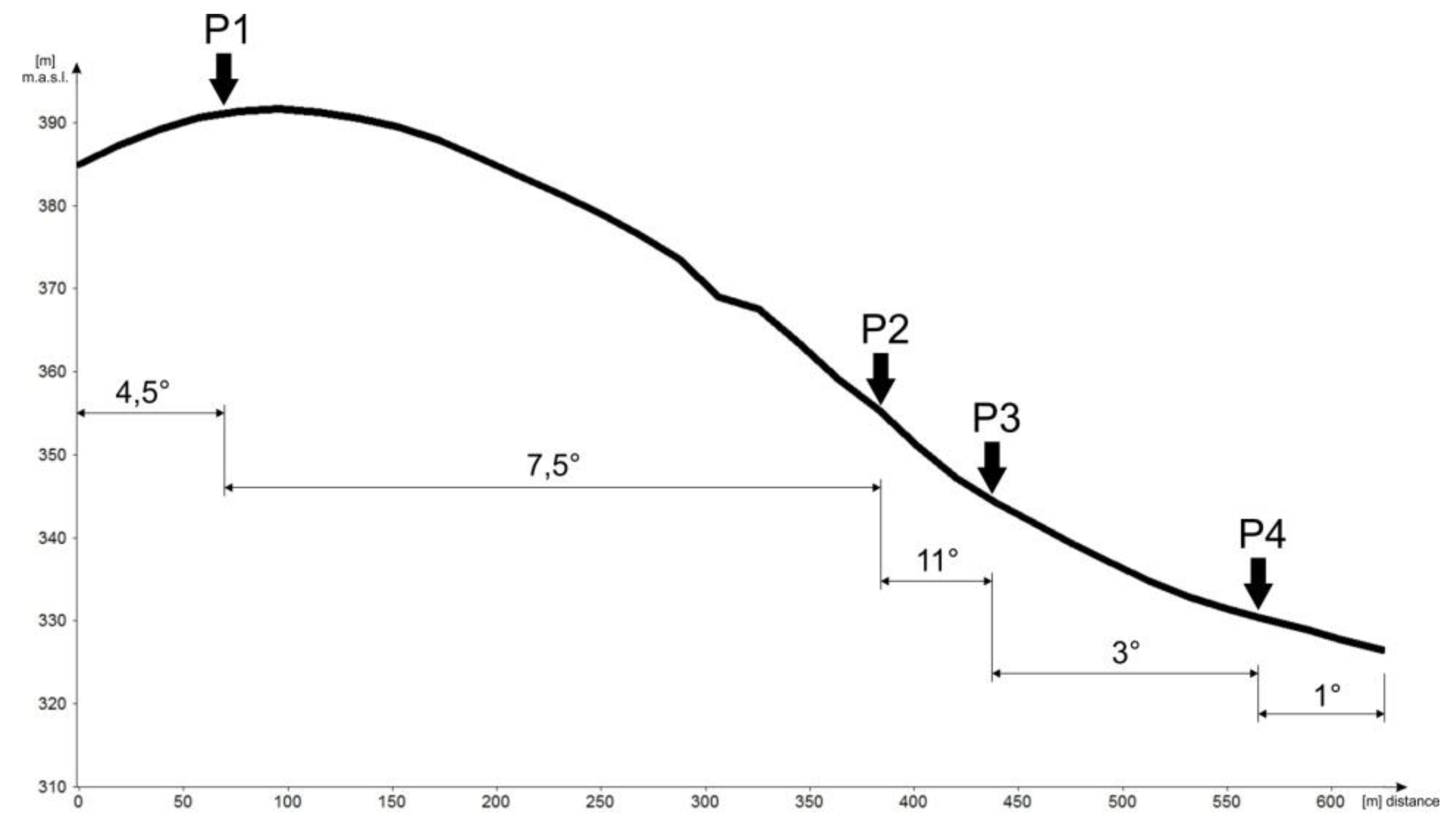
Figure 3.
Proportion of cations Ca, Na, Mg, and K in sorption complex.
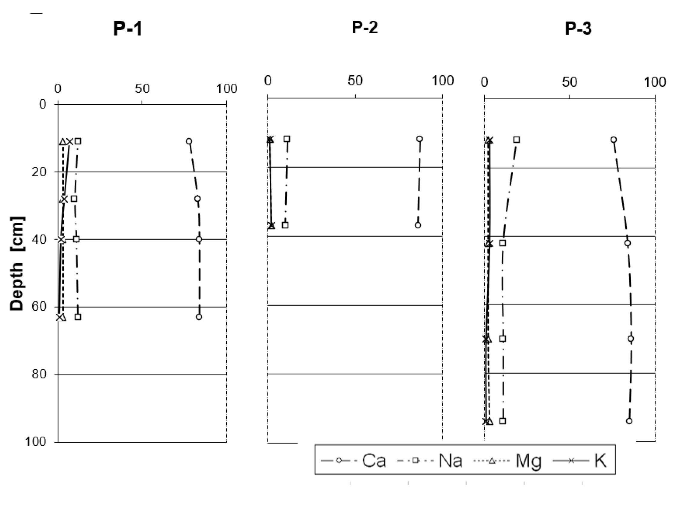

Table 1.
Localization of the soil profiles GPS–84.
| Profile | Altitude (meters above sea level) | Latitude N | Longitude E |
|---|---|---|---|
| P-1 | 392 | 49°10491 | 21°29521 |
| P-2 | 347 | 49°10597 | 21°29886 |
| P-3 | 336 | 49°10582 | 21°29973 |
| P-4 | 325 | 49°10539 | 21°30121 |
Table 2.
Sequential extraction of iron according to Tessier et al., (1979).
| Fraction | Extractor |
|---|---|
| FeI ion-exchangeable | 1M MgCl2, pH 7,0 |
| FeII carbonate | 1M NaOAc, pH 8,2 |
| FeIII oxide | 0,04M NH2OHHCl |
| FeIV organic + sulfide | 1) 0,02 M HNO3 + 30% H2O2, pH 2,0 2) 30% H2O2, pH 2,0 3) 3,2 M NH4AcOH |
| FeV other | HF + HClO4 |
Table 3.
General characteristics of studied rendzinas in topo-sequencing.
| Profile Localization |
Genetic horizon |
Depth (cm) |
Skeleton | Share of fraction | Color | CaCO3 (%) |
Co ( %) |
N g kg-1 |
C/N | |||
|---|---|---|---|---|---|---|---|---|---|---|---|---|
| Φ > 2 mm (%) |
Sand | Dust | Silt | (dry) | ||||||||
| (%) | ||||||||||||
|
P-1 Hilltop |
Ap | 0–23 | 30 | 32 | 53 | 15 | 2,5 YR 3/3 | 4.2 | 1.41 | 1.76 | 8.01 | |
| A/Cca | 23–33 | 50 | 15 | 54 | 31 | 2.5 YR 4/4 | 23.6 | 0.73 | 1.01 | 7.23 | ||
| A/Cca2 | 33–48 | 30 | 14 | 56 | 30 | 2.5 YR 4/4 | 32.2 | 0.46 | 0.69 | 6.67 | ||
| Cca | 48–76 | 30 | 17 | 50 | 33 | 2.5 YR 4/5 | 32.4 | – | – | – | ||
| P-2 Slope |
Ap | 0–25 | 50 | 25 | 49 | 26 | 2.5 YR 5/5 | 26.1 | 1.31 | 1.95 | 6.72 | |
| RcaCca | 25–48 | 80 | 28 | 43 | 29 | 2.5 YR 6/7 | 56.5 | 0.94 | 1.27 | 7.39 | ||
| P-3 Slope |
Ap | 0–30 | 15 | 16 | 51 | 33 | 2.5 YR 5/5 | 28.7 | 1.22 | 1.82 | 6.70 | |
| A/C | 30–55 | 10 | 15 | 52 | 33 | 2.5 YR 5/6 | 40.0 | 0.59 | 0.88 | 6.70 | ||
| Cca2 | 55–87 | 15 | 8 | 54 | 38 | 2.5 YR 6/7 | 48.2 | – | – | – | ||
| Cca3 | 87–100 | 30 | 13 | 54 | 33 | 2.5 YR 6/7 | 53.2 | – | – | – | ||
| P-4 Bottom |
Ap | 0–25 | 5 | 15 | 56 | 29 | 2.5 YR 3/3 | 2.3 | 1.11 | 1.63 | 6.81 | |
| Bw | 25–59 | – | 13 | 60 | 27 | 2.5 YR 3/3 | 1.0 | 0.84 | 1.21 | 6.94 | ||
| Bw/C | 59–80 | – | 12 | 59 | 29 | 2.5 YR 5/6 | 1.2 | 0.61 | 0.92 | 6.63 | ||
| Bw/C2 | 80–105 | – | 13 | 64 | 23 | 2.5 YR 5/6 | 3.8 | 0.55 | 0.84 | 6.55 | ||
| CG | 105–115 | – | 23 | 53 | 24 | 2.5 YR 4/3 | 13.3 | – | – | – | ||
Table 4.
Physicochemical properties of soils in separated genetic horizons.
| Genetic horizon |
pH | Hh | S | T | V | ||
|---|---|---|---|---|---|---|---|
| H2O | 1MKCl | cmol(+) kg-1 | (%) | ||||
| P-1 | Ap | 7.82 | 7.15 | 0.15 | 9.30 | 9.45 | 98.4 |
| A/Cca | 8.14 | 7.32 | 0.15 | 9.00 | 9.15 | 98.3 | |
| A/Cca2 | 8.29 | 7.44 | - | 9.81 | 9.81 | 100.0 | |
| Cca | 8.59 | 7.50 | - | 9.24 | 9.24 | 100.0 | |
| P-2 | Ap | 7.84 | 7.26 | 0.15 | 10.28 | 10.43 | 98.6 |
| RcaCca | 8.50 | 7.68 | - | 8.84 | 8.84 | 100.0 | |
| P-3 | Ap | 8.09 | 7.27 | 0.45 | 10.37 | 10.82 | 95.8 |
| A/C | 8.33 | 7.39 | 0.30 | 9.71 | 10.01 | 97.0 | |
| Cca2 | 8.61 | 7.57 | - | 8.97 | 8.97 | 100.0 | |
| Cca3 | 8.76 | 7.61 | - | 8.97 | 8.97 | 100.0 | |
| P-4 | Ap | 8.26 | 7.21 | 0.15 | 8.13 | 8.28 | 98.2 |
| Bw | 8.32 | 7.03 | 0.45 | 8.68 | 7.13 | 93.7 | |
| Bw/C | 8.29 | 7.20 | 0.30 | 9.68 | 9.98 | 96.9 | |
| Bw/C2 | 8.41 | 7.25 | - | 9.31 | 9.31 | 100.0 | |
| CG | 8.51 | 7.48 | - | 9.61 | 9.61 | 100.0 | |
Table 5.
Water-air properties of soils in separated genetic horizons.
| Profile |
Horizon | Humidity (% m) |
Hygroscopic water (%) |
Density g cm-3 |
Specific density g cm-3 | Total porosity (%) |
|---|---|---|---|---|---|---|
| P-1 | Ap | 13.2 | 3.77 | 1.35 | 2.51 | 46.2 |
| A/Cca | 14.7 | 3.04 | 1.41 | 2.44 | 42.2 | |
| A/Cca2 | 14.4 | 2.60 | 1.48 | 2.47 | 40.1 | |
| Cca | 16.4 | 2.37 | 1.50 | 2.45 | 38.8 | |
| P-2 | Ap | – | – | – | – | – |
| RcaCca | – | – | – | – | – | |
| P-3 | Ap | 11.4 | 4.41 | 1.31 | 2.45 | 46.5 |
| A/C | 12.6 | 3.22 | 1.43 | 2.43 | 41.1 | |
| Cca2 | – | – | – | – | – | |
| Cca3 | 13.5 | 3.54 | 1.50 | 2.49 | 39.8 | |
| P-4 | Ap | 19.7 | 5.31 | 1.27 | 2.43 | 47.7 |
| Bw | 22.4 | 4.55 | 1.34 | 2.40 | 44.2 | |
| Bw/C | 23.1 | 4.48 | 1.38 | 2.47 | 44.1 | |
| Bw/C2 | 26.8 | 4.83 | 1.58 | 2.52 | 37.3 | |
| C/G | – | – | – | – | – |
Table 6.
Content of iron and its fractions in separated genetic horizons of studied soils.
| Profile |
Horizon | Fet (%) |
Fraction | Ratios | |||||
|---|---|---|---|---|---|---|---|---|---|
| FeI | FeII | FeIII | FeIV | FeV | FeIII/Fet | FeIV/Fet | |||
| mg kg-1 | g kg-1 | (%) | (%) | ||||||
| P-1 | Ap A/Cca A/Cca2 Cca |
3.79 | 0.05 | 1.95 | 1.32 | 0.26 | 37.5 | 3.48 | 0.69 |
| 3.71 | 0.07 | 1.24 | 1.36 | 0.07 | 34.6 | 3.66 | 0.19 | ||
| 4.23 | 0.06 | 1.94 | 1.15 | 0.05 | 43.8 | 2.72 | 0.12 | ||
| 4.50 | 0.06 | 2.93 | 1.18 | 0.05 | 46.1 | 2.62 | 0.11 | ||
| P-2 | Ap RcaCca |
3.93 | 0.08 | 0.15 | 0.84 | 0.06 | 40.1 | 2.14 | 0.15 |
| 3.98 | 0.08 | 0.16 | 0.46 | 0.01 | 38.6 | 1.16 | 0.02 | ||
| P-3 | Ap A/C Cca2 Cca3 |
3.86 | 0.08 | 0.15 | 0.89 | 0.11 | 38.2 | 2.30 | 0.28 |
| 3.64 | 0.06 | 0.31 | 0.71 | 0.05 | 34.1 | 1.95 | 0.14 | ||
| 4.07 | 0.07 | 0.39 | 0.51 | 0.02 | 41.3 | 1.25 | 0.05 | ||
| 4.46 | 0.07 | 0.80 | 0.79 | 0.02 | 45.3 | 1.77 | 0.04 | ||
| P-4 | Ap Bw Bw/C Bw/C2 CG |
3.13 | 0.05 | 1.30 | 1.60 | 0.42 | 28.3 | 5.11 | 1.34 |
| 3.28 | 0.08 | 0.72 | 1.65 | 0.23 | 30.1 | 5.03 | 0.70 | ||
| 1.82 | 0.06 | 0.69 | 1.58 | 0.21 | 16.2 | 8.68 | 1.15 | ||
| 1.88 | 0.08 | 0.94 | 1.06 | 0.16 | 17.3 | 5.64 | 0.85 | ||
| 1.94 | 0.07 | 0.31 | 0.87 | 0.05 | 17.8 | 4.48 | 0.26 | ||
Fet – total, FeI – ion-exchangeable, FeII – carbonate, FeIII – oxide, FeIV – organic + sulfide, FeV – other.
Disclaimer/Publisher’s Note: The statements, opinions and data contained in all publications are solely those of the individual author(s) and contributor(s) and not of MDPI and/or the editor(s). MDPI and/or the editor(s) disclaim responsibility for any injury to people or property resulting from any ideas, methods, instructions or products referred to in the content. |
© 2025 by the authors. Licensee MDPI, Basel, Switzerland. This article is an open access article distributed under the terms and conditions of the Creative Commons Attribution (CC BY) license (http://creativecommons.org/licenses/by/4.0/).
Copyright: This open access article is published under a Creative Commons CC BY 4.0 license, which permit the free download, distribution, and reuse, provided that the author and preprint are cited in any reuse.


