Submitted:
15 February 2023
Posted:
16 February 2023
You are already at the latest version
Abstract
Agricultural production needs technologies that assist the management of natural resources, for example, the collection of real-time data on soil, water, weather, crops, and biodiversity conditions. Sensor technology solutions and open-source software are appropriate for promoting more sustainable agricultural production. Among the advantages of using open-source technologies and software is its potential for extension, collaboration, customization, flexibility, maintenance cost, transparency, speed, and better security. Given the above, the objective of this research was to find, in different electronic databases, exclusively open-source software for precision agriculture, offering a systematic review, and addressing considerations and challenges. This survey considers up-to-date open-source software available in repositories such as GitHub and GitLab, to understand its characteristics and application formats.
Keywords:
precision agriculture
; open source software
; open source technologies
1. Introduction
Open source applications for precision agriculture are becoming increasingly popular as they offer an affordable and accessible alternative to proprietary systems. These applications provide farmers with access to data and tools that can help them make informed decisions about their crops and land management. Open source applications for precision agriculture can also help farmers to better monitor and manage their resources, as well as to increase their yields and reduce their environmental impact. Additionally, open source applications can be used to develop innovative solutions to address specific challenges in the agricultural sector (Doering et al., 2016). These technologies, or innovative solutions, have been improved by incorporating software, hardware, and data (Aravind et al., 2017).
Precision agriculture is an individualized management concept for cultures, seeking different ways to explore and understand existing imbalances. Through the application of such technologies, it is possible to identify issues and better explore these cultures (Bhat & Huang, 2021). Precision agriculture can be seen as a subsection of precision practices facilitated by technological advances (Addicott, 2019). Precision practices take place in four main stages: data collection, planning, implementation, and culture management (Bhat & Huang, 2021).
Increasingly, agricultural production requires open source technological applications that are subject to precision practices (Cisternas et al., 2020). Information and communication technology (ICT) solutions, such as artificial intelligence (AI), machine learning, and the Internet of Things (IoT), are being used to improve the efficiency and accuracy of agricultural processes. AI can be used to monitor crop health, detect pests, and predict crop yields. Machine learning can be used to analyze large datasets and identify patterns in agricultural data. IoT can be used to connect different devices and sensors in the field to provide real-time data and insights into crop health, soil conditions, and weather patterns (Matilla et al., 2020).
There are several options in terms of technologies and open source software for precision agriculture, and selecting a context-appropriate technological tool from among those available can be crucial in obtaining good results (Sargent, 2020). Therefore, technology transfers of open source software can be an essential and transformative activity for precision agriculture, bridging the gap between theory and reality (Raeth, 2021).
The selection of open source software for agricultural purposes is based on a number of factors, such as its technical features, cost, maintenance burden, user-friendliness, documentation, security, and compatibility with existing systems (Lenarduzzi et al., 2020; Cisternas et al., 2020). In essence, it is essential to ensure that the software is able to meet the requirements of the agricultural sector and is able to handle the data and tasks efficiently.
According to De Oca & Flores (2021), the development of open source software aimed at precision agriculture has grown thanks to the involvement of three main technologies: computer vision, drones, and AI. Recently, a series of studies also propose using sensors to monitor production, improving the quality and quantity of crop data, and allowing, together with the appropriate software, to provide information, reminders and alerts to farmers (Martini, et al., 2021).
In order to ensure the success of these initiatives, it is important to understand the needs of the farmers, the existing infrastructure and the available technologies. Additionally, it is essential to identify the most suitable and cost-effective solutions to meet the requirements of the farmers and to ensure that the data collected is accurate, secure and reliable. Finally, it is necessary to develop strategies to ensure that the data collected is used to improve the efficiency of the agricultural production process (Dos Santos et al., 2022).
Given this context, we investigated which technologies and open source software are available for concrete problems in precision agriculture. In order to understand current demands, we searched electronic databases with the purpose of identifying applications and their characteristics, understanding the hardware and software relationships, as well as highlighting the programming languages used in their development and integration. The most common technologies used in precision agriculture are GPS, GIS, remote sensing, and variable rate technology. GPS is used to provide location data for mapping and navigation, while GIS is used to store, analyze, and visualize spatial data. Remote sensing is used to collect data from the environment, such as soil moisture and crop health. Variable rate technology is used to apply inputs, such as fertilizers and pesticides, at varying rates depending on the needs of the crop. These technologies can be used together to create precision farming systems that are tailored to the specific needs of a farm. Open source software can be used to leverage these technologies, creating precision farming systems. It is freely available and can be modified and redistributed. This makes it an attractive option for farmers who want to customize their precision farming systems to their specific needs. Open source software can also be used to create tools that allow farmers to collect, analyze, and visualize data in a cost-effective way. Overall, understanding the available technologies for precision practices is essential for farmers who want to maximize the efficiency and productivity of their farms.
This paper is organized as follows. Section 2 presents the materials and methods used in this review, namely, data sources, filtering procedures, sorting of collected data, and mapping of selected works. Section 3 presents the research results, i.e., the applications addressed in this review. Section 4 offers a discussion and critical analysis of this research. Finally, Section 5 puts forward our final considerations and future work suggestions.
2. Materials and Methods
This section presents the classification procedures that describe the steps of the systematic review of literature related to the investigated topic (Kitchenham & Charters, 2007). This systematic review addresses recent projects and limits itself to presenting only open source technologies and software for precision agriculture practices, excluding software with a proprietary license of use. Therefore, in sections 2.1 to 2.4, the structure of the research is presented, where we define a search string (allowing the identification of the most relevant scientific works), the filtering procedures, as well as the inclusion and exclusion criteria for publications.
2.1. Search Protocol
In this subsection, a search protocol is presented, as well as the data sources in which the most relevant publications are to be found. From these publications, those that address open source software focused on precision agriculture are sought. The research was carried out between January and October 2022. In this sense, the works will be identified by a search string applied in electronic data sources.
The search string is as follows:
(“open source software” and “precision agriculture”)
The electronic data sources are:
- Google Scholar: https://scholar.google.com
- GitHub: https://github.com
- GitLab: https://gitlab.com/
Searchable databases such as GitHub and GitLab are open source software repositories, and Google Scholar is a free and accessible search engine that organizes a variety of scientific scholarly publication formats.
After defining the search string and the data sources to be searched, the key terms corresponding to each of the search sources were also created. Key terms are defined junctions within the search string and separated by quotes. Table 1 presents the databases, the respective search strings, and the number of results obtained. Some tweaks within the search strings column are also presented. In the Google Scholar database row, exclusion attributes are added, and, in the GitHub and GitLab database rows, search strings were defined and carried out by topic.
This systematic review includes applications and software available in repositories such as GitHub, GitLab or similar, and preferably with an associated scientific publication.
2.2. Filtering Procedures
After defining the search string for each database, it was necessary to create and define the filtering procedures, according to the inclusion and exclusion criteria.
- Inclusion criteria
The disposition of the inclusion topics was any work focused on precision agriculture that addresses or consists of open source software, also respecting the following conditions:
- Works published between the years 2012 to 2022;
- Works only in the English language;
- Complete open source works made available in repositories such as GitHub, GitLab or equivalent;
- Source code of the software or application found on GitHub and GitLab that has been updated at least once in the last 3 years (counting down from October 2022).
- Exclusion Criteria
Three exclusion criteria were defined, namely:
- Applications not directly related to precision agriculture;
- Farming simulator applications, farm simulator games;
- Other games.
2.3. Sorting
This section describes the steps taken to sort the data collection and map the works found, based on the filtering criteria and, thus, select the most relevant publications to the theme of this research.
2.3.1. Data Collection
Table 2 presents the quantification of the works found in their respective electronic databases. Where 249 articles were identified on Google Scholar and 59 works distributed in repositories such as GitHub and GitLab, ending with the identification of a total of 308 publications. The sorting of works takes place by applying the filtering criteria, after which, 234 works from the Google Scholar database and 53 works from the GitHub and GitLab databases were excluded, in a total of 287 excluded works. The works included are then presented, of which 16 are from the Google database and 6 are from the GitHub databases. Therefore, a new scenario is presented with 21 works corresponding to the proposal defined in the research objectives.
2.4. Mapping
The mapping of selected works is detailed in Table 3. The selected works were mapped and their reading can be done by indications such as data sources, title, interfaces, category, programming language, authors, and links to repositories. The interfaces, which define the way of interacting with the software in question, can be graphical interfaces, text interfaces, libraries, or just a plugin for another tool. Technology and software applications were grouped according to the following categories:
A - Crop and climate protection and diagnosis;
B - Nutrition and fertilization of crops;
C - Crop irrigation;
D - Soil management, planting, growing and harvesting crops;
E – Production management, machinery and equipment.
Some applications, due to their varied number of features, fall into more than one category. In this case, they were placed in the category corresponding to their main functionality and purpose. In the next section, we discuss each of the applications individually.
3. Results
In this section, the results obtained from the literature related to the subject of study are presented. Various applications found throughout this research are grouped according to the categories mentioned in Section 2.4. For each software, a brief description is presented, highlighting its main characteristics and functionalities, while its potential of use is framed and contextualized within the various categories of precision agriculture.
3.1. A - Crop and Climate Protection and Diagnosis
Winkler (2021) presents the MeteoMex project (Table 3, item 2), which aims to integrate current IoT platforms for community-oriented environmental monitoring. This monitoring helps to protect natural resources such as water and energy, as well as detect timely health risks and improve the quality of food production. The use of low-cost mini-boards connected to environmental sensors from the Things Board open source platform1 is demonstrated. Programmed in Arduino C with WiFi capability, MeteoMex can be deployed for monitoring air and soil quality. The authors also discuss a prototype to monitor effluent treatment. It uses a PostgreSQL database with the goal of simplifying the process of data mining. It is considered highly scalable and cost-effective, and may be suitable for deployment in precision agriculture, industry contexts, and public areas. As examples of concrete cases, the following are described: monitoring ambient air at the national institute of respiratory diseases in Mexico, monitoring greenhouses (air and soil), monitoring air conditioning in a high-performance computer room, and monitoring domestic wastewater stations.
Arunachalam & Andreasson (2022) propose a continuous crop monitoring system called smart AGRO IoT (Table 3, item 6). The system automates the deployment of sensors and storage, providing an elegant dashboard for visualizing the continuous stream of real-time data. The system has a sensor data acquisition mechanism, collecting data in a continuous fashion, and is easy to implement in growth chambers and greenhouses. Figure 1 shows its configuration on an agricultural test bench. The system can be extended to farms with specific configurations, while its instances are heterogeneous in terms of configuration and installation. The proposed solution, based on Raspberry Pi or Arduino hardware, is scalable and provides stability in monitoring any environment. The system is functional in x, y and z axes along the rails with transverse slides. Soil loosening, digging and seeding can be performed with a robot arm by providing x and y coordinates as location points via the program’s interface. Once the coordinates are specified, the robot arm is moved to the location point and sowing starts with the digging operation, after which the seeds are sown.
Boubin & Stewart (2020) present the SoftwarePilot middleware, (Table 3, item 9), used in fully autonomous precision agriculture applications. The system provides data detection and flight control utilities, allowing users to customize machine learning models for pathfinding, object detection, and data analysis. The work discusses the subcomponents of the SoftwarePilot microservices design, namely the routines and drivers, and how they can be used to control UAV flights autonomously and in data sensing. An interactive coding session is also featured, teaching how to develop a simple application. Finally, the authors report that the system has been used to process thousands of images captured autonomously in agricultural missions.
Onsongo et al. (2022) developed the Integrated Tool for AgData Lat Long Imputation and Cleaning (ITALLIC) system (Table 3, item 13), which detects and corrects errors in location data by imputing missing values to location-dependent data. An open source API is used to geocode the location. The system, developed in Python, includes a visualization tool that facilitates the validation of results by the user by plotting the original and corrected locations on a map.
Qin et al. (2021) propose Ag-YOLO (Table 3, item 14), a low-cost real-time detector for pulverization applied to case studies with palm trees. The software developed and presented in this study is adapted for use in embedded RGB camera systems. With the increasing availability of drones that can spray pesticides, the included algorithm can contribute to selective pulverization. The system receives as input the images acquired by an on-board camera and sends the instructions to the flight management unit in real time, achieving better levels of accuracy and representation power, both in terms of computation cost and memory usage. This seeks to save and reduce the environmental impact and economic costs to the farmer. According to the author, the technology is low-cost and necessary for the widespread use of target-oriented selective spraying.
Maldaner et al. (2021), present the MapFilter 2.0 software (Table 3, item 16), developed to analyze and remove inconsistent data in high-density agricultural datasets. The authors claim that the software is easy to install and has a friendly interface (Figure 2), helping users to generate reliable maps of the areas of cultivation based on the optimization of data quality. The project, developed in the Java language, performs a visual analysis of the data and reapplies the global and local filtering with other input values. All statistical analyses were performed in the R software (R Core Team, 2018) using the gstat library (Gräler et al., 2016). The developed application demonstrated the potential for practical use of spatial data filtering and received Brazilian patent No. BR512019002014-6.
3.2. B - Crop nutrition and fertilization
Wang et al. (2021) present EasyIDP (Table 3, item 5), an open source software package, developed with the aim of reducing the workload in processing raw image data obtained from UAVs. The focus of the package is on agricultural applications, since drone photometry techniques are widely used for phenotyping high-yielding plants. Six field datasets with different crop characteristics were selected to develop and test the performance of the proposed package. The tool has considerable potential in reducing the computational load in data annotations for machine learning applications. According to the authors, results showed that the tool works as expected, both in cropping and reversing tasks tested on a variety of crops.
3.3. C - Crop irrigation
Irrigation management can achieve better ways of using water resources in the context of precision agriculture, and is one of the most important and complex steps in plantation environments (dos Santos et al., 2022). In this sense, with precision irrigation, farmers seek to address drought situations, minimizing the use of water without devaluing the crop. It is possible to estimate the water needs for a crop through a set of equations extracted from the physics of evapotranspiration (Raeth, 2020). Other irrigation systems use intelligent approaches for different crops in greenhouses, allowing, for example, to autonomously activate or deactivate the water supply system depending on the environmental conditions and soil moisture (Hernández et al., 2021).
An application for Android smartphones called EVAPO is presented by Júnior et al. (2019) (Table 3, item 11), the objective of which is to estimate evapotranspiration in real time, anywhere in the world, increasing water conservation and seeking more efficient irrigation. It uses climate data from conventional surface weather stations. The app is available for free on the Play Store. The results presented in this study conclude that the data can be used reliably, estimating evapotranspiration and enabling its applicability to smartphones. The performance of the proposed method was evaluated, comparing the evapotranspiration power, estimated by EVAPO using climate data from conventional surface stations in various locations around the world. The agrometeorological data used from these stations were average, maximum and minimum air temperature, relative humidity, insolation and wind speed.
Carrillo-Pasiche et al. (2022) present an irrigation system for urban areas based on IoT (Table 3, item 7). The system analyzes important factors for an effective irrigation process, considering the use of water in an economical and viable way. In this sense, a prototype was developed with Arduino Uno, connected to sensors and driven by a web application called HydroTi, capable of determining when to irrigate and how much water to use. The solution was evaluated by comparing the different types of irrigation in order to determine the water consumption and validating its effectiveness.
Raeth (2020) presents a system (Table 3, item 19) that calculates irrigation needs in crops based on information specific to the crop, soil, terrain and climatic conditions. The system allows the development of the irrigation schedule for different management conditions and the calculation of the water supply scheme for different cultivation patterns. Furthermore, the system can also be used to evaluate farmers’ irrigation practices and estimate crop performance under irrigation conditions. The software uses meteorological data and evapotranspiration equations to demonstrate an approach to limiting the amount of water withdrawn for irrigation. The software is written in C++ and can be embedded in human-supervised but fully automated irrigation controllers.
De Oca & Flores (2021a) present the development of an unmanned aerial system to capture and process vegetation index thermal images (Table 3, item 12). This index is used to determine water stress and evaluate the irrigation process. An interface based on the Raspberry Pi was also designed, collecting the necessary images by means of a thermal camera. The entire image correction process has a significant impact in increasing the quality of the orthomosaic. To generate the orthomosaic from the aerial images, the WebODM2 software was used. Temperature calibration works by applying a linear model for temperature estimation and the vegetation index is calculated from the corrected and calibrated images. The authors, based on the experimental results, state that the proposed system works well for its intended purposes.
3.4. D - Soil management, planting, growing and harvesting the crop
De Freitas Coelho et al. (2018) present an embedded system to perform an analysis of spatial variability data shortly after its acquisition in the field (Table 3, item 10). Sampling strategies typically happen manually and make the analysis process difficult. To avoid these problems, the proposed software solution performs the analysis immediately after collection. Hardware with sensor communication ports and good processing power is suggested. The system was developed in Python, and, according to the authors, proved to be efficient with tests in soybean planting, while the comparison of the generated maps demonstrated the importance of filtering the data before analyzing it.
De Oca & Flores (2021b) propose the AgriQ system (Table 3, item 4), an Unmanned Aerial System (UAS) for precision agriculture. The design, which includes both hardware and software, allows for a flexible, low-cost approach. The experiments carried out took place in two different vegetation areas with 8 vegetation indices. Qualitative and quantitative comparisons were made to assess the quality of the system versus a commercial application. The main advantage found was the smaller amount of images required to reconstruct a map, resulting in a reduction of computational load and processing time.
Rogers & Fox (2020) present a terrestrial robot designed to move autonomously, being able to store the geospatial location of each seed with precision (Table 3, item 1). The robot platform was designed to plant seeds with greater precision, within the georeferenced line. The system can plan and control an efficient point-to-point route, including accelerating on long straight lines and slowing down on corners. Through a geospatial location module, the robot stores the coordinates of each planted seed so that it can return to it. According to the performed experiments, the authors claim that the differential location accuracy is such that driving the robot to revisit specific plants is possible for seed spacings up to 139 mm.
Coleman (2022) developed the OpenWeedLocator (OWL) project with the aim of maximizing crop yield potential in agricultural environments with limited humidity and a focus on weed removal (Table 3, item 3). The system integrates weed detection on a Raspberry Pi with a relay control board that mounts on robots and vehicles for timely spraying. Four color-based algorithms that exploited the green color levels of weeds for detecting them were used to validate the hardware. All image processing software was written in Python, making use of OpenCV (Bradski, 2000) and NumPy (Harris et al., 2020), as well as several other libraries.
Jiménez-Jiménez et al. (2022) present the VICAL system (Table 3, item 15), an open source tool to calculate maps used in agricultural applications, as well as time series of any agricultural area in the world, leveraging data from the Landsat and Sentinel-2 satellites. The system was implemented in JavaScript and developed on the free Google Earth Engine platform. The tool can be beneficial for users with poor access to satellite data or lack of computing infrastructure to handle large volumes of data. To evaluate the performance of the VICAL system, individual images were downloaded from agricultural stations in two irrigation districts in Mexico, located in the north of Sinaloa state and in the Lagunera region, respectively. According to the authors, this system can save time and prevent error-prone repetitive and trivial procedures, associated with manual calculations.
3.5. E - Management of production, animals, machinery and equipment
Plenio et al. (2021) present an application called Bovine Heat Detection and Analysis Tool (BovHEAT), an open source analysis tool to process data from automated systems and activity monitoring in dairy cattle (Table 3, item 18). Activity data is collected by an accelerometer attached to the animal’s neck, which is now widely used in the dairy industry. Developed with the Python programming language, BovHEAT offers fully automatic and scalable processing, and is able to output data in various formats. The advantages of this tool are in obtaining a better understanding of the physiology and behavior of dairy cows and in supporting decision-making in optimizing reproductive management. Two different data sets of 8 farms were used: 1 farm in Canada and 7 farms in Germany. Its validation was carried out independently by three researchers involved in the project. Activity data from 60 cows were used, representing a total number of 600 observations per cow, with results indicating that the system requires less user interaction and speeds up data processing.
Leroux et al. (2018) present the GeoFIS software (Table 3, item 8). The purpose of this tool is to support the entire process of precision agriculture, from spatial data to spatial information and decision support. It was designed with a user-friendly interface with the intention of supporting users with no programming skills. Experiments were carried out in three types of crops: banana, wheat and vineyards. These were chosen to highlight the diversity of applications and data characteristics that can be handled with GeoFIS. The analysis of the three types of crops was an opportunity to also assess the limits of the algorithms and propose new areas for future developments within the tool itself.
Muenchow et al. (2017) present RQGIS (Table 3, item 21), an integration of R with the open source QGIS system for statistical geocomputing and geographic information systems (QGIS Development Team, 2022). The proposal extends the statistical resources of R with numerous geoprocessing and data manipulation tools available in a geographic information system (GIS). The combination of R and GIS software creates a powerful environment for geocomputing and advanced statistics. RQGIS supports R named data, seamless exchange of spatial data types, and quick access to a broad suite of geoalgorithms for solving many GIS problems, among which the authors highlight those related with precision agriculture. However, continuous development of QGIS led to a number of unsolvable issues in RQGIS, which has since been deprecated according to its repository. The qgisprocess3 package seems to be the natural successor for the functionality previously offered by RQGIS, but is, at time of writing, in an experimental stage.
Mazzia et al. (2021) present a model capable of managing and globally estimating a path with a series of points that an autonomous vehicle, both land and air, can follow (Table 3, item 20). A Deep Learning model capable of predicting the position of the main paths from the destination was designed and trained. Extensive experimentation, with synthetic datasets and real satellite-derived images of different scenarios, used in vineyard and orchard plantations, demonstrates the effectiveness and feasibility of the methodology as a completely autonomous approach to end-to-end global path planning.
Finally, Rentadrone (2020) proposes AI Agro, a set of machine learning algorithms for determining the health of various types of crops (Table 3, item 17). The provided solutions integrate data obtained from temporal, mosaic, multispectral, and thermal imaging, yielding outputs such as thermal maps and normalized vegetation index maps, which allow the identification of stress zones. The solutions can generate local calculations and plant-by-plant mapping of vegetation indices by processing images obtained by drones. According to the authors, the included algorithms can perform batch processing of photo files, JPG and TIFF images, and are capable of mapping the health status of different types of crops visible in multispectral photographs taken with drones. Thus, the software is also capable of calculating the main types of vegetation index.
4. Discussion
In this section, a discussion about the applications addressed in this work is presented, according to the parameters used for comparison in Table 3. A total of 21 applications were presented and the parameters considered are the following: the sources consulted, the titles of the works, their user interfaces, the categories and operations, the adopted programming language(s), the authors and electronic addresses of their repositories.
The information reported in this discussion is necessary to understand the standards and guidelines that open source software aimed at precision agriculture point to, summarizing the results obtained in this research. Figure 3 presents the number of works published per year in the last 6 years. It can be seen by the dotted line (obtained with an ordinary least squares linear regression), a growth trend of works published on the theme of this research.
The works surveyed were developed using programming languages such as Python, C/C++, Java and JavaScript. In Figure 4 it is noted that the languages with Python, Java and C/C++ stand out among the rest, perhaps because the works present several projects with hardware integration with Arduino and Raspberry Pi, as well as data analysis by sensors.
However, it is possible to observe a certain tendency in the Python language, which is present in approximately 45% of the works found.
In Figure 5, we present the distribution of interfaces used to interact with end users. Four types of interface were defined in this research: text, graphic, library and plugin, which in some cases exist simultaneously. It appears that there is a balance of interfaces adopted between applications and software.
The variation between programming languages has a direct influence on this scenario, mainly due to the way these languages are used. The most adopted interface was graphical and secondly in the form of text or applied with the help of libraries, and finally the use of plugins. Applications and software use the most appropriate interface for their purpose and the type of end users.
The application context by category is presented in Figure 6, in which we observe that the category of soil management, planting, growing and harvesting (category D) corresponds to 23% of the works presented, while the protection, diagnosis of cultivation and climate (category A) appears with 32% of the tools found. In turn, the management of production, machinery and equipment (category E) is being represented by 23% of the tools found. The irrigation of crops (category C) appears represented with 18%, and crop nutrition and fertilization (category B) with 4%. There is an almost homogeneous distribution between most of the categories, with the exception of category B, indicating a growth space to be explored.
Regarding the researched sources, we note some advances in the provision of open codes in free repositories, making them available to academic communities, although it is still not common to do so. Many of the repositories are poorly managed, with commits uploaded directly to GitHub, repositories containing ZIPs and executables instead of pure code, as well as incomplete documentation. Items 6, 12 and 15 in Table 3 are a case in point.
5. Final Considerations
In this article, a systematic review of the literature on technologies and open source software aimed at precision agriculture was carried out. The works were selected, mapped and presented by their data sources, titles, their interface, the operation and application category, the language used for development, the authors involved and the links to the repositories.
To achieve the best ways of using available open source software for precision practices, it is possible that the contributions of this work could become a fundamental exercise in the debate on open source agriculture. The works found were grouped into five categories: A) protection, diagnosis of cultivation and climate; B) crop nutrition and fertilization; C) crop irrigation; D) soil management, planting, growing and harvesting crops; and, E) management of production, machinery and equipment. In this way, the interpretation of users who seek to understand the applicability of the presented open source software is facilitated.
The study of this research advances the understanding of open source software aimed at precision agriculture and its availability. It is possible to conclude that open source software can lead to excellent results in the field, especially in situations where there is more than one success case for each software and when the existence of libraries and open code software leads to even more and better solutions being created. The practices adopted by the authors were presented, pointing to the need to expand these open source technologies and their advantages, thus improving the quality of agricultural production and avoiding damage to the environment and agriculture.
It is expected that future open source applications and software will be available in public repositories, such as those made available by GitHub and GitLab, enabling testing and their improvements by the entire community involved and that believes in the quality of open source software aimed at precision agriculture.
As future work, it is intended to test applications that use simulators and understand the variables used, better understand the hardware integration and the exchange of data generated between these different technologies, filtering the works that are dealing with the subject of artificial intelligence, offering the prediction as results and in real time.
| 1 | |
| 2 | |
| 3 |
References
- Addicott, J. E. The precision farming revolution: global drivers of local agricultural methods. Springer Nature, 2019. ISBN 978-981-13-9685-4. [CrossRef]
- Aravind, K., Subramanian, R. B., Subramanian, V. S., Srivyassram, V., Hayakawa, Y., \& Pandian, S. R.”An affordable build-your-own computer control system for electropneumatics education.” 2017 Conference on Information and Communication Technology (CICT). IEEE, 2017. [CrossRef]
- Arunachalam, A., & Andreasson, H. “RaspberryPi Arduino (RPA) powered smart mirrored and reconfigurable IoT facility for plant science research.” Internet Technology Letters 5.1 (2022): e272. [CrossRef]
- Bazzi, C. L., Jasse, E. P., Magalhães, P. S. G., Michelon, G. K., de Souza, E. G., Schenatto, K., & Sobjak, R. (2019). AgDataBox API–Integration of data and software in precision agriculture. SoftwareX, 10, 100327. [CrossRef]
- Bhat, S. A., & Huang, N. F. “Big data and AI revolution in precision agriculture: Survey and challenges.” IEEE Access 9 (2021): 110209-110222. Bhat, S. A., & Huang, N. F. “Big data and AI revolution in precision agriculture: Survey and challenges.” IEEE Access 9 (2021): 110209-110222. [CrossRef]
- Boubin, J., & Stewart, C.”SoftwarePilot: Fully Autonomous Aerial Systems Made Easier.” 2020 IEEE International Conference on Autonomic Computing and Self-Organizing Systems Companion (ACSOS-C). IEEE, 2020. [CrossRef]
- Boubin, J., Chumley, J., Stewart, C., & Khanal, S. “Autonomic computing challenges in fully autonomous precision agriculture.” 2019 IEEE international conference on autonomic computing (ICAC). IEEE, 2019. [CrossRef]
- Bradski, Gary. “The OpenCV library.” Dr. Dobb’s Journal: Software Tools for the Professional Programmer 25.11 (2000): 120-123. ISSN: 1044-789X.
- Burgstaller, S., Angermair, W., Migdall, S., Bach, H., Vlachopoulos, I., Savva, D.,... & Koubarakis, M. “LEOpatra: A Mobile Application for Smart Fertilization Based on Linked Data.” HAICTA. 2017.https://strabon.di.uoa.gr/files/haicta17.pdf.
- Carrillo-Pasiche, P., Miranda-Gutarra, A., & Ugarte, W. “HydroTi: An Irrigation System for Urban Green Areas using IoT.” 2022 IEEE XXIX International Conference on Electronics, Electrical Engineering and Computing (INTERCON). IEEE, 2022. [CrossRef]
- Cisternas, I., Velásquez, I., Caro, A., & Rodríguez, A. “Systematic literature review of implementations of precision agriculture.” Computers and Electronics in Agriculture 176 (2020): 105626. [CrossRef]
- Coleman, G., Salter, W., & Walsh, M. “OpenWeedLocator (OWL): an open-source, low-cost device for fallow weed detection.” Scientific Reports 12.1 (2022): 1-12. https://www.cabidigitallibrary.org/doi/pdf/10.31220/agriRxiv.2021.00074.
- de Freitas Coelho, A. L., de Queiroz, D. M., Valente, D. S. M., & de Carvalho Pinto, F. D. A. “An open-source spatial analysis system for embedded systems.” Computers and Electronics in Agriculture 154 (2018): 289-295. [CrossRef]
- de Oca, A. M., & Flores, G. “A UAS equipped with a thermal imaging system with temperature calibration for Crop Water Stress Index computation.” 2021 International Conference on Unmanned Aircraft Systems (ICUAS). IEEE, 2021a. [CrossRef]
- de Oca, A. M., \& Flores, G. “The AgriQ: A low-cost unmanned aerial system for precision agriculture.” Expert Systems with Applications 182 (2021b): 115163. [CrossRef]
- De Wit, A., Boogaard, H., Fumagalli, D., Janssen, S., Knapen, R., van Kraalingen, D.,... \& van Diepen, K. “25 years of the WOFOST cropping systems model.” Agricultural systems 168 (2019): 154-167. [CrossRef]
- Doering, D., Vizzotto, M., Bredemeier, C., da Costa, C., Henriques, R., Pignaton, E., \& Pereira, C.”MDE-based development of a multispectral camera for precision agriculture.” IFAC-PapersOnLine 49.30 (2016): 24-29. [CrossRef]
- Dos Santos, R. P., Beko, M. & Leithardt, V. R. Q.. “Modelo de Machine Learning em Tempo Real para Agricultura de Precisao.” Anais da XXII Escola Regional de Alto Desempenho da Região Sul. SBC, 2022. [CrossRef]
- Dos Santos, R. P., Leithardt, V. R. Q. & Beko, M. “Analysis of MQTT-SN and LWM2M communication protocols for precision agriculture IoT devices.” 2022 17th Iberian Conference on Information Systems and Technologies (CISTI). IEEE, 2022. ISBN: 978-989-33-3436-2.
- Giotitsas, C. Open source agriculture: Grassroots technology in the digital era. Springer Nature, 2019.ISBN: 978-3-030-29341-3.
- Gräler, B., Pebesma, E. & Heuvelink, G. (2016). “Spatio-Temporal Interpolation using gstat.” The R Journal, 8, 204-218. [CrossRef]
- Harris, C. R., Millman, K. J., van der Walt, S. J., Gommers, R., Virtanen, P., Cournapeau, D., Wieser, E., Taylor, J., Berg, S., Smith, N. J., Kern, R., Picus, M., Hoyer, S., van Kerkwijk, M. H., Brett, M., Haldane, A., del Río, J. F., Wiebe, M., Peterson, P., Gérard-Marchant, P., Sheppard, K., Reddy, T., Weckesser, W., Abbasi, H., Gohlke, C. & Oliphant, T. E. “Array programming with NumPy”. Nature 585, 357–362 (2020). [CrossRef]
- Hernández, E. S., García, A. G., Izquierdo, L. R., González, J. T., Silva, L. A., Ovejero, R. G., & Leithardt, V. R. Q. (2022). LoRaWAN applied to agriculture: A use case for automated irrigation systems. In New Trends in Disruptive Technologies, Tech Ethics and Artificial Intelligence: The DITTET Collection 1 (pp. 308-316). Springer International Publishing. DOI: 10.1007/978-3-030-87687-62-9.
- Jiménez-Jiménez, S. I., Marcial-Pablo, M. D. J., Ojeda-Bustamante, W., Sifuentes-Ibarra, E., Inzunza-Ibarra, M. A., & Sánchez-Cohen, I. “VICAL: Global Calculator to Estimate Vegetation Indices for Agricultural Areas with Landsat and Sentinel-2 Data.” Agronomy 12.7 (2022): 1518. [CrossRef]
- Júnior, W. M., Valeriano, T. T. B., & de Souza Rolim, G. “EVAPO: A smartphone application to estimate potential evapotranspiration using cloud gridded meteorological data from NASA-POWER system.” Computers and Electronics in Agriculture 156 (2019): 187-192. [CrossRef]
- Kaiser, K. E., Flores, A. N. & Vernon, C. R. “Janus: a Python package for agent-based modeling of land use and land cover change.” Journal of Open Research Software 8.PNNL-SA-148545 (2020).
- Kitchenham, B., & Charters, S. “Guidelines for performing systematic literature reviews in software engineering.” (2007).
- Lenarduzzi, V., Taibi, D., Tosi, D., Lavazza, L., & Morasca, S.”Open source software evaluation, selection, and adoption: a systematic literature review.” 2020 46th Euromicro Conference on Software Engineering and Advanced Applications (SEAA). IEEE, 2020. [CrossRef]
- Leroux, C. Jones, H., Pichon, L., Guillaume, S. Lamour, J. Taylor, J. Naud, O. Crestey, T. Lablee, J. L. & Tisseyre, B. “GeoFIS: An open source, decision-support tool for precision agriculture data.” Agriculture 8.6 (2018): 73. [CrossRef]
- Maldaner, L. F., Molin, J. P., & Spekken, M. “Methodology to filter out outliers in high spatial density data to improve maps reliability.” Scientia Agricola 79 (2021). [CrossRef]
- Mancini, M., Nassisi, P., Trabucco, A., Meloni, A., Toli, K., Bacciu, V., & Mereu, S. “An Open Source and Low-Cost Internet of Things-enabled Service for Irrigation Management.” 2019 IEEE International Conference on Systems, Man and Cybernetics (SMC). IEEE, 2019. [CrossRef]
- Martini, B. G., Helfer, G. A., Barbosa, J. L. V., Espinosa Modolo, R. C., da Silva, M. R., de Figueiredo, R. M.,... & Leithardt, V. R. Q. “IndoorPlant: A model for intelligent services in indoor agriculture based on context histories.” Sensors 21.5 (2021): 1631. [CrossRef]
- Matilla, D. M., Murciego, Á. L., Bravo, D. M. J., Mendes, A. S., \& Leithardt, V. R. Q. “Low cost center pivot irrigation monitoring systems based on IoT and LoRaWAN technologies.” 2020 IEEE International Workshop on Metrology for Agriculture and Forestry (MetroAgriFor). IEEE, 2020. [CrossRef]
- Mazzia, V., Salvetti, F., Aghi, D., & Chiaberge, M. “Deepway: a deep learning waypoint estimator for global path generation.” Computers and Electronics in Agriculture 184 (2021): DOI: 106091. [CrossRef]
- Michelon, G. K., Bazzi, C. L., Upadhyaya, S., de Souza, E. G., Magalhães, P. S. G., Borges, L. F., & Betzek, N. M. (2019). Software AgDataBox-Map to precision agriculture management. SoftwareX, 10, 100320. [CrossRef]
- Muenchow, J., Schratz, P., \& Brenning, A. “RQGIS: Integrating R with QGIS for Statistical Geocomputing.” R Journal 9.2 (2017). https://rjournal.github.io/archive/2017/RJ-2017-067/RJ-2017-067.pdf.
- Oliveira, R. A., Khoramshahi, E., Suomalainen, J., Hakala, T., Viljanen, N., & Honkavaara, E. “Real-time and post-processed georeferencing for hyperpspectral drone remote sensing.” The international archives of the photogrammetry, remote sensing and spatial information sciences (2018). [CrossRef]
- Onsongo, G., Fritsche, S., Nguyen, T., Belemlih, A., Thompson, J., & Silverstein, K. A. “ITALLIC: A tool for identifying and correcting errors in location based plant breeding data.” Computers and Electronics in Agriculture 197 (2022): 106947. [CrossRef]
- Plenio, J. L., Bartel, A., Madureira, A. M. L., Cerri, R. L. A., Heuwieser, W., \& Borchardt, S. “Application note: Validation of BovHEAT—An open-source analysis tool to process data from automated activity monitoring systems in dairy cattle for estrus detection.” Computers and Electronics in Agriculture 188 (2021): 106323. [CrossRef]
- Pretto, A., Aravecchia, S., Burgard, W., Chebrolu, N., Dornhege, C., Falck, T.,... & Nieto, J. “Building an aerial–ground robotics system for precision farming: an adaptable solution.” IEEE Robotics\Automation Magazine 28.3 (2020): 29-49. [CrossRef]
- Pudumalar, S., Ramanujam, E., Rajashree, R. H., Kavya, C., Kiruthika, T., & Nisha, J. “Crop recommendation system for precision agriculture.” 2016 Eighth International Conference on Advanced Computing (ICoAC). IEEE, 2017. [CrossRef]
- QGIS Development Team. QGIS Geographic Information System, 2022. Open Source Geospatial Foundation. http://qgis.org.
- Qin, Z., Wang, W., Dammer, K. H., Guo, L., & Cao, Z.. “Ag-YOLO: A Real-Time Low-Cost Detector for Precise Spraying With Case Study of Palms.” Frontiers in Plant Science 12 (2021): DOI: 753603-753603. [CrossRef]
- R Core Team (2018). “R: A language and environment for statistical computing”. R Foundation for Statistical Computing, Vienna, Austria. https://www.R-project.org/.
- Raeth, P. G. “Moving beyond manual software-supported precision irrigation to human-supervised adaptive automation.” African Journal of Agricultural Research 16.11 (2020): 1548-1553. DOI: https://doi.org/5897/AJAR2020.15178.
- Raeth, P. G. “Transition of soil-moisture estimation theory to practical application.” Journal of Engineering and Computer Innovations 6.1 (2021): 1-10. DOI: https://doi.org/10.5897/JECI2021.0202.
- Rentadrone, H. B. (2020). https://github.com/RentadroneCL/AI-Agro - Accessed on: 20 de janeiro de 2023.
- Riihiaho, K. A., Eskelinen, M. A., & Pölönen, I. “A do-it-yourself hyperspectral imager brought to practice with open-source python.” Sensors 21.4 (2021): 1072. [CrossRef]
- Rogers, H., \& Fox, C.”An open source seeding agri-robot.” Proceedings of The 3rd UK-RAS Conference. 2020. [CrossRef]
- Shafi, U., Mumtaz, R., García-Nieto, J., Hassan, S. A., Zaidi, S. A. R., & Iqbal, N. “Precision agriculture techniques and practices: From considerations to applications.” Sensors 19.17 (2019): 3796. [CrossRef]
- Tan, L., Haley, R., Wortman, R., & Zhang, Q. “An extensible and integrated software architecture for data analysis and visualization in precision agriculture.” 2012 IEEE 13th International Conference on Information Reuse & Integration (IRI). IEEE, 2012. [CrossRef]
- Wang, H., Duan, Y., Shi, Y., Kato, Y., Ninomiya, S., & Guo, W. “EasyIDP: a Python package for intermediate data processing in UAV-based plant phenotyping.” Remote Sensing 13.13 (2021): 2622. [CrossRef]
- Winkler, Robert. “MeteoMex: open infrastructure for networked environmental monitoring and agriculture 4.0.” PeerJ Computer Science 7 (2021): e343. [CrossRef]
- Sargent, A. “If you want to go far, go together.” (2020). Technical Report, Project No 1909. Nuffield Australia.
Figure 1.
Autonomous multifunctional cultivation test bench (Table 3, item 6).
Figure 1.
Autonomous multifunctional cultivation test bench (Table 3, item 6).
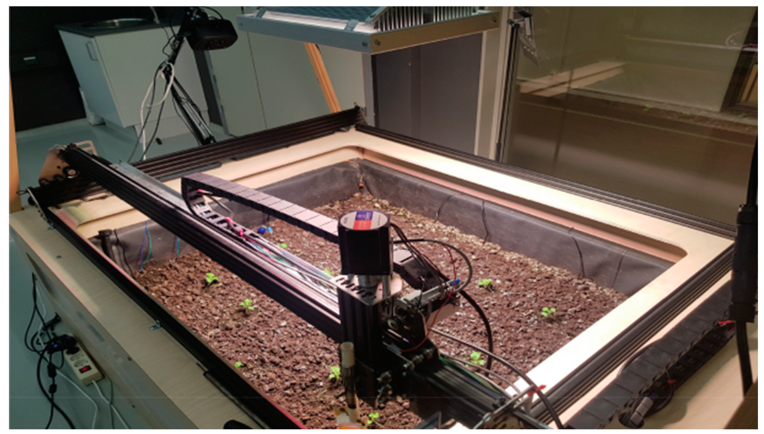
Figure 2.
Map Filter 2.0 system user interface overview (Maldaner, 2021).
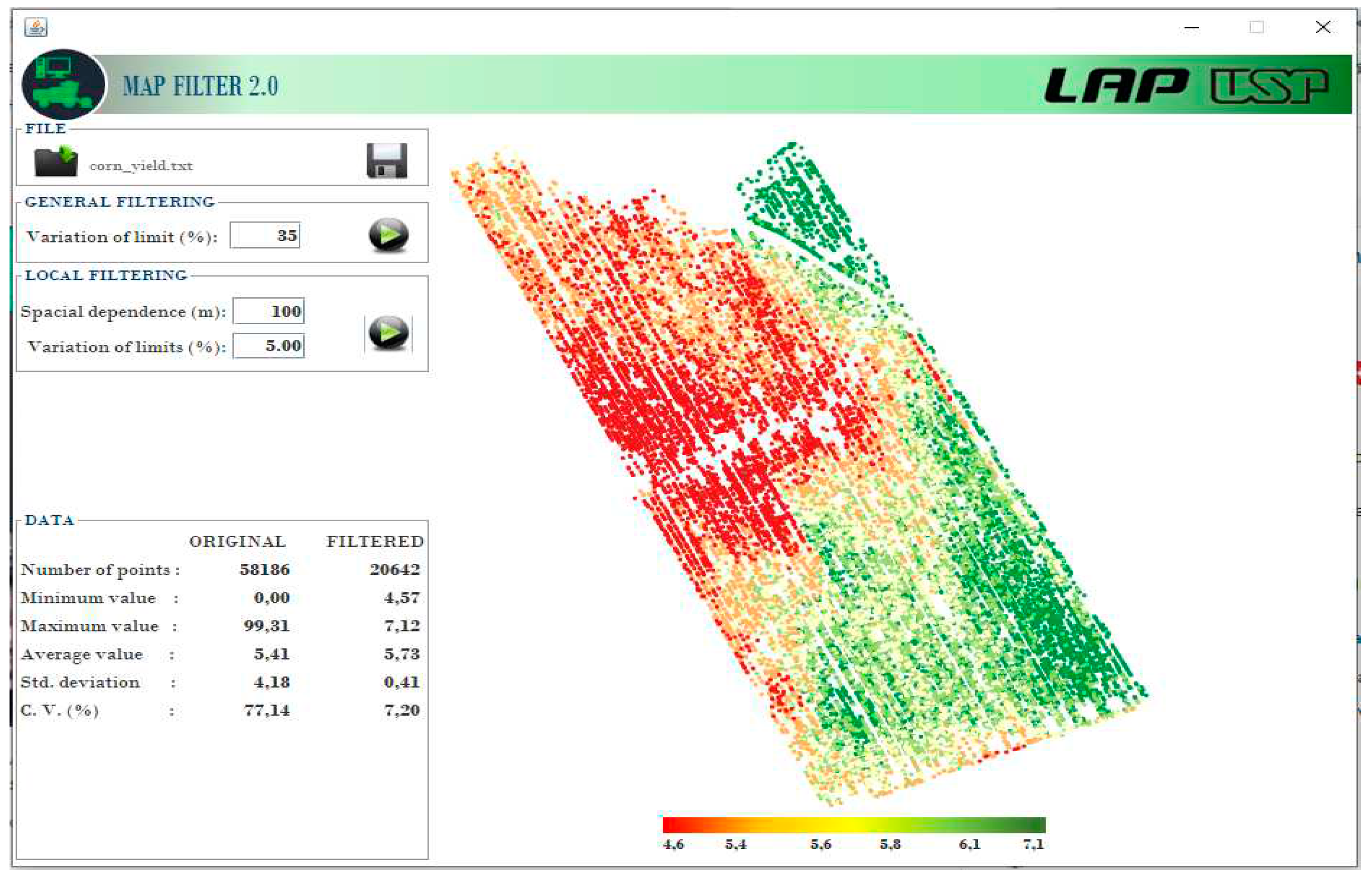
Figure 3.
Number of works published per year in the last 6 years and their trend indication using an ordinary least squares linear regression.
Figure 3.
Number of works published per year in the last 6 years and their trend indication using an ordinary least squares linear regression.
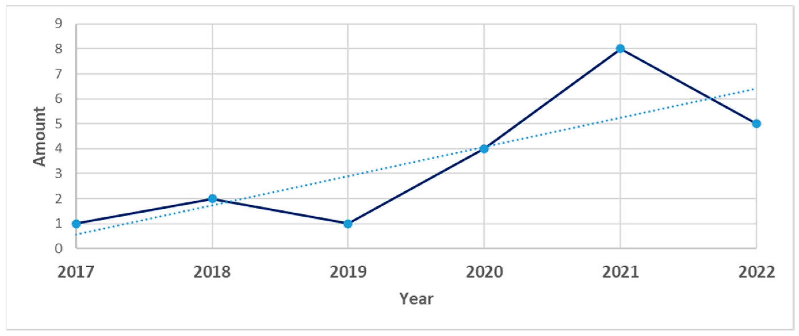
Figure 4.
Percentage of each language found in the researched works.
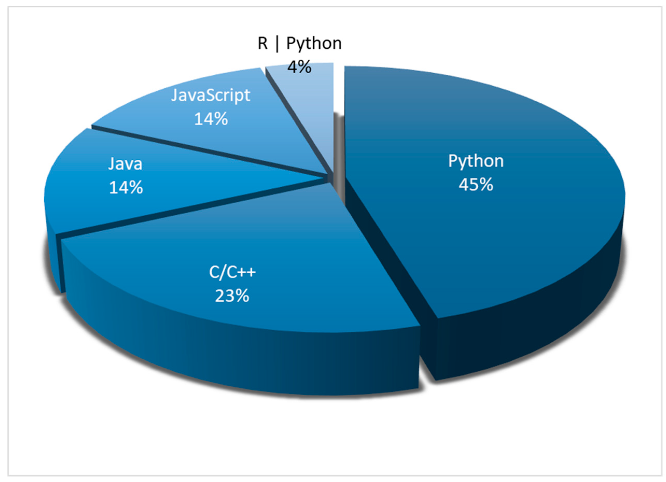
Figure 5.
Distribution of user interfaces.
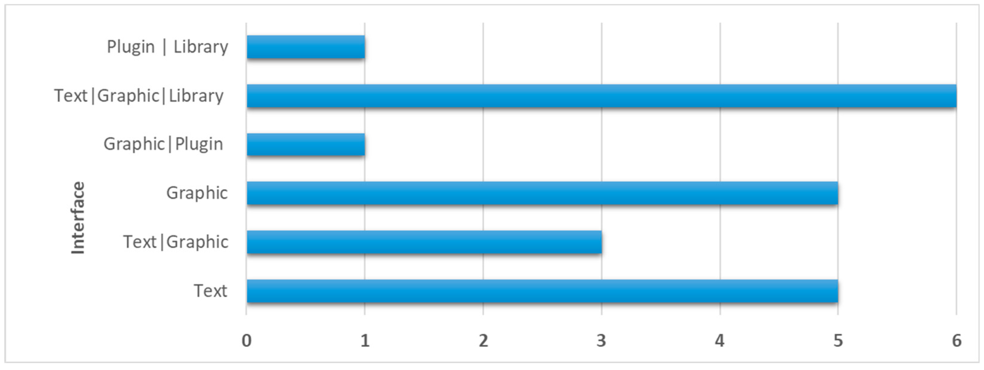
Figure 6.
Representation of works divided by categories or application area.
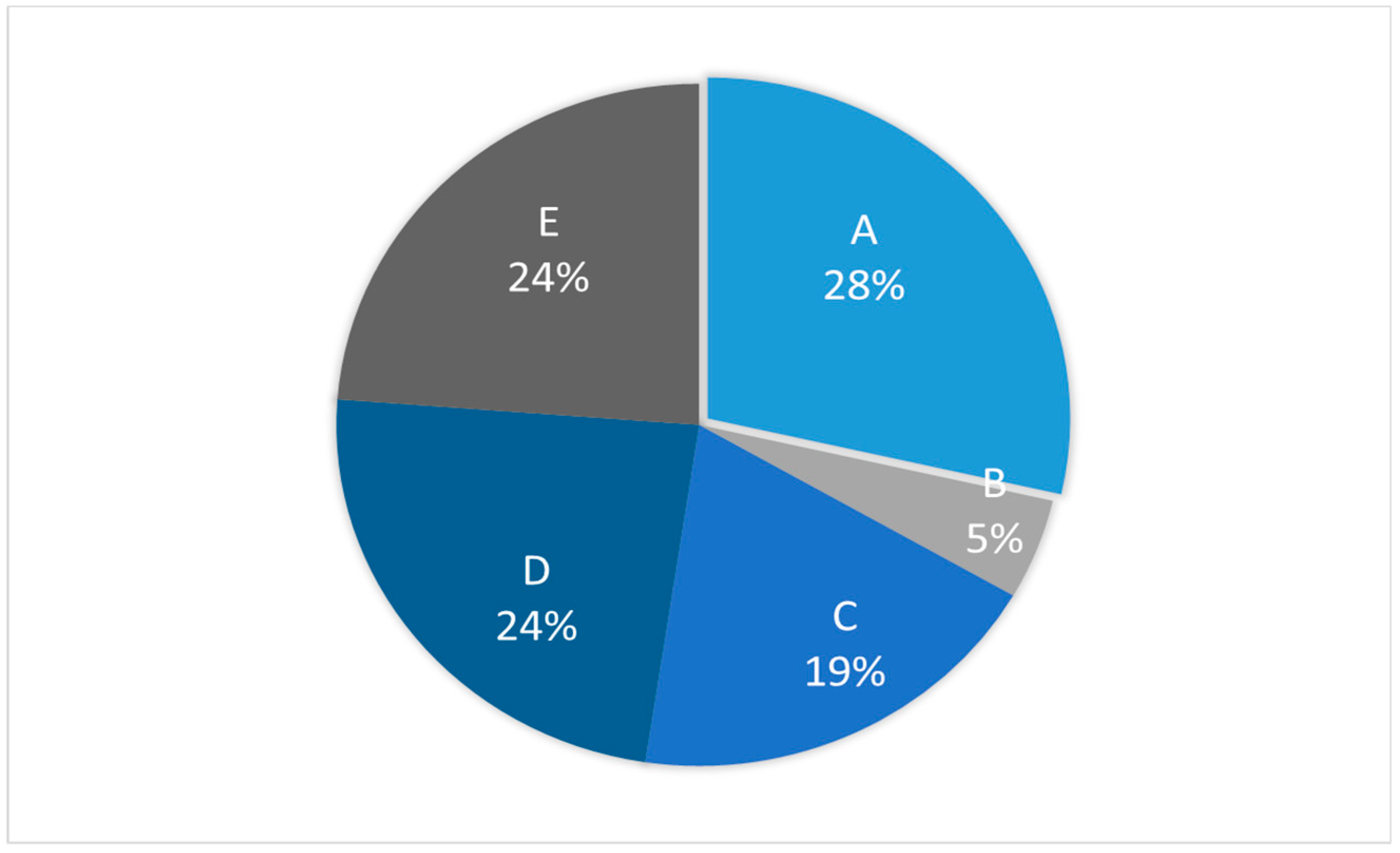

Table 1.
- Databases, search strings and the number of results found.
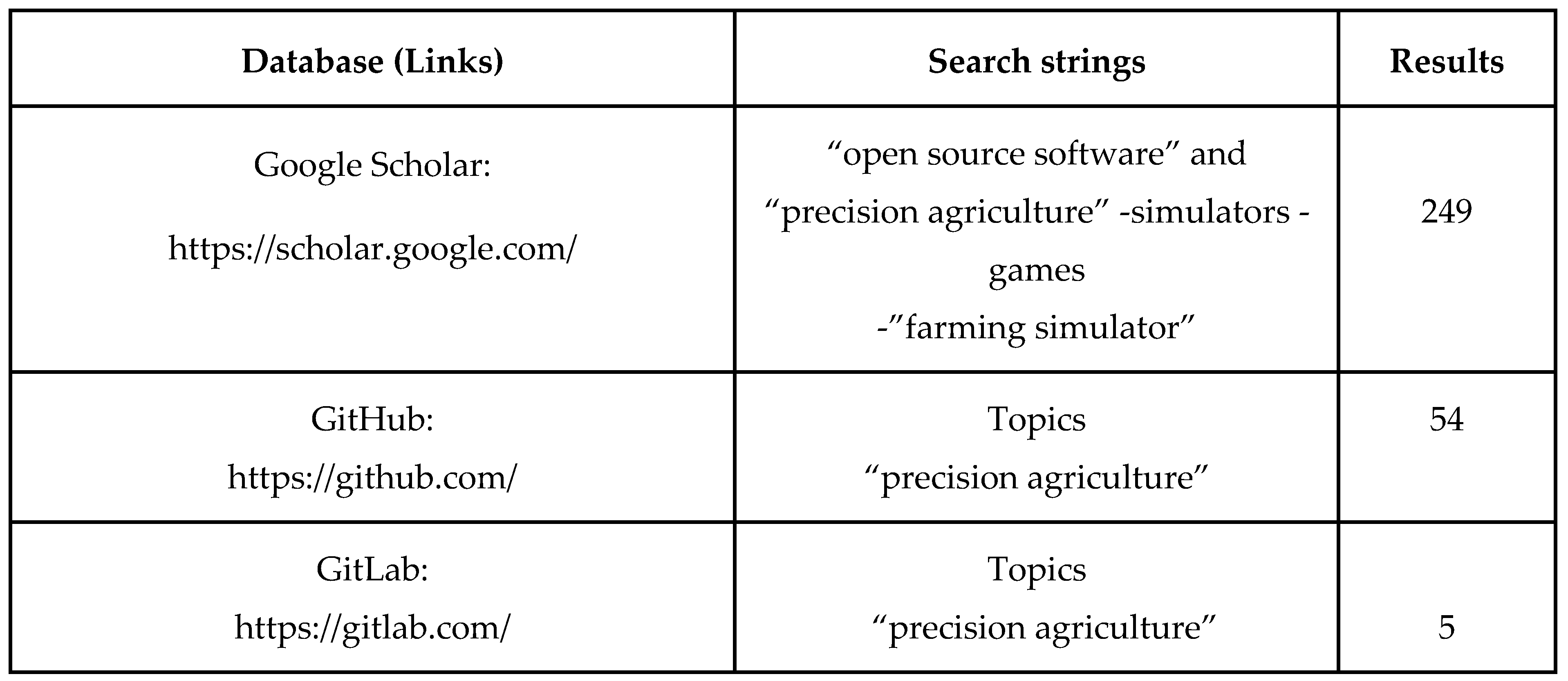 |
Table 2.
- Research of works in electronic database from the years 2012 to 2022.
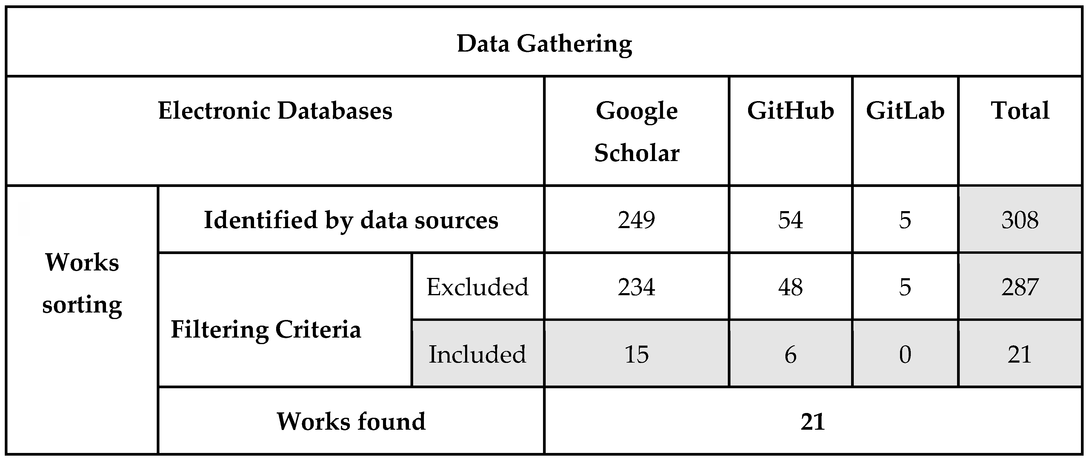 |
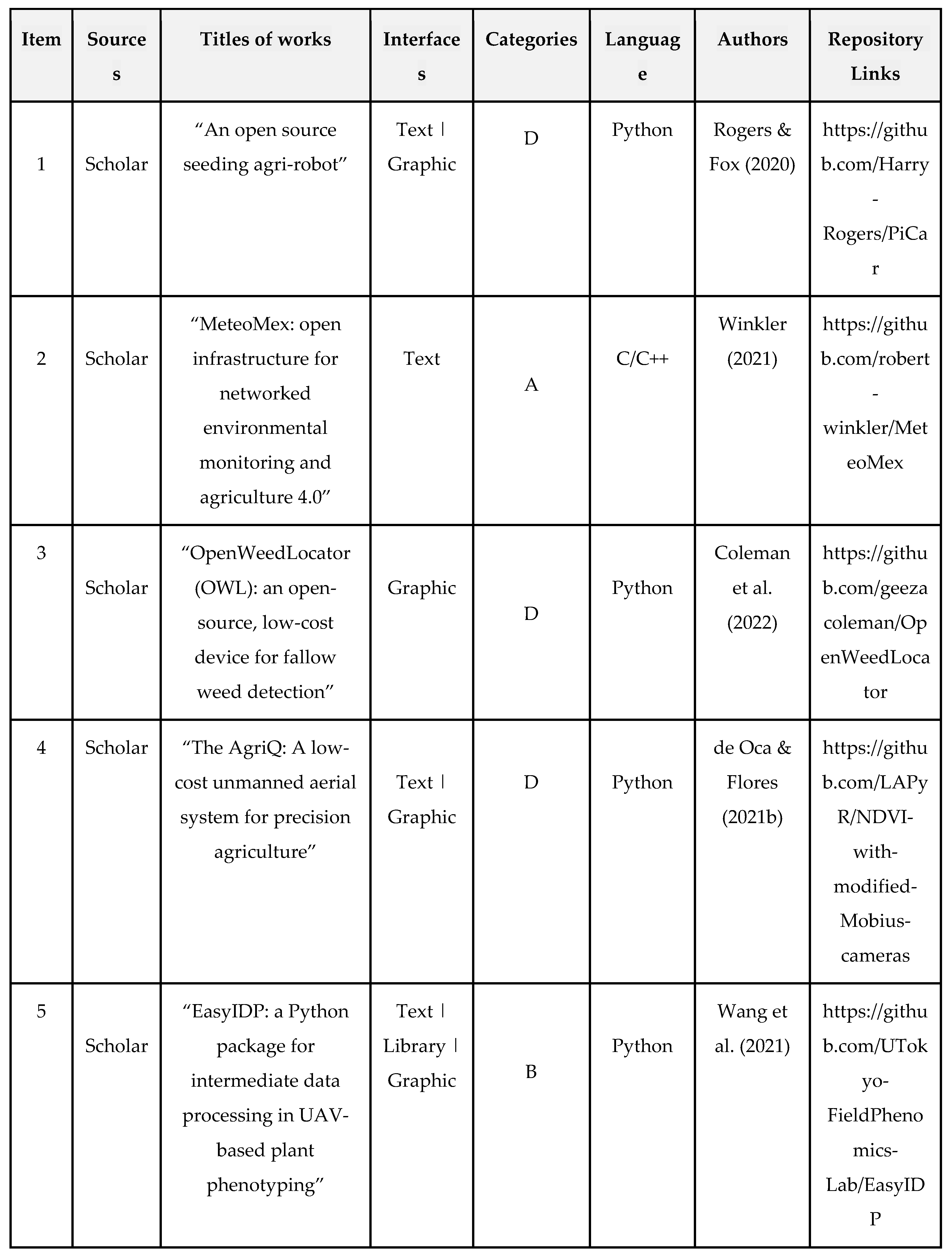
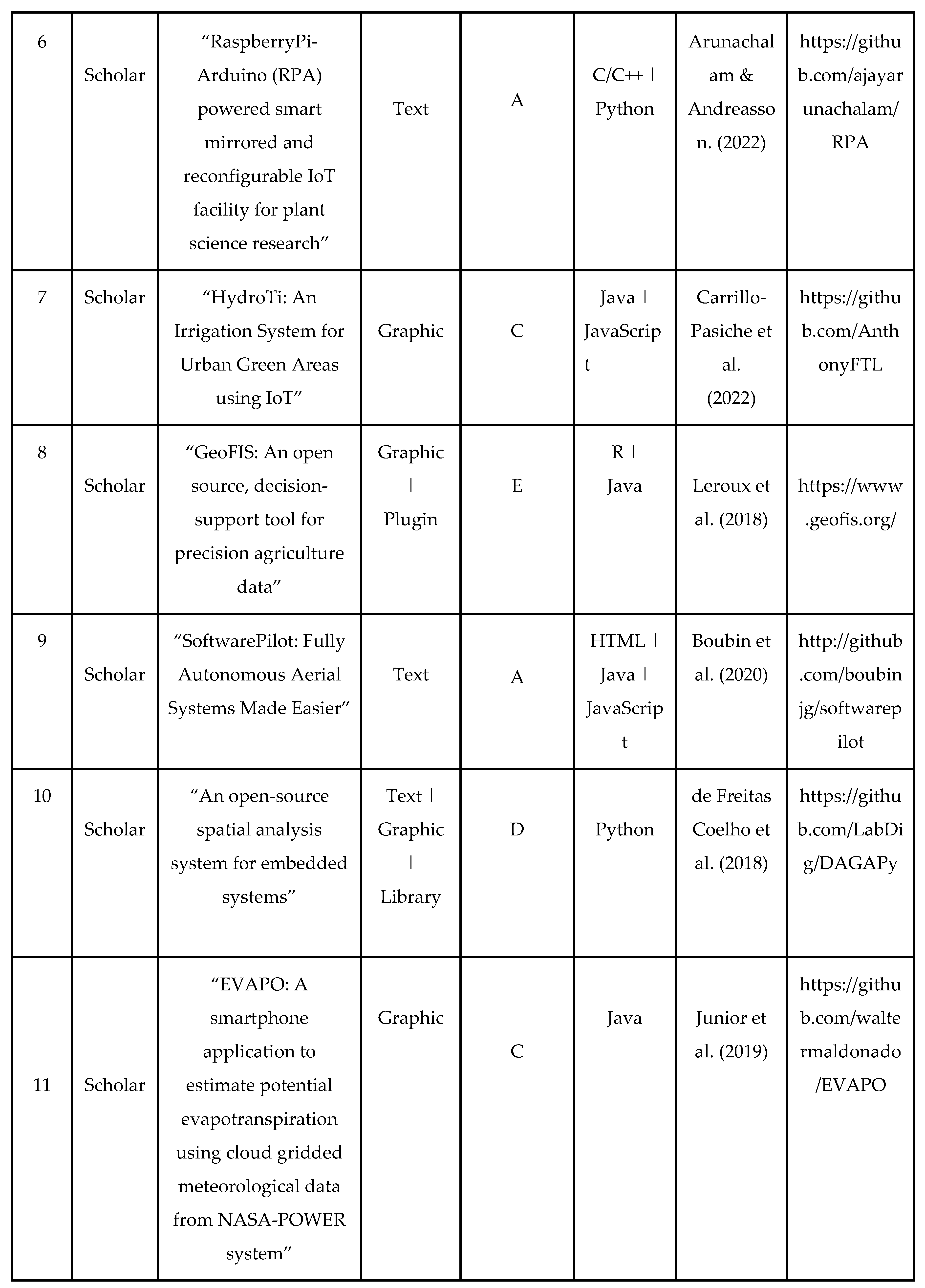
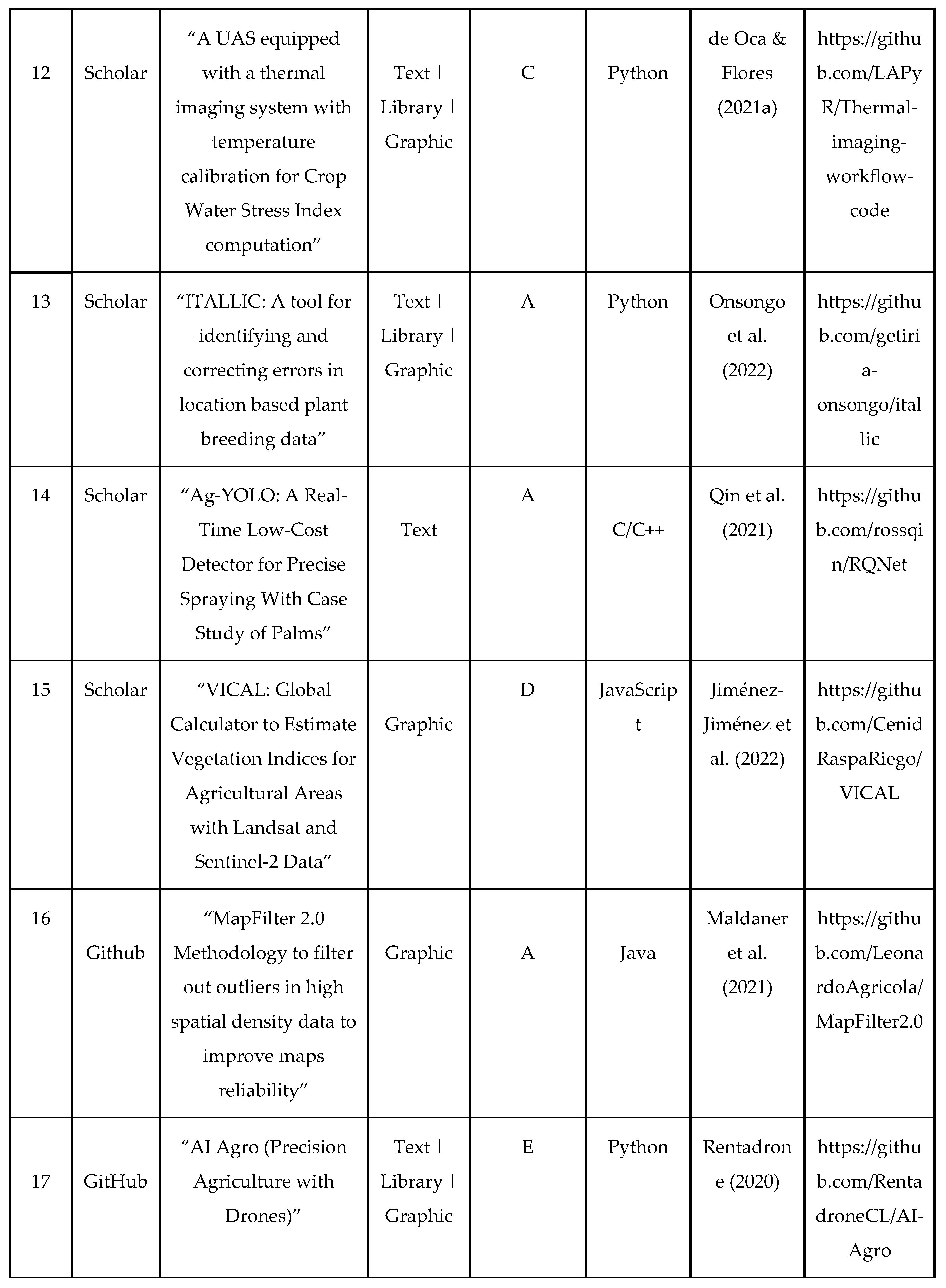
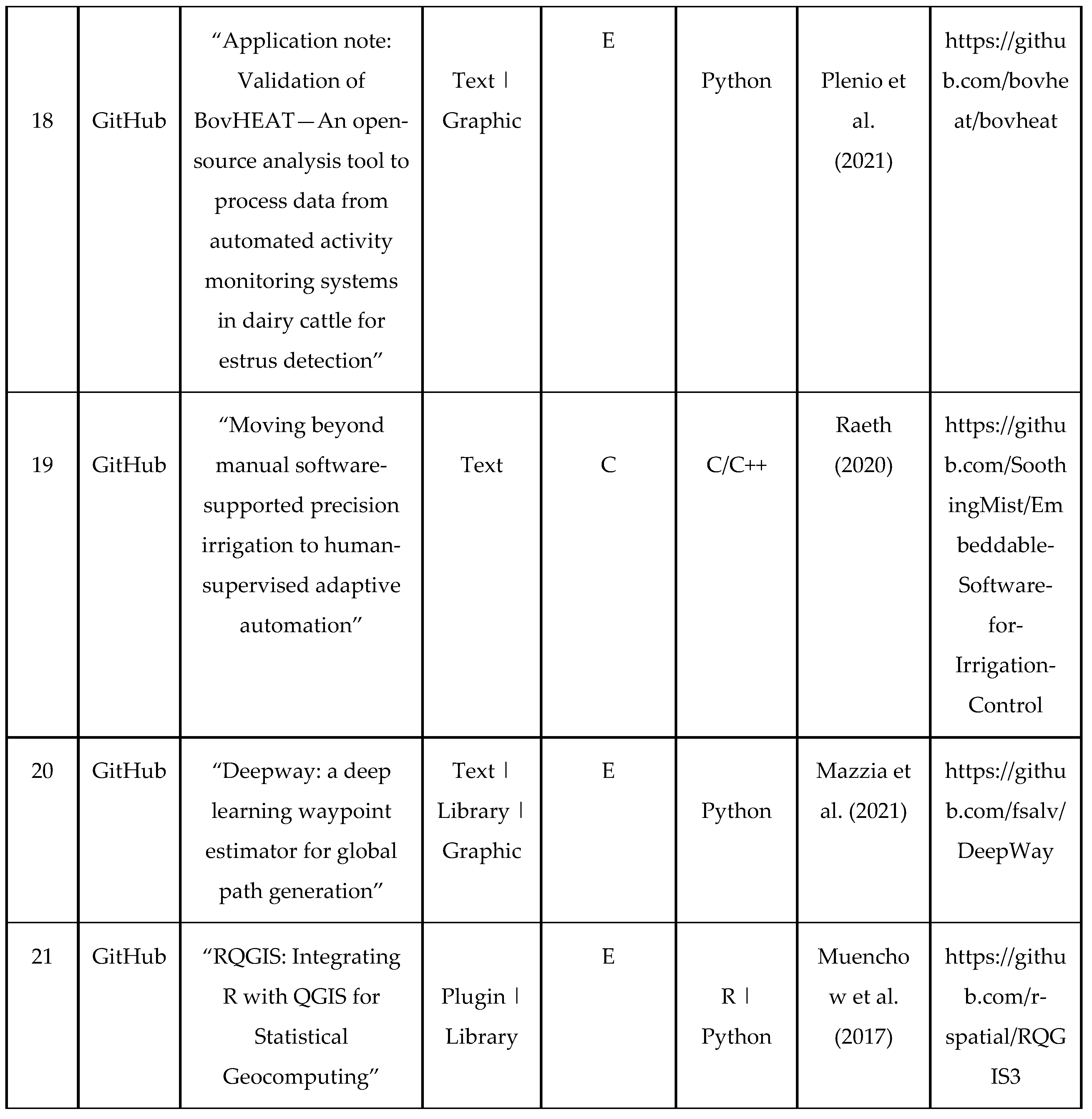
Table 3.
- Mapping of researched works.
|
Disclaimer/Publisher’s Note: The statements, opinions and data contained in all publications are solely those of the individual author(s) and contributor(s) and not of MDPI and/or the editor(s). MDPI and/or the editor(s) disclaim responsibility for any injury to people or property resulting from any ideas, methods, instructions or products referred to in the content. |
© 2023 by the authors. Licensee MDPI, Basel, Switzerland. This article is an open access article distributed under the terms and conditions of the Creative Commons Attribution (CC BY) license (http://creativecommons.org/licenses/by/4.0/).
Copyright: This open access article is published under a Creative Commons CC BY 4.0 license, which permit the free download, distribution, and reuse, provided that the author and preprint are cited in any reuse.


