Submitted:
21 April 2023
Posted:
21 April 2023
You are already at the latest version
Abstract
Keywords:
1. Introduction
2. Methodology
2.1. Determination of Ground Temperature by Numerical Approach
- Tsoil (D, tyear) = Ground Temperature
- Tmean = average surface i.e. air temperature
- Tamp = Amplitude of surface temperature [(max. air temperature – min. air temperature)/2]
- D = Depth below the surface (surface=0)
- α = Thermal diffusivity of the soil
- tyear = current time (day)
- tshift = day of the year of minimum surface temperature
2.2. Determination of Ground Temperature by Experimental Approach
3. Results
3.1. Temperature Correlation
4. Discussion and Conclusions
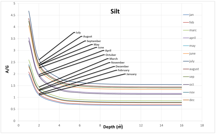
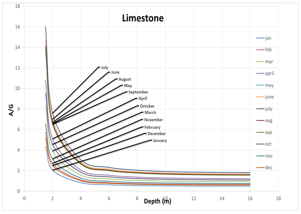
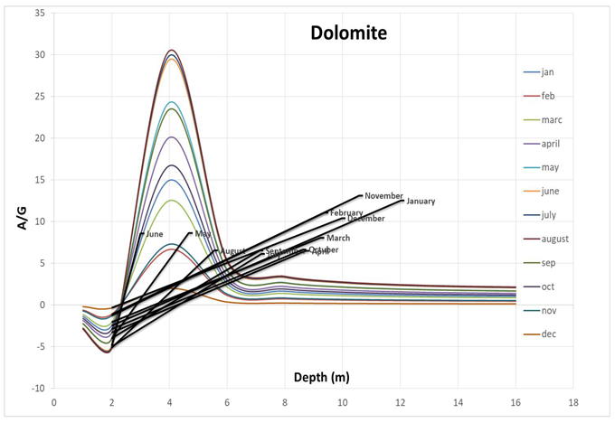
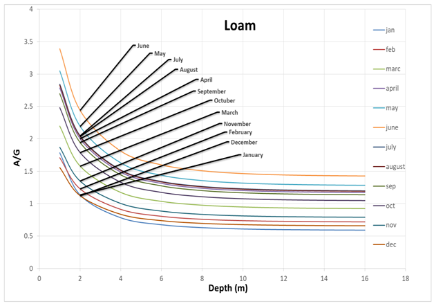
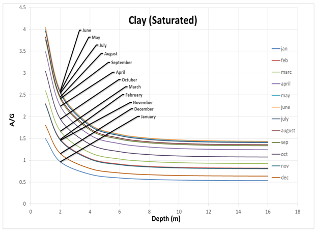
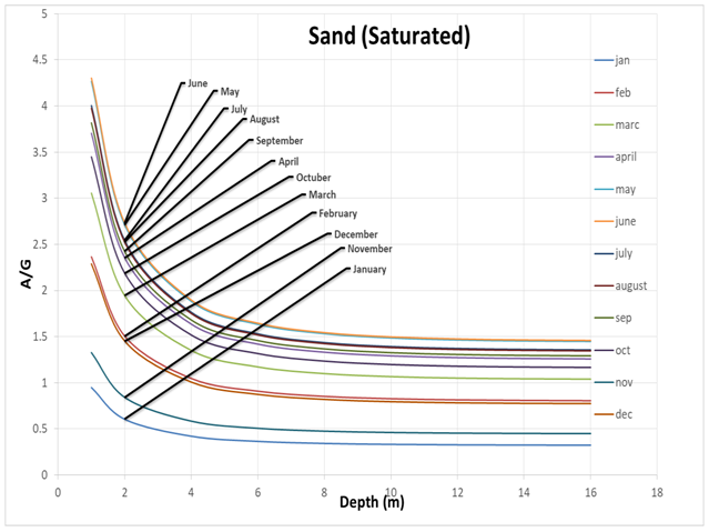
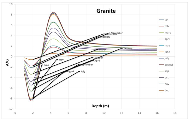
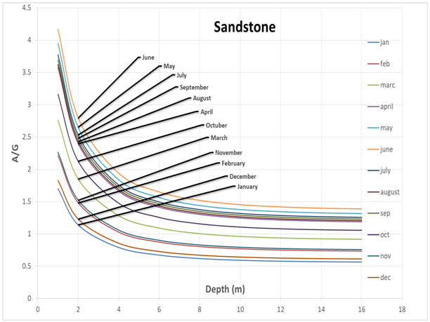
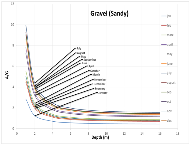
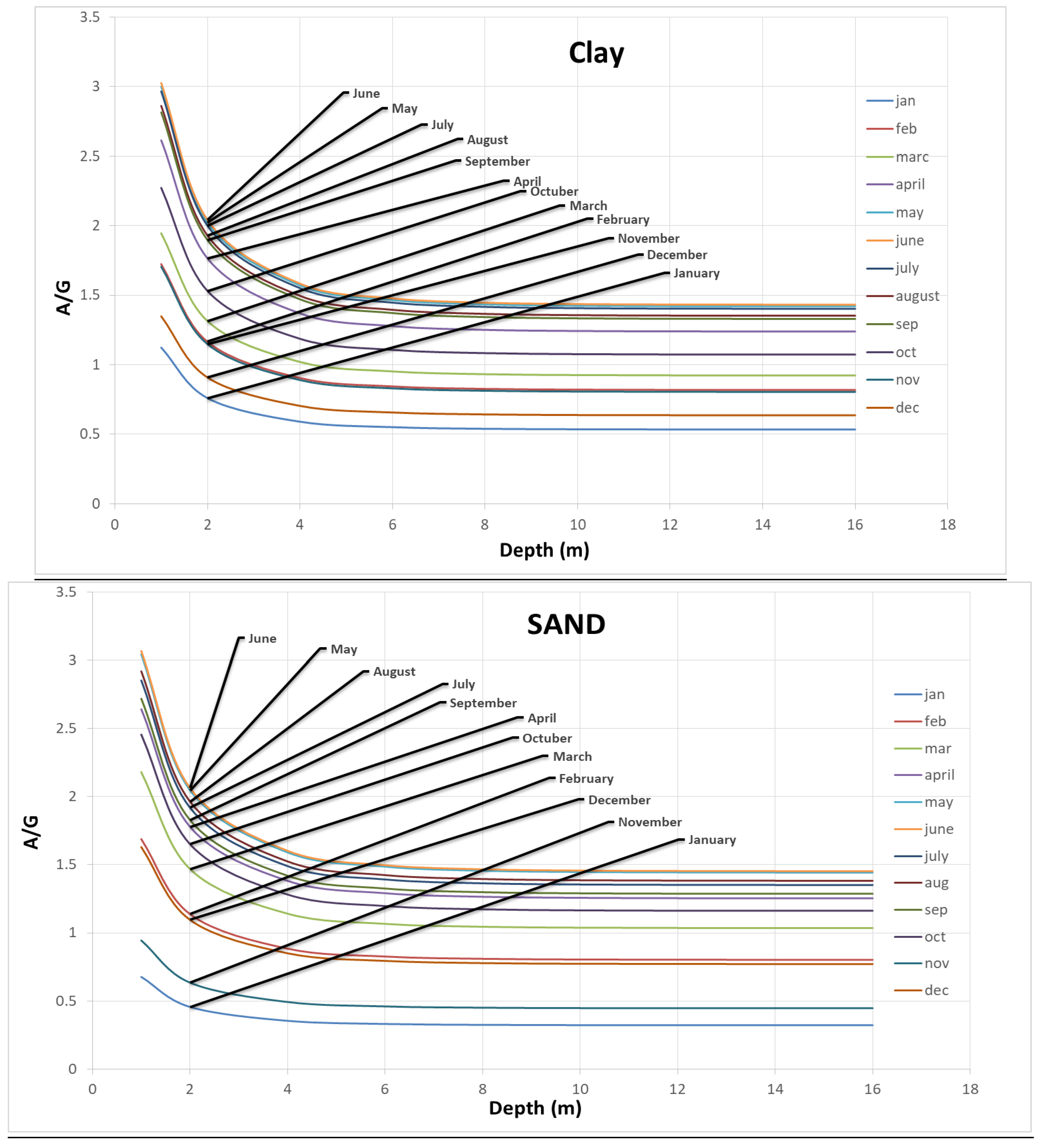
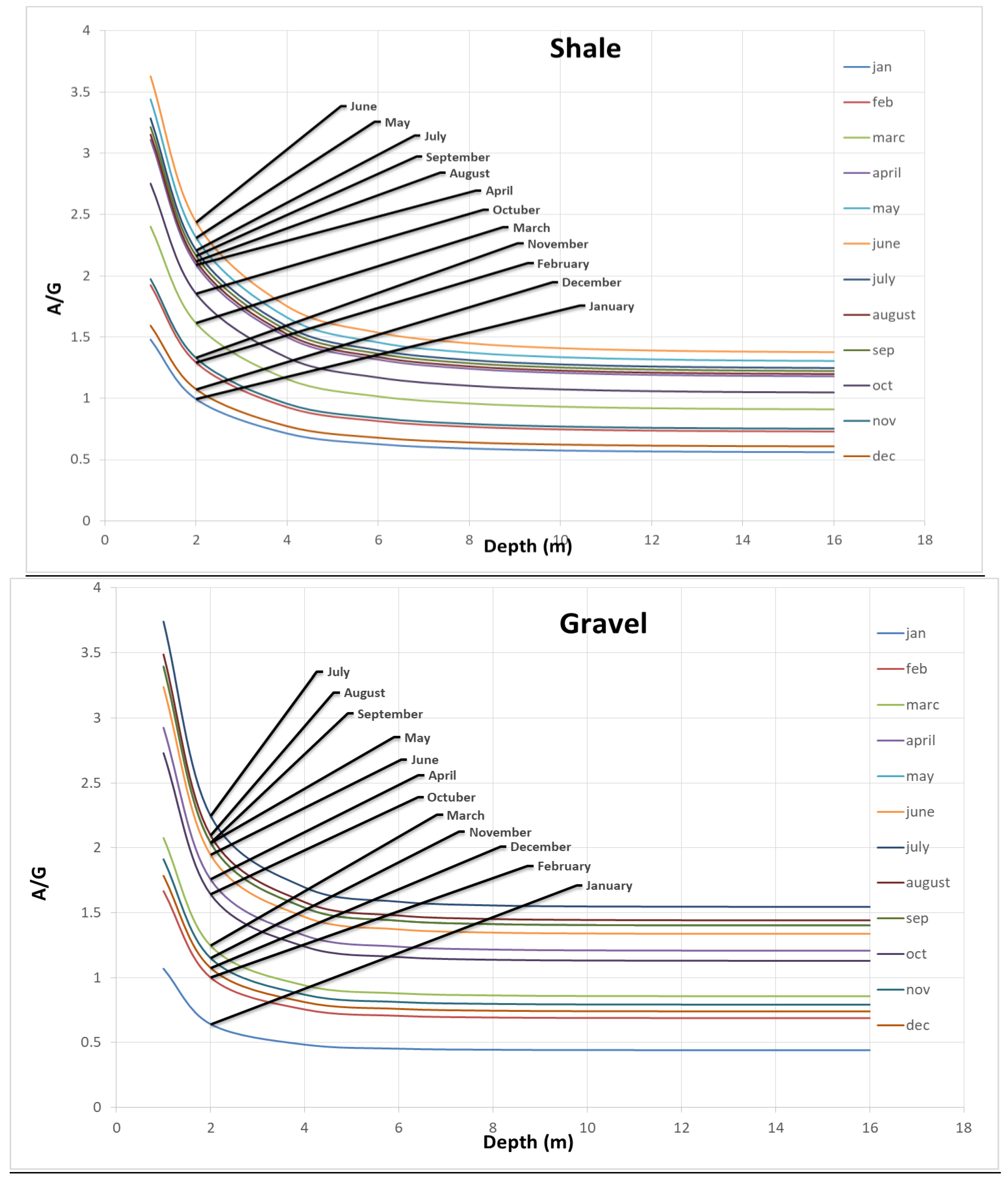
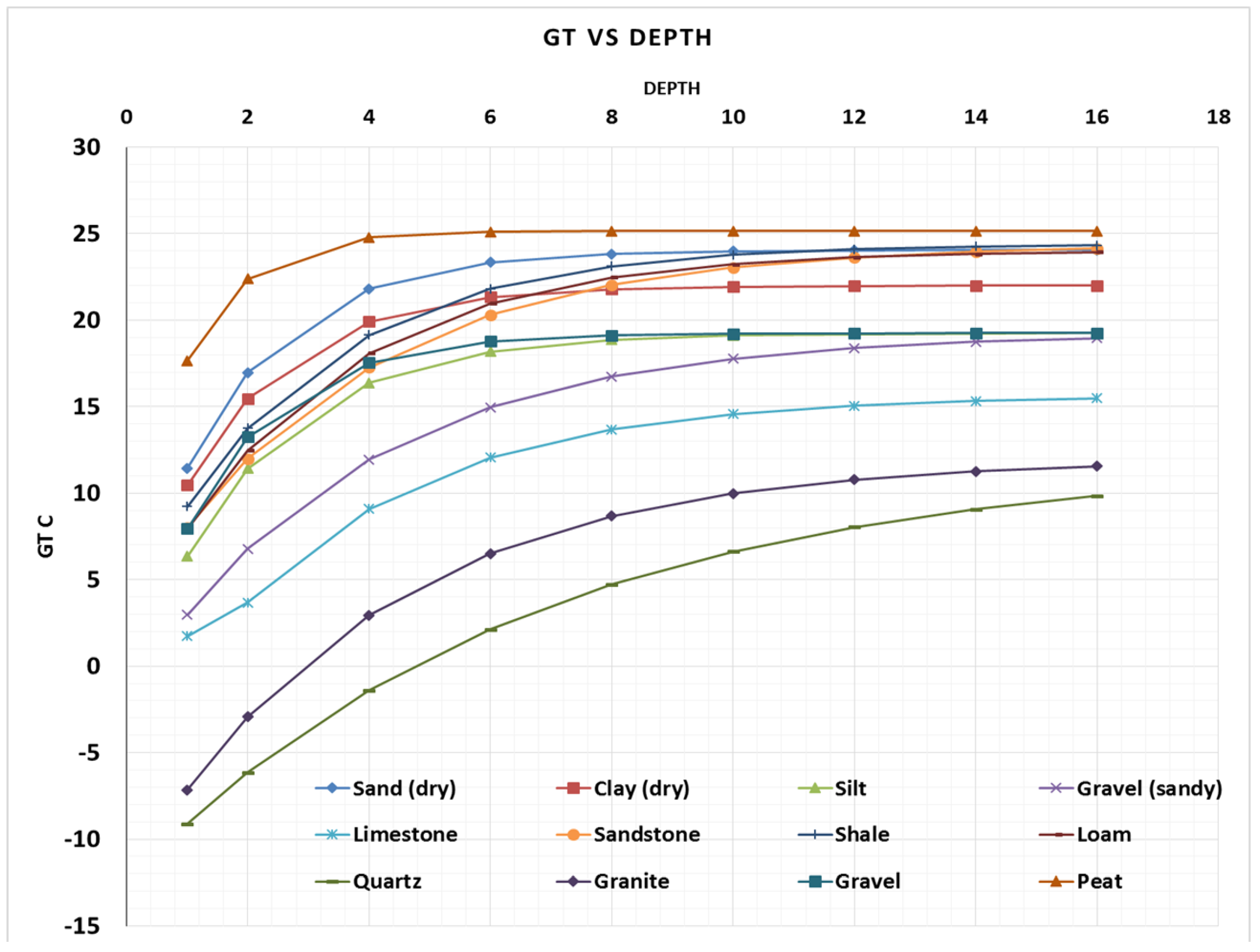
- Ground temperature charts show that type of soils/rocks and its characteristics govern the transmission of ground temperature between soil and the structural foundation element.
- Rock types at a shallow depth have a highly fluctuating A/G temperature profile as compared to the same rock types at higher depths.
- A/G ratio for igneous and sedimentary rocks (Granite and Dolomite) is higher than soil and soft rocks.
- Significant fluctuation of A/G pattern is observed in the case of Dolomite and other sedimentary rocks.
- A/G pattern is similar to that of soils observed in case of Limestone, Sandstone and Shale even though they are sedimentary rocks.
- The geothermal potential of Pakistan is easily conceptualized by using the A/G charts.
Author Contributions
Acknowledgments
Conflicts of Interest
Appendix A
 |
 |
 |
 |
 |
 |
 |
 |
 |
References
- Alcaraz M, García-Gil A, Vázquez-Suñé E, Velasco V. Use rights markets for shallow geothermal energy management. Applied Energy 2016;172:34–46. [CrossRef]
- Arshad F, Shamshad M. Energy Crisis in Pakistan: Socio-Economic Implications and the Way Forward. Annals of Social Sciences and Perspective 2022;3:105–15. [CrossRef]
- Ali M, Wazir R, Imran K, Ullah K, Janjua AK, Ulasyar A, et al. Techno-economic assessment and sustainability impact of hybrid energy systems in Gilgit-Baltistan, Pakistan. Energy Reports 2021;7:2546–62. [CrossRef]
- Kalair A, Abas N, Saleem MS, Kalair AR, Khan N. Role of energy storage systems in energy transition from fossil fuels to renewables. Energy Storage 2021;3:e135. [CrossRef]
- Kumari S. Chapter-5 Global Warming: Causes, Effects and Solutions. Emerging Trends in Agriculture Sciences 2021:67.
- Wang LK, Wang M-HS, Wang N-Y, Wong JO. Effect of Global Warming and Climate Change on Glaciers and Salmons. Integrated Natural Resources Management, Springer; 2021, p. 1–36.
- Nautiyal A, Ramlal A. Clean Energy Sources for a Better and Sustainable Environment of Future Generations. Energy: Crises, Challenges and Solutions 2021:151–68.
- Dincer I, Acar C. A review on clean energy solutions for better sustainability. International Journal of Energy Research 2015;39:585–606. [CrossRef]
- Evans A, Strezov V, Evans TJ. Assessment of sustainability indicators for renewable energy technologies. Renewable and Sustainable Energy Reviews 2009;13:1082–8. [CrossRef]
- Farooqui SZ. Prospects of renewables penetration in the energy mix of Pakistan. Renewable and Sustainable Energy Reviews 2014;29:693–700. [CrossRef]
- Khan HA, Pervaiz S. Technological review on solar PV in Pakistan: Scope, practices and recommendations for optimized system design. Renewable and Sustainable Energy Reviews 2013;23:147–54. [CrossRef]
- Farooqui SZ. Prospects of renewables penetration in the energy mix of Pakistan. Renewable and Sustainable Energy Reviews 2014;29:693–700. [CrossRef]
- Hossein S, Bukhari S. Country Update Paper on Pakistan. World Geothermal Congress 2015 2015:7.
- Ahmad M, Rafique M, Iqbal N, Fazil M. Investigation of origin, subsurface processes and reservoir temperature of geothermal springs around Koh-i-Sultan volcano, Chagai, Pakistan. Pakistan Institute of Nuclear Science and Technology; 2009.
- Bakht MS. AN OVERVIEW OF GEOTHERMAL RESOURCES OF PAKISTAN . Bakht. World Geothermal Congress, Khyushu-Tohoku, Japan, May 28-June 10 2000:77–83.
- Ahmad I, Rashid A. Study of geothermal energy resources of Pakistan for electric power generation. Energy Sources, Part A: Recovery, Utilization and Environmental Effects 2010;32:826–38. [CrossRef]
- Florides G, Kalogirou S. Measurements of Ground Temperature at Various Depths. Proceedings of the SET 2004, 3rd International Conference on Sustainable Energy Technologies 2004:1–6.
- Limberger J, Boxem T, Pluymaekers M, Bruhn D, Manzella A, Calcagno P, et al. Geothermal energy in deep aquifers: A global assessment of the resource base for direct heat utilization. Renewable and Sustainable Energy Reviews 2018;82:961–75. [CrossRef]
- Brandl H. Thermo-active ground-source structures for heating and cooling. Procedia Engineering 2013;57:9–18. [CrossRef]
- Manzella A, Bonciani R, Allansdottir A, Botteghi S, Donato A, Giamberini S, et al. Environmental and social aspects of geothermal energy in Italy. Geothermics 2018;72:232–48. [CrossRef]
- Axelsson G. Production capacity of geothermal systems. Proceedings of the Workshop for Decision Makers on the Direct Heating Use of Geothermal Resources in Asia, 2008, p. 14.
- Fridleifsson IB, Bertani R, Huenges E, Lund JW, Ragnarsson A, Rybach L. The possible role and contribution of geothermal energy to the mitigation of climate change. IPCC scoping meeting on renewable energy sources, proceedings, Luebeck, Germany, vol. 20, Citeseer; 2008, p. 59–80.
- Sowizdzal A. Geothermal energy resources in Poland–Overview of the current state of knowledge. Renewable and Sustainable Energy Reviews 2017. [CrossRef]
- Kusuda T, Archenbach P. Earth temperature and thermal diffusivity at selected stations in the United States. ASHRAE Transaction 1965;71:61–75.
- Muhammad IS, Baharun A, Ibrahim HS. INVESTIGATION OF GROUND TEMPERATURE FOR HEAT SINK APPLICATION IN KUCHING, SARAWAK, MALAYSIA. Journal of Civil Engineering 2016;7. [CrossRef]
- Florides G, Kalogirou S. Annual ground temperature measurements at various depths. 8th REHVA World Congress, Clima 2005:1–6. Proceedings of CLIMA 2005, Lausanne, Switzerland.
Disclaimer/Publisher’s Note: The statements, opinions and data contained in all publications are solely those of the individual author(s) and contributor(s) and not of MDPI and/or the editor(s). MDPI and/or the editor(s) disclaim responsibility for any injury to people or property resulting from any ideas, methods, instructions or products referred to in the content. |
© 2023 by the authors. Licensee MDPI, Basel, Switzerland. This article is an open access article distributed under the terms and conditions of the Creative Commons Attribution (CC BY) license (http://creativecommons.org/licenses/by/4.0/).


