1. Introduction
Society in general is aware of the importance of protecting and preserving cultural heritage, giving it the value, it deserves. In Europe, it is also an asset that favors the development of a digital-based economy [
1]. A way of preserving and giving access to this content, both to people and to other organisations, is to digitise museum objects. The European institutions, aware of this problem, created at the end of 2011 the recommendation to present, digitise and facilitate online access to cultural heritage data [
2]. This recommendation promotes initiatives such as Europeana Collections [
3] and it provides more of 70 million euros of financing to six programs within Horizon 2020 Societal Challenges between 2014 and 2020 with this objective.
Nowadays, there is much work to be done, NEMO (Network of European Museum organisations) published in 2020 a report that shows that European museums have only digitised 43% of their collections [
4]. However, in the last decade many projects for the digitization of cultural heritage objects have appeared, in which the information is supported by knowledge graphs [
7,
9,
10]. These works offer access to their content through web interfaces to the public in general, and through web services to external applications. In addition, given the volume of data, they often offer interactive visualisation tools to show it to their users.
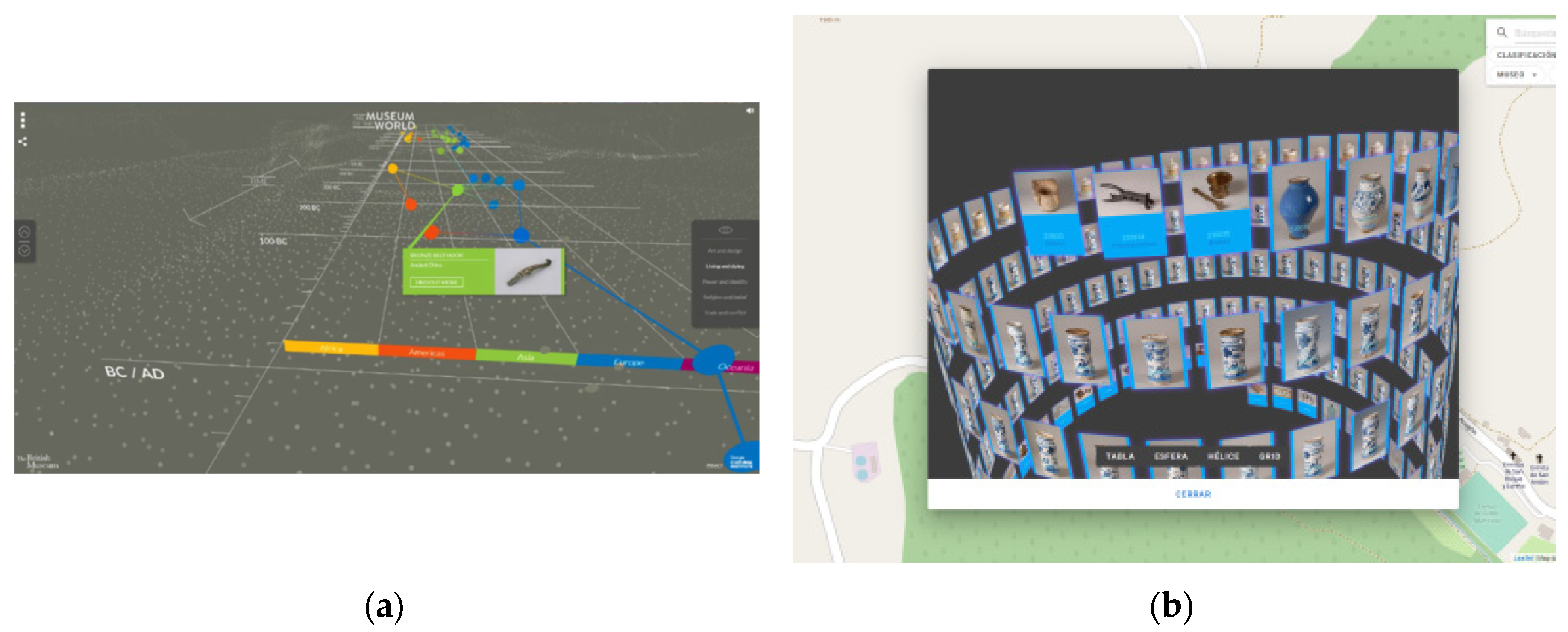
Many of these display systems use innovative interfaces to represent information and facilitate user interaction. In this type of project, the spatio-temporal representation of information is one of the main axes. Traditionally, this information has been visualized through two-dimensional maps, but systems in three dimensions [
5], two and a half dimensions [
6], and even mixed solutions [
7] are also used. Screenshots of the results of these projects are shown in
Figure 1. The solutions used to visualise the information in these works are usually highly oriented to the project objectives, and many of them are not open-source projects. This makes it difficult to reuse the system for another data domain. Additionally, cultural heritage data are associated with two characteristics on which have been little studied: uncertainty and granularity variation, both in space and time.
Uncertainty, references to the fact that in cultural heritage it is common not to know for sure where or when an object was created, who was the creator, the owner, etc. Therefore, depending on the expert who catalogs the object, various time and space intervals may appear associated with the object. In addition, such time intervals, or geographic references, in the case of space, can be quite different between different domain data. An example of these problems can be seen in the information about an ancient textile retrieved from the Terrassa Textile Museum [
8]:
Cronology: Origin: Qing Periode (1644dC-1911 dC) / XIX Century
Origin: Orient/ China/France/Holland
The difference in spatial and temporal granularity is the fact of giving the information with different reference units. In the previous example, a time interval defined by years that includes 3 centuries (1644 – 1911) is shown at the temporal level, with another that is a century (19th century). An example at the spatial level could be referencing an object in France, and another in Paris, where is an object that is in France graphically located? In the center of the country? In your capital? No solution is perfect, but the worst thing is that in the examined works, the object is represented in a spatial location and with temporal information, without informing the user, unless she/he requests more data, that there are more locations and that the one represented does not have to be true.
Another aspect that is not usually represented, or is done with great limitations, is the relationship between the represented objects. Sometimes the objects represented can use the same materials, apply a specific technique, have the same authorship, etc. This similarity is not usually represented graphically and only some projects, such as Semap, which shows textual information, or Jewish Culture, which joins them with lines, show these relationships. This information is essential to detect patterns and compare the information resulting from the same query.
In most of the projects studied, the visualisation tools allow the application of temporary filters, by century, year, etc., but they do not allow the simultaneous viewing of the query data at different moments in time. This tool, like the relationships, makes it possible to graphically compare the information broken down at different moments in time and thus be able to analyze the temporal evolution of the data.
This paper starts with the reasoning that many problems could be solved, or at least reduced, if the visualisation of the information was formalized through a model, implemented with an ontology, and the execution of a software tool capable of representing the information processing the content the ontology. Logically, the model must contemplate different visualisation scenarios, be capable of adapting to any domain of cultural heritage data, in addition to contemplating various possibilities to solve the problems. In this way, the resulting visualisation system could be adapted to any data model and change the way information is visualized only by adequately defining the instances of the ontology.
Next, previous research is presented to formalize and visualise the content of knowledge graphs through an ontology. Then, based on these works, as well as the study of data visualisation systems, and taking into account the previously mentioned characteristics and problems, a cultural heritage data visualisation model is detailed. In addition, the implementation of an ontology that represents said exposed model is described, as well as a software architecture that allows representing the content of a knowledge graph by processing the content of this ontology.
Finally, the application of this tool is shown in two projects with cultural heritage data supported by a knowledge graph, such as SILKNOW [
9] and Arxiu Valencià del Disseny [
10], ending the document with the conclusions and the following objectives to be achieved.
2. Previous work
The first studies and developments [
11], were aimed at representing a 3D scene through an ontology. The problem with these works is that they were intricately linked to APIs such as Java 3D, and these kinds of ontologies were scene representation formats. That is, they were not designed to represent information from a knowledge graph, they were designed for an application to process the ontology with the scene information, following the structure and philosophy of visualisation technology and representing it.
Other more advanced works, such as the VISO and VUMO visualisation ontologies, do not have these problems.
The VISO ontology [
12] is really a set of ontologies designed to define how to visualise the content of a knowledge graph. These ontologies, especially the GRAPHIC ontology, define low-level and high-level graphic structures, to formalize the scene graphic representation. However, although at elevated levels of abstraction, most of the concepts are valid, when studying intermediate or lower levels of abstraction, it is observed that these are defined for the representation of two-dimensional scenes. This would imply the need to extend the ontology to contemplate the visualisation of three-dimensional scenes. This is not a major problem, but it is a task to be reckoned with.
VISO, in addition to the definition of graphic concepts, data to be handled, and other concepts of factors that influence the visualisation process, part of the visualisation definition is performed through the RDFS/OWL Visualisation Language (RVL) [
13]. This language oversees defining many aspects of the visualisation, and it is based on OWL schemas with connections to SPIN, which is incorporated into the concepts and properties of the domain ontology. Due to this, it is necessary to extend the domain ontology, and include in them RVL, from which reference is made to the VISO concepts.
A priori, this philosophy fits the objectives of this research, but there are a series of important problems:
The RVL language is complex, and with a low-level of readability, it requires a significant cost of learning. This implies the need for experts in this language to define any visualisation system. - The philosophy of this work is oriented to take as a base the graph to be visualized, the VISO ontology, and the RVL language, so that, with all this information, the scene through the display. This framework may be acceptable for visualizations of medium or basic complexity. However, if the goal is to implement a visualisation system with advanced interfaces, or complex scenes, RVL scripts would be large, costly to develop, and difficult to maintain. In addition, it does not offer the possibility to connect with other applications through an API, and it does not present user interface options.
The RVL viewer requires a lot of work to be able to represent many elements of a scene of basic complexity.
VUMO [
14] is an ontology designed to visualise urban mobility data. Due to this, it has an ontology composed of elements used in these systems, which can be mapped with a domain ontology. With the domain ontology mapped, it offers a recommendation system, which populates a visualisation ontology, in which there are 2 types of scenes defined, Geographic Heat Map and Calendar Heat Map. VUMO includes a series of graphic concepts, not as complex as the VISO ontology, but which allow the definition of most of the graphic primitives, and thus customize some aspects of the visualisation of the scenes to be represented.
The work done with VUMO is very well designed, but has several problems to fully use it for the purposes of this document:
It is a system designed to visualise elements of urban mobility. A priori, it does not have much in common with cultural heritage, and there are characteristics, such as uncertainty, or granularity, not contemplated. But deep down, they are still elements located in space, whose position and characteristics can vary over time. This means that it could be used to represent some cultural heritage display systems, but extensions would have to be made to account for granularity, uncertainty, and overtime. At a temporal level, the main difference is that VUMO is very orientated to real time, minutes and seconds are particularly important in urban traffic issues, but these data are never considered cultural heritage. In addition, there would be several concepts that would never be used. - The graphic customization capabilities are extremely limited and it does not contemplate the use of three-dimensional elements.
No VUMO viewer has been developed.
After analyzing these works, it is ruled out to apply it directly for the research’s objectives. However, there are a number of items that are very interesting and must be considered for the design of the model and the implementation of the ontology that represents it:
Map the concepts of the knowledge graph to be represented, with those of a visualisation ontology. This idea is applied in VUMO and VISO.
The idea applied in VUMO of delegating to an external system the task of visualizing the ontology information through scene types.
VISO has developed the GRAPHICS ontology that represents different graphic possibilities with a high-level of depth.
3. Visualization model
This section describes a representation model for cultural heritage data visualisation systems. Its content is based on the analysis of several works related to visualisation systems [
15,
16], analyzing the problems related to the field of cultural heritage, as well as reviewing the state of the art in the formalization of visualisation. This model is based on two main concepts:
-
Visual objects: Graphic objects that can be recognized visually, these elements are related to a scenario, or visual scene on which they are represented. Visual objects in turn extend into 2 sub concepts:
o Visual element, which refers to the data to be represented, an instance or group of instances of a concept of the knowledge graph with the information.
o Scene, which represents the global visual content to be rendered. This concept contains some properties that define it but also relationships with all visual elements represented in it.
Interaction processes: Actions that are allowed to be performed in the scene, either to facilitate interaction with the user, as with other applications, or representation system events. These processes imply consequences in the representation of the scene.
2.1. Visual Elements
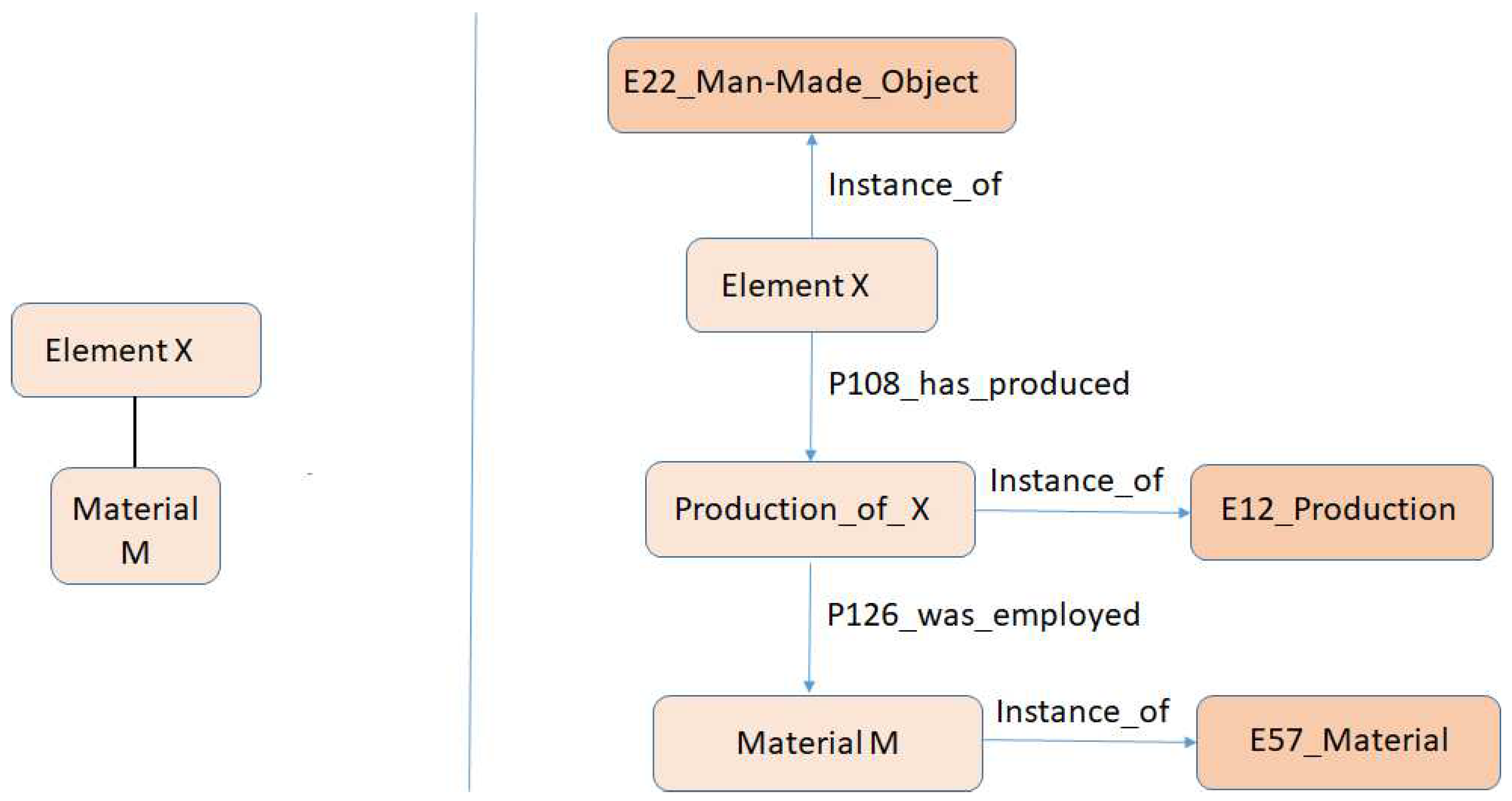
A Visual Element is a concept of the visualisation model that corresponds to a concept of the data domain. The visual element will be made up of Visual Properties, which correspond to attributes or relationships of the concept, accessible directly or through queries.
Figure 2 shows an example of the conceptualization of a Visual Element (X) and a Visual Property (M), which refers to the material of the object.
If the data domain is based on the CIDOC-CRM model [
17], one of the most used in cultural heritage, to obtain the value of the M property, a query would have to be made in each instance. In this example, using SPARQL and where <Element_URI> is the URI of the instance of the data domain concept represented by the Visual Element, the query would be as follows:
SELECT distinct ?materialLabel
WHERE {
?s
rdf:type
?s
Element_URI.
?s
?q .
?q
?materialLabel
}
Given the importance of space and time in this model, the existence of a Visual Spatial Property and a Visual Temporal Property, which extend Visual Property, will be mandatory to refer to the spatio-temporal data of the object.
A Visual Element, in addition to its properties, is related to a Marker, which references the graphic representation of the Element. This representation will be subject to the properties of the scene. For example, if the scene is three-dimensional, it will be a three-dimensional model, if it is two-dimensional, it will be a polygon with an image and/or certain colors, which can have a default value, or be modified depending on the values of the element’s properties. In addition, must be considered the graphic properties of the Marker, such as materials, or transparency.
2.2. Scene
The scene defines the representation of the information at a global level. This implies that the spatial and temporal reference system must be defined in it, as well as navigation, as well as other optional elements such as levels of detail, groupings of objects, the possibility of filtering the data, as well as visualizing relationships between objects, temporal selection and managing uncertainty. These properties are detailed below.
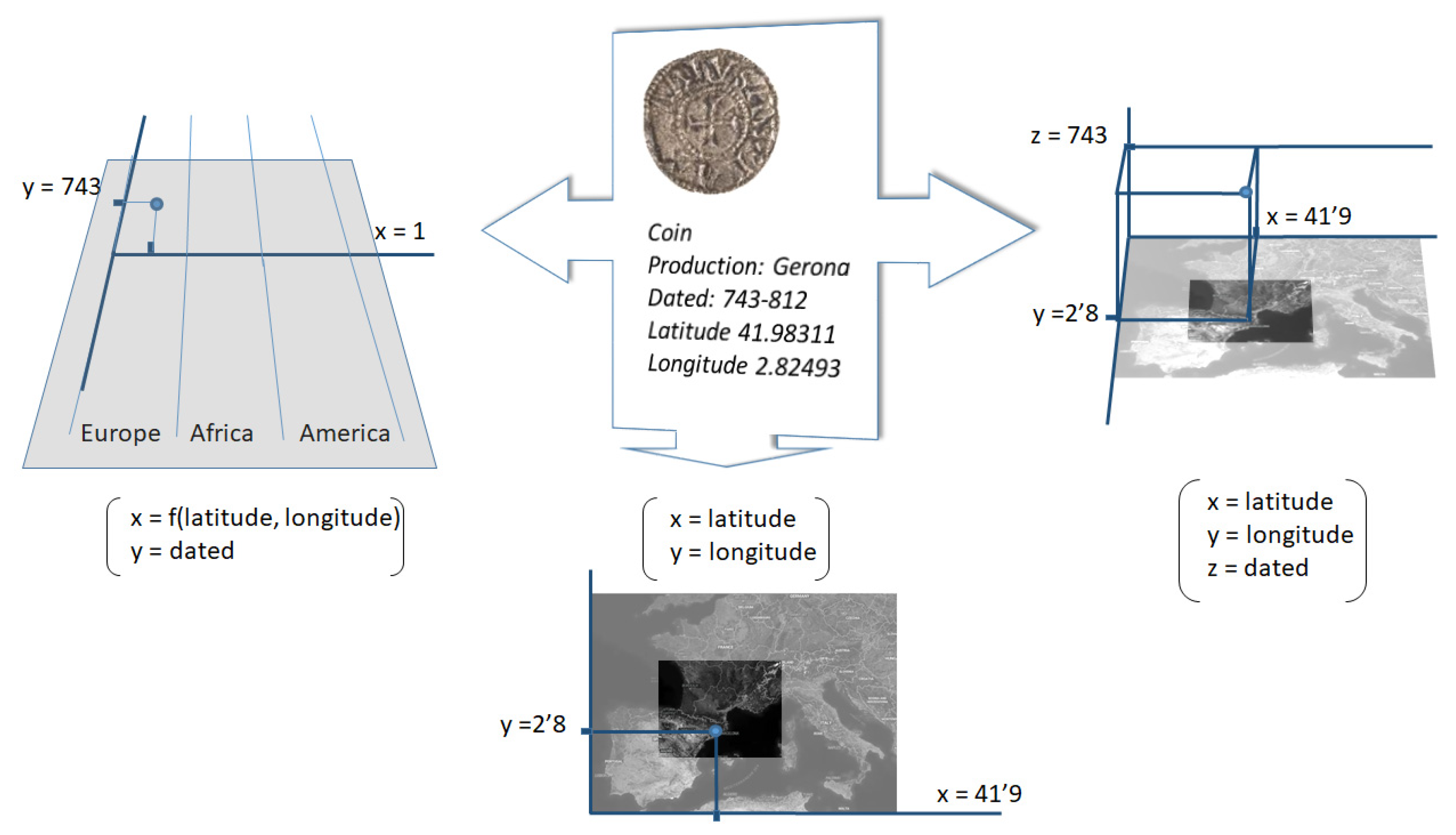
Reference systems. The temporal and spatial reference systems are necessary both in the scene and in the objects of the data domain to be represented. Additionally, the model must allow specifying how to convert the spatio-temporal coordinates of the objects in the data domain to those in the scene.
Figure 3 shows a scheme with this concept. For example, a coin that was found in a place defined by its longitude and latitude coordinates must be able to be transformed into the scene coordinate system, which can be two-, two and a half, or three-dimensional.
Navigation. User navigation is an important element, which may be limited by the type of scene. In any case, it is necessary to define whether the user will be able to zoom (approach a point in the scene), panning (move on a plane), rotate (on an axis perpendicular to the plane of vision), as well as movement. to specific areas of the scene by pressing controls.
Detail level. Additionally, the scene must be able to contemplate the possibility of having various levels of detail. This will imply that, depending on the proximity of the user’s camera to a point in the scene, its representation may change to improve its visualisation.
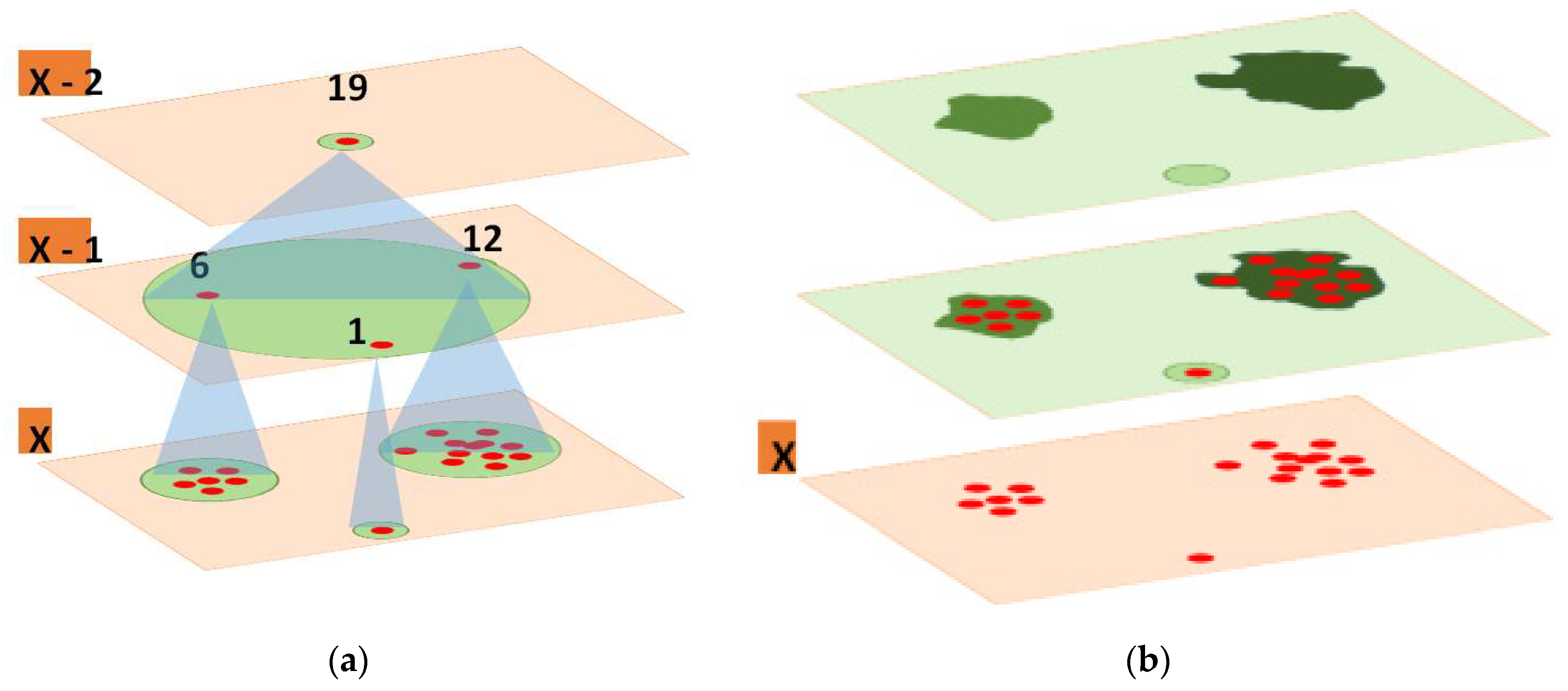
Grouping of objects. It is usual for the number of objects in a knowledge graph to have several thousand data points. This implies that data grouping techniques must be used to understand the visualisation, otherwise the visualisation scene would be populated by a multitude of Markers, which would be like superimposed point clouds. Although there are more forms of grouping, the most common, and those initially defined are:
Grouping around a representative Marker. It consists of grouping the different objects of a region, to eliminate them from the scene and replace them with a representative Marker, which is usually located in the center of the region defined by the group. This process is repeated at all levels of detail, so that at a maximum level X, the representative Markers and groups are formed from objects of the data set, but at a level X-1, with less detail. , both the markers and the groups are defined starting from the representative Markers of level X.
Heat maps. The data pools are created, in an analogous way to the previous one. Scene regions are associated with each group, or groups, based on their density. Each area is assigned a color, which is usually more intense depending on the number of data it contains, or even change color, depending on the amount of data. This form of grouping is static. Once the regions are defined and colored, they are not modified, even if you navigate to a different level of detail.
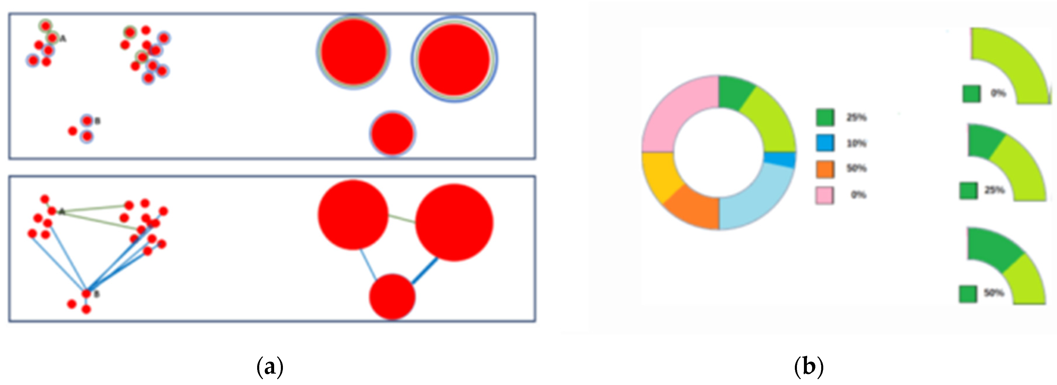
Figure 4 shows a schematic that represents the 2 forms of object grouping referenced in the display model.
Data filtering. A visualisation system, especially when is managed a large dataset, often offers filtering data. This allows better visualisation of information with certain qualities, in addition to improving the performance of the system at a graphical level, since there is less data to represent. However, it also forces you to develop user interfaces and updates the scene globally, modifying groupings, relationships, etc., as the data set in the scene is changed. The filtering system has three options to present the possible values on which to filter:
The values are previously defined, at the property level.
The values are obtained from the dataset to display. The user may select one of the different values of the property in the dataset.
No initial values. The user may enter the value to filter the data manually.
Relations. In addition to the spatial and temporal location, it may also be interesting for the user to know which objects are related to others based on other properties and visualise this relationship in some way. The most used techniques to show relationships between the data of a data system visualisation, are the following:
Mark related objects with a color or characteristic graphic Marker.
Join the objects related to each other by lines, or arcs, whose thickness, or color intensity, can vary depending on the number of data related, in the event they are groupings.
These techniques, represented schematically in
Figure 5, are acceptable if the data set is small. If they are multiple, it can be expensive to identify the related objects. This difficulty grows if several types of relationships are displayed, since an object can be related to several at the same time, which would imply using several Markers. The same is true if there are related objects outside of the display scene.
To solve this problem, a ring structure is proposed, which would ideally be placed around the object, or as close as possible. This structure would be divided into as many zones as the object’s relatable properties. Each area would be filled with a light color, and depending on the percentage of objects, the area would be filled with the same percentage of the fill color, but in its dark version.
Figure 5 shows a scheme with this graphic proposal.
Temporary selection. In the case of those scenes where time is not part of the graphic representation, if the visualisation is simultaneous, it is affected and in a complex way. In this case, a special navigation mode is entered, where the user usually has less interaction, and will follow one of the following patterns:
A two-dimensional display, which allows viewing the fluctuation of time as if it were a video, where each item on the timeline corresponds to a frame.
A three-dimensional visualisation, which uses a hypercube. The user visualizes the data at each moment of the time scale. The hypercube can be simple, where the data is displayed continuously, or include section, or slices, where only the data for each section is displayed on them.
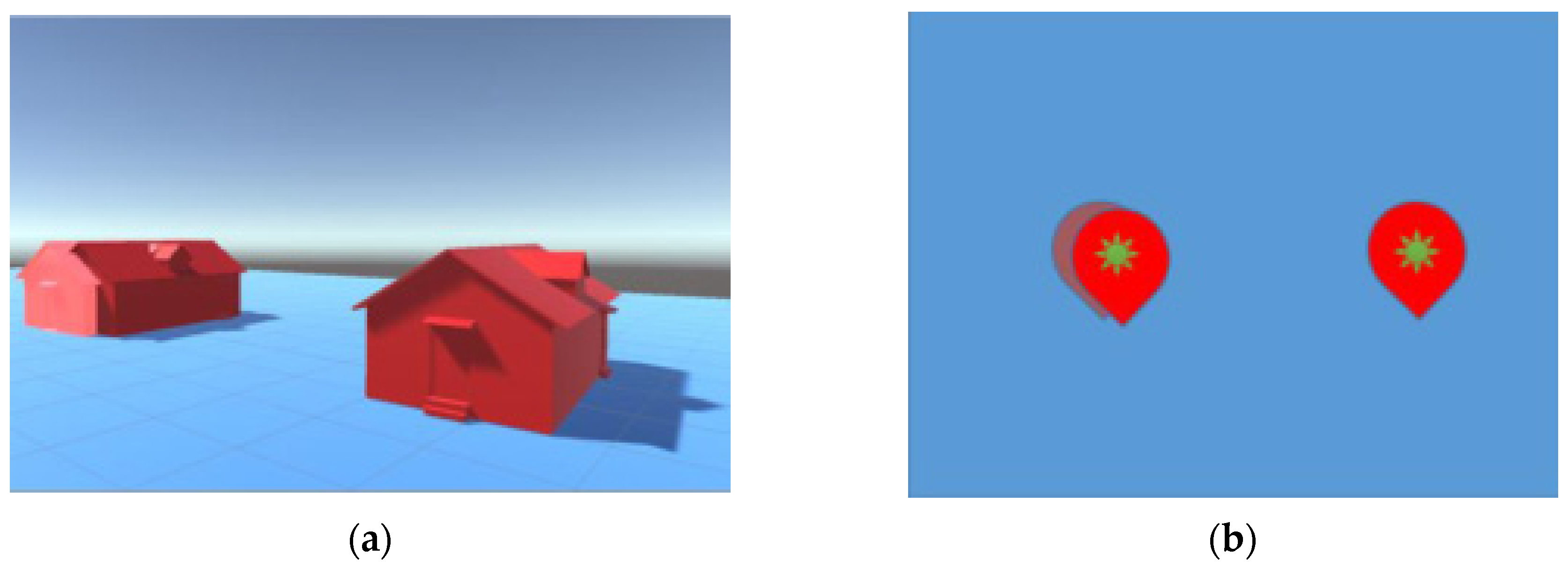
Uncertainty. It is difficult to use a representation to point out that data has uncertainty, without introducing too much noise into the scene. According to several works, the best techniques are based on changing the color of the Marker. For this reason, a mask would be applied to the object with uncertainty, which consists of applying a lighter coloration. The object with uncertainty can be replicated graphically, in this case, it will be necessary to indicate that the object is present in the scene, with a technique that duplicates the original Marker, but with a slight offset, which indicates to the user that this is so.
Figure 6 depicts a representation scheme that follows this philosophy.
3. Implementation
It is applied the METHONTOLOGY methodology [
20] to design and implement an ontology that represents the visualisation model. The ontology is called STEVO (Spatio Temporal visualisation Ontology) and can be freely downloaded from the public Github repository [
21].
In the ontology design and implementation were considered the content of the previuos research, the requirements of the visualisation model, and the decision to use the ontologies:
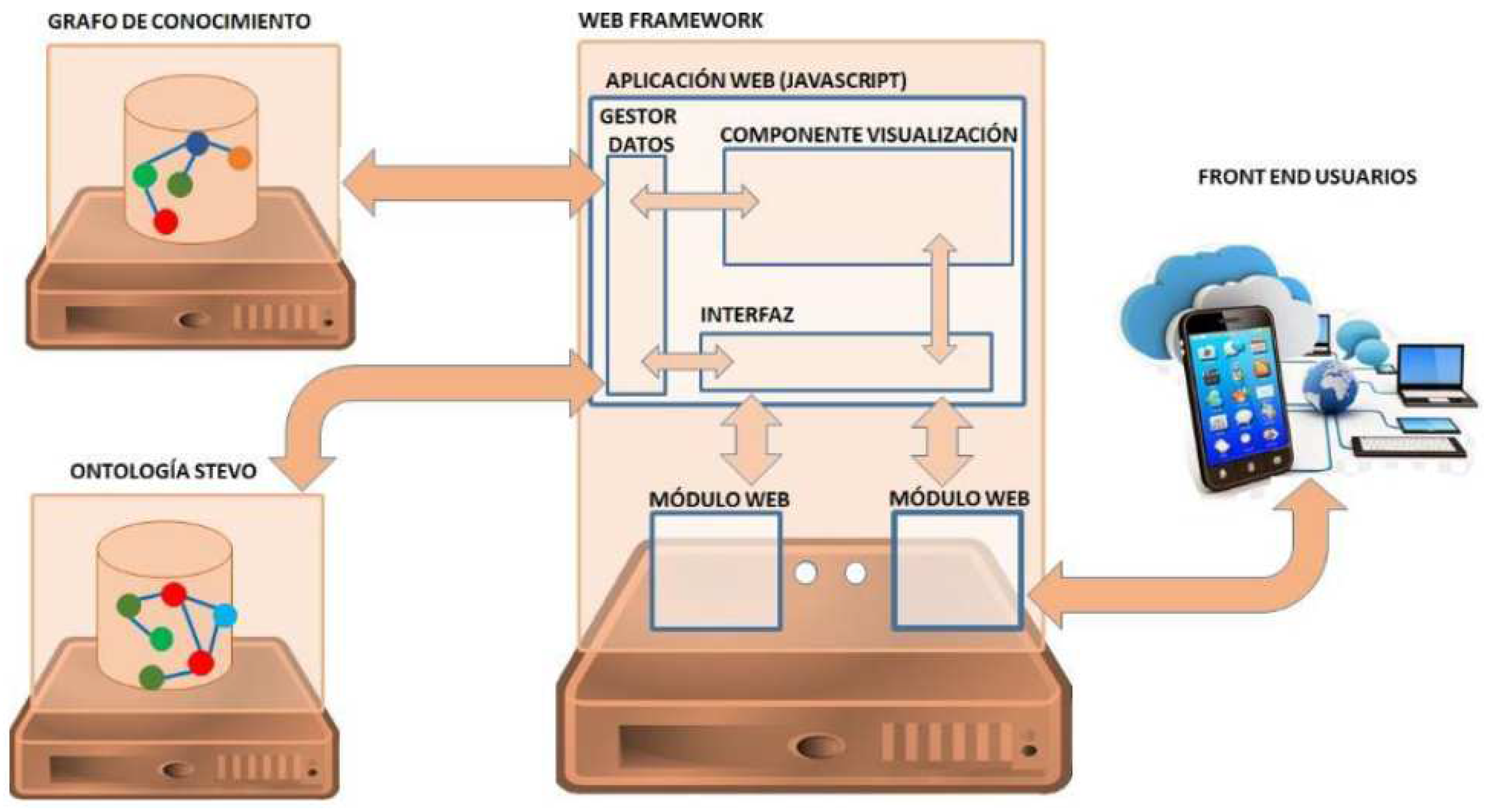
Once the ontology has been implemented, the next step is to implement an architecture, which through a web application allows access to the STEVO ontology, and the data domain, to visualise it completely, or a part of the same result of a query. The architecture of a system capable of supporting this functionality requires considering the following elements:
A hardware and software design to support and allow to access to the content of the STEVO ontology.
Define and develop the modules to access the content of the knowledge graph.
The use of web support, to be able to deploy the web application.
Development of a visualisation component that allows visualisation of data in 2 and three dimensions on web platforms
Figure 7 shows a scheme with the proposed architecture. Where the developments to be carried out would be completely in the web application, which would be based on JavaScript. The visualisation component would be developed in WebGL, which allows viewing and interacting with 2D and 3D graphics, works in most of the main browsers and operating systems on the market. The final implementation was made with the Node.js framework, based on Javascript, the N3.js library to process the STEVO ontology and Unity3D for visualisation.
More details on the design and implementation of the ontology, as well as the visualisation tool, are explained in the doctoral thesis of Javier Sevilla [
22]
4. Assesment
The STEVO ontology and the visualization tool, once developed, have been incorporated and evaluated in the SILKNOW and L’Arxiu Valencià del Disseny (AVD) projects.
The SILKNOW project (Silk heritage in the Knowledge Society: from punched cards to bigdata, deep learning and visual/tangible simulations) funded by the European Union, within the research and innovation program, with the code 769504. The objective is to develop a computer system, where the information is supported by a knowledge graph based on the CIDOC-CRM model, designed to improve the current understanding of the European cultural heritage related to fabrics made with silk. Among the project’s developments is a web browser, where the search results must be displayed on an interactive map, allowing interactive navigation and space-time filters.
The interactive map is a web application, created with the tool exposed in this work, which processes an instantiation of the STEVO ontology, also available on the STEVO public Gthub, within the examples section. In
Figure 8 three screenshots are exposed with the results of this tool. In the figure, on the left, the relationships between the objects are displayed through lines, it is also observed that some objects have a lighter color, due to their uncertainty. Next to the previous screenshot are depicted another screenshot with the same objects but showing the relationships through the ring structure commented on the display model. Finally, on the right, the capture contains a simultaneous display of data at different moments in time.
The usability results of the SILKNOW visualization tool have been evaluated using the Usability Scale System (SUS) [
23], obtaining results above 70, when it was not fully developed. In addition, the tool has also been evaluated at a technical level, subjecting it to stress tests with different computer systems. It only showed technical problems in sets of more than 30,000 data and the computers with the worst characteristics. This is because the tool does not paginate the information, which will be fixed in future versions. For more details about this evaluation, you can consult the deliverable D.7.3 of the SILKNOW project, publicly accessible on the project website [
24]
L’Arxiu Valencià del Disseny, stands as a center for the custody, conservation, cataloging and digitization of the documentation generated by designers, design studios, and the design departments of the main Valencian companies, so that they can be consulted, studied and made available to researchers on design and modern culture, analyzing, based on original documentation, the processes of creation, production, dissemination, sale and use of objects. All this with the purpose, not only of custody and study, but also with the interest of making available to the productive and industrial fabric digitized and related funds through analytical tools and conceptual and product maps capable of promoting innovation and the creativity of the industrial sector.
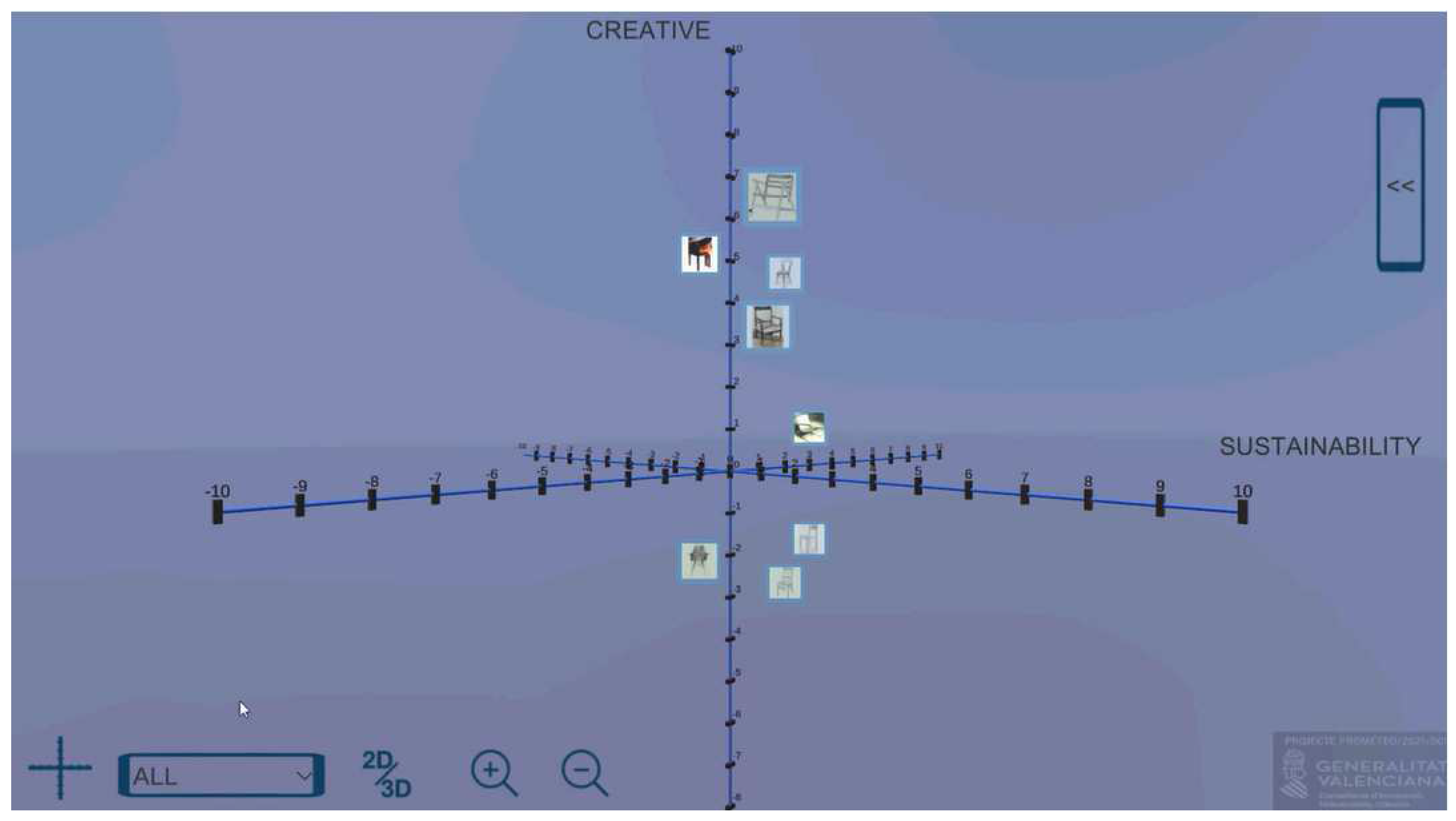
In this project, an interactive map with information about the fabrics must be represented, a product map, and a relationship map. All these elements must be specified using the STEVO ontology and displayed with the visualization tool. At the time of writing this document, the most developed modules are the interactive map, like SILKNOW, and the Product Map. The Product Map is a tool for design professionals, which shows various products in two and three dimensions, according to values that the user can modify. The goal is to visually detect common aspects of the chosen products, to define a base on which to generate innovative designs.
Figure 9 shows a screenshot of the Product Map, which is still developed as a prototype. This tool was evaluated during the workshops of the CREALAB project [
25], celebrated in 2022 in Poland, Italy, and Spain. The evaluation was performed with 31 university students and was applied a System Usabiity Scale (SUS) where the results gathered are like the obtained with the SILKNOW project.
5. Discussion
After the work was carried out, the following conclusions were drawn.
An ontology called STEVO has been designed and implemented as a proposal to represent the previously described model. This ontology is implemented in OWL and is publicly available.
After analyzing the libraries that allow graphic representation in two and three dimensions on a web application, a proposal for the implementation framework designed in this work has been developed. The chosen platform has been WebGL, generated with Unity3D, due to its power, performance and its integration in most current browsers and operating systems, which makes development a multiplatform solution.
The designs and developments carried out have been integrated into two cultural heritage projects, where the data is supported in a knowledge graph. In both projects, different visualizations were developed and validated by several users, from different countries, obtaining a satisfactory result.
The future lines of action with the technologies designed and developed are related to software and ontology improvements:
Eliminate the existing limitation on the size of the data set. In the current version, too much responsibility is delegated to the WebGL display component and there is no data paging management, or data prompting based on the zone and current level of detail. This situation causes the memory issues detected in the load tests. To solve it within the Javascript language, the use of Service Worker technology [
26] will be essential, which allows running background processes in Javascript.
Define new time and space variables. The STEVO ontology allows to define on each scene a temporal visual property, and a spatial one, of reference in the scene. This limitation is important, since the user of the system may want to see where and when the data has been produced but could also want to know where it is now, and since when it has been in that location. For this reason, it is necessary for a STEVO scene to be able to define several visual properties, related to time and space, associated with the different behaviors.
Improve the graphic elements and create new base scenes so that projects can use them easily.
Funding
This research was funded by project Arxiu Valencià del Disseny: shaping the future, designing the present, rescuing the past, funded by Generalitat Valenciana with the code PROMETEO/2021/001. This research was also funded by SILKNOW project (Silk heritage in the Knowledge Society: from punched cards to bigdata, deep learning and visual/tangible simulations) funded by the European Union, within the research and innovation program, with the code 769504.
Conflicts of Interest
The authors declare no conflict of interest.
References
- Garcia-Moreno, M. A.; Hernández-Pérez, T. Patrimonio Cultural Europeo Digitalizado: Europeana. PRAGMATIZES 2019, 140–155. [Google Scholar] [CrossRef]
- European Commission. Commission staff working document evaluation of the commission recommendation of 27 October 2011 on the digitisation and online accessibility of cultural material and digital preservation (SWD/2021/0015 final). Available online: https://eur-lex.europa.eu/legal-content/EN/TXT/PDF/?uri=CELEX:52021SC0015&from=EN (accessed on 20 April 2023).
- Europeana Pro. Available online: https://pro.europeana.eu/ (accessed on 20 April 2023).
- Network of European Museum Organisations. Final report Digitasitation and IPR in European Museums. Available online: https://www.ne-mo.org/fileadmin/Dateien/public/Publications/NEMO_Final_Report_Digitisation_and_IPR_in_European_Museums_WG_07.2020.pdf (accessed on 20 April 2023).
- Aga Khan Documentation Center AT, MIT, 2019. Available online: https://layercake.mit.edu/ (accessed on 20 April 2023).
- British Museum and Google Cultural Institute. 2015. Available online: https://britishmuseum.withgoogle.com/ (accessed on 20 April 2023).
- Sevilla, J.; Casanova, P.; Samper, J.J.; Portales, C. ; Semap: A Project on sematisation and visualisation of cultural heritage data. In Proceedings of the 11th Euro American Conference on Telematics and Information Systems (EATIS 22). 2022. Association for Computing Machinery, New York, USA, 1-8., Article 4. [CrossRef]
- IMATEX. Textile 8784. Available online: http://imatex.cdmt.cat/fitxa_fitxa.aspx?m=n&num_id=8238&t=616 (accessed on 20 April 2023).
- Portalés, C.; Sebastián, J.; Alba, E.; Sevilla, J.; Gaitán, M.; Ruiz, P. and Fernández, M. Interactive Tools for the Preservation, Dissemination and Study of Silk Heritage—An Introduction to the SILKNOW Project. Multimodal Technol. Interact. 2018, 2, 28. [Google Scholar] [CrossRef]
- Arxiu Valencià del Disseny: shaping the future, designing the present, rescuing the past. Available online: https://arxiuvalencia.eu (accessed on 20 April 2023).
- Bolivar, H.; González, R.; Sanjuán, O. Ontology of a scene base don Java 3D architecture. International Journal of Interactive Multimedia and Artificial Intelligence, 1 (2), pp. 14-19. 2009.
- Polowinski, J. and VOIGHT, M. VISO: A shared, forma knowledge base as a foundation for semi-automatic infovis systems. CHI EA’13: Extended Abstracts for Human Factors in Computing Systems. New York, USA: Association for Computing Machinery, pp. 1791. [Google Scholar]
- Polowinski, J. Towards RVL: a declarative language for visualizing RDFS/OWL data. In 2013. In Proceedings of the 3rd International Conference on Web Intelligence, Mining and Semantics (WIMS ‘13). Association for Computing Machinery, New York, NY, USA, 1–11., Article 38. [CrossRef]
- Sobral, T.; Galvao, T. and Borge, J. An ontology-based approach to Knowledge-assisted Integration and Visualization of Urban Mobility Data. Expert Systems with Applications. 2020. Vol. 150. pp. 113260. [CrossRef]
- Hengl, T.; Roudier, P.; Beaudetter, D. and Pebesma, E. PlotKML: Scientific Visualization of Spatio-Temporal Data. Journal of Statistical Software. Vol. 63(1), pp.1-25. [CrossRef]
- Jaffali, S.; Jamoussi, S.; Kheli, N. and Hamadou, A.B. Survey on Social Networks Data Analisys. Innovations for Community Services. 2020. Springer International Publishing, pp. 100-119. [CrossRef]
- Bekiari, C.; Bruseker, G.; Doerr, M.; Ore, C.E.; Stead, S. & Velios, A. Definition of the CIDOC Conceptual Reference Model v7.1.1. 2021. The CIDOC Conceptual Reference Model Special Interest Group. [CrossRef]
- W3C. Time Ontology in OWL. 2020. Available online: https://www.w3.org/TR/owl-time/ (accessed on 20 April 2023).
- Abadie, N.; and Atemeizing, A. Ontology of coordinates reference systems. 2015. Available online: http://data.ign.fr/def/ignf/20150505.en.htm#classes (accessed on 20 April 2023).
- Corcho, O.; Fernández-Lopez, M.; Gómez-Pérez, A. and López-Cima, A. Building Legal Ontologies with METHONTOLOGY and WebODE. In: Benjamins, V.R., Casanovas, P., Breuker, J., Gangemi, A. (eds) Law and the Semantic Web. Lecture Notes in Computer Science(), vol 3369. 2005. Springer, Berlin, Heidelberg. [CrossRef]
- Sevilla, J. STEVO Ontology. Available online: https://github.com/javier-sevilla/STEVO (accessed on 20 April 2023).
- Sevilla, J.; Samper, J.J.; Fernández, M. Visualización del contenido de grafos de conocimiento del patrimonio cultural. Phd. Avaiable online: https://roderic.uv. (accessed on 20 April 2023)1055. [Google Scholar]
- Brooke, J. SUS: a retrospective. 2013. Journal of Usability Studies. Vol. 8 (2). Pp. 29-40.
- Silknow web. 2022. Available online: https://silknow.eu (accessed on 22 April 2023).
- Crealab web. 2022. Available online: https://www.uv.es/crealab/ (accessed on 22 April 2023).
- Google. Service Worker. 2022. Available online: https://developers.google.com/web/fundamentals/primers/service-workers (accessed on 22 April 2023).
|
Disclaimer/Publisher’s Note: The statements, opinions and data contained in all publications are solely those of the individual author(s) and contributor(s) and not of MDPI and/or the editor(s). MDPI and/or the editor(s) disclaim responsibility for any injury to people or property resulting from any ideas, methods, instructions or products referred to in the content. |
© 2023 by the authors. Licensee MDPI, Basel, Switzerland. This article is an open access article distributed under the terms and conditions of the Creative Commons Attribution (CC BY) license (https://creativecommons.org/licenses/by/4.0/).
