Preprint
Article

Montane Ecoclines as Social Aggregation Zones in Ancient Central Asia: Agropastoral economies in Jukuu, Kyrgyzstan

Altmetrics

Downloads

140

Views

44

Comments

0

A peer-reviewed article of this preprint also exists.

Submitted:

15 May 2023

Posted:

24 May 2023

You are already at the latest version

Alerts
Abstract
This paper uses preliminary studies of archaeological sites (burial mounds and settlements) from the Iron Age through Medieval periods (ca. 800 BCE to 1200 CE) in the Juuku Valley on the South side of Lake Issyk-Kul to model land-use across vertical mountain zones. To do so, we have established a radiometric chronology, conducted test excavations of an Iron Age settlement and a Turkic period burial, undertaken preliminary archaeobotanical research, and pedestrian surveys. Seed remains of wheat (Triticum aestivum), barley (Hordeum vulgare), broomcorn millet (Panicum milaceum) and foxtail millet (Setaria italica) and legumes were recovered in very small quantities from an Iron Age upland settlement at 2100 m asl and a Turkic period burial mound at 1934 m asl. These preliminary archaeobotanical results are compared to the Talgar Iron Age settlements on the north side of the Tian Shan Mountain range in Kazakhstan studied earlier by Robert Spengler. Small samples of faunal remains found at the Turkic period kurgan and from a profile at the upland Iron Age settlement indicate livestock herding of sheep/goats, cattle, and horses in Juuku Valley. The goal of this paper is to test the hypothesis that pastoral transhumance and agropastoralism were economic strategies used by ancient societies during the Iron Age through Medieval periods in mountain-river valley areas between 750 m to 2500 m asl. These economic strategies that combined the pasturing of sheep, goats, cattle and horses with the cultivation of cereals were adapted to the use of different vegetational zones along a vertical gradient. This paper based on preliminary research of upland sites of the Juuku Valley in Kyrgyzstan, initiates a long-term research study of four millennia of settlements that ranged from pastoral transhumance, pastoral nomadism, and combined mountain agriculture using survey data and test excavations.
Keywords: 
Subject: Environmental and Earth Sciences  -   Ecology

1. Introduction

We report on the preliminary results of archaeological survey and excavations conducted in 2021 and 2022 in the Juuku Region (see Figure 1, Map of the Juuku Valley). As a result of our ongoing research, the importance of different ecozones along a vertical gradient between 1600 m asl and 2100 m asl is becoming more evident. Some of this ecological mosaic is expressed as ecotones along a set of environmental gradients and determined by factors such as elevation, climate, and soil types. Ecotones are transitional zones within an ecosystem that usually are the sites of greater species diversity (richness) and greater variability within a species and a community [1]. Social scientists, including geographers, anthropologists, and archaeologists have noted that ecotones are not only natural “edges” between environmental zones but can also be “cultural edges” where innovation and multiple resource-collecting, exchange, collective gathering, and other social activities take place [2]. Spengler et al. [3] have theorized the use by Bronze and Iron Age pastoralists of vegetation resources for grazing and for foraging in the mountain-steppe interface regions of Central Asia, notably within ecotopes or patches of the ecological mosaic along a rich ecotonal foothill belt. We explore the concepts of ecotone, ecotope, and “cultural edges” as we put forth a model for agropastoralism over the last four millennia of human history in this region. The ancient Bronze and Iron Age populations used the mountainous areas of the Tian Shan region to practice both pastoralism of sheep, goats, cattle, horses (and in some cases yaks) and to cultivate grains such as wheat, barley, foxtail millet and broomcorn millet [4,5,6,7,8,9]. These mountain ecoclines or vertical gradients were important resource loci for ancient populations Agropastoralism as an economic strategy for Central Asia has been contrasted to more mobile forms of pastoral nomadism, resulting in an ongoing debate over whether ancient peoples fell on the spectrum btween the two systems [10,11,12].

1.1. Theoretical Perspectives

Our goal is to lay out some initial hypotheses which we can begin to test using new lines of evidence emerging from our archaeological surveys and excavations in the Juuku Valley [13,14]. Humans are drawn to ecotones because such transitional zones often have greater species biodiversity, and manifest greater resilience to climate change and other natural hazards [15]. Archaeologists and others have observed that ecotones are attractive for human -settlements especially littoral belts, riparian swaths, forest margins, glacial edges, and mountains foothills [16,17,18]. Ethnographers working in the Himalayas have noted that in high altitudes, human populations will seek out a diverse set of land-use strategies for using seasonal meadows, benefitting from glacial snow melt, and niches or micro-environmental pockets [19]. The role of mountain foothills in particular, as zones of population aggregation and as corridors of communication have been discussed as ideal laboratories for examining environmental sustainability, especially due to spatial, temporal, and climatic shifts [16,20,21]. These “cultural edges” facilitate “social and economic activities and meeting places where knowledge and goods are produced and exchanged” [2]. The importance of the mountain/steppe ecotone for prehistoric human populations in Central Asia has been recognized by several scholars [3]. For examples, Kuzmina [22] refers to the mountainous spine of Central Asia as a prehistoric Silk Road, and Frachetti [11] coined the moniker “Inner Asian Mountain Corridor”, later rebranded under other banners [21], but all referring to the same process of people congregating in the mountain foothills, facilitating agropastoral production and social exchange. Frachetti [11] proposed that herding economies (sheep, goat, cattle, and horse-based pastoralism) contributed to the development of mountain passageways that later developed into major networks for exchange and trade. Later Frachetti and his colleagues [24] used a flow accumulation model to explain pastoral movement across the mountainous regions of the Inner Asian study zone at elevations from 750 m asl to 4000 m asl.
Over the past few decades, archaeological research has illustrated that the population densities and processes of cultural exchange in these mountain river valleys stretches back in time at least to the early Holocene [24,25,26,27,28,29] and forward at least to the Mongol Conquests [20,30]. The role of rich river valleys in facilitating agricultural economies during the Iron Age (800BC-AD400) is an important topic of inquiry, as this is the period when unified nomadic polities in Eurasia are theorized to have first consolidated their influence over vast territories of Central Eurasia [31,32,33] and when highly mobile “nomadic” economies are traditionally thought to have first formed [34]. Archaeological inquiry in the mountain foothills of the Tian Shan and northern Pamirs over the past two decades has already challenged both aspects of this traditional narrative [9,35,36,37,38,39,40,41,42]. Although, excavations of sedentary village sites in the Tien Shan by Baipakov [43] and Akishev [44] had already challenged these “nomadic narratives [10] a few decades prior.
The first scientific investigations into these questions, at the sites of Tuzusai, Tseganka 8, and Taldy Bulak, in the 1990s and early 2000s demonstrated that these small village sites consisted of dense cultural deposits, seemingly sedentary domestic structures, agricultural remains, and elaborate material culture assemblages [4,9,38,39]. However, this research has, until now largely been restricted to one key alluvial fan, the Talgar, over the past few years, we have undertaken archaeological research at a series of sites in northern Kyrgyzstan to study how widespread these cultural phenomena were during the Iron Age along the broader mountain foothill belt. This paper is based on preliminary studies conducted in 2019 through 2022 in the Juuku Valley on the south side of Lake Issyk-Kul and earlier archaeological research conducted from 1994 to 2018 on the Talgar alluvial fan on the northern edge of the outer Tian Shan range (see Figure 1. Map showing Juuku Valley and Talgar Fan).
In contrasting archaeological evidence from contemporaneous sites on opposite sides of Lake Issyk-Kul, on the Talgar fan (northern Tian Shan) and in the Juuku Valley (central Tian Shan), we seek to examine the possible role of vertical zonation and the development of agropastoralism, with a possible seasonal pastoral transhumance component, in the mountainous regions of Central Asia. The sites of both the Talgar alluvial fan (550 l to 1150 m asl) and the Juuku Valley (1600 to 2100 m asl) are represented by Iron Age occupations, but the Juuku archaeology shows evidence of human occupation from at least the Bronze Age to the present. Both the Talgar fan and the Juuku Valley are situated on the north-facing slopes of their respective mountain ranges. Our goal in examining these two polygons is to isolate a set of environmental and economic conditions that shape the development of agropastoral and pastoral transhumance systems in the Tian Shan Mountains. Although, we focus primarily on the first millennia BCE, a period traditionally recognized as marking the rise of ancient nomadic confederacies, such as the Saka (eastern variants of the Scythians), we will also discuss the later periods of Saka, Wusun, and Turkic, up to the early Medieval period (ca. 200 BCE to 900 CE). Data from survey and test excavations from the Middle and Eastern Juuku were collected during the 2019, 2021, and 2022 field seasons by the Kyrgyz-American Tian Shan Project [13,14].
Other archaeologists working in the Issyk Kul Basin have hypothesized that the Bronze Age populations occupied hamlets or small villages such as at the site Chap site in the Kochkor Valley [5,6,7,8]. These earlier settlements probably were followed by later Iron Age settlements. In cemetery complexes subsequently correlated with the Wusun and then later Turkic groups found throughout the Issyk-Kul region [45] there is evidence for the use of the mountain foothills and gorges as prime locations for ritual landscapes. Khazanov [46] and others have stressed the degree of variability in the economic foundation of nomadic pastoral groups, both ethnographically and in the past. Nonetheless, the term “nomadism” has led to considerable confusion among the researchers of Eurasian steppe societies. Rather than pigeonholing pastoralism into rigid typologies, we hope to draw parallels between recent ethnographic and geographic descriptions of high mountain farming and herding in north Pakistan with ancient patterns of land use.

1.2. Our Model

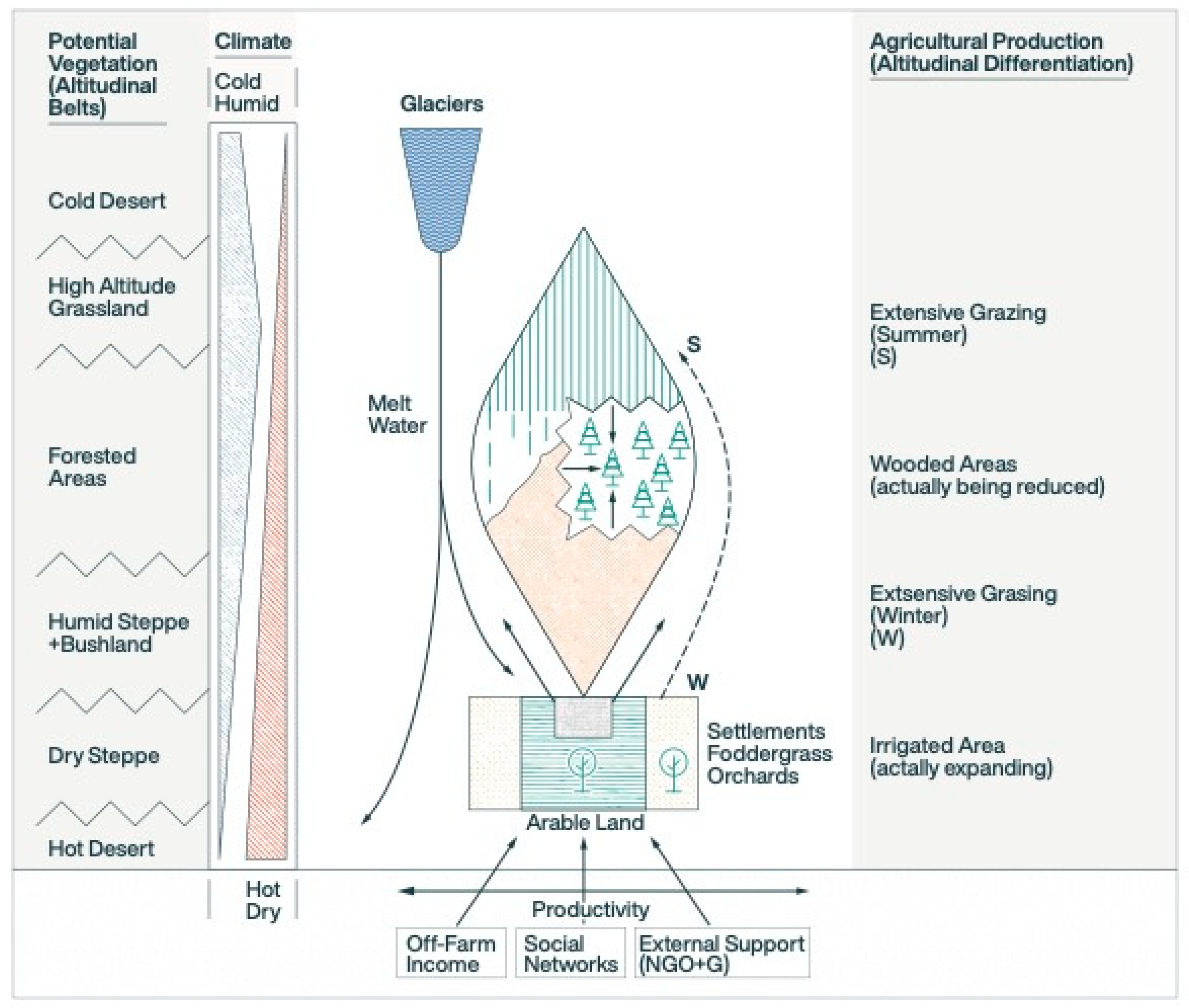
Drawing on the in-depth ethnographic studies of pastoralist groups in north Pakistan by a team of German researchers [19], we seek to test the existence of three different systems of mountain-steppe pastoralism in semi-arid environments during the first millennium BCE through the end of the first millennium CE: (1) mountain nomadism; (2) pastoral transhumance; and (3) combined mountain agriculture (for the Juuku Valley this is labelled as mountain agropastoralism). The ethnographers looked specifically at elevations ranging from 2000 to 5000 m asl, below the snowline of the Eastern Hindu Kush, the Karakorum, and the Western Himalayas [19] (Figure 4). As a complicating caveat, we recognize that the north Pakistan landscape described here is considerably higher in elevation and has many microenvironments that make it conducive for agriculture up to very high altitudes, yet the descriptions of agropastoral use of vertical resources provides us with some useful comparisons. Our elevation ranges are considerably lower, from 750 to 1150 m asl (Talgar region, southeast Kazakhstan) to the upper gorge areas of the central Tian Shan in the middle elevation ranges of 1600 to 2200 m asl (Juuku Valley region, south side of Lake Issyk kul). We specifically chose the north Pakistan as a study area because of ethnographic descriptions of an interlocking land use system along a vertical gradient in a mountainous region. The Talgar and Juuku areas also represent different elevation gradients and today show different patterns of agricultural and pastoral land use. We can then hypothesize about the nature of interlocking ancient settlement-subsistence patterns in the Juuku and Talgar areas. To understand the Ehlers and Kreuhtzmann [19](p.10) model we show a diagram of vertical vegetation zones and agricultural production (see Figure 2).
Their descriptions of the high mountain economic systems are as follows: Mountain nomadism in north Pakistan that takes place at the edge of glaciers is usually carried out by distinct ethnic groups, such as the Gujurs (although some have now settled in lower valleys) with their mixed herds of sheep, goats, cattle and yaks as well as camels, horses and donkeys but they also engage in transportation and trade activities [19] (p.13). To date, we have no ancient examples of mountain nomadism, at the upper mountain elevations in Kyrgyzstan there are herdsmen who keep yaks as well as other herd animals. We have observed yak herding and versions of mountain nomadism in the Semenovsky Gorge on the north side of Lake Issyk Kul.
Pastoral transhumance is a system where seasonal migrations of sheep, goats and cattle use summer pastures in the mountains and winter pastures in the lowlands. In the Talgar region, nearby foothills and plateaus at 1800 m asl or above are used today by Kazakh herders who work for collectives or for individual families will graze their herds of sheep, goats, cattle and horses on summer pasture or jailau. Then these Kazakh herders will use lowland pastures either on the Talgar alluvial fan or in more distant lowland areas during the winter months. Ferret [47] has examined mobile pastoralism in southeast Kazakhstan in the Raimybek District in the Almaty Oblast by comparing statistical and ethnographic accounts from 1910 with her own ethnographic research in 2012. There the use of vertical altitudinal and vegetational zones have been exploited by seasonal transhumant pastoralists for more than one-hundred years [47]. In the Darkhent District (Raimybek District nowadays) in 1910 government statistics indicate that only 3.6 percent of the population was sedentary (year-round), while 68.5 percent practiced agriculture [47] (p.510). The total livestock holdings for Darkhent in 1907 were 69 percent sheep, 12 percent goats, 10 percent horses, 9 percent cattle, and less than 1 percent camels and in 1967 the average Raimybek household had 63.8 percent sheep and goats, 8.5 percent horses, 6.4 percent cattle, and 0.3 percent camels [48]. The general pattern of mobility is consistent over the last one-hundred years. In 1994, Ferret [48](p.514) undertook a transhumant journey with Kazakh herders and their mixed herds of 470 sheep and goats, 21 cattle including some calves, 13 horses, 1 donkey and a dog. who traveled in early June from the winter pasture in the foothills of south-facing slopes of Tory Aighur at 1500 to 1800 m asl, south to the high mountains of Kungei Alatau in 2000 to 2500 m asl.
Combined mountain agriculture takes place in north Pakistan at elevations of 2000 to 3500 m asl and consists of households who cultivate cereals such as wheat, barley, and millet along with maize during the growing season and graze their animals on high mountain pastures in the summer and stable their small numbers of animals in the winter where they can be fed hay and fodder. These households organize labor to move between fields and pastures but live year-round in sedentary villages in Yasin Valley where they will grow maize, barley, millets, some legumes including alfalfa, vegetables and fruits as well as small numbers of sheep and goats, cattle (oxen), and donkeys [49] (pp.39-49). Horses and yaks are rarely kept in these households. Each household was reported in a 1982-1983 census to have between 8 and 13 sheep and goats, 3 to 5 cattle, and 2 to 7 chickens, and some households an occasional donkey, horse or yak [49] (p. 43). There may be rare instances of high mountain agropastoralism (the local version of combined mountain agriculture) in the Juuku Valley although we have observed agriculture (cultivation of barley, tree crops, and vegetables) in conjunction with the keeping of sheep, goats, cattle, and horses at elevations of 2000 above in villages and hamlets in the Juuku Valley where combined mountain agriculture occurs in summer months nowadays, rarely during the winter months. In eastern Kazakhstan Marcus Hauck and his colleagues [50] have collected interview data from roughly 100 Kazakh households in 2010 and 2011. Among 49 percent of the 50 Kazakh herding household incomes in the Saur Mountain region (1500 to 1800 m asl) income was derived from small-scale farming while only 11 percent of the 49 Kazakh herding household in the Altai Mountains (885 to 1110 m asl) was derived from farming [50] (p.105, p. 108). Obviously these statistics reflect current day market conditions in eastern Kazakhstan available to Kazakh herding households, but they also demonstrate that both seasonal pastoral transhumance or village pastoralism are often combined with farming in mountainous regions of Central Asia.
These ethnographic examples suggest that in the past both agricultural and herding practices were the main subsistence economies available to the ancient populations of the Talgar and Juuku Valleys; it may be possible to postulate that ancient societies also had a series of land-use systems that included mountain nomadism, pastoral transhumance, and mountain agropastoralism. The vertical zonation and the geography of both main valleys and side valleys in the Juuku Valley suggest an interlocking system of agriculture and herding.

2. Materials and Methods

2.1. Study Areas

2.2.1. The Talgar alluvial fan is a 550 m2 area to the north of the northern slopes of the outer Tian Shan range (known as the Zailiisky Alatau) in southeastern Kazakhstan, the apex of the alluvial fan is at N 43.274896 E 77.215245, 1100 m asl)

The Talgar River is glacial fed, originating from Peak Talgar at almost 5000 m asl. The river opens into an alluvial valley or fan below the foothills of the Zailiskii Alatau. The fan itself, although heavily altered today by industrial farming practices and Soviet period agricultural practices, consists of riparian areas and stream tributaries, along with scrub- and semi-arid grasslands (from 1100 to 550 m asl). Archaeological survey (pedestrian walking and analysis of digital map bases) conducted between the mid-1990s and 2018, have revealed over 1000 Iron Age burial mounds and 70-90 Iron Age settlements. Excavations at three of these Iron Age sites has revealed a two-phase chronology: Phase I (400-200/150 BCE) and Phase II (200 BCE to 100 CE [9]. At these sites, zooarchaeological remains of sheep, goats, cattle, and horses, with an occasional camel, donkey, or dog, were recovered [9,51]. The cultivation of wheats (Triticum aestivum/turgidum), barley (Hordeum vulgare), broomcorn millet (Panicum milaeceum), and foxtail millet (Setaria italica), in addition to finds of grape pits and an apple seed have been identified [42,52].

2.2.2. The Juuku Valley is a gorge south of Lake Issyk-Kul, a large saline lake in northeastern Kyrgyzstan.

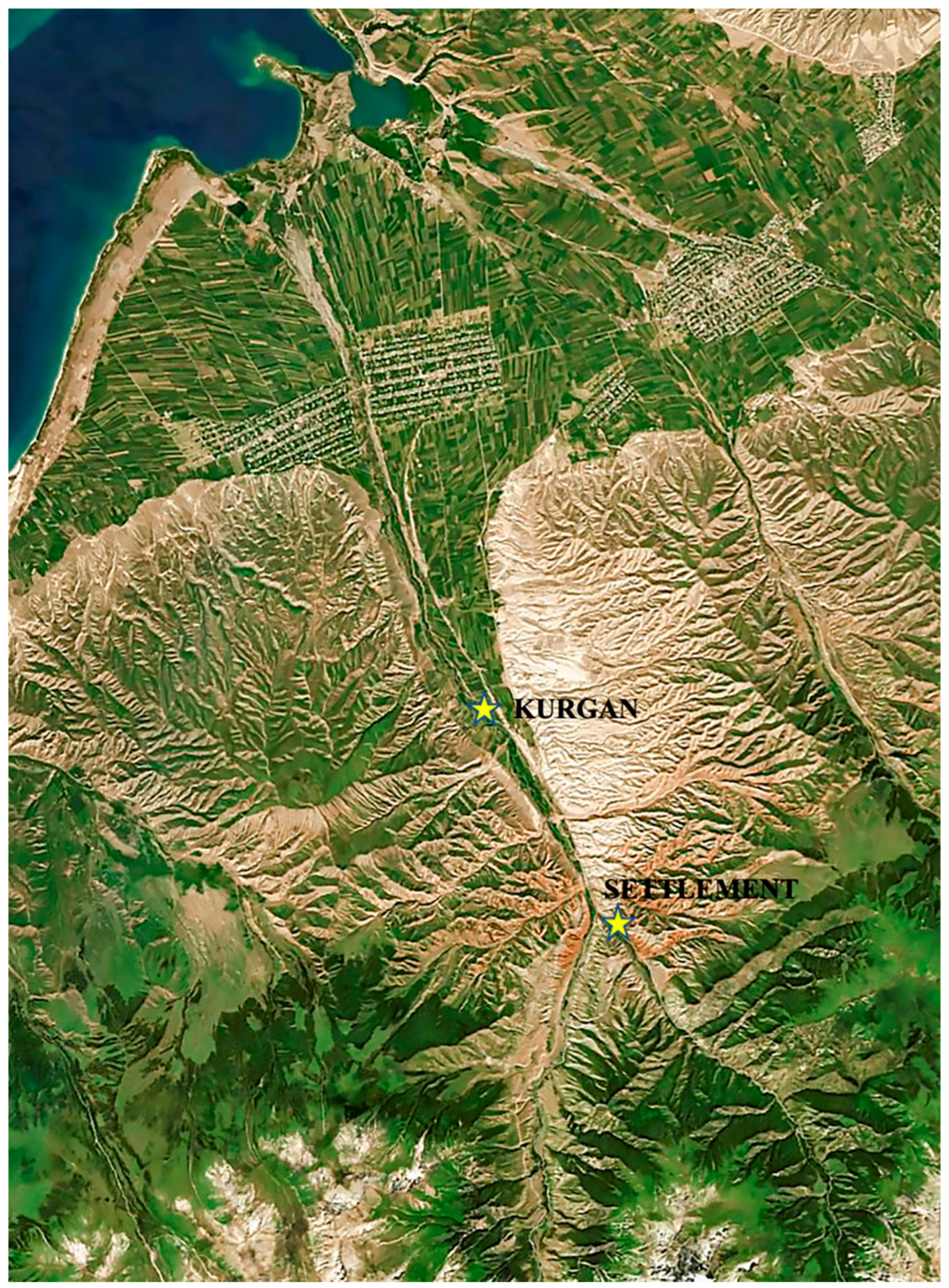
The Juuku Valley is a small intermontane valley; the glacier peak of It Tash, at 4808 m asl, empties into mountain streams of the valley that extend 50 km north and terminate into the Lake Issyk-Kul (see Figure 3.) In the upper elevations, there are conifer forests and high alpine meadows located below the glaciers. Our study area is located in the middle and lower reaches of the valley (2100 m asl to 1600 m asl). In the middle reaches are stands of Tian Shan spruce, pines, and shrub-grasslands. Along the streams are riparian stands of conifers and birches. Today the lower Juuku area is farmed using Soviet methods of heavy equipment tilling and vegetation consists of semi-arid species. The middle Juuku is used as both pasture lands for sheep, goats, cattle, and horses and for orchards (apple and apricot), kitchen gardens, and fields of barley, wheat, alfalfa, and sainfoin. Recent archaeobotanical work by Mir-Makhamad and Spengler will be reported here [14].

2.3. Chronological framework for the Juuku Valley

Table 1 is the chronological framework used for this region of Kyryyzstan.

2.4. Test Excavations and Kurgan excavations

2.4.1. Lower Juuku Kurgan 1 was selected for excavation in 2022 based on its size and configuration

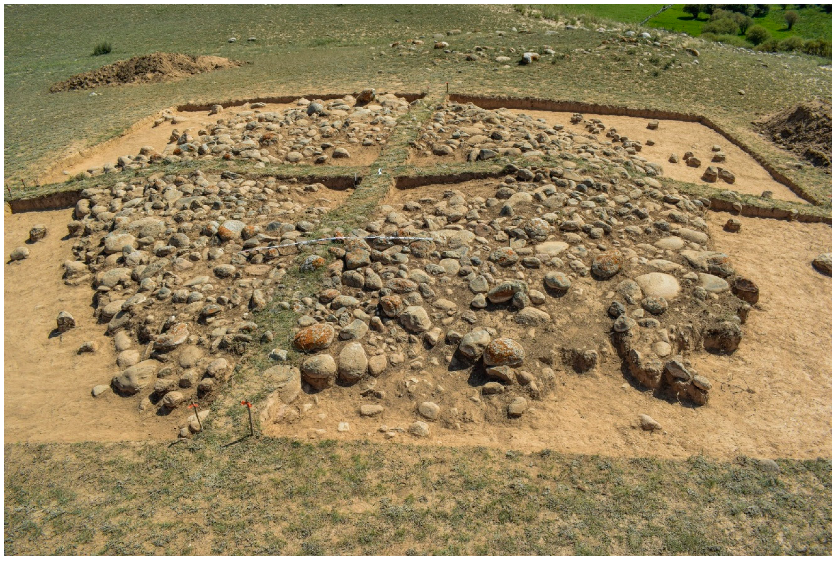
The kurgan is located on an eastern terrace along the Juuku stream, at N 42.248571 E 77.945917, at an elevation of 1934 m asl. It is 8.4 m (east-west) in diameter and 9.9 m (north-south) in diameter. On the surface, the kurgan consists of 2 to 3 layers of stones that form a square enclosure. A central area has few to no stones. The kurgan was divided into four quadrants. The burial monument was photographed leaving four baulk walls (Figure 1. Oblique overhead photograph of the Kurgan).

2.4.2. Block Excavations at Eastern Juuku Settlement 1

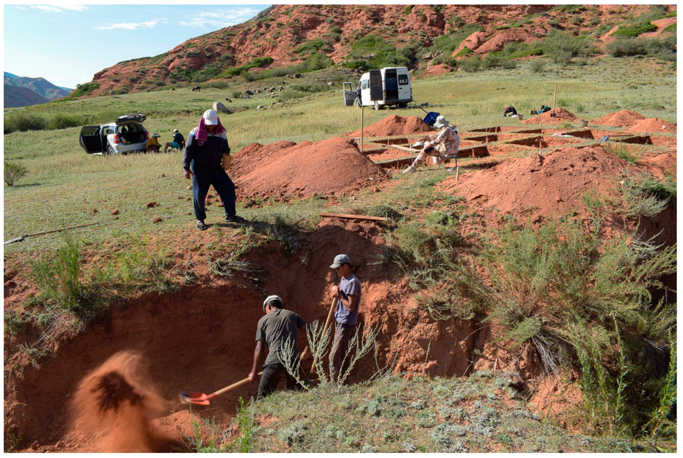
An area 8 x 8 m (64 sq m) was excavated on the eastern terrace of the East Branch of the Juuku stream. The excavations were located above an erosional cut at an elevation of 2090 m asl. The site was excavated in 2 x 2 m units with 25 to 30 cm baulk walls left in place. The excavations were carried out in 10 to 20 cm arbitrary levels (see Figure 5).

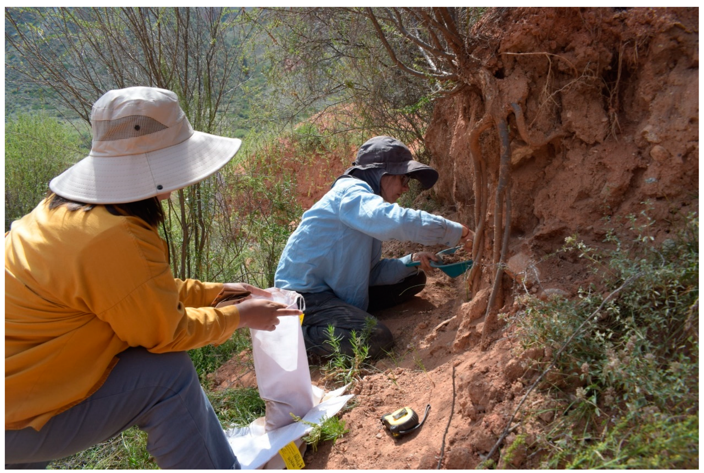
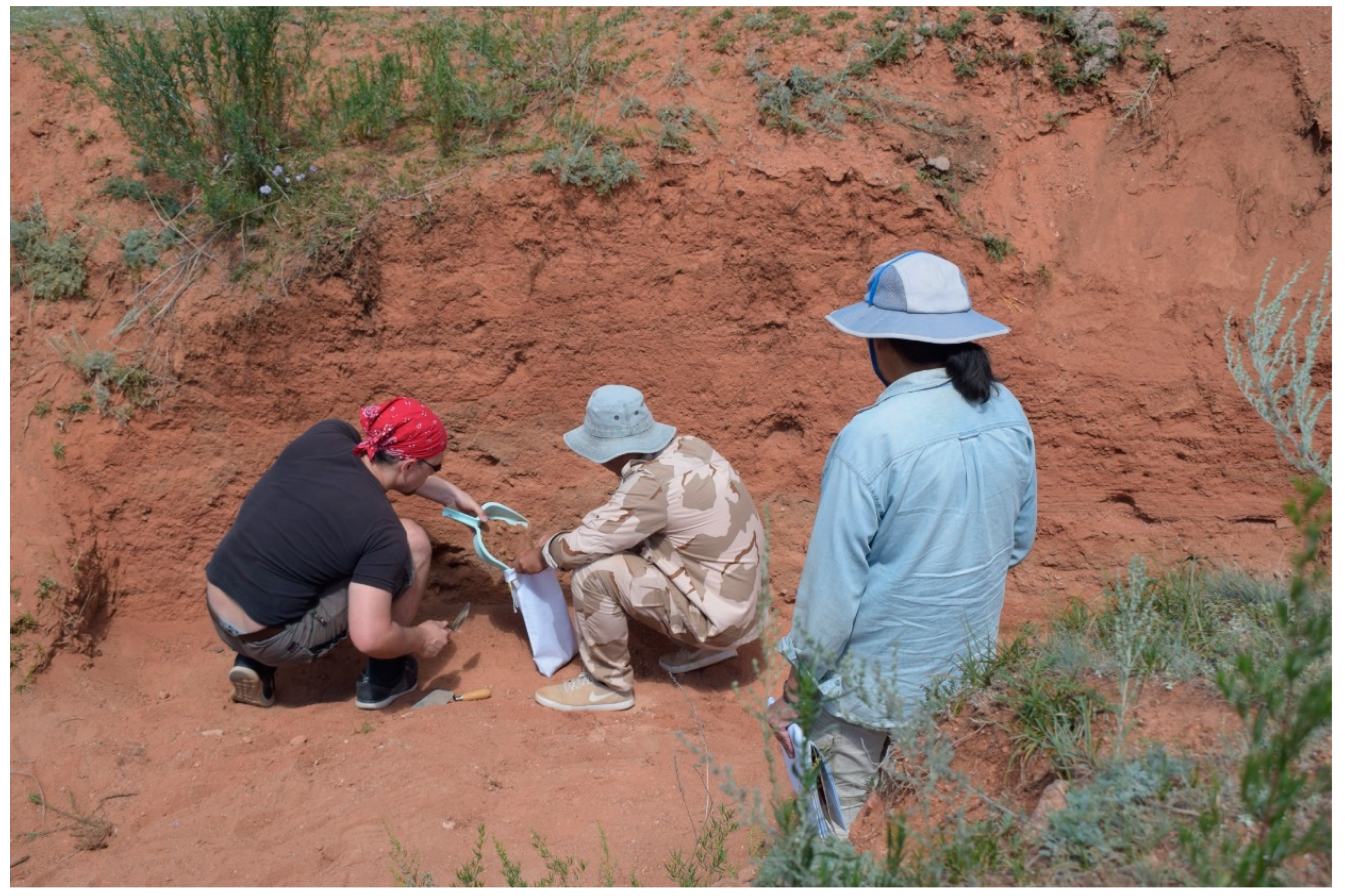
2.4.3. Profiles 4 and 6 were cleaned so that archaeobotanical samples (flotation) could be taken from ashy layers (see Figure 6 and Figure 7)

These profiles are located along the south facing erosional cut exposing the deposits at Eastern Juuku Settlement 1.

2.5. Radiometric dating

Samples have been taken from profiles from two settlement sites in the Eastern Juuku Valley. At Eastern Juuku Settlement 1, an Iron Age site in 2021 and 2022, one radiometric date was taken from a charcoal sample from Profile 1 as well as a wheat and barley grain were dated. Two more radiometric dates were selected from flotation samples taken in 2022 from Profile 4 and Profile 6.
A charcoal sample was taken from Eastern Juuku Settlement 2, a Medieval site in the 2021 field season. Two radiometric samples were taken from Lower Juuku Kurgan 1, a burial mound excavated in 2022, one sample from charcoal found in the eastern part of the grave pit and the other from a charred wheat seed selected from a flotation sample. One radiometric date from charcoal was taken from Lower Juuku Settlement 1, a Kirghiz ethnographic site with a profile of rich charcoal and seed deposits.

2.6. Archaeobotanical Sampling

During the 2022 field season, five sediment samples were collected from LJK1, burial mound (kurgan) and another five samples were collected from profiles found at EJS1, the Iron Age site. Flotation and sorting took place during the field season in Kyrgyzstan using a combination of an overflow tank and bucket systems. Samples from the burial mound were floated using bucket flotation on the site; while samples from the Eastern Juuku settlement and the Lower Juuku excavation unit were transported to the town of Kant and floated using a flotation machine. Sediment samples ranged from 5.0 to 44.5 liters in volume; in total, 124.5 l of sediment were floated and analyzed. The heavy fraction was collected down to 1.4 mm and light fraction down to 0.355 mm. Heavy fraction sorting took place in Kant after the expedition. Only fragmented snail shells and bones were recovered in the heavy fraction. Light fraction was transported to the Palaeoethnobotany Laboratory at the Max Planck Institute for Geoanthropology. Sorting of light fraction was conducted to 0.355 mm.
A poor state of preservation was observed at both sites; in addition, there were many fragments of seeds recovered, which were poorly presented to identify and have not been counted in the totals. The state of preservation was likely due to the nature of sheet midden eroding downslope and, therefore, the contents had been subject to slow colluvial buildup. A specific category of seed fragments, the label Cerealia, was used to describe all domesticated cereal grain fragments that were too damaged and small to assign to either wheat or barley. The Legume category included highly fragmented domesticated legumes that could not be differentiated between different genera. Furthermore, only a few seeds were preserved well enough to be measured (see Table 6 and Table 7). The identification of legumes in the Juuku valley is interesting because before only a few legume seeds were found in Chap I in the central zone of Central Asia; while there is the lack of legumes at other first millennium BCE sites.

3. Results

The results of radiometric dating, archaeobotanical finds, and excavations at LJK1 and EJS1 will be discussed in the following sections.

3.1. The radiometric sequence for Juuku Valley demonstrates that we there are anthropogenic deposits in natural profiles, a burial kurgan, and three settlement sites, all with mudbrick architecture (room structures, fire pits, floors, and other features) that date from the later part of the Iron Age (beginning of the first century CE) to the ethnographic Kyrgyz period.

Eastern Juuku Settlement 1 at 2060 m asl on the eastern branch of the upper Juuku valley along the eastern terrace of a mountain stream valley (see Figure 3). The four radiometric dates of this site fall with a time period of 22 to 536 CE in the Wusun period.
The Kurgan excavations at Middle Juuku at 1900 m asl have resulted in two radiometric dates falling within 660-991 CE, or within the Turkic period/early Qarakhanid time period.
Eastern Juuku Settlement 2 at 2090 m asl on the eastern branch of the upper Juuku valley along the eastern terrace of a mount stream valley (see Figure 3). The two radiometric dates of this site fall within a time period of 978-1151 CE within the Qarakhanid time period.
One charcoal sample from LJS1 found on the middle reaches of Lower Juuku valley dates from cal. AD 1982-1932 (95 percent accuracy). This is important because it demonstrates that the Lower Juuku valley and terraces have been utilized up until present-day occupations.

3.1.1. Kurgan Excavation

Kurgan 1 is one of a group of burial mounds located on the second terrace east of the Juuku River. Unlike many kurgan clusters that follow an alignment or linear cluster, this kurgan is not part of an ordered alignment or arrangement. Kurgan 1 is situated at a high part of the western edge of the terrace such that the mound slopes down toward the east.
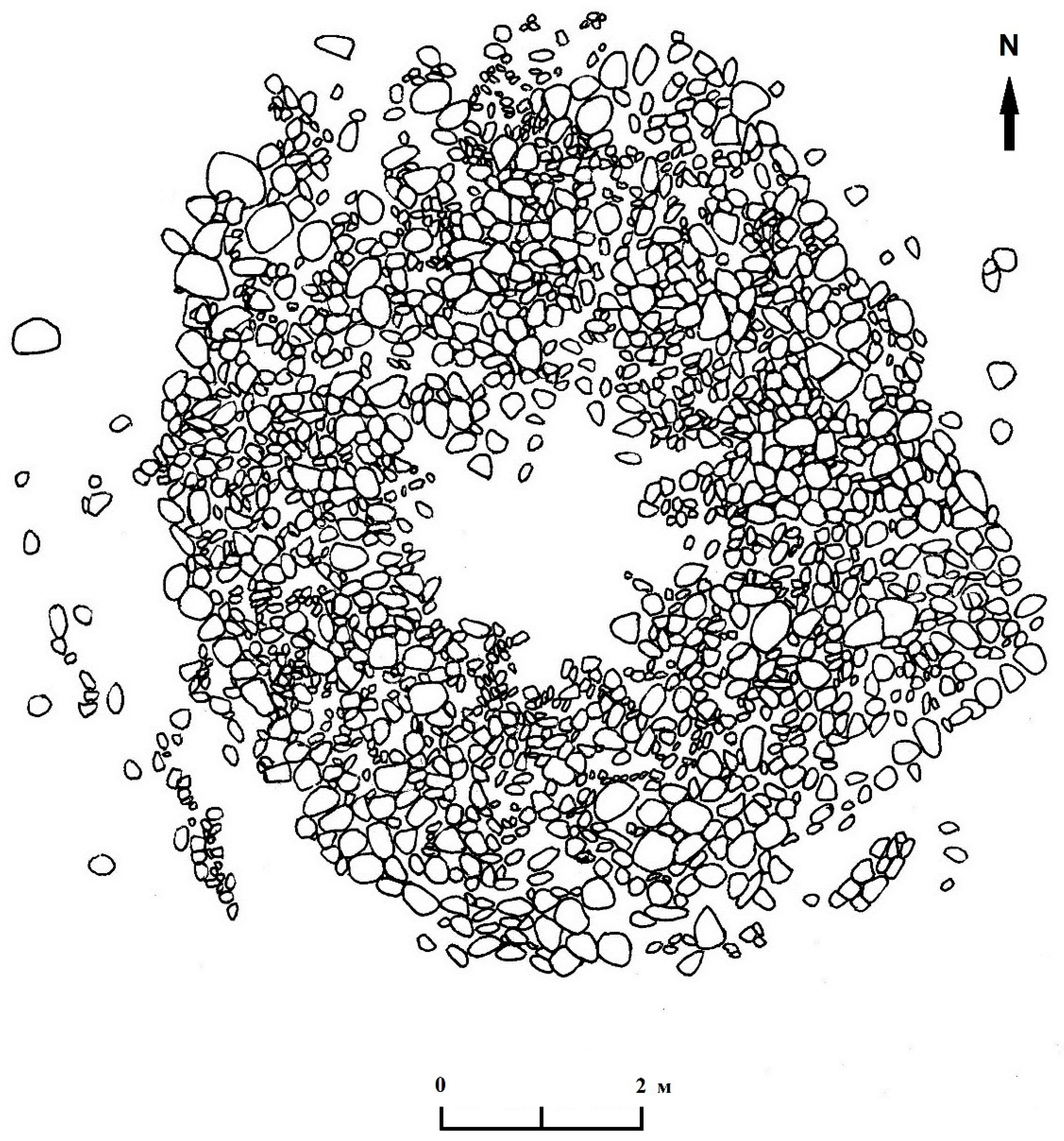
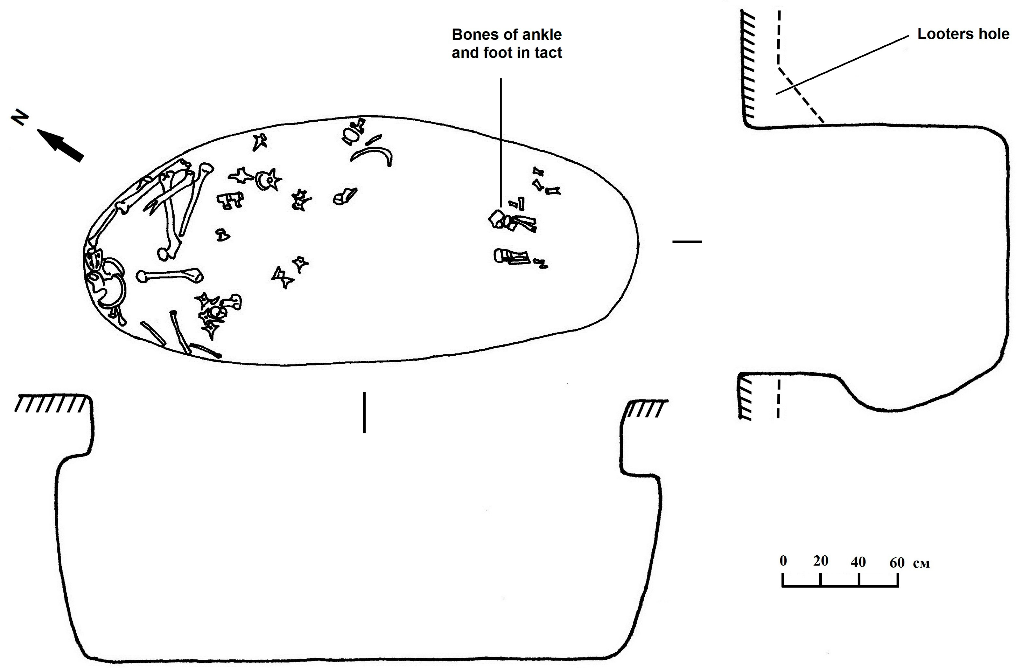
The architectural construction of this mound consists of both mounded earth and three layers of stone cobbles that form a square (see Figure 8). The corners of the square kurgan are oriented by cardinal directions, with slight deviation. In the center of the burial mound, there is a noticeable depression, about 0.25 m deep and is the result of a looter’s pit. The dimensions of the mound are 7.1 m x 6.8 m, with a height is 0.7 m from the present ground surface.
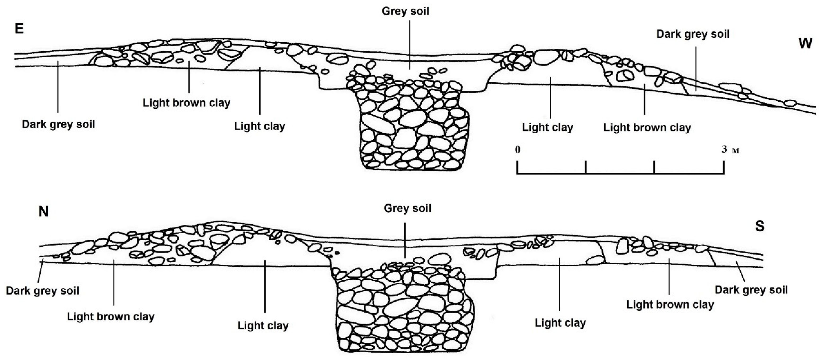
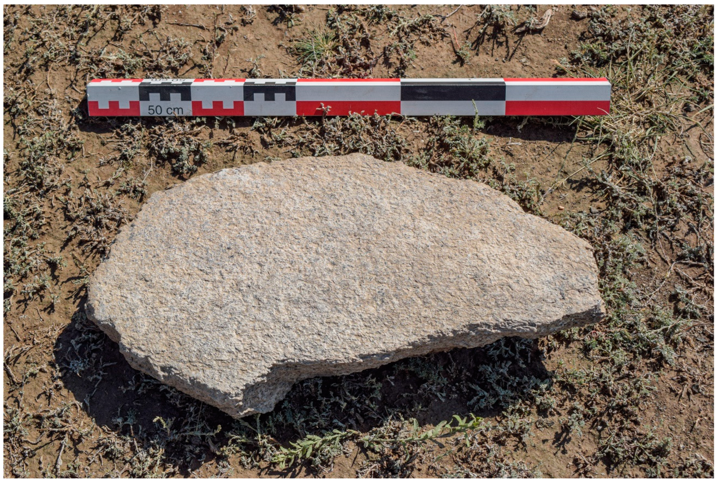
After removing the topsoil, we exposed a cover of small to large size river cobbles across the entire mound. Where the robber’s pit was found in the center, this area has no stones. Cross-trenches placed in a north-south and east-west direction are shown in Figure 9: Kurgan 1 profiles. There are two to three layers of stones; the bottom layer forms the borders of the mound itself, which has been built on a prepared yellow clay floor. The largest stones are usually found at the perimeter of the square mound. While cleaning the upper layer of stones, a fragment of a small grinding stone was found.
At the base of the mound is yellow-packed clay, a prepared surface upon which the layers of stone lie. In the area of the burial pit, a low, wide enclosure of light yellow clay encloses the burial shaft and pit; parts of this clay enclosure wall have been destroyed by the looter’s pit. Light-brown clay is found on the outside of the yellow clay enclosure wall. The stone layers form the cap of the kurgan. Later we also discovered that the same light yellow-packed clay along the sides of the chamber of the pit (see Figure 10.)
When the central part of the kurgan mound was excavated, the square outline of the robber’s pit was visible just below the packed yellow platform. The robber’s pit is rectangular in shape, and measures 2.6 by 2.3 m. After removing 20 cm of soil in the robber’s pit, an oval-shaped cluster of stones was uncovered; this oval pit is oriented in a northwest-southeast direction. This oval-shaped pit measures 2.75 by 1.4 m and outlines the original burial chamber (Figure 10). The looters found the original burial chamber and pit, then after finding the skeleton and robbing the contents of the grave, filled the grave shaft with stones. Almost the entire burial pit or shaft was filled with medium-sized and large stones.
At a depth of 20 cm below the original clay platform, a small fragment of a pottery vessel made of dark-red clay was found. Then at 35 cm below the platform in the southeastern part of the pit, a large fragment of another grinding stone was discovered (see Figure 11).
Fragments and pieces of human and domesticated animal bones, as well as pieces of wooden sticks (up to 20-25 cm long and 3-4 cm in diameter), were found among the stones and soil at a depth of 55 cm below the prepared clay platform. The wooden logs or sticks were found in the southeastern part of the burial pit. Bones and wooden fragments also were found at the bottom of the burial pit at a depth of 1.35 m from the prepared clay surface. At a depth of 1.1 m from the platform level, a heavily corroded fragment of iron was found in the center of the pit. This flat iron piece appears to be part of a knife blade.
Most of the human skeletal remains, disturbed by the robbers, were in a jumbled pile in the northwest part of the pit (including a severely damaged human skull). Many pieces of vertebrae, ribs, and unidentifiable fragments have also been scattered in the center of the burial pit. Only the skeletal remains of both the right and left feet and ankles of the human skeleton have been found in situ in the southeastern part of the burial pit (Figure 10). The human skeleton was originally laid out in a supine position, with the head to the northwest. We also took flotation samples from this southeastern part because this area of the burial chamber appeared to be untouched by the looters.
The burial pit has the shape of a podboi (пoдбoй). The podboi type of burial pit, common in Eurasia, is often referred to as a stepped burial pit, where attached to the main grave shaft is a side chamber where the skeleton is placed. The podboi is such that along the length of the northwest wall of the burial shaft, there is a widened chamber or concave wall dug 20 to 25 cm into the pit wall. In addition, the pit was also originally widened about 20 cm along the side of the shorter wall of the grave shaft (see Figure 10). Thus the entrance to the burial chamber is noticeably constricted, while the chamber at the bottom is larger in size. The human skeleton was originally laid out in the center of this burial chamber.
The identification of domesticated animal remains in the burial pit belong to several animals (see Table 3). These faunal remains indicate a ritual meal consisting of:
  • the teeth of a horse
  • the sheep/goat skull and the legs with the shoulder part
  • leg and chest part of cattle placed with the deceased, and cow tooth
Similar-looking square stone burial mounds are concentrated in the area around Lake Issyk-Kul, especially in the southeast region. However, mounds of the same type are known in the Inner Tian Shan and in Semirech’ye. Such mounds were first excavated in the 1950s by the Soviet archaeologist L.P. Zyablin [53] on the northern coast of Issyk-Kul. However, since they did not yield material items that could be dated easily, he attributed them to a fairly wide chronological period - from the 8th to the 13th centuries [53].
Later, in the early 2000s, square mounds were researched by K.S. Tabaldiev. He dated them using the square mounds and their burials using radiometric dating to the 2nd-3rd centuries CE. These dates do not contradict the material culture objects found in these mounds [54]. According to the radiometric dates taken from grave materials (a seed found in flotation) and charcoal from the burnt logs or branches found on the floor of the burial, this is a Turkic period grave dated between cal 660 and 991 CE, a later period than the square burial mounds studied by Tabaldiez [54]. Of considerable interest is the charred wheat grain (Triticum aestivum) found in the flotation sample that dates to 882-991 cal. CE. So that the ritual meals consisting of horse, cattle, and sheep/goats could also have included wheat and barley as reported from the flotation samples.

3.1.2. Excavations at EJS1.

This Iron Age site dating from 22 to 536 CE is identified as a Wusun period settlement. The block excavation is located on a downslope of 15 percent. The slope faces the southwest, therefore it has good sun exposure. The deposits consisted of light red sand with deposits of gravel and light buff-colored clay. In Grid Unit A-3, Feature 1, a small ashpit was uncovered. Feature 1 is 50 cm (East-West) X 22 cm (North-South) and was found about 25 cm from the present ground surface. No artifacts were recovered from the excavations. This feature is most likely part of an ethnographic period of occupation. The Iron Age deposits are between 1 and 1.5 meters below the present ground surface.
Six profiles were cleaned along the erosional cut to the south of the test excavations. These test excavations ranged from 1.5 m to 2 m. in depth. These profiles have archaeological features such as house pits, floor surfaces, and fire pits covered by sheet midden. Natural deposits of colluvium have created episodes of buried soils over the archaeological features. From these profiles there was a small collection of animal bones (sheep/goat, cattle and horse remains (see Table 4 and carbonized seeds found from flotation samples}.

3.1.3. Archaeobotanical Results

Lower Juuku Kurgan 1 (Turkic Period burial mound) Archaeobotanical Results

Five samples (volume – 31.5 l) from the burial mound were collected from two different contexts: two samples are from the southwest part of the grave pit and three samples are from the eastern part of the grave pit. In total, 14 carbonized seeds were recovered, where 7 seeds are cultivated and 7 seeds are wild. In addition to the carbonized seeds, charcoal, uncarbonized wood fragments, and uncarbonized chenopods (Chenopodium sp., n=40) were recovered and presumed to be indicative of bioturbation and modern inclusions. The total density of carbonized seeds (seeds/liter of sediment) was very low, only 0.44 seeds per liter, where 0.22 were domesticated and 0.22 were from wild plants. Domesticated crops consisted of barley (Hordeum vulgare, n=5) and free-threshing wheat (Triticum aestivum/turgidum, n=2) (Figure 12). Of this small sample, only one barley and one wheat grain could be measured (Table 5).
In total, 0.18 g of charcoal (> 2.0 mm in diameter) was recovered from the 5 samples, along with 10.07 g of uncarbonized wood fragments. Uncarbonized wood fragments predominantly came from two samples taken from the southwestern part of the grave pit. On the other hand, modern chenopods were recovered from samples taken from the eastern part of the grave pit. Wild plants were represented by Amaranthaceae (n=3), Trifolium sp. (n=1), Setaria cf. viridis (n=1), and two unidentified seeds.

Eastern Juuku Settlement 1 (Iron Age site) Archaeobotanical Results

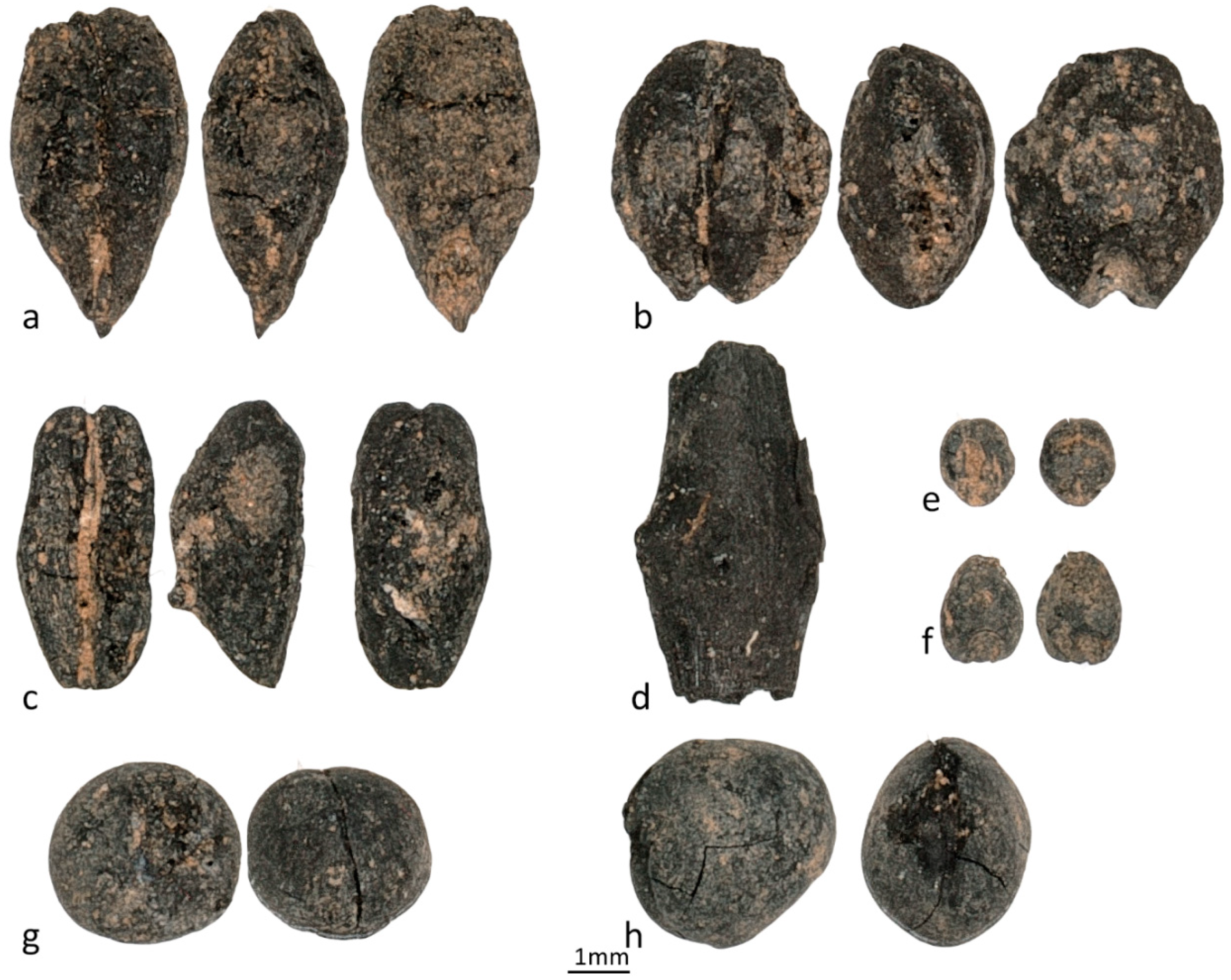
We floated 93 liters of sediment from the Eastern Juuku settlement and the archaeobotanical assemblage consisted of 114 carbonized seeds belonging to domesticated and wild plants. In addition to seeds, three culm nodes were recovered (Figure 13-d). In total, we report 21.1 g of charred wood fragments (>2.0mm), predominantly coming from Profiles 4 and 6. Four domesticated grains, barley (n=13), wheat (n=6), broomcorn millet (Panicum miliaceum, n= 4), and foxtail millet (Setaria italica, n=1) were recovered. Legumes were represented by a single pea (Pisum sativum, n=1) and a grass pea (Lathyrus sativus, n=1) (Figure 13g, 13h). Five samples were taken from 4 different contexts. There are two samples from Profile 4; however, one of the samples (FSEJS-2) was sterile, no carbonized/modern seeds or charcoal were recovered. Another sample (FSEJS1) from the same profile was the most informative sample. Cultivated species were recovered mainly from Profile 4 (about 20 m from the datum of EJS1) and Profile 6 (about 4 m from the datum of EJS1). Cultivated and wild plant remains were not found in the sample coming from Grid Unit A3 of the Block Excavation at EJS-1.
Wild herbaceous plants represent almost 77% of the assemblage. Many of the wild seeds cannot be identified to species, most of them were identified to genus or family level. The most numerous families were the amaranth family (Amaranthaceae, n = 31), the pinks family (Caryophyllaceae, n= 17), and the madder family (Rubiaceae, n=17). The amaranth family consists of chenopod seeds; while, the pinks family was mainly represented by cow cockles (Vaccaria cf. hispanica), the madder family consists only cleaver seeds (Galium sp.). The pinks family and the cleaver seeds may have been weeds found among field crops. In addition, seeds of wild plants such as Amaranthaceae, Asteraceae, Thlaspi arvense, cf. Silene spp., Convolvulus sp., Fabaceae, Medicago/Melilotus spp., Trifolium sp., Poaceae, wild Setaria sp., and Panicoid type were recovered in small numbers.

4. Discussion

At the three Iron Age sites (Tuzusai, Tseganka 8, and Taldy Bulak 2) in the Talgar region, the faunal record of NISP (Number of Species Identified) of sheep/goats of 59% to 70%, cattle 24% to 31%, horse (4% to 6%), and camel, ass, dog less that 1 percent. The plant remains from Tuzusai and Tseganka 8 include free-threshing wheat, hulled six-row barley, broomcorn millet, and grape pips [42]. Tuzusai also has foxtail millet, but Tseganka 8 does not. On the Talgar alluvial fan during the second half of the first millennium BCE, during the Middle to Late Saka phases, ancient people had an agropastoral economy of animal herding and cereal cultivation at about 725 to 1100 m asl. The highest percentage of grains come from wheat, then barley and finally the millets. Apple (Malus sp.) was also found in one sample at Tuzusai (FS-10, 2010 field season)) [42].
More than 3000 carbonized seeds were recovered from Tuzusai in 2008-2010 [4], yet no legumes were recovered. We mention this, because as small as the preliminary samples from EJS1 in the Juuku Valley, there was one pea found. Of particular interest is the contrast in grain size dimensions at Tuzusai 2009 (FS-11), where a contrast between a compact-eared wheat grain and a lax-eared is shown [4, Figure 7, p.73]. Although it is impossible on the basis of actual measurements of free-threshing wheat grain sizes (length, width, thickness) to show statistically the existence of different land races at Tuzusai (Spengler personal communication), it bears comment that there do appear to be examples of a compact ear wheat grains and a lax ear wheat grains since the MNI was only 448 wheat grains [4]. In Sweden experimental studies on growing Triticum aestivum (bread wheat) in different conditions have been done by a team of archaeobotanists [55]. These authors have demonstrated from their experimental plots that of these variables (site location and soil types, manuring, and plant density), the application of manures has caused increased wheat grain size.
The variability of wheat grain size at Tuzusai and the other Talgar Iron Age sites could be the results of adaptation to different environments, temperature and moisture conditions, plant density, and manuring. In future studies we are most interested in the effects of manuring on the cereals of the Talgar and Juuku region because this could be further indication of the interlocking dependency between herding systems and agriculture. After all, today sheep, goats and cattle are observed eating in stubble fields after harvest, thus manuring these stubble fields. Koster [56] has written about the articulation of cereal cultivation with animal herding in rural Greece in the 1970s and specifically documented the manuring of fields either through collection of sheep and goat manure to spread on fields, or from grazing the flocks on stubble fields after cereal harvests.
It is obvious from the faunal collections and archaeobotanical collections of carbonized seeds from the Talgar Iron Age that a mixed agricultural economy existed, not so different from what Ehlers and Kreutzmann [19] describe where wheat, barley, and broomcorn millet prevail along with domestic animals. Yet further laboratory analyses of the chemical or isotopic composition of the wheat seeds for elements such as nitrogen, phosphates or potassium may also test for manuring.
The Juuku assemblage is represented by two excavation areas dated by two periods: Wusun (50–300 CE) and Turkic (600–900 CE). The data coming from the Wusun period—Eastern Juuku settlement—is represented by several species of cereal grains and legumes; on the other hand, the data recovered from the burial mound at Lower Juuku is represented only by cereal grains, specifically barley and wheat. However, that data is not comparable, and we cannot speculate about differences in agriculture systems between the first half of the millennium CE at the Juuku valley since the sample of economic plants recovered in the burial mound are so small and could be associated with post-depositional processes (looting). This case study demonstrates the importance of direct radiocarbon dating of plant remains recovered from the burial mounds to avoid wrong assumptions about data interpretation and to estimate a period when the burial mound was looted. The presence of modern chenopods, mainly recovered in the eastern part of the grave pit, supports our hypothesis that some of the flotation samples may have been taken from fill sequences from disturbed contexts of the robber’s pit.
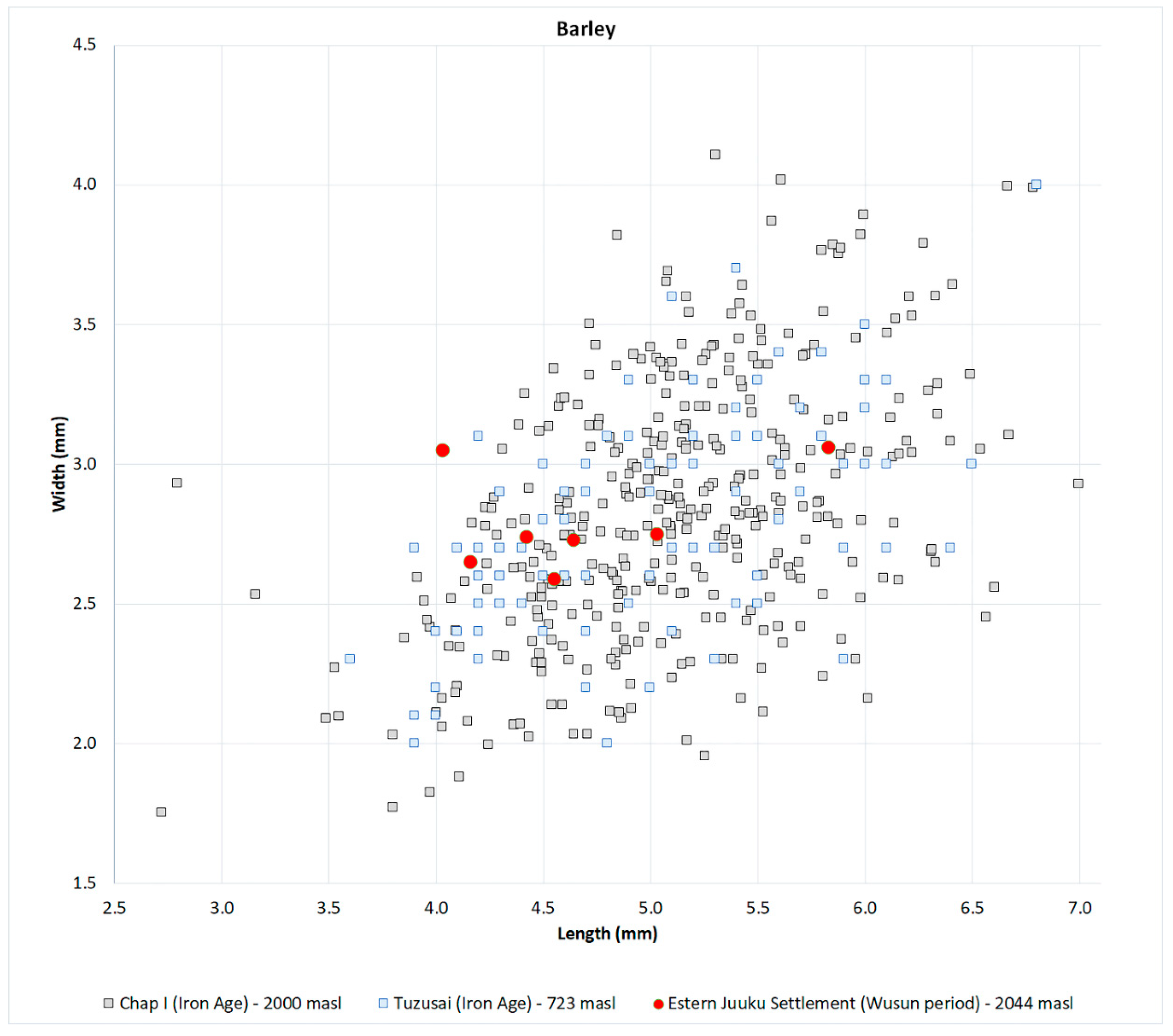
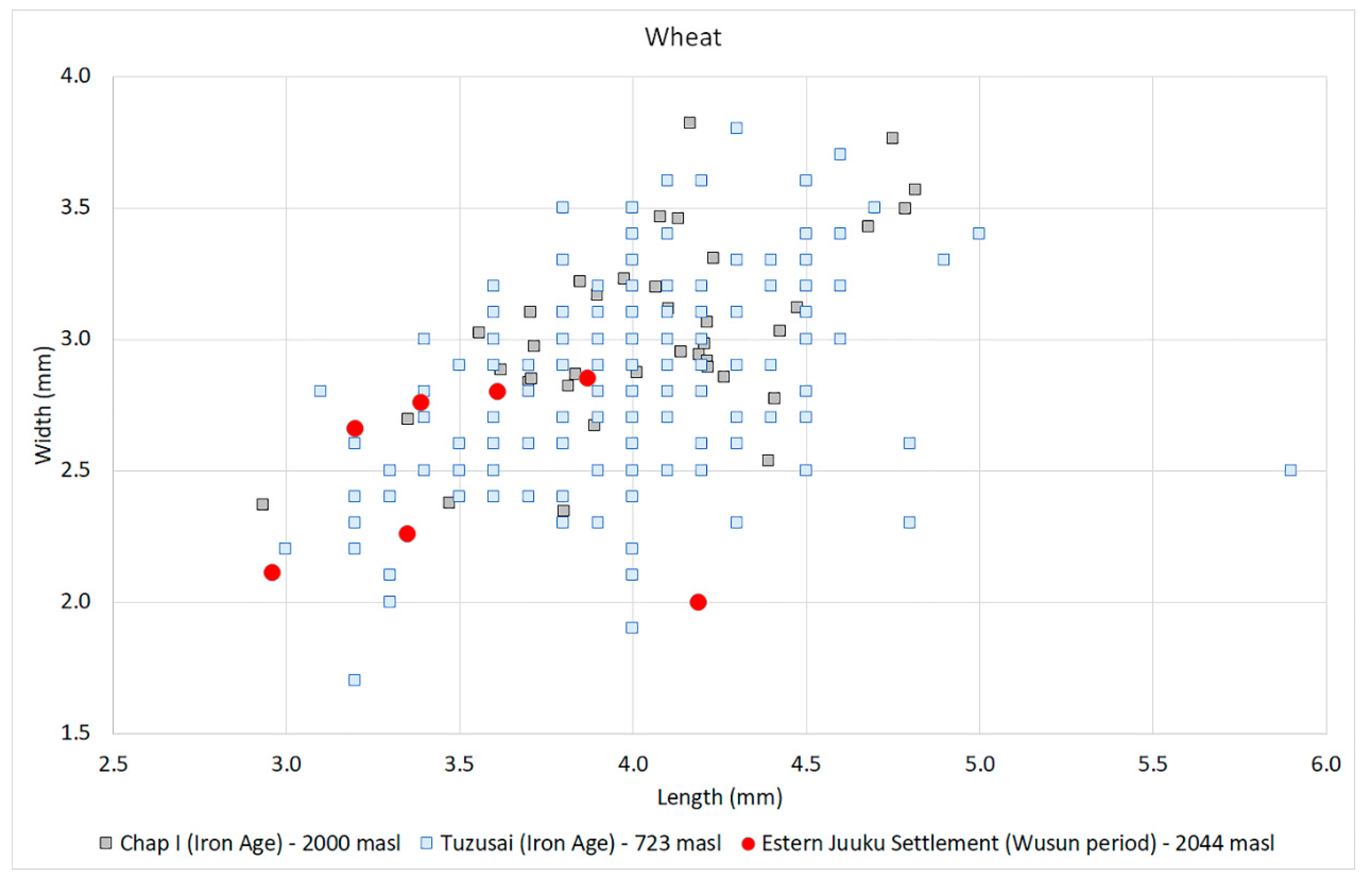
Even though this study is based on a small number of samples, our early results suggest that cereals and legumes were the main staple crops available to people living at the Eastern Juuku settlement in the first half of the first millennium CE, these data confirm our findings from the previous field season [14]. Both groups of plants (cereals and legumes) could have been part of the human diet, and possibly also fodder. The assemblage of the Juuku valley strengthens the realization that agriculture was an important part of the economy in the high-altitude valleys of Central Asia [7,57]. Contrasting Juuku data with Iron Age records retrieved from the Chap I site (1065 – 825 cal BCE) [7], Mukri (755 – 406 BCE), Tseganka (600 – 400 BCE), Tuzusai (410 BCE – 150 CE) [42] , and Begash- phase 3b (390 -50 BCE) [52], there are no significant alterations; however, it is important to note that agricultural expansion, to some extent, started in the first millennium BCE, but is also observed at the beginning of the first millennium CE at Juuku. Measurements of Juuku wheat and barley grains, in contrast to grain measurements from Iron Age sites specifically Tususai and Chap I, show no significant visual difference (Figure 14 and Figure 15) due to the small number of seeds measured at Juuku.
The study begins to fill the gap in our understanding of agricultural economies at the beginning of first millennium CE, with plant remains from Juuku. Even though we did not recover any newly introduced plants for the central part of the Tian Shan, we speculate that there may have been a crop-rotation system in operation in the Juuku valley at the beginning of the first millennium CE because, in addition to cereal grains, a couple of legumes were found. Legumes are rarely found at sites in central zone of Central Asia, but their presence in a small Juuku collection shows that they were used in the area around that time. While it requires further data to confirm, it is possible that these legumes represent a summer crop, along with millets, while wheat and barley are winter crops.
Yet if we return to the Stober and Herbers [49](p. 49) study on the Yasin Valley (2100 to 3500 m asl) in North Pakistan they describe upland villages where planting of barley in the early spring, followed by wheat and maize, and then in June by millets (this involves irrigation).
“Harvest time begins with the harvest of barley in the middle of June in the south; in the highest villages starts during the first half of August. In the summer settlements, barley has to be reaped from mid-August to the beginning of September, i.e. at a time when the wheat harvest is not yet competed in the villages. Maize and millet harvest will follow so that harvest time is generally finished by the end of September (cf. Figure 2).” [49] (p. 49).
We must always exercise caution when applying ethnographic analogies to ancient agricultural practice. Yet the strategies for labor management of fields, scheduling of cereal grains and the herding of livestock provide us with a way of modeling agricultural systems and land use in the past.
Based on previous [14] and current studies, we do not have any evidence of the viticulture adoption in the valley as has been proposed to have existed across the Talgar fan in the second half of the first millennium BCE [42]. Based on archaeobotanical data from Central Asia, we have observed that grape pips are mostly recovered from sites located below 830 masl; there are several exceptions, like medieval sites in Tajikistan at Panjakent (1022 masl) [58] and Kok-Tosh (1010 masl) [59], where grape was likely locally cultivated. While grape pips recovered in other southern parts of Central Asia like at Mugh (1362 masl) [60], Tashbulak (2200 masl) [61], and Bazar-Dara (3943 masl) [62] represent cash-crop exchange, the absence of viticulture in the Kochkor valley (Chap I) and in the Juuku valley (Eastern Juuku settlement) could be due to ecological constraints to the local growth.
The EJS1 settlement requires much more extensive excavation and then systematic archaeobotanical collection with larger bulk samples, such as those taken at the Talgar Iron Age sites and those taken at Chap I and II [4,6,7,8,42]. In addition, systematic faunal collections need to be undertaken to identify the herd species and other fauna at EJS1. In spite of this, the preliminary work shows great promise for future excavations. Recent test excavations in the Lower Juuku reaches (ca. 1800 to 1950 m asl) conducted by Franklin and Schmaus in 2023 also indicate Iron Age settlement along with the results of surveys conducted by Chang, Ivanov and Tourtellotte [13,14].
By comparing the agropastoral system at Talgar with agropastoralism in the Juuku Valley our future goals are to reconstruct a set of interlocking systems of economic subsistence of both cereal cultivation and animal herding along a vertical gradient. These preliminary studies (test and block excavations, radiometric dating, and archaeobotany in Juuku Valley are the first step towards designing a comprehensive study of changing land use strategies across vegetational and environmental gradients in high mountain areas. The geographic and ethnographic studies in north Pakistan put forth by Ehlers and Kreutzman [19]and their colleagues allow us to develop a set of hypotheses for further archaeological field research and laboratory studies. Ethnographic examples of Kazakh mobility and seasonal transhumance between mountain pastures in the summer and grazing lands in the plains in valleys in the summer are also instructive as well as village agropoastoralism [47,50].

5. Conclusions

The Talgar alluvial fan serves as an excellent comparative data base for examining agropastoralism during the first millennium BCE due to the excavation and survey efforts of the KAAE from 1994-2018. There continues to be material culture data, ceramic studies, and faunal and seed collections that may serve as the basis for future laboratory studies in chemical composition, isotopes, and even in experimental studies. The Juuku Valley is a natural laboratory for examining the middle elevational gradients (1600 to 2500 m asl) where ancient practices of agriculture and herding took place over a four-millennia time period. In the future we intend to extend our studies to establish changing patterns of sustainable land-use of upland areas. We also hope that our archaeological research into ancient patterns of land use might assist in providing guidelines for small-scale upland subsistence in rural mountain areas in Central Asia.

Author Contributions

Conceptualization, C.C., S.S.I., and R.N.S.; methodology, S.S.I., B.M.,P.A.T.; software, B.M.; validation, C.C., S.S.I. and R.N.S.; formal analysis, B.M.,R.N.S.; investigation, C.C., P.A.T., S.S.I.; resources, R.N.S.; data curation, C.C., B.M.; writing—original draft preparation, C.C..; writing—review and editing, S.S.I, B.M.,R.N.S.; visualization, P.A.T.,B.M.; supervision, C.C.,R.N.S.; project administration,S.S.I.; funding acquisition, R.N.S. All authors have read and agreed to the published version of the manuscript.

Funding

This research was funded by European Research Council Starting Grant 851102 for archaeobotanical research, Principal Investigator: R.N.S.

Data Availability Statement

The fieldwork data and the curation of artifacts is archived by Sergei S. Ivanov at the Kyrgyz National University, Department of International Relations and Oriental Studies (Bishkek, Kyrgyzstan). The archaeobotanical data is archived at the Max Planck Institute of Geoanthropology (Jena, Germany), Robert N. Spengler III, Director of the Archaeobotany Laboratory. Photographs and Landscape data are archived in the USA (Perry A, Tourtellotte) and in the Republic of Kyrgyzstan (Sergei S. Ivanov).

Acknowledgments

We wish to acknowledge Kathryn J. Franklin, Department of Archaeology and Medieval Studies, University of London (Birkbeck College) for her participation in 2022 field season and Tekla Schmaus, Department of Anthropology, University of Pittsburgh for her initial identifications of faunal remains at EJS-1 in 2022.

Conflicts of Interest

Authors declare that there are no conflicts of interest regarding the reported data, its analyses or interpretation; in the writing of the manuscript; or in the decision to publish the results. The funders had no role in the design of the study; in the collection, analyses, or interpretation of data; in the writing of the manuscript; or in the decision to publish the results.

References

  1. Kark, S. Ecotones and ecological gradients. In Ecological systems: selected entries from the encyclopedia of sustainability science and technology. Springer New York: New York, 2012, pp. 147-160.
  2. Turner, N. J.; Deur, D.; Mellott, C. R. “Up on the mountain:” ethnobotanical importance of montane sites In Pacific coastal North America. Journal of Ethnobiology 2011, Volume 31, 4-43. [CrossRef]
  3. Spengler III, R. N.; Frachetti, M. D.; Fritz, G. J. Ecotopes and herd foraging practices in the steppe/mountain ecotone of Central Asia during the Bronze and Iron Ages. Journal of Ethnobiology 2013, Volume 33, 125-147. [CrossRef]
  4. Spengler III, R. N.; Chang, C.; Tourtellotte, P. A. Agricultural Production in the Central Asian Mountains: Tuzusai, Kazakhstan (410-150 B.C.) Journal of Field Archaeology 2013, Volume 38, 68-84. [CrossRef]
  5. Motuzaitė Matuzevičiūtė, G.; Tabaldiev, K., Hermes,T.; Ananyevskaya, E.; Grikpedis, M.; Luneau, E.; Merkyte, I.; Rouse, L.M. High-altitude agro-pastoralism in the Kyrgyz Tien Shan: new excavations of the Chap farmstead (1065–825 cal b.c.). Journal of Field Archaeology 2020, Volume 45, 29-45. [CrossRef]
  6. Motuzaite Matuzeviciute, G.; Mir-Makhamad, B.; Spengler, R.N. Interpreting Diachronic Size Variation in Prehistoric Central Asian Cereal Grains. Front Ecol Evol 2021, Volume 9. [CrossRef]
  7. Motuzaite Matuzeviciute G.; Mir-Makhamad B.; Tabaldiev, K. First comprehensive archaeobotanical analysis of prehistoric agriculture in Kyrgyzstan. Veg Hist Archaeobot 2021. https://doi.org/https://doi.org/10.1007/s00334-021-00827-0.
  8. Motuzaite Matuzeviciute, G.; van Unen, M.; Karaliute, R.; Tabaldiev, K. The resilience of pioneer crops in the highlands of Central Asia: Archaeobotanical investigation at the Chap II site in Kyrgyzstan. Front. Ecol. Evol. 2022, 10:934340. [CrossRef]
  9. Chang, C. Rethinking Prehistoric Central Asia: Shepherds, Farmers, and Nomads. Routledge Press: Abingdon, UK. 2018.
  10. Spengler III, R.N.; Miller, A.V.; Schmaus, T.; Matuzevičiūtė, G.M.; Miller, B. K.; Wilkin, S., ... Boivin, N.. An imagined past? Nomadic narratives in Central Asian archaeology. Current Anthropology 2021, 62(3), 251-286.
  11. Frachetti, M.D. Multiregional emergence of mobile pastoralism and nonuniform institutional complexity across Eurasia. Current Anthropology 2012, 53(1), 2-38. [CrossRef]
  12. Rouse, L. M.; Dupuy, P. N. D.; Brite, E. B.The Agro-pastoralism debate in Central Eurasia: Arguments in favor of a nuanced perspective on socio-economy in archaeological context. Journal of Anthropological Archaeology, 2022,67, 101438. [CrossRef]
  13. Chang, C.; Ivanov, S.S.; Tourtellotte, P.A. Landscape and Settlement over 4 millennia on the South Side of Lake Issyk-Kul, Kyrgyzstan: Preliminary Results of Survey Research in 2019-2021. Land 2022, 11, 456. [CrossRef]
  14. Chang, C.; Ivanov, S.S.; Tourtellotte, P.A.; Spengler III, R.N.; Mir-Makhamad, B.; Kramar, D. Ancient Agricultural and Pastoral Landscapes on the South Side of Lak Issyk-Kul: Long-Term Diachronic Analysis of Changing Patterns of Land Use, Climate Change, and Ritual Use in the Juuku and Kizil Suu Valleys. Land 2022, 11, 902. [CrossRef]
  15. Odum, E.P.; Barrett, G.W. Fundamentals of ecology. Saunders: Philadelphia.1971.
  16. Lane, K. Through the looking glass: re-assessing the role of agro-pastoralism in the north-central Andean highlands. World Archaeology, 2006, 38, 493-510. [CrossRef]
  17. Maezumi, S.Y.; Elliott, S.; Robinson, M.; Betancourt, C.J.; Gregorio de Souza, J.; Alves, D.; ... & Iriarte, J. Legacies of Indigenous land use and cultural burning in the Bolivian Amazon rainforest ecotone. Philosophical Transactions of the Royal Society B, 2022, 377(1849), 20200499. [CrossRef]
  18. Novenko, E.Y.; Tsyganov, A.N.; Rudenko, O.V.; Volkova, E.V.; Zuyganova, I.S.; Babeshko, K.V.;... & Mazei, Y.A. Mid-and late-Holocene vegetation history, climate and human impact in the forest-steppe ecotone of European Russia: new data and a regional synthesis. Biodiversity and Conservation, 2016, 25, 2453-2472. [CrossRef]
  19. Ehlers, E; Kreutzmann, H. (Eds). High Mountain Pastoralism in Northern Pakistan. Franz Steiner Verlarg Stuttgart: Stuttgart, Germany. 1990.
  20. Chen, F.; Yuan, Y.; Trouet,V.; Büntgen, U.; Esper, J.; Chen, F.; ... Zhang, H. Ecological and societal effects of Central Asian streamflow variation over the past eight centuries. npj Climate and Atmospheric Science, 2022, 5, 27. [CrossRef]
  21. Stevens, C. J.; Murphy, C,; Roberts, R.; Lucas, L.; Silva, F.; Fuller, D. Between China and South Asia: A Middle Asian corridor of crop dispersal and agricultural innovation in the Bronze Age. The Holocene, 2016, 26(10): 1541-1555. [CrossRef]
  22. Kuz’mina, E. The Prehistory of the Silk Road: Encounters with Asia (Mair,V.H.; Trans.), University of Pennsylvania Press: Philadelphia USA. 2008.
  23. Frachetti, M.D.; Smith, C.E.; Traub, C. M.; Williams, T. Nomadic ecology shaped the highland geography of Asia’s Silk Roads. Nature, 2017, 543(7644), 193-198. [CrossRef]
  24. Leroy, S.A.G.; Ricketts, R.D.; Rasmussen, K.A. Climatic and limnological changes 12,750 to 3600 years ago in the Issyk-Kul catchment, Tien Shan, based on palynology and stable isotopes. Quaternary Science Reviews, 2021, 259, 106897. [CrossRef]
  25. Shnaider, S.; Zhilich,S.V.; Zotkina, L.V.; Boxleitner, K.A.; Taylor, W.T.T.; Sayfullaev, N.; Koval, V.V.; Baranova, S.V.; Chernonosov, A.A.; Kutnyakova, L.A.; Tonasso-Calviere, L.; Orlando,L.; Spengler III, R.N. Occupation of highland Central Asia: New evidence from Kurteke rockshelter, Eastern Pamir. Archaeological Research in Asia 2023, 34, 100443.
  26. Taylor, W.T.T.; Pruvost, M.; Posth, C.; Rendu, W.; Krajcarz, M.T.; Abdykanova, A., Brancaleoni, G.; Spengler, R.; Hermes, T.; Schiavinato, S.; Hodgins, G.; Stahl, R.; Min, J.; Alisherkyzy, S.; Fedorowicz, S.; Orlando, L.; Douka, K.; Krivoshapkin, A.; Jeong, C.; Warinner, C.; Shnaider, S. Evidence for early dispersal of domestic sheep into Central Asia. Nat. Hum. Behav.2021, 5, 1169–1179. [CrossRef]
  27. Zhou, X.; Yu, J.; Shen, H.; Zhao, K.; Junyi, G.; Bao, Y.; Liu, J.; Yang, Q.; Spengler III, R.N.; Li, X. Redating the Trans-Eurasian crop exchange: 5200-year-old cereal grains from the eastern Altai Mountains. Nature Plants 2020, 6, 78–87.
  28. Tang, L.; Lu, H.; Song, J.; Wangdue, S.; Chen, X.; Zhang, Z.; Liu, X.; Boivin, N.; Spengler III, R.N. The transition to a barley-dominant cultivation system in Tibet: first millennium BC archaeobotanical evidence from Bangga. J. Anthropol. Archaeol.2021, 61, 101242.
  29. Spengler, R.N.; Tang, L.;Nayak, A.; Boivin, N.; Olivieri, L.M. The southern central Asian mountains as an ancient agricultural mixing zone: new archaeobotanical data from Barikot in the swat valley of Pakistan. Veg. Hist. Archaeobotany 2021, 30, 463–476. [CrossRef]
  30. Toonen,W.H.; Macklin, M.G.; Dawkes, G.; Durcan, J.A.; Leman, M.; Nikolayev,Y.; Yegorov, A. A hydromorphic reevaluation of the forgotten river civilizations of Central Asia. Proceedings of the National Academy of Sciences, 2020, 117(52), 32982-32988. [CrossRef]
  31. Kradin, N.N. Nomadism, evolution and world-systems: pastoral societies in theories of historical development. Journal of World-Systems Research, 2002,368-388. [CrossRef]
  32. Ball,W. The Eurasian Steppe: People, Movement, Ideas. Edinburgh University Press: Edinburgh, UK. 2021.
  33. Beckwith, C.I. The Scythian Empire: Central Eurasia and the Birth of the Classical Age from Persia to China. Princeton University Press: Princeton, USA.2022.
  34. Koryakova, L.; Epimakhov, A. V. The Urals and western Siberia in the Bronze and Iron ages. Cambridge University Press: Cambridge, UK. 2014.
  35. MotuzaitėMatuzevičiūtė, G.; Preece, R.C.; Wang,S.; Colominas, l.; Ohnuma, K.; S. Kume, S.; Abdykanova, A.; Jones, M.K. Ecology and subsistence at the Mesolithic and Bronze Age site of Aigyrzhal-2, Naryn valley, Kyrgyzstan. Quaternary International 2015, 437, 35–49. [CrossRef]
  36. Miller, N.F.; Spengler III, R.N.; Frachetti, M. Millet cultivation across Eurasia: origins, spread, and the influence of seasonal climate. The Holocene 2016, 26, 1566–1575.
  37. Chang, C.; Beardmore, R. The tale of a mud brick: lessons from Tuzusai and de-assembling an Iron Age site on the Talgar alluvial fan in southeastern Kazakhstan. In Incomplete archaeologies: assembling knowledge in the past and present; Eds.: Bonney, E,M.; Franklin, K.J.; Johnson, J.A.: Oxbox Press: Oxford, UK, 2015, pp. 84–97.
  38. Chang, C.; Benecke, N.; Grigoriev, F.P.; Rosen, A.M.; Tourtellotte, P.A. Iron Age society and chronology in south-east Kazakhstan. Antiquity 2003,77(296), 298–312. [CrossRef]
  39. Chang, C.; Tourtellotte, P.; Baipakov, K.M.; Grigoriev, F.P. The evolution of steppe communities from Bronze Age through Medieval periods in Southeastern Kazakhstan (Zhetysu). Sweet Briar College: Sweet Briar, VA, USA. 2002.
  40. Spengler III, R.N. Agriculture in the Central Asian Bronze Age. Journal of World Prehistory 2015, 28(3), 215–253. [CrossRef]
  41. Spengler III, R.N.; Ryabogina, N.; Tarasov,P.; Wagner, M. The spread of agriculture into Northern Asia. The Holocene 2016, 26, 1527–1540.
  42. Spengler III, R.N.; Miller, N.F.; Neef,R.; Tourtellotte, P.A.; Chang,C. Linking agriculture and exchange to social developments of the Central Asian Iron Age. Journal of Anthropological Archaeology 2017, 48, 295–308. [CrossRef]
  43. Baipakov, K.M. The city and steppe in antiquity: sedentism and agriculture in the Saka and Wusun of Semirech’ye.Izvestia 2008,1, 3–25. [In Russian.].
  44. Akishev,K.A. Origins of sedentism and farming of the ancient Wusun of Semirech’ye. In About the ancient cultures of Kazakhstan. Pp. 69–77. Nauka: Alma-Ata, KZ, 1970. [In Russian.].
  45. Tabaldiev, Kubatbek Sh. Drevniye Panyatniki Tenir-Too.[Ancient Monuments of Tenir-Too], Doctor of Science Dissertation]. OKNGN, Universitet Tsentral’noi Asii: Bishkek, Kyrgyzstan, 2022 [In Russian].
  46. Khazanov, A.N. Nomads and the outside world (Second edition). University of Wisconsin Press: Madison, WI, USA. 1994.
  47. Ferret, C. Mobile pastoralism a century apart: continuity and change in south-eastern Kazakhstan, 1910 and 2012. Central Asian Survey 2018, 37(4), 503-525. [CrossRef]
  48. Mel’nik, G.A. Ed. Preobrazhennia atep’. Sel’akoe khoziastvo Kazakhstana na 50-let Sovetskoi vlasti (1917-1967 gg.) [Transformation of the Steppe. Agriculture in Kazakhstan during 50 years of Soviet Power (1917-1967)]. Kainar: Alma-Ata, KZ. 1967.
  49. Stober, G.; H.Herbers. Animal husbandry in domestic economies: organization, legal aspects, and present changes of combined mountain agriculture in Yasin. In High Mountain Pastoralism in Northern Pakistan, Eds.: Ehlers,E.; Kreutzmann, H. Franz Steiner Verlag Stuttgart: Stuttgart, Germany, 2000, pp. 37-58.
  50. Hauck, M.; Artykbaeva, G.T.; Zozulya, T. N.; Dulamsuren, C. Pastoral livestock husbandry and rural livelihoods in the forest-steppe of east Kazakhstan. Journal of Arid Environments, 2016, 133, 102-111. [CrossRef]
  51. Benecke, N. Iron Age economy of the Inner Asian steppe: A bioarchaeological perspective from the Talgar region of the Ili river valley (southeastern Kazakhstan). Eurasia Antiqua 2003, 9. 63-85.
  52. Spengler III, R.N. Botanical resource use in the Bronze and Iron Age of the Central Eurasian mountain/steppe interface: decision making in multiresource pastoral economies. PhD dissertation. Washington University in St. Louis, Anthropology Department: St. Louis, Missouri USA. 2013.
  53. Zyablin, L.P. Srednevekovye kurgany na Issyk-Kule. Trudy Kirgizskoi kompleksnoi arkheologo-etnograficheskoi ekspeditsii. (Medieval kurgans on Issyk-Kul lake. Proceedings of Kyrgyz complex archaeological and ethnological expedition) 1959, Volume 2,139-154. Izd-vo AN SSR: Moscow, USSR.
  54. Tabaldiev, K.Sh., Akmatov, K., & Ashyk, A. Pogrebalnye pamyatniki khunnskogo vremeni mezhdorovykh dolin Tenir-Too (Tyan-Shan). Evraziiskaya stepnaya tsivilizatsiya: chelovek i istoriko-kulturnaya sreda (Funeral monuments of Xiongnu perion in mountain valleys of Tien Shan. Steppe civilization of Eurasia: human and History and cultural area) 2022, 106-113. Almaty-Turkestan.
  55. Larsson, M.; Bergman,J. Experimental approach to evaluate the effect of growing conditions on cereal grain size and its relevance for interpreting archaeological cereal grain assemblages. Journal of Archaeological Sciences 2021, 152: 105752. [CrossRef]
  56. Koster, H.A. The Ecology of Pastoralisn in Relation to Changing Patterns of Land Use in the Northeast Peloponnese. Ph.D. dissertation, 1977. University of Pennsylvania, Anthropology Department: Philadelphia, PA. USA.
  57. Spengler III, R.N.; Frachetti, M.; Doumani, P. et al. Early agriculture and crop transmission among Bronze Age mobile pastoralists of Central Eurasia. Proc R Soc B Biol Sci 2014, 281:20133382. [CrossRef]
  58. Mir-Makhamad, B.; Parshuto, V.; Lurje, P. et al. Земледелие в бассейне среднегo Зеравшана: предварительный oтчёт oб археoбoтанических исследoваниях Пенджикента (Agriculture in the Middle Zarafshan Basin: A Preliminary Paleoethno botanical Study from the Sogdian City of Panjakent. ). In Материалы Пенджикентскoй Археoлoгическoй Экспедиции. Выпуск XXV 2022, 65-74.The State Hermitage Museum: Saint Petersburg, Russia.
  59. Mir-Makhamad, B.; Lurje, P.; Parshuto, V.; et al. Agriculture along the Middle Zarafshan River during the first millennium AD: A multi-site archaeobotanical analysis. PLoS One forthcoming.
  60. Danilevsky, V.V.; Kokonov, V.N.; Nikitin, V.A. Исследoвание растительных oстаткoв из раскoпoк сoгдийскoгo замка VIII века на гoре Муг в Таджикистане (A Study of the Plant Remains Excavated from the VIII century Settlement of Mugh in Tajikistan). In: Растительнoсть Таджикистана и ее oсвoение (Vegetation of Tajikistan and Human Interaction). Тр. Таджикистан базы АН СССР (Tajikistan Base of Science of the SSSR) 1940, 479-505. Dushanbe.
  61. Spengler III, R.N.; Maksudov, F.; Bullion, E.; et al (2018) Arboreal crops on the medieval Silk Road: Archaeobotanical studies at Tashbulak. PLoS One 2018, 13, 1–16. [CrossRef]
  62. Bubnova M. Вoпрoсу o Земледелии На Западнoм Памире В IX-XI вв (Regarding the question of agriculture in the Western Pamirs from the IX-XI centuries). In Прoшлoе Средней Азии: Археoлoгия, Нумизматика и Эпиграика, Этнoграния (Past Central Asia: Numismatics Archaeology and Ethnography Epigraphy) 1987, 59-66. Дoниш (Donish): Dushanbe.
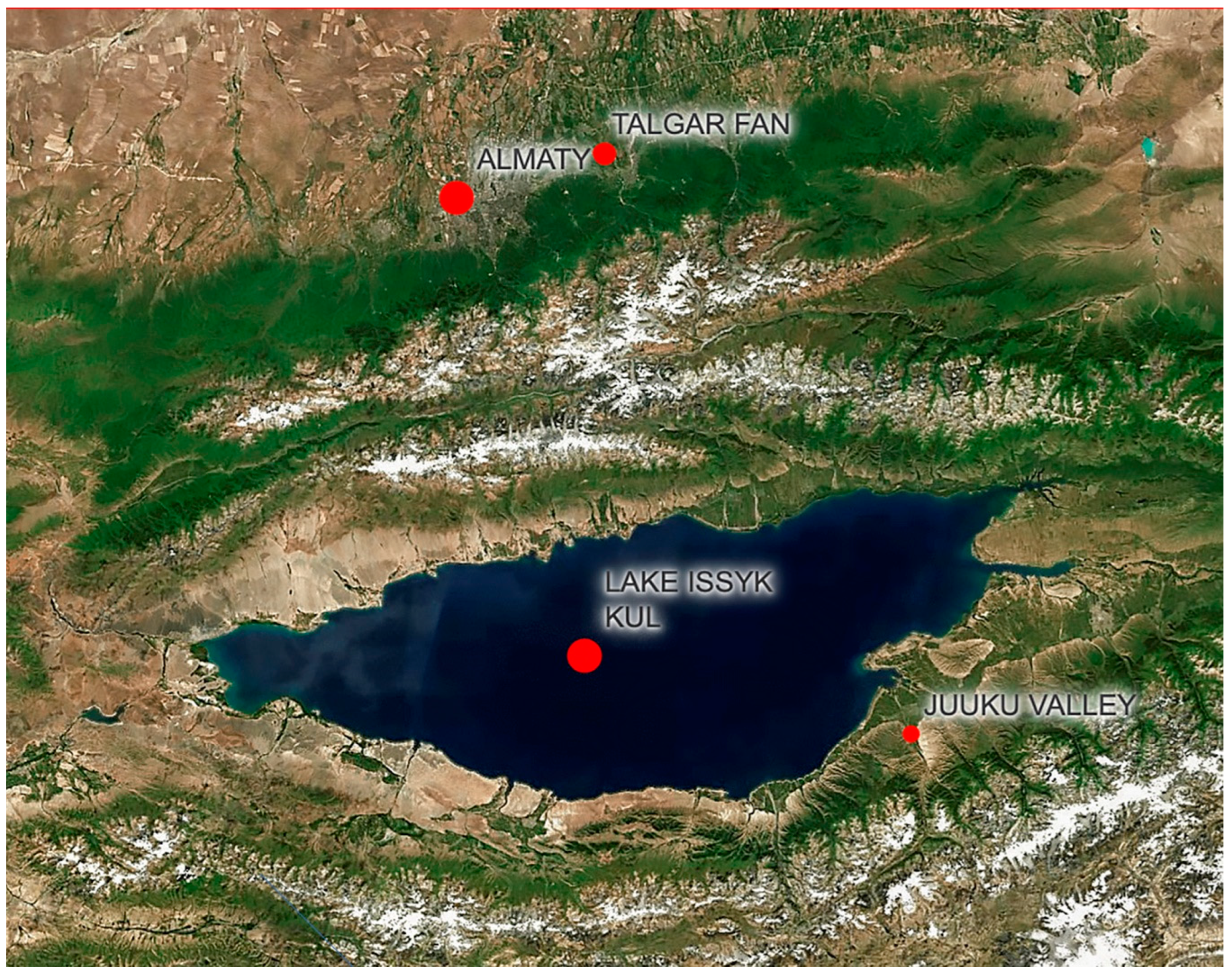
Figure 1. Locator Map showing the Juuku Valley in Northeast Kyrgyzstan and the Talgar Fan in Southeastern Kazakhstan.
Preprints 73724 g001
Figure 2. The model of vertical zonation and farming and herding strategies in high mountain areas [19] (p.10).
Preprints 73724 g002
Figure 3. A Google Earth image of the Juuku Valley showing the location of EJS1 (Iron Age settlement in the Eastern Juuku Branch and the location of LJK1 (Turkic period kurgan) in Lower Juuku valley.
Preprints 73724 g003
Figure 4. Oblique View of Lower Juuku Kurgan 1, view to the north.
Preprints 73724 g004
Figure 5. EJS1. Excavation and Profile Cleaning, July 2022.
Preprints 73724 g005
Figure 6. Basira Mir-Makhamad and Malike Primidova taking flotation samples from Profile 6.
Preprints 73724 g006
Figure 7. Taking Flotation Samples from Profile 4: Robert Spengler, Sergei Ivanov, and Claudia Chang in background.
Preprints 73724 g007
Figure 8. A Plan Drawing of Lower Juuku Kurgan 1.
Preprints 73724 g008
Figure 9. Lower Juuku Kurgan 1: East-West and North-South profiles.
Preprints 73724 g009
Figure 10. Lower Juuku Kurgan 1: View of Podboi, Grave Shaft and Burial Chamber.
Preprints 73724 g010
Figure 11. Photograph of Grinding Stone from Lower Juuku Kurgan 1 surface.
Preprints 73724 g011
Figure 12. Cultivated plants the burial mound in Juuku. a – barley and b – wheat.
Preprints 73724 g012
Figure 13. a – hulled barley, b – highly compact barley, c – wheat, d – culm node, e – foxtail millet, f – broomcorn millet, g – pea, and h – cf. grass pea.
Preprints 73724 g013
Figure 14. A scatter plot based on barley grain measurements from Chap I [6], Tuzusai [52], and Eastern Juuku Settlement (2019 and 2022 seasons).
Preprints 73724 g014
Figure 15. A scatter plot based on wheat grain measurements from Chap I 2021a) [6], Tuzusai [52], and Eastern Juuku Settlement (2019 and 2022 seasons).
Preprints 73724 g015
Table 1. Time Periods, Phase Designations, and Dates used for the Juuku Valley.
Time Period Phase Designation Dates
Late Bronze Age 2000 BCE–900 BCE
Final Bronze 1100 BCE–800 BCE
Iron Age 800 BCE–550 CE
Saka 800 BCE–260 BCE
Wusun 140 BCE–437 CE
Kenkol (only in Tian Shan) 200 CE–550 CE
Medieval Period 500 CE–1500 CE
Turkic Period 552 CE–900 CE
Qarakhanid 942 CE–1228 CE
Early Kirghiz 1500 CE–1700 CE
Kirghiz Ethnographic Period 1700 CE–Present
Soviet Period 1917–1991
Post-Soviet, Kyrgyz Nation 1991–
Table 2. Radiocarbon results from carbonized material found at two Settlements and one Burial Kurgan recovered from the Juuku Valley.
# Lab ID Material/Pretreat d13C o/oo
IRMS
Conventional Dates (BP) Calibrated Dates at 95.4% (AD) Settlement
1 OS-165284 Wheat grain --- 1850+/-15 130-237 Site-EJS1
Profile 1
2 OS-165285 Barley grain --- 1680+/-15 376-532 Site-EJS1
Profile 1
3 Beta-603779 (charred material)
acid/alkali/acid
-22.7 1930+/-30 22-206 Site-EJS1
Profile 1
4 OS-
170789
Barley (Hordeum vulgare) --- 1860+/-25 125-237 Site-EJS1
Profile 4
5 OS-
170790
Barley (Hordeum vulgare) --- 1880+/-20 88-223 Site-EJS1
Profile 6
6 OS-
170788
Wheat (Triticum aestivum) --- 1130+/-20 882-991 LJKurgan 1.
Eastern part of intact wall
7 Beta-
654154
(charred material) -23.7 1300+/-30 660-774 LJKurgan 1
South part of burial pit
8 Beta-603780 (charred material)
acid/alkali/acid
-25.3 1020+/-30 978-1151 Site-EJS2
9 Beta-603781 (charred material)
acid/alkali/acid
-26.5 110+/-30 1682-1932 Site-LJS1
Table 3. Lower Juuku Kurgan 1: Preliminary Identification of Animal and Human Remains in the Grave Shaft and Burial Chamber.
Depth from Yellow Clay Surface Horse remains Sheep/Goat remains Cattle
remains
Unidentifiable fragments, animal Human remains
65 to 70 cm below surface Horse molar 2humerus fragments
1 tibia
1lateral malleolus
1 radius
5 skull fragments
10 fragments
1 long bone fragment
Unknown depth 1fragment radius/ulna
1 tibia
4 fragments of large animal long bone
8 fragments
2 vertebrae
7 fragments
Unknown depth 2fragments radius/ulna
5 animal bone fragments
1 calcine bone fragment
7 fragments human bone
150 cm below surface 1 incisor horse 1 molar
1 mandible
2thoracic vertebrae
1 calcaneus
1scapula fragment
4vertebrae epiphyses
1 premolar
4tibia fragments 88 fragments 1 human
Fibula
1 proximal phalange
14 fragments
Table 4. Eastern Juuku Settlement 1, Profile #4: Preliminary. Identification of Faunal Remains.
Horse remains Sheep/Goat remains Cattle
remains
Unidentifiable
remains
1 rib 1humerus fragment
1 molar
1 rib
1 radius
1tibia fragment
1 long bone
Table 5. Seed measurements from the burial mound in Juuku.
Total Whole Not measurable Length (mm) Width (mm) Thickness (mm)
Barley 5 1 4 4.46
2.82
2.4
Wheat 2 1 1 3.3
2.21
1.78
Table 6. Average of seed measurements of barley and wheat from the Eastern Juuku settlement.
Total Whole Not measurable Average length (mm) Average width (mm) Average thickness (mm)
Barley 13 4 9 4.61
2.88
1.69
Wheat 5 4 2 3.64
2.46
2.15
Table 7. Absolute number and density of cultivated crops and wild specimens from the Juuku valley.
Juuku-2022 Total seeds Domesticated Wild specimens
Phase Volume Absolute number Density Absolute number Density Absolute number Density
Lower Juuku Kurgan
(600 – 900 CE)
31.5 14 0.44 7 0.22 7 0.22
Eastern Juuku settlement
(88 – 237 CE)
93 114 1,22 26 0.28 88 0.94
Disclaimer/Publisher’s Note: The statements, opinions and data contained in all publications are solely those of the individual author(s) and contributor(s) and not of MDPI and/or the editor(s). MDPI and/or the editor(s) disclaim responsibility for any injury to people or property resulting from any ideas, methods, instructins or products referred to in the content.
Copyright: This open access article is published under a Creative Commons CC BY 4.0 license, which permit the free download, distribution, and reuse, provided that the author and preprint are cited in any reuse.
Prerpints.org logo

Preprints.org is a free preprint server supported by MDPI in Basel, Switzerland.

Subscribe

© 2024 MDPI (Basel, Switzerland) unless otherwise stated