Preprint
Article

Spatial Distribution and Driving Mechanisms of Rural Settlements in the Shiyang River Basin, Western China

Altmetrics

Downloads

116

Views

31

Comments

0

A peer-reviewed article of this preprint also exists.

Submitted:

18 June 2023

Posted:

19 June 2023

You are already at the latest version

Alerts
Abstract
In the context of the rural revitalization strategy, it is urgent to accurately grasp the spatial differentiation characteristics and influencing factors of rural settlements in underdeveloped arid inland river basins. Taking the Shiyang River Basin as an example, the rural settlements from 2000 to 2019 were obtained by visual interpretation using satellite remote sensing data and official statistical data. Following the logical of "state characteristics - evolutionary patterns - influence factors - layout optimization", the average nearest index, gravity-center migration model, spatial statistical analysis and other methods were used combine with GIS. The spatiotemporal pattern evolution characteristics of rural settlements in the past 20 years have been analyzed. The results revealed the following: 1) The distribution pattern of rural settlements in the study area is sheet-like and strip-shaped. The projects in the southeast are mostly distributed in a patchy pattern with high density, while the characteristics in the west and north are exactly opposite. The objects in the south are distributed in the alluvial area of rivers, while settlements in the north are located in the oasis area. 2) From 2000 to 2019, the scale of rural settlements in the Shiyang River Basin, where simultaneous occurrence of new-built and disappearing phenomena, shows an expansion trend that fast firstly and then slow. Spatially, rural settlements in the basin show a trend of clustering towards the southwest. 3) The distribution characteristics of rural settlements are close to water and roads, greatly influenced by urban-rural integration and ecological migration. The results will provide scientific basis for accelerating the modernization of rural areas, and the construction of new rural areas according to local conditions.
Keywords: 
Subject: Environmental and Earth Sciences  -   Sustainable Science and Technology

1. Introduction

Rural areas refer to settlements dominated by agricultural populations [1]. According to the results of the 7th National Population Census, China has 510 million people living in rural settlements. Settlements are the main carriers of production and life for urban and rural residents, as a type of land-use type, they also have meaningful ecological functions that reflect the relationship between people and the land in an area [2]. The spatial pattern and morphological characteristics of rural settlements continue to evolve with the development of rural areas, especially in developing countries.
The change in rural settlements, a major event related to China's construction of the basic unit, are one of the key factors in fully implementing a rural revitalization strategy. The implementation of a series of planning and renovation policies has deeply influenced the evolution trend of rural settlements [3-4]. In the 1980s, the focus of national reform shifted from rural areas to cities, leading to a lack of scientific planning for rural settlements and facing low land use efficiency, scattered pattern, and village hollowing. These problems seriously hindered the industrialization and modernization process of rural areas [5]. After entering the 21st century, the central development theme returned to rural areas and has been locked since then. In particular, the central government has proposed to implement the rural revitalization strategy and committed to fully addressing the imbalance in rural development. With the development of social economy, the spatial pattern and morphological characteristics of rural settlements continue to evolve. It is of great significance to study the spatial pattern evolution characteristics and driving factors of rural settlements for integrating rural land resources, improving the level of land resource conservation and intensive use, to serving the rural revitalization strategy [6]. Starting from the 19th century, researches began with a topic on the spatial form and changes in land of rural settlements, primarily qualitative in nature [7]. In the 20th and 21th century, scholars were interested in combining qualitative and quantitative methods on the spatial structure, morphological types, and development trends [8-12]. With the rapid development of GIS and RS, as well as the integration and application of landscape ecology theoretical and approaches, the represent of rural settlements spatial pattern has gradually affected by multi-disciplinary integration and development, with rich research content [13-15]. Currently, there are diverse researches on the spatial pattern evolution of rural settlements. The research content involves spatial distribution characteristics, driving factors, layout planning, new rural construction, and renovation of hollow villages [16-19]. In terms of research methods, point-axis theory, spatial analysis, gravity models, weighted Voronoi diagrams, and spatial autocorrelation are the popular application [19-21]. Regarding the research areas, many studies focus on rapidly urbanizing areas, metropolitan suburbs, the Loess Plateau region, and low mountainous and hilly areas [6, 22-23]. Aim at driving factors, existing literature has mainly explored the impact mechanisms of topographic conditions, transportation locations, and socio-economic situation on the spatial pattern evolution of rural settlements [24]. However, studies rely primarily on published land-use data, lacking high-precision extraction and validation [6, 25]. In addition, static research based on data from a single period cannot reflect the dynamic changes in rural settlements and difficult to accurately hold their regularity characteristics. The development of RS and GIS methods has made them powerful tools for monitoring the dynamic analysis of the expansion of rural settlements in space and time. Based on RS images, long-term sequence spatial distribution data can be extracted, GIS and statistical analysis methods can be used to explore corresponding expansion laws, and achieve the objective quantification of factors influencing rural settlements.
Rural settlement is a comprehensive representation of rural society, economy, and culture, and are crucial for biodiversity and resource conservation [26]. A case in point is the oasis city, a sensitive area in an arid region where human activities are highly concentrated [27-28]. Oasis in the arid region is considered to have typical fragile ecological environments, but with the human population increasing in the last decade, the urban space is expanding and encroaching upon that eco-environmental space [29-30]. It is thus imperative to better coordinate the relationship between urbanization and eco-environmental protection to augment the sustainability of arid regions [31]. In China, the traditional oasis settlements in the Shiyang River Basin are formed under the influence of its natural environment. Yet, in response to urbanization, economic development, and the improvement of regional functions, the spatial pattern of those traditional rural settlements is constantly changing [32]. Surprisingly, empirical studies on the oasis rural settlements’ evolution under the background of rapid urbanization are quite limited. By using spatial analysis and statistical methods, some scholars have analyzed rural settlements in the western China, involving influencing factors based on farmers' willingness for rural urbanization, spatial patterns of traditional and planned settlements, dynamic coupling patterns between rural settlements and rural socio-economic benefits, spatial reconstruction of rural settlements, the degree of hollowing out in rural areas and its spatial difference pattern [12, 16, 33], and so on. However, general studies focus on a static rural settlement in a certain county or city, and cannot grasp the regularity characteristics of its spatio-temporal scales. The way of rural development in the arid inland river area is even more dependent on oases and water resources, with significant differences in characteristics compared to other regions [34]. In particular, there is less research on the spatial characteristics and driving factors of rural settlements in this special geographical environment. In terms of space, the spatial location of the distribution of rural settlements is only described qualitatively, which makes rural residents' planning and management practices in some areas too superficial to achieve precise management. This study is significant because it aims to investigate the spatiotemporal dynamics of oasis rural settlements to determine the factors most influencing it, with a view to promoting the protection and sustainable development of oasis rural culture.
In summary, the key issues that needs to be addressed urgently for the sustained implementation of the rural revitalization strategy are: since the policy of promoting rural settlements concentration was implemented in the early 21st century, what changes have occurred in the rural settlements in the basin? What are the key factors that affect the spatial pattern changes of rural r settlements in the basin? An in-depth analysis of the spatial distribution pattern of rural settlements and its influencing factors is an important way to study rural settlements and understand and coordinate the relationship between humans and land. It can provide decision-makers with important information for sustainable land management and regional development, and also provide scientific basis for the construction of rural revitalization, which is of great theoretical and practical significance for guiding rural settlements.

2. Study area, data and methods

2.1. Study area

The Shiyang River originates in the eastern section of the Qilian Mountains in Gansu Province, running across the Wuwei Basin and Minqin Basin, before finally disappearing into desert (Figure 1). The Shiyang River Basin is one of the three inland river basins of the Hexi Corridor and is situated in its eastern part (101o22'–104o14'E, 36o57'–39o27'N). Here, the geographical ecosystem is composed of mountains, oases, and deserts. The administrative divisions of the watershed include nine counties (districts) of four cities in Gansu Province: Tianzhu, Gulang, Liangzhou and Minqin counties (districts) of Wuwei City; the Yongchang and Jinchuan counties (districts) of Jinchang City; portions of the Sunan and Shandan counties of Zhangye City, including the Sunan Huangcheng district and the Shandan military horse farm; and some parts of Jingtai County of Baiyin City, which altogether encompass an area of 41 600 km2. The basin’s headwater rivers (from east to west) consist of the Dajing, Gulang, Huangyang, Zamu, Jinta, Xiying, Dongda, and Xida Rivers. The water sources supplying the rivers are atmospheric precipitation in mountainous areas and melting snow and ice at high elevations [34-35]. Lying at an elevation of 1200–5000 m, the Shiyang River Basin has a continental temperate arid and semi-arid climate and is surrounded by the Tengger Desert and Badain Jaran Desert to the east, north, and west. Thus, the Minqin Oasis in the Shiyang River Basin has become a key green barrier to the joining of those two deserts; its geographical position is unique, albeit typical of other ecological security barriers in western China.
The Shiyang River Basin’s total population was 2.27 million people in 2019, of which the rural population consisted of 1.17 million, and it had an urbanization rate of 48.86%. Wuwei City and Jinchang City are key zones of economic, political, and social development in the Shiyang River Basin; their populations together account for more than 90% of the basin’s total. Accordingly, both cities are distinguished by concentrated populations and feature the most pronounced conflict between water supply and demand, having the highest utilization rate of water resources in the Hexi Corridor [36].

2.2. Data sources and processing

The social and economic data sets were obtained from the official website of the National Bureau of Statistics of China and the official websites of local governments. The basic geographic data came from the National Geographic Information Resources Directory Service System (http://www.webmap.cn). The rural settlement area was obtained by the visual interpretation of remote sensing images and detailed comparison of land survey data in Gansu Province. Different scholars have various understandings of rural settlements [6, 17, 23, 37-39]. According to the Provisions on the Statistical Division of Urban and Rural Areas issued by the National Bureau of Statistics, in principle, the administrative units and division approved by the State Council are taken as the division objects. Therefore, rural settlement is defined as "rural settlements below the designated town" [38]. Referring to the definition standards provided by studies, rural settlement mainly includes land types closely related to the production and life of rural people: rural homesteads, commercial land, surrounding gardens, scattered trees, and other basic construction land that is not connected to cities and towns.
Specifically, Landsat satellite data, ZY-1 02C satellite data, and ZY-1 02D satellite data were used to extract the rural settlement information. ENVI is used for remote sensing image preprocessing, and based on ArcGIS 10.6 software, three phases of rural settlement distribution maps for 2000, 2011, and 2019 were obtained through manual visual interpretation. The Landsat data is Landsat 5 images, using TM sensors with a repetition period of 16 days and a spatial resolution of 30 meters. Landsat image data was obtained from the USGS (https://espa.cr.usgs.gov), with a total of 4 images. ZY1-02C is a business satellite for land and resources census, which can be used for micro survey and regulatory business applications. Finally, 8 images from January 16, 2012 were selected as substitutes. The study used full-color bandwidth images with a spatial resolution of 5 m obtained from the PMS sensor. ZY1-02D is a civil hyperspectral business satellite, mainly used for environmental monitoring, housing and urban and rural planning construction, agricultural and rural construction. The 8 images of VNIC data were used in this article from September 22, 2019 to December 12, 2019. VNIC data contains one panchromatic band with a spatial resolution of 2.5. ZY1-02C and ZY1-02D image data were obtained from the Natural Resources Satellite Remote Sensing Cloud Service Platform (http://sasclouds.com/chinese/normal).
To ensure the quality of image data, the principle of large image coverage area, few mosaic images, and low cloud content were carried out. The preprocessing was essentially concerned with geometric precision correction, image mosaic, and projection.

2.3. Methodology

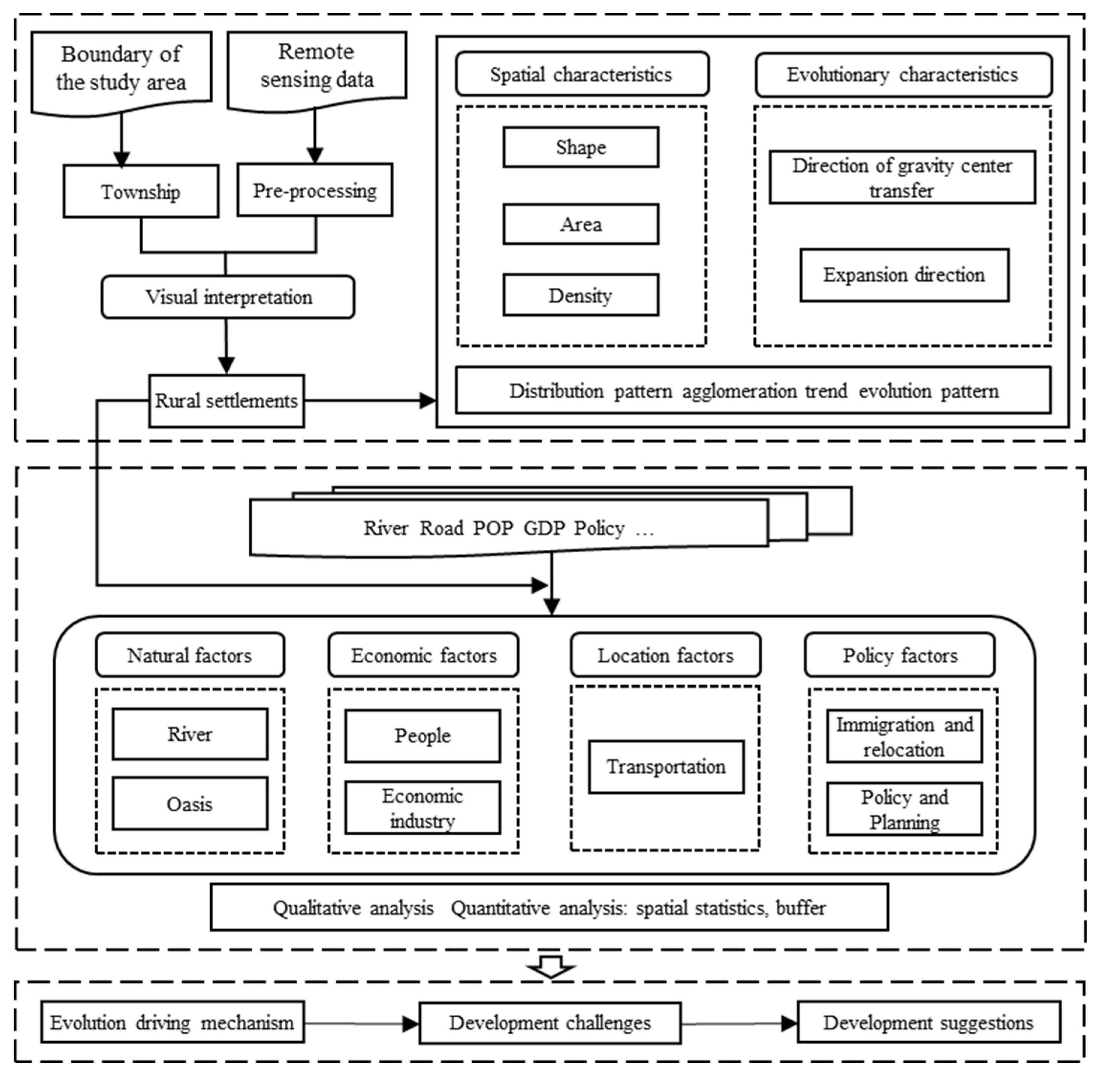
The research framework of this paper consists of two parts: rural settlements identification and its spatio-temporal pattern analysis based on remote sensing images, and analysis of influencing factors for rural settlements (Figure 2). Based on ArcGIS, spatial technologies were used to comprehensively analyze: (1) the evolutionary characteristics of rural settlements, (2) the gravity center of rural settlements, and (3) their relationship with the factors driving their evolution.

2.3.1 Extraction of rural settlements

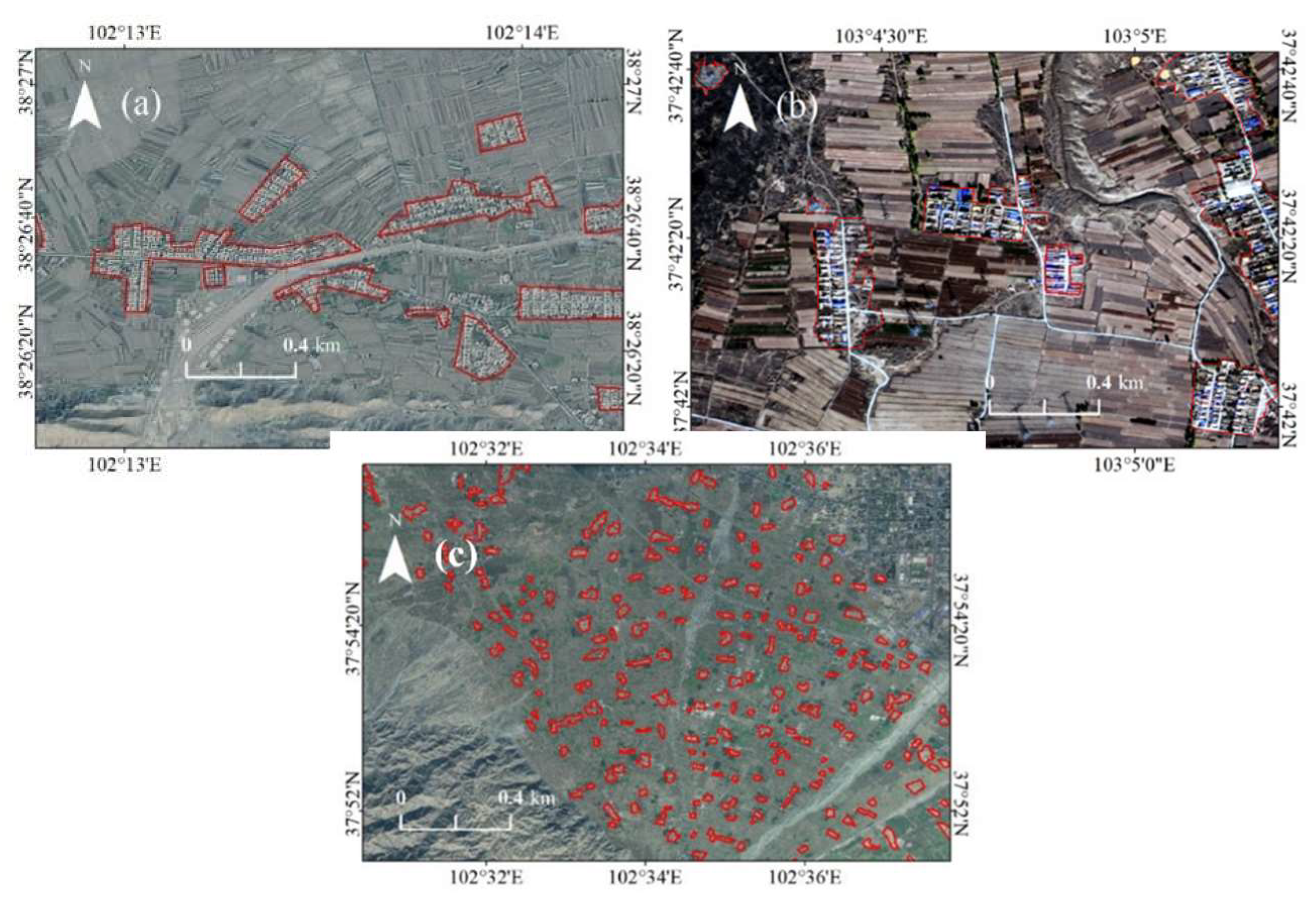
Using the visual interpretation method of remote sensing images, this paper processed the remote sensing images of the Shiyang River basin in 2000, 2011 and 2019: First, the images were imported into ArcGIS. Then, the residential patches were identified according to the location, shape, layout and other characteristics of the elements in each image. Create a new layer in the software, edit according to the contour of the settlements, and finally obtain maps of the residential patch for three years (Figure 3).

2.3.2 Change in rural settlement area and its annual change index

The area of land under rural settlement is the cornerstone of exploring how rural settlements have evolved. Its spatial changes can reflect the degree of rural settlement evolution over a period of time. Below, ∆RSA indicates the absolute change in the area of a give rural settlement patch within a certain period:
R S A = R S A n + i R S A i
To obtain the yearly trend in its variation, an annual change index of rural settlement area (RSAI) is introduced:
Preprints 76958 g014
where RSAI is the annual percentage change in the area of given rural settlement patch; in both equations above, RSAn+i and RSAi represent the rural settlement area in the year of n+i and i, respectively; and n is the time interval (in years).
The average nearest neighbor ratio (NNI) is obtained by comparing the observed values of the nearest neighbor distance with the expected values in a random mode [6, 40]:
N N I = d ( N N ) d ( r a n )
d ( N N ) = i n M i n ( d i j ) N
d r a n = 0.5 A n
Where, NNI is the average nearest neighbor ratio; d(NN) is the nearest neighbor distance; N is the number of samples; Dij is the distance from point i to j; Min(dij) is the distance from point i to the nearest neighbor point; d(ran) is the theoretical value of the average distance; A is the area of the research area; The nearest neighbor coefficient is used to determine the distribution pattern of rural settlement clusters, with NNI >1 indicating dispersed distribution and NNI<1 indicating aggregated distribution.

2.3.3 Rural settlement gravity center migration model

The regional gravity center model was used to explore the temporal migration of rural settlements on the landscape. Conceptually, it relies on principles of mechanics to express the regional center of gravity coordinates [41-42]:
X = i = 1 n ( C i X i ) i = 1 n C i
Y = i = 1 n ( C i Y i ) i = 1 n C i
where X and Y are longitude and latitude coordinates of the distribution centers of rural settlement patches, respectively; Ci is the area of the i-th rural settlement patch; n is the number of rural settlement patches; the Xi and Yi are longitude and latitude coordinates of the center of gravity of the i-th plate of rural convergence. The rural settlement center of gravity’s shift angle is as follows:
a i + 1 = arctan ( y i + 1 y i x i + 1 x i ) , x i + 1 x i π arctan ( y i + 1 y i x i + 1 x i ) , x i + 1 < x i
where ai+1 is the gravity shift angel of rural settlement; xi and yi are longitude and latitude of the rural settlement in the i-th year; while xi+1 and yi+1 respectively are the longitude and latitude of the rural settlement in the i+1-th year. Hence, the distance that the rural settlement center of gravity has moved can be calculated this way:
L i + 1 = ( x i + 1 x i ) 2 + ( y i + 1 y i ) 2

3. Results

3.1. The spatiotemporal distribution pattern of rural settlements

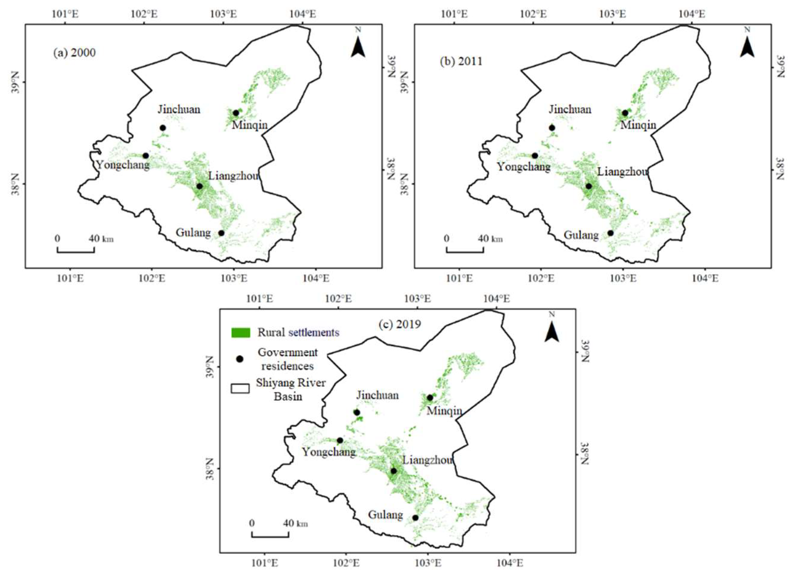
As shown in Figure 4, the rural settlements in the Shiyang River Basin are concentrated in the oasis areas. Mainly, they distributed in the Minqin Oasis, Liangzhou Oasis, Jinchuan Oasis, Yongchang Oasis, and the valleys of Gula County, showing a pattern of patchy and strip distribution. The rural settlements in the Minqin Oasis are distributed along both sides of the highway between the urban area and Xiqu Town, with two. While, the items in Liangzhou District are distributed in patches with a relatively high density. The number of rural settlements in Jinchuan District is relatively small, distributed in strip patterns along both sides of the river and the northern oasis. The rural settlements in the eastern part of Yongchang County are distributed in a fan-shaped pattern in the river impact zone, and the rural settlements in the valleys are distributed in strips along both sides of the river. The distribution density of rural settlements in Gula County is relatively small, with most of them located in mountainous and gully areas.
Figure 5 shows the spatial changes of rural settlements in the Shiyang River Basin from 2000 to 2019. In the period from 2000 to 2011, the disappearance of rural settlements decreased, while the number of newly added objects increased (Figure 5a). It can be inferred that rural settlements experienced an expansion trend during the period from 2000 to 2011. The main areas where rural settlements increased were Liangzhou District, Gula County, and Minqin County. The newly added rural settlements in Liangzhou District were mainly distributed in the northeastern part of Liangzhou, and the eastern oasis near the river. The same kind in Gula County were mainly distributed in the northern part. And, the newly established in Minqin County were mainly distributed in the southern oasis. After that, many old rural settlements disappeared, while other new rural settlements were added from 2011 to 2019. Rural settlements showed a coexistence pattern of disappearance and expansion, but the former outnumbered the latter. The lost rural settlements were mainly concentrated in the southern part of Gula County and the northeastern part of Minqin County. The greatly increased were mainly clustered in Liangzhou District and Minqin County (Figure 5b). The disappearance in the northern oasis of Minqin County, and rural settlements in valleys and gully areas in Gula County, as well as was relatively obvious.

3.2. Area evolution characteristics of rural settlements

The paper is based on spatial data of rural settlements in the Shiyang River Basin from 2000 to 2019, and calculates the area and annual growth rate of rural settlements in different regions as shown in Table 1.
Regionally, there are significant differences in the expansion area of rural settlements in the Shiyang River Basin from 2000 to 2019. The largest and smallest areas are Minqin County and Jinchuan District, with expansion areas of 1.01 km2 and 0.07 km2, respectively. In terms of different time periods, most counties had higher annual growth rates for rural settlements from 2011 to 2019 than from 2000 to 2011. After 2011, except for the slowdown in the expansion rate and reduction in expansion area of rural settlements in Minqin County, the expansion speed of rural settlements in other regions increased significantly, and the expansion area increased year by year.

3.3. Density evolution characteristics of rural settlements

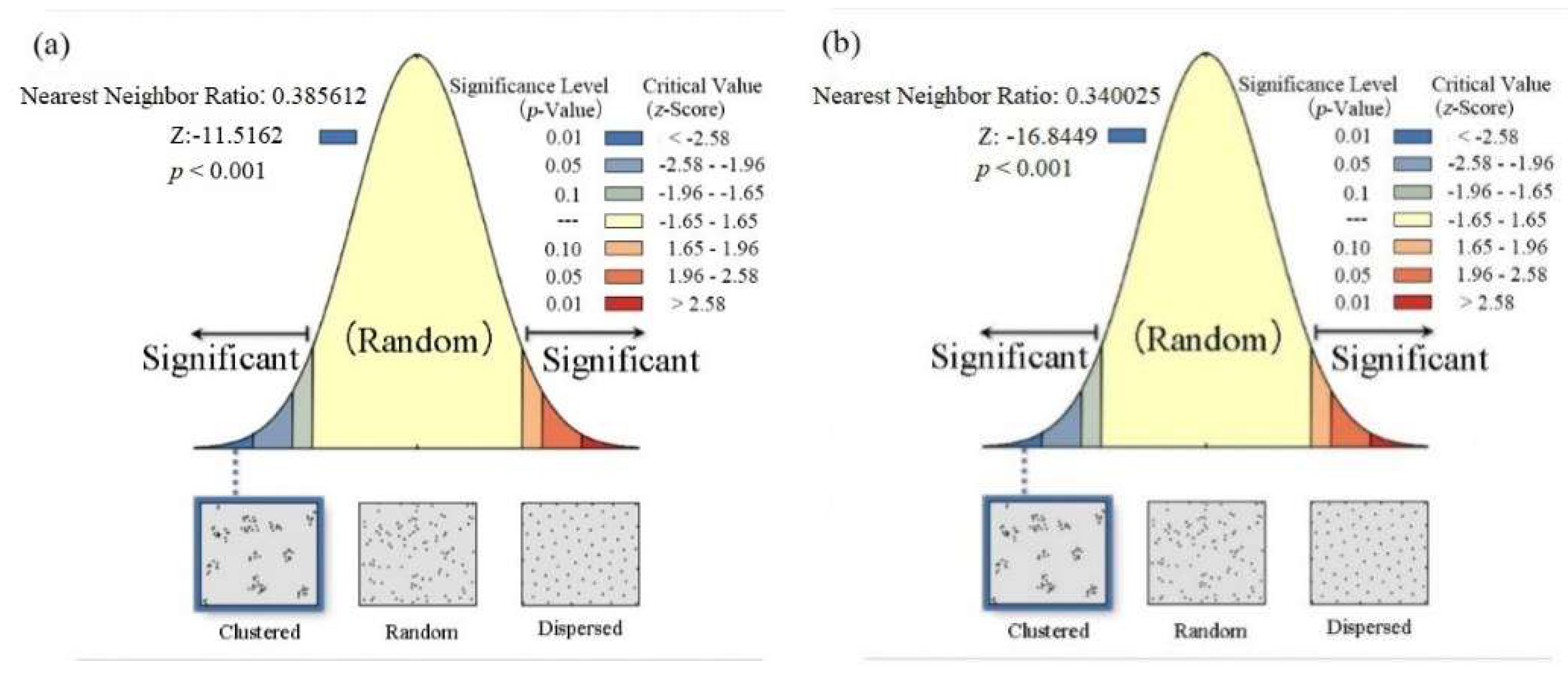
The purpose of the section is to explore the distribution pattern of rural settlements in the Shiyang River Basin. The nearest neighbor ratios are calculated to observe the clustering pattern of newly added rural settlements in the Shiyang River Basin in two periods (Figure 6). The results show that the average nearest neighbor ratios of newly added rural settlements in the basin in the two periods of 2000-2011 and 2011-2019 are 0.39 and 0.34, respectively. The fact that the ratios are all less than 1 indicating that the newly added rural settlements are clustered. The z-values are -11.52 and -16.84, respectively, and both passed the 99% significance test. The overall distribution of rural settlements tended to be clustered and the scale tended to be regular from 2000 to 2019. However, in the early stage, the expansion was relatively obvious. Until 2019, the density and scale of rural settlements in the Shiyang River Basin were still relatively small.

3.4. Evolution characteristics of rural settlements’ gravity center

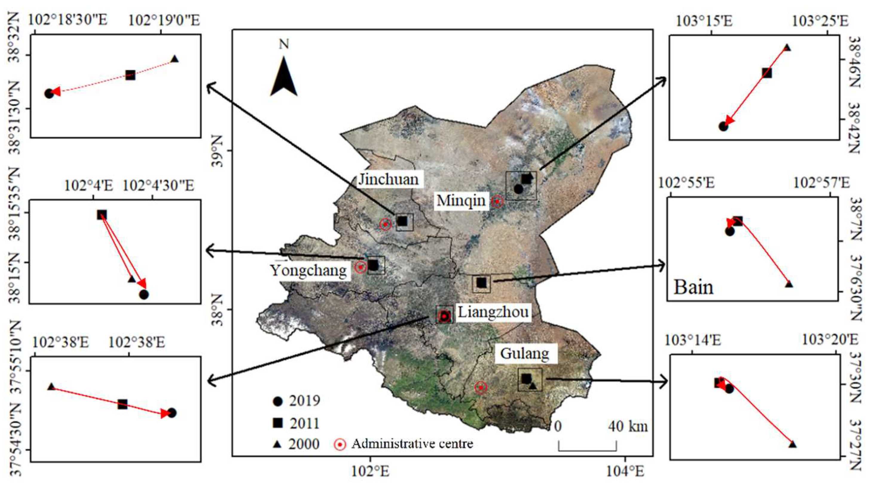
The changes in the gravity center of the rural settlements in the study area depend on the calculation of the gravity center coordinates (Figure 7). Over the past 20 years, the rural settlements in the basin have shown a contraction trend. The gravity centers of counties in the northern basin have migrated southwest. Overall, there is a clear trend of westward migration of rural settlements. In the period of 2000 to 2011, the gravity center coordinates migrated overall to the northwest. And, the gravity center coordinates shifted overall to the west from 2011 to 2019. Minqin County had the largest change in gravity center with 12775.13 meters (Table 2&Table 3). During the period of 2011-2019, the distance was more than twice that of the previous period. Followed by Gula County, the migration changes mainly occurred from 2000 to 2011 with 5744.88 meters. Yongchang County had the smallest change in gravity center migration, with 252.69 meters. Liangzhou District and Jinchuan District were relatively stable during the two time periods.

3.5. Factors influencing the evolution of spatial pattern of rural settlements

3.5.1. Natural factors

The constraint of natural environmental factors in the western regions of China is particularly prominent, while striving for high-quality development. Therefore, it is particularly meaningful to facilitate rural revitalization by conducting an in-depth analysis of the impact of natural factors on the distribution, and exploring the layout and evolution trends of rural settlements.
(1) Distance between rural settlements and rivers
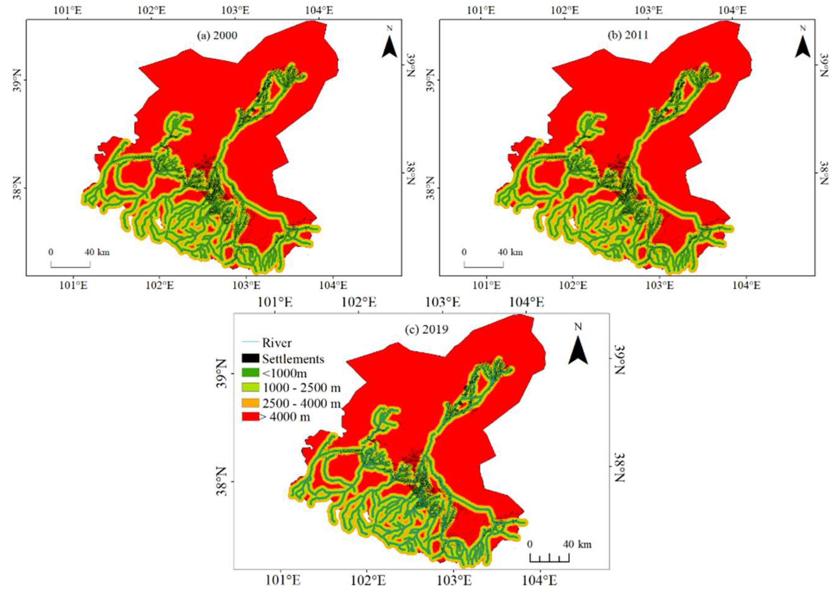
Water source is not only a basic condition for villagers' life, but also a necessary condition for agricultural development. Therefore, the rural settlement built near water sources will effectively improve residents' production and living efficiency. Specifically, the source of water is a pivotal consideration, it being the most vital resource for production and living in arid regions. By overlaying the layer of river distance with the layer of rural settlements, it can be analyzed that rivers are distributed in all towns and villages in the Shiyang River Basin, with the most distributed in Liangzhou District. The distance from each rural settlement to the nearest river was categorized into one of four levels: < 1000 m, 1000–2500 m, 2500–4000 m, or > 4000 m. As seen in Figure 8, rural settlements in the Shiyang River Basin are mainly distributed in the proximity of rivers. The rural settlements located more than 4,000 meters away from rivers are mainly distributed in the valley areas of Gula County and the northwest part of Liangzhou District. The number of rural settlements within 1 km from a river in 2000, 2011, and 2019 respectively accounted for 38.88%, 40.23%, and 39.83% of the totals in those years. By contrast, the number of rural settlements situated more than 4 km from a river in 2000, 2011, and 2019 accounted for much lower proportions (respectively, 7.32%, 7.54%, and 8.59%) of the same totals (Table 4). There is a clear inverse relationship between the distance of the region from the river and the number of rural settlements. From 2000 to 2019, the number of rural settlements in all regions has increased, but within a distance of <1000m from rivers, objects has increased significantly.
(2) Relationship between rural settlements and the oasis margin
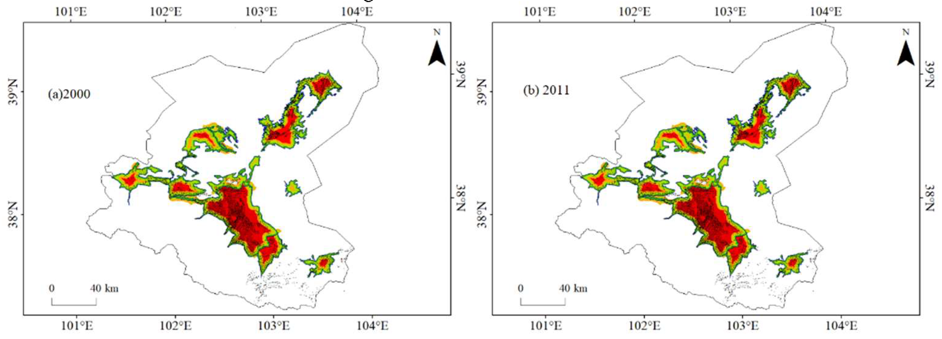
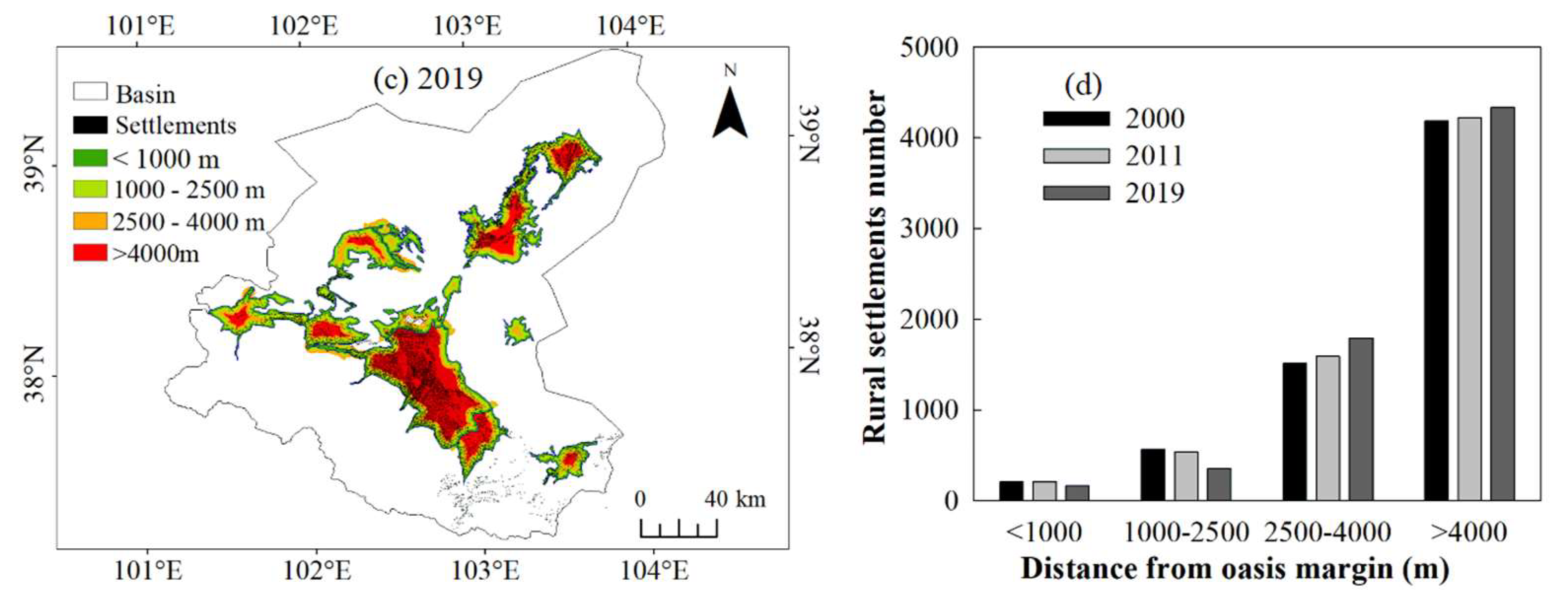
An oasis is a valuable natural habitat and resource in arid regions, where the development of cities and rural settlements is closely related to the evolution of oases. We investigated the relationship in location between rural settlements and oases in 2000, 2011, and 2019. In the Shiyang River Basin, except for its southeastern part, most of its rural settlements were distributed within 4 km of an oasis, albeit being mainly concentrated in zones farther from margins of oases (Figure 9). The rural settlements in the research area are greatly limited by the conditions of the oasis, and their trend towards the central area of the oasis is significant.

3.5.2. Socio-economic factors

Socio-economic conditions represent the potential for production and life. Among them, a large population enhances the vitality of the region, and well-connected roads convenient for production and life. The development of a strong economy and high-quality rural living standards is conducive to the agglomeration of rural population and industrial development.
(1) Relationship of rural settlements with population
Human beings are one of the most basic components of the social system. As the guidance for corresponding layout planning and construction, rural development and construction are all human needs are all complied. Therefore, changes in the population have a great impact on rural construction. This paper statistically analyzes the changes in rural population size from 2000 to 2019 in each county and region within the basin. From 2000 to 2019, the urbanization rate of the Shiyang River Basin increased from 21.94% to 48.86%. It is surveyed that the registered population in rural areas was 1.6864 million, while the rural resident population was 1.1676 million in 2019. Urbanization promotes the unprecedented expansion of urban population size and spatial scale, and industrial structure optimization drives labor flow and higher education popularization pulls population flow, which has an important impact on rural settlements. Affected by urbanization, the overall trend of changes in villagers' groups shows an increasing trend.
(2) Relationship of rural settlements with economic industry
The economic industry is the basic driving force of urban development as well as the main pillar of rural development. Generally, changes in the industrial structure of the economy will lead to corresponding alteration in the land functions that serves as the main carrier of economic construction. Subsequently, the spatial pattern of rural construction is updated by the new land use situation. Therefore, he spatial-temporal evolution of rural settlements is inseparable from regional economies. The economic development and urbanization process of the Shiyang River Basin in the three periods are shown in Table 3. From 2000 to 2019, the total economic output of the Shiyang River Basin increased nearly eightfold (Table 5), and the level of social and economic development gradually improved. As can be seen from the changes in the economic industrial structure over the years, the proportion of the primary industry has always been the lowest, while there have been changes in the structure between the secondary and tertiary industries. The economic industrial structure of the basin underwent adjustments in the second period, and the tertiary industry began to serve as the economic backbone. The development of the overall economic structure of the basin is bound to affect the adjustment of the rural economic structure. Currently, the three types of land use in rural areas of the basin mainly include: modern agricultural industry parks, new industrial parks, energy industry bases, equipment manufacturing parks, etc. The three types of land use mainly include residential quarters, tourist resorts, etc. Especially with the development of tourism in Zhangye City and Wuwei City, tourist facilities and entertainment venues in rural areas have increased explosively.

3.5.3. Locational factor

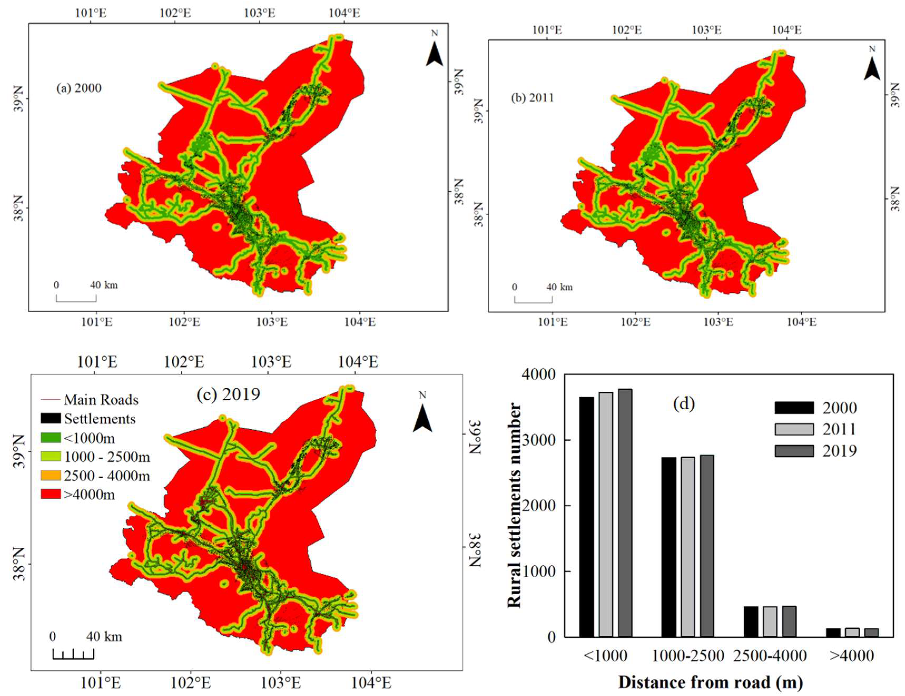
Transportation is a special advantage given by geographical factors to human activity areas. The transportation location reflects a geographical economic phenomenon. Traffic roads are an important factor affecting the distribution of rural settlements, because the former facilitate the latter’s expansion and linkages (trade and human migration), whose construction often tracks natural landforms. Based on their distance from the nearest main road—national, provincial, and rural roads—four classes were grouped rural settlements: those < 1000 m, 1000–2500 m, 2500–4000 m and > 4000 m from a road. As Figure 10a shows, in 2019, the rural settlements were mainly distributed within 4 km of a main traffic road; however, from 2000 to 2019, it is evident that the number of rural settlements decreased with increasing distance from roads. The number of rural settlements is inversely proportional to the distance from the main road. Among them, the area within 1000m from the main road has the densest rural settlements, accounting for 52.3%, 52.7% and 52.8% in the three periods, respectively. Exploring for the details with time scale, the number of rural settlements within 1000m of the main road has been increasing, while the rest of the area has shown a decreasing trend.

4. Discussion

4.1. Development model of rural settlements in the Shiyang River Basin

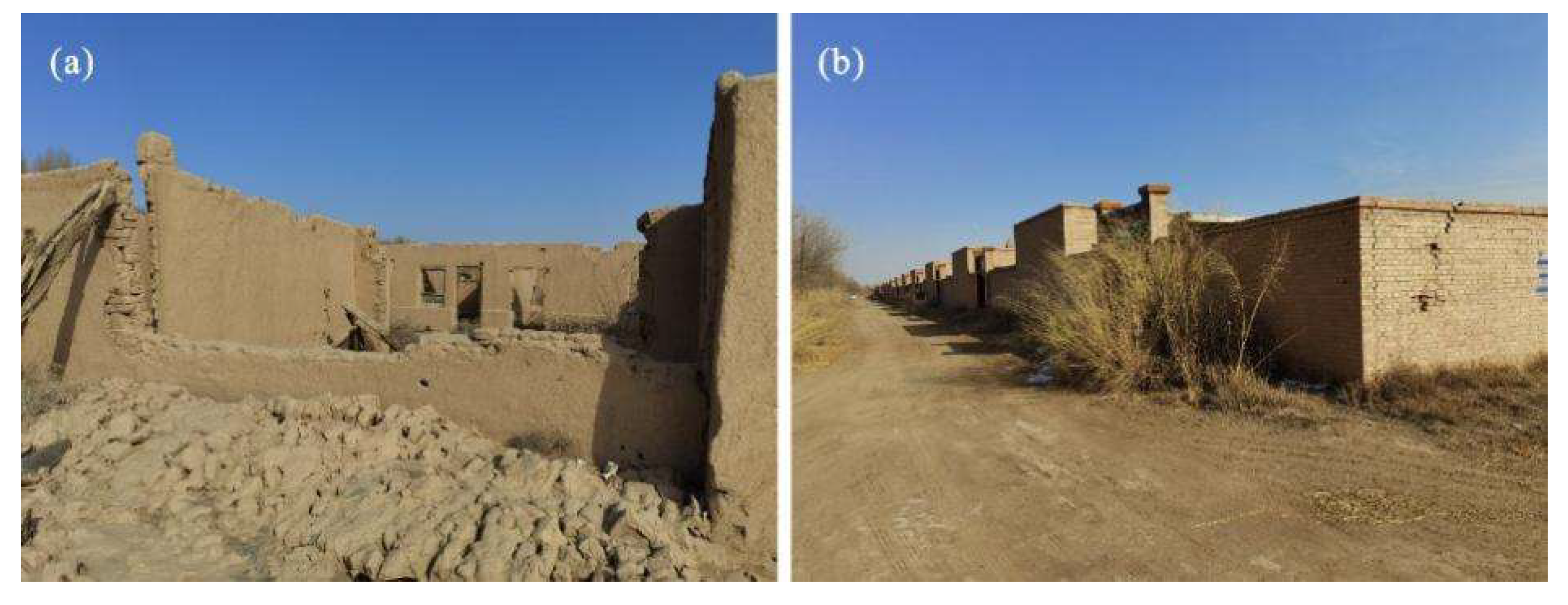
From 2000 to 2019, the spatial distribution pattern of rural settlements in the Shiyang River basin showed that some new settlements accompanied by others disappeared. From 2000 to 2011, the number of rural settlements has increased significantly in the Shiyang River Basin. However, between 2011 and 2019, although many new rural settlements appeared more established ones disappeared. We also investigated the changed coverage of rural settlement areas in the Shiyang River Basin, which our results show increased overall from 2000 to 2019. This increase can be explained by more rural settlements established from 2000 to 2011. From 2011 to 2019, with relatively fewer newer rural settlements, the land area occupied per rural settlement unit rose, indicating that the scale of individual rural settlements is increasing. Figure 11 clearly shows that the new rural settlements are indeed larger than the older ones. These findings suggest the development mode of rural settlements in Shiyang River basin has undergone significant changes in just a 20-year period, shifting from being greater in number during 2000–2011 to greater in size in 2011–2019.
The spatial pattern changes of rural settlements obtained in the previous section can be used as the basis for identifying the development patterns of settlements. Through literature review [43-44], there are three main evolutionary patterns of rural settlement size in the spatial distribution of the Shiyang River Basin, namely, shrinkage mode, diffusion mode, and conversion mode. The shrinkage mode refers to the transformation of rural settlements into urban or other types of land. This phenomenon mainly occurs in the outskirts or surrounding towns of government jurisdiction. For example, from 2007 to 2010, Huaer village in Xindun town of Zhangye city was transformed into an urban area after being requisitioned by government agencies as the city continued to expand. In particular, with the rapid development of urbanization, rural settlements near towns with larger urban scales and better economic conditions began to transform into urban land. The diffusion mode refers to the expansion of rural settlements outward from their original locations. For example, from 2012 to 2017, Dongwan Village near Ningyuanbao town followed the approach of "reclaiming land from the mudflat, demolishing the olds and building the news," and built thousands of high-standard farmhouses on large areas of barren beach, bringing the settlement closer to the city. In addition, the government have implemente immigration policy such as the "Dingxi and Hexi" immigration policy, the "Ecological immigration and poverty alleviation development in Huanghuatan", promoted the expansion of rural settlements with introduction of external populations. The conversion mode is to change the structure and morphology of settlements through renovation and reconstruction. After the transformation of the idle village in Xiejiawan Village, Wujiang Town, Ganzhou District, the village style has been maintained with a shared farm. The development of tourist check-in tourism industry is in full swing. The increasing efforts in the construction of new rural areas have improved the appearance of villages, and some dilapidated and scattered settlements has been converted from construction land to farmland.
The changes in the industrial structure of rural areas had break the original layout of rural settlements, which are mainly residence. The pattern and functions of rural settlements will be adjusted depend on industrial development, leading to changes in their individual sizes, numbers, densities, and economic incomes. The aggregation of changes in individual will cause changes in the overall spatial pattern of rural settlements.

4.2. Main driving factors of rural settlement dynamics in an arid region

Topographic is one of the main factors in the selection of sites for rural settlements. Generally, settlements tend to be located in areas with relatively flat terrain and facing towards the sun for production and living construction. However, the Shiyang River Basin belongs to arid climate conditions, and the human activity concentrated areas are mainly located at the river outlets. Through the analysis of the DEM within the study area, it is found that the terrain in the area where the rural settlements are located does not have significant undulations and changes. The main changes are in the Qilian Mountains with a few settlements, and they rely on the piedmont fans of the mountains for development. Therefore, factors such as topography, slope, and aspect do not have a significant impact on the development and changes of the settlements. The Minqin Basin is located in a low-lying hilly area in the plains. It is deeply sandwiched between two famous deserts (Tengger Desert and the Badain Jaran Desert), to limit the expansion of rural settlements. As a result, the loss of rural settlements in fragile ecological environments at the oasis and desert interface not only reduces the development and utilization of water resources, but also poses new challenges for regional ecological environment protection and desertification control.
The paper found that the spatial distribution of rural settlements is closely related to the location of rivers, roads, and oases, as well as population changes. In semi-arid regions, as the most important natural resources, rivers playing an indispensable role in production and life. Most rural settlements are located near rivers. The cultivated land in the Shiyang River Basin is mainly irrigated land, located close to rivers for irrigation purposes. Correspondingly, the settlements are located around cultivated land or embedded within it, with water supplied through irrigation canals along the way. Especially, the scale increased even more after 2010. It is related to the continuous development of desert areas and resettlement of ecological migrants in recent years. For instance, Nanhuxi town in Minqin County, Huanghuatan town and Zhitancun town in Gula County, and Minghua town in Sunan County.
Roads are the result of human activities on the basis of landforms. With the construction of cement roads in various towns, villages are now connected more closely to the outside. Accordingly, rural residents prefer to locations near conveniently accessible roads and beautiful environments. In addition, rural settlements have a lower dependence on high-level roads such as high-speed rail. For example, Huanghuatan town and Haizitan town in Gula County continue to develop uninhabited areas for construction of settlements. In the Hexi Corridor, roads are closely related to river valleys and river terraces, which were formed by the action of rivers. Typically, roads are built on river valleys or river terraces. Therefore, the distribution of roads is determined by the location of rivers.
In a developing environment, rural areas generally show a population outflow. During the second period of research, with the acceleration of urbanization, the number of agricultural populations began to decrease, and phenomena such as deserted settlements at the edges of oases and in high-altitude areas emerged. The reason is that rural residents gradually migrate to cities or seek employment elsewhere, but the original settlements or abandoned the olds have not been phased out in a timely manner for optimal allocation. So as to a phenomenon of "hollowing out" within rural settlements. During the first period, with the implementation of policies such as agricultural industrialization and the waiver of agricultural taxes, the number of people engaged in agricultural production increased, and the prices of economic crops rose. The improvement of economic efficiency has stimulated an increase in the scale of agricultural land use and consumption levels, which is conducive to the expansion of rural settlements.
Besides, policies are the leading factor that directly affects changes in rural settlements. By checking government gazettes in the region, it was found that Shiyang River Basin has caused some expansion of rural settlements due to urban-rural integration, while at the same time, due to policies such as relocation, some rural settlements have disappeared [45].
(1) Poverty alleviation and immigration
In 1982, China proposed the prototype of poverty alleviation and migration, to construct resettlement bases for migrant. The plan prompted more rural population to migrate, thus promoting the abandonment and expansion of rural settlements. In 2016, it was the start for the national promotion of poverty alleviation relocation project. The National Development and Reform Commission issued the "13th Five-Year Plan for Poverty Alleviation Relocation", emphasizing the importance and urgency of poverty alleviation relocation. The state regards relocation as a major policy, measure and Megaproject during the 2016-2020, and will fully promote it. In 2007, the "Shiyang River Basin Key Governance Plan" proposed ecological migration as an important measure to solve the deterioration of the ecological environment. The policy of ecological migration, including resettlement outside the county, resettlement within the county, and self-employment resettlement, greatly increased the enthusiasm of villagers to build new houses, and caused significant changes in rural settlements. Before 2010, 10,500 people in the northern part of Minqin Lake area with poor natural environment and no guarantee of production and living were resettled through ecological migration. From 2011 to 2019, 13,500 people in the Qilianshan Mountain Water Source Forest Reserve were resettled through resettlement. Since 2011, the resettled residents in settlements were continuously relocating to the eastern desert area of Liangzhou District and Huanghuatan Township of Gula County. From 2011-2020, the poverty alleviation relocation in Zhangye City involved Linze, Gaotai, Shandan, and Minle counties, which implementing housing construction, supporting infrastructure construction, public service facility construction, land consolidation and ecological restoration. In particular, modern agricultural industry parks were built relying on the national rural industrial integration development demonstration park, had promote the employment of resettled residents, social governance, and subsequent industrial development, and effectively change the spatial and temporal pattern of rural settlements in the basin.
(2) Integration of urban and rural development
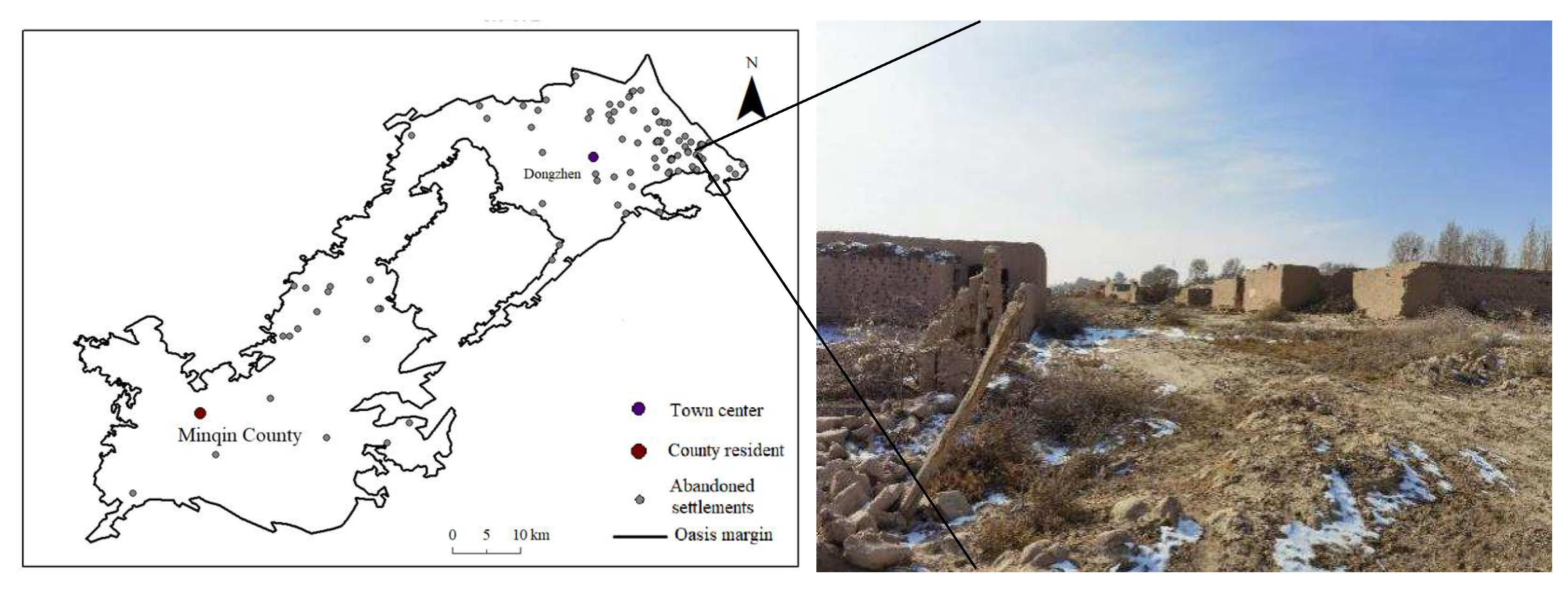
Integration of urban and rural development, a new type of urban-rural relationship, was put forward. The essence is the development of urban and rural elements flow, with urban guiding the rural development. Since the 21st century, the organic combination of improving rural human settlements and developing rural tourism, leisure agriculture, characteristic industries, etc. has continuously promoted the construction of urban and rural integration demonstration areas, accelerated environmental remediation and the circulation of production factors among counties, and achieved mutual promotion between the integration of rural industries and the improvement of human settlements. Among them, Wuwei City proposed and implemented the strategy of urban-rural integration development in 2010, implemented new rural construction and built 51 resettlement new rural sites such as Huanghuatan Ganen new village and Yangguang new village in Gula County. The urbanization pilot was carried out in Huangyang Town of Liangzhou District and Huangyangchuan Town of Gula County, initially building a distinctive urbanization demonstration zone, which greatly changed the infrastructure and village appearance of rural areas. The construction of Jinse Road expanded the construction space of new rural communities, and 73 new rural community communities were built along the road, involving 7659 households. Driven by government policies, rural settlements continuously evolved with disappearing and coexisting (as shown in Figure 12).
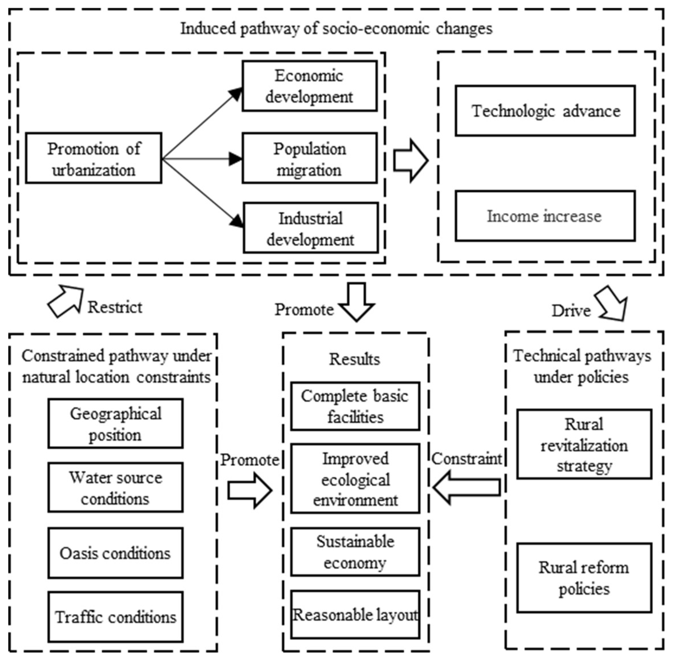
In summary, the time and space evolution of rural settlements is influenced by a variety of factors. Under the constrained pathway under natural location constraints, the climate and natural conditions are relatively high in the distribution of the rural settlement area. The problems of poor survival environment, underlying resource conditions, directly hinder the development of countryside settlement, resulting in abandoned settlements. Under the induced pathway of socio-economic changes, rural industrialization, urbanization, population growth and improved production technology promote the improvement of the regional economic level, new construction and reconstruction work promotes the expansion and evolution of rural settlements. Under the technical pathways under policies, preferential policies promote population and capital flows, promote rural development, curb rural settlement emptying and waste of land resources, lay an important foundation for further sustainable development of countryside settlement.
The three paths interfere and constrain each other to jointly promote the development of rural settlements in the basin (Figure 13). The ultimate goal is to make a reasonable layout of the countryside, improve the infrastructure system, and improve the rural ecological environment and sustainable development of the rural economy.

4.3. Optimization of spatial layout

Obviously, the most important natural factor affecting the spatial distribution of rural settlements in the Shiyang River basin is water resources. Nevertheless, the impact of policies on the spatial distribution of rural settlements cannot be overlooked, especially in 2011-2019.Based on the requirements of "Guiding the development of rural classification", "Classification and orderly promotion of village planning and management" in the "Zhangye City's General Land Space Plan (2021-2035)" and "Agglomeration improvement, suburban integration, characteristic protection, and relocation". In combination with the distribution of water resources in the basin, the type of optimization of rural settlements spatial layout in the basin is divided into 4 categories: urbanization classes, development classes, control classes, and migration classes.
(1) Urbanization classes. In order to coordinate the process of regional urban and rural integration and improve the urbanization rate, the country's "new rural construction" and "new urbanization" strategic measures have accelerated the pace of rural urbanization. So, some rural settlements are confronted with a new merger and restructuring. In the case of the Shiyang River Basin, it is possible to incorporate the economic and industrial development of the existing urban planning, the density of the population, the rural settlements closer to the main urban area as the reserve zone for future urban development, into the urban system. (2) Development classes. With the city center outward, resources are rich, ecological resilience is high, and areas closer to the water source are settlements. In the future, the part of the rural settlements will be used as an outflow zone for urban economic development, and will bear the outflow benefits of the economic development of the city, and can be used to undertake the development of industrial industries that are not suitable for urban development, as well as the area for settlement and migration of the fusion of rural settlements. (3) Control classes. As a buffer for rural development and ecological coordination, this part of the future rural resident point should be carefully developed, retaining its size and controlling the boundaries of village development. (4) Migration classes. Projects located in Qlian Mountain National Park, as well as ecologically sensitive and highly sensitive areas, continue to develop and cause immeasurable losses to the ecological environment. Furthermore, future development will occupy areas of basic agricultural land and should be closely integrated into areas with high habitability.

4.4. Limitation and prospects

The findings can provide a certain reference for the future development of rural residential areas in dry inland river basins. Certainly, this study could do a better job for further improvement and expansion. The data used in this paper varies from years, and the image recognition results of different resolutions inevitably produce some spatial deviation. These deviations could lead to minor changes in rural settlements on the edge of the pixel. In addition, only a handful of representative natural and social factors have been selected, with a certain degree of subjectivity. It is lack of the effects of natural disasters, especially the Shiyang River Basin, one of China's largest sandstorm sources. And, there is a lack of in-depth excavation and quantitative analysis of the driving mechanisms, caused by unobtainable detailed data. In the future, we should improve the fine-tuning and dynamics of the indicators, build an evaluation system, and ensure the scientific, rational and operational feasibility of optimizing the layout of rural settlements.

5. Conclusions

The Shiyang River basin is a typical continental river basin in the arid area. In this study, the spatial distribution and driving mechanisms of rural settlements in the basin were examined. Then, the evolution law of rural settlements in arid inland river basins were explored and revealed from the perspectives of natural geography, socio-economy, location conditions, and policies, has important practical value for guiding the rural revitalization of special inland river basins. The main conclusions are as follows.
(1) From 2000 to 2019, the scale of rural residential areas in the Shiyang River basin showed an expansion trend, and the spatial distribution pattern was coexistence of new settlement and disappearance. The evolution process in spatial distribution mainly includes the shrinkage mode, diffusion mode, and conversion mode. Urbanization is driving the transformation of rural settlements. Economic growth promotes the improvement of people's living standards and their pursuit of a high quality of life. These changes in turn affect industries, agriculture, and commerce, promoting the evolution of urban-rural structures.
(2) Over the past 20 years, rural settlements in the basin have shown a trend of agglomeration and migration to the southwest. The concentration of rural settlement in the Shiyang River Basin is distributed across the oasis area in a pattern of fragmented and band-shaped distribution. Their spatial distribution varies greatly, showing a trend of being sparse in the northeast and dense in the southeast. Among them, from 2011 to 2019, the growth rate of rural settlements near Minqin slowed down rapidly whereas those near Liangzhou and Jinchang expanded significantly.
(3) The distribution of rural settlements is characterized by being close to water and roads, and is greatly influenced by urban-rural integration and ecological migration. At the same time, the scope of human production and living activities near roads and rivers is significantly increasing. As a result, there are many villages in cities and abandoned settlements. It is necessary to optimize the spatial layout of settlements in combination with local planning needs in the basin. A more comprehensive quantitative evaluation system can ensure that optimizing the layout of rural settlements is scientifically, reasonably, and operationally feasible. This is needed to improve the relationship between people and land, to enhance the utilization rate of resources, and to promote long-term ecological security and regional sustainable development.

Funding

This work was supported by the National Natural Science Foundation of China (grant no. 42261031) and the Natural Science Foundation of Gansu Province (grant no. 22JR5RA547).

Acknowledgments

We thank Dr. Julian Norghauer for critical discussions, constructive suggestions and English improvement.

References

  1. Doyle C J, Morag M, Kairsty T. 2000. Effectiveness of farm policies on social and economic development in rural areas. European Review of Agricultural Economics, (3-4): 530-546.
  2. Li G Y, Jiang C H, Du J, et al. 2020a. Spatial differentiation characteristics of internal ecological land structure in rural settlements and its response to natural and socio-economic conditions in the central plains, China. The Science of the Total Environment, 709: 13593.
  3. Zhou Y, J. 2018. Measures and policy suggestions for improving rural settlements in Guangdong[J]. Journal of Landscape Research, 10(3): 43-49.
  4. Dong G L, Zhang W X, Xu X L, et al. 2021. Multi-Dimensional Feature Recognition and Policy Implications of Rural Human–Land Relationships in China. Land, 10(10): 1086.
  5. Oostrum M, V. 2021. Access, density and mix of informal settlement: comparing urban villages in China and India. Cities, 117: 103334.
  6. Sun D L, Hong B T, et al. 2022. Spatiotemporal evolution and driving factors of the rural settlements in the mountain-plain transitional zone. International Journal of Agricultural and Biological Engineering, 15(2): 149-155.
  7. Dasgupta, S. 1983. Analysis of the processes of evolution of rural settlements in the moribund Ganges delta 1921 to 71. Calcutta: University of Calcutta.
  8. Sevenant M, Antropl M. 2007. Settlement modes, land use and versatility in rural landscapes: Two case studies in Greece. Landscape and Urban Planning, 80(4): 362-374.
  9. Long H L, Liu Y S, Wu X Q, et al. 2009. Spatio-temporal dynamic patterns of farmland and rural settlements in Su–Xi–Chang region: Implications for building a new countryside in coastal China. Land Use Policy, 26(2): 322-333.
  10. Dahms F, A. 2010. The evolving spatial organization of small settlements in the countryside–an Ontario example. Tijdschrift Voor Economische En Sociale Geografie, 71(5): 295-306.
  11. Shinde N N, Gajhans D S. 2015. Distribution pattern of rural settlement of Jalgoan district. Indian Streams Research Journal, 4(12): 1-4.
  12. Zhou J, Hou Q. 2021. Resilience assessment and planning of suburban rural settlements based on complex network. Sustainable Production and Consumption, 28: 1645-1662.
  13. Tian G, Qiao Z, Zhang Y. 2012. The investigation of relationship between rural settlement density, size, spatial distribution and its geophysical parameters of China using Landsat TM images. Ecological Modelling, 231: 25-36.
  14. Conrad C, Rudloff M, Abdullaev I, et al. 2015. Measuring rural settlement expansion in Uzbekistan using remote sensing to support spatial planning. Applied Geography. 62(7): 29–43.
  15. Xing H, T. 2021. The spatial pattern planning method of rural landscape based on remote sensing technology. International Journal of Environmental Technology and Management, 24: 93-106.
  16. Asimakopoulos A, Mogios E, Xenikos D G. 2016. Geographic location, network patterns and population distribution of rural settlements in Greece. International Journal of Modern Physics B, 30(15): 1541009.
  17. Montis A D, Caschili S, Mulas M, et al. 2016. Fichera urban-rural ecological networks for landscape planning. Land Use policy, 50: 312-327.
  18. Sun P L, Xu Y Q, Liu Q G, et al. 2017. Spatiotemporal evolution and driving forces of changes in rural settlements in the poverty belt around Beijing and Tianjin: a case study of Zhangjiakou city, Hebei Province. Journal of Mountain Science, 14(5): 980-997.
  19. Huo X L, Xu X W, Tang Y, et al. 2021. An analysis of the spatial evolution and influencing factors of rural settlements along the Shandong section of the Grand Canal of China. River Research and Applications, 9: 3874.
  20. Tian Y S, Kong X S, Liu Y L. Combining weighted daily life circles and land suitability for rural settlement reconstruction. Habitat International, 2018, 76: 1-9.
  21. Li J T, Gong Y L. 2022. Spatial location differentiation and development decision optimization of characteristic villages and towns in China. Geography and Sustainability, 3(1): 21-31.
  22. Ma W Q, Jiang G H, Wang D Q, et al. 2018. Rural settlements transition (RST) in a suburban area of metropolis: Internal structure perspectives. Science of the Total Environment, 615: 672-680.
  23. Zhao Z J, Fan B L, Zhou Q B, et al. 2022. Simulating the coupling of rural settlement expansion and population growth in Deqing, Zhejiang Province, based on MCCA modeling. Land, 11(11): 1975.
  24. Roy S S, Jana N C. 2015. Impact of geomorphic attributes on rural settlement distribution: A case study of Baghmundi Block in Purulia District, West Bengal. International Journal of Innovative Research and Development, 4(8): 121-132.
  25. Dong X M, Xu S N. 2020. Spatial evolution characteristics of urban and rural settlements in Inner Mongolia. Arabian Journal of Geosciences, 13: 1214.
  26. Bański J, Wesołowska M. 2010. Transformations in housing construction in rural areas of Poland’s Lublin region influence on the spatial settlement structure and landscape aesthetics. Landscape and Urban Planning. 94(2): 116–126.
  27. Dong W, Yang Y, Zhou Y. 2011. Land use changes and evaluation of land use efficiency in an arid oasis city, A case of Urumuqi, China. Arid Land Geography. 34 (4): 679–686.
  28. Du Q, Xu H, Zhao X, et al. 2014. Changing characteristics of land use/cover and landscape pattern from 1990 to 2010 in the Kaxgar River basin, Xinjiang. Journal of Glaciology and Geocryology, 36 (6): 1548–1555.
  29. Chen P, Wang S, Liu Y X, et al. 2022. Spatio-temporal patterns of oasis dynamics in China's drylands between 1987 and 2017. Environmental Research Letters, 17(6): 064044.
  30. Yi F, Yang Q K, Wang Z J, et al. 2023. Changes in land use and ecosystem service values of Dunhuang Oasis from 1990 to 2030. Remote Sensing, 2023, 15(3), 564.
  31. Fang C L, Cui X G, Li G D.; et al. 2019. Modeling regional sustainable development scenarios using the urbanization and eco-environment coupler: Case study of Beijing-Tianjin-Hebei urban agglomeration, China. Science of the Total Environment, 689: 820–831.
  32. Heng J, Wang H, Fan Y, et al. 2021. Simulation and optimization of urban–Rural settlement development from the perspective of production–life–ecology space: A case study for Aksu City. Sustainability, 13(13): 7452.
  33. Liu S C, Ma L B, Yao Y, et al. 2022. Man-land relationship based on the spatial coupling of population and residential land-A case study of Yuzhong County in Longzhong Loess Hilly Region, China. Land Use Policy, 116: 106059.
  34. Shang H, Fan J, Fan B, et al. 2022. Economic Effects of Ecological Compensation Policy in Shiyang River Basin: Empirical Research Based on DID and RDD Models. Sustainability, 14: 2999.
  35. Li K, Chen R, Liu G. 2021. Cryosphere water resources simulation and service function evaluation in the Shiyang River Basin of Northwest China. Water, 13(2): 114.
  36. Li C H, Wang Y T, Wu X D, et al. 2020b. Reducing human activity promotes environmental restoration in arid and semi-arid regions: A case study in Northwest China. Science of The Total Environment, 2021, 768: 144525.
  37. Xu Y, Pu L J, Zhang L F. 2014. Spatial pattern and the process of settlement expansion in Jiangsu Province from 1980 to 2010, Eastern China. Sustainability, 6(11): 8180–8194.
  38. Shi M J, Xie Y W, Cao Q, et al. 2016. Spatiotemporal changes in rural settlement land and rural population in the middle basin of the Heihe River, China. Sustainability, 8(7): 614.
  39. Shan Z Y, Feng C C. 2018. The redundancy of residential land in Rural China: The evolution process, current status and policy implications. Land Use Policy, 74: 179-186.
  40. Chen Y H, Ge Y. 2015. Spatial point pattern analysis on the villages in China's poverty-stricken areas. Procedia Environmental Sciences, 27: 98-105.
  41. Wu H, Y. 2014. Evolvement and comparative analysis of population gravity center and economic gravity center in Qinhuangdao City based on GIS. Advanced Materials Research, 955-959: 3819-3823.
  42. Li Z, Jiang W G, Wang W J, et al. 2019. Exploring spatial-temporal change and gravity center movement of construction land in the Chang-Zhu-Tan urban agglomeration. Journal of Geographical Sciences, 29(8): 1363-1380.
  43. Pawar D, H. 2011. Spatial growth pattern of rural settlement: a case study of Panhala Tahsil of Kolhapur District of Maharashtra, 1: 59-67.
  44. Song W, Li H H. 2020. Spatial pattern evolution of rural settlements from 1961 to 2030 in Tongzhou District, China. Land Use Policy, 99: 105044.
  45. Wei W, Zhang X Y, Liu C F, et al. 2021. Spatial interaction of urban-rural system and influence pattern in the arid inland river basin-a case study in Shiyang River Basin in Northwest China. Polish Journal of Environmental Studies, 30(4): 3307-3316.
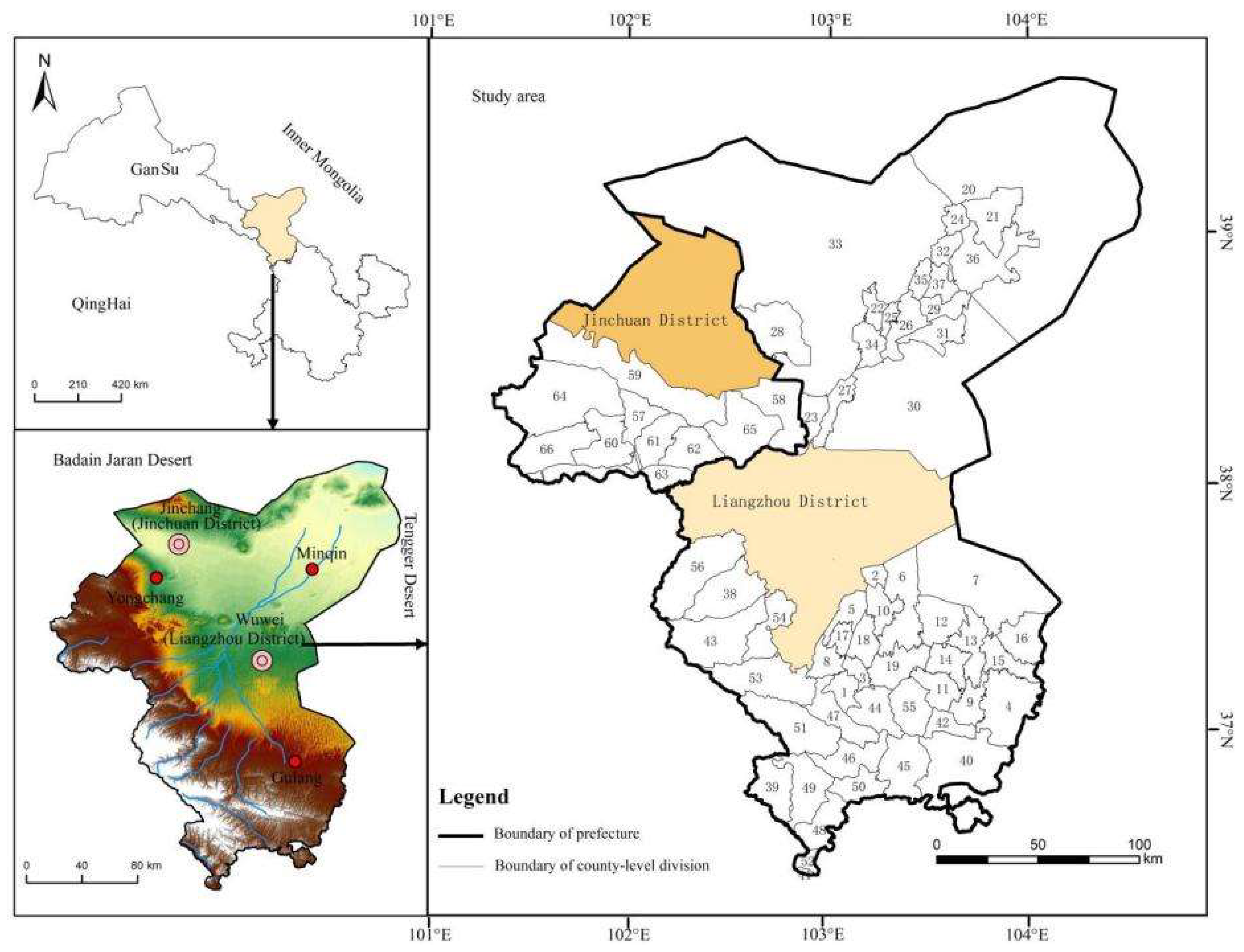
Figure 1. Location of the Shiyang River Basin, China. 1, Heisongyi Town; 2, Yongfengtan Town; 3, Shibalibao Town; 4, Xinbao Town; 5, Sishui Town; 6, Huanghuatan Town; 7, Haizitan Town; 8, Gufeng Town; 9, Gancheng Town; 10, Tumen Town; 11, Hengliang Town; 12, Xijing Town; 13, Dajing Town; 14, Minquan Town; 15, Peijiaying Town; 16, Zhitan Town; 17, Gulang Town; 18, Dingning Town; 19, Huangyangchuan Town; 20, Donghu Town; 21, Xiqu Town; 22, Daba Town; 23, Caiqi Town; 24, Hongshaliang Town; 25, Sanlei Town; 26, Suwu Town; 27, Chongxing Town; 28, Changning Town; 29, Dongba Town; 30, Nanhu Town; 31, Jiahe Town; 32, Quanshan Town; 33, Hongshagang Town; 34, Xuebai Town; 35, Datan Town; 36, Shoucheng Town; 37, Shuangcike Town; 38, Qilian Town; 39, Tiantang Town; 40, Songshan Town; 41, Dongping Town; 42, Dongdatan Town; 43, Maozang Town; 44, Duoshi Town; 45, Huazangsi Town; 46, Dachaigou Town; 47, Anyuan Town; 48, Saishisi Town; 49, Tanshanling Town; 50, Shimen Town; 51, Zhuaxixiulong Town; 52, Sailalong Town; 53, Haxi Town; 54, Dahonggou Town; 55, Xidatan Town; 56, Danma Town; 57, Chengguan Town; 58, Zhuwangbao Town; 59, Hexibao Town; 60, Jiaojiazhuang Town; 61, Dongzhai Town; 62, Liuba Town; 63, Nanba Town; 64, Hongshanyao Town; 65, Shuiyuan Town; and 66, Xinchengzi Town.
Preprints 76958 g001
Figure 2. Research framework
Preprints 76958 g002
Figure 3. Visual interpretation process of rural settlements (a) ZY1-02C, (b) ZY1-02D, (c) Landsat 5
Preprints 76958 g003
Figure 4. Distribution of rural settlements in the Shiyang River Basin in 2000, 2011 and 2019.
Preprints 76958 g004
Figure 5. Changes of rural settlements in the Shiyang River basin during 2000-2001 (a) and 2011-2019 (b)
Preprints 76958 g005
Figure 6. Average nearest neighbor coefficient of newly added rural settlements in the Shiyang River Basin from 2000 to 2011 (a) and 2011 to 2019 (b)
Preprints 76958 g006
Figure 7. Gravity centers of rural settlements in the Shiyang River Basin
Preprints 76958 g007
Figure 8. Relationship between rural settlements’ distribution and their distance from rivers in the Shiyang River Basin
Preprints 76958 g008
Figure 9. Relationship between rural settlements’ distribution and their distance from the nearest oasis margin in the Shiyang River Basin.
Preprints 76958 g009aPreprints 76958 g009b
Figure 10. Relationship between rural settlements’ distribution and their distance from traffic routes in in the Shiyang River Basin.
Preprints 76958 g010
Figure 11. Representative photographs of (a) abandoned rural settlements and (b) new rural settlements in the Shiyang River Basin.
Preprints 76958 g011
Figure 12. Abandoned rural settlements after population migration (Photo taken in Huanghui Village, Xiqu Town, Minqin County)
Preprints 76958 g012
Figure 13. Driving process of spatio-temporal evolution of rural settlements
Preprints 76958 g013
Table 1. Area and annual growth rate of rural settlements in the Shiyang River Basin from 2000 to 2019
Region Increased Area/km2
2000 2011 2019 2000-2011 2011-2019 2000-2019
Gulang 4.25 4.33 4.44 0.08 0.11 0.19
Jinchuan 0.59 0.60 0.66 0.01 0.06 0.07
Liangzhou 10.32 10.41 10.71 0.09 0.30 0.39
Minqin 7.61 8.48 8.62 0.87 0.14 1.01
Yongchang 3.67 3.69 3.76 0.02 0.07 0.09
Total 26.44 27.51 28.19 1.07 0.68 1.75
Table 2. Gravity center of rural settlements in the Shiyang River Basin
Region 2000 2011 2019
X (m) Y (m) X (m) Y (m) X (m) Y (m)
Liangzhou 818780.40 4202954.74 819337.81 4202812.45 819717.85 4202745.22
Jinchuan 789199.48 4269550.63 788945.43 4269448.90 788473.99 4269343.13
Minqin 878549.00 4301874.09 876054.53 4298522.33 870622.77 4291855.16
Gulang 880655.51 4154497.60 875948.48 4158946.55 876583.38 4158549.94
Yongchang 768804.37 4237775.52 768434.02 4238573.62 768961.17 4237577.37
Total 845513.25 4225374.97 844573.88 4226507.26 844429.09 4226321.74
Table 3. Moving distance for gravity center rural settlements
Region 2000-2011 2011-2019 2000-2019
Radian Distance   (m) Radian Distance   (m) Radian Distance   (m)
Liangzhou -0.250 575.29 -0.175 385.94 -0.220 960.58
Jinchuan 2.761 273.67 2.921 483.16 2.863 754.58
Minqin 2.211 4178.11 2.254 8599.72 2.240 12775.13
Gulang 3.899 6476.83 -0.558 748.61 3.925 5744.88
Yongchang 4.278 879.85 -1.084 1127.13 -0.901 252.69
Total 4.020 1471.22 0.908 235.34 -0.718 1439.37
Table 4. The relationship between number of rural settlements and distance from the nearest river
Year < 1000 (m) 1000–2500 (m) 2500–4000 (m) > 4000 (m)
Number Percentage Number Percentage Number Percentage Number Percentage
2000 2475 38.88 2038 32.01 1387 21.79 466 7.32
2011 2839 40.23 2235 31.67 1451 20.56 532 7.54
2019 2885 39.83 2265 31.27 1471 20.31 622 8.59
Table 5. Industrial economy and urbanization process in the Shiyang River Basin
Year GDP/102 million RMB Proportion of industrial structure /% Urbanization rate /%
First industry Second industry Tertiary industry
2000 98.70 27.9 43.3 28.8 21.94
2011 461.45 15.7 59.3 25.0 35.84
2019 828.76 20.3 35.7 44.0 48.86
Disclaimer/Publisher’s Note: The statements, opinions and data contained in all publications are solely those of the individual author(s) and contributor(s) and not of MDPI and/or the editor(s). MDPI and/or the editor(s) disclaim responsibility for any injury to people or property resulting from any ideas, methods, instructions or products referred to in the content.
Copyright: This open access article is published under a Creative Commons CC BY 4.0 license, which permit the free download, distribution, and reuse, provided that the author and preprint are cited in any reuse.
Prerpints.org logo

Preprints.org is a free preprint server supported by MDPI in Basel, Switzerland.

Subscribe

© 2024 MDPI (Basel, Switzerland) unless otherwise stated