1. Introduction. The role of UNESCO and ICOMOS in protecting the heritage of cities
In November 2011, the UNESCO world event on the historic cityscape culminated in the establishment of the 2011 UNESCO Recommendation on the Historic Urban Landscape (HUL). The convention brought together numerous municipality leaders and experts and presented 19 case studies from 39 countries. The event served as a promoter and diffuser of the in-depth HUL approach, recognizing nature within the global context of the historic urban landscape and considering it an instrument of integration. As a result, urban collaborations with the UNESCO World Heritage Centre have grown into the so-called World Heritage City Labs. This meant that, within the framework of the World Heritage Cities Programme, studies on relevant and present topics as sustainability, resilience, urban management systems and livelihoods have started to be promoted. City Labs are, in brief, international workshops that serve as common learning to develop strategies and proposals for the management challenges of World Heritage Cities based on the HUL Recommendation. After the 10th anniversary of the HUL Recommendation, between 2021 and 2022, a series of celebrations were organized, including the meeting days of Córdoba (Spain) “Laboratory Of World Heritage Cities, Urban Heritage And Traditional Construction Practices For Sustainable Development”. The objective is to improve plans based only on guiding parameters, urban zoning, and architectural conservation.
The HUL Recommendation provides a multi-layered perspective of Urban Heritage with the aim of drawing up a proposal for a holistic urban planning. The series of presentations exposed a mosaic of cases from around the world, including a wide range of interlinked issues that currently arise in historic cities with respect to sustainable heritage management. One of the presentations referred to a UNESCO report on Istanbul, which analyses the influence of urban development (Yenen, 2016) [
12], that, over the years, has become the seed of the study of other cities which are integrated in the World Heritage.
Türkiye is deeply committed to the protection of Cultural and Natural Heritage. As evidence of this, it has a very complete national legislation which is reflected in the various legislative instruments implemented over the past decades -Türkiye Law No2863 on the Protection of Cultural and Natural Assets” (Law Nº2863, at national level, as amended by the Laws No17.06.1987, No3386; No5226, dated 14.07.2004), “Environmental Law” (Law No2872), “National Parks Law” (Law No2873), “Bosphorus Law” (Law No2960), “Coastal Zones Law” (Law No36921/3830), “Decree Law on the Establishment of an Environmental Protection Institution” (Decree Law No383).
In the same line, in 1982, it joined the “1972 Convention on the Protection of the World Cultural and Natural Heritage” as a State Party (A country that is part of a specific agreement, to which it rigorously complies). It might be mentioned that the feature of major importance of the 1972 World Heritage Convention is that it establishes a connection between the notions of nature conservation and the preservation of cultural property. The Convention acknowledges how human beings interact with nature, and the fundamental necessity of maintaining a balance between both. In any case, as a result, during the 27th, 28th, 29th, 30th, 31st and 32nd sessions of the World Heritage Committee, progress reports on Istanbul as a World Heritage City were requested in response to comments and recommendations from UNESCO/ICOMOS. Successive inspection missions have confirmed the effective implementation of solutions (Debold-Kritter, [
6] A., Michelmore, D. Sorosh-Wali, A. J.) [
7]. As a result of this whole process, Istanbul is one of the world’s first cities with World Heritage value and has been the protagonist of a report by UNESCO on the proliferation of the built-up area, which is one of the major urban challenges facing us in this new millennium. The expansion of the urbanized land cover is damaging, not only because of its impact on Heritage, but also adds a side effect: an increase in road traffic. This development of the city, associated with the elongated shape of the urban plant and the land separation created by the Bosphorus, increases environmental and acoustic pollution, while devouring natural surfaces and degrading the historic built environment.
2. Materials and Methods
Constantinople is more than a city; it represents the layers of civilizations that have been overlapped over the time. Following the expansion pattern of the modern urban framework, the city has ended up gobbling up many natural spaces while the population has been increasing by leaps and bounds. Consequently, road traffic has also increased, which has led to serious threats like environmental and acoustic pollution that have endangered some historical sites of the megalopolis. The railway is one of the most important infrastructures for the current operation and mobility of this megalopolis, it is a transport system that crosses the metropolitan area in two well distinguished sections, namely Asian and European, on both sides of the Bosphorus. This article analyses, from a historical and geographical perspective, the construction of the Marmaray railway carried out since 2004 to the present and the proposals for the protection of the natural and cultural heritage affected by the construction works. The main purpose is not only to show the construction features of this railway line, but additionally to enforce the Marmaray as a sustainable development strategy for the city. To support that, a methodology has been proposed grounded on an in-depth bibliographic review of the subject matter and the first-person observation of Marmaray’s works. This methodological contribution is based on the work carried out from 2012 to 2017 related to the design and the execution of the previously mentioned railway infrastructure, which includes the historical constructions and the protected zones together with the archaeological findings.
3. Results
3.1. The turkish railway system and the Marmaray’s works
The Greek colonists of Megara founded Byzantium about 667 BC. However, the first human settlements were established in the region thousands of years previously, specifically during the Neolithic period. Its most relevant feature, and which has marked its fate throughout history, has been its key geostrategic location, like a bridge between Europe and Asia.
It is also crucial to note that the Bosphorus Strait, which runs through the enclave, is a part of another nexus, this one aquatic. It connects, via marine link, the Mediterranean, the Aegean, the Marmara, and the Black seas [
15]. All of these features combine to make it an incomparable place, bridging continents and oceans, extraordinary elements that give the keys to the uniqueness of the current city of Istanbul making us understand why it has been contested for ages by great civilizations and empires. Alongside this growth, authentic architectural jewels have been constructed, leaving a unique cultural context always accompanied by the natural richness brought by the Bosphorus, the region of Marmara and the Black Sea.
The Marmaray railway, named after the Marmara Sea and the Turkish word “ray” for rail, is one of the main elements that make up contemporary Istanbul. This railway infrastructure crosses the city longitudinally, being the route parallel to the sea that has originated its appeal. This article addresses certain issues and concerns about the construction of this iconic railway system and the preservation of the Heritage, particularly in relation to the Natural Heritage of the Turkish Megalopolis [
19].
3.1.1. The railway’s role in Istanbul’s urban growth
The English developed the first railway system in 1825 by constructing a line linking Manchester and Liverpool. After that, due to the popularity of steam locomotives, the aforementioned transport system was expanded by France (1832), Belgium (1834), Germany (1835), and later, other nations in continental Europe, at a time when the Industrial Revolution was just getting started (Sánchez-Blanco, 1994) [
11]. The Osman House (1299–1922), the dynasty in charge of the Ottoman Empire, which had Constantinople as its capital at that time, became mindful of all this scientific advancement. The sultan devised a geopolitical strategy and a financial plan after giving the thought to the benefits that this transportation system may provide and while simultaneously attempting to strengthen the kingdom's economy (Christensen, 2017) [
4].
As a result, the Ottoman railway network (1868-1919) took root, connecting Bosnia with Baghdad, Medina and Cairo. Later it rose to become the pride of the empire and its supreme symbol of modernization. However, although being predominantly German, the design and financing were managed by foreign corporations. This element exemplifies a colonial situation that was especially unclear, where the interests of the German and Ottoman governments were switching constantly. Throughout the 20th century, the Turkish railway system underwent numerous changes that affected the urban networks of the country’s main capitals. As a way to meet the changing needs of mobility and the continual growing population, it was necessary to knit together public transportation networks and update some of the existing routes.
The Sultan’s ambition to connect Asia and Europe was not realized until the 21st century, when the technology allowed for the construction of an underwater tunnel that would span the Bosphorus and be supported by the seabed [
13]. The Marmaray is the outcome of a novel railway system that runs longitudinally across Istanbul. It consists of three tracks, two for urban transit and one for intercity – and their matching structures, which cover both the surface of the land and bottom of the sea. Prior to 2011, the city was served by two urban transit rail networks only. While line B2 (Haydarpaşa-Gebze part) was on the Asian side, line B1 (Halkalı-Sirkeci section) was on the European side. They ran parallel to the Sea of Marmara and were not connected to each other because the Bosphorus was between them.
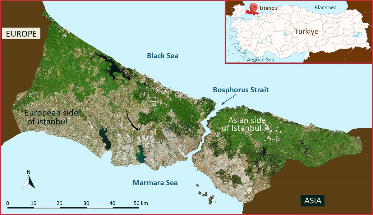
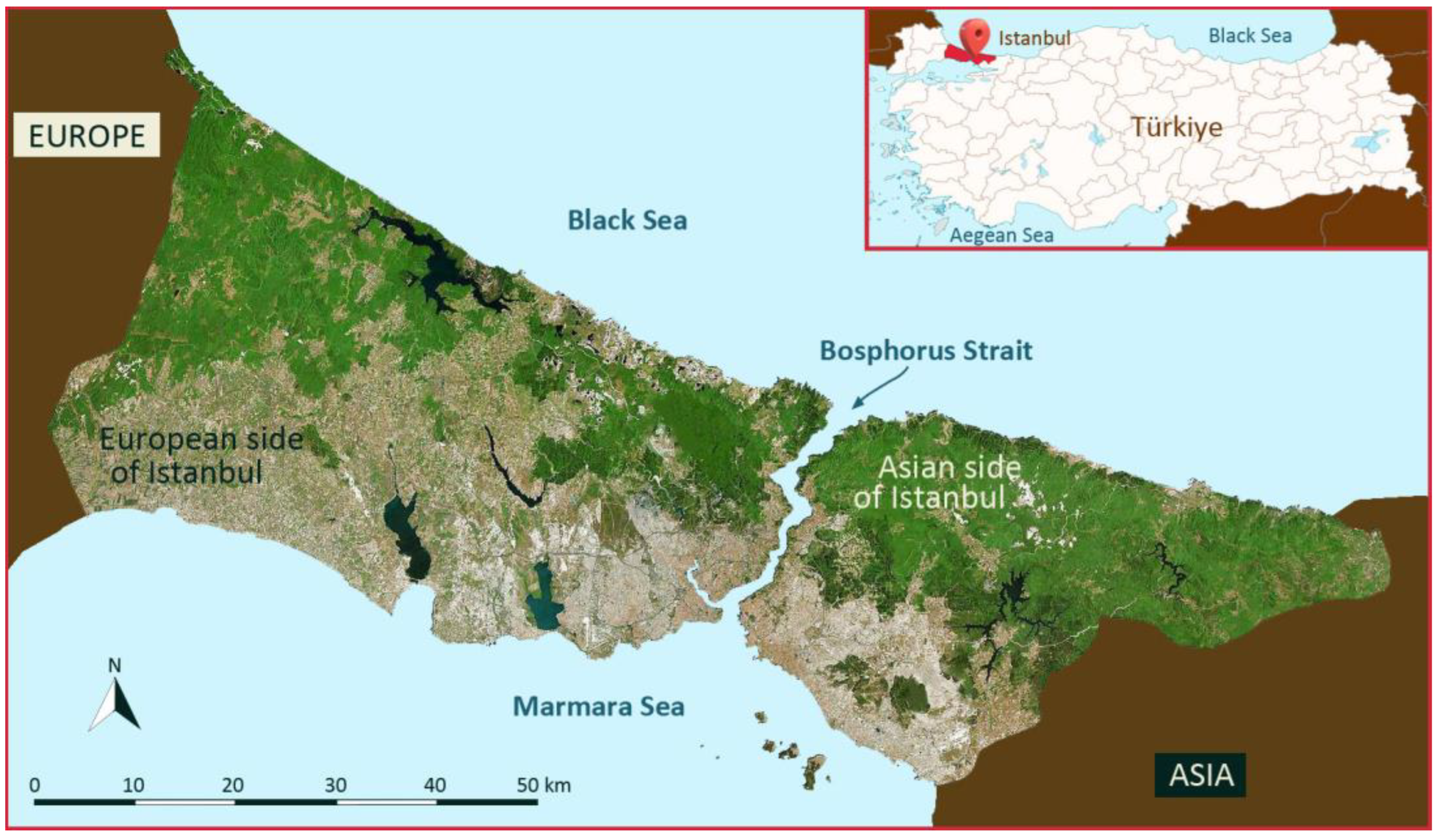
Figure 1.
Satellite image of Istanbul. Source: Own elaboration based on Karaman et al., 2017.
Figure 1.
Satellite image of Istanbul. Source: Own elaboration based on Karaman et al., 2017.
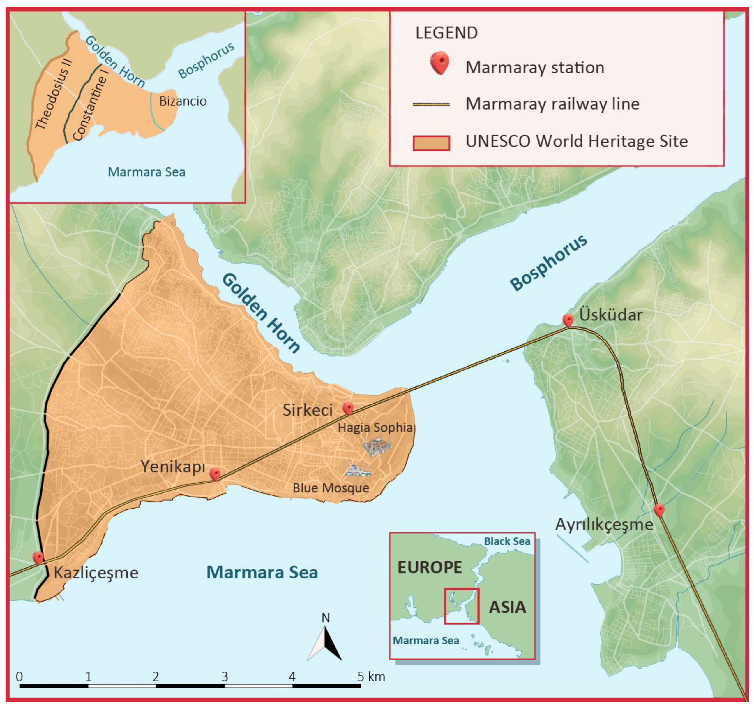
Figure 2.
Contour of the path of the Marmaray trail through Istanbul’s “Historic Peninsula”. Source: Own elaboration based on images by Alexander van Millingen, 1899.
Figure 2.
Contour of the path of the Marmaray trail through Istanbul’s “Historic Peninsula”. Source: Own elaboration based on images by Alexander van Millingen, 1899.
In order to determine the Marmaray’s path, scientists started their research in 1984. The works’ final tender was released in 2003 as part of a project that had three main components.
The initial step was to connect the B1 and B2 rail networks into one system in order to connect the two continents. This would manifest as a railroad tunnel that would traverse the Bosphorus and set on the seabed.
The second entails establishing a suburban railway line connecting Gebze (in Asia) and Halkalı (on the European side), as well as updating the entire current system to be compatible with modern technologies. In other words, as a means to upgrade the railway system, a new network had to be created because the old one was outdated.
Lastly, a third track was requested to establish a high-speed train system, which will ultimately be integrated into the Istanbul-Ankara line.
3.1.2. Marmaray’s works. A complex and lengthy construction process
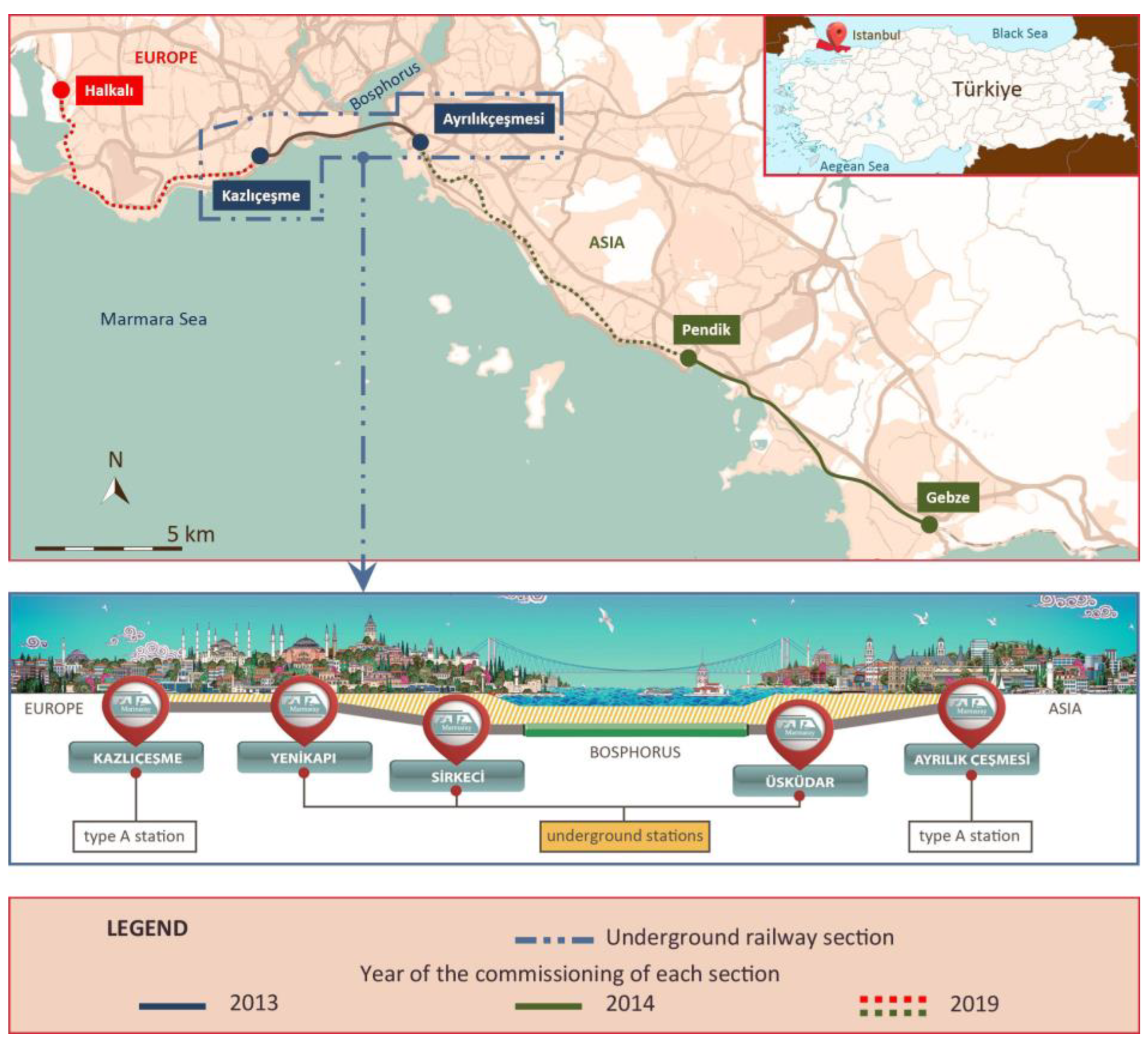
In the Marmaray’s works, the existing rails were taken out, a third track was added, new stations, substations, and depots and yards buildings were constructed, an underwater tunnel was built, and the complete electrification system was renovated. As will be explained below, all of these actions interacted with the city and its heritage. To begin with, the extra track required a bigger width than the previous one, which has a direct effect on nearby constructions throughout the entire railway network. Keeping in mind Istanbul's historical constructions, some of them were impacted and required dismantling, adaptation, or relocation, depending on the circumstance. In addition, other archaeological discoveries surfaced and a larger area of activity was required to locate the new tracks. The Marmaray railway project includes the construction of new stations by reason of the current ones for lines B1 and B2 lacked the space necessary to accommodate the facilities required by the new railway system. Besides, the buildings located in the depots and yards zones were new ones, so that they would be large enough to house today’s machinery and equipment. Likewise, new substations had to be built in order to supply electrical power to the railway system. Furthermore, stations that weren't there previously were added. In short, all of these constructions meant the need for a substantial area to build them in both, on the surface and their foundations, which occasionally resulted in the finding of archaeological artifacts, especially at the buried stations (
Figure 3).
On the other side, for the purpose to be positioned to adapt the new railway system to the width of the Marmaray’s three tracks, the historical stone bridges that crossed the former track had to be dismantled. Some of these structures were preserved in storage spaces, while others were reconstructed nearby using techniques approved by the Preservation Committee. Natural and Historical Heritage Preservation Committee Regional designates the Turkish state body which is a regional committee for the conservation of Natural and Historical Heritage.
As a result of the construction along the 76,3 km of the Marmaray railway (
Figure 3), numerous new buildings have been built such as 42 stations, 18 buildings of workshops and depots and yards, 176 structures (pedestrian crossings and/or road traffic, railway bridges, false tunnels, etc.), including 7 substations. What’s more, 57 historical constructions and plenty of trees have undergone various types of interventions (studied according to the case and after the project's approval by the Preservation Committee) [
20].
We start to imagine the impact generated when we understand the scale of the construction works, especially taking in account that they happen to be located in a metropolis with centuries of history. At this point, it is clear how several challenges have accompanied the development of the railway system since its very beginning, when the Ottomans implemented the first locomotive framework, notably in the territory corresponding to the current city of Istanbul. Such difficulties are mostly related to location (
Figure 4), which implies the necessity for modern technology, as well as financial issues, sophisticated geopolitical tactics, etc. However, the works of Marmaray railway continued and have meant a before-and-after strategy to achieve a sustainable city. Moreover, they have presented new challenges and defiance for Heritage, an aspect that will be detailed in the next chapter.
3.2. Istanbul’s frenetic urban growth, which poses a danger to its natural heritage
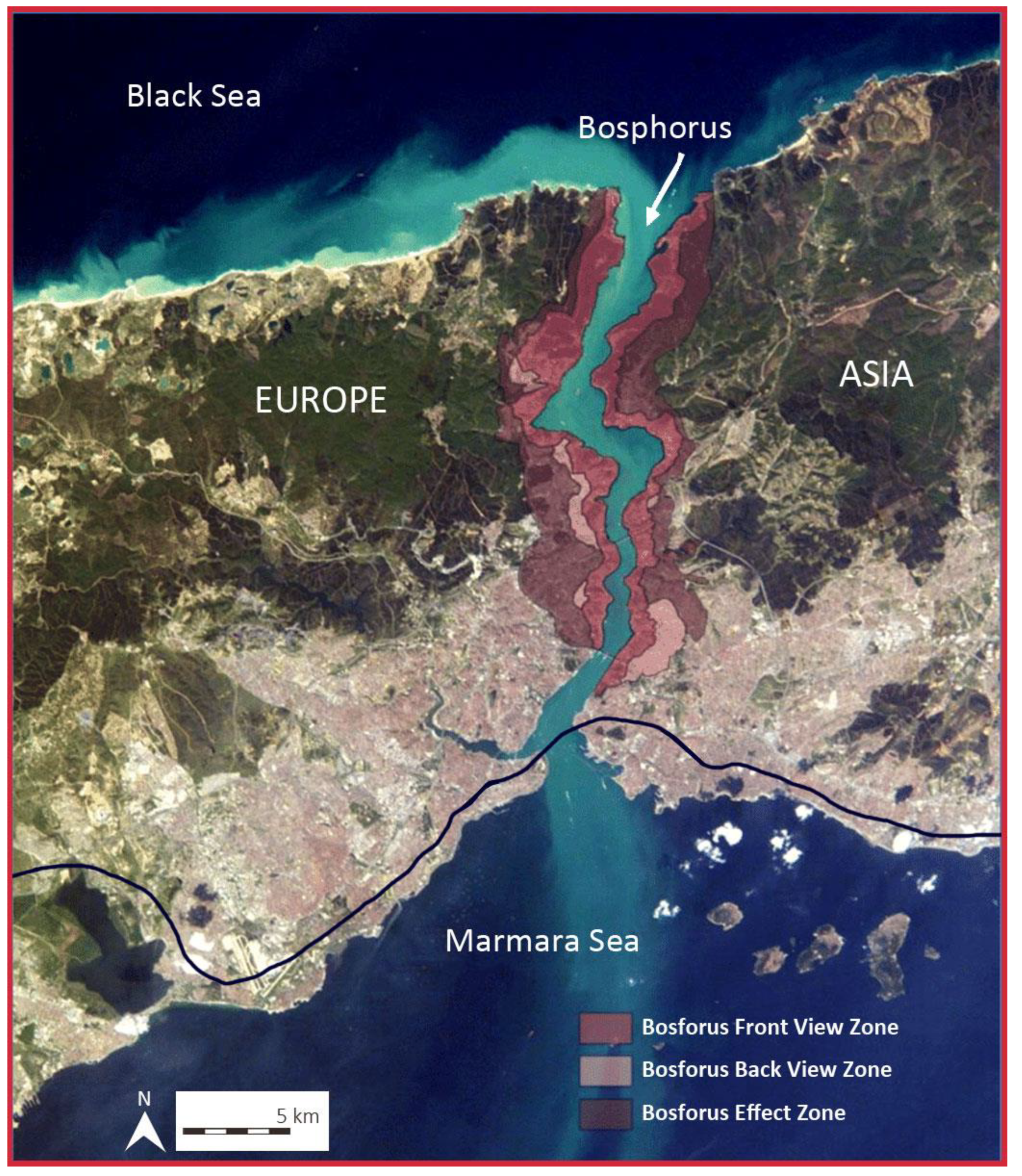
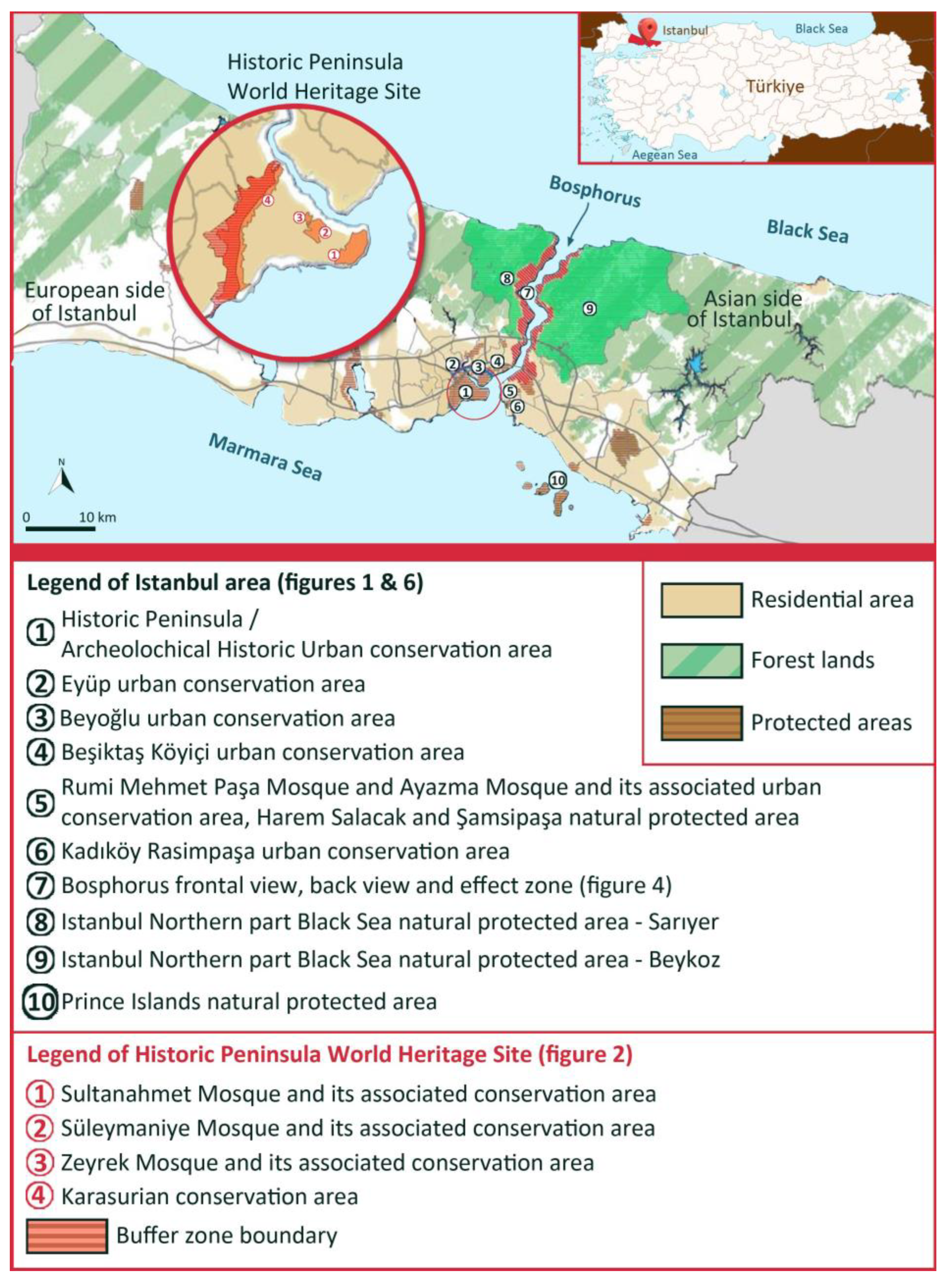
Due to its natural, historical, and aesthetic, the Bosphorus Area of Istanbul, which is situated in a region bridging Asia and Europe, has a special charm. The spatial development of this land (
Figure 4) is characterized by a unique topographic morphology, linked to ancient settlement patterns known as “Bosphorus Villages” along with groves. The biggest growth in these neighborhoods has been observed since 1950, according to the elements that have shaped its expansion throughout time (
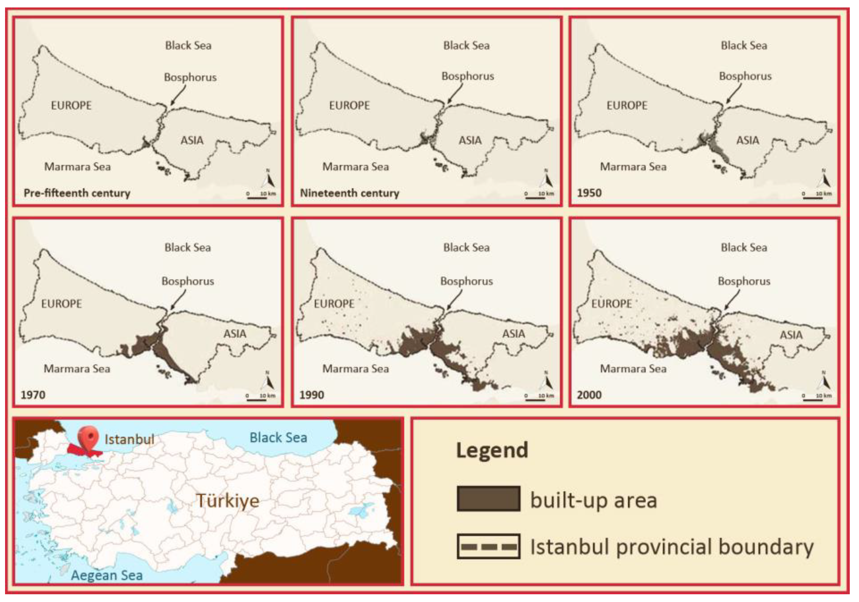
Figure 5).
The four phases listed below, which span from the middle of the 20th century to the present, could be identified within this framework of study (Yıldız et al., 2018):
1950-1980: is characterized by rapid urbanization, with the emergence of the industrial city, linked to squatter settlements (
gecekondu), and also the construction of the first bridge over the Bosphorus (Karpat, 2004) [
9] .
1980-1990: the industrial sectors are reorganized, resulting in a decentralization of industry, plus the construction of the second Bosphorus bridge;
1990-2000: there is an expansion out of downtown along the roadways.
▪From 2000: launch of transformation projects such as the construction of the third airport, the third bridge, the Euroasian Tunnel (road traffic tunnel) and the Marmaray rail network. As the population and underlying economic investments of the nation have always gravitated toward Istanbul, the entire city is vulnerable to development and the pressure of transformation in the Bosphorus Area (
Figure 4).
In that sense, the natural resources and historical assets are in danger as well. These locations are especially protected whereas there is a significant threat to the preservation of their natural environment and of their cultural identity [
18]. Considering all the above, the issue of regeneration and rehabilitation in Istanbul was elevated to the top of the political and planning agenda in 2000. In summary, this age is characterized by developments that emerge on the outskirts of the city that endanger natural zones (Yıldız et al., 2018).
Previously, all these difficulties had already been taken into consideration. Afterwards, the first integrated planning studies on the protection of the Istanbul Bosphorus Area started in 1970 (
Figure 4), when it was announced that the region was protected from both a natural and historical perspective. In this regard, the initial step was the establishment of the conservation organization GEEAYK (October 10, 1970).
The Plan for the Protection of Natural Historic Sites of the Bosphorus was subsequently put into effect in 1977 along with the related laws, and it underwent revisions in 1978, 1979, and 1982. The Bosphorus Act, numbered 2960 and dated 22.11.1983, came into effect in 1983 and marked the establishment of the first sector-specific protection code established in Türkiye (Yıldız et al., 2018).
Istanbul is the most populated metropolis in Türkiye (
Table 1), as well as its main economic core, being the center of industrial and financial development of the country.
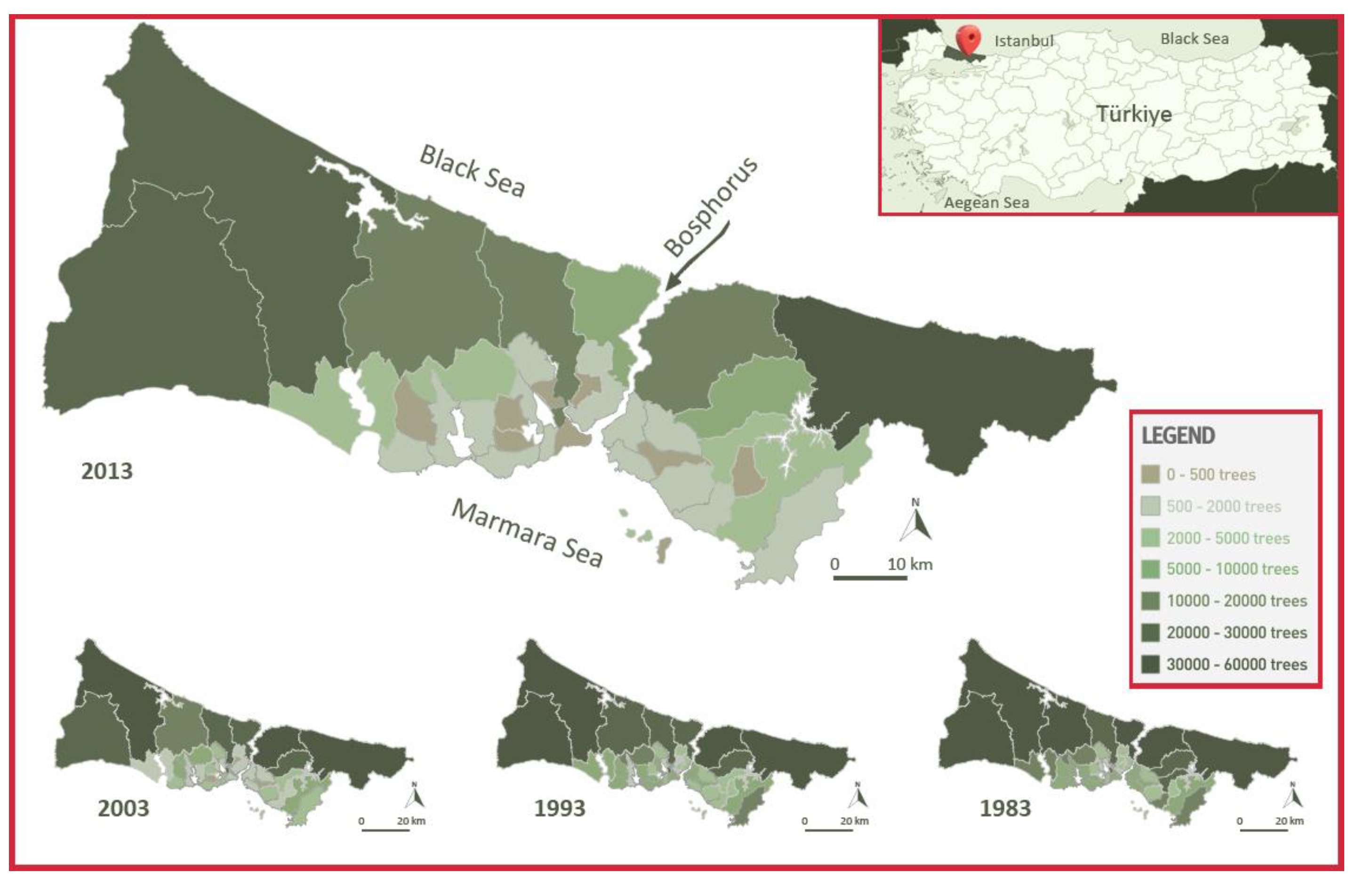
Beyond the great historical and cultural values, it possesses a unique location as a transition area between the Mediterranean and the Eurosiberian. In view of being situated at the confluence of several climates between Central Europe and the Mediterranean regions, studies of its geographical setting have revealed an immense potential for biodiversity and endemic habitats. Despite the city’s ideal position, urban growth has an impact on the richness and diversity of its plant life. As a result, there are two zones with different types of woodland. To put it another way, these two resulting areas, along with the rapid urbanization (
Figure 5), have been the main influences on the quantitative evolution of the number of trees and the arboreal type (
Figure 6) (Başer, 2011) [
2].
The 480,577-hectare megalopolis is distinguished by its sloping topography, which is created by hills, valleys, and basins. In terms of the seas, the Bosphorus Strait splits the city in two, with the Black Sea to the north and the Marmara to the south. The woodlands of the north, which make up 216,400 hectares or 40% of the land, are what most clearly define the region's green structure. On both sides of the Bosphorus, the built-up regions are growing along the southern shores (
Figure 7).
The city's four separate types of urban green spaces are habitat to over 2500 plant species, giving the area an exceptionally broad spectrum of biodiversity [
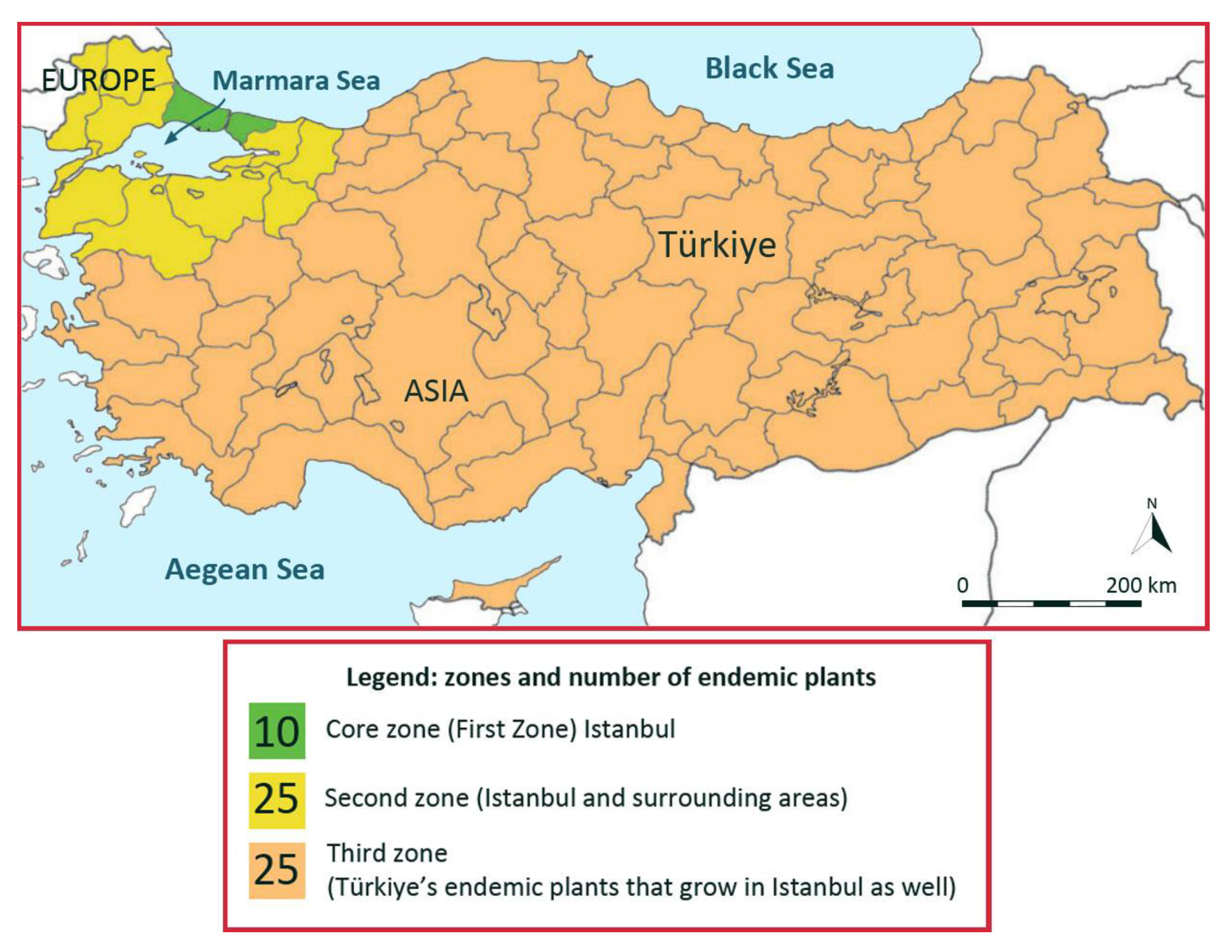
14]. The researchers have concluded their studies by stating that 10 of the 60 endemic plant species of Türkiye are only found in Istanbul. It means the plants have an extremely small geographic distribution region, along with urban growth, putting them at risk. Giving an overview of the country's species, half of them is endemic to Istanbul and its surroundings (adjacent cities), while the rest is distributed throughout Anatolia (
Figure 8), (Akalin and Tuncay, 2018) [
1].
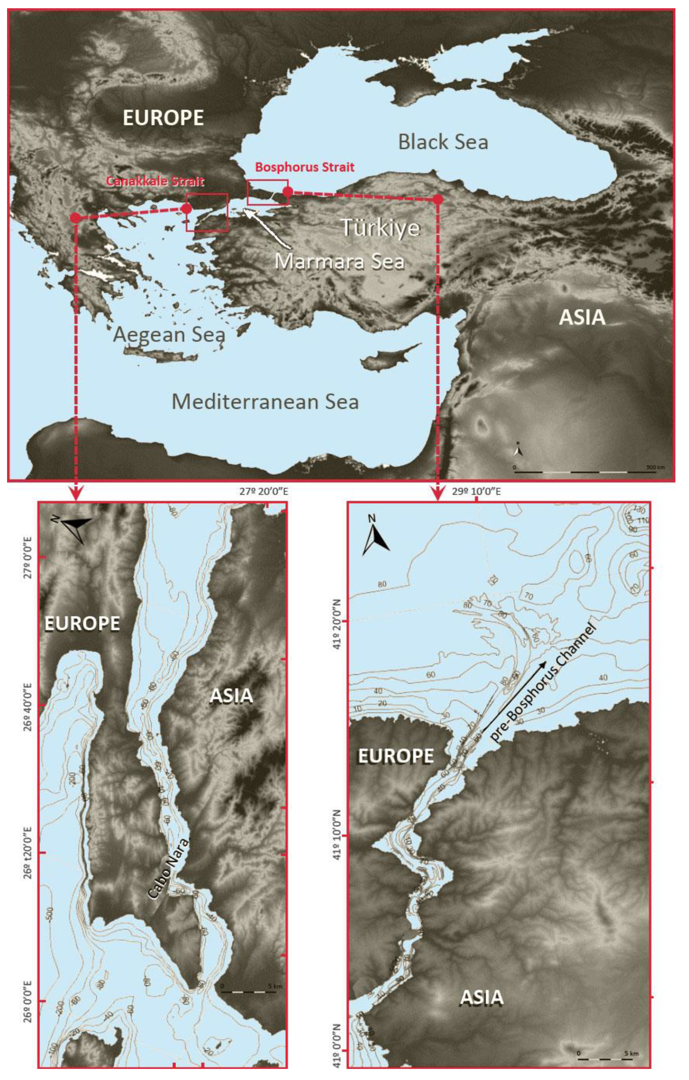
After characterizing Istanbul's terrestrial environment, the presence of aquatic life in the Bosphorus is investigated. It is hard to properly understand this strait without considering how the Black Sea, Marmara Sea, Aegean, and Mediterranean are connected to it. The Turkish Straits System (TSS) is the designation of this maritime artery that brings together species from various parts of the world. This system operates under the Bosphorus and the Dardanelles, two straits in the north of Türkiye, connecting the Black Sea to the Sea of Marmara in the northeast and the Sea of Marmara to the Aegean Sea, which opens to the Mediterranean Sea in the south, respectively (
Figure 9). Despite being a relatively straightforward maritime path, it poses a biogeographic and physiological barrier to marine life. Hence, the TSS regulates the local marine species, and it is unavoidably connected to the impact of human activity (Bayram and Temel, 2011) [
3].
On the one hand, there are biogeographic barriers along the migration path of Mediterranean species. Regarding these actual obstacles, the Nara Pass region of the Dardanelles Strait presents the first obstacle to Mediterranean fish larvae and plankton species. Only those species that can keep themselves within the narrow sub-halocline layer, which is located immediately below the interface, get the oxygen they require to survive and maintain their daily diet during their passage through the Sea of Marmara. Unfortunately, differences in level cause many species to sink into the resulting tufts, where they are unable to survive. Mediterranean species that successfully enter the Bosphorus also experience four simultaneous impacts, as in the case of the Dardanelles Strait (
Figure 9). The first is induced by the southern threshold, the second by the constriction region, the third along the channel before the Bosphorus and the fourth by the northern threshold at the way out to the Black Sea. As a result of these impacts, there is a further reduction in Mediterranean species migrating to the Black Sea. Besides these migratory difficulties, there are physiological obstacles. The lack of food in the bottom layer forces Mediterranean species to move towards the upper layer. Those heading into the top layer can undergo physiological collapse due to a sudden change in temperature (between 7 and 10ºC) and salinity (between 10 and 15psu). TSS additionally functions as a biological corridor for cetaceans and pelagic fish that migrate across the Black Sea and the Aegean. Their unique adaptation to the characteristics with respect to invertebrates enables them to easily survive in both the high salinity of the Aegean Sea and the low salinity environment of the Black Sea by overcoming variances in salinity and other physiological barriers. The expansion of the range of Mediterranean species may become further compromised by additional human-induced stress factors, which could significantly restrict migrations added to all these specific physical and physiological challenges. These human-induced impacts are depicted by the noise from heavy maritime traffic, oil spills, overfishing and chemical pollution.
4. Discussion. Marmaray as a strategy for combating atmospheric and noise pollution caused by road traffic in Istanbul
The time has come to determine whether the Marmaray railway system previously described has a destructive effect or, on the contrary, it can become a tool to support environmental conservation once we are aware of the flora and fauna, both terrestrial and aquatic, that could be affected by the implementation of the Marmaray in the area. As mentioned above, the rapid urbanization of Istanbul has colonized the space (
Figure 5), harming the local flora and fauna. Moreover, the city's green spaces have been speedily decreasing while on the reverse side, pollution from vehicles and boats has disturbed migratory fish routes from the Mediterranean and the Aegean to the Black Sea, impacting aquatic life in the Bosphorus. For the purpose of trying to make Istanbul a sustainable metropolis, the Marmaray was then envisioned as a solution to the concerns brought on by transportation. Together with the population growth anticipated for the future, which in recent years has averaged around 300,000 people per year, Istanbul's enormous total population—estimated at 15.5 million people—is the province in Türkiye with the highest population density, with 2,976 people per km2 (
Table 1). This factor automatically highlights and increases the demand for daily passenger transport. In brief, bus and car traffic began to be severely congested during the morning and afternoon rush hours, with the aggravating circumstances these bands tended to develop.
It should be noted that Istanbul is part of the group of cities that have experienced major expansion in the so-called Urban Age. The term Urban Age refers to “Istanbul And Urban Age Conference” which was held in November 2009. Urban Age is a project that is based on international research on certain cities, including Istanbul. This series of studies began in 2005 and aims to bring to light the problems, as well as the solutions, that each megalopolis has implemented “to the need to retain a clear Sands of identity and Collection in a fast-moving world” (Emden, 2009) [
7].
The rapid growth of its population over the past two decades has left the city with somewhat outdated transportation infrastructure, as well as severe congestion problems, which have generated emissions of noxious gases. Istanbul is the least polluting megalopolis around the globe, although it nevertheless accounts for more than 85% of Türkiye's emissions. The problem is complicated by the fact that the Bosporus separates the city in two parts.
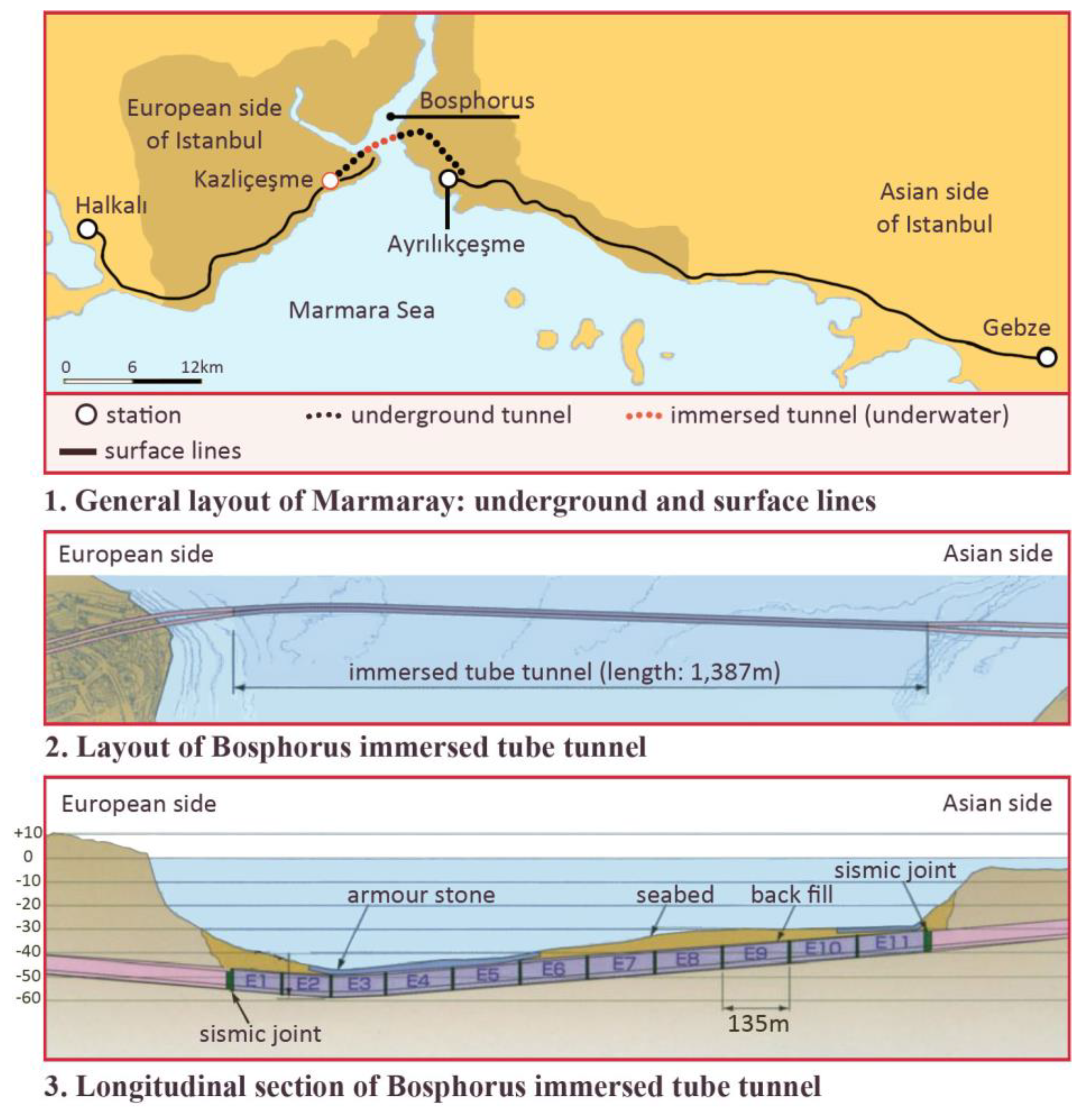
Figure 7 shows the zones most densely populated of Istanbul, which clearly corresponds to the urbanized area. Thus, threatened by overpopulation, traffic and pollution, the Turkish government devised a sustainable city that would have the Marmaray as the main axis of its urban transport, extending longitudinally to supply a large percentage of the population (
Figure 3). In a different arrangement of concepts, the population pyramid demonstrates that it is a young population, capable of traveling daily to study centers and workplaces by some form of transportation The Marmaray has been developed at street level for most of its route, except for the section between Kazliçeşme and Ayrılıkçeşme stations (
Figure 10), which consists of a buried and a submerged area. The surface sections are linked through a series of underground conduits, which in fact connect to the underwater tunnel beneath the Bosphorus. The typologies and general dimensions of buried tunnels are illustrated in
Figure 10. The Marmaray underground path traverses the historically densest zones of Istanbul in Asia and Europe and, therefore, the where the oldest buildings of the city are located, which have minimal foundations (
Figure 2). In these circumstances, it was essential to minimize the possibility of groundwater infiltration. As a way to accomplish this, firstly, the connection between the submerged and drilled tunnels was made underground as direct and continuous as possible, eliminating the need of using the usual intermediate wells and reaching the seabed level of the deep waters of the Bosphorus Strait. This was a constructive operation which required maximum control of the excavation in front of the tunnel to ensure its stability and minimize water infiltration. Based on these considerations, it was determined that using a tunnel boring machine (TBM) was the optimal method of tunnel excavation, since it uses a sludge shield and is capable of operating under high interstitial pressures, (Sakaeda, 2005) [
10]. Furthermore, there is the section of the submerged tube tunnel of the Bosphorus, which was first raised in 1860 as a bridge supported by piles. The tunnel was built in a sustainable way for the environment, on the grounds that it respects the seabed by resting on the seabed, preventing the harm that would come to aquatic ecosystems if it was buried (
Figure 10) [
16,
17].
Another benefit is that it was constructed at a time of year when aquatic animal migrations were not taking place. Adding a curiosity, this railway tunnel is 60.46 meters deep, making it the deepest submerged railway tunnel in the world. It is as well built to withstand earthquakes that measure 9 on the Richter scale (Ingerslev et al., 2020) [
8].
In summary, the Marmaray entire technological deployment has been beneficial in many ways. The first goal was to increase the number of people using the railway system. According to estimations, this would result in an increase of 3% to 27.7%, which would boost the line's capacity, which was previously 10,000–12,000 passengers per hour and per direction, to around 75,000. Estimating a time between trains of two minutes in the peak period. It was anticipated that the total number of daily passengers would gradually rise to 1.5 million. All this succession of improvements would be reflected in the same way in the manner of urban growth, decreasing the pressure to convert urban land into roads, crossroads and parking. In parallel, it would make it possible for the operation of freight train services, on both regional and international routes, outside peak hours, and international passenger transport between Europe and Asia. Moreover, it would significantly shorten the time needed to traverse Istanbul longitudinally. From a different perspective, it would result in a decrease in traffic on the roads, and similarly, this switch from road to rail systems would also be reflected in a decrease in accidents and related costs, being benefits associated with fewer hours lost in repairs and bureaucratic procedures, such as insurance and accident notification, including savings in medical treatment by accident, and so on.
Besides, the quality of the air would improve due to fewer vehicles on the road, thus reducing air pollution in the metropolitan area, which would imply a decrease in airborne diseases (savings in the release of greenhouse gas emissions are estimated to be 6,400 tonnes per year). When it comes to protecting the Natural Heritage, marine ecosystems would gain too because less traffic would be traveling on the Bosphorus and Sultan Fatih Mehmet bridges, which were both used to cross the strait near the Marmaray tunnel. Furthermore, this would have an effect on the number of ships that travel between continents. It would also encourage accessibility to bus networks, minibuses (dolmuş) and metro, as well as parking facilities, so that people may park their cars, or even leave them at home, and move around the city by public transportation. There is no doubt that this strategy is designed to be a much faster, safer and cleaner system.
In summary, Marmaray would be an environmentally sustainable public transportation system. This is demonstrated by the newly constructed building of the railway system, which are complemented by fleets of new trains, so that the Marmaray would be driven spine of a new public transportation network, which allows easy access, comfortable and fast to all points of the city, contributing to the protection of Cultural and Natural Heritage (Cürebal and Efe, 2011) [
5].
5. Conclusions
The Marmaray railway is part of a strategy to promote public transportation and everything that goes along with it. Its objectives include becoming an efficient and useful mode of transport that can serve a large number of passengers, cross the city longitudinally, and connect to other public transportation networks (such as the metro or buses). However, this longitudinal route of around 76 km, although supported by the existing Asian and European branches, has required more space than the previous railway system, leading to interactions with Heritage at ground and subsoil level. In 2015, with the UN’s approval of “The 2030 Agenda for Sustainable Development”, the opportunity arose to undertake a new path whose tools are the 17 Sustainable Development Goals (SDG). Specifically, Goal 11 aims to make cities more inclusive, secure, resilient and sustainable. In this regard, it is worth noting that the world is increasingly urbanized, resulting in a deterioration of air quality and uncontrolled urban growth. Based on more specific data, 3.5 billion people (nearly half of humanity) live in cities and the UN predicts that this number will rise to 5 billion by 2030. All of that leads to Goal 11. In relation to the topic of this article, between now and 2030, the intention is to "provide access to safe, affordable, accessible and sustainable transport systems for all and improve road safety, in particular through the expansion of public transport". In a similar vein, there is a need to reduplicate efforts to protect and safeguard the Cultural and Natural Heritage of the world.
The world population rose by one billion people over the past 12 years, according to studies given at COP 27. On November 15, 2022, the eighth billion inhabitant of the planet was born. Once more, this calls into question the effects of human overpopulation. The International Convention, Architectural Monuments in Conflicts and Disasters Prevention / Intervention / Recovery, which took place on 25 November 2022, addresses this subject as one of the highlights, without disregarding, of course, the effects of climate change, armed conflicts and other natural events and human disasters. Recapitulating, the UNESCO Recommendation of 2011 on the Historic Urban Landscape (HUL) was presented with a very complex picture, trying to turn cities into sustainable, from cities already consolidated and respecting their Heritage, where are we going taking in account that there have been 1 trillion more individuals added to the population of the Hearth in just over a decade? What scenario do we face with regard to the expectations for growth in the coming years presented at COP 27? As discussed at the recent meeting in Sharm El-Sheikh (Egypt), the goals would include redistributing the resources currently available to humanity and projecting sustainability as a fundamental challenge of the present and the future. In terms of biodiversity, there is now a worldwide concern. At the end of 2022, COP 15 took place in Montreal (Canada), a world congress organized by the United Nations whose purpose is developing strategies for achieving global agreements to safeguard biodiversity. The point is that in the coming years, a million species may vanish from the globe. For this reason, it is very important to establish a strategy. In the last 50 years the vertebrate population has decreased by 69% affecting ecosystems and this impact goes beyond, since 55% of the world’s GDP depends on biodiversity. It means that, if this trend continues, it will have catastrophic effects on both the environment and the economy.
All of these factors make it clear that the sustainable construction of railway infrastructure, such as the Marmaray, not only contributes to reducing the environmental impact caused by private traffic in megacities such as Istanbul, but they can be seen as preservation tactics for the Historical and Natural Heritage sites.
Funding
This research received no external funding.
Data Availability Statement
Not applicable
Conflicts of Interest
The authors declare no conflict of interest. “The funders had no role in the design of the study; in the collection, analyses, or interpretation of data; in the writing of the manuscript; or in the decision to publish the results”.
References
- Akalin, E.; Tuncaya, H.O. Endemism in Istanbul Plants. Istanbul University Press, 2018, 77, 39–41. [Google Scholar]
- Başer, B. Natural and Cultural Traces of the Flora of Istanbul. Turkish Academy of Sciences Journal of Cultural Inventory 2011, 9, 155–166. [Google Scholar]
- Bayram, Ö.; Temel, O. (2011): Mechanisms Impeding Natural Mediterranization Process of Black Sea Fauna. Black Sea-Mediterranean Environment 2011, 17, 234–253. [Google Scholar]
- Christensen, P.H. Germany and the Ottoman Railways: Art, Empire, and Infrastructure; Yale University Press: London, United Kingdom, 2017.
- Cürebal, I.; Efe, R. Impacts of the Marmaray Project (Bosphorus Tube Crossing, Tunnels and Stations) on Transportation and Urban Environment in Istanbul, In Engineering Earth-The Impacts of Mega engineering Projects, Stanley D. Brunn Editions, ,2011,41, pp. 715–733.
- Debold-Kritter, A.; Michelmore, D.; Sorosh-Wali, A.J., World Heritage 33 COM, United Nations Educational, Scientific And Cultural Organization, Convention Concerning The Protection Of The World Cultural And Natural Heritage World Heritage Committee. In UNESCO World Heritage Centre/ICOMOS Joint Reactive Monitoring Mission Report Historic Areas of Istanbul (Turkey) (C 356) from 27 to 30 April 2009. Thirty-third session, Sevilla, Spain, (20 – 30 June 2009). 30 April.
- Emden, C. Urban Footprint, In Istanbul City of Intersections, Urban Age, The London School of Economics and Political Science, 2009, pp:19-34.
- Ingerslev, L.C.; Iversen, C.; Özgür, Ö. Marmaray (Bosphorus Crossing), Tunnelling and Unde ground Space Technology,2020, 122. 122.
- Karpat, K.H. The Genesis of the Gecekondu: Rural Migration and Urbanization (1976), European Journal of Turkish Studies, 2004, 1.
- Sakaeda, H. Marmaray project: Tunnels and stations in BC contract. Tunnelling and Underground Space Technology, 2005, 20, 612–616. [Google Scholar] [CrossRef]
- Sánchez-Blanco, V. Desarrollo de las líneas férreas en Europa: aspectos históricos. La red de transportes ferroviarios españoles, Cuadernos de estrategia, 1994, 71, 23–30. [Google Scholar]
- Yenen, Z. Paisaje Cultural Histórico de Estambul, Número especial. Patrimonio Mundial en Turquía, Revista Patrimonio Mundial, World Heritage Convention UNESCO 2016, 80, 23–39. [Google Scholar]
- Gülal, E. Document details Marmaray bosphorus crossing project: Surveying activity and geodetic monitoring, Yildiz Technical University, Department of Geomatics Engineering, 2014, Istambul, 21,1, 1-7.
- Oniz, H. Yernikapi - settlement and burials below sea level. In Oceans of Archeology, Anders Fisher and Lisbeth Pedersen Editors, 2018, pp.104-105.
- Özyılmaz, P.; Senlier, N. y Yıldız, R. Planning Process of the Istanbul Bosphorus Area, Conflicts and Challenges, Fifth International Symposium Monitoring of Mediterranean Castal Areas: Problems and Measurements Techniques, Conferencia en Livorno Italy (june, 2018).
- Sakaeda, H. Marmaray project: Tunnels and stations, In BC contract, Tunnelling and Underground Space Technology, 2005, 20/6, pp:612-616.
- Yavuz, E. Yavuz, E. Istanbul (Bosphorus) Immersed Tube Tunnel and Survey Works, International Journal of the Physical Sciences, 2011 6, 2303-2307.
- Altinyildiz, N. The Architectural Heritage of Istanbul and the Ideology of Preservation, Architectural Heritage of the “Lands of Rum”, 2007, 24, 281–305.
- Arias, J.L. Technical Explanation of the Railway Section in Goztepe Old Station – Bridge Area, Marmaray CR3 Contract, 2014, Istambul.
- Belkaya, H.; Karamut, I. y Ozmen, I.H. The Marmaray Project: Managing a Large Scale Project with Various Stake Holders, Proceedings of the World Congress on Engineering (WCE),2008, London, Unitad Kingdom (2-4 july 2008).
|
Disclaimer/Publisher’s Note: The statements, opinions and data contained in all publications are solely those of the individual author(s) and contributor(s) and not of MDPI and/or the editor(s). MDPI and/or the editor(s) disclaim responsibility for any injury to people or property resulting from any ideas, methods, instructions or products referred to in the content. |
© 2023 by the authors. Licensee MDPI, Basel, Switzerland. This article is an open access article distributed under the terms and conditions of the Creative Commons Attribution (CC BY) license (http://creativecommons.org/licenses/by/4.0/).
