Submitted:

10 July 2023

Posted:

11 July 2023

You are already at the latest version

Abstract
Space syntax can be potentially applied for the evaluation of quality of user flows particularly in solving problems of sustainable projects in spaces intended for users to move around. This study aims to analyze the concepts of pedestrian flows (open and closed) by space syntax based bibli-ographical approach on a global scale, demonstrating the capability of improvements in Sus-tainable Development Goals (SDGs) as applied to the architecture of sustainable flows. Scopus theoretical reference bases were used, which are directly related to the theme of space syntax in open and closed spaces. Frequency analyzes were carried out, applying the content analysis, to identify words with a degree of similarity, related to “space syntax: flow in urban environ-ments” and “space syntax in closed built systems”, in relations to the SDGs. The results show that pedestrian flows identified in the literature aid to understand the global production on space syntax in open and closed spaces, directed to user flows in the built environment, where many environments of flows in the built space analyzed become unsustainable because they do not present full flow efficiency. In our study on space syntax, the following central terms were identified: pedestrian movements (open urban systems) and space (closed built systems), which allows a better understanding of the flows, highlighting the importance of the urbanist architect on the functionality of user flows in sustainable architectural projects on a global scale. The most frequent categories for open environments were the terms space and form and for closed envi-ronments were space and flow.
Keywords: 
Subject: 
Social Sciences  -   Geography, Planning and Development

1. Introduction

Society’s built environment necessitates segregated spaces used by individuals traveling via different modes of transit [1,2]. Therefore, the need for conscious planning around routes that are suitable for the displacement of users, such as streets, public routes, variations in the topographic difference, among others, is of utmost importance. Effective urban design considers economic, social, technical and political aspects related to quality and comfort in both pedestrian and traffic flows [2,3].
The dynamics of pedestrian flows can be understood through the use of Space Syntax, through the application of the following analytical factors [4,5,6,7,8]: a) Space analysis: when referring to social interactions, with two topics: - represented in a non-linear context, b) buildings and common spaces between them, as well as the interior of a residence [5,6,7,8]; - Analysis of the visibility graph: using it to study an object, which represents different behaviors [4]; - Analysis of the agents: based on virtual individuals (called agents) implanted in the virtual environments, where they move around tracing paths and diversified routes so that, at the end of the simulation analysis, the circulation area with greater flow is evident [5,6,7,8]. The result of these movements enhances the construction of a synthesized map, where the integration and connectivity flows are displayed. These flows are represented by a color scale, generalized by representing a flow index which is represented through the color red (with maximum flow intensity) and blue (with lower flow intensity) [4].
There have been some studies related to the flow of built environments with the use of Space Syntax for the evaluation and improvements in the functionality of paths allocated in architectural projects [8,9,10]. The applicability of Space Syntax in the area of architecture and urbanism has enhanced its importance. When attributed to the allocation of spaces and environments in the design phase, the use of Space Syntax affords designers a greater design functionality, in relation to the flow of environments [8,10]. These functional aspects can be applied through the Theory of Space Syntax, created in London in 1970 by Bill Hillier and collaborators from University College London. The book “The social logic of space” was co-authored by Hillier along with Julienne Hanson, and published by the university [11] with the aim of analyzing the functioning of public and private spaces based on quantitative metrics present at different scales of the architectural project. It also presents important aspects of the urban system with universal accessibility focused on natural displacement patterns
The forms of representation of human movements in the built environment through the analysis of Space Syntax are understood as a set of movements related to individuals, with the aim of providing the natural mobility of users [12]. This concept can be understood through the ability of people to move along paths in the built environment [12,13]. The resulting pedestrian flow through a design can be adequately predicted utilizing Space Syntax, thus providing information on the daily needs of individuals in walking urban routes or built environments [9,13].
Easy mobility within a given area or space enables individuals to engage in increasing social interaction in these spaces intended for pedestrian movement [14,15]. By maintaining consistently active pedestrian movement, a space can be designed that allows for rapid transit and ease of transit with safety and attractiveness to passers-by [14,15]. Importance is placed on effective, rapid, and easy pedestrian movement which are considered important in maintaining the quality of life of users and in the better organization of public spaces [16,17].
Yang et al. [18] highlights the urban fabric as a way of representing the configuration of the urban design. It involves different pedestrian routes that make up the structure of the environment without neglecting the consideration of both positive and negative points aimed at the accessibility of individuals. This is applied to both open spaces (public walkways) and closed/restricted spaces (internally built systems). The need for this study, using the Theory of Space Syntax in a bibliographical way, is justified as the association between the design of an environment and the efficiency with which pedestrians flow through it, is well documented [19]. Notably, Space Syntax has stood out for predicting results based on the natural movement of people, for several decades [20]. The circulation of users reflects on the form of urban mobility in relation to the different routes chosen and utilized by users [20,21].
The general objective of this study is to analyze predicted pedestrian flows through both open and closed built environments using Space Syntax. Our goal is to utilize this tool to suggest improvements aimed at Sustainable Development Goals (SDGs) attributed to architectural design projects around sustainable flows. In order to accomplish this, a bibliographical analysis of the following perceptions was performed: Space Syntax: flow in urban environments and Space Syntax in closed built systems. The Space Syntax in open spaces deals with the analysis carried out in paths, through a direct analysis of the urban project aimed at user circulation in virtual spaces [22,23,24,25,26,27,28]. The Space Syntax in closed spaces deals with the analysis of the flow of users in internal environments of buildings, attributed to a direct analysis of the efficiency of flows in the architectural design of a given space [5,6,7,8].
This study can be classified as qualitative and quantitative, through the theoretical references reached in this literature review, based on the Scopus database between 2019 and 2022, which are related to the subject of Space Syntax in open or closed spaces. Thus, a frequency analysis was carried out, applying the Content Analysis Method (CAM) [29,30], to identify the terms that were necessary to attribute the degree of similarity by frequency (were repeated) between Space Syntax studies identified in the literature.
Tanaka et al. [7], Soltani et al. [27], Yildirim and Çelik [28] highlight the need to carry out further studies utilizing Space Syntax globally, since there is serious lack of dissemination of knowledge of the techniques of application of Space Syntax currently. This demonstrates the importance of this study for other researchers in the area of architecture and urbanism, with the possibility of analyzing the intensity of flows by simulation in the design phase of the architectural project is so valuable for both open and closed built environments on a global scale.
According to Dawodu et al. [31], sustainability can be incorporated into this debate from the perspective of architectural design focused on sustainability, reflecting on the ideas of optimizing spaces for more adequate user flows. This situation aims to make the process from design to construction economically viable and provide comfort and well-being to users [31]. However, sustainability in architecture faces conflicts in conceptual design and understanding of user flows as they reflect sociocultural contexts in global discourse [28,31].

2. Space Syntax: Flow in urban environments

The diverse natural forms of pedestrian displacement have enhanced the analysis of the studies recorded in the Scopus database. A total of 1,986 existing metadata files were returned when utilizing the search term: Urban Space Syntax. However, only seven of the returned files were characterized as being studies related to the topic addressed in this study [22,23,24,25,26,27,28], the utilization of Space Syntax in the evaluation of flows in environments with open paths aimed at pedestrian activities (Figure 1).
Koohsari et al. [22], utilized Space Syntax to analyze natural movements of individuals, and showed the importance of pedestrian displacement in certain urban spaces by enhancing pedestrian circulation in relation to that displacement. Such pedestrian movements, when successful, can lead to improvements in the quality of life of users [22]. In view of this, when analyzing walks as a relevant factor for urban mobility, using both Space Syntax and the Dephmath software, requires further investigations in relation to representation by simulation in the urban displacement of individuals [22]. Dephmath is a software used in the areas of urban design, architecture, urbanism, transport and geographic sciences, among others. The use of these two technologies together enhances improvements to be attributed in future urban projects, capable of solving possible problems that users face when moving through the built environment as pedestrians.
Tannous et al. [23], when discussing accessibility in the context of green areas in a metropolitan region of Doha, Qatar, used Space Syntax to evaluate the spatial configuration of public sidewalks through the use of flow analysis over displacement of people. The importance of green spaces aimed at accessibility in open environments was highlighted in this study. The authors also emphasized the importance of spaces that address challenges related to accessibility, highlighting the importance of Space Syntax for the delineation of routes with greater pedestrian integration [23].
On the other hand, El-Darwish [24], focused on an analysis of social interaction within a university space, examining the efficiency of pedestrian movements on certain routes. The increase in integrality, interaction and quality of life stands out when related to the importance of displacement carried out in open spaces. This study highlighted how improvements in landscaping and leisure spaces will increase user satisfaction by increasing positive social interactions between and the wellbeing of individuals who use these spaces [24]. Through the results of El-Darwish [24], it is possible to model pedestrian routes with a greater and more efficient flow of users, enabling the design of new spaces for walking, while at the same time enhancing the comfort and quality of life of users.
Garau and Annunziata [25] applied Space Syntax analyze open public spaces in the Villanova district, in Cagliari, Italy. They sought a connection between the forms of environmental displacement through the application of analytical methods defining the quantitative characteristics of urban space and pedestrian movements. These pedestrian movements have potential relation to the quality of life of users, through social activities [25]. The results of Garau and Annunziata [25] demonstrate that by studying the displacement relations between users, it is possible to quantify pedestrian circulation movements and guarantee an understanding of the integrality of the circulation spaces among users.
Gharaibeh et al. [26] used Space Syntax to analyze urban environments, through the use of new tools capable of aggregating quantitative pedestrian mobility indices aimed at universal accessibility in relation to the public transport system. The results demonstrate the importance of demarcating the analytical points (pedestrian paths), in addition to the efficiency of using different software (Gravity Model; Weighted Overlay) along with Space Syntax to carry out new research. Furthermore, this study demonstrated Space Syntax’s applicability when determining how best to encourage the public’s use of public transport (bus, train, among others) [26].
Soltani et al. [27], employed Space Syntax to carry out urban analyses using a road radius of 400 to 800 meters in order to verify the daily pedestrian displacement of individuals within a given path. The study highlighted the influence open space has on pedestrian movements within the urban fabric. Their findings were consistent with those of Garau and Annunziata [25], showing that pedestrian movements cause greater interaction between and among users
Yıldırım and Çelik [28] applied Space Syntax for analyzing the behavior of pedestrians in certain areas in the Besiktas region of Istanbul. The authors sought solutions for future projects to enhance the urban fabric of the city based on an analysis of pedestrian displacements and daily paths taken by virtual individuals. Through these, it was possible to highlight the importance of pedestrian displacements in public spaces, where certain types of infrastructure can lead to changes in the paths pedestrians utilize, in addition to impacting the best location of urban roads [28].
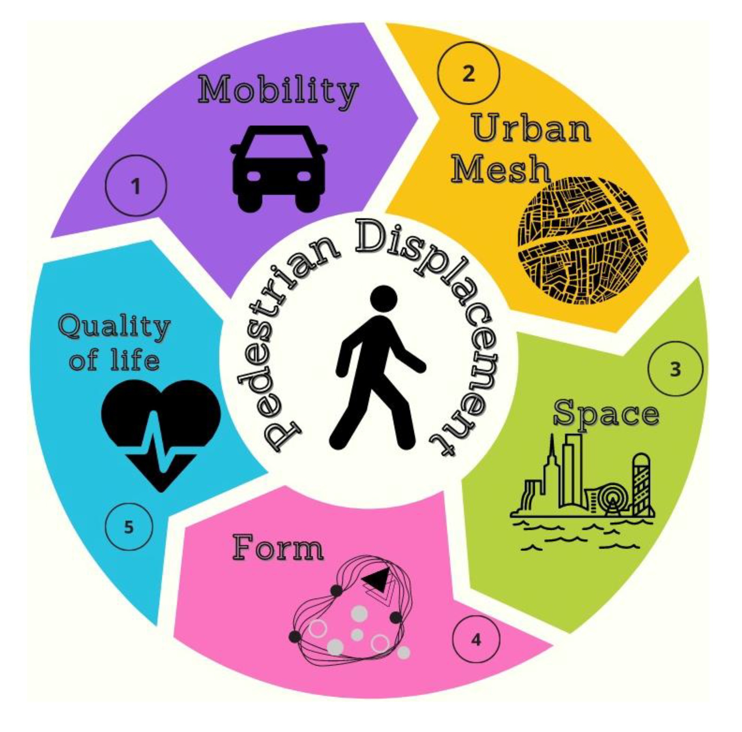
By applying the CAM to identify the assigned frequencies, Table 1 presents the concepts of the studies by Koohsari et al. [22], Tannous et al. [23], El-Darwish [24], Garau and Annunziata [25], Gharaibeh et al. [26], Soltani et al. [27] and Yildirim and Çelik (2022). These studies utilized Space Syntax in open environments along with MAC to reveal the following terms of greatest frequency: pedestrian trips; mobility; urban mesh; space; form; quality of life.
Based on the five categories of analysis determined a priori based on the literature [29,30] in relation to open environments, the frequency was presented by enumeration. In this context, the following frequencies of terms by numerical repetitions were considered: mobility= 16; quality of life= 21; urban mesh= 30; shape=46; and space= 79. These categories are interconnected and play an important role in the development of cities. Furthermore, adequate urban planning becomes fundamental to create sustainable projects for environments that are more accessible to population displacement [24]. Considering the highest number (frequency), the intelligent use of space when reaching a frequency of 79 becomes compatible with mobility, quality of life and sustainability of the built environment. In relation to the creation of adequate infrastructure, this ensures universal accessibility for pedestrians [25].
By observing the factors integrated into a space, after analyzing the studies of Koohsari et al. [22], Tannous et al. [23], El-Darwish [24], Garau and Annunziata [25], Gharaibeh et al. [26], Soltani et al. [27] and Yildirim and Çelik [28], the topics are highlighted in relation to pedestrian movements when analyzed in different highlighted perceptions (Figure 2). These include: Mobility (1) represents a form of displacement and path that users utilize/take in a space [32]; Urban mesh (2) is defined by an occupied area designated as within an urban perimeter, represented by blocks with lots and streets, and composed of urban solids and voids [33]; Space (3) is defined as an area that encompasses a group of dwellings, horizontal and vertical buildings, for industrial, leisure, social or cultural use [34]; Form (4) is the way in which an object is found in a given space in relation to the concept and design guidelines, based on the conception presented by an architectural project [35]; Quality of life (5) is a measure of perception an individual has regarding their overall quality and way of life [36,37].
The terms pedestrian movement, mobility, urban fabric, space, form and quality of life were identified and presented in studies by Koohsari et al. [22], Tannous et al. [23], El-Darwish [24], Garau and Annunziata [25], Gharaibeh et al. [26], Soltani et al. [27] and Yildirim and Çelik [28]. Measuring and modeling pedestrian displacement is the main reason for carrying out studies utilizing Space Syntax in open environments (spaces not enclosed within buildings). This technique makes it possible to predict the best layout of walking paths in an analysis of the space to be developed in the urban fabric, in order to increase quality of life for all users.
Despite the importance of studying open spaces (streets, roads and pedestrian paths) through Space Syntax, Tanaka et al. [7] and Zerouati [8] have shown that there is also a need to apply Space Syntax to development plans of closed environments (areas within buildings).

3. Space syntax in closed built systems

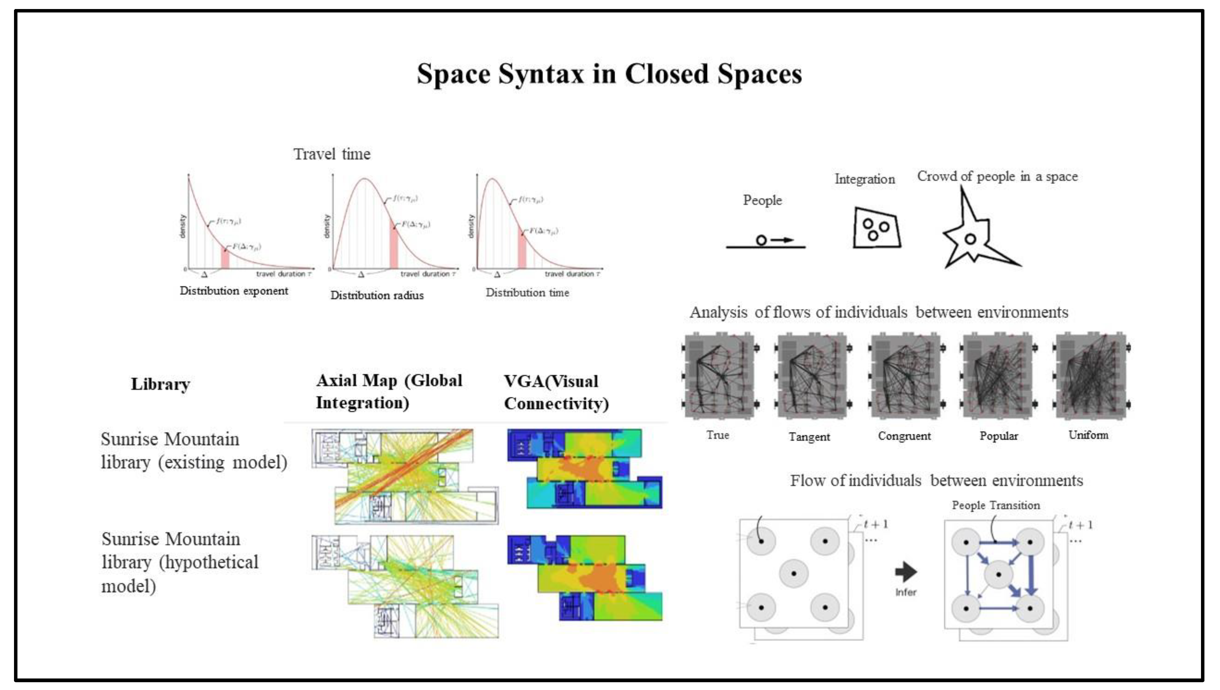
Patterns of pedestrian movement in the built environment gave rise to studies, based on Scopus, identifying a total of 454 metadata files, each of which included the following search terms: space syntax and indoor environments (space syntax; indoor environments). Among these, four files constitute this screening, as they are studies that address flows in internal built systems, considering the potential of pedestrian flow using Space Syntax [5,6,7,8] (Figure 3).
Alitajer and Nojoumi [5] question residential privacy in their study, which encompasses the pedestrian movements of individuals within the space configuration of traditional and modern houses in the city of Hamedan, Iran. Using Space Syntax as an analytical form aimed at verifying movements, quantitative comparisons were carried out using Dephmath software [5]. The influence on the projection of new buildings in relation to the integration between the existing built environment was necessary in order to predict the displacement of individuals between and within the two (new construction and existing infrastructure) [5]. The results recommend the analysis of Space Syntax in the initial phase of the architectural project. This allows for possible design changes in order to improve the functionality of the building's flows [5].
According to Askarizad and Safari [6], when analyzing the function of semi-open spaces in an effort to understand the behavior of individuals in relation to pedestrian movements within a public library of Sunrise Mountain and Desert Broom Libraries (Arizona, United States), it is possible to obtain data capable of aggregating projections to be applied in future public buildings.
From this, Space Syntax is used as an analytical method [6], and the importance of pedestrian displacements in built systems is highlighted where it enabled the identification of perceptions of insecurity of users who move in the building [6]. Space Syntax, in addition to identifying the areas of greatest flow, made it possible to adjust security in periods of intense user movement.
According to Tanaka et al. [7], using quantitative statistical methods and models of people flow spread to identify possible displacement data within a built system, through collection points in order, makes it possible to analyze the flow of people in relation to at the time of entry and exit from the building. This study utilized a shopping mall with exhibition halls. The use of Space Syntax for data analysis in relation to the enclosed pedestrian flows within this building made it possible to understand the displacements necessary to carry out expansion projects [7].
Zerouati [8] uses the analysis of Space Syntax in historical buildings, at an archaeological site located in Setif, Algeria. The objective of their study was to investigate the likely quality of life in relation to the flow and pedestrian displacement that took place within this built environment. The results indicate the relationship between the internal spaces of the historic building and the quality of life those pedestrians would have likely experienced based on projected broad flows and internal displacements [8].
Based on the analysis represented in the literature [38], it was possible to carry out the frequency analysis, through the use of MAC (which has five stages) in order to identify the following main points: 1) Problem; 2) Possibilities; 3) Explore data; 4) Test fundamentals and 5) Present the solution. Therefore, the use of CAM is presented and attributed to data researched in the literature [38].
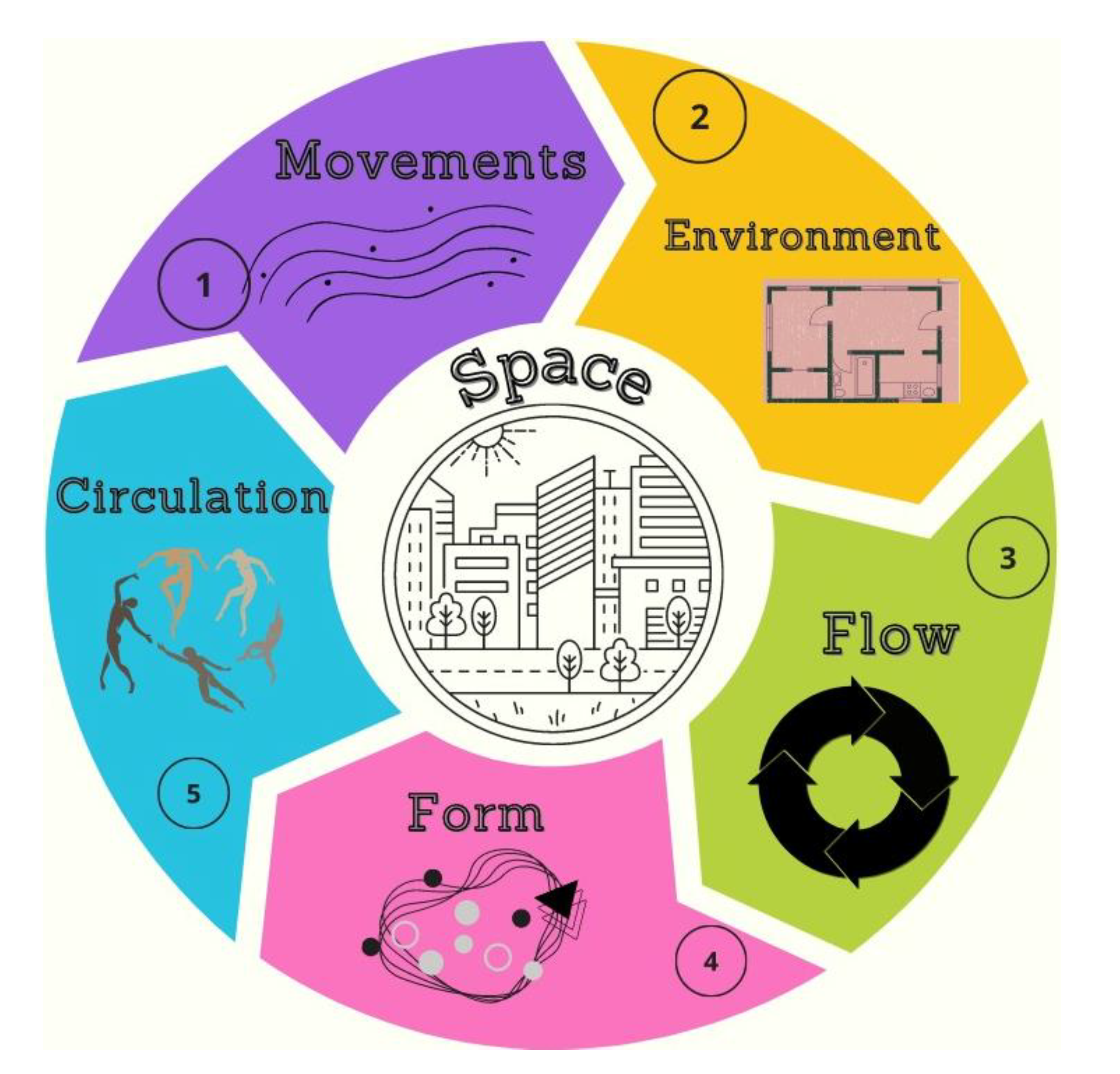
By assuming the frequency analysis by MAC from Alitajer, Nojoumi [5], Askarizad and Safari [6], Tanaka et al. [7] and Zerouati [8], the following terms resulting from the analysis were identified: space, movements, environment, flow, form and circulation (Table 2). It was possible to highlight from the terms identified by frequency, the following conceptions of Space Syntax in studies in built environments with closed characteristics: Space is the built environment, where studies of flow and circulation movements take place by Space Syntax in the initial phase of conceiving the form of the architectural project.
The seven categories of indoor analysis were presented by repetitive frequency numbers [38]. Such categories were used a priori based on the literature and the frequency established in the final compiled data [29,30]. These are the following terms in relation to their frequencies: circulation= 14; moves= 30; movements= 31; shape=46; environment= 52; flow=76; space= 79. It is important to reiterate that the most latent points (space and flow) are fundamental for building more efficient, inclusive and sustainable cities [39,40].
The space configuration of the city determines how people move, interact and use the different spaces available [6]. Proper planning for the implementation of projects in urban space can influence flows, facilitating mobility which is capable of contributing to a more functional and sustainable city [5].
When analyzing the different aspects that integrate the internal environments of a building and, incorporating the studies of Alitajer and Nojoumi [5], Askarizad and Safari [6], Tanaka et al. [7] and Zerouati [8], the following points are noted in relation to the internal movement of pedestrians within the space (Figure 4): Movements (1): are considered pedestrian movements over short distances and take place along different paths and routes [41]; Environment (2): it is a space formed to relate individuals to their social environment, conceived in either a material or immaterial way [42]; Flow (3): it is a form of movement related to the physical state of individuals that are in the same place and trace different paths, causing varied flows [7]; Form (4): is the way in which an object interacts in space, in relation to its design concepts and guidelines, based on the architectural concept [35]; Circulation (5): includes the possibility of movement in relation to individuals, being able to move around in the environment [43].
Alitajer and Nojoumi [5], Askarizad and Safari [6], Tanaka et al. [7] and Zerouati [8] emphasize the need to carry out studies utilizing Space Syntax worldwide applied to flows in built internal spaces. This study focused in the area of architecture and urbanism, but did not bibliographically identify other studies highlighting internally built spaces with applications of Space Syntax in the Scopus database. In summary, other research recognizes the importance of using other bibliographic databases with Scopus, as they are aimed at understanding pedestrian movements and highlighting the central idea of relevance when attributed on a daily basis to flows occurring on urban roads [43,44].
According to Yiannakoulias and Scott [44] and He et al. [45], the concept of greater relevance in pedestrian displacement comes closer to guaranteeing pedestrian safety by public authorities, as fear of accidents, marginalities, lack of lighting, conservation and maintenance generate certain perceptions for users. Therefore, it is necessary to constantly evaluate pedestrian paths in order to stimulate public policies capable of subsidizing urban architects in an effort to design and create urban projects that will contribute to the quality of life of users when moving around in the environment [45,46,47].
Another central theme in this study was the term “Space,” identified in Alitajer and Nojoumi [5], Askarizad and Safari [6], Tanaka et al. [7] and Zerouati [8] as considering the evaluation of flows in built environments through Space Syntax. According to Tanaka et al. [7], the assessment of flow space symbolizes a concern that designers acquire about the possibility of improving architectural projects in a sustainable way. When a building is constructed, the identification of the quality of pedestrian flow (both internal and external) is attributed to the efficiency of existing points of access. Enabling alternatives will improve the mobility of users throughout the building based on changes in the use of architectural compartments of functionalities established in the design phase of the project [48,49].

4. User flows in open and closed spaces, with the UN SDGs

The advancement of initiatives on Sustainable Development Goals (SDGs) have been growing on a global scale. However, these initiatives depend on the understanding of and interaction between local authorities, themes, benefits and actions in a positive and effective way. The scope of displacement spaces that enhance greater accessibility of user flows in open and closed environments depend on these [50]. The SDGs require advances in tackling problems arising from the implementation of future architectural projects capable of interconnecting private and public areas of the urban environment [51].
There is a connection between actions carried out and the disclosure of those actions. The global news on different topics with a focus on the 2030 Agenda, with 2.5% contemplating the goals in different topics, attribute the need for discussions that will improve urban flows on a global scale [52]. Consequently, both Space Syntax studies in environments with closed flows [5,6,7,8] and in urban spaces with open pedestrian flows (streets and public spaces) [22,23,24,25,26,27,28], emphasize the importance of applying improvements to architectural projects aimed at sustainability and effectivity of pedestrian flows in the urban environment. The flow of users in open and closed spaces is not widely mentioned in the SDGs. Additionally, many objectives aimed at the sustainability of the built environment are related to the flows of pedestrian users [53,54].
One of the objectives most related to the flow of users in open spaces is SDG 11 (Sustainable Cities and Communities) [55]. SDG 11 targets making cities and human settlements inclusive, safe, resilient and sustainable. This includes a number of specific targets that may be relevant to user flow, such as creating safe and accessible public spaces, and reducing accidents related to traffic with an emphasis on greater safety in the pedestrian movements of users. Also, increasing planning capacity with more sustainable urban management [50].
To promote the safe and sustainable flow of users in open and closed spaces, it is important that governments and communities work together to achieve these goals, creating policies and practices that promote the safety, accessibility and sustainability of cities and communities [50,54,55]. Urban displacement plays an important role in global development trajectories worldwide, as recognized by the 2030 Agenda [55].
In the dimension of an architectural project, sustainability aimed at displacement in open and closed flows starts from the urban analysis of the built system. In the sense of valuing sustainable use with integrated and detailed planning of the urban process of pedestrian flow, the architectural product is the result of multidisciplinary actions in compliance with norms and legislation [56]. These principles share support for sustainable architecture projects that improve the flow of users in both open and closed spaces. Raising awareness, guiding and clarifying the functioning and benefits of these spaces, studies utilizing Space Syntax, all allow for a marked increase in sustainable architectural design [57].

5. Conclusions

The analysis of the conceptions of pedestrian flows examined utilizing Space Syntax, identified in the literature, allowed for a better understanding of pedestrian flow within both open and closed spaces. This study highlighted the importance that some international architects attribute to the evaluation of flows through the simulation of pedestrian flows in the environment, using Space Syntax. The Space Syntax analysis method could become widespread by architects and urban planners on a global scale, which would enable a better assessment of pedestrian flows through the built environment in the design phase of urban and architectural projects.
The literature consulted analyzing open spaces, yielded terms with the frequencies space= 79 and shape= 46, presenting a higher frequency in the flows. This attributed the idea of central preference, when focused on the evaluation of urban roads, in the favor of the quality of life of users. In closed spaces, the literature has shown that the central term corresponds to space = 79 and flow = 76, making it possible to evaluate flows in circulation areas within the built environment. Space Syntax is capable of solving problems and enabling improvements that can be made during the design phase of an architectural project.
This study reinforces the importance of applying Space Syntax in open and closed environments on a global scale. Regarding future research, we suggest that teams examine the application of Space Syntax based on the literature presented in this study, in addition to the use of other databases. Such research should consider the constructed environment and public use aimed at the displacement of users. In conclusion, we highlight the importance of the architect and urbanist in pondering a better functionality of pedestrian flows in the urban environment, capable of overcoming project difficulties with greater sustainability around the social demands related to the displacements of users.

Author Contributions

Conceptualization, G.d.V.M., L.D.M. and P.W.d.L.L.; data curation, A.N.; formal analysis, C.C.O.d.A.S. and A.N.; funding acquisition, B.W.B.; investigation, P.W.d.L.L.; project administration, C.C.O.d.A.S. and A.N.; supervision, D.P.J. and G.d.V.M.; visualization, A.N.; writing—original draft preparation, A.E. and A.N.; writing—review and editing, M.S. and A.N. All authors have read and agreed to the published version of the manuscript.

Funding

This research received no external funding.

Institutional Review Board Statement

Not applicable.

Informed Consent Statement

Informed consent was obtained from all subjects involved in the study.

Data Availability Statement

Not applicable.

Acknowledgments

The authors are grateful to the Air Centre for supporting this research and the National Council for Scientific and Technological Development (CNPq) for the research productivity grant in Brazil. The authors also extend their thanks to the Center for Studies and Research on Urban Mobility (NEPMOUR+S/ATITUS), and Fundação Meridional, Brazil.

Conflicts of Interest

The authors declare no conflict of interest.

References

  1. Vaughan, L. The spatial syntax of urban segregation. Prog. Plan. 2007, 67(3), 205-294. [CrossRef]
  2. Rafiei, S.; Gifford, R. The meaning of the built environment: A comprehensive model based on users traversing their university campus. J. Environ. Psychol. 2023, 87, 101975. [CrossRef]
  3. Wang, L.; Han, X.; He, J.; Jung, T. Measuring residents’ perceptions of city streets to inform better street planning through deep learning and space syntax. ISPRS J. Photogramm. Remote Sens. 2022, 190, 215–230. [CrossRef]
  4. Hillier, B. Can Streets Be Made Safe? Urban Des. Int. 2004, 9, 31-45. http://dx.doi.org/10.1057/palgrave.udi.9000079.
  5. Alitajer, S.; Nojoumi, G.M. Privacy at home: Analysis of behavioral patterns in the spatial configuration of traditional and modern houses in the city of Hamedan based on the notion of space syntax. Front. Archit. Res. 2016, 5(3), 341-352. [CrossRef]
  6. Askarizad, R.; Safari, H. Investigating the role of semi-open spaces on the sociability of public libraries using space syntax (Case Studies: Sunrise Mountain and Desert Broom Libraries, Arizona, USA). Ain Shams Eng. J. 2020, 11(1), 253-264. [CrossRef]
  7. Tanaka, Y.; Iwata, T.; Kurashima, T.; Toda, H.; Ueda, N.; Tanaka, T. Time-delayed collective flow diffusion models for inferring latent people flow from aggregated data at limited locations. Artif. Intell. 2021, 292, 103430 . [CrossRef]
  8. Zerouati, W. Using space syntax analysis in archaeological site: Case of Cuicul (Djemila) in Setif, Algeria. Digit. Appl. Archaeol. Cult. Heritage, 2022, 26, e00234. [CrossRef]
  9. Hegazi, Y.S.; Tahoon, D.M.; Abdel-Fattah, N.A.; El-Alfi, M.F. Socio-spatial vulnerability assessment of heritage buildings through using space syntax. Heliyon, 2022, 8(3), e09133. [CrossRef]
  10. Xu, Y.; Chen, X. The spatial vitality and spatial environments of urban underground space (UUS) in metro area based on the spatiotemporal analysis. Tunn. Undergr. Space Technol. 2022, 123, 104401. [CrossRef]
  11. Hillier, B.; Hanson, J. The Social Logic of Space. Cambridge: Cambridge University Press, 1984. 296p. [CrossRef]
  12. Arslan, H.D.; Ergener, H. Comparative analysis of shopping malls with different plans by using space syntax method. Ain Shams Eng. J. 2023, 14(9), 102063. [CrossRef]
  13. Alalouch, C.; Al-Hajri, S.; Naser, A.S.; Hinai, A.A. The impact of space syntax spatial attributes on urban land use in Muscat: Implications for urban sustainability. Sustain. Cities Soc. 2019, 46, 101417. [CrossRef]
  14. Li, W.; Chen, M.; Yao, N.; Luo, Z.; Jiao, Y. Spatial-temporal evolution of roadway layout system from a space syntax perspective. Tunn. Undergr. Space Technol. 2023, 135, 105038. [CrossRef]
  15. Neckel, A.; Da Silva, J.F.; Saraiva, P.P.; Kujawa, H.A.; Araldi, J.; Paladini, E.P. Estimation of the economic value of urban parks in Brazil, the case of the City of Passo Fundo. J. Clean. Prod. 2020, 264, 121369. [CrossRef]
  16. Nadrian, H.; Heizomi, H.; Shirzadi, S.; Moradi, M.H.; Hajibadali, P. Exploring the dimensions of urban quality of life associated with urban traffic jam: The development and validation of an instrument. J. Transp. Health, 2022, 26, 101463. [CrossRef]
  17. Cappello, C.; Giuffrida, S.; Trovato, M.R.; Ventura, V. Environmental Identities and the Sustainable City. The Green Roof Prospect for the Ecological Transition. Sustainability, 2022, 14(19), 12005. [CrossRef]
  18. Yang, Y.; Tang, R.; Xia, M.; Zhang, C.A surface graph based deep learning framework for large-scale urban mesh semantic segmentation. Int. J. Appl. Earth Obs. Geoinf. 2023, 119, 103322. [CrossRef]
  19. Kuhle, A. Clues to the puzzle: The significance of material cultures in nonhuman primates for the study of language. Lang. Sci. 2018, 67, 72-88. [CrossRef]
  20. Virág, D.; Wiedenhofer, D.; Haas, W.; Haberl, H.; Kalt, G.; Krausmann, F. The stock-flow-service nexus of personal mobility in an urban context: Vienna, Austria. Environ. Dev. 2021, 41, 100628. [CrossRef]
  21. Chatziioannou, I.; Nikitas, A.; Tzouras, P.G.; Bakogiannis, E.; Alvarez-Icaza, L.; Chias-Becerril, L.; Karolemeas, C.; Tsigdinos, S.; Wallgren, P.; Rexfelt, O. Ranking sustainable urban mobility indicators and their matching transport policies to support liveable city Futures: A MICMAC approach. Transp. Res. Interdiscip. Perspect. 2023, 18, 100788. [CrossRef]
  22. Koohsari, M.J.; Oka, K.; Owen, N.; Sugiyama, T. Natural movement: A space syntax theory linking urban form and function with walking for transport. Health Place. 2019, 58, 102072. [CrossRef]
  23. Tannous, H.O.; Major, M.D.; Furlan, R. Accessibility of green spaces in a metropolitan network using space syntax to objectively evaluate the spatial locations of parks and promenades in Doha, State of Qatar. Urban For. Urban Green. 2021, 58, 126892. [CrossRef]
  24. El-Darwish, I.I. Enhancing outdoor campus design by utilizing space syntax theory for social interaction locations. Ain Shams Eng. J. 2022, 13(1), 101524. [CrossRef]
  25. Garau, C.; Annunziata, A. Public Open Spaces: connecting people, squares and streets by measuring the usability through the Villanova district in Cagliari, Italy. Transp. Res. Procedia, 2022, 60, 314-321. [CrossRef]
  26. Gharaibeh, A.A.; Tawil, H.S.; Alomari, A.I. Developing an indicative spatial accessibility analysis tool for urban public transportation system. Case Stud. Transp. Policy, 2022, 10(1), 175-186. [CrossRef]
  27. Soltani, A.; Javadpoor, M.; Shams, F.; Mehdizadeh, M. Street network morphology and active mobility to school: Applying space syntax methodology in Shiraz, Iran. J. Transp. Health, 2022, 27, 101493. [CrossRef]
  28. Yıldırım, Ö.C.; Çelik, E. Understanding pedestrian behavior and spatial relations: A pedestrianized area in Besiktas, Istanbul. Front. Archit. Res. 2023, 12(1), 67-84. [CrossRef]
  29. Ahmad, N.; Aghdam, R.F.; Butt, I.; Naveed, A. Citation-based systematic literature review of energy-growth nexus: An overview of the field and content analysis of the top 50 influential papers. Energy Econ. 2020, 86, 104642. [CrossRef]
  30. Armann-Keown, V.; Patterson, L. Content analysis in library and information research: An analysis of trends. Libr. Inf. Sci. 2020, 42(4), 101048. [CrossRef]
  31. Dawodu, A.; Cheshmehzangi, A.; Sharifi, A.; Oladejo, J. Neighborhood sustainability assessment tools: Research trends and forecast for the built environment. Sustain. future, 2022, 4, 100064. [CrossRef]
  32. Vantsevich, V.V.; Gorsich, D.; Paldan, J.R.; Ghasemi, M.; Moradi, L. Terrain mobility performance optimization: Fundamentals for autonomous vehicle applications. Part I. New mobility indices: Optimization and analysis. J. Terramech. 2022, 104, 31-47. [CrossRef]
  33. Gao, W.; Nan, L.; Boom, B.; Ledoux, H. SUM: A benchmark dataset of Semantic Urban Meshes. ISPRS J. Photogramm. Remote Sens. 2021, 179, 108-120. [CrossRef]
  34. Yang, L.; Duarte, C.M.; Ciriquián, P.M. Quantifying the relationship between public sentiment and urban environment in Barcelona. Cities, 2022, 130, 103977. [CrossRef]
  35. Alzahrani, A.A. Understanding the role of architectural identity in forming contemporary architecture in Saudi Arabia. Alex. Eng. J. 2022, 61(12), 11715-11736. [CrossRef]
  36. Shrestha, K.; Ojha, S.P.; Dhungana, D.; Shrestha, S. Depression and its association with quality of life among elderly: An elderly home- cross sectional study. Neurol. Psychiatry Brain Res. 2020, 38, 1-4. [CrossRef]
  37. Moro, L.D.; Maculan, L.S.; Pivoto, D.; Cardoso, G.T.; Pinto, D.C.G.A.; Adelodun, B.; Bodah, B.W.; Santosh, M.; Bortoluzzi, M.G., Branco, E.; Neckel, A. Geospatial Analysis with Landsat Series and Sentinel-3B OLCI Satellites to Assess Changes in Land Use and Water Quality over Time in Brazil. Sustainability, 2022, 14(15), 9733. [CrossRef]
  38. Tiwari, J.; Prakash, A.; Tripathi, R. An adaptive and cooperative MAC protocol for safety applications in cognitive radio enabled vehicular Ad-hoc networks. Ad Hoc Netw. 2023, 138, 103019. [CrossRef]
  39. Naya, R.B.; Nicolás, De.La.C.P.; Medina, C.D.; Ezquerra, I.; García-Pérez, S.; Monclús, J. Quality of public space and sustainable development goals: analysis of nine urban projects in Spanish cities. Front. Archit. Res. 2023, 12(3), 477-495. [CrossRef]
  40. Dupas, R.; Deschamps, J.; Taniguchi, E.; Qureshi, A.G.; Hsu, T. Optimizing the location selection of urban consolidation centers with sustainability considerations in the city of Bordeaux. Res. Transp. Bus. Manag. 2023, 47, 100943. [CrossRef]
  41. Fiset, F.; Lamontagne, A.; McFadyen, B.J. Limb movements of another pedestrian affect crossing distance but not path planning during virtual over ground circumvention. Neurosci. Lett. 2020, 736, 135278. [CrossRef]
  42. Lotfy, M.W.; Kamel, S.; Hassan, D.K.; Ezzeldin, M. Academic libraries as informal learning spaces in architectural educational environment. Ain Shams Eng. J. 2022, 13(6), 101781. [CrossRef]
  43. Khoury, M.; Cordina, R. Exercise Training for People Living With Fontan Circulation: An Underutilized Intervention. Can. J. Cardiol. 2022, 38(7), 1012-1023. [CrossRef]
  44. Yiannakoulias, N.; Scott, D.M. The effects of local and non-local traffic on child pedestrian safety: A spatial displacement of risk. Soc. Sci. Med. 2013, 80, 96-104. [CrossRef]
  45. He, Y.; Tablada, A.; Deng, J.; Shi, Y.; Wong, N.H.; Ng, E. Linking of pedestrian spaces to optimize outdoor air ventilation and quality in tropical high-density urban areas. Urban Clim. 2022, 45, 101249. [CrossRef]
  46. Ferreira, M.; Costa, P.D.; Abrantes, D.; Hora, J.; Felício, S.; Coimbra, M.; Dias, T.G. Identifying the determinants and understanding their effect on the perception of safety, security, and comfort by pedestrians and cyclists: A systematic review. Transp. Res. Part F-Traffic Psychol. Behav. 2022, 91, 136-163. [CrossRef]
  47. Guzman, L.A.; Arellana, J.; Castro, W.F. Desirable streets for pedestrians: Using a street-level index to assess walkability. Transp. Res. D: Transp. Environ. 2022, 111, 103462. [CrossRef]
  48. Tien, P.W.; Wei, S.; Darkwa, J.; Wood, C.G.; Calautit, J.K. Machine Learning and Deep Learning Methods for Enhancing Building Energy Efficiency and Indoor Environmental Quality - A Review. Energy and AI, 2022, 10, 100198. [CrossRef]
  49. Mohammadiziazi, R.; Bilec, M.M. Quantifying and spatializing building material stock and renovation flow for circular economy. J. Clean. Prod. 2023, 389, 135765. [CrossRef]
  50. Jain, A.; Gue, I.H.V.; Jain, P. Research trends, themes, and insights on artificial neural networks for smart cities towards SDG-11. J. Clean. Prod. 2023, 412, 137300. [CrossRef]
  51. Blasi, S.; Ganzaroli, A.; Brasca, M. Smartening sustainable development in cities: Strengthening the theoretical linkage between smart cities and SDGs. Sustain. Cities Soc. 2022, 80, 103793. [CrossRef]
  52. Czvetkó, T.; Honti, G.; Sebestyén, V.; Abonyi, J. The intertwining of world news with Sustainable Development Goals: An effective monitoring tool. Heliyon, 2021, 7(2), e06174. [CrossRef]
  53. Saiu, V.; Blecic, I.; Meloni, I. Making sustainability development goals (SDGs) operational at suburban level: Potentials and limitations of neighbourhood sustainability assessment tools. Environ. Impact Assess. Rev. 2022, 96, 106845. [CrossRef]
  54. Obaideen, K.; Shehata, N.; Sayed, E.T.; Abdelkareem, M.A.; Mahmoud, M.E.; Olabi, A.G. The role of wastewater treatment in achieving sustainable development goals (SDGs) and sustainability guideline. Energy Nexus, 2022, 7, 100112. [CrossRef]
  55. Berisha, E.; Caprioli, C.; Cotella, G. Unpacking SDG target 11.a: What is it about and how to measure its progress? City Environ. Interac. 2022, 14, 100080. [CrossRef]
  56. Kara, S.; Hauschild, M.Z.; Sutherland, J.W.; McAloone, T.C. Closed-loop systems to circular economy: A pathway to environmental sustainability? CIRP Annals, 2022, 71(2), 505-528. [CrossRef]
  57. Adams, A.; Jumpah, E.T.; Dramani, H.S. Dynamics of Clean and Sustainable Households’ Energy Technologies in Developing Countries: The case of improved cookstoves in Ghana. Sustainable Futur., 2023, 5, 100108. [CrossRef]
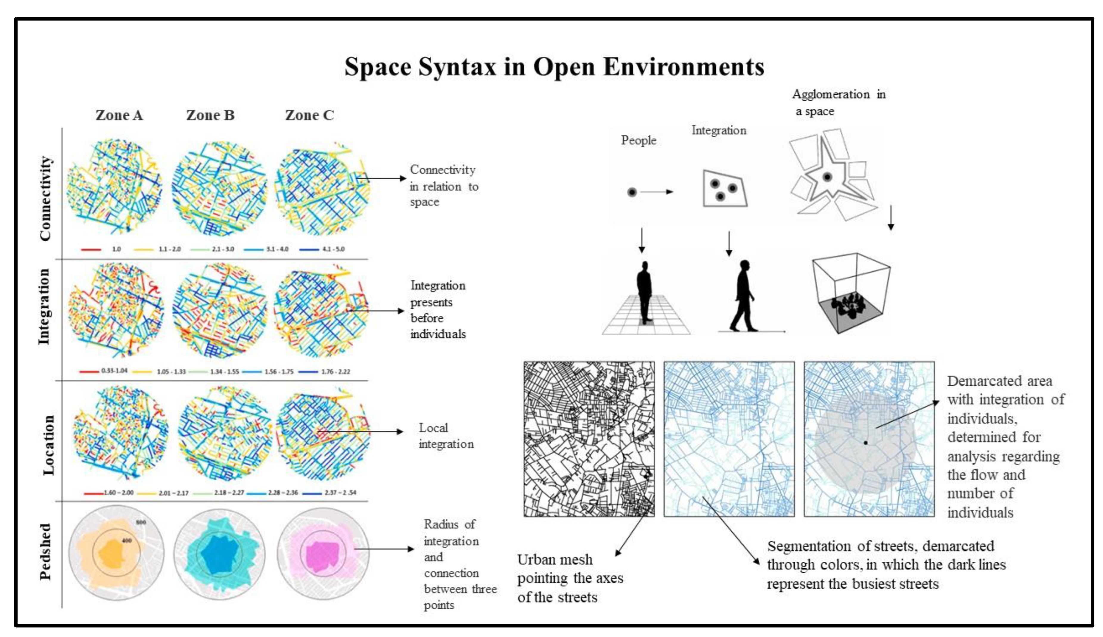
Figure 1. Representation of Space Syntax utilized in open urban spaces. Source: Adapted from Koohsari et al. [22], Tannous et al. [23], El-Darwish [24], Garau and Annunziata [25], Gha-raibeh et al. [26], Soltani et al. [27], Yildirim and Çelik [28].
Preprints 79090 g001
Figure 2. Representation of frequencies in urban environments with open pedestrian flows. Modified from the following sources: Koohsari et al. [22], Tannous et al. [23], El-Darwish [24], Garau and Annunziata [25], Gharaibeh et al. [26], Soltani et al. [27], Yildirim and Çelik [28].
Preprints 79090 g002
Figure 3. Representative conceptions space syntax in a closed flow environment. Source: Alitajer and Nojoumi [5], Askarizad and Safari [6], Tanaka et al. [7], and Zerouati [8].
Preprints 79090 g003
Figure 4. Perception of frequency in relation to the terms of space, movements, environment, flow, form, circulation and movements in relation to the Space Syntax of internal closed built spaces. Modified after the following sources: Alitajer and Nojoumi [5], Askarizad and Safari [6], Tanaka et al. [7], and Zerouati [8].
Preprints 79090 g004
Table 1. Space Syntax in open environments identified by frequency from MAC.
Authors Objective Result/Conclusion Positivity of the analysis
Koohsari et al. [22] Emphasize the importance of pedestrian movements in relation to the mobility of space due to the layout of the urban fabric. The need for studies of movements in the urban fabric, in conjunction with urban architects and geographers. Projections of pedestrian movements in the urban fabric need improvement through the creation of new software.
Tannous et al. [23] Identify the importance of pedestrian movements in the urban fabric. The analysis of the urban fabric becomes fundamental in the pursuit of accessibility. Paths taken by individuals in the urban fabric have the ability to improve the quality of life of citizens.
El-Darwish [24] Diagnose types of pedestrian movements in the urban fabric, with actions that contribute to the quality of life of users. Paths taken by individuals in residential areas need to improve the quality of life of users through alterations in urban infrastructure. The way of analyzing mobility contributes to improving overall urban infrastructure in order to seek a higher quality of life for individual users.
Garau and Annunziata [25] Analyze the pedestrian movements of people in the urban fabric. The study shows the importance of the quality of the space's layout, which increases the users' quality of life. Software can be utilized to better design pedestrian movement through the urban fabric.
Gharaibeh et al. [26] Analyze accessibility in pedestrian movements in order to demarcate transport areas in the urban fabric. Through the analysis of the urban fabric, new routes can be designed in this space, in addition to the implementation of new ways to encourage the use of public transport. The analysis of the urban fabric enhances future research in search of computational programs capable of contributing to the overall design of the urban built environment.
Soltani et al. [27] Analyze the urban fabric and the daily pedestrian movements of individuals as they move through the urban fabric. The pedestrian movements of individuals support the interaction of people in the urban fabric. Adequate mobility in the urban fabric provides improvements in the road network in order to designate the best placement of new roads and pedestrian paths.
Yıldırım and Çelik [28] Verify modeled movements of pedestrians throughout the urban fabric. Better understand how pedestrian movements are governed by the constructed urban fabric. Pedestrian movement can be influenced by the design of the urban fabric.
Source: Based on Koohsari et al. [22], Tannous et al. [23], El-Darwish [24], Garau and Annunziata [25], Gharaibeh et al. [26], Soltani et al. [27], Yildirim and Çelik [28].
Table 2. Indoor Space Syntax identified by frequency from CAM.
Authors Objective Result/Conclusion Positivity of the analysis
Alitajer and Nojoumi [5] Analyze the movements of individuals in internal spaces in traditional and modern buildings in Hamedan using Space Syntax. The influence on the design of a building is favored by the integration of the environment with the circulation of people. The use of auxiliary software at the time of the project facilitates the analysis of the form, with the understanding of the movements of the individuals in the projected environment, contributing to the improvement of the conceived space.
Askarizad and Safari [6] Understand people’s behavior and their movements inside the built space. The study of flow in built space helps urban architects in the initial phase of the project. The importance of open space, with analysis of the movement of people causes greater security for users.
Tanaka et al. [7] Check with a statistical method the disposition, the time of entry and exit, form and flows of people in the built space. Analyses with data in space subdivided into points in the environment with the greatest flow of movements optimize flow within the building. The disposition and time in relation to the flow of individuals. Such movements can be understood in relation to the number of people in the projected space.
Zerouati [8] Analyze the quality of life in a built space. The form of flow hierarchy stands out in the different points of view of the designer. The way of analyzing the flow of people varies according to the environment in relation to public or private spaces.
Source: Alitajer and Nojoumi [5], Askarizad and Safari [6], Tanaka et al. [7], and Zerouati [8].
Disclaimer/Publisher’s Note: The statements, opinions and data contained in all publications are solely those of the individual author(s) and contributor(s) and not of MDPI and/or the editor(s). MDPI and/or the editor(s) disclaim responsibility for any injury to people or property resulting from any ideas, methods, instructions or products referred to in the content.
Copyright: This open access article is published under a Creative Commons CC BY 4.0 license, which permit the free download, distribution, and reuse, provided that the author and preprint are cited in any reuse.
Alerts
Prerpints.org logo

Preprints.org is a free preprint server supported by MDPI in Basel, Switzerland.

Subscribe

© 2025 MDPI (Basel, Switzerland) unless otherwise stated