1. Introduction
Planted forests play a significant role in making substantial contributions to climate change mitigation and promoting the carbon cycle within ecosystems. The forest stock volume (FSV) is regarded as one of key indices in evaluating the quality of planted forests [
1,
2]. Normally, traditional methods of investigating FSV are obtained by time-consuming and costly ground measurements, which are hard to satisfy the requirement of modern forest resource monitoring [
3]. In the recent twenty years, remote sensing technology provides a more promising approach to indirectly mapping FSV with a few ground-measured samples for large regions [
4]. However, electromagnetic signals reflected from forests are often prevented by cloud cover using optical remote sensing images [
5,
6,
7]. Furthermore, optical remote sensing images are still useless for forests during the deciduous season. To overcome these disadvantages, Polarimetric Synthetic Aperture Radar (PolSAR) images have a great potential to map FSV by excellent penetration capabilities and distinct microwave scattering processes [
8].
Commonly, various bands (X, C, and L bands), and various polarization modes (single, dual, and quad) SAR images have been widely applied in mapping forest parameters [
9,
10,
11]. Previous results have demonstrated that polarization features extracted from quad-polarization SAR images had a remarkable sensitivity to FSV [
12]. However, the number of images acquired with dual polarization mode is much larger than that with quad polarization mode among these available SAR sensors [
9]. Therefore, dual polarization SAR images are still a main option to map forest parameters in large region, recently. Furthermore, sensitivity of features related to FSV is affected by the ability to penetrate the forest. As the wavelength increases, the ability of SAR signal to penetrate the forest increases [
13,
14]. Previous studies have indicated that L-band SAR images showed greater sensitivity to FSV than C and X-band SAR images in growing season [
15]. For evergreen and deciduous forests at non-growing season, it is valuable to further interpret the response of FSV with dual polarization SAR images with various bands, such as C and L band SAR images.
Normally, features extracted from dual polarization SAR images with different bands show different sensitivities to FSV. Recently, two polarization combinations are widely provided for dual polarization images, such as HH (horizontal transmission and horizontal reception) and HV polarization (horizontal transmission and vertical reception) for GF-3 and ALOS-2, VV (vertical transmission and vertical reception) and VH (vertical transmission and horizontal reception) for Sentinel-1[
16]. Previous results have shown that the sensitivity between the backscatter coefficient of cross-polarization (HV and VH) and FSV is significantly higher than co-polarization (HH and VV) [
17,
18,
19]. Because of the different penetration abilities, some studies also showed that C-band SAR images were more closely related to forest crowns, while L-band images received more reflection information of trunks and branches [
20,
21,
22,
23]. Although L-band SAR images have higher saturation levels for mapping forest FSV, it still affects the accuracy of estimating forest FSV, especially for mature planted forests [
24,
25,
26,
27]. Furthermore, previous results have shown that the accuracy of mapping FSV had been greatly improved by using multiple bands SAR images [
28,
29,
30]. However, it is still an uncertain question to clarify the combined effects of bands and polarization modes for different tree species and their growth conditions.
Additionally, forest types are also one of key factors that influences the sensitivity between forest FSVs and features extracted from PolSAR images [
31,
32]. Previous studies have indicated that the accuracy and saturation levels of mapping FSV have significant differences in tropical broadleaf forests and sub-boreal coniferous forests using the same bands of SAR images [
33]. Moreover, the accuracy of mapped AGB in deciduous and evergreen forests has great gaps using Sentinel-1 images in the same region [
34]. Therefore, it is valuable to analyze seasonal factors for mapping forest FSV using dual polarization SAR images in deciduous forests.
The objective is to clarify the response of forest FSV to various dual-polarization SAR images with different bands and polarization modes in deciduous (Larch) and evergreen (Chinese pine) forests and interpret the combined effects of mapping forest FSV using GF-3, Sentinel-1, and ALOS-2 dual SAR images acquired at the non-growing season. In this study, several types of alternative features were initially extracted from three types of acquired dual polarization SAR images, and the sensitivity between features and forest FSV was analyzed to clarify the response of forest FSV to bands and polarization modes. Finally, using the sequential forward selection method and four machine learning models, mapped FSVs were derived from various combined images with bands and polarization modes in evergreen and deciduous forests at non-growing season.
2. Materials and Methods
2.1. Studying area
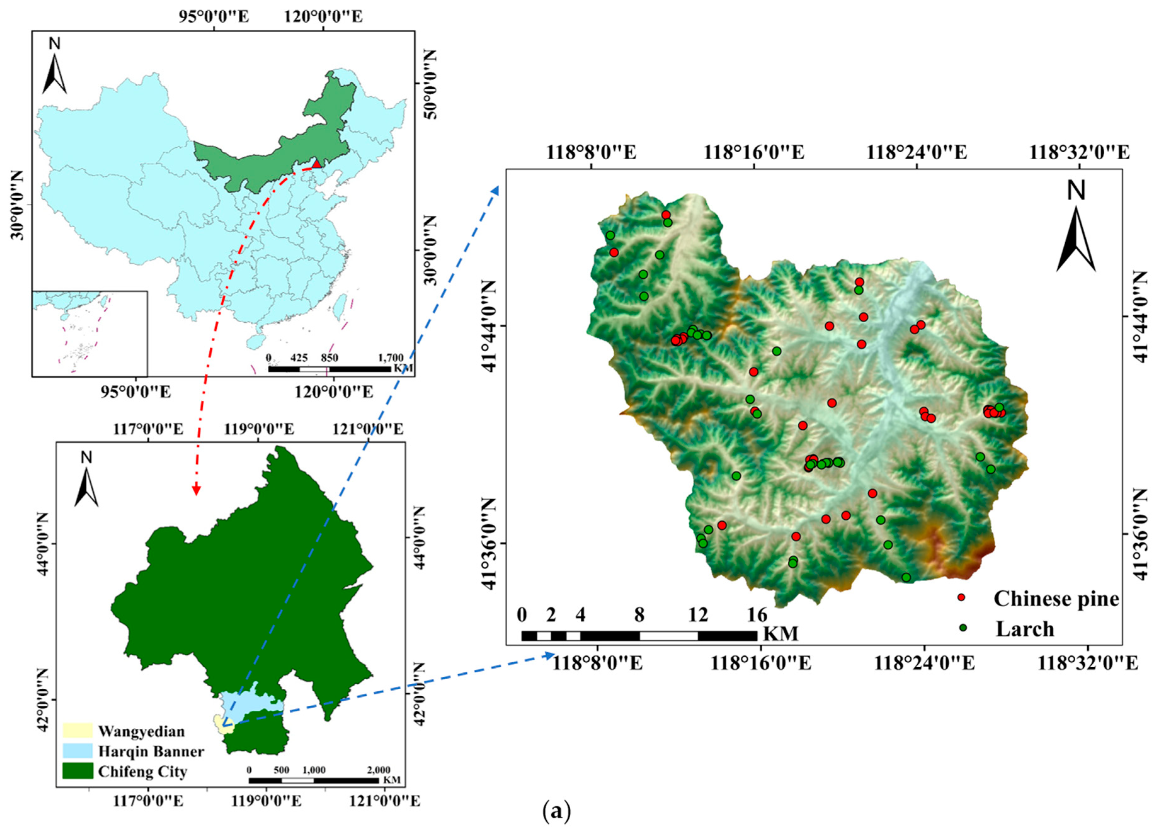
The study area was conducted in Wangyedian Experimental Forest Farm located in Harqin Banner, Inner Mongolia Autonomous Region, China (
Figure 1). The geographic coordinates of forest farm are east longitude ranged from 118°09’ to 118°30’ and north latitude ranged from 41°21’ to 41°39’, respectively. The terrain is characterized by mid-low mountainous areas, with elevations ranging from 600 m to 1890 m. According to statistics data from 2016, the area of forest cover is up to 23,300 hectares, with a forest coverage rate of 93%. The total volume of timber is near to 1.527 million m
3, and 49.78% of the research area (approximately 11,600 hectares) is covered by planted forests, mainly tree species of Larch (
Larix principles-Ruprecht and Larixolgensis) and Chinese pine (
Pinus tabuliformis).
2.2. Ground data
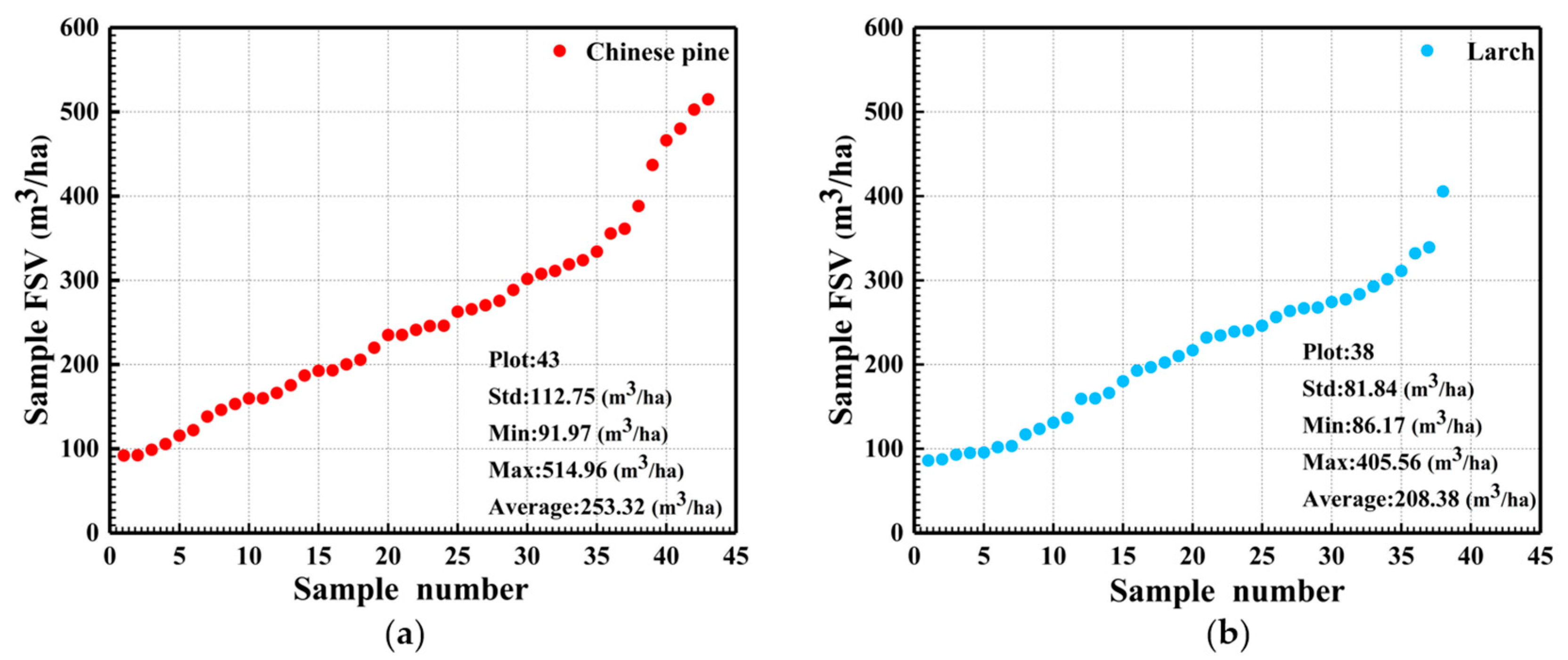
For mapping forest FSV, the field-measured data in this study was conducted in October 2017. Based on the age and tree species, a total of 81 ground samples (Larch: 38 and Chinese pine: 43) were determined by stratified random sampling method. For each sample with a size of 25 m × 25 m, the position of corners and centers were precisely surveyed by GNSS with errors of less than 10 cm. And then, tree height, DBH (diameter at breast height), and crown size of each tree in sample were measured. The volume of each tree was calculated using the bivariate volume equation based on the collected tree parameters (
Table 1). Finally, FSV is obtained by the sum of all trees in one sample. The distribution of FSV is illustrated in
Figure 2.
2.3. Dual polarization SAR images and DEM
In this study, forest FSV was estimated using three types of C and L bands dual polarimetric SAR images acquired in March 2017, including GF-3 (C band), Sentinel-1 (C band), and ALOS-2 (L band).
Table 2 listed the information of acquired multi-band dual polarizations SAR images. For GF-3 and ALOS-2 images, the polarization mode is HH and HV, and for Sentinel-1 images, the polarization mode is VV and VH. Additionally, open-sourced digital elevation model (DEM) with a spatial resolution of 30 m was also employed to geocode the SAR images.
2.4. Dual polarization SAR images pre-processing
Normally, several images pre-processing steps were employed before extracting alternative features from dual polarization SAR images. Firstly, radiation calibration was applied to convert the amplitude information into quantitative values. Secondly, the multi-look processing and adaptive Frost filtering with a window size of 5×5 were performed to smooth the coherent speckle noise of SAR image. In addition, topographic radiation correction was also needed to reduce the topographic influences, such as shrinkage, overlay and shadowing. Finally, all images were geocoded using external digital elevation model (DEM) with spatial resolution of 30 m.
2.5. Feature extraction
For dual polarization SAR images, it is rather necessary to extract enough features for mapping forest FSV, and backscattering coefficients with different polarizations are initially extracted. Commonly, these backscattering coefficients of dual-polarization SAR include two polarization combinations, HH/HV (GF-3 and ALOS-2) and VH/VV(Sentinel-1). For increasing the number of alternative features, mathematical operations between backscattering coefficients with different polarizations were applied and eighteen features were extracted from each type of SAR images in this study (
Table 3).
Furthermore, Gray Level Concurrence Matrix (GLCM) was also employed to extract textural information from each polarized intensity images (σHH, σHV, σVH, and σVV), there were eight textural features, including mean, variance, homogeneity, contrast, dissimilarity, entropy, second moment and correlation, were obtained from each image with various window sizes (ranged from 5 to 9).
2.6. Feature selection and models
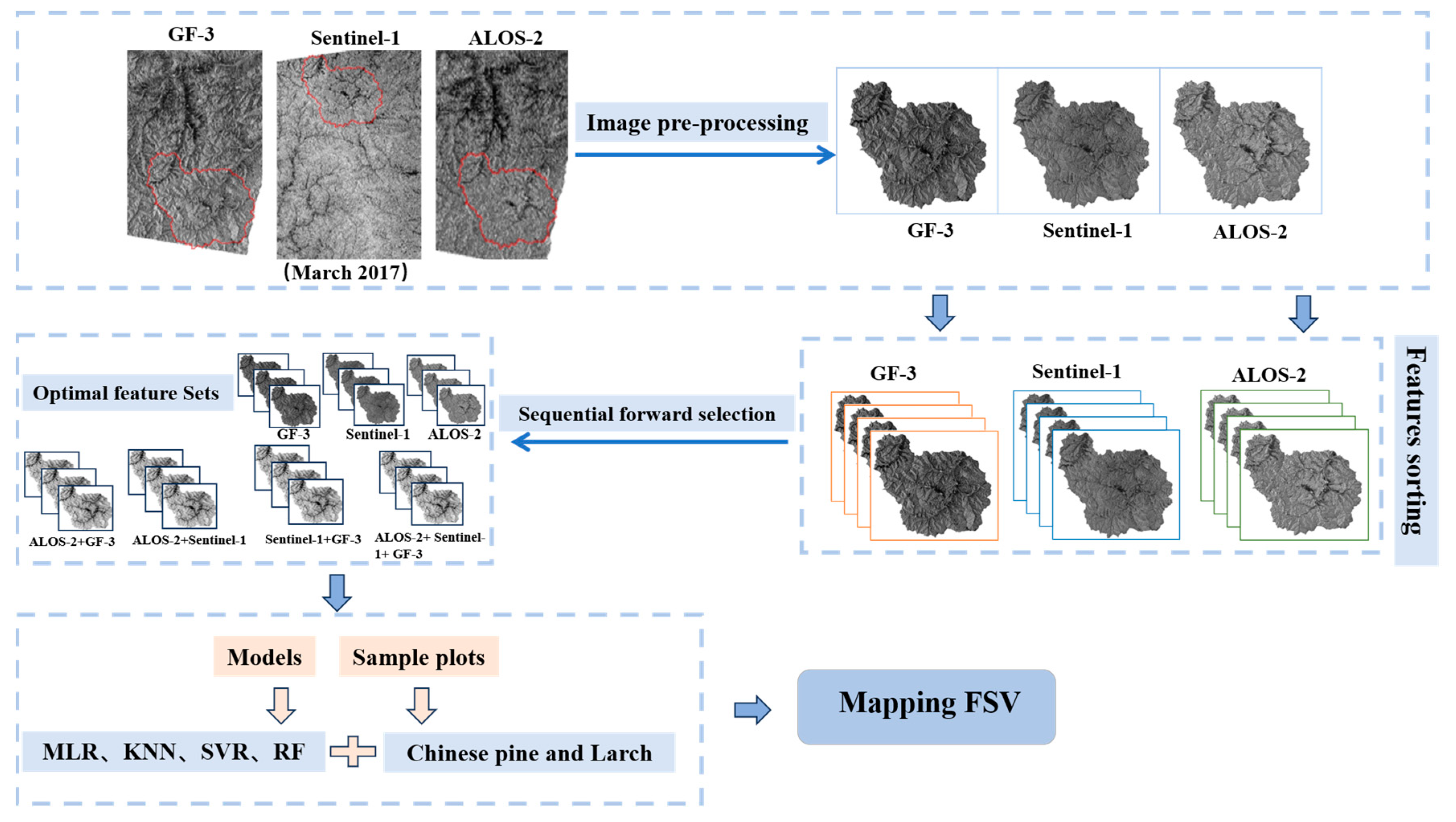
To obtain the optimal feature set, the sensitivity between features and FSV was firstly evaluated by Pearson correlation coefficient and the absolute values of the correlation were also obtained. Then, the features were ordered in descending according to the Pearson correlation coefficient. After getting sorted features, the sequential forward selection method and four machine learning models were employed to construct wrapped feature selection methods. Finally, optimal feature sets were obtaining by removing the features with poor contributions to accuracy of estimating FSV. In this study, K-Nearest Neighbors Regression (KNN), Multiple Linear Regression (MLR), Random Forest Regression (RF), and Support Vector Machine Regression (SVR) were employed to map FSV using wrapped feature selection methods. Furthermore, combined images of different strategies (ALOS-2+GF-3, ALOS-2+Sentinel-1, Sentinel-1+GF-3, and ALOS-2+ Sentinel-1+GF-3) were formed to interpret the combined effects of mapping forest FSV. Framework of mapping FSV with combined dual polarization SAR data was illustrated in
Figure 3.
2.7. Accuracy evaluation
Based on the number of samples, LOOCV was employed to evaluate the accuracy of mapping FSV among various combined SAR images. Specifically, Root Mean Square Error (RMSE), Relative Root Mean Square Error (rRMSE), and Coefficient of Determination (R-squared, R
2) are selected as the accuracy evaluation metrics for evaluating models. The formulas of these evaluation metrics are as follows.
where
indicates the predicted FSV,
is the measured FSV,
indicates the mean of the measured FSV, and
n indicates the total number of samples.
3. Results
3.1 The sensitivity between features and forest FSV
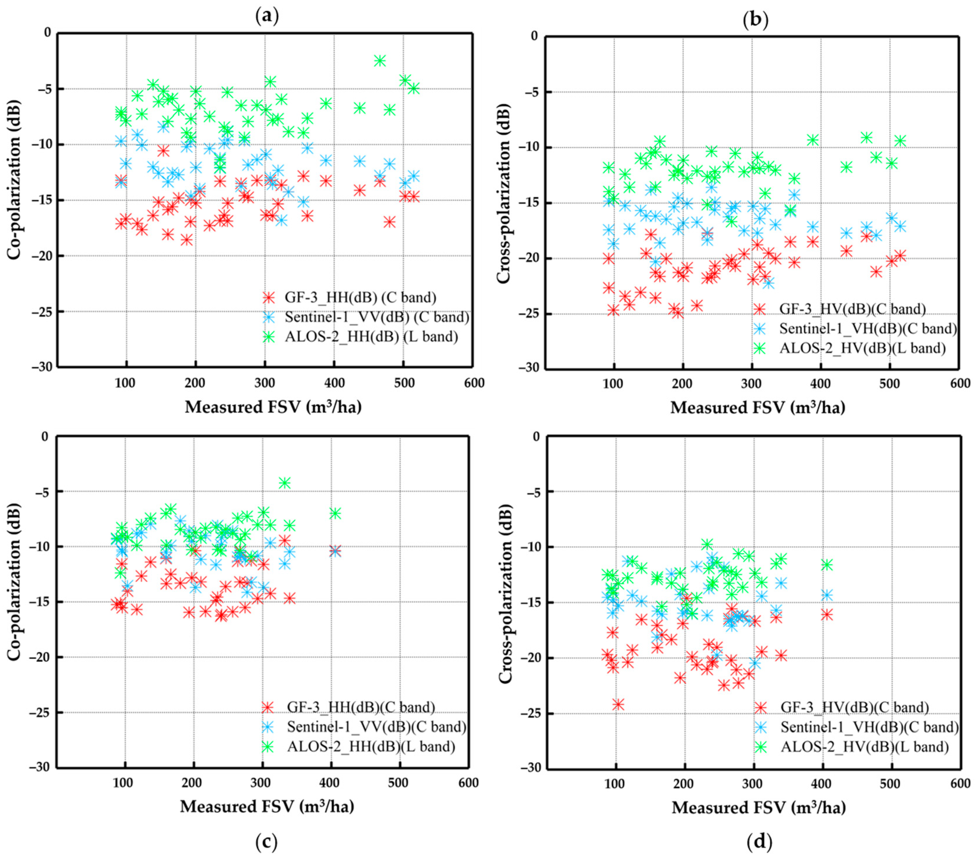
For planted Chinese pine and Larch at the non-growing season, the backscattering energy with different bands and polarization modes was extracted to explore the response of FSV (
Figure 4). The results illustrated that these scattering energy from the HH and VV polarization mode was obvious greater than that from HV and VH, because of differences in scattering mechanisms. Moreover, the difference of backscattering energy from different sensors is significant in planted Chinese pine forest (
Figure 4(a) and
Figure 4(b)), and the difference among these bands and polarization modes is gradually reduced in planted Larch forests (
Figure 4(c) and
Figure 4(d)). Specially, it was difficult to distinguish the difference of backscattering energy between ALOS-2 and Sentinel-1 in co-polarization and cross-polarization modes in planted Larch forests. For the same polarization mode, differences of penetration capacity with L and C bands can still be clearly identified in deciduous forest at non-growing season. It is implied that the difference of backscattering energy in bands and polarization modes can be recognized in evergreen and deciduous forest at non-growing season.
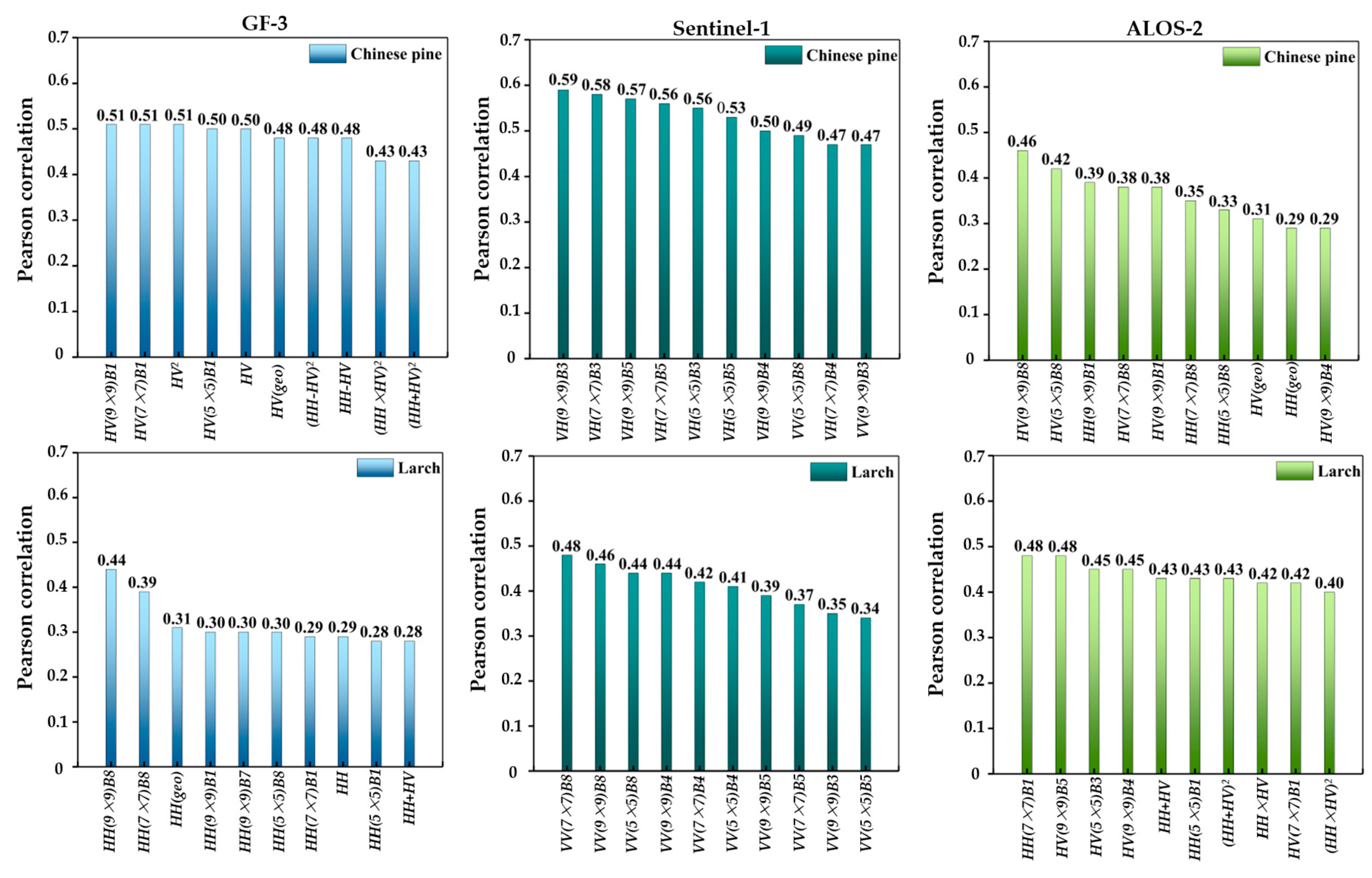
Moreover, the absolute values of Pearson correlation coefficient between FSV and all alternative features extracted from three types of sensors were used to further explore the sensitivity. The top ten sensitivity features of planted Chinese pine and Larch in different sensors were illustrated in
Figure 5, respectively. For planted Chinese pine, the absolute values of Pearson correlation coefficient were ranged from 0.43 to 0.51 for GF-3, and from 0.47 to 0.59 for Sentinel-1, and from 0.29 to 0.46 for ALOS-2, respectively (
Figure 5). It is found that the texture features from three types of dual polarization SAR images correlated well with the FSV, and the absolute values of Pearson correlation between FSV and texture features extracted from cross-polarization images had higher sensitivity than these extracted from co-polarization images (
Figure 5). For planted Larch at non-growing season, the texture features from three types of dual polarization SAR images also correlated well with the FSV (
Figure 5), and the absolute values of Pearson correlation between FSV and texture features extracted from ALOS-2 were obvious higher than that these extracted from GF-3 and Sentinel-1 (
Figure 5). It is demonstrated that features extracted from three types of dual polarization SAR images have great potential to map FSV in evergreen and deciduous forest at non-growing season.
3.2. The results of estimated FSV using single dual-polarization SAR images
To further evaluate the potential of these dual polarization SAR data in mapping FSV at non-growing season, the sequential forward selection and four machine learning models (MLR, KNN, SVR, and RF) was employed to construct wrapped feature selection methods, and the optimal feature sets were ultimately obtained for each type of dual polarization SAR images. The results of estimated FSV of Chinese pine and Larch are shown in
Table 6. Among the three types of dual-polarization SAR data, the differences of rRMSE in different models were less than 5 percentage points.
For Chinese pine, the values of rRMSE using optimal feature sets ranged from 30.58% to 34.08% for GF-3, and from 31.60% to 37.99% for Sentinel-1, and from 29.33% to 33.07% for ALSO-2, respectively (
Table 6). The highest average accuracy of mapping FSV obtained using dual polarization ALSO-2 images. The results indicated that the L-band dual polarization images (ALSO-2) have more potential than C-band images (GF-3 and Sentinel-1) in mapping forest FSV in evergreen forest. For planted Larch, the values of rRMSE using optimal feature sets ranged from 27.34% to 32.80% for GF-3, and from 24.47% to 28.49% for Sentinel-1, and from 30.05% to 33.13% for ALSO-2, respectively (
Table 6). The highest average accuracy of mapping FSV obtained using dual polarization Sentinel-1 images. The results also showed that the accuracy of mapping FSV using C-band dual polarization SAR images (GF-3 and Sentinel-1) were slightly higher than that using L-band dual polarization SAR images (ALSO-2). It is demonstrated that polarization mode is more important than penetration capability of bands in mapping forest FSV in deciduous forest at non-growing season.
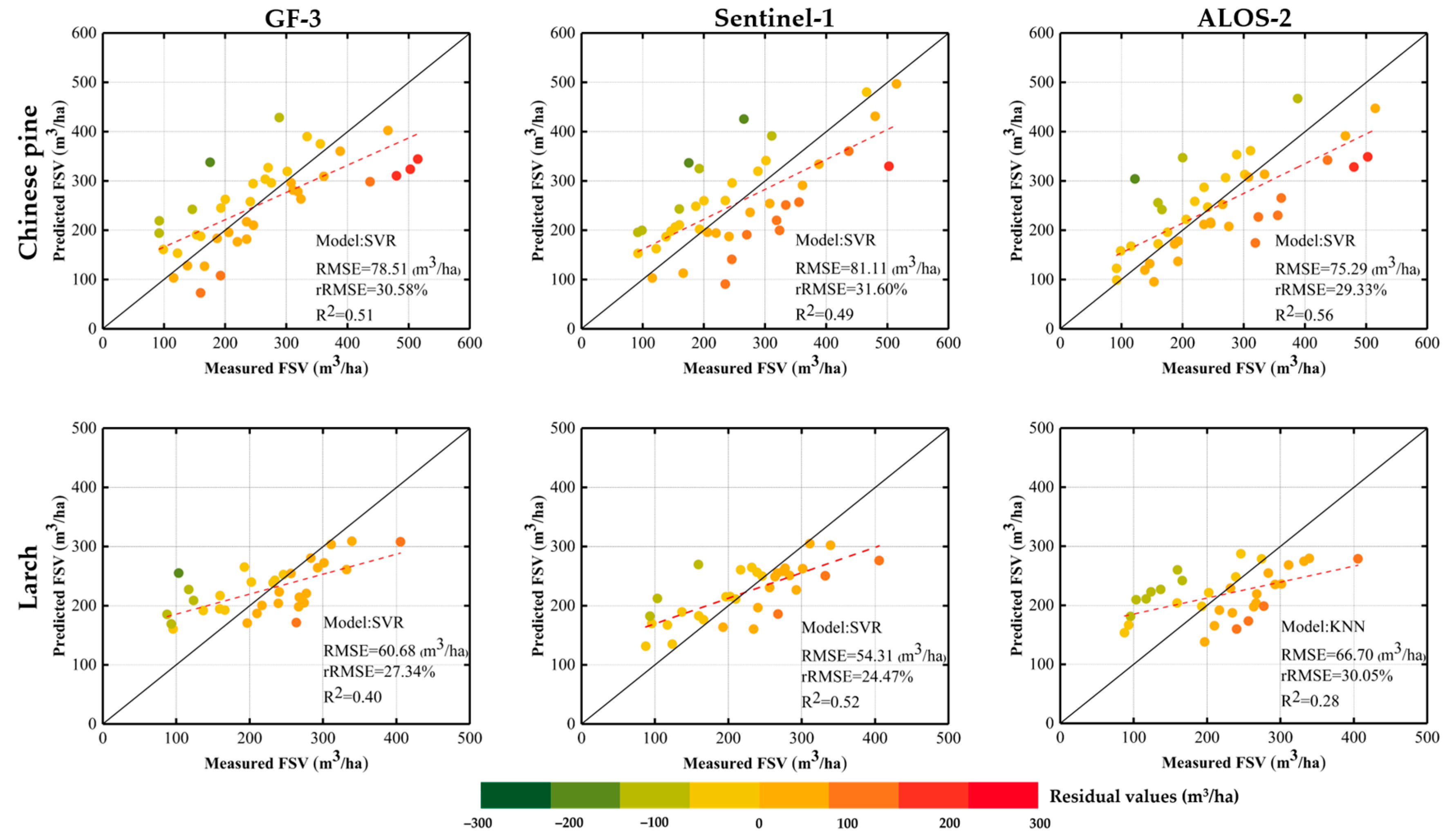
To further validate capability of three SAR data in mapping FSV, the scatter plots and residuals between predicted and measured FSV of samples were demonstrated using the models with the highest accuracy of results from each type of data (
Figure 6). The results demonstrated that the accuracy of mapping FSV in Chinese Pine forests was higher than that in Larch forests at non-growing season. Furthermore, the number of under-estimation samples in Larch forests was obvious larger than that in Chinese Pine forests. To improve the accuracy of mapping FSV, it is valuable to further analyze the response of FSV with combined strategy with bands and polarization modes.
3.3. The results of estimated FSV using combined images of different strategies
To further analyze the potential of combined dual polarization SAR data with different bands and polarization modes, the combined images of different strategies were used to map the FSV in Chinese pine and Larch forests at non-growing season, respectively. The optimal feature sets of combined images were also obtained by the forward feature selection method and four machine learning models (MLR, KNN, SVR, and RF). The accuracy indices of mapping FSV using combined images of different strategies were listed in
Table 7.
Using combined images of different strategies, the accuracy of mapped FSV was obvious improved in Chinese pine and Larch forests. The values of R
2 ranged from 0.42 to 0.77 for Chinese pine forest and from 0.23 to 0.53 for Larch forests, respectively (
Table 7). Moreover, the values of average rRMSE obtained from combined dual polarization images (ranged from 25.60% to 29.56%) were significant smaller than that from single dual polarization images (ranged from 31.21% to 35.23%) in Chinese pine forests (
Table 7), and the best results were obtained from combination with three types of sensors (ALOS-2+ Sentinel-1+ GF-3). For Larch forests, the values of average rRMSE obtained from combined dual polarization images (ranged from 26.18% to 27.68%) were slightly smaller than that from single dual polarization images (ranged from 26.63% to 31.06%) (
Table 7), and the best results were also obtained from combination with three types of sensors (ALOS-2+ Sentinel-1+ GF-3). The results demonstrated that combined images with bands and polarization modes have capability to improve the accuracy and reliability of mapped FSV, and the degree of accuracy improvement is related to tree species and season.
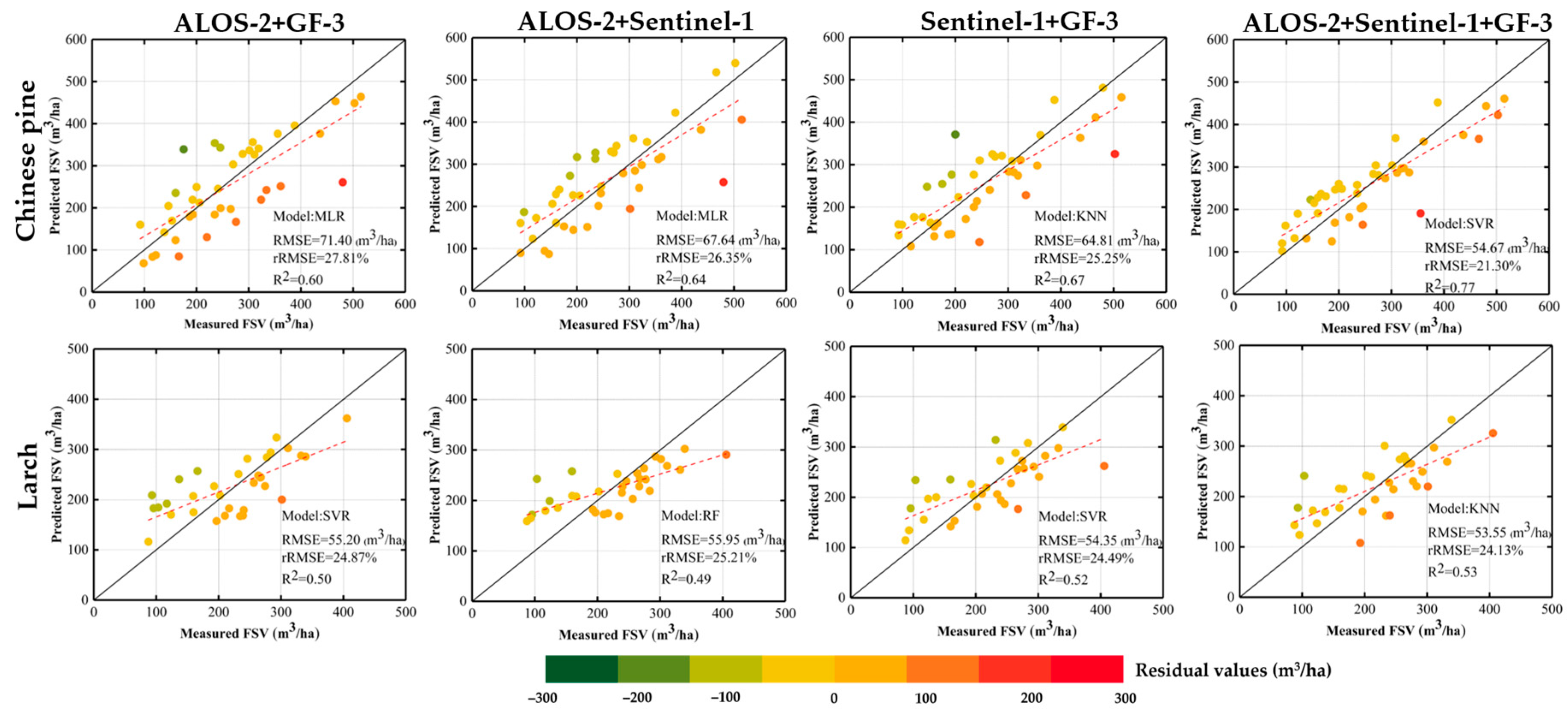
To further interpret the response of FSV with different types of dual polarization SAR images, scatter plots and residuals between predicted and measured FSV were plotted using the best results of each type of combination (
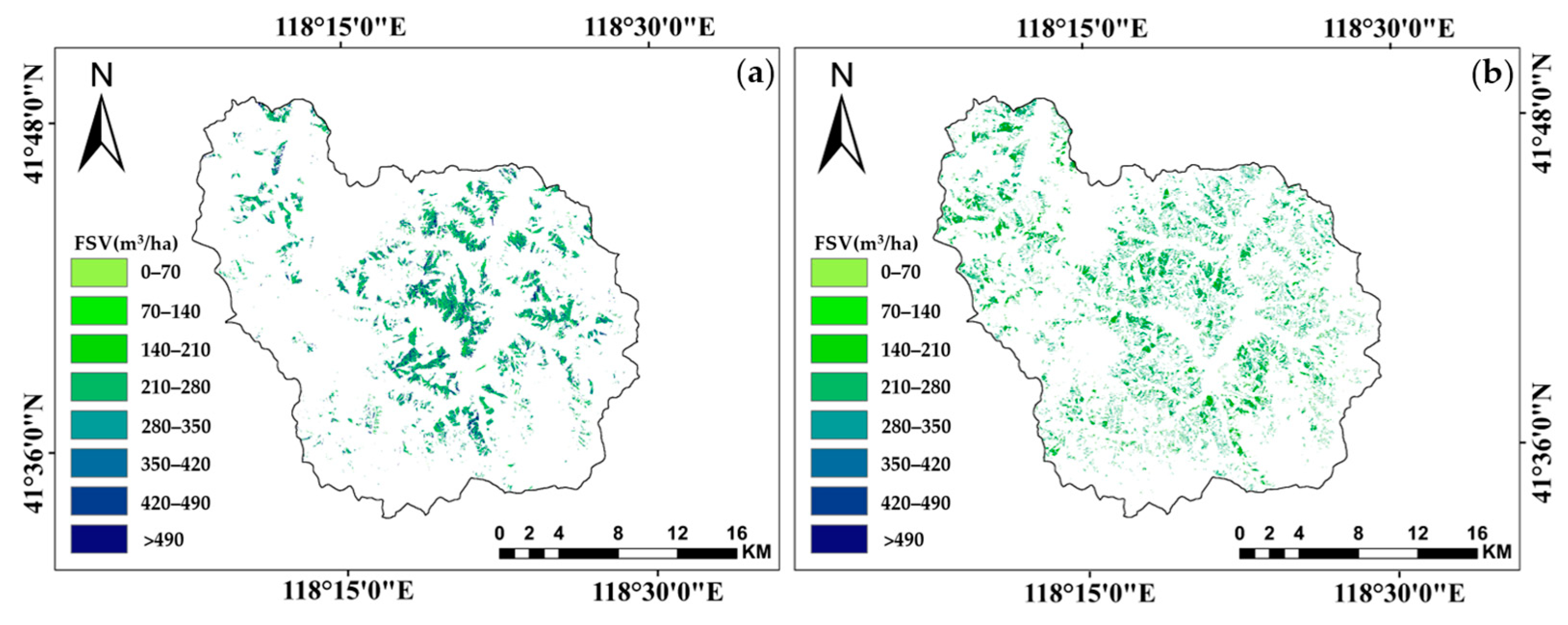
Figure 7). The results demonstrated that combined dual polarization images with different strategies can improve accuracy due to a significant improvement in under-estimation. It is inferred that compensation effect with bands and polarization modes have exciting potential to delay the saturation phenomenon. Additionally, the results also demonstrated that over-estimated results occurred in low FSV were also obviously improved using combined dual polarization SAR images with different strategies, and the degree of improvement in planted Chinese pine were higher than that in planted Larch. In this study, the maps of forest FSV were finally generated by the best models using combined three types of dual polarization SAR images (ALOS-2+Sentinel-1+GF-3) in evergreen (
Figure 8(a)) and deciduous forest (
Figure 8(b)) at non-growing season, respectively.
4. Discussion
4.1. Polarization response of deciduous and evergreen coniferous forests
Previous studies showed that the sensitivity between FSVs and alternative features closely relates to bands and polarization modes [
35,
36]. For deciduous and evergreen coniferous forests, the difference of backscattering energy in HH polarization is mainly caused by the penetration capability related to bands. Therefore, information of trunks and branches acquired by L band SAR images are more than that acquired by C band SAR images [
38]. Furthermore, backscattering energy in HV polarization reflected from canopy of forest is commonly lower than that in HH polarization in the same type of sensors [
39]. In this study, the difference of backscattering energy in co-polarization modes highly related to bands and tree species at non-growing season (
Figure 4). The obvious gaps of backscattering energy in co-polarization modes can be observed between GF-3 and ALOS-2 in evergreen forest (Chinese pine), and the gaps were reduced in deciduous forest (Larch) at non-growing season (
Figure 4). Moreover, features extracted from Sentinel-1 with VV polarization have more potential than that extracted from ALOS-2 and GF-3 images in mapping FSV in deciduous forest at non-growing season (
Figure 5). It is inferred that polarization modes are the key factor in mapping FSV in deciduous forest without leaves [
40,
41].
In addition, the sensitivity between features and FSVs is influenced not only by bands and polarization modes, but also by forest structure [
42,
43,
44,
45,
46,
47]. Previous studies have been shown that polarization features are highly correlated with forest parameters in evergreen forest [
48]. Normally, backscattering energy extracted from dual SAR images with C-band mainly reflects forest canopy information, and the images with L-band reflects trunk information below the canopy [
49,
50]. In non-growing season, the main difference between evergreen and deciduous forests is the depth of crowns. For deciduous forests without leaves, the effect of microwave signal penetration on the scattering energy becomes weak, and the polarization modes become the main factor affecting the scattering signal. In this study, the values of correlation between polarization features and FSV in evergreen coniferous forests (Chinese pine) were higher than that in deciduous coniferous forests (Larch) in the non-growing season. Specially, the polarization features extracted from Sentinel-1 images were highly correlated with FSV of evergreen coniferous forests (Chinese pine), but the estimated accuracy of mapped FSV using single Sentinel-1 images was the lowest among three types of sensors. For deciduous forests without leaves, the correlations between features extracted from ALOS-2 and FSV were slightly higher than that extracted from Sentinel-1, but the accuracy of mapped FSV using Sentinel-1 images was higher than that using ALOS-2 images in deciduous coniferous forests (Larch). At non-growing season, the results implied that the accuracy of mapping FSV in evergreen coniferous forests (Chinese pine) depends on bands [
28,
51], while mapping FSV in deciduous coniferous forests (Larch) mainly depends on polarization modes at non-growing season [
28].
4.2. Combined effects of multi-bands dual-polarization SAR images
Because of different penetration capabilities and distinct microwave scattering processes in evergreen and deciduous coniferous forests, the accuracy of mapping FSV were commonly depended on the bands and polarization modes [
52,
53,
54,
55,
56]. Previous studies have shown that the accuracy of estimating FSV using the L-band dual polarization SAR images is higher than that using C-band images, caused by penetration capabilities to improve the under-estimation results and delay the saturation levels [
57,
58]. In this study, using single-band polarization SAR images, the best accuracy of FSV estimation in evergreen coniferous forests (Chinese pine (R
2): ranged from 0.49 to 0.56) was significantly higher than that in deciduous coniferous forests (Larch (R
2) ranged from 0.28 to 0.52). The number of samples with under-estimated FSV in deciduous forests (Larch) was larger than that in evergreen coniferous forests (Chinese pine) (
Figure 6). It is confirmed that the L- band dual polarization SAR images is more suitable for mapping FSV in evergreen forest (Chinese pine), and Sentinel-1 images with VV and VH polarization may be more suitable for mapping FSV in deciduous coniferous forests (Larch) at non-growing season.
Previous studies have also shown that combined images with different bands and polarization modes can improve the accuracy of mapping FSV [
59,
60]. The degree of accuracy improvement is severely related to the combination strategies and forest structure parameters. In this study, the results demonstrated that the accuracy of mapping FSV using combined SAR images was significant improved compared to the results derived from single type of sensor (
Figure 9). The main reason for the improvement of accuracy is that overestimation and underestimation have been greatly alleviated using combined SAR images. It is confirmed that combined effects of multi-bands dual-polarization SAR images have great potential for delay saturation levels.
In addition, the accuracy of mapping FSV using combined images related to combination strategies. In this study, the results also demonstrated that there is little variation in accuracy between different combinations using various combined images with two types of sensors, the best results were obtained from combination with three types of sensors (ALOS-2+ Sentinel-1+ GF-3). It is implied that dual polarization SAR images with various bands and various polarization modes contain different scattering information for evergreen and deciduous coniferous forests, and these complementary makes an important contribution to improve the accuracy of mapping FSV [
61,
62].
5. Conclusions
Mapping forest FSV using dual polarization SAR images is rarely conducted at non- growing season. In this study, three dual polarization SAR images (GF-3, Sentinel-1, and ALOS-2) were acquired in March 2017 in planted Larch and Chinese pine forests. Then, backscattering energy of co-polarization and cross-polarization and sensitivity between FSV and all alternative features were analyzed to express the difference of bands and polarization modes in deciduous and evergreen forest at non-growing season. The results demonstrated that the difference of backscattering energy in bands and polarization modes can be recognized in evergreen and deciduous forest at non-growing season. Furthermore, it is also implied that polarization mode is more important than penetration capability in mapping forest FSV in deciduous forest at non-growing season. Comparing with single dual polarization images, the accuracy of mapped FSV was obvious improved in Chinese pine (ranged from 25.60% to 29.56%) and Larch (ranged from 26.18% to 27.68%) forests using combined images with different strategies. Specially, the best results were obtained from combination with three types of sensors (ALOS-2+ Sentinel-1+ GF-3). Additionally, it is also confirmed that compensation effect with bands and polarization modes not only have great potential to delay the saturation phenomenon, but also have capability to reduce errors caused by over-estimation. To further confirm the response of forest FSV varied with season, more dual polarization SAR images and more diverse types of forest will be employed to conduct for clarifying the response changes during growing season.
Author Contributions
Conceptualization, H.Z. and J. L.; methodology, H.Z. and J.L.; software, P.Y., Z.L. and T.Z.; validation, H.Z., Z.L.; formal analysis, H.Z.; investigation, H.Z, Z.L., T.Z., P.Y. and T.Z.; resources, J.L. and H.L.; data curation, H.Z.; writing—original draft preparation, H.Z.; writing—review and editing, H.Z. and J.L.; visualization, H.Z.; supervision, J.L., Z.Z. and H.L.; project administration, H.L. and J.L.; funding acquisition, H.L. and J.L.; All authors have read and agreed to the published version of the manuscript.
Funding
This research was supported by the National Natural Science Foundation of China (Project number: 32171784); the National Natural Science Foundation of China (Project number: 42030112) and the Excellent Youth Project of the Scientific Research Foundation of the Hunan Provincial Department of Education (Project number: 21B0246).
Data Availability Statement
The observed FSV data from the sample plots and the spatial distribution data of forest resources presented in this study are available on request from the corresponding author. Those data are not publicly available due to privacy and confidentiality reasons. The GF-3 images are available from China Centre for Resources Satellite Data and Application website at
http://www.cresda.com/CN/ (accessed on 18 March 2017); The Sentinel-1 images are available from the European Space Agency (
https://www. esa.int/, accessed on 04 March 2017); Japan Aerospace Exploration Agency for the acquired ALOS-2 PALSAR-2 images (accessed on 09 March 2017) in this study.
References
- Ye, Z.; Long, J.; Zheng, H.; Liu, Z.; Zhang, T.; Wang, Q. Mapping Growing Stem Volume Using Dual-Polarization GaoFen-3 SAR Images in Evergreen Coniferous Forests. Remote Sensing 2023, 15. [Google Scholar] [CrossRef]
- Tang, C.; Ye, Z.; Long, J.; Liu, Z.; Zhang, T.; Xu, X.; Lin, H. Mapping forest and site quality of planted Chinese fir forest using sentinel images. Frontiers in Plant Science 2022, 13, 1–13. [Google Scholar] [CrossRef] [PubMed]
- Timothy, D.; Onisimo, M.; Cletah, S.; Adelabu, S.; Tsitsi, B. Remote sensing of aboveground forest biomass: A review. Tropical Ecology 2016, 57, 125–132. [Google Scholar]
- Li, X.; Lin, H.; Long, J.; Xu, X. Mapping the growing stem volume of the coniferous plantations in north China using multispectral data from integrated gf-2 and sentinel-2 images and an optimized feature variable selection method. Remote Sensing 2021, 13, 2740. [Google Scholar] [CrossRef]
- Patenaude, G.; Milne, R.; Dawson, T.P. Synthesis of remote sensing approaches for forest carbon estimation: reporting to the Kyoto Protocol. Environmental Science & Policy, 2005, 8, 161–178. [Google Scholar] [CrossRef]
- Nuthammachot, N.; Askar, A.; Stratoulias, D.; Wicaksono, P. Combined use of Sentinel-1 and Sentinel-2 data for improving above-ground biomass estimation. Geocarto International 2022, 37, 366–376. [Google Scholar] [CrossRef]
- Jiang, F. , Kutia, M., Sarkissian, A. J., Lin, H., Long, J., Sun, H., & Wang, G. (2020). Estimating the growing stem volume of coniferous plantations based on random forest using an optimized variable selection method. Sensors 2020, 20, 7248. [Google Scholar] [CrossRef]
- Shao, Z.; Zhang, L. Estimating forest aboveground biomass by combining optical and SAR data: A case study in genhe, inner Mongolia, China. Sensors 2016, 16, 834. [Google Scholar] [CrossRef] [PubMed]
- Huang, X.; Ziniti, B.; Torbick, N.; Ducey, M.J. Assessment of forest above ground biomass estimation using multi-temporal C-band Sentinel-1 and Polarimetric L-band PALSAR-2 data. Remote Sensing 2018, 10, 1424. [Google Scholar] [CrossRef]
- Zeng, P.; Zhang, W.; Li, Y.; Shi, J.; Wang, Z. Forest Total and Component Above-Ground Biomass (AGB) Estimation through C-and L-band Polarimetric SAR Data. Forests 2022, 13, 442. [Google Scholar] [CrossRef]
- Wang, M.; Zhang, W.; Ji, Y.; Marino, A.; Xu, K.; Zhao, L.; Shi, J.; Zhao, H. Aboveground Biomass Retrieval in Tropical and Boreal Forests Using L-Band Airborne Polarimetric Observations. Forests 2023, 14, 887. [Google Scholar] [CrossRef]
- Shi, J.; Zhang, W.; Marino, A.; Zeng, P.; Ji, Y.; Zhao, H.; Huang, G.; Wang, M. Forest total and component biomass retrieval via GA-SVR algorithm and quad-polarimetric SAR data. International Journal of Applied Earth Observation and Geoinformation 2023, 118, 103275. [Google Scholar] [CrossRef]
- Kumar, S. , Garg, R. D., Govil, H., & Kushwaha, S. P. S. PolSAR-decomposition-based extended water cloud modeling for forest aboveground biomass estimation. Remote Sensing 2019, 11, 2287. [Google Scholar] [CrossRef]
- Long, J.; Lin, H.; Wang, G.; Sun, H.; Yan, E. Mapping growing stem volume of Chinese fir plantation using a saturation-based multivariate method and quad-polarimetric SAR images. Remote Sensing 2019, 11, 1872. [Google Scholar] [CrossRef]
- Santoro, M.; Cartus, O. Research pathways of forest above-ground biomass estimation based on SAR backscatter and interferometric SAR observations. Remote Sensing 2018, 10, 1872. [Google Scholar] [CrossRef]
- Kasischke, E.S.; Melack, J.M.; Dobson, M.C. The use of imaging radars for ecological applications—A review. Remote sensing of environment 1997, 59, 141–156. [Google Scholar] [CrossRef]
- Robinson C, Saatchi S, Neumann M, et al. Impacts of spatial variability on aboveground biomass estimation from L-band radar in a temperate forest. Remote Sensing 2013, 5, 1001–1023. [Google Scholar] [CrossRef]
- Ranson, K.J.; Sun, G. Mapping biomass of a northern forest using multifrequency SAR data. IEEE Transactions on Geoscience and Remote Sensing 1994, 32, 388–396. [Google Scholar] [CrossRef]
- Santoro M, Beer C, Cartus O, et al. Retrieval of growing stock volume in boreal forest using hyper-temporal series of Envisat ASAR ScanSAR backscatter measurements. Remote Sensing of Environment 2011, 115, 490–507. [Google Scholar] [CrossRef]
- Le Toan, T.; Beaudoin, A.; Riom, J.; Guyon, D. Relating Forest Biomass to SAR Data. IEEE Transactions on Geoscience and Remote Sensing 1992, 30, 403–411. [Google Scholar] [CrossRef]
- van Zyl, J. J. Unsupervised classification of scattering behavior using radar polarimetry data. IEEE Transactions on Geoscience and Remote Sensing 1989, 27, 36–45. [Google Scholar] [CrossRef]
- Chowdhury, T.A.; Thiel, C.; Schmullius, C.; Stelmaszczuk-Górska, M. Polarimetric parameters for growing stock volume estimation using ALOS PALSAR L-Band data over siberian forests. Remote Sensing 2013, 5, 5725–5756. [Google Scholar] [CrossRef]
- Pulliainen, J. T. , Kurvonen, L., & Hallikainen, M. T. Multitemporal behavior of L- and C-band SAR observations of boreal forests. IEEE Transactions on Geoscience and Remote Sensing 1999, 37, 927–937. [Google Scholar] [CrossRef]
- Askne, J. I. H. , Fransson, J. E. S., Santoro, M., Soja, M. J., & Ulander, L. M. H. Model-based biomass estimation of a hemi-boreal forest from multitemporal tanDEM-X acquisitions. Remote Sensing 2013, 5, 5574–5597. [Google Scholar] [CrossRef]
- Sai Bharadwaj, P.; Kumar, S.; Kushwaha SP, S.; Bijker, W. Polarimetric scattering model for estimation of above ground biomass of multilayer vegetation using ALOS-PALSAR quad-pol data. Physics and Chemistry of the Earth 2015, 83–84, 187–195. [Google Scholar] [CrossRef]
- Ningthoujam, R. K., Joshi, P. K., & Roy, P. S. Retrieval of forest biomass for tropical deciduous mixed forest using ALOS PALSAR mosaic imagery and field plot data. International Journal of Applied Earth Observation and Geoinformation 2018, 69, 206–216. [CrossRef]
- Gao, T. , Zhu, J. J., Yan, Q. L., Deng, S. Q., Zheng, X., Zhang, J. X., & Shang, G. D. Mapping growing stock volume and biomass carbon storage of Larch plantations in Northeast China with L-band ALOS PALSAR backscatter mosaics. International Journal of Remote Sensing 2018, 39, 7978–7997. [Google Scholar] [CrossRef]
- Laurin G V, Balling J, Corona P, et al. Above-ground biomass prediction by Sentinel-1 multitemporal data in central Italy with integration of ALOS-2 and Sentinel-2 data. Journal of Applied Remote Sensing, 2018, 12, 016008. [CrossRef]
- Santi E, Paloscia S, Pettinato S, et al. The potential of multifrequency SAR images for estimating forest biomass in Mediterranean areas. Remote Sensing of Environment 2017, 200, 63–73. [Google Scholar] [CrossRef]
- Cartus, O.; Santoro, M.; Wegmüller, U.; et al. et al Estimating total aboveground stem branch biomass using multi-frequency, S.A.R. In Proceedings of the 2017 9th International Workshop on the Analysis of Multitemporal Remote Sensing Images (MultiTemp). IEEE. 2017; 1–3. [Google Scholar] [CrossRef]
- Dobson M C, Ulaby F T, Pierce L E, et al. Estimation of forest biophysical characteristics in Northern Michigan with SIR-C/X-SAR. IEEE Transactions on Geoscience and Remote Sensing 1995, 33, 877–895. [Google Scholar] [CrossRef]
- Ranson, K.J.; Sun, G. Effects of environmental conditions on boreal forest classification and biomass estimates with SAR. IEEE Transactions on Geoscience and Remote Sensing 2000, 38, 1242–1252. [Google Scholar] [CrossRef]
- Ranson, K.J.; Sun, G. An evaluation of AIRSAR and SIR-C/X-SAR images for mapping northern forest attributes in Maine, USA. Remote Sensing of Environment 1997, 59, 203–222. [Google Scholar] [CrossRef]
- Guccione, P.; Lombardi, A.; Giordano, R. Assessment of seasonal variations of radar backscattering coefficient using Sentinel-1 data. In Proceedings of the 2016 IEEE International Geoscience and Remote Sensing Symposium (IGARSS). IEEE; 2016; pp. 3402–3405. [Google Scholar] [CrossRef]
- Patel P, Srivastava H S, Panigrahy S, et al. Comparative evaluation of the sensitivity of multi-polarized multi-frequency SAR backscatter to plant density. International Journal of Remote Sensing 2006, 27, 293–305. [Google Scholar] [CrossRef]
- Tanase M A, Santoro M, De La Riva J, et al. Sensitivity of X-, C-, and L-band SAR backscatter to burn severity in Mediterranean pine forests. IEEE Transactions on Geoscience and Remote Sensing 2010, 48, 3663–3675. [Google Scholar] [CrossRef]
- Nizalapur, V.; Jha, C.S.; Madugundu, R. Estimation of above ground biomass in Indian tropical forested area using multi-frequency DLR-ESAR data. International Journal of Geomatics and Geosciences 2010, 1, 167. [Google Scholar]
- Rahman, M.M.; Sumantyo, J.T.S. Mapping tropical forest cover and deforestation using synthetic aperture radar (SAR) images. Applied Geomatics 2010, 2, 113–121. [Google Scholar] [CrossRef]
- Imhoff, M.L. Radar backscatter and biomass saturation: Ramifications for global biomass inventory. IEEE Transactions on Geoscience and Remote Sensing 1995, 33, 511–518. [Google Scholar] [CrossRef]
- Roy S, Mudi S, Das P, et al. Estimating Above Ground Biomass (AGB) and Tree Density using Sentinel-1 Data. Spatial Modeling in Forest Resources Management: Rural Livelihood and Sustainable Development, 2021: 259-280.
- Jay Labadisos Argamosa, R. , Conferido Blanco, A. , Balidoy Baloloy, A., Gumbao Candido, C., Bart Lovern Caboboy Dumalag, J., Lee Carandang DImapilis, Lady, & Camero Paringit, E. MODELLING above GROUND BIOMASS of MANGROVE FOREST USING SENTINEL-1 IMAGERY. ISPRS Annals of the Photogrammetry, Remote Sensing and Spatial Information Sciences 2018, 4, 13–20. [Google Scholar] [CrossRef]
- Mitchard ET, A.; Saatchi, S.S.; Woodhouse, I.H.; Nangendo, G.; Ribeiro, N.S.; Williams, M.; Ryan, C.M.; Lewis, S.L.; Feldpausch, T.R.; Meir, P. Using satellite radar backscatter to predict above-ground woody biomass: A consistent relationship across four different African landscapes. Geophysical Research Letters 2009, 36, 1–6. [Google Scholar] [CrossRef]
- Qazi, W.A.; Gilani, H. Exploring the use of spaceborne SAR for above ground biomass measurements in the Hindu Kush Himalayan region and Pakistan. Multi-scale for biomass assesses monit Hindu Kush Himal Reg a geospatial perspect, 2015: 102.
- Saatchi, S.; M Moghaddam. Estimation of crown and stem water content and biomass of boreal forest using polarimetric SAR imagery, IEEE Trans. Geosci. Remote Sens. 2000, 38, 697–709. [Google Scholar] [CrossRef]
- Santos, J.R.; MS, P. Lacruz, L. S. Araujo, and M. Keil. Savanna and tropical rainforest biomass estimation and spatialization using JERS-1 data, Int. J. Remote Sens. 2002, 23, 1217–122. [Google Scholar] [CrossRef]
- Mitchard ET, A.; SS Saatchi, I. H. Woodhouse, T. R. Feldpausch, S. L. Lewis, B. Sonke, C. Rowland, and P. Meir. Measuring biomass changes due to woody encroachment and deforestation/degradation in a forest-savanna boundary region of central Africa using multi-temporal L-band radar backscatter, Remote Sens. Environ. 2009, in press. [CrossRef]
- Lucas, R.M.; AK Milne, N. Cronin, C. Witte, and R. Denham. The potential of synthetic aperture radar (SAR) for quantifying the bio-mass of Australia’s woodlands, Rangeland J. 2000, 22, 124–14. [Google Scholar] [CrossRef]
- Tian L, Wu X, Tao Y, et al. Review of Remote Sensing-Based Methods for Forest Aboveground Biomass Estimation: Progress, Challenges, and Prospects. Forests 2023, 14, 1086. [Google Scholar] [CrossRef]
- Mitchell A L, Tapley I, Milne A K, et al. C-and L-band SAR interoperability: Filling the gaps in continuous forest cover mapping in Tasmania. Remote sensing of environment 2014, 155, 58–68. [Google Scholar] [CrossRef]
- Balzter, H.; Rowland, C.S.; Saich, P. Forest canopy height and carbon estimation at Monks Wood National Nature Reserve, UK, using dual-wavelength SAR interferometry. Remote sensing of environment 2007, 108, 224–239. [Google Scholar] [CrossRef]
- Stelmaszczuk-Górska, M.; Thiel, C.; Schmullius, C. Retrieval of aboveground biomass using multi-frequency SAR. Environ. Res. Lett 2016, 2, 045032. [Google Scholar]
- Englhart, S.; Keuck, V.; Siegert, F. Aboveground biomass retrieval in tropical forests—The potential of combined X-and L-band SAR data use. Remote sensing of environment 2011, 115, 1260–1271. [Google Scholar] [CrossRef]
- Berninger A, Lohberger S, Stängel M, et al. SAR-based estimation of above-ground biomass and its changes in tropical forests of Kalimantan using L-and C-band. Remote Sensing 2018, 10, 831. [Google Scholar] [CrossRef]
- Sivasankar T, Lone J M, Sarma K K, et al. The potential of multi-frequency multipolarized ALOS-2/PALSAR-2 and Sentinel-1 SAR data for aboveground forest biomass estimation. Int. J. Eng. Technol 2018, 10, 797–802. [Google Scholar] [CrossRef]
- Englhart, S.; Keuck, V.; Siegert, F. Aboveground biomass retrieval in tropical forests—The potential of combined X-and L-band SAR data use. Remote sensing of environment 2011, 115, 1260–1271. [Google Scholar] [CrossRef]
- Cartus, O.; Santoro, M. Exploring combinations of multi-temporal and multi-frequency radar backscatter observations to estimate above-ground biomass of tropical forest. Remote Sensing of Environment 2019, 232, 111313. [Google Scholar] [CrossRef]
- Joshi N, Mitchard E T A, Brolly M, et al. Understanding ‘saturation’of radar signals over forests. Scientific reports 2017, 7, 3505. [Google Scholar] [CrossRef] [PubMed]
- Hamdan, O.; Aziz, H.K.; Rahman, K.A. Remotely sensed L-Band SAR data for tropical forest biomass estimation. Journal of Tropical Forest Science 2011, 318–327. [Google Scholar]
- Yu, H.; Zhang, Z. The performance of relative height metrics for estimation of forest above-ground biomass using L-and X-bands TomoSAR data. IEEE Journal of Selected Topics in Applied Earth Observations and Remote Sensing 2021, 14, 1857–1871. [Google Scholar] [CrossRef]
- Englhart, S.; Keuck, V.; Siegert, F. Aboveground biomass retrieval in tropical forests—The potential of combined X-and L-band SAR data use. Remote sensing of environment 2011, 115, 1260–1271. [Google Scholar] [CrossRef]
- Cartus, O.; Santoro, M. Exploring combinations of multi-temporal and multi-frequency radar backscatter observations to estimate above-ground biomass of tropical forest. Remote Sensing of Environment 2019, 232, 111313. [Google Scholar] [CrossRef]
- Tanase M A, Santoro M, De La Riva J, et al. Sensitivity of X-, C-, and L-band SAR backscatter to burn severity in Mediterranean pine forests. IEEE Transactions on Geoscience and Remote Sensing 2010, 48, 3663–3675. [Google Scholar] [CrossRef]
|
Disclaimer/Publisher’s Note: The statements, opinions and data contained in all publications are solely those of the individual author(s) and contributor(s) and not of MDPI and/or the editor(s). MDPI and/or the editor(s) disclaim responsibility for any injury to people or property resulting from any ideas, methods, instructions or products referred to in the content. |
© 2023 by the authors. Licensee MDPI, Basel, Switzerland. This article is an open access article distributed under the terms and conditions of the Creative Commons Attribution (CC BY) license (http://creativecommons.org/licenses/by/4.0/).
