
Submitted:
31 July 2023
Posted:
02 August 2023
You are already at the latest version
Abstract
Sedimentation processes have negative socioeconomic and environmental consequences, ranging from eutrophication phenomena, loss of water quality in surface water bodies, effects on the potential for hydroelectric generation, etc. Frequently, anthropic activity is the main cause that enhances these processes through changes in land use that can lead to landscape modifications. Therefore, it is relevant to evaluate this phenomenon and to be able to discriminate the influence of different land uses on the contributions to sediment loads at different scales. The novel Compound Specific Stable Isotopes technique allows the evaluation of sediment inputs associated with different land use changes in a study region. In the present work this technique was used in the Alhajuela Lake sub-basin, within the Panama Canal Watershed. The contribution levels of three (3) representative land uses (forest, pasture and sediment) in the study area were evaluated for the sediments present in sixteen (16) selected mixing points. The main contributions of the sources to the sediments present in the main rivers and tributaries flowing into Alhajuela Lake, in the sub-basin of the same name, were identified. The results obtained are consistent with observations and measurements of sedimentation in the study area.
Keywords:
Nuclear technique
; Compound Specific Stable Isotopes (CSSI)
; Sedimentation
; Water Reservoir
; Panama Canal Watershed
1. Introduction
Water erosion and the resulting sedimentation are natural processes caused by water, wind and ice. Some human activities such as deforestation, overgrazing, changes in land use, unsustainable farming practices and global climate change tend to accelerate land impoverishment. The result is landscape degradation, with its negative impacts on soil fertility, crop productivity, water, pollution, potential effects on global climate, as well as sedimentation in lakes, reservoirs, etc. It is of great importance for sustainable land management to discriminate the main sediment sources in a watershed, thus identifying sites with high levels of erosion and water sedimentation.
In the center of the Isthmus of Panama, within the Panama Canal Watershed, is located the study area of this work: the sub-basin of Alhajuela Lake. The selected area is of great economic importance at the national level because of its link to the Panama Canal economic zone. The Alhajuela Lake sub-basin, with a surface area of 1026 km2, is the second largest within the Panama Canal Watershed and drains its waters to the reservoir of the same name.
Within the framework of an International Atomic Energy Agency (IAEA) regional project (IAEA Project RLA-5076, 2018-2020), it was possible to apply for the first time the technique of Compound Specific Stable Isotopes (CSSI) analyzing the fatty acids of the carbon chain present in the watershed area of the Panama Canal. This novel technique allows estimating sediment load contributions associated with different land uses within the study region. Its application can be integrated with other nuclear techniques (Peralta et al., 2020), such as Fallout Environmental Radionuclides (FRN), thus improving the tools needed to assess soil degradation.
The CSSI technique has been used in Latin America and the Caribbean since his introduction in 2014 through a regional project sponsored by the IAEA (IAEA Project RLA-5064, 2014-2016; Ayala-Zepeda et al., 2020). As a result of this project, Bravo-Linares et al. (2018) mapped sediment transport in the watersheds of hillside forests in Chile utilizing the CSSI technique, which permitted them to determine the principal sources of soil erosion. To localize the main sediment sources in a highly erodible agricultural watershed in Argentina, Torres-Astorga et al. (2018) suggested the integrated application of two analytical techniques (CSSI and X-ray fluorescence) to choose environmental tracers. Later, Bravo-Linares et al. (2020) combined FRN and CSSI techniques to reconstruct the 67-year sedimentation input history in a forested basin in central Chile.
The objective of this work is to preliminarily evaluate the role of different land uses on sediment load inputs within the Alhajuela Lake sub-basin. For the use of the CSSI technique, twenty-six (26) points selected among different land uses and places of relevance in the study area were sampled in order to evaluate the contributions of land uses present in the final sediments.
2. Alhajuela Lake
Alhajuela Lake is, together with Gatun Lake, one of the reservoirs used in the Panama Canal. Gatun Lake was created in 1910 to reduce the excavation and for flood protection against the flooding of the rivers that poured into the navigation channel. Alhajuela Lake was created in 1935 to support Gatun Lake and for hydro-generation. Figure 1 shows Gatun and Alhajuela Lakes with their respective sub-basins.
Since its construction, Alhajuela Lake has experienced sedimentation of eroded material from its sub-basin. Figure 2 shows the sediment accumulation at the confluence of the Boquerón and Pequení rivers.
Large rainfall events produce a peak in erosion and sedimentation processes. A particularly intense and long rainy event in December 8, 2010, produced landslides in the upper part of the Alhajuela sub-basin that completely filled the lake with suspended sediment for several days. Figure 3 shows the landslides, especially in areas of steep slopes, caused by the December 8, 2010 storm, and how these landslides filled the rivers with sediment.
3. Materials and Methods
For its correct application, the CSSI technique incorporates within its standardized work protocol (Gibbs, 2008, 2014; Reiffhart, 2016) the fulfillment of several important stages such as sampling strategy, laboratory analysis, application of the mixture model and final interpretation. Some important aspects of the methodology used are summarized below.
3.1. Sampling Strategy
The sampling strategy employed included the identification in the watershed of potential areas with established land uses that could be sources of sediment and mixing points that are of interest to assess the impact of sedimentation (Figure 5).
Source identification considered the geographic and hydrological characteristics that allowed the selection of the different land uses in the study area, and that the sources could reach the deposition site (mixing points) in the downstream sedimentation zone.
Soil sampling at each selected point was carried out in an area of 100 m2, where ten (10) soil samples of 2 cm depth were taken, from which the remains of roots and leaves were extracted and mixed in a container (composite sample). Wearing gloves to avoid contamination, a sub-sample (about 500 g) was taken and placed in a zip-lock bag from which air was extracted. Everything was labeled with the information of the measurement point (location, sample code, date) and placed in a second bag. The samples obtained were stored in the dark and kept refrigerated until shipment to the laboratory.
3.2. Laboratory Analysis
The samples collected were subjected to the standard laboratory process to obtain the carbon chain isotopic values present in the fatty acids (Gibbs, 2014). This included soil extraction, the methylation process, and final analysis of the compounds by isotope ratio mass spectrometer (IRMS) of the methylated fatty acids (FAMEs). The obtained CSSI values of the FAMEs were corrected for carbon methylation during the process using the following mass balance equation:
where is the fractional contribution of free fatty acids to methylester, is the isotopic value of fatty acids, is the fatty acid methylester isotopic value and is the isotopic value of methanol.
3.3. Mixture model
The results of the determinations of the carbon chain fatty acid isotope ratios were evaluated using the MIXSIAR model ver. 3.1, (Stock & Semmens, 2016; Parnell et al., 2013) a Bayesian mixing model that takes into account the uncertainty present in the identified source values. This software allows estimating the contributions of the sources at each identified mixing point using the Markovian Chain Monte Carlo method. This model is implemented in the open source program R and the runs were performed using the Rstudio 2022.07.2 application. The final outputs of the program show the contribution levels of each source (probability density functions) at the mixing points and the correlations between the different sources present. For this work, the MIXSIAR model was run in normal mode with a chain length of 100,000 iterations, which improved the quality of the final estimates.
4. Results
The study area is located in the Alhajuela Lake sub-basin (1026 km2) within the Panama Canal Watershed (Figure 1). For the application of the CSSI technique, the main tributary rivers of Alhajuela Lake were sampled: Boquerón, Pequení, Chagres and Indio Este. Other points associated with small tributaries such as the Monocongo, La Fea, Benítez, La Palma and Quebrada Ancha rivers were also included; the points selected as sources are shown in red and those of mixtures in green, see Figure 5.
The climate in this area is sub-Equatorial with a dry season; this is the predominant climate throughout the Alajuela sub-basin and is characterized by annual temperature averages between 26.5 - 27.5 oC in the lowlands (at 0 - 200 meters above sea level [m.a.s.l.]), and as elevation increases, the temperature decreases to 20 oC at 1,000 m.a.s.l. Rainfall is high and ranges between 2,500 and 3,500 mm/year. In low regions such as Alajuela Lake it reaches 2,454 mm/year and increases towards higher elevations, exceeding 3,000 mm/year. The climate has a short dry season of 3 to 4 months, being in the mountains and foothills a little longer and more accentuated (Panama Canal Authority, 2004).
The representative relief of the study area is undulating to slightly mountainous, with hills to the northwest and to the southeast of the area, between which there is an intra-mountainous depression of low altitude, as shown in Figure 6, which shows the differences in height and the relative position of the sampling points. The topography of the sub-basin is characterized by steep slopes and short riverbeds. It is made up of a mountainous terrain (500 - 1,000 m.a.s.l.) located towards the north of the sub-basin, at the headwaters of the Chagres River, with steep and abrupt slopes with ranges greater than 45%. The hilly relief (350 – 500 m.a.s.l.), formed by medium peaks and summits, is located in the middle sections of the sub-basin, with steep slopes ranging between 20 and 45%. Finally, there is the relief of terraces (70-350 m.a.s.l.), which includes the plains and low hills around Alajuela Lake, which is more stable than the relief of mountains and hills, with light and medium slopes ranging from 8 to 20% (Panama Canal Authority, 2004).
The main characteristics of the twenty-six (26) evaluated points located in the main rivers and tributaries of the Alhajuela sub-basin are described in Table 1.
Table 2 shows the results of the determinations of the isotopic ratios of the carbon chain fatty acids (C14 to C34) for each sampling point (PAN-F1 to PANF-10 being sources; PAN-M1 to PAN-M16 being mixtures), providing fundamental information for applying the CSSI technique.
For the application of the CSSI technique, it is essential to link the sampling points with zones representative of the predominant land uses in the study area that will allow us to subsequently discriminate the contributions of the sources in the different mixing points identified.
To obtain detailed information on land use in the study area, the different land uses reported for the region were processed using GIS tools and information downloaded from public databases (Ministry of Environment of Panama, 2022), as shown in Figure 7.
A first analysis identified four (4) different land uses at the points (sources and mixtures) where samples were taken. These were mature mixed broadleaf forest in 42.3% of the sampled points, water surface in 38.5%, secondary mixed broadleaf forest in 3.8% and finally pasture in 15.4% of the total samples (Table 3).
From the initial analysis of this information, three (3) basic land uses were identified in the study area for the points identified as sources: Mixed broadleaf forest (re-labeled as Forest), Pasture, and Water surface. The latter was also re-labeled as Sediment since the scale of the map used does not allow determining whether it is located in the vicinity of water or in the alluvial sediment zone of surface water bodies (rivers or lake).
The data from the carbon chain fatty acid isotope ratio determinations were used to perform the different runs using the MIXSIAR code ver. 3.1, (Stock & Semmens, 2016; Parnell et al., 2013).
For data processing, the available information from the source and mixture point determinations was reviewed, and the data from the different runs were categorized, rearranged and clustered. The values of the isotopic ratios of C15, C17, C19, and C21 were eliminated from the analysis because the data were not complete at several source and mixture points, and because the last three (C17, C19, and C21) were associated with fatty acids produced by bacteria, not plants (Gibbs, 2014), which eliminates their usefulness for discriminating the contributions of different land uses.
Initially, the level of representativeness of the measured variables was analyzed using box plots to identify the contributions of the sources at each one of the mixing points (Figure 8). The criteria for this analysis take into account whether the distribution of values is within or outside the range (mean, quartiles, upper and lower limits) of the source and mixture data. This analysis, carried out by the software, makes it possible to evaluate the principle of conservative behavior of the variables, to improve the possibilities of identifying the contributions of the sediments at the points and, additionally, to reduce the calculation times of the runs performed by discarding variables that do not allow to discriminate the contributions of the sources.
From this initial analysis it was identified for the measured samples which carbon chain variables could be suppressed in the runs to evaluate the contributions of the sources at each one of the mixing points; the results are presented in Table 4.
Mixing points 1 to 4 and 13 to 15 present the highest number of variables not recommended (out of range) for the analysis. This could be associated to the lack of discrimination capacity of these fatty acids for these points, and also to the lack of representativeness in the mixing points; all this factors could have an impact on the final uncertainty level of the results for these points.
In addition, as part of the exploratory study of the data, a principal component analysis was performed to assess the variability of the data set. For most of the samples, more than 96% of the values of the variables in the first two (2) components were satisfactorily explained. An example of the analysis is shown in Figure 9.
The final runs of the MIXSIAR model helped to identify the contribution levels of the different sources identified in the selected mixture groups. The program displays the results in textual and graphical form and includes probability density plots of the source inputs, histograms and correlation matrices between the different sources. Figure 10 presents an example of the graphical results.
The results of the runs for all the mixing points are summarized in Table 5, where the contributions of the three (3) land uses identified in the mixtures and the levels of relevant correlations identified between the sources are shown in percentage. The contributions of the source Sediment (identified in Table 3 as land use Water surface), is predominant in most (82%) of the evaluated mixing points, changing this behavior only for samples M06 and M08.
Correlations are significant (with negative sign) for Sediment/Pasture sources with index values greater than -0.80, followed by Pasture/Forest with index values greater than -0.50. For mixing points 5, 6, 9 and 10, the relationship for Sediment/Forest sources correlates significantly (with positive sign) with index values greater than 0.50.
A spatial representation of the source contributions for each mixing point is presented in a map that graphically incorporates the contributions estimated by the MIXSIAR model (Figure 11).
According to the results obtained, the land use identified as Sediment, has a prominent contribution in most of the mixing points, following a similar pattern of proportions in the points located near the Chagres River (M02, M03 and M14) and the points downstream near the Indio Este River (M01 and M11).
From a spatial point of view, the contributions of Forest land use are important in the mixing points located north of the study area in the Boquerón River (M05 and M10), in the upper and lower part of the Pequení River (M06 and M08) and in the upper part of the Indio Este River (M09 and M12).
The contributions associated with Pasture land use are relevant in the points located in the proximity of this land use, represented in the upper and lower part of the Boquerón River (M05 and M10). The Pasture contributions also appear in the middle part of the Pequení River (M06), its mouth (M08) and in the upper part of the Indio Este River (M09 and M12).
It is interesting to note the change in the pattern of sediment contributions in the Indio Este River, with a balanced presence of the three land uses evaluated (Forest, Pasture and Sediment) in its upper part and the preponderance of the Sediment class in the lower part and at the mouth of the river. This change is similar to that which occurs in the Pequení River, with significant contributions of Pasture and Forest in its upper part and a majority presence of Sediment in its lower part and at the mouth of the Boquerón River. In the final part of the Pequení River, after joining the Monocongo River, when it flows into the lake, the nature of the contributions changes to a majority presence of Pasture and Forest.
The behavior of sediment contributions is different in the mixing points located near the Chagres River, where the use of Sediment soils always predominates in the upper and middle reaches and at the mouth of the river.
From the studies carried out, it can be determined that the contributions to the sediment loads in Alhajuela Lake measured at the mixing points located in its surroundings are of Sediment in the middle and southern part of the lake, while in its northern portion there is a more balanced presence of the three land uses studied.
In the northern part of Alhajuela Lake, discharges from the mouth of the Pequení River are mainly associated with the sources Forest and Pasture, while in the discharges from the Boquerón River the source Sediment predominates followed by the source Pasture. The predominance of the Forest and Pasture sources in the Pequení River could be explained by the river's centrality in the Alhajuela sub-basin.In general, the results point to explain what was observed in Figure 2 (confluence of the Boquerón and Pequení rivers) and Figure 3 (evolution of the 69 m contour line from 1928 to 2012), in the sense that landslides caused by high rainfall in the sub-basins of the Boquerón and Pequení rivers (Forest and Pasture sources) cause strong sedimentation to the north of Alhajuela Lake. At the same time, a high distribution of sediments is observed in the surroundings and inside Alhajuela Lake due to the strong presence of soils with Sediment source in these places. Figure 12 sheds more light on this phenomenon by showing the sediments accumulated in Alhajuela Lake between the years 2008-2012 (including the storm of December 8, 2010). Most of the sediments accumulated during this period are located in the northern part of Alhajuela Lake, near the confluence of the Boquerón and Pequení rivers (7.7 Mm3), while 7.3 Mm3 moved towards the central part of the lake and 3.3 Mm3 accumulated at the confluence of the Chagres and Indio Este rivers.
5. Conclusions
The CSSI nuclear technique was applied for the first time in Panama to evaluate the impacts of sedimentation phenomena in a sector of the Panama Canal Watershed. Differentiated contributions were estimated for the three (3) land uses identified in the selected mixing points, characterizing their behavior. The results obtained show that Alhajuela Lake receives most of the load from the Sediment land use in its middle and southern part, while in its northern portion there is a more balanced presence of the three (3) land uses studied. The results obtained are consistent with the observations and sedimentation measurements in the study area.
Future research will include the integration of these results with FRN studies and other traditional techniques for the evaluation of erosion and sedimentation phenomena. In addition, the network of sampling points will be increased by identifying new distinctive areas that may contribute as significant sources of sediment (coffee, shrub vegetation, various crops, urban areas, etc.).
Funding
This work was supported by the International Atomic Energy Agency (IAEA) and the Sistema Nacional de Investigación (SNI) of the Secretaría Nacional de Ciencia, Tecnología e Innovación (SENACYT), Panamá.
Acknowledgments
The authors would like to thank the International Atomic Energy Agency (IAEA), the Vice-Presidency of Water Resources Management of the Panama Canal Authority and the Centro de Investigaciones Hidráulicas e Hidrotécnicas of the Universidad Tecnológica de Panamá for their support of this work.
Declaration of competing interest
The authors declare that they have no known competing financial interests or personal relationships that could have appeared to influence the work reported in this paper.
References
- Ayala-Zepeda, M., Díaz-Rodríguez, A. M., Cardoso R., Costa Muniz, M. Torres-Astorga, R., Bravo-Linares, C., Meigikos dos Anjos, R., Velasco, H., Tejeda-Vega, S., Santos-Villalobos, S. (2020). Compound-Specific Stable Isotopes for the Estimation of Soil Redistribution by Erosive Events. Agrociencia, 54, (5), 601-618.
- Bravo-Linares, C. , Schuller P., Castillo A., Ovando-Fuentealba L., Muñoz-Arcos E., Alarcón O., Santos-Villalobos S., Cardoso R., Muniz M., Meigikos dos Anjos R., Bustamante-Ortega, R., Dercon, G. (2018). First use of a compound-specific stable isotope (CSSI) technique to trace sediment transport in upland forest catchments of Chile, Sci Total Environ, 618, 1114-1124. [CrossRef]
- Bravo-Linares, C. , Schuller P., Castillo A., Salinas-Curinao, A., Ovando-Fuentealba, L., Muñoz-Arcos, E., Swales, A., Gibbs, M., Dercon, G. (2020). Combining Isotopic Techniques to Assess Historical Sediment Delivery in a Forest Catchment in Central Chile, J. Soil Sci. Plant Nutr, 20 (1), 83-94.
- Gibbs, M. (2008). Identifying source soils in contemporary estuarine sediments: a new compound specific isotope method, Estuaries and Coasts, 31, 344–359.
- Gibbs, M. (2014). Protocols on the use of the CSSI Technique to identify and apportion soil sources from land use. Joint FAO/IAEA Division of Nuclear Techniques in Food and Agriculture. Technical report HAM2013-106.
- IAEA. Project RLA5064 (2014-2016). Strengthening soil and water conservation strategies at the landscape level by using innovative ratio and stable isotope and related techniques. (ARCAL CXL).
- IAEA. Project RLA5076 (2018-2020). Strengthening systems and programs for monitoring hydraulic facilities using nuclear techniques to assess the effects of sedimentation as an environmental and social risk. (ARCAL CLV).
- Ministry of Environment of Panama (2022). Republic of Panama. Map of Forest Cover and Land Use. Scale 1:25 000.
- Panama Canal Authority (2004). Environmental, Social and Cultural Data Collection Study for Areas Within, Surrounding or Adjacent to the Eastern Region of the Canal Watershed. Contract No. 119450-FDP. Final Report.
- Panama Canal Authority (2013). Impact of Alhajuela Lake Sedimentation on the Operation of the Panama Canal. Final Report HID-011-2013.
- Parnell, A. C., Phillips, D. L., Bearhop, S., Semmens, B. X., Ward, E. J., Moore, J. W., Jackson, A. L., Grey, J., Kelly, D. J., Inger, R. (2013). Bayesian stable isotope mixing models, Environmetrics, 6 (24), 387-399.
- Peralta, J. L., Gil R. H., Llerena, Y., Cordoví, Y. M., Labrada, N., Alonso, L. (2020). Integrated nuclear techniques for sedimentation assessment in Latin American region. International Soil and Water Conservation Research, 8 (2020), 406-409. [CrossRef]
- Reiffarth, D.G., Petticrew, E.L., Owens, P.N., Lobb, D.A. (2016). Sources of variability in fatty acid (FA) biomarkers in the application of compound-specific stable isotopes (CSSIs) to soil and sediment fingerprinting and tracing: A review. Science of The Total Environment, 565, 8-27. [CrossRef]
- Stock, B. C. & Semmens, B. X. (2016). MixSIAR GUI User Manual. Version 3.1. GITHUB. Retrieved from. Available online: https://github.com/brianstock/MixSIAR/.
Figure 1.
Sub-basins of the Panama Canal Watershed (From: https://agua.micanaldepanama.com/index.php/portfolio/mapas/).
Figure 1.
Sub-basins of the Panama Canal Watershed (From: https://agua.micanaldepanama.com/index.php/portfolio/mapas/).
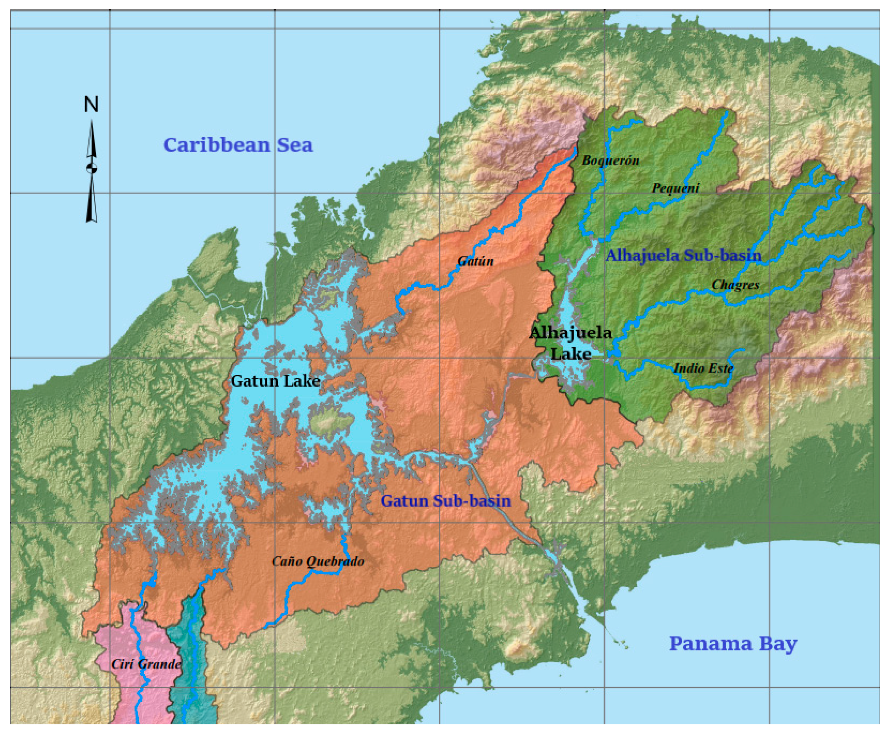
Figure 2.
Alhajuela Lake: Confluence of the Boquerón and Pequení rivers (From: Panama Canal Authority, 2013).
Figure 2.
Alhajuela Lake: Confluence of the Boquerón and Pequení rivers (From: Panama Canal Authority, 2013).
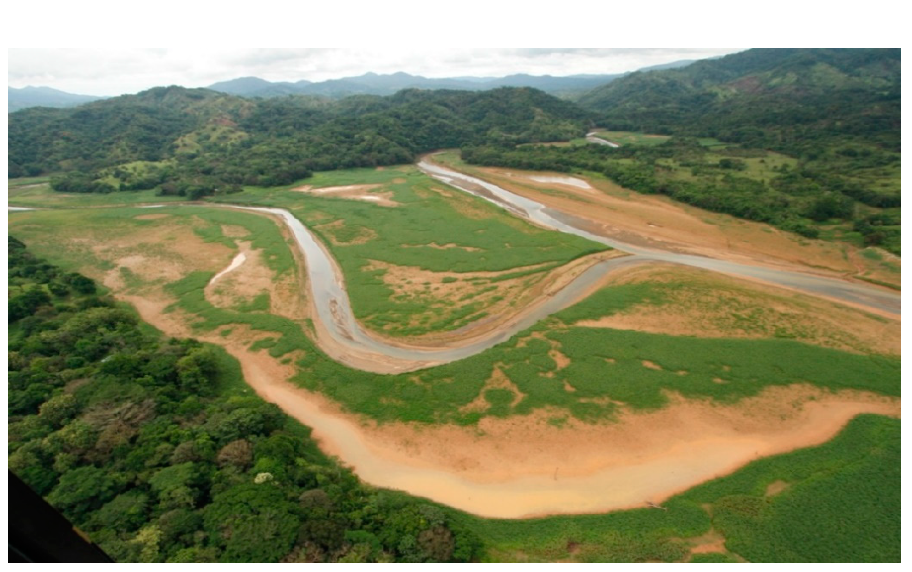
Figure 3.
Landslides and sediment transport in the rivers of the Alhajuela Lake sub-basin after the December 8, 2010 storm.
Figure 3.
Landslides and sediment transport in the rivers of the Alhajuela Lake sub-basin after the December 8, 2010 storm.
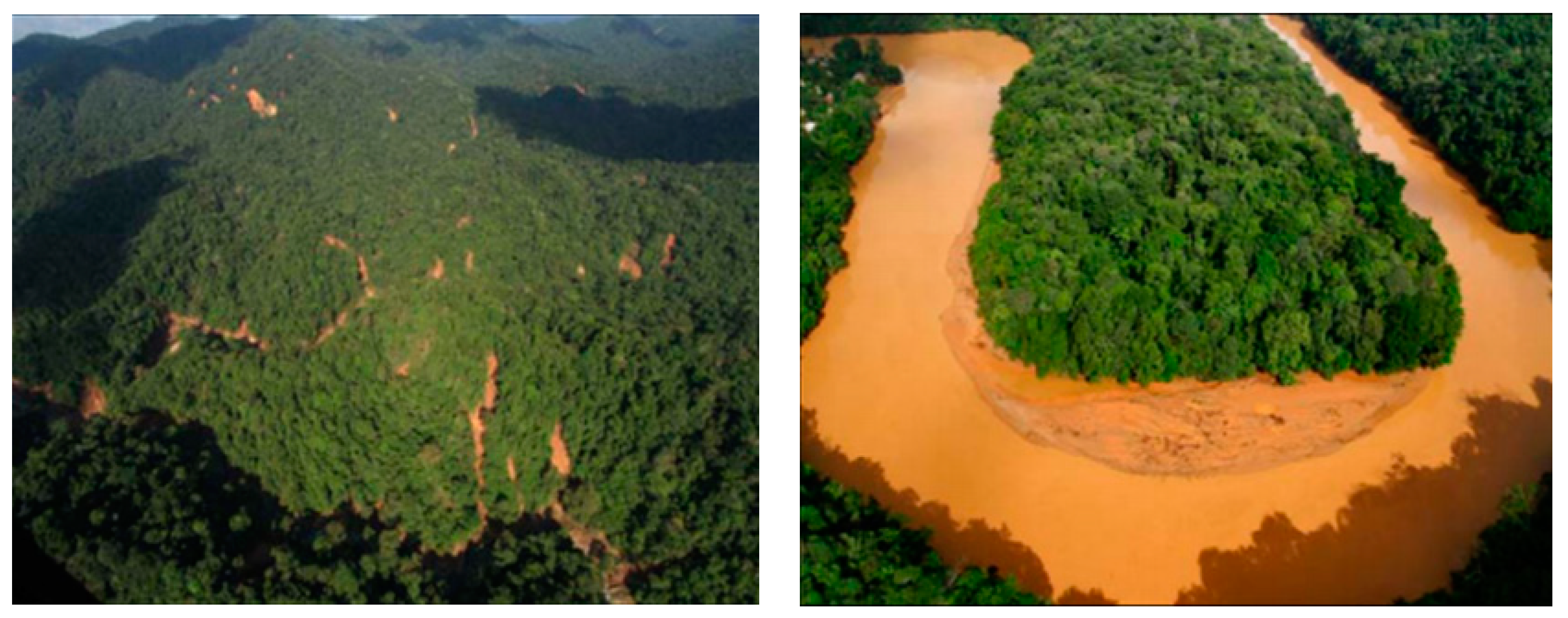
Figure 4.
Alhajuela Lake: Evolution of the 69 meter contour line from 1928 to 2012 (From: Panama Canal Authority, 2013).
Figure 4.
Alhajuela Lake: Evolution of the 69 meter contour line from 1928 to 2012 (From: Panama Canal Authority, 2013).
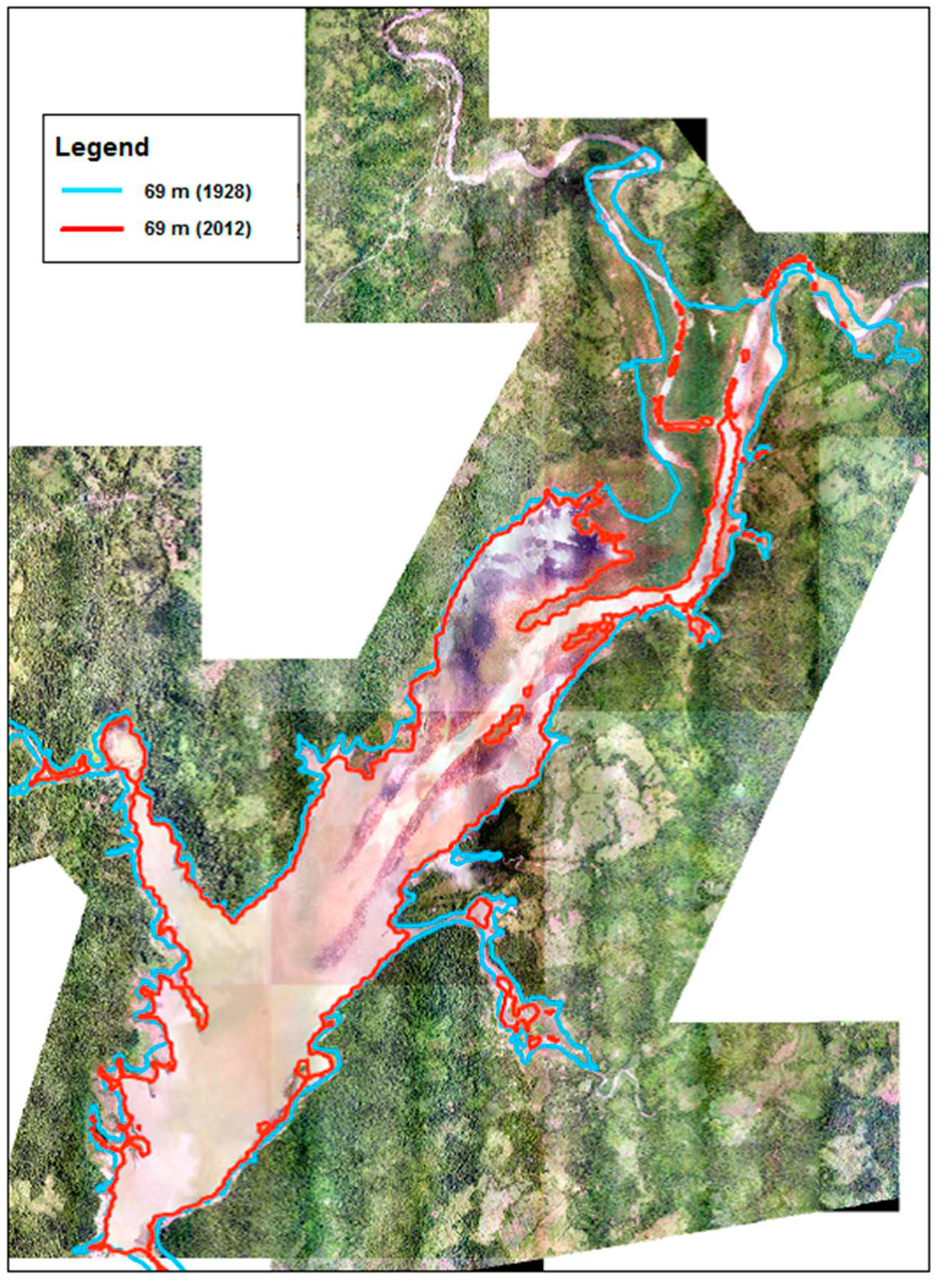
Figure 5.
Location of CSSI points in the study area.
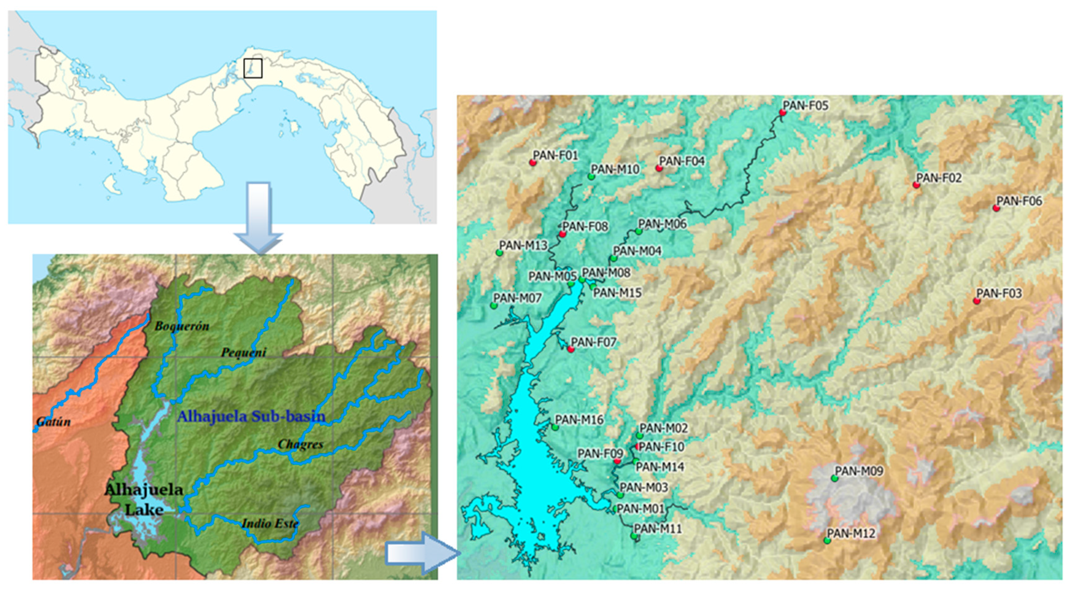
Figure 6.
Geographical relief of the study area.
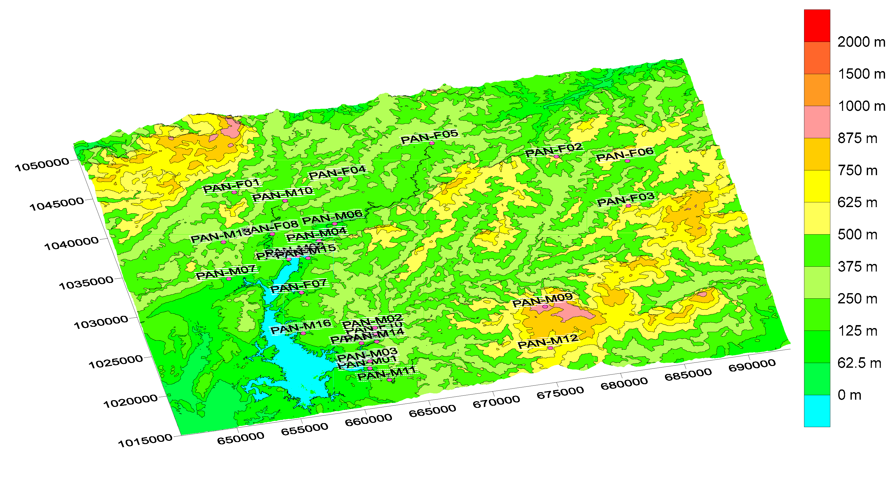
Figure 7.
Partial view of land use in the study area.
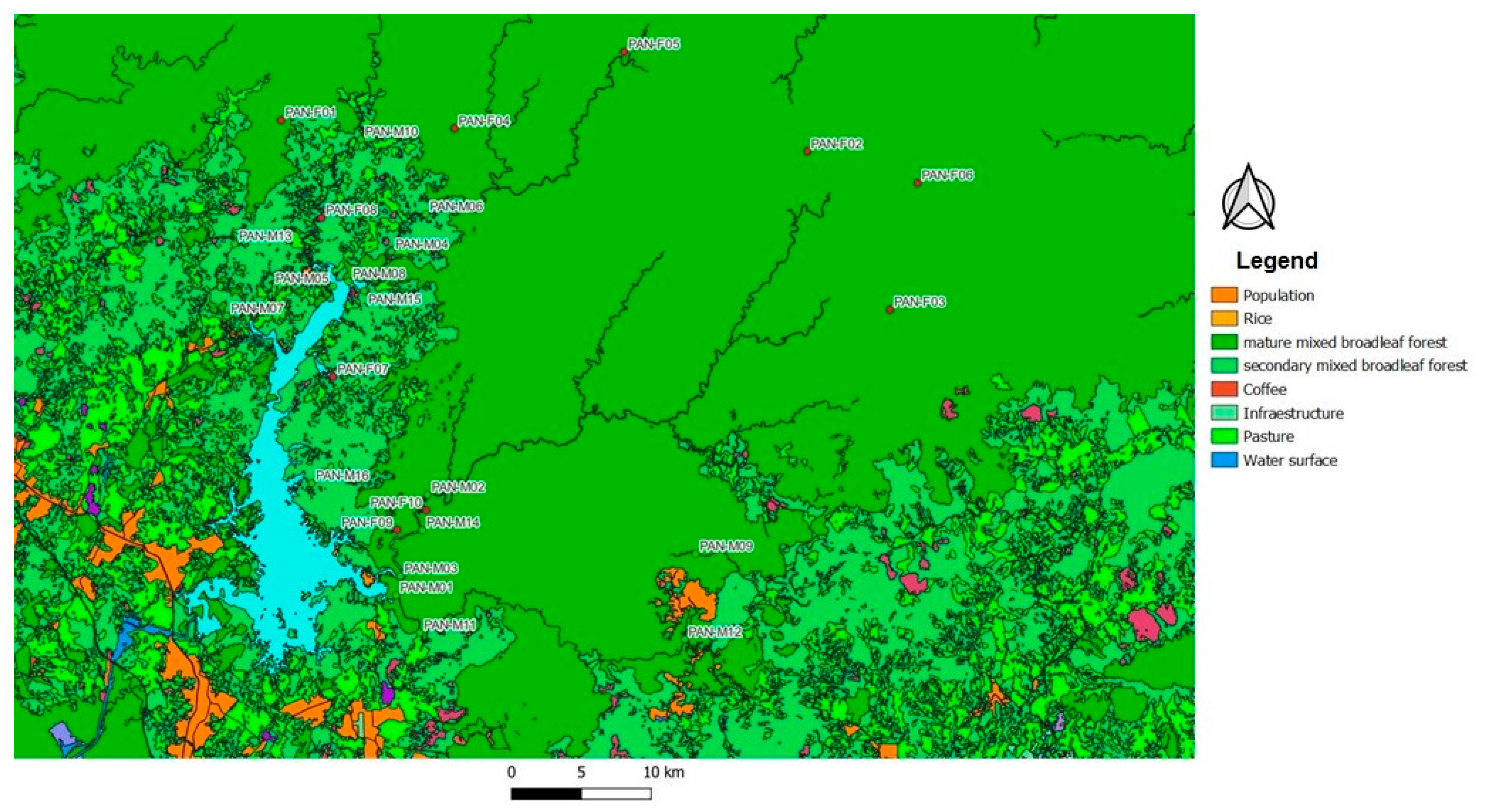
Figure 8.
Examples of box-plot graphs for variable selection.
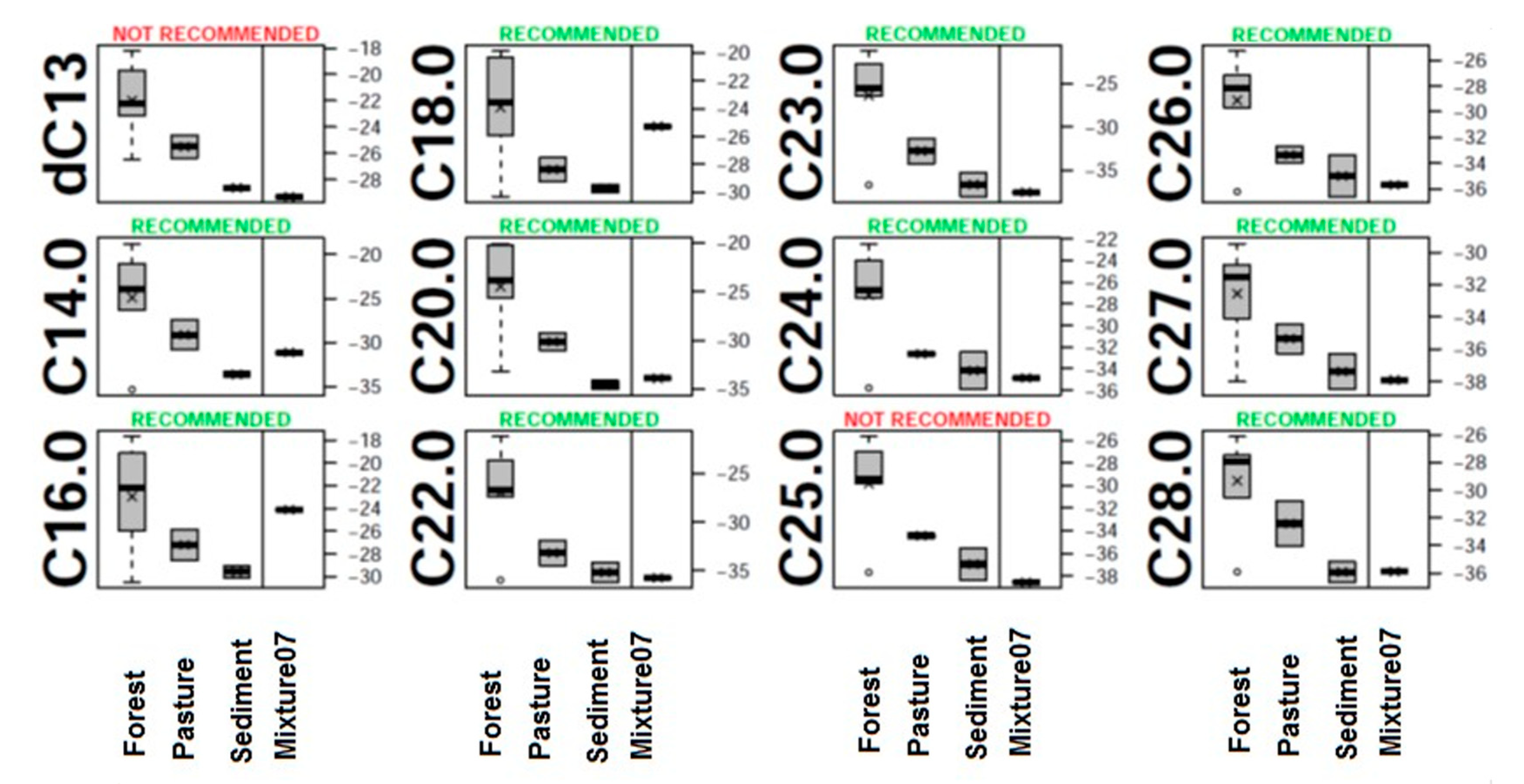
Figure 9.
Examples of resulting principal component analyses for mixtures 3 and 16.
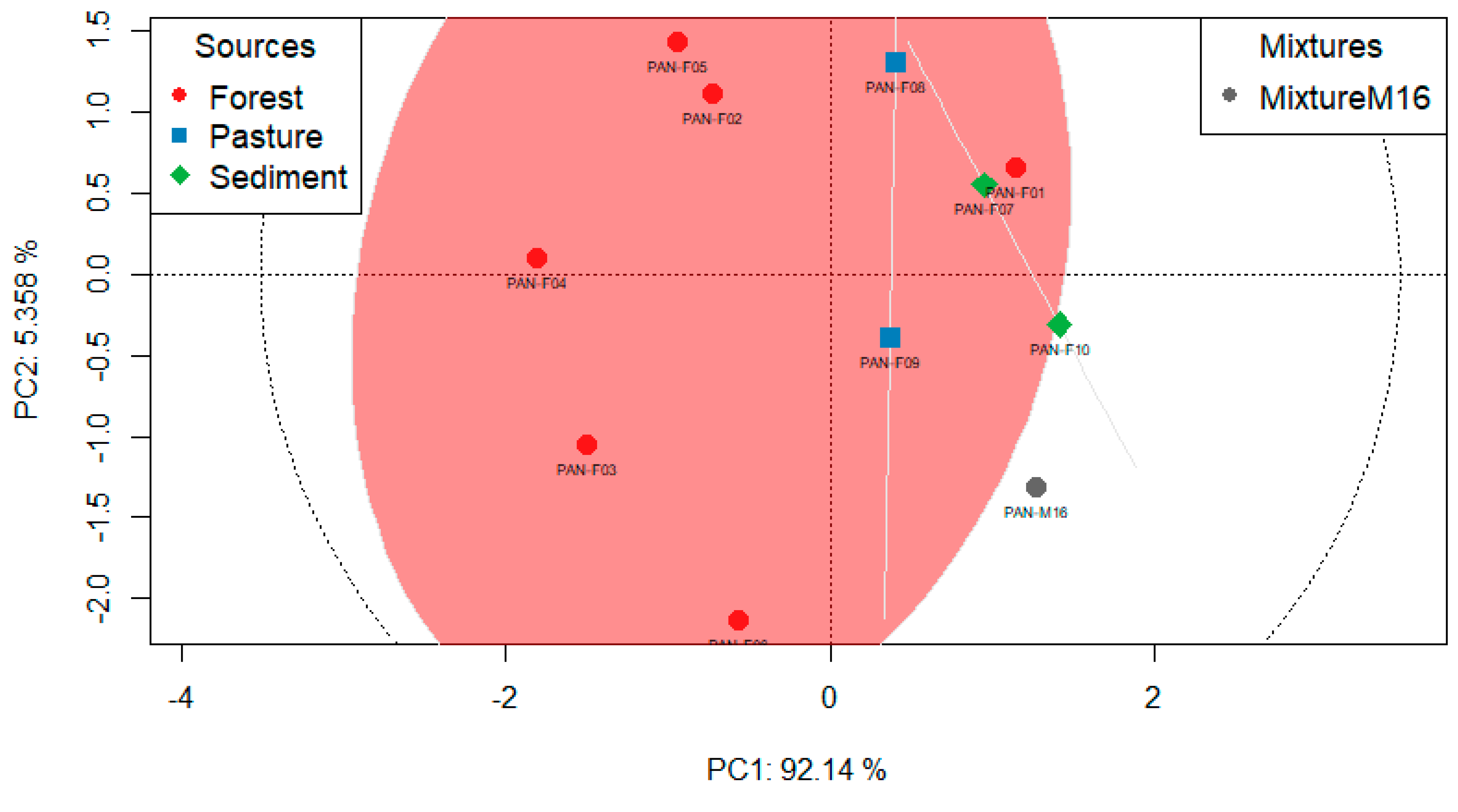
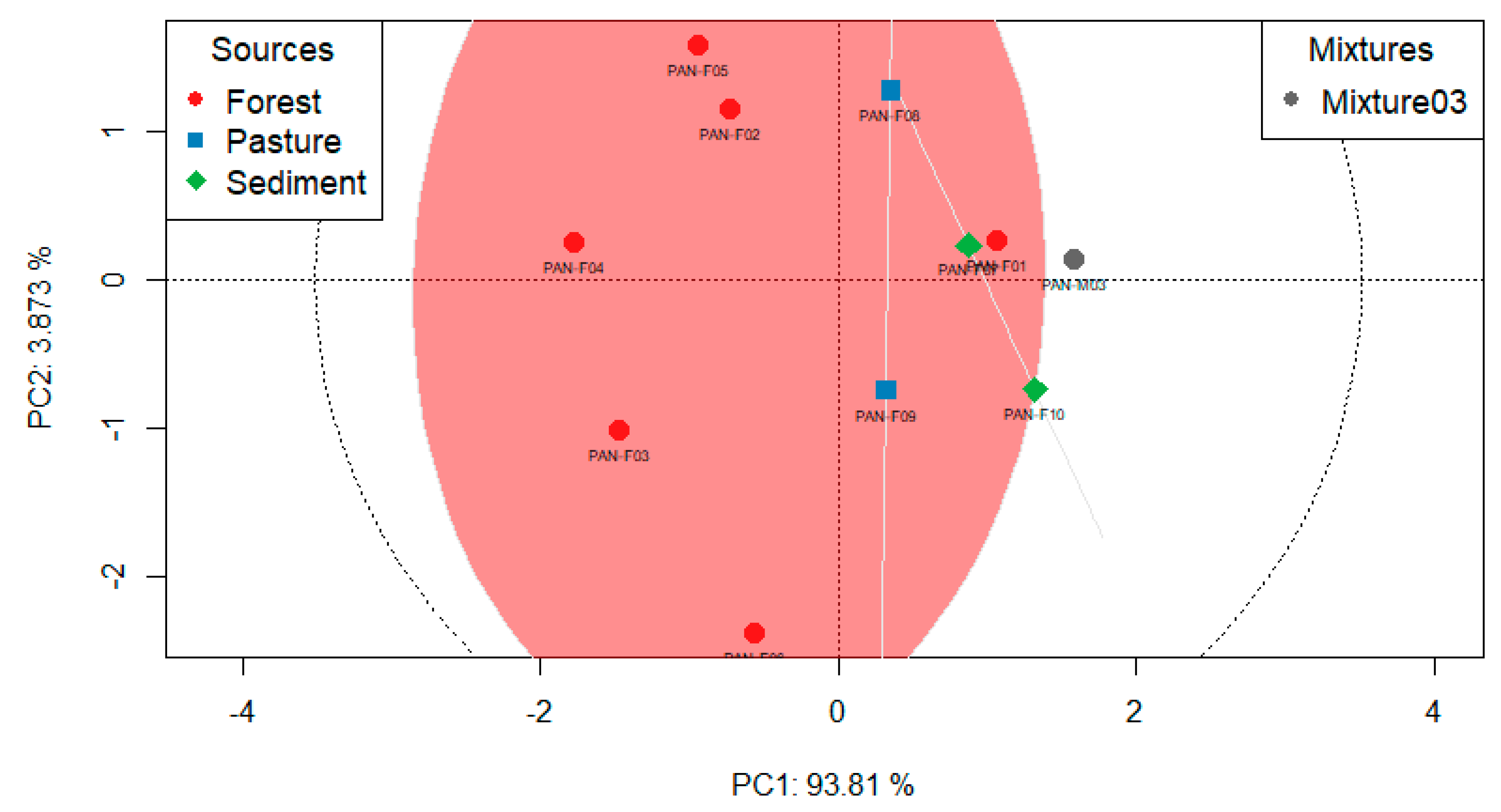
Figure 10.
Example of graphical output for Mixture 01 (contribution in mixtures and level of correlation between sources).
Figure 10.
Example of graphical output for Mixture 01 (contribution in mixtures and level of correlation between sources).
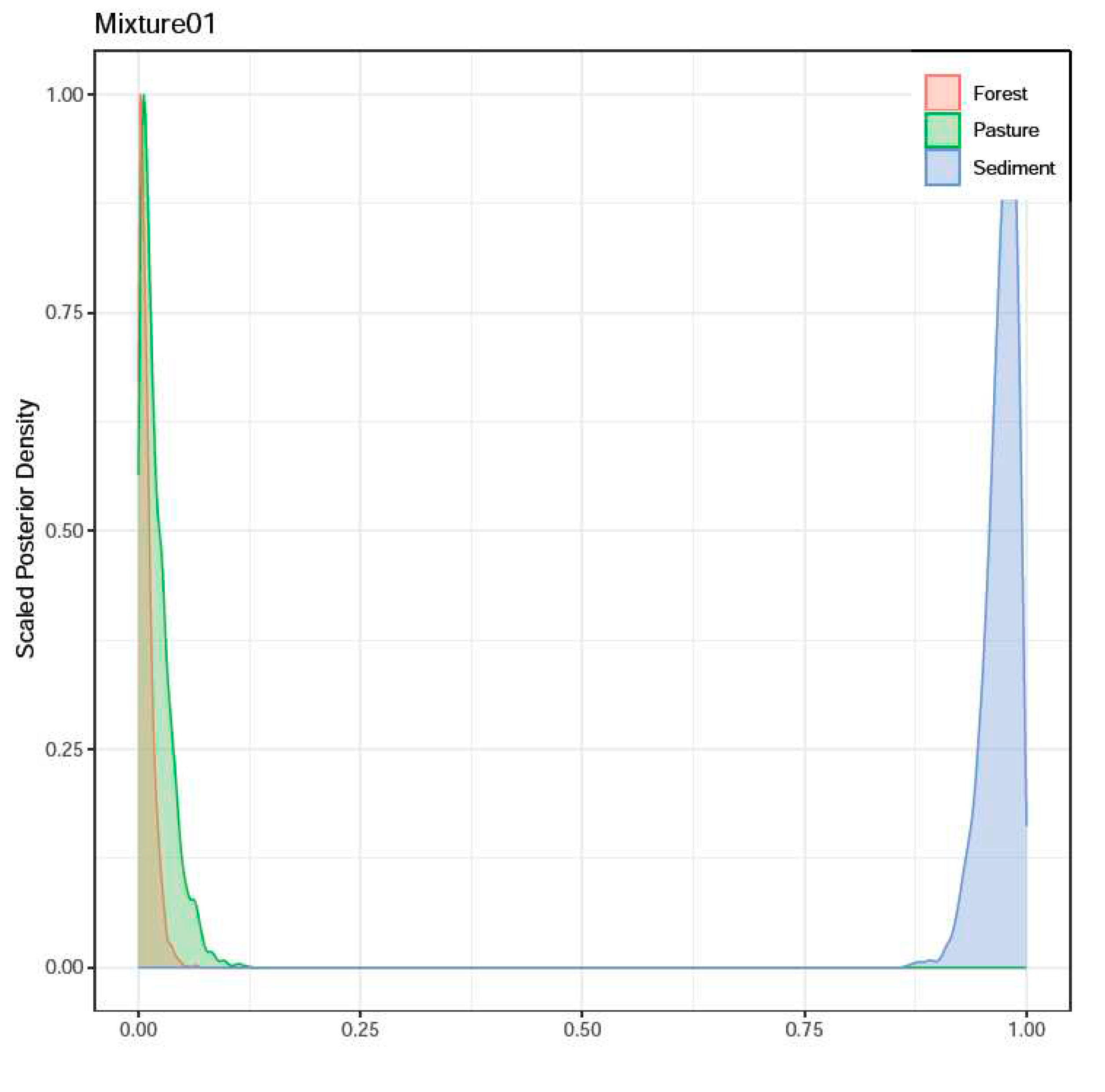
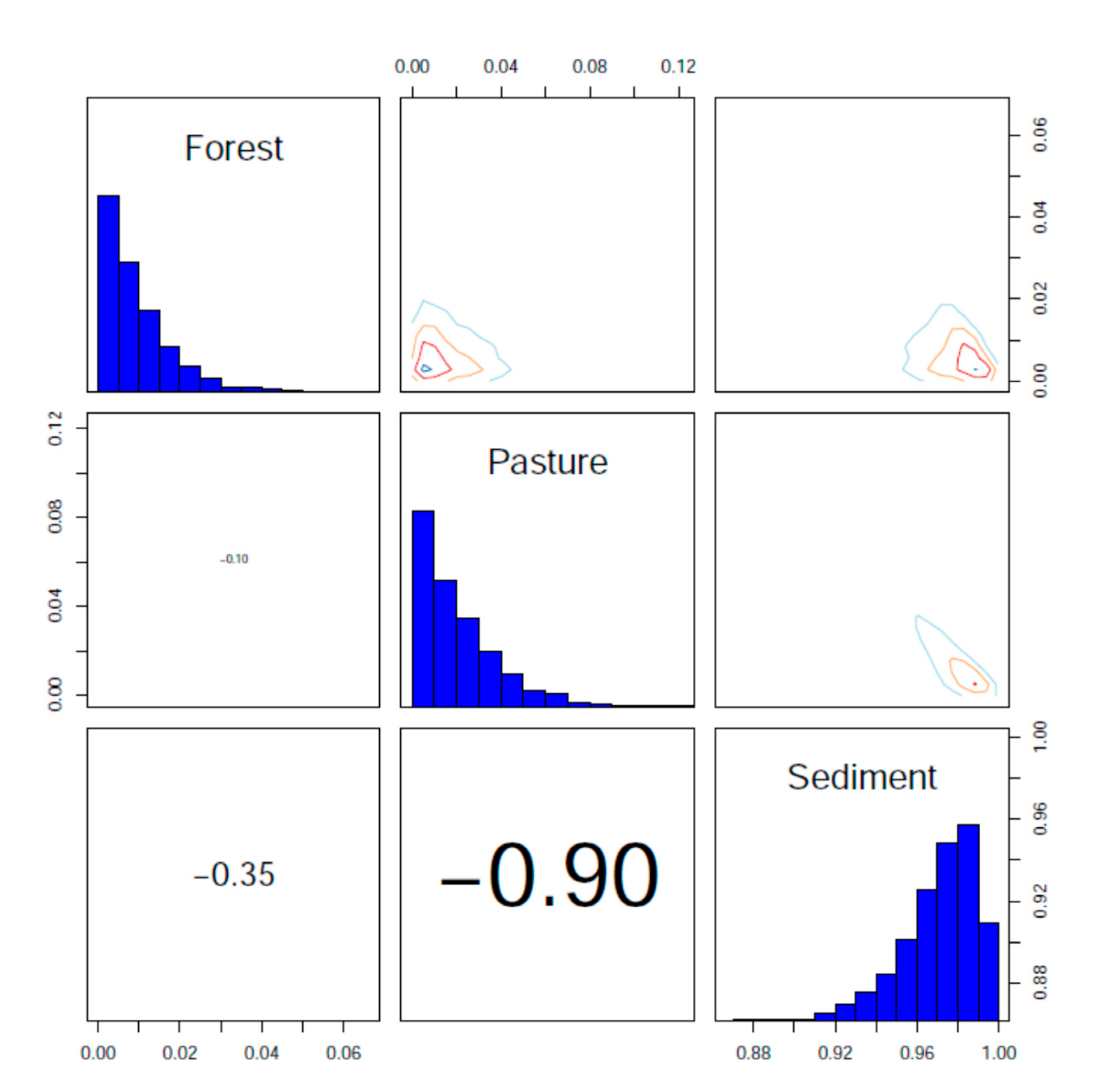
Figure 11.
Estimates of sediment contributions from evaluated sources.
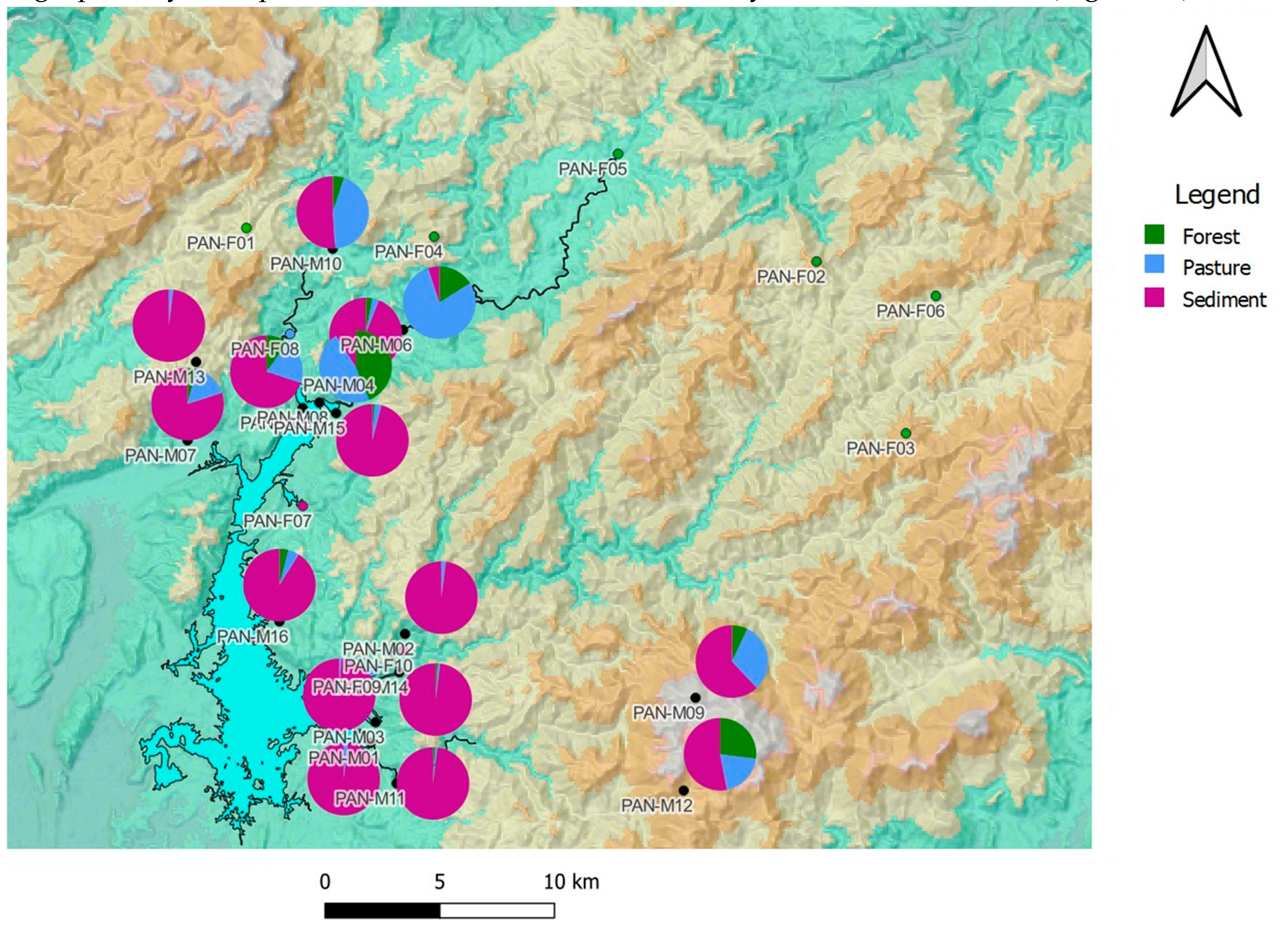
Figure 12.
Sediments accumulated in Alhajuela Lake between 2008-2012 (From: Panama Canal Authority, 2013).
Figure 12.
Sediments accumulated in Alhajuela Lake between 2008-2012 (From: Panama Canal Authority, 2013).
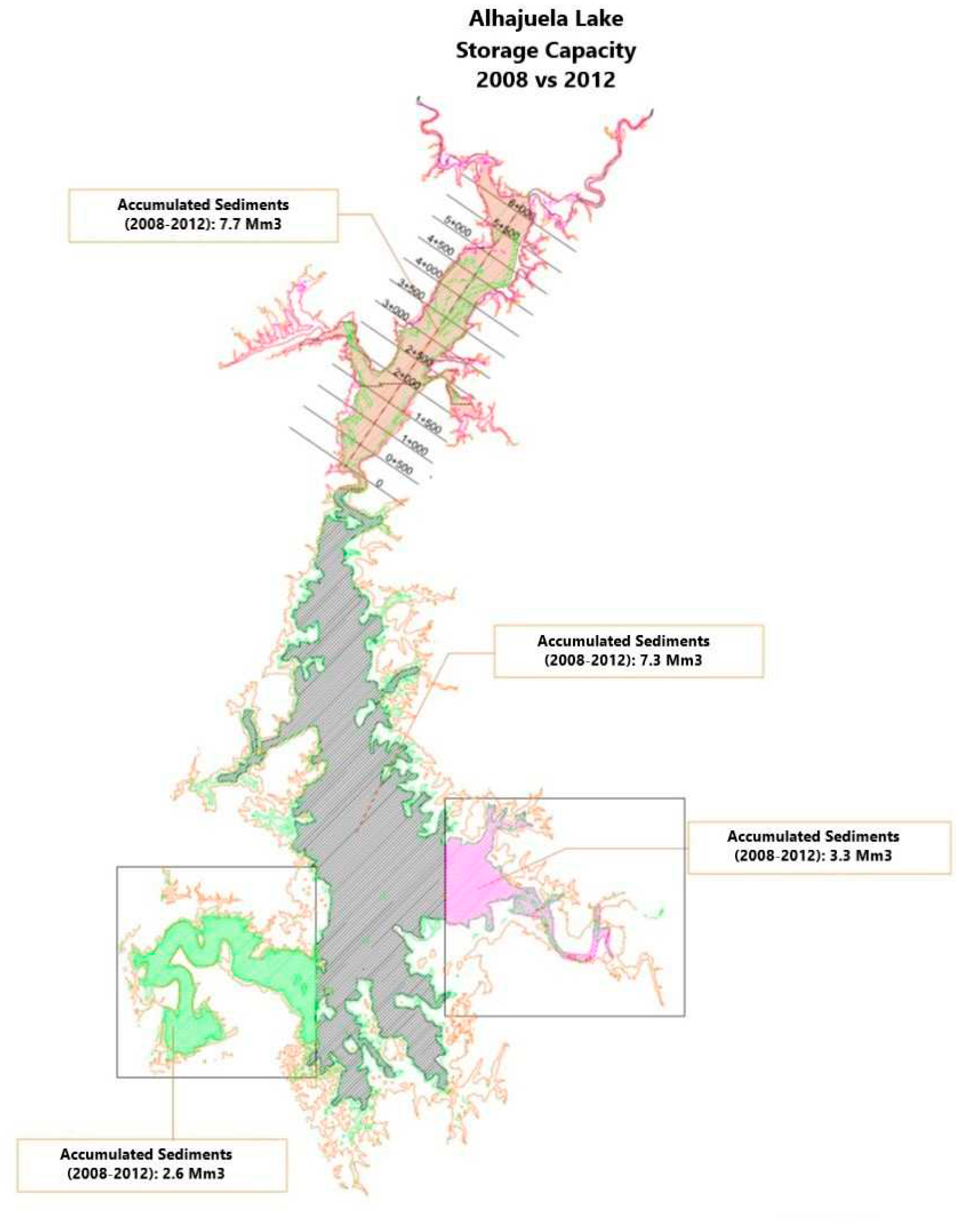

Table 1.
CSSI points sampled in Alhajuela sub-basin.
| Sample | Point | Coordinate E (UTM) | Coordinate N (UTM) | Elevation (m) | Observation | Code |
|---|---|---|---|---|---|---|
| 1 | Escandalosa | 656036 | 1042035 | 489 | upper part | PAN-F01 |
| 2 | Esperanza | 680898 | 1040569 | 552 | upper part | PAN-F02 |
| 3 | Chamón | 684799 | 1033081 | 656 | upper part | PAN-F03 |
| 4 | San Miguel | 664225 | 1041656 | 532 | upper part | PAN-F04 |
| 5 | Dos Bocas | 672246 | 1045265 | - | upper part | PAN-F05 |
| 6 | Chagresito | 686106 | 1039070 | 461 | upper part | PAN-F06 |
| 7 | Quebrada Ancha River | 658502 | 1029911 | 94 | lower part | PAN-F07 |
| 8 | Boquerón River Peluca Station | 657947 | 1037415 | 104 | upper middle part | PAN-F08 |
| 9 | La Fea River | 661522 | 1022680 | 128 | lower part | PAN-F09 |
| 10 | Chagres River CH1-2 | 662895 | 1023605 | 74 | upper middle part | PAN-F10 |
| 11 | Indio Este River INE 1 |
661468 | 1019588 | 75 | INE-1 river mouth |
PAN-M01 |
| 12 | Chagres River CH1-0 Indigenous Village |
662957 | 1024333 | 114 | middle part | PAN-M02 |
| 13 | Chagres River CH1 | 661670 | 1020488 | 72 | CH-1 | PAN-M03 |
| 14 | Chagres River CDL-2 | 661239 | 1035829 | 78 | CDL-2 | PAN-M04 |
| 15 | Boquerón River Mouth | 658493 | 1034183 | 72 | PEL-3 | PAN-M05 |
| 16 | Candelaria | 662870 | 1037590 | 90 | CDL-1 | PAN-M06 |
| 17 | Quebrada Bonita | 653470 | 1032773 | 101 | lower part | PAN-M07 |
| 18 | CDL-3 | 659219 | 1034420 | 70 | CDL-3 | PAN-M08 |
| 19 | Vistamares | 675625 | 1021547 | 944 | - | PAN-M09 |
| 20 | Santa Librada | 659803 | 1041130 | 136 | - | PAN-M10 |
| 21 | Guarumal | 662593 | 1017814 | 119 | - | PAN-M11 |
| 22 | INE-3 | 675109 | 1017504 | 592 | upper part | PAN-M12 |
| 23 | Santo Domingo | 653844 | 1036192 | 466 | upper part | PAN-M13 |
| 24 | La Palma River | 662709 | 1022661 | 107 | lower part | PAN-M14 |
| 25 | Monocongo River | 659952 | 1033962 | 90 | lower part | PAN-M15 |
| 26 | Benítez River | 657478 | 1024878 | 114 | lower part | PAN-M16 |
Table 2.
Isotopic ratio measurements of carbon chain fatty acids.
| Sam-ple | d13C | C14:0 | C15:0 | C16:0 | C17:0 | C18:0 | C19:0 | C20:0 | C21:0 | C22:0 | C23:0 | C24:0 | C25:0 | C26:0 | C27:0 | C28:0 | C29:0 | C30:0 | C31:0 | C32:0 | C33:0 | C34:0 |
|---|---|---|---|---|---|---|---|---|---|---|---|---|---|---|---|---|---|---|---|---|---|---|
| PAN-F01 | -26.45 | -35.31 | -31.32 | -30.5 | -30.31 | -32.72 | -33.18 | -35.97 | -36.71 | -35.78 | -37.7 | -36.21 | -38.01 | -35.91 | -37.42 | -35.5 | -37.91 | -36.03 | -38.42 | -35.87 | ||
| PAN-F02 | -23.16 | -26.2 | -25.98 | -25.88 | -24.77 | -27.38 | -25.73 | -26.74 | -29.41 | -28.64 | -31.5 | -27.94 | -33.12 | -29.75 | -33.36 | -32.18 | -33.28 | -30.82 | ||||
| PAN-F03 | -19.71 | -18.81 | -17.69 | -19.46 | -19.87 | -20.3 | -22.51 | -23.66 | -22.79 | -24 | -26.95 | -27.17 | -31.52 | -27.95 | -32.62 | -29.11 | -31.62 | -30.8 | -30.51 | -28.09 | ||
| PAN-F04 | -18.22 | -21.72 | -19.14 | -18.71 | -20.35 | -17.47 | -20.12 | -21 | -21.25 | -21.27 | -22.46 | -25.67 | -25.28 | -29.47 | -26.14 | -32 | -27.53 | -31.24 | -29.04 | -29.57 | -26.28 | |
| PAN-F05 | -21.28 | -26.33 | -25.54 | -24.6 | -24.06 | -25.32 | -24.31 | -25.61 | -27.15 | -26.41 | -26.67 | -29.51 | -27.71 | -30.76 | -27.5 | -32.67 | -29.09 | -32.94 | -31 | -31.24 | -28.68 | |
| PAN-F06 | -23.13 | -21.1 | -19.81 | -21.77 | -23.05 | -26.4 | -25.48 | -27.48 | -29.81 | -29.7 | -34.09 | -30.55 | -35.57 | -31.09 | -35.83 | -34.04 | -35.98 | -32.48 | ||||
| PAN-F07 | -28.71 | -33.31 | -31.46 | -30.1 | -31.55 | -29.42 | -27.56 | -34.15 | -35.61 | -34.17 | -35.24 | -32.45 | -35.56 | -33.38 | -36.28 | -35.18 | -37.14 | -36.88 | -37.28 | -36.57 | -38.24 | -35.64 |
| PAN-F08 | -26.36 | -30.77 | -29.82 | -28.56 | -29.83 | -29.22 | -31.4 | -31.04 | -35.36 | -34.48 | -34.22 | -32.54 | -34.31 | -32.7 | -34.44 | -30.8 | -34.78 | -33.68 | -35.47 | -34.39 | -36.51 | -34.48 |
| PAN-F09 | -24.64 | -27.45 | -28.06 | -25.85 | -28.95 | -27.51 | -29.1 | -29.25 | - | -31.91 | -31.36 | -32.72 | -34.58 | -34 | -36.26 | -34.05 | -36.53 | -34.53 | -36.28 | -34.62 | -36.11 | -33.29 |
| PAN-F10 | -28.53 | -33.89 | -31.71 | -29.05 | -32.17 | -29.99 | -33.54 | -35.05 | -37.37 | -36.2 | -38.05 | -35.92 | -38.38 | -36.6 | -38.5 | -36.67 | -38.63 | -37.57 | -38.81 | -37.56 | -39.81 | -37.92 |
| PAN-M01 | -28.46 | -34.37 | -32.86 | -29.38 | -33.22 | -30.98 | -35.02 | -35.36 | -36.68 | -36.72 | -37.84 | -36.34 | -38.08 | -36.55 | -37.87 | -36.88 | -38.78 | -37.37 | -39.43 | -37.93 | -40.54 | -39.15 |
| PAN-M02 | -28.73 | -31.96 | -33.09 | -30.2 | -34.07 | -31.16 | -33.73 | -36.8 | -38.99 | -36.99 | -38.97 | -36.96 | -38.67 | -36.34 | -37.45 | -36.36 | -38.5 | -37.31 | -39.56 | -37.9 | -40.67 | -39.07 |
| PAN-M03 | -28.85 | -36.01 | -35.62 | -34.67 | -36.01 | -33.66 | -35.02 | -35.86 | -36.18 | -37.9 | -35.26 | -38.65 | -36.86 | -38.78 | -37.23 | -39.19 | -37.8 | -39.75 | -38.14 | -40.72 | -39.5 | |
| PAN-M04 | -29.44 | -32.63 | -34.13 | -27.91 | -33.95 | -28.86 | -32.71 | -36.7 | -38.63 | -36.58 | -38.81 | -36.85 | -38.97 | -37.28 | -37.92 | -36.72 | -38.56 | -37.44 | -38.56 | -37.69 | -40.37 | -39.02 |
| PAN-M05 | -27.34 | -31.84 | -30.4 | -26.58 | -30.96 | -28.64 | -31.52 | -32.16 | -34.84 | -34.55 | -35.56 | -34.47 | -37.04 | -36.08 | -37.61 | -35.88 | -38.35 | -36.2 | -38.6 | -36.46 | -39.04 | -35.85 |
| PAN-M06 | -25.35 | -27.55 | -28.33 | -23.3 | -29.09 | -27.11 | -29.07 | -32.61 | -32.9 | -32.05 | -31.94 | -33.94 | -32.13 | -34.3 | -31.72 | -35.19 | -33.55 | -35.23 | -34.16 | -35.76 | -32.76 | |
| PAN-M07 | -29.29 | -31.11 | -31.25 | -24.11 | -31.91 | -25.27 | -33.39 | -33.91 | -37.69 | -35.73 | -37.54 | -34.85 | -38.58 | -35.69 | -37.91 | -35.89 | -38.13 | -36.18 | -38.63 | -36.47 | -40.2 | -38.21 |
| PAN-M08 | -25.77 | -28.73 | -28.39 | -22.85 | -29.84 | -26 | -29.71 | -30.06 | -33.11 | -32.56 | -32.93 | -30.94 | -33.13 | -31.22 | -33.55 | -30.67 | -34.08 | -31.93 | -33.55 | -31.53 | -34.64 | -30.85 |
| PAN-M09 | -27.32 | -31.12 | -30.29 | -24.96 | -31.8 | -28.29 | -33.05 | -32.26 | -35.57 | -34.67 | -35.66 | -33.81 | -36.87 | -34.65 | -37.07 | -34.64 | -37.56 | -35.59 | -37.64 | -35.36 | -39.25 | -35.35 |
| PAN-M10 | -25.54 | -30.54 | -29.97 | -28.04 | -29.68 | -29.68 | -31.43 | -31.69 | -34 | -34.28 | -34.75 | -33.37 | -36.17 | -34.48 | -36.3 | -33.93 | -36.77 | -35.54 | -36.74 | -35.73 | -38.61 | -36.83 |
| PAN-M11 | -28.69 | -33.71 | -32.67 | -28.9 | -33.02 | -30.42 | - | -35.27 | -38.58 | -35.73 | -37.81 | -34.97 | -38.91 | -36.54 | -38.4 | -36.64 | -38.34 | -37.06 | -39.2 | -37.33 | -40.77 | -38.37 |
| PAN-M12 | -28.44 | -29.88 | -30.11 | -22.55 | -30.84 | -26.09 | -31.73 | -31.06 | -38.38 | -34.43 | -34.81 | -32.75 | -36.41 | -34.63 | -37.17 | -34.4 | -36.74 | -33.63 | -37.32 | -34.27 | -40.03 | -35.96 |
| PAN-M13 | -27.61 | -30.88 | -30.17 | -27.81 | -31.03 | -31 | - | -36.8 | -37.2 | -37.55 | -38.85 | -37.43 | -39.02 | -37.21 | -38.59 | -36.4 | -38.97 | -37.76 | -40.26 | -38.15 | -40.96 | -38.33 |
| PAN-M14 | -28.91 | -32.47 | -31.72 | -27.96 | -33.75 | -32.22 | -35.09 | -36.9 | -39.67 | -37.1 | -39.38 | -36.68 | -39.89 | -37.21 | -39.33 | -37.19 | -39.3 | -38.05 | -39.64 | -37.37 | -40.93 | -39.15 |
| PAN-M15 | -29.16 | -32.46 | -32.89 | -25.73 | -32.66 | -29.95 | -46.04 | -36.05 | -37.93 | -36.59 | -38.93 | -36.95 | -40.02 | -37.24 | -38.75 | -37.02 | -38.87 | -37.05 | -39.25 | -36.94 | -40.5 | -37.88 |
| PAN-M16 | -28.17 | -31.26 | -31.07 | -25.19 | -31.67 | -28.86 | -33.08 | -34.62 | -35.35 | -37.48 | -35.14 | -38.04 | -36.05 | -38.03 | -34.79 | -38.13 | -37.14 | -39.35 | -38.39 | -40.73 | -39.89 |
Table 3.
Land uses identified for CSSI sampling points.
| Point | Sample | Land Use |
|---|---|---|
| Escandalosa | PAN-F01 | Mature mixed broadleaf forest |
| Esperanza | PAN-F02 | Mature mixed broadleaf forest |
| Chamón | PAN-F03 | Mature mixed broadleaf forest |
| San Miguel | PAN-F04 | Mature mixed broadleaf forest |
| Dos Bocas | PAN-F05 | Mature mixed broadleaf forest |
| Changresito | PAN-F06 | Mature mixed broadleaf forest |
| Quebrada Ancha River | PAN-F07 | Water surface |
| Boquerón River Peluca Station | PAN-F08 | Pasture |
| La Fea River | PAN-F09 | Pasture |
| Changres River CH1-2 | PAN-F10 | Water surface |
| Indio Este River INE 1 | PAN-M01 | Water surface |
| Chagres River CH1-0 Indigenous Village |
PAN-M02 | Mature mixed broadleaf forest |
| Chagres River CH1 | PAN-M03 | Mature mixed broadleaf forest |
| Chagres River CDL-2 | PAN-M04 | Water surface |
| Boquerón River Mouth | PAN-M05 | Water surface |
| Candelaria | PAN-M06 | Water surface |
| Quebrada Bonita | PAN-M07 | Pasture |
| CDL-3 | PAN-M08 | Water surface |
| Vistamares | PAN-M09 | Mature mixed broadleaf forest |
| Santa Librada | PAN-M10 | Secondary mixed broadleaf forest |
| Guarumal | PAN-M11 | Mature mixed broadleaf forest |
| INE-3 | PAN-M12 | Mature mixed broadleaf forest |
| Santo Domingo | PAN-M13 | Pasture |
| La Palma River | PAN-M14 | Water surface |
| Monocongo River | PAN-M15 | Water surface |
| Benítez River | PAN-M16 | Water surface |
Table 4.
Variables not recommended for the runs.
| Mixture | Variables not recommended |
|---|---|
| Mixture 1 | C14,C18,C20;C22,C24,C28,C29,C31,C32,C33,C34 |
| Mixture 2 | dC13,C16,C18,C20;C22,C23,C24,C25,C31,C32,C33,C34 |
| Mixture 3 | dC13,C14,C16,C18,C20,C25,C26,C27,C28,C29,C30,C31,C32,C33,C34 |
| Mixture 4 | dC13,C20,C22,C23,C24,C25,C26,C28,C32,C33,C34 |
| Mixture 5 | - |
| Mixture 6 | - |
| Mixture 7 | dC13,C25,C33,C34 |
| Mixture 8 | - |
| Mixture 9 | - |
| Mixture 10 | - |
| Mixture 11 | C18,C20,C25,C31,C33,C34 |
| Mixture 12 | C33 |
| Mixture 13 | C18,C20,C22,C23,C24,C25,C26,C27,C29.,C30,C31,C32,C33,C34 |
| Mixture 14 | dC13,C18,C20,C22,C23,C24,C25,C26,C27,C28,C29,C30,C31,C33,C34 |
| Mixture 15 | dC13, C20,C22,C23,C24,C25,C26,C27,C28,C29, C31,C33 |
| Mixture 16 | C31,C32,C33,C34 |
Table 5.
Estimates of source contribution levels and correlations.
| Mixture | Contributions of land uses to the mixtures (%) | Strong correlations | Correlation index | |||||
|---|---|---|---|---|---|---|---|---|
| Forest | SD* | Pasture | SD* | Sediment | SD* | |||
| PAN-M01 | 0 | 0.8 | 2 | 1.7 | 98 | 1.8 | Sediment/Pasture | -0.90 |
| PAN-M02 | 0 | 0.9 | 2 | 2.0 | 98 | 2.0 | Sediment/Pasture | -0.90 |
| PAN-M03 | 0 | 0.6 | 1 | 1.3 | 99 | 1.5 | Sediment/Pasture | -0.89 |
| PAN-M04 | 3 | 1.8 | 3 | 3.2 | 94 | 3.7 | Sediment/Pasture | -0.88 |
| PAN-M05 | 10 | 4.3 | 20 | 9.7 | 70 | 6.5 | Sediment/Pasture Pasture/Forest Sediment/Forest |
-0.93 -0.89 0.59 |
| PAN-M06 | 16 | 6.0 | 79 | 11.0 | 5 | 6.2 | Sediment/Pasture Pasture/Forest Sediment/Forest |
-0.90 -0.89 0.61 |
| PAN-M07 | 4 | 4.9 | 16 | 9.3 | 80 | 7.0 | Sediment/Pasture Pasture/Forest | -0.86 -0.67 |
| PAN-M08 | 44 | 8.8 | 47 | 15.0 | 9 | 9.3 | Sediment/Pasture Pasture/Forest | -0.84 -0.82 |
| PAN-M09 | 7 | 5.3 | 31 | 12.2 | 62 | 8.3 | Sediment/Pasture Pasture/Forest Sediment/Forest |
-0.94 -0.84 0.60 |
| PAN-M10 | 5 | 4.8 | 44 | 1.0 | 51 | 6.9 | Sediment/Pasture Pasture/Forest Sediment/Forest | -0.91 -0.81 0.51 |
| PAN-M11 | 1 | 0.8 | 1 | 1.9 | 98 | 1.9 | Sediment/Pasture | -0.91 |
| PAN-M12 | 27 | 9.1 | 20 | 18.6 | 53 | 12.2 | Sediment/Pasture Pasture/Forest | -0.91 -0.83 |
| PAN-M13 | 0 | 1.1 | 2 | 2.2 | 98 | 2.4 | Sediment/Pasture | -0.88 |
| PAN-M14 | 1 | 1.1 | 1 | 2.2 | 98 | 2.4 | Sediment/Pasture | -0.89 |
| PAN-M15 | 1 | 1.4 | 3 | 3.3 | 96 | 3.4 | Sediment/Pasture | -0.91 |
| PAN-M16 | 4 | 2.8 | 5 | 4.8 | 91 | 4.1 | Sediment/Pasture Pasture/Forest | -0.81 -0.52 |
*SD, standard deviation.
Disclaimer/Publisher’s Note: The statements, opinions and data contained in all publications are solely those of the individual author(s) and contributor(s) and not of MDPI and/or the editor(s). MDPI and/or the editor(s) disclaim responsibility for any injury to people or property resulting from any ideas, methods, instructions or products referred to in the content. |
© 2023 by the authors. Licensee MDPI, Basel, Switzerland. This article is an open access article distributed under the terms and conditions of the Creative Commons Attribution (CC BY) license (http://creativecommons.org/licenses/by/4.0/).
Copyright: This open access article is published under a Creative Commons CC BY 4.0 license, which permit the free download, distribution, and reuse, provided that the author and preprint are cited in any reuse.


