Submitted:
04 September 2023
Posted:
08 September 2023
You are already at the latest version
Abstract
Keywords:
Introduction
1.1. Land-based conservation
1.2. Participatory science and landscape
1.3. Geopolitical context
1.4. Objectives
2. Methods
2.1. Study area
2.2. Macroregional state level
2.3. Microregional level
2.4. Efficiency assessment of the Zicuirán-Infiernillo Biosphere Reserve
3. Results
3.1. The State System of Conservation

3.2. Zicuirán-Infiernillo Biosphere Reserve consultation
3.3. Biosphere reserve model efficiency
4. Discussion
4.1. Multiscale integration
4.2. From state to national scale
Author Contributions
Declarations
Acknowledgments
Competing Interests
Appendix A
| ID |
AGRARIAN COMMUNITY |
MUNICIPALITY | DATE OF THE ASAMBLIES (S) |
CORE ZONE FIRST PROPOSAL |
CORE ZONE SECOND PROPOSAL |
CONSENSUAL CORE ZONE | MEAN OF AGREEMENT | |
| 1 | AGUA NUEVA | CHURUMUCO | 05 OF MAY | X | ASSEMBLY MINUTE | |||
| 26 OF MAY | ASSEMBLY MINUTE | |||||||
| 2 | ARRONJADERO | LA HUACANA | 15 MARCH | X | ASSEMBLY MINUTE | |||
| 04 OF MAY | ASSEMBLY MINUTE | |||||||
| 11 OF MAY | ASSEMBLY MINUTE | |||||||
| 3 | CAJA DE ZICUIRAN | LA HUACANA | 4 OF MARCH | X | ASSEMBLY MINUTE | |||
| CAYACO | LA HUACANA | 11 OF MARCH | X | X | X | ASSEMBLY MINUTE | ||
| 29 OF APRIL | ASSEMBLY MINUTE | |||||||
| 4 | CERRO DE LA LUMBRE | ARTEAGA | 14 OF APRIL | X | ASSEMBLY MINUTE | |||
| 5 | CHURUMUCO Y ANX. LAS PILAS Y TIMBIRICHE | CHURUMUCO | 6; 14, 16 OF MARCH | X | ASSEMBLY MINUTE | |||
| 5 OF APRIL | ASSEMBLY MINUTE | |||||||
| 28 OF APRIL | ASSEMBLY MINUTE | |||||||
| 6 | COL. FRANCISCO VILLA | LA HUACANA | 25 OF MARCH | X | ASSEMBLY MINUTE | |||
| 1 OF APRIL | ASSEMBLY MINUTE | |||||||
| 7 | COLONIA LAZARO CARDENAS | LA HUACANA | 11 OF MARCH | X | X | X | ASSEMBLY MINUTE | |
| 8 | CONGURIPO | LA HUACANA | 19 OF MARCH | X | X | X | ASSEMBLY MINUTE | |
| 25 OF MARCH | ASSEMBLY MINUTE | |||||||
| 1 OF APRIL | ASSEMBLY MINUTE | |||||||
| 9 | CUIMBO Y ANX. | LA HUACANA | 1ª. 2 MARCH | X | X | X | ASSEMBLY MINUTE | |
| 2ª. 29 APRIL | ASSEMBLY MINUTE | |||||||
| 10 | CUNUATO | CHURUMUCO | 15 OF APRIL | X | ASSEMBLY MINUTE | |||
| 13 OF MAY | ASSEMBLY MINUTE | |||||||
| 2 OF JUNE | ASSEMBLY MINUTE | |||||||
| 6 OF JUNE | ASSEMBLY MINUTE | |||||||
| 11 | DOTACION CUERAMATO | CHURUMUCO | 31 OF MAY | X | ASSEMBLY MINUTE | |||
| 12 | EL AHUIJOTE | CHURUMUCO | 27 OF MAY | X | ASSEMBLY MINUTE | |||
| 13 | EL ALGODÓN Y OROPEO Y ANX. | LA HUACANA | 5 OF MARCH | X | X | ASSEMBLY MINUTE | ||
| 14 | EL CASCALOTE | ARTEAGA | 11 OF APRIL | X | ASSEMBLY MINUTE | |||
| 15 OF APRIL | ASSEMBLY MINUTE | |||||||
| 15 | EL CHAUZ | LA HUACANA | 11 OF MARCH | X | ASSEMBLY MINUTE | |||
| 25 OF MARCH | ASSEMBLY MINUTE | |||||||
| 4 OF MARCH | ASSEMBLY MINUTE | |||||||
| 16 | EL CHILAR | LA HUACANA | 27 OF APRIL | X | ASSEMBLY MINUTE | |||
| 17 | EL PALMAR Y ANX. (MESA DE VICENTELO PUERTA) | LA HUACANA | 9 OF MARCH | X | ASSEMBLY MINUTE | |||
| 28 OF APRIL | ASSEMBLY MINUTE | |||||||
| 18 | EL SAUZ | ARTEAGA | 14 OF APRIL | X | ASSEMBLY MINUTE | |||
| 19 | EL TERRERO | LA HUACANA | 14 APRIL | X | X | X | ASSEMBLY MINUTE | |
| 20 | GENERAL LAZARO CARDENAS (CIRIANCITOS) | LA HUACANA | 4 OF MARCH | X | ASSEMBLY MINUTE | |||
| 1 OF APRIL | ASSEMBLY MINUTE | |||||||
| 7 OF APRIL | ASSEMBLY MINUTE | |||||||
| 21 | GUADALPE OROPEO Y ANX. LAS CRUCECITAS | LA HUACANA | 1 OF MARCH | X | ASSEMBLY MINUTE | |||
| 4 OF MARCH | ASSEMBLY MINUTE | |||||||
| 22 | HUATZIRAN Y ANEXOS (LAS VACAS Y LOS PLACERES) | LA HUACANA | 18 OF FEB. | X | X | X | ASSEMBLY MINUTE | |
| 6 OF MARCH | ASSEMBLY MINUTE | |||||||
| 22 OF APRIL | ASSEMBLY MINUTE | |||||||
| 23 | ICHAMIO Y ANX. EL TIZATAL | LA HUACANA | 4 OF MARCH | X | X | X | ASSEMBLY MINUTE | |
| 24 | LA HIGUERITA Y ANX. (EL PASEO) | CHURUMUCO | 26 OF MAY | ASSEMBLY MINUTE | ||||
| 25 | LA HUACANA | LA HUACANA | 22 OF MARCH | X | X | X | ASSEMBLY MINUTE | |
| 15 OF APRIL | ASSEMBLY MINUTE | |||||||
| 22 OF APRIL | ASSEMBLY MINUTE | |||||||
| 26 | LA LOMA | CHURUMUCO | 11 OF APRIL | ASSEMBLY MINUTE | ||||
| 27 | LA PAREJA | ARTEAGA | 11 OF APRIL | X | ASSEMBLY MINUTE | |||
| 28 | LA PITIRERA | ARTEAGA | 14 OF APRIL | X | ASSEMBLY MINUTE | |||
| ASSEMBLY MINUTE | ||||||||
| 29 | LA VINATA | ARTEAGA | 1 OF APRIL | X | X | X | ASSEMBLY MINUTE | |
| 30 | LAS ANONAS Y ANX. | LA HUACANA | 29 OF APRIL | X | ASSEMBLY MINUTE | |||
| 31 | LAS CARAMICUAS | TUMBISCATIO | 27 OF MAY | X | ASSEMBLY MINUTE | |||
| 3 OF JUNE | ASSEMBLY MINUTE | |||||||
| 9 OF JUNE | ASSEMBLY MINUTE | |||||||
| 32 | LAS CRUCES | TUMBISCATIO | 27 OF MAY | X | ASSEMBLY MINUTE | |||
| 3 OF JUNE | ASSEMBLY MINUTE | |||||||
| 9 OF JUNE | ASSEMBLY MINUTE | |||||||
| 33 | LAS ESTANCIAS | LA HUACANA | 10 OF MARCH | X | ASSEMBLY MINUTE | |||
| 20 OF MARCH | ASSEMBLY MINUTE | |||||||
| 34 | LAS PILAS | CHURUMUCO | 26 OF MAY | X | ASSEMBLY MINUTE | |||
| 35 | LAS TAMACUAS | LA HUACANA | 28 OF APRIL | X | X | ASSEMBLY MINUTE | ||
| 4 OF MAY | ASSEMBLY MINUTE | |||||||
| 36 | LIMON DE JORULLO | LA HUACANA | 13 OF APRIL | X | X | ASSEMBLY MINUTE | ||
| 37 | LLANO DE OJO DEAGUA | CHURUMUCO | 5 OF MAY | ASSEMBLY MINUTE | ||||
| 19 OF MAY | ASSEMBLY MINUTE | |||||||
| 38 | LOS CHIVOS Y ANX. | TUMBISCATIO | 9 OF JUNE | ASSEMBLY MINUTE | ||||
| 39 | LOS COPALES Y ANX. | ARTEAGA | 28 OF APRIL | X | ASSEMBLY MINUTE | |||
| 40 | LOS CUERAMOS DE LA VINATA | 1 OF APRIL | X | X | ASSEMBLY MINUTE | |||
| 41 | LOS HORCONES | ARTEAGA | 1 OF APRIL | X | ASSEMBLY MINUTE | |||
| 42 | LOS OLIVOS | LA HUACANA | 1 OF MARCH | X | ASSEMBLY MINUTE | |||
| 43 | LOS POCITOS | LA HUACANA | 6 OF MARCH | X | X | X | ASSEMBLY MINUTE | |
| 27 OF MARCH | ASSEMBLY MINUTE | |||||||
| 1 OF APRIL | ASSEMBLY MINUTE | |||||||
| 44 | MANGA DE CHAVEZ ANX. (EL PALMARCITO Y LA CRUCITA) | LA HUACANA | 29 OF APRIL | ASSEMBLY MINUTE | ||||
| ASSEMBLY MINUTE | ||||||||
| 45 | MANGA DE CUIMBIO | LA HUACANA | 11 OF MARCH | X | X | X | ASSEMBLY MINUTE | |
| 13 OF APRIL | ASSEMBLY MINUTE | |||||||
| 46 | MELCHOR OCAMPO | CHURUMUCO | 6 OF MAY | X | X | ASSEMBLY MINUTE | ||
| 20 OF MAY | ASSEMBLY MINUTE | |||||||
| 47 | N.C.P. CUERAMATO | CHURUMUCO | 31 OF MAY | ASSEMBLY MINUTE | ||||
| 48 | N.C.P.ARTEAGA. LA ESTANCIA O BELLAS FUENTES Y ANX. | LA HUACANA | 24 OF FEB | X | X | X | ASSEMBLY MINUTE | |
| 11 OF MARCH. | ASSEMBLY MINUTE | |||||||
| 28 OF MARCH | ASSEMBLY MINUTE | |||||||
| 20 OF APRIL | ASSEMBLY MINUTE | |||||||
| 49 | N.C.P.E. ESFUERZO DEL CAMPESINO | LA HUACANA | 4 OF MARCH | X | X | X | ASSEMBLY MINUTE | |
| 11 OF MARCH | ASSEMBLY MINUTE | |||||||
| 6 OF MAY | ASSEMBLY MINUTE | |||||||
| 50 | PALMA, PALMA DE GUARO Y ANX. (LA CALERA, COPALITOS) | CHURUMUCO | 6 OF MAY | X | ASSEMBLY MINUTE | |||
| 12 OF MAY | ASSEMBLY MINUTE | |||||||
| 51 | PIEDRAS NEGRAS | LA HUACANA | 4 OF MARCH | ASSEMBLY MINUTE | ||||
| 06 OF MAY | ASSEMBLY MINUTE | |||||||
| 52 | PINZANDARAN | ARTEAGA | 1 OF APRIL | X | X | ASSEMBLY MINUTE | ||
| 53 | PUEBLO VIEJO | LA HUACANA | 14 OF APRIL | X | X | X | ASSEMBLY MINUTE | |
| ASSEMBLY MINUTE | ||||||||
| 54 | SAN FRANCISCO DE LOS RANCHOS | LA HUACANA | 24 OF FEB | X | X | ASSEMBLY MINUTE | ||
| 24 OF MARCH | ASSEMBLY MINUTE | |||||||
| 55 | SAN ISIDRO Y LOS ADOBES | LA HUACANA | 18 OF FEB | X | ASSEMBLY MINUTE | |||
| 56 | SAN JOSE DEL MILAGRO | ARTEAGA | 12 OF APRIL | X | X | ASSEMBLY MINUTE | ||
| 57 | SIN AGUA | LA HUACANA | 1 OF FEBRERO | X | ASSEMBLY MINUTE | |||
| 28 OF FEBRERO | ASSEMBLY MINUTE | |||||||
| 19 OF MARCH | ASSEMBLY MINUTE | |||||||
| 58 | TOLUQUILLA | ARTEAGA | 14 OF APRIL | X | X | ASSEMBLY MINUTE | ||
| 28 OF APRIL | ASSEMBLY MINUTE | |||||||
| 1 OF JUNE | ASSEMBLY MINUTE | |||||||
| 59 | VILLA HERMOSA | LA HUACANA | 28 OF APRIL | X | ASSEMBLY MINUTE | |||
| 60 | ZICUIRAN | LA HUACANA | 4 OF MARCH | X | X | X | ASSEMBLY MINUTE | |
| 10 OF MARCH | ASSEMBLY MINUTE | |||||||
| 61 | EL CAPIRE DE OROPEO | LA HUACANA | 29 OF APRIL | X | NONE | |||
| 62 | GRACIANO SANCHEZ | TUMBISCATIO | 8 OF JUNE | NONE | ||||
| 63 | LOS COPALES | ARTEAGA | 28 OF APRIL | X | NONE | |||
| 64 | LOS LIMONES Y LOS ANEXOS (EL CHUPADERO Y LOS BARRILLOS) | LA HUACANA | 17 OF MARCH | X | ||||
| 9 OF JUNE | NONE |
References
- Berkes F, Folke C (1994) Linking social and ecological systems for resilience and sustainability. Beijer Discussion Papers 52:1–23.
- Bray DB, Velázquez A (2009) From displacement-based conservation to place-based conservation. Conservation and Society 7:11–14. [CrossRef]
- Bray DB (2022) Las empresas forestales comunitarias de México. Èxito en los comunes y las semillas de un buen Antropoceno. P. 442. La Cigarra editorial. ISBN: 978-607-98918-6-2. México.
- Brechin SR, Fortwangler CL, Wilshusen PR, West PC (2012) Contested nature: promoting international biodiversity with social justice in the twenty-first century. Suny Press, Albany.
- Brenner L, De la Vega Leinert AC (2014) La gobernanza participativa de áreas naturales protegidas: El caso de la Reserva de la Biosfera El Vizcaíno. Región y Sociedad 26:183–213.
- Brunner R (2002) Identification of the most essential transboundary protected areas in Central and Eastern Europe. Council of Europe, Strasbourg.
- Cash DW, Clark WC, Alcock F, Dickson NM, Eckley N, Guston DH, Jäger J, Mitchell RB (2003) Knowledge systems for sustainable development. Proceedings of the National Academy of Sciences 100:8086–8091. [CrossRef]
- CONANP (2022) Áreas Naturales Protegidas. Comisión Nacional de Áreas Protegidas. https://www.gob.mx/conanp/documentos/areas-naturales-protegidas-278226. Accessed 1 May 2023.
- Cruz Angón A, Nájera C, y Melgarejo D (2019) La biodiversidad de Michoacán. Estudio de Estado 2. CONABIO, México. https://archive.org/details/biodiversidadenv320cruza/page/4/mode/2up. Accessed 1 September 2023.
- Cuevas G, Mas, JF (2008) Land use scenarios: a communication tool with local communities. In: Paegelow M, Camacho Olmedo MT (eds) Modelling environmental dynamics. Springer, Berlin, Heidelberg, pp 223–246. [CrossRef]
- Cumming GS, Allen CR (2017) Protected areas as social-ecological systems: Perspectives from resilience and social-ecological systems theory. Ecological Applications 27:1709–1717. [CrossRef]
- Curtis PG, Slay CM, Harris NL, Tyukavina A, Hansen MC (2018) Classifying drivers of global forest loss. Science 361:1108–1111. [CrossRef]
- Díaz S, Pascual U, Stenseke M, Martín-López B, Watson RT, Molnár Z, Hill R, Chan KMA, Baste I A, Brauman KA, Polasky S, Church A, Lonsdale M, Larigauderie A, Leadley PW, van Oudenhoven APE, van der Plaat F, Schröter M, Lavorel S, Aumeeruddy-Thomas Y, Bukvareva E, Davies K, Demissew S, Erpul G, Failler P, Guerra CA, Hewitt CL, Keune H, Lindley S, Shirayama, Y (2018) Assessing nature’s contributions to people. Science 359: 270–272. [CrossRef]
- Durand L, Jímenez J (2010) Sobre áreas naturales protegidas y la construcción de no-lugares. Notas para México. Revista Líder 12:59–72.
- Durán E, Bray DB, Velázquez A, Larrazábal (2011) Multi-Scale Forest Governance, Deforestation, and Violence in Two Regions of Guerrero, Mexico. World Development 39(4):611–619. https//doi.org/10.1016/j.worlddev.2010.08.018.
- Ens EJ, Finlayson M, Preuss K, Jackson S, Holcombe S (2012) Australian approaches for managing ‘country’ using Indigenous and non-Indigenous knowledge. Ecological Management Restoration and Restoration 13:100–107. [CrossRef]
- Ens EJ, Pert P, Clarke PA, Budden M, Clubb L, Doran B, Douras C, Gaikwad J, Gott B, Leonard S, Locke J, Packer J, Turpin G, Wason S (2015) Indigenous biocultural knowledge in ecosystem science and management: Review and insight from Australia. Biological Conservation 181:133–149. [CrossRef]
- FAO (2006) Study of trends and perspectives of the forest sector in Latin America to the year 2020: national report: Mexico. Food and Agriculture Organization of the United Nations. https://www.fao.org/3/cb6002en/cb6002en.pdf Accessed 1 May 2023.
- Figueroa F, Sánchez-Cordero V, Illoldi-Rangel P, Linaje M (2011) Evaluación de la efectividad de las áreas protegidas para contener procesos de cambio en el uso del suelo y la vegetación. ¿Un índice es suficiente? Revista Mexicana de Biodiversidad 82:951–963.
- Figueroa D, Galeana-Pizaña JM, Núñez JM, Gómez CA, Hernández-Castro JR, del Mar Sánchez-Ramírez M, Garduño A (2021) Assessing drivers and deterrents of deforestation in Mexico through a public policy tool. The adequacy of the index of economic pressure for deforestation. Forest Policy and Economics 133:102608. [CrossRef]
- Funtowicz SO, Ravetz JR (1993) Science for the post-normal age. Futures 25:739–755. [CrossRef]
- Gopar-Merino L F, Velázquez A, de Azcárate JG (2015) Bioclimatic mapping as a new method to assess effects of climatic change. Ecosphere, 6(1), 1–12. [CrossRef]
- Groombridge B, Jenkins MD (2000) Global biodiversity: Earth’s living resources in the 21st century. World Conservation Press, Cambridge, UK.
- Holling C, Gunderson L (2002) Resilience and adaptive cycles. In: Gunderson LH, Holling CS (eds.) Understanding transformations in human and natural systems. Island Press, Washington, DC, pp 25–62.
- Ingersoll DW (2003) Myth, Memory, and the Making of the American Landscape. In: Shackel PA (ed) American Antiquity. University Press of Florida, Gainesville, pp 189–190.
- Kolb M, Mas JF, Galicia L (2013) Evaluating drivers of land-use change and transition potential models in a complex landscape in Southern Mexico. International Journal of Geographical Information Science 27:1804–1827. [CrossRef]
- Liu J, Linderman M, Ouyan Z, An L, Yang J, Zhang H (2001) Ecological degradation in protected areas: The case of wolong nature reserve for giant pandas. Science 292:98–101. [CrossRef]
- López-Martínez O, Cuanalo de la Cerda HE (2020) Participatory action research in the design, construction, and evaluation of improved cook stoves in a rural Yucatec Maya community. Action Research 18:490–509. [CrossRef]
- Maldonado, E, Herrera, HA, Guerrero, HR (2018) Diseño de política ambiental e innovación social. Aportaciones teórico-metodológicas para la gestión sustentable de áreas naturales protegidas. Economía y Sociedad 22:111–128.
- Morett-Sánchez JC, Cosío-Ruiz C (2017) Outlook of ejidos and agrarian communities in Mexico. Agricultura, Sociedad y Desarrollo 14:125–152.
- Pérez-Valladares CX, Moreno-Calles AI, Mas JF, Velazquez A (2022) Species distribution modeling as an approach to studying the processes of landscape domestication in central southern Mexico. Landscape Ecology 37(2):461–476. [CrossRef]
- Ramos-Gutiérrez LDJ, Montenegro-Fragoso M (2012) La generación de energía eléctrica en México. Tecnología y ciencias del agua 3(4):197–211.
- Rangel-Landa S, Blanco-García A, Guzmán-Gómez EL, Saucedo-Gudiño MA, Steinmann V (2022) Recursos forestales y su manejo como legado biocultural de México: el caso de la Tierra Caliente de Michoacán. La Jornada del campo. https://www.researchgate.net/publication/362080029_Recursos_forestales_y_su_manejo_como_legado_biocultural_de_Mexico_el_caso_de_la_Tierra_Caliente_de_Michoacan. Accessed 1 May 2023.
- Rosete, FA, Velazquez A, Bocco G, Espejel I (2014) Multi-scale land cover dynamics of semiarid scrubland in Baja California, Mexico. Regional Environmental Change 14:1315–1328. [CrossRef]
- Salas S, Fraga J, Euan J, Chuenpagdee R (2015) Common Ground, Uncommon Vision: The importance of cooperation for small-scale fisheries governance. In: Jentoft S, Chuenpagdee R (eds) Interactive Governance for Small-Scale Fisheries. MARE Publication Series, Springer Cham, Switzerland 13:477–493. [CrossRef]
- Sarukhán J, Urquiza-Haas T, Koleff P, Carabias J, Dirzo R, Ezcurra E, Cerdeira-Estrada S, Soberón J (2015) Strategic actions to value, conserve, and restore the natural capital of megadiversity countries: the case of Mexico. BioScience 65:164–173. [CrossRef]
- SEMARNAT-CONANP (2014) Programa de Manejo Reserva de la Biosfera Zicuirán-Infiernillo. Secretaría de Medio Ambiente y Recursos Naturales, Tlalpan. https://simec.conanp.gob.mx/pdf_libro_pm/73_libro_pm.pdf. Accessed 1 May 2023.
- Terborgh J, van Schaik C, Davenport L, Rao M (2002) Making parks work: Strategies for preserving tropical nature. Island Press, Washington, DC.
- Thoms C, Betters D (1998) The potential for ecosystem management in Mexico’s forest ejidos. Forest Ecology and Management 103:149–157. [CrossRef]
- UNCEN (1992) Agenda 21, United nations conference on Environment and development Rio de Janeiro, Brazil, 3 to 14 June 1992. https://sustainabledevelopment.un.org/content/documents/Agenda21.pdf?_gl=1*z77eo1*_ga*MzY5MDU3NDc3LjE2ODM4MjE0NjQ.*_ga_TK9BQL5X7Z*MTY4MzgyMTQ2My4xLjEuMTY4MzgyMTUyMy4wLjAuMA. Accessed 1 May 2023.
- Vanclay JK (2001) The effectiveness of parks. Science 293: 1007. [CrossRef]
- Velázquez A, Mas JF, Díaz-Gallegos JR, Mayorga-Saucedo R, Alcántara PC, Castro R, Fernández T, Bocco G, Ezcurra E, Palacio JL (2002) Patrones y tasas de uso del suelo en México. Gaceta ecológica 62:21–37.
- Velázquez A, Bocco G, Romero FJ, Vega AP (2003a) A landscape perspective on biodiversity conservation. Mountain Research and Development 23:240–246. [CrossRef]
- Velázquez A, Duran E, Ramírez I, Mas JF, Bocco G, Ramírez G, Palacio JL (2003b) Land use-cover change processes in highly biodiverse areas: the case of Oaxaca, Mexico. Global Environmental Change 13:175–184. [CrossRef]
- Velazquez A, Medina-García C, Gopar-Merino F, Duran E, Pérez-Vega A, Mas JF, Giménez de Azcarate J, Blanco-García A, López-Barrera F, Castro-López V, Aguirre R (2021) Merged phytosociological and geographical approach for multiple scale vegetation mapping as a baseline for public environmental policy in Mexico. Applied Vegetation Science 24:e12595. [CrossRef]
- Walker BH, Anderies JM, Kinzig AP, Ryan P (2006) Exploring resilience in social-ecological systems through comparative studies and theory development: Introduction to the special issue. Ecology and Society 11.
- Watson JEM, Dudley N, Segan DB, Hockings M (2014) The performance and potential of protected areas. Nature 515:67–73. [CrossRef]
- Wollenberg E, Anderson J, Edmunds D (2001) Pluralism and the less powerful: Accommodating multiple interests in local forest management. International Journal of Agricultural Resources, Governance and Ecology 1:199–222. [CrossRef]
- Yannelli FA, Bazzichetto M, Conradi T, Pattison Z, Andrade BO, Anibaba QA, Bonari G, Chelli S, Ćuk M, Damasceno G, Fantinato E, Geange SR, Guuroh RT, Holle MJM, Küzmič F, Lembrechts JJ, Mosyaftiani A, Šikuljak T, Teixeira J, Tordoni E, Pérez-Valladares CX, Sperandii MG (2022) Fifteen emerging challenges and opportunities for vegetation science: A horizon scan by early career researchers. Journal of Vegetation Science 33:e13119. [CrossRef]


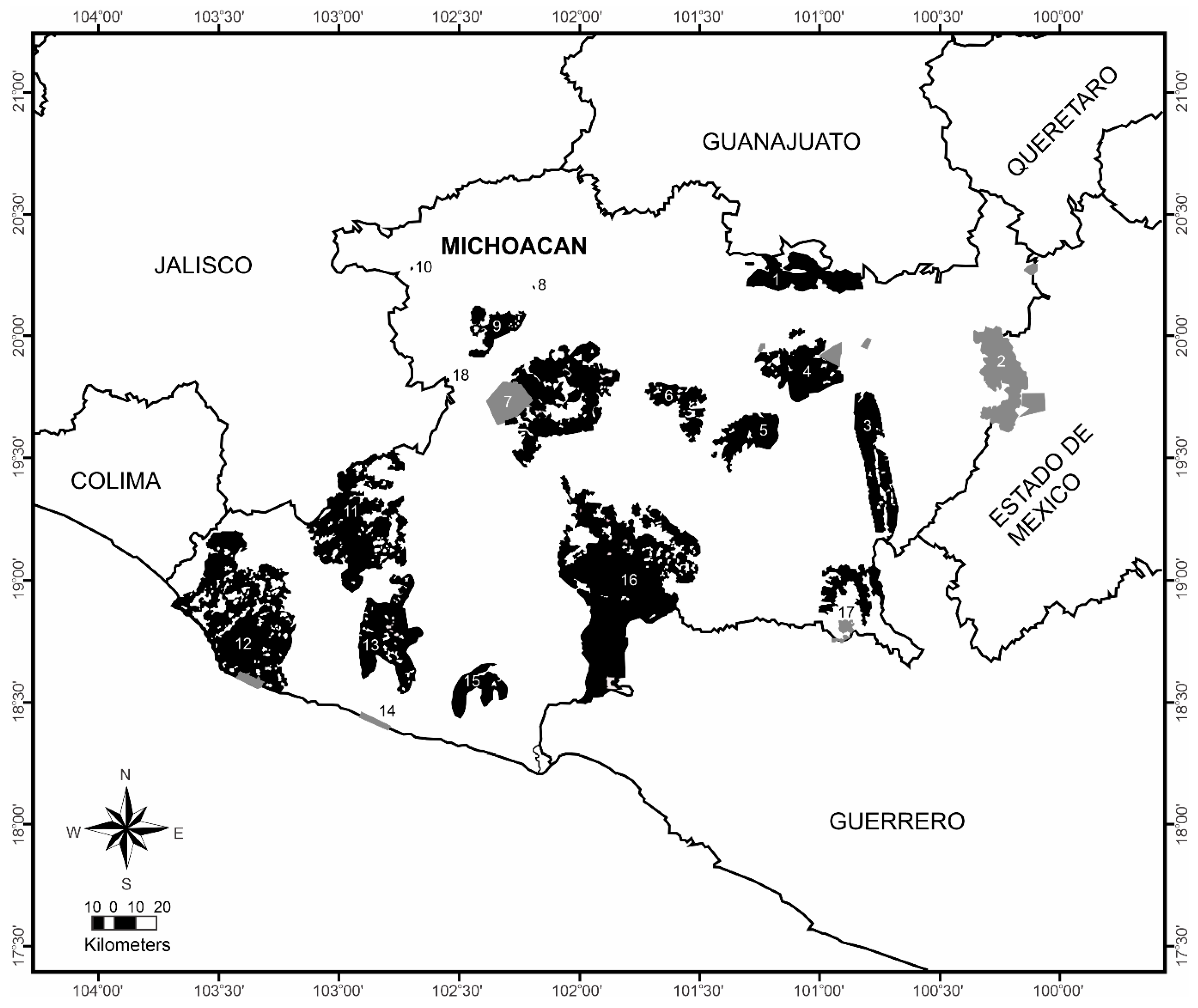
| Michoacan | Established protected areas by 2014 | ||||
|---|---|---|---|---|---|
| Number on map | Areas | Surface (Km2) | % | Surface (Km2) | % |
| 1 | Cuitzeo-Copandaro | 421.52 | 0.71 | 2.54 | 0.02 |
| 2 | Monarch Butterfly Biosphere Reserve | 562.79 | 0.95 | 562.79 | 5.37 |
| 3 | Tiquicheo-Tzitzio-Madero | 546.14 | 0.93 | 0.00 | 0.00 |
| 4 | Morelia-Tzitzio | 540.64 | 0.92 | 66.59 | 0.64 |
| 5 | Madero-Tacambaro | 317.19 | 0.54 | 0.77 | 0.01 |
| 6 | Opopeo | 244.18 | 0.41 | 0.00 | 0.00 |
| 7 | Pico de Tancítaro | 1,193.98 | 2.02 | 222.22 | 2.12 |
| 8 | Parque Nacional Lago de Camecuaro | 0.11 | 0.00 | 0.11 | 0.00 |
| 9 | Los Reyes | 206.49 | 0.35 | 0.00 | 0.00 |
| 10 | Parque Juárez de Jiquilpa | 0.08 | 0.00 | 0.08 | 0.00 |
| 11 | Coalcoman | 1,110.34 | 1.88 | 0.00 | 0.00 |
| 12 | Chinicuila-Coahuayana | 1,615.54 | 2.74 | 33.94 | 0.32 |
| 13 | Aguililla-Coalcoman-Tumbiscatio | 649.26 | 1.10 | 0.00 | 0.00 |
| 14 | Playa Mexiquillo | 31.35 | 0.05 | 31.35 | 0.00 |
| 15 | Arteaga | 241.73 | 0.41 | 0.00 | 0.00 |
| 16 | La Huacana-Churumuco-Artega | 2,418.77 | 4.10 | 0.00 | 0.00 |
| 17 | Huetamo-Turitzio | 298.40 | 0.51 | 0.00 | 0.00 |
| 18 | Chorros del Varal (Los Reyes) | 0.73 | 0.00 | 0.73 | 0.01 |
| Total | 10,399.24 | 17.63 | 921.13 | 8.79 | |
Disclaimer/Publisher’s Note: The statements, opinions and data contained in all publications are solely those of the individual author(s) and contributor(s) and not of MDPI and/or the editor(s). MDPI and/or the editor(s) disclaim responsibility for any injury to people or property resulting from any ideas, methods, instructions or products referred to in the content. |
© 2023 by the authors. Licensee MDPI, Basel, Switzerland. This article is an open access article distributed under the terms and conditions of the Creative Commons Attribution (CC BY) license (http://creativecommons.org/licenses/by/4.0/).


