Preprint
Article

Homogenous Climatic Regions for Targeting Green Water Management Technologies in the Abbay Basin, Ethiopia

Altmetrics

Downloads

110

Views

40

Comments

0

A peer-reviewed article of this preprint also exists.

Submitted:

08 September 2023

Posted:

11 September 2023

You are already at the latest version

Alerts
Abstract
Spatiotemporal climate variability is a leading environmental constraint to the rain-fed agricultural productivity and food security of communities in the Abbay basin and elsewhere in Ethiopia. The previous one-size-fits-all approach to soil and water management technology targeting did not effectively address climate-induced risks to rain-fed agriculture. This study, therefore, delineates homogenous climatic regions and identifies climate-induced risks to rain-fed agriculture that are important to guide decisions and selection of site-specific technologies for green water management in the Abbay basin. The k-means spatial clustering method was employed to identify homogenous climatic regions in the study area, while the Elbow method was used to determine an optimum number of the climate clusters. The k-mean clustering used the Enhancing National Climate Services (ENACTS) daily rainfall, minimum and maximum temperatures, and other derived climate variables that include daily rainfall amount, length of growing period (LGP), rainfall onset and cessation dates, and rainfall intensity, temperature, potential evapotranspiration (PET), soil moisture and AsterDEM to define climate regions. Accordingly, 12 climate clusters or regions were identified and mapped for the basin. Clustering a given geographic region into homogenous climate classes is useful to accurately identify and target locally relevant green water management technologies to effectively address local-scale climate-induced risks. The study has also provides a methodological framework that can be used in the other river basins of Ethiopia and indeed elsewhere.
Keywords: 
Subject: Environmental and Earth Sciences  -   Atmospheric Science and Meteorology

1. Introduction

Spatiotemporal climate variability is a leading environmental factor that determines the rain-fed agricultural productivity and food security of communities in a given geographical region by affecting the amount and spatiotemporal distribution of green water resources; the water held in the soil and available to crops and plants [1,2]. Temperature and rainfall variability cause 30–50% inter-annual variability in cereal crop productivity in rain-fed agriculture [3]. The impact of climate variability is extremely high in countries like Ethiopia, where there is very high spatiotemporal rainfall and temperature variability, caused by the complex topography and north-south oscillation of overhead solar radiation [4]. The impact of climate on rain-fed agriculture is not only caused by inter-annual rainfall variability but also by fluctuations in annual rainfall cycles, length of growing period (LGP), rainfall intensity, rainfall onset and cessation dates, and outbreak of climate-related crop diseases and pests [5,6,7]. Temperature also determines the spatial and temporal distribution of green water and crop productivity in the rain-feed agriculture system by influencing the rate of water loss from the soil through evapotranspiration [7,8].
Evidence from empirical studies such as [4] indicates that the occurrence and impact of climate-induced risks on rain-fed agriculture differ from region to region significantly. Furthermore, except for temperature, which showed a steadily increasing trend over large areas, trends in rainfall amount and extremes are complex and varied from place to place in the Abbay basin in particular and across Ethiopia in general [4,9]. Similarly, scenario-based studies indicate that impacts of future climate change on rain-fed agriculture and crop productivity vary from place to place in Ethiopia [10,11]. In addition to the climatic factors, there are other environmental factors such as topography, soil condition, land use and cover as well as anthropogenic factors such as agricultural practices and management decisions can affect availability of green water in a given area and at a particular time [12]. Recent evidence also confirms that climate change, population growth, and land cover conversation are significantly affecting availability and distribution of green water resources [13,14,15].
Poor water utilization and management practices are another set of drivers for the low productivity of primary small holder rain-fed agricultural in the county [16]. Although many soil and water conservation programs and projects have been implemented since the 1980s, the outcomes have not been adequate nor sustainable as both design and implementations followed top-down and one-size-fits-all approaches without considering spatial climatic variations [16,17]. Moreover, the traditional agroecological zone (AEZ)-based recommendations for green water and agronomic management practices [18] poorly capture local-scale climate-driven green water related risks. Hence, there is the need to improve green water management practices and the targeting of green water management interventions in the country by considering local scale patterns and risks of climate variability and climate change. Clustering areas into homogenous climatic units can facilitate the identification and characterization of major agricultural water security risks, as well as foster the selection and implementation of site-specific green water management technologies [16].
BCEOM [19] is the only available study that has classified the Abbay basin into four climate clusters by considering the spatial variation of rainfall amount and its seasonal distribution. The four climate clusters include: 1) the southeastern part of the basin which receives more than 1400 mm mean annual rainfall and has a relatively longer monomodal rainfall pattern, 2) the central part of the basin which is characterized by short-length monomodal rainfall pattern, 3) the eastern part of the basin that has small and bimodal rainfall pattern, and 4) the northwestern part of the basin that has monomodal rainfall pattern and receives less than 1200 mm mean annual rainfall amount. Another national scale study conducted by [20] classified the Abbay basin into 5 rainfall clusters based on seasonal rainfall cycles and interannual rainfall variability. These rainfall-based clustering studies have identified the broader regional classes, but have not captured local scale rainfall variability and water availability, and hence are not suitable for local scale planning and operational activities. There is a need for a higher resolution classification that uses multiple climate and non-climate (e.g., topography) variables to support effective green water management.
The objective of this study is to produce and characterize climate clusters for the Abbay basin. The clustering was made for the kiremt (June – September) primary rainy season, which supports 70-80% of the rain-fed agricultural production of the country. Different from previous studies such as [19,21,22,23,24] that considered only the spatial variation of the annual rainfall cycle, we used other rainfall variables (rainfall amount, onset and cessation dates, length of growing period and rainfall intensity), temperature, evapotranspiration and soil moisture in our climate classification. These climate variables are important determinants of productivity of the rain-fed agricultural system of the country. For example, rainfall and temperature variability and extreme events such as floods, soil erosion, under normal rainfall (droughts) during the growing period, heat and cold waves caused by extreme high and low temperatures respectively, and heavy rains can affect crop production [25]. Rain-fed based crop production is challenged due to acidic soil in areas that experience elongated heavy rainfall amount in Ethiopia [26,27]. Traditional agricultural practice and crop productivity in areas covered by vertisols and receive high rainfall amount affected by waterlogging problem [28]. Rainfall onset and cessation times largely determine the length of growing period (LGP) in one area. On the other hand, high temperatures can affects crop productivity by determining the physiological, morphological, and biochemical changes in crops. It is also responsible to cause heat stress on plants [29]. Over highland part of Ethiopia, the occurrence of low temperature during the growing period determines plant germination and vegetative growth seed development. Temperature also determines crop yield by determining soil moisture availability by determining the amount and rate of potential evapotranspiration [25]. The results generated from this study are useful to optimize the selection and application of site-specific green water management technologies in the study area.

2. Data and Methods

2.1. Study area

The Abbay basin, also called the Upper Blue Nile Basin (UBNB), is located in the north-western part of Ethiopia between 70 40’ N and 120 51’ N, and 340 25’ E and 390 49’ E, and covers a total area of 199,812 km2 (Figure 1). Rugged topography in the central and eastern parts and flat lowlands in the western parts is the major terrain feature of the basin. About 60% of the basin’s area is highland with elevations of ≥1500 m asl. It is an important basin in the country as it contributes approximately 45% of the total surface water resources, accommodates 25% of the population, accounts for 20% of the area, and contributes about 40% of the agricultural production in the country [30]. The mean annual runoff generated from the Abbay basin is estimated at 49 BCM. The rugged topography together with the north-south oscillation of the Inter Tropical Convergence Zone (ITCZ) controls the geographical and temporal distribution of the climate system in the Abbay basin [31]. The climate in Abbay basin varies between hot and semi-arid conditions in the lowlands along the Ethio-Sudanese boarder and cool and humid conditions in the highlands located in the eastern part of the basin [32].

2.2. Data and the sources

For this study, different climatic data were used for processing and development of homogeneous climate clusters (Table 1). The daily time scale 4 km resolution Enhancing National Climate Services (ENACT) rainfall, minimum and maximum temperature datasets [33] were used. These datasets were also used to derive the onset date, cessation date and length of growing period (LGP) which were used as inputs in the analysis. Climate variability controls the practice and productivity in the rain-feed agricultural system by determining the start and end of the farming calendar, LGP, soil moisture balance, and types of crops that can be grown in an area [5,6].
The LGP was defined as the number of days when the precipitation amount exceeded half of the potential evapotranspiration. The rainfall onset and cessation dates were also determined by considering this water balance approach. Rainfall onset and cessation dates for the growing period were defined when the precipitation amount exceed and drop half of the PET amount at daily time scale, respectively. It is important to mention here that the indicated cessation dates do not mean that there is no rainfall after those dates; rather the cessation dates refer to the dates when the amount of rainfall becomes less than half of the PET. Potential evapotranspiration and soil moisture datasets were estimated using a simple bucket 1D water balance model at the daily timescale, and were used as inputs. In this method, soil moisture was generated at the daily time-scale by assuming the soil as a reservoir that periodically to be filled by rainfall events in the form of randomly distributed patterns [34]. This water balance mode used to estimate soil moisture dynamics in a single top soil layer and conceptualized as a bucket receiving and filled by infiltration driven by the gravity and lost by evapotranspiration and/or drainage [35]. Precipitation concentration index was generated from the precipitation data and used to capture the temporal distribution of rainfall and its spatial pattern. It is used to quantify the relative distribution of the rainfall patterns. According to Oliver [36], a PCI value < 10.0 represents mostly uniform precipitation distribution. A PCI between 11 and 15 represents moderate precipitation concentration. A PCI between 16 and 20 represents irregular distribution. A PCI value above 20 represents strong irregularity.
Topography is another dimension that was considered in the study since it is an important local climate modifier as well as determines surface moisture conditions. Overall, 10 variables input layers were prepared for the clustering analysis (Table 1).

2.3. Data Processing

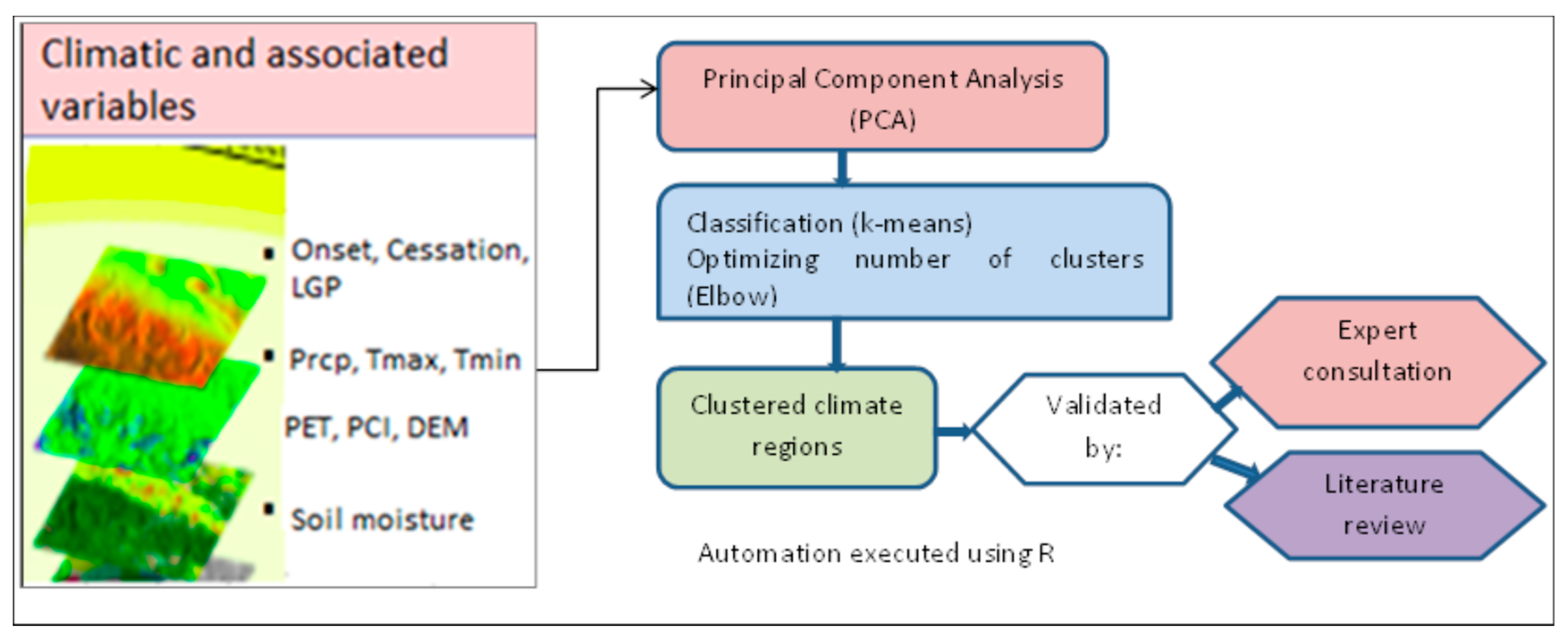
A stepwise data processing technique was employed for the study (Figure 2). The first step was making all data layers have the same boundary and spatial resolution; the data layers were clipped to the Abbay basin boundary and resampled to a 4 km grid resolution. The second step involved the calculation of exceedance probabilities to capture the temporal variability of the climate variables. Typically, an 80% exceedance probability is used in long-term climate analysis, and this reference was used here. Subsequent to the exceedance probabilities computation, variable selection was carried out to reduce the variable space and allow parsimonious model-based clustering. For this, principal component analysis (PCA) was used to reduce the data dimension and maintain only important variables by excluding those which carry redundant information. PCA axes with eigenvalues greater than 1 were retained to ensure that only PCA axes with a significant contribution are used for further analysis [37]. However, we retained a climate variables (cessation date) due to its importance in determining the timing and availability of green water resource in the rain-fed-based agricultural system. The final data processing step was clustering and in this study the K-means spatial clustering [38,39,40,41] was employed to find homogenous climatic regions of the study area. K-means is generally simple to implement and it can be used with large datasets having medium to coarse spatial resolution.
The K-means algorithm requires the user to specify the number of clusters. To reduce subjectivity, the elbow method was used to select the optimal number of clusters. This method calculates the Within-Cluster Sum of Squares (WCSS), which is the sum of the squared distance between each point and the centroid in a cluster. The elbow method uses a graphical representation to select the optimal K.
The 1st moment and 2nd moment descriptive statistics were applied to characterize each homogeneous climate cluster and interpret with respect to water availability and agricultural water management. In this regard, mean, median, range, standard deviation and variance statistics were used. The climate classification was performed for the Kiremt growing season. The length of the growing period (LGP) was defined as the number of days taken for the cumulative precipitation to exceed half the cumulative potential evapotranspiration. The rainfall onset and cessation dates were also determined by considering this water balance approach.

3. Results

3.1. Variables used for clustering

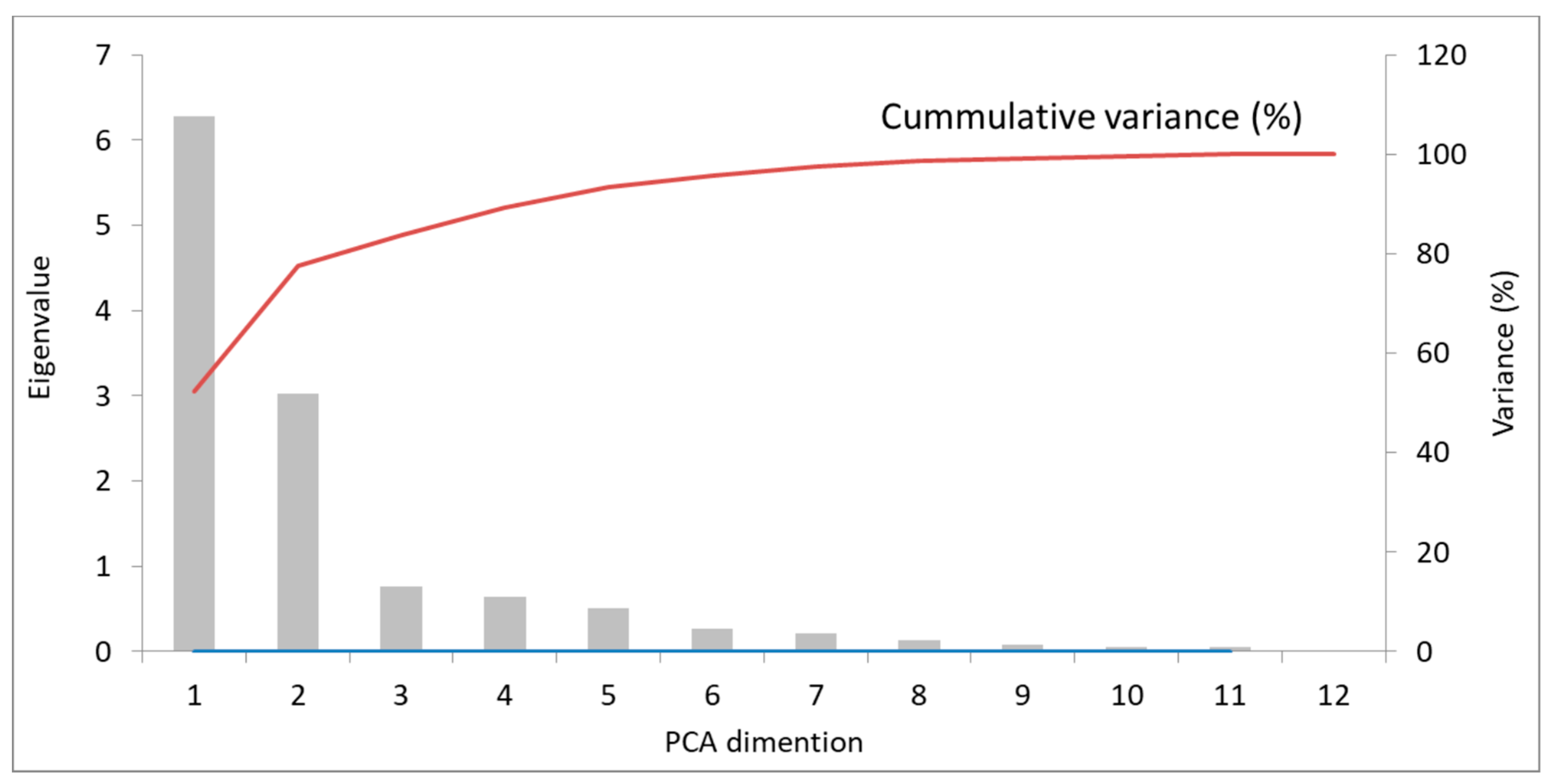
The variables used for the clustering were selected by applying PCA. Variance, cumulative variance and Eigen values generated from the PCA are shown in Figure 3. The result reveals that the two components with an Eigen value greater than one explain more than 77% of the variance. Of this, 52.3% of the variance was explained by the first component and the remaining 25.2% of the variance was explained by the second component. The Eigen values after the second dimension are less than one indicating that these PCs explain less than the original variables (Figure 3). Accordingly, only the first and second principal components were retained and selected for further analysis.
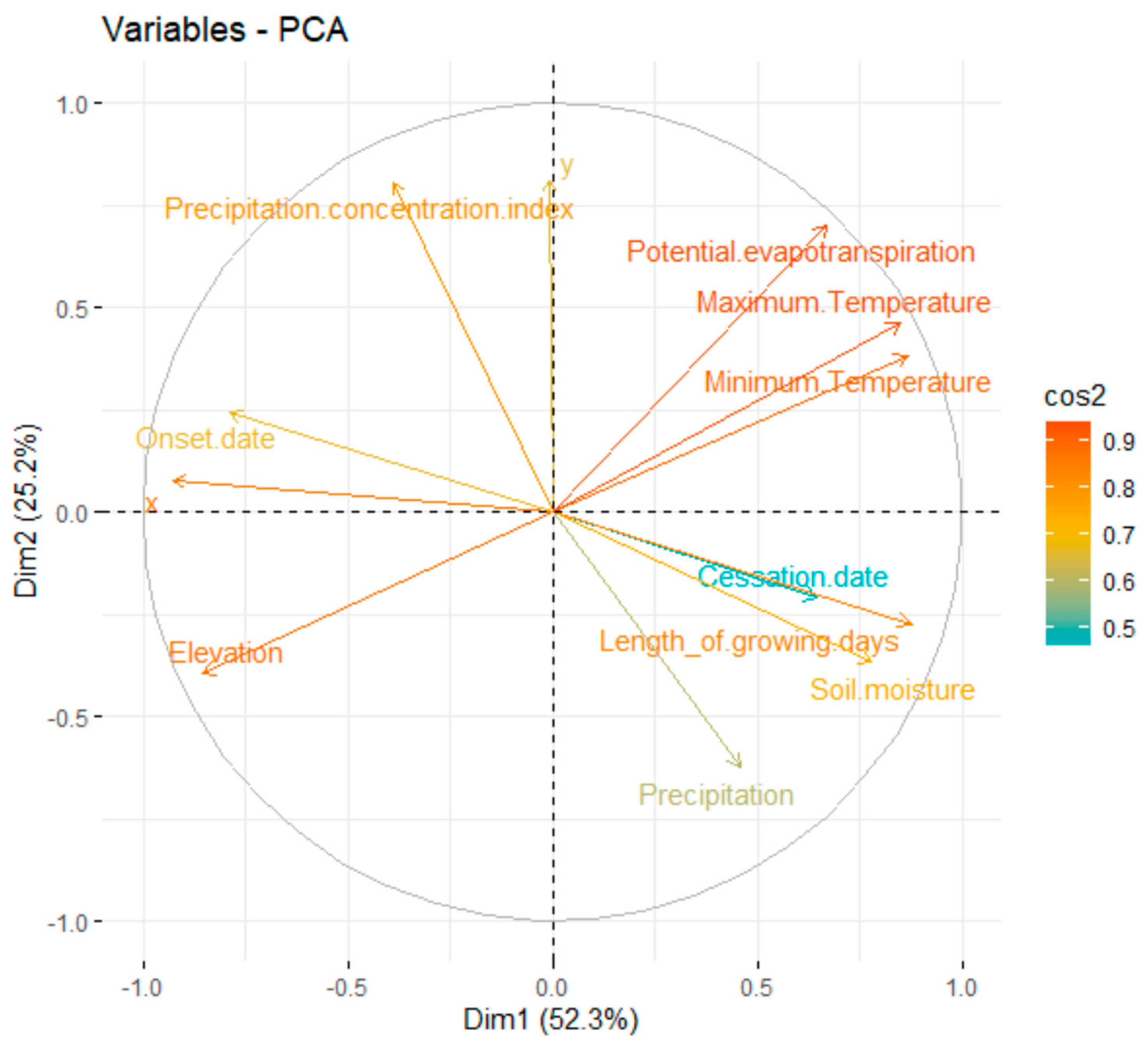
The quality of variable representation was analyzed and demonstrated on a Cos2 factor map (Figure 4). The results are presented in the Cos2 factor map, on which the variables that are better represented by the two PCs appear close to the circumference of the correlation circle. The variables are well represented by the principal components, with the exception of rainfall cessation date which has a lower representation. This latter variable was kept in the analysis, due to its importance for agriculture.
The result shown that elevation, length of growing season, rainfall onset date, maximum and minimum temperatures, soil moisture and potential evapotranspiration contribute the most to the dimension one, while precipitation concentration index, PET and precipitation contribute to the dimension two.

3.2. Climate clusters of the Abbay River Basin

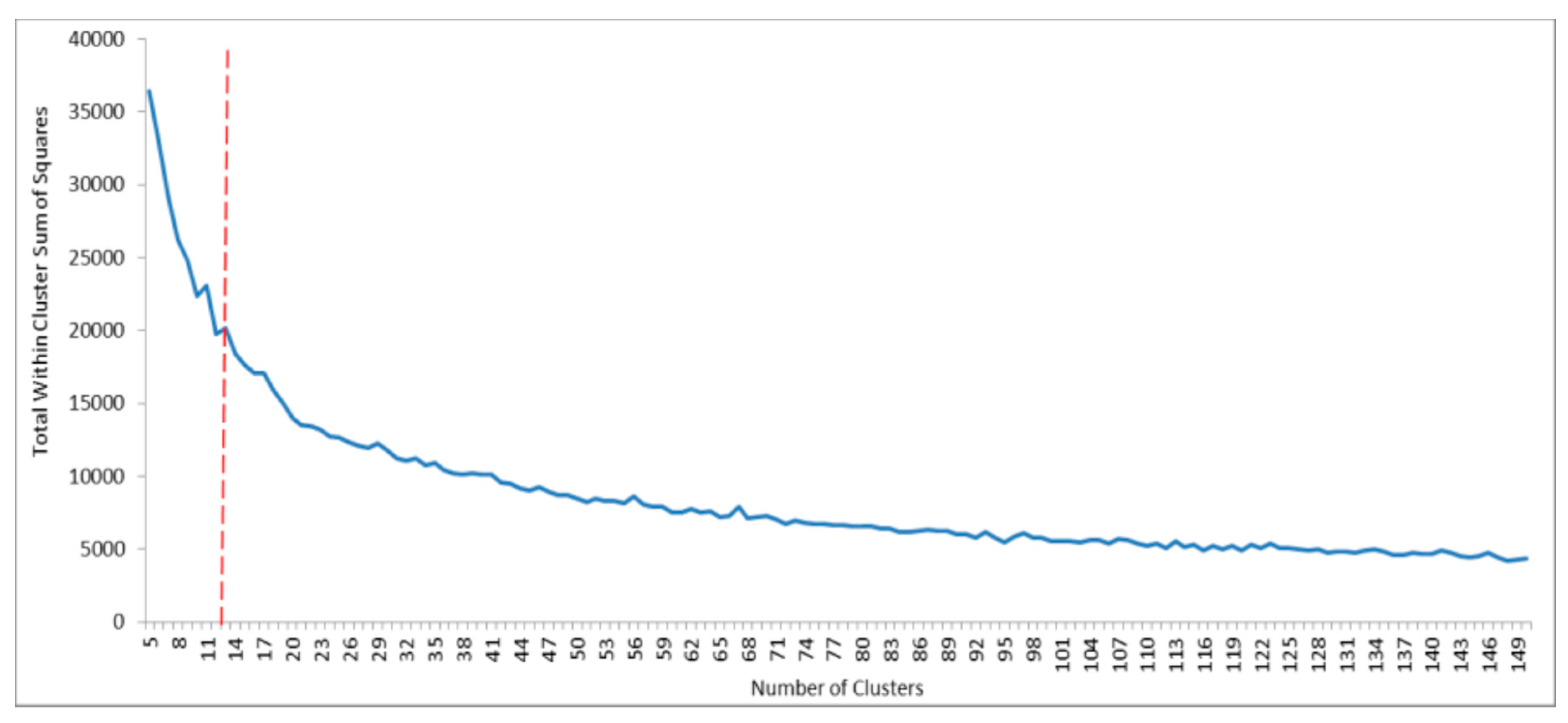
The unsupervised k-means clustering considered classifications using up to 150 clusters (Figure 5), from which the optimum number of clusters was selected using the elbow method. The Elbow method is a graphical quasi-objective method, in which the optimum number of clusters is selected at the point where the graph of number of clusters versus WCSS starts to bend and flatten-out.
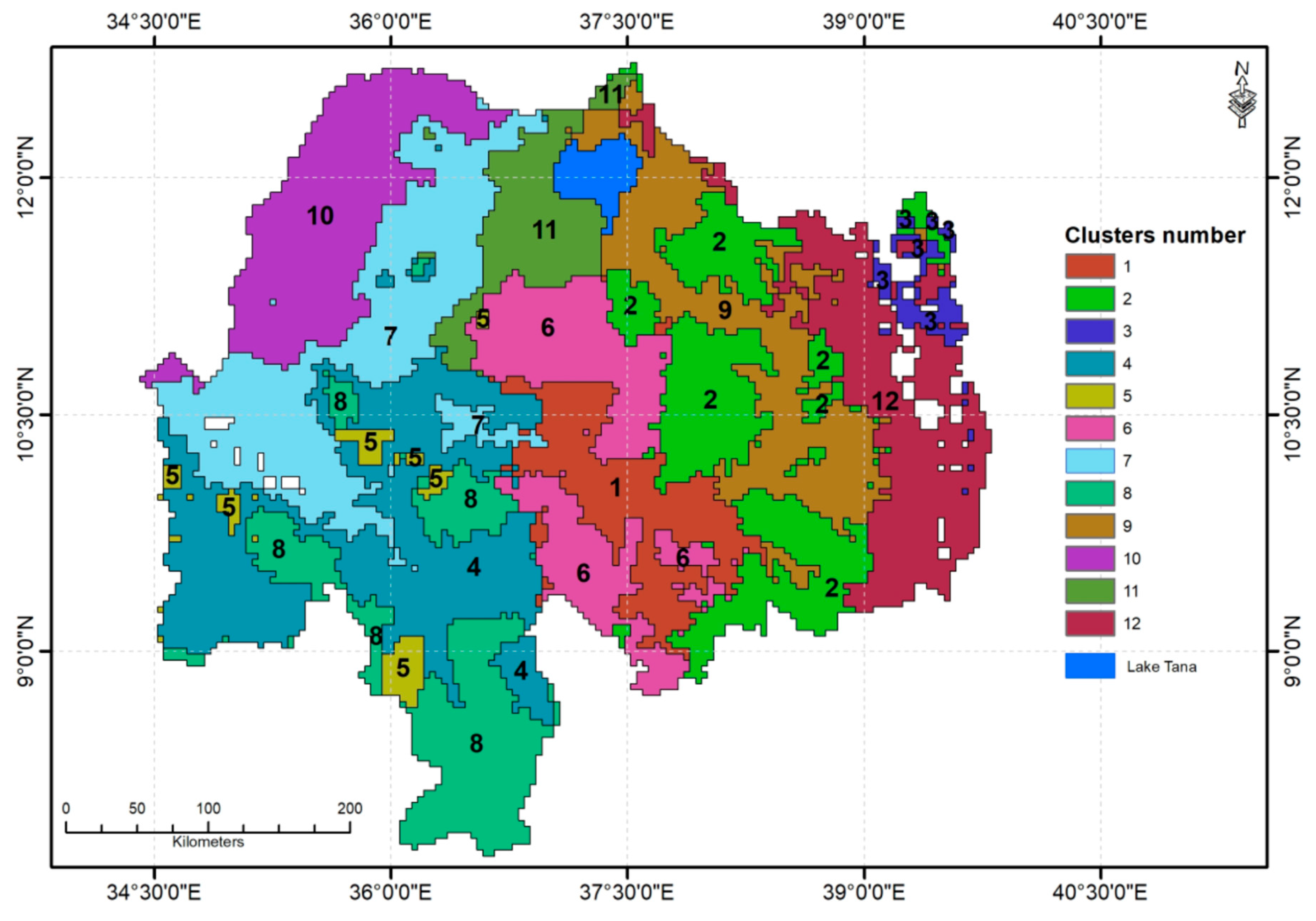
Based on the graph, 12 climate clusters were identified and mapped (Figure 6). The climate clusters are simply labelled by numbers from 1 to 12.

3.4. Climate variation between clusters

Table 2 presents the areal mean annual value of the climate variables for the 12 climate clusters of the Abbay River basin. The climate variables that were used for the study are important determinant factors of spatiotemporal variability and availability of green water for the rain-fed agriculture.
The results demonstrate that four of the climate clusters (2, 3, 9 and 12) experience a bimodal (Belg and Kiremt) rainfall pattern, and are located in the eastern part of the basin (Figure 7). The remaining eight clusters experience monomodal rainfall pattern, or the Kiremt season only. The mean length of growing period (LGP) for the Kiremt season varies between 2.5 months in climate region 12 and 5.6 months in climate region 5. The climate regions located in the western part of the basin have relatively long growing periods (4.5–5.6 months). In contrast, the LGP was relatively short (3.3–3.9 months) for those climate regions located in the central and eastern parts of the basin, except for region three, where the LGP is 5.1 months. The relatively longer LGP for region three which is located in the eastern part of the basin is attributable to the early onset of rainfall. Rainfall in this region exceeds half of the PET in early March, while this occurs in early May in the other regions of the eastern and central parts of the basin.
The rainfall onset and cessation dates were earliest for region 3; in this region rainfall exceeds half of the PET in early April and drops to half of PET in early September. Region 12 has a similar rainfall cessation date (early September). The rainfall onset time in five regions (4, 5, 7, 8 and 10) is in the first two weeks of May. The rainfall onset for the other six regions is between early May (regions 6 and 11) and third week of May (Regions 2, 9 and 12). The rainfall cessation date for four climate regions (1, 2, 6, and 9) is in the last week of September, while it is in early October in five regions (4, 7, 8, 10 and 11). The fall of rainfall amount to less than half of the PET can be caused by the decrease in rainfall amount or increase in the PET amount as the temperature starts to rise with the decreasing cloud cover over the region. The rainfall cessation time for region 5 is in October.
In general, the mean annual rainfall decreases from southwestern towards northern and northeastern parts of the basin. The mean annual rainfall is relatively small (less than 1200 mm) for climate regions 2, 3, 9 and 12, which are all located in the eastern and central parts of the basin. The mean annual rainfall is relatively high (1514.2–1769.5 mm) in four climate regions (4, 5, 6, and 8) which are located in the southwestern part of the basin. The mean annual rainfall in regions 7, 10 and 11, which are located in the northwestern part of the basin, is 1423.5 mm, 1198.9 mm and 1427.5 mm, respectively. Furthermore, mean annual rainfall for region 1 is 1386.4 mm
The intensity of rainfall as represented by PCI is lowest (14.6 mm) in region 8 and highest (21.1 mm) in region 12. The PCI is relatively low (14.6 – 16.6) for regions 1, 4, 5, 6 and 8, and all of these regions are located in the southwestern part of the basin. These climate clusters are also known for their extended rainfall season. The PCI is high (19.9 – 21.1) in regions 3, 9, and 12; all of these regions are located in the extreme eastern part of the basin. The mean annual PET amount is lowest (1261.2 mm) in region 2 and highest (1846.8 mm) in region 10. In general, the mean annual PET is high in climate regions 7 (1655.8 mm) and 10 (1846.8 mm); both of these regions are located in the western lowland part of the basin. It is relatively low (1261.2 mm – 1301.3 mm) in regions 2, 3, 6, 8, and 12. The mean annual PET in the five regions (1, 4, 5, 9 and 11) varies between 1409.8 mm and 1467.0 mm. The spatial variation of annual PET is due to the variation of temperature between the climate clusters. The mean annual minimum and maximum temperatures vary between 8.9 0C and 19.1 0C, and 22.0 0C and 34.8 0C, respectively. The mean minimum and maximum temperatures are high in the two climate regions (7 and 10) that are located in the western part of the basin. The mean minimum and maximum temperatures are 16.4 0C and 31.2 0C in region 7 and 19.1 0C and 34.8 0C in region 10, respectively. Low mean minimum (8.9 – 9.2 0C) and maximum (22.0 - 23.1 0C) temperatures characterize the three climate regions which are located in the eastern part of the basin.
Soil moisture content also reveals significant variation between the climate clusters. The lowest (10.6 mm) mean annual soil moisture content is found for climate region 9 and the highest (79.9 mm) mean annual soil moisture content is found for climate region 8. In general, mean annual soil moisture content is relatively high (60.1 – 79.9 mm) in four climate regions (4, 5, 7, and 8). In contrast, four climate regions that include regions 2, 3, 9 and 12 have relatively low (10.6 – 13.8 mm) mean soil moisture content; all of these regions are located in the eastern part of the Abbay basin. The mean annual soil moisture content for the other climate regions varies between 24.7 mm in region 1 and 58.3 mm in region 11.
The mean altitude of climate regions varied between 698 m asl for climate region 10 and 2620.3 m asl for climate regions 3 (Table 2). As shown in Table 2, the mean altitude for climate regions 7 and 10 are relatively low, 974.8 m asl and 698 m asl, respectively. Both of these climate regions are located in the northwestern part of the basin. In contrast, climate regions 2, 3, 6 and 12 which are located in the eastern part of the basin have relatively high that ranges from 2267.2 m asl and 2620.3 m asl. The results further showed the absence of systematic relationship between rainfall variables and altitude in the Abbay basin. In contrast the distribution of PET, temperature and soil moisture displayed systematic relationship with altitude. In this regard, temperature and PET are relatively higher in lowland climate regions (7 and 10) and low in highland climate regions (e.g., 2, 3, 9 and 12). On the other hand, the mean annual soil moisture amount is relatively high in the lowland climate regions (7 and 10) and relatively low in highland climate regions (e.g., 2, 3, 9 and 12).
In general, regions 2, 3, 9 and 12 have 2 rain cycles, – what distinguishes the clusters is PCI and onset date [the other variables have relatively similar values]. Of the others, climate region 5 is distinct as it has relatively longer LGP, which is attributed to the late cessation date. On the other hand, climate region 10 followed by climate region 7 has high PET. Furthermore, climate region 1 and 6 are very similar in all climate characteristics, except climate region 6 is slightly wetter.

4. Implications for targeting green water management technologies

This study has produced data-driven homogenous climate clusters that are useful to identify local scale climate-induced risks for the rain-fed agriculture system and to facilitate selection of site-specific green water management technologies in the Abbay River basin. The assumption is that spatiotemporal climate variability is the leading environmental determinant factor to productivity of the rain-fed agriculture in the basin. Climate variability controls the practice and productivity in the rain-feed agricultural system by determining the start and end of the farming calendar, LGP, soil moisture balance, and types of crops that can be grown in an area. It also relates to many risks to the rain-fed agriculture, such as shortage of water associated with seasonality of the rainfall or due to excessive evapotranspiration or both, the occurrence of flood and soil erosion due to a high amount or intensity of rainfall or both, water logging and soil acidity caused by the seasonal high-intensity rainfall, and soil salinity caused by high rates of evapotranspiration. These risks can significantly constrain rain-fed agricultural practices and crop productivity [2,5,7,9,41]. It is important to note that the prevalence, severity, and effects of these climate variability-induced agricultural challenges vary spatially across the Abbay basin [16]. Previous soil and water conservation practices as well as other agronomic interventions did not achieve the intended outcomes as they followed a one-size-fits-all top-down approach without considering regional and local-scale climate variability [17,32].
The results generated from this study have contributed to identifying appropriate green water management technologies to address climate-induced risks to the rain-fed agricultural system. For example, all climate regions located in the eastern part of the basin, except climate region three have relatively short LGP (2.5 – 3.9 months), which means longer dry periods. This suggests that agricultural productivity in these regions is constrained by the short LGP. Some of the climate regions (2, 9, and 12) experience a bimodal (Kiremt and Belg) rainfall pattern, the rainfall amount during the later season is too erratic, unreliable and exceeded by PET. In these regions, rainwater harvesting and supplementary irrigation can be used to complement the short LGP and improve agricultural productivity.
Climate regions 2, 9, 11, and 12 have relatively high PCI (18.1–21.1), which means there is high rainfall seasonality that can generate excessive surface runoff during the Kiremt season. Rainwater harvesting such as small-scale water reservoirs and well-designed private ponds will be a useful strategy to extend the period of water availability in these regions. Using water-efficient technologies and agronomic practices are also appropriate interventions in these regions. It is important to note that most of these areas have dense populations, which means a large number of the workforce remains idle for an extended period (6.5 – 7.5 months) of the year. Rainwater harvesting and dry season production activities are therefore important from the perspective of improved use of the labour resource.
Many empirical studies confirm the significant contribution of small-scale irrigation to poverty reduction [43,44,45,46,47] and improved food security [48,49,50] in the rural areas of Ethiopia. Furthermore, the construction of rainwater harvesting schemes in regions that experience short LGP and high PCI can reduce the frequency and intensity of flood events during the peak rainfall season and increase groundwater storage and low flows. The presence of a water harvesting scheme at an upper part of the river basin can significantly regulate soil erosion and reduce sediment yields [51].
Soil management practices emerge as priority interventions in the climate regions 2, 3, 9, 11, and 12 where the PCI is high. This is because high rainfall concentration results in low infiltration and high surface runoff, cause severe soil erosion [16]. Soil acidity management should be a top priority green water management strategy in the climate regions 4, 5, 6, and 8, where annual rainfall amount is in excess of 1500 mm.
For the climate regions 2, 3, 9, and 12 (all located in the eastern part of the basin) where soil moisture contents are low (10.6 – 13.8 mm), soil water conservation technologies will be important interventions. Although these climate regions have bimodal rainfall cycles (Kiremt and Belg), the Kiremt rainfall has a short duration (2.5 – 3.3 months), except for region 3 where the LGP is 5.1 months, and the Belg season’s rainfall is decreasing and highly unreliable for agricultural production. A recent study by Tibebe [16] indicated that agricultural productivity in the Abbay basin is negatively affected not only by the high level of climate variability but also by the low and poor utilization and management of the available water. Hence, it is important to enhance or introduce water utilization technologies to efficiently use the available moisture that occurs during the two rainy seasons. There are very large areas in Region 12, particularly in Semien Shewa and Debub Wollo, where farmers cannot cultivate crops during Kiremt season due to water logging [52]. This problem is observed in the highland areas, where barley is the dominant type of crop. The water logging problem is not only caused by the occurrence of excessive rainfall but also due to the nature of the soil. Therefore, water logging management should be a top priority green water management issue in these areas.
Opportunities extend the crop season using available moisture in those climate regions that have relatively long LGP (3, 4, 5, 7, 8, and 10). The LGP in these climate regions varies between 4.5 and 5.6 months, and all except region 3 are located in the western part of the basin. It is important to target short-maturing crop varieties and other agronomic and agro-climate services to enable crop production for more than a single season.
The climate regions 2 and 9 experience short LGP, heavy rainfall during kiremt season, soil erosion and shortage of soil moisture in the dryland areas. Hence, the impact of such multiple risks on the rain-fed agriculture should be addressed by carefully understanding their co-occurrences and synergies and through targeted package-based interventions. For example, structural measures used to protect soil erosion in the moisture stressed highland areas can be designed in a way to enhance on-farm soil moisture and groundwater recharge by reducing the velocity of surface runoff.

5. Conclusion

Clustering of a given geographic region into homogenous climate units is important to identify site-specific climate related water security risks, and to facilitate selection and implementation of appropriate green water management technologies for improved productivity of rain-fed agricultural systems. This study has undertaken a climate classification scheme for the Abbay basin, where rain-fed agriculture is highly constrained by spatiotemporal climate variability. The k-means unsupervised clustering approach was employed to define homogeneous climate clusters by using climate variables (daily rainfall amount, rainfall intensity, rainfall onset and cessation dates, LGP, PCI, PET, and soil moisture) that have determinant impacts on rain-fed agriculture.
The climate classification scheme has generated 12 homogenous climate clusters for the basin. The results are discussed with reference to climatic characteristics, potential climate-related risks to the rain-fed agriculture, and green water management options across the identified climate clusters. The climate classification approach and results presented in this study have multiple implications for a transformative green water management by facilitating the selection and targeted implementation of technologies tailored to local circumstances. The overall outcome will be efficient utilization of the scarce water and land resources, and improved agricultural production and food security in the area. Furthermore, the study provides a methodological framework that can be used in the other river basins of Ethiopia and indeed elsewhere.

Author Contributions

Conceptualization, Degefie Tibebe and Woldeamlak Bewket; methodology and data analysis, Degefie Tibebe; formal analysis, Mekonnen Adnew Degefu; writing—original draft preparation, Mekonnen Adnew Degefu; Supervision, Woldeamlak Bewket; writing—review and editing, Woldeamlak Bewket, Ermias Teferi, Greg O’Donnell and Claire Walsh. All authors have read and agreed to the published version of the manuscript.

Acknowledgments

This research work was financially supported by Water and Land Resource Center (WLRC), Addis Ababa University (AAU) funded by the UKRI GCRF (Grant Number: ES/S008179/1) Water Security and Sustainable Development Hub Project. We also thank the Ethiopian Meteorological Institute (EMI) for providing climate data for the study.

Conflicts of Interest

The authors declare no conflict of interest.

References

  1. Brown, C.; Hansen, J.W. Agricultural Water Management and Climate Risk. In Report to the Bill and Melinda Gates Foundation; IRI Tech. Rep. No. 08-01; International Research Institute for Climate and Society: Palisades, New York, USA, 2008; pp. 19p. [Google Scholar]
  2. Kotir, J.S. Climate change and variability in Sub-Saharan Africa: a review of current and future trends and impacts on agriculture and food security. Environ. Dev. Sustain. 2010, 13, 587–605. [Google Scholar] [CrossRef]
  3. Holleman, C.; Rembold, F.; Crespo, O.; Conti, V. The impact of climate variability and extremes on agriculture and food security – An analysis of the evidence and case studies. In Background paper for The State of Food Security and Nutrition in the World 2018; FAO Agricultural Development Economics Technical Study No. 4; FAO: Rome, 2020. [Google Scholar] [CrossRef]
  4. Conway, D.; Schipper, E.L.F. Adaptation to climate change in Africa: Challenges and opportunities identified from Ethiopia. Glob. Environ. Change 2011, 21, 227–237. [Google Scholar] [CrossRef]
  5. Ademe, F.; Kibret, K.; Beyene, S.; Getinet, M.; Mitike, G. Rainfall analysis for rain-fed farming in the Great Rift Valley Basins of Ethiopia. J. Water Clim. Change 2020, 11, 812–828. [Google Scholar] [CrossRef]
  6. Ademe, D.; Zaitchik, B.F.; Tesfaye, K.; Simane, B.; Alemayehu, G.; Adgo, E. Analysis of agriculturally relevant rainfall characteristics in a tropical highland region: An agroecosystem perspective. Agric. For. Meteorol. 2021, 311, 108697. [Google Scholar] [CrossRef]
  7. Mubenga-Tshitaka, J.; Dikgang, J.; Mwamba, J.W.M.; Gelo, D. Climate variability impacts on agricultural output in East Africa. Cogent Econ. Finance 2023, 11, 2181281. [Google Scholar] [CrossRef]
  8. Ochieng, J.; Kirimi, L.; Mathenge, M. Effects of climate variability and change on agricultural production: The case of small scale farmers in Kenya. NJAS - Wagening. J. Life Sci. 2016, 77, 71–78. [Google Scholar] [CrossRef]
  9. Bewket, W. Climate change perceptions and adaptive responses of smallholder farmers in central highlands of Ethiopia. Int. J. Environ. Stud. 2012, 69, 507–523. [Google Scholar] [CrossRef]
  10. Evangelista, P.; Young, N.; Burnett, J. How will climate change spatially affect agriculture production in Ethiopia? Case studies of important cereal crops. Clim. Change 2013, 119, 855–873. [Google Scholar] [CrossRef]
  11. Ginbo, T. Heterogeneous impacts of climate change on crop yields across altitudes in Ethiopia. Clim. Change 2022, 170, 1–12. [Google Scholar] [CrossRef]
  12. Tamene, L.; Abera, W.; Bendito, E.; Erkossa, T.; Tariku, M.; Sewnet, H.; Tibebe, D.; Sied, J.; Feyisa, G.; Wondie, M.; Tesfaye, K. Data-driven similar response units for agricultural technology targeting: An example from Ethiopia. Exp. Agric. 2022, 58, 1–17. [Google Scholar] [CrossRef]
  13. Zang, C.; Liu, J.; van der Velde, M.; Kraxner, F. Assessment of spatial and temporal patterns of green and blue water flows under natural conditions in inland river basins in Northwest China. Hydrol. Earth Syst. Sci. 2012, 16, 2859–2870. [Google Scholar] [CrossRef]
  14. Zhang, Y.; Tang, C.; Ye, A.; Zheng, T.; Nie, X.; Tu, A.; Zhu, H.; Zhang, S. Impacts of climate and land-use change on blue and green water: A case study of the upper Ganjiang River Basin, China. Water 2020, 12, 2661. [Google Scholar] [CrossRef]
  15. Lyu, L.; Wang, X.; Sun, C.; Ren, T.; Zheng, D.-F. Quantifying the Effect of Land Use Change and Climate Variability on Green Water Resources in the Xihe River Basin, Northeast China. Sustainability 2019, 11, 338. [Google Scholar] [CrossRef]
  16. Tibebe, D.; Teferi, E.; Bewket, W.; Zeleke, G. Climate induced water security risks on agriculture in the Abbay river basin: A review. Front. Water 2022, 4, 961948. [Google Scholar] [CrossRef]
  17. Zimale, F.A.; Tilahun, S.A.; Tebebu, T.Y.; Guzman, C.D.; Hoang, L.; Schneiderman, E.M.; Langendoen, E.J.; Steenhuis, T.S. Improving watershed management practices in humid regions. Hydrol. Process. 2017, 31, 3294–3301. [Google Scholar] [CrossRef]
  18. FAO. Agro-ecological Zoning. Guidelines. FAO Soils Bulletin 73, 78 pp. Soil Resources, Management and Conservation Service, FAO Land and Water Development Division; Food and Agriculture Organization of the United Nations: Rome, Italy, 1996; ISBN 92-5-103890-2. [Google Scholar]
  19. BCEOM. Abbay River Basin Integrated Development Master Plan-Phase 2 – Data Collection - Site Investigation Survey and Analysis – Volume I – Natural Resources -Geology; BCEOM: Addis Ababa, 1998; p. 144. [Google Scholar]
  20. Cheung, WH.; Senay, GB.; Singh, A. Trends and spatial distribution of annual and seasonal rainfall in Ethiopia. Int. J. Climatol. 2008, 28, 1723–1734. [Google Scholar] [CrossRef]
  21. Mengistu, D.; Bewket, W.; Lal, R. Recent spatiotemporal temperature and rainfall variability and trends over the Upper Blue Nile River Basin, Ethiopia. Int. J. Climatol. 2014, 34, 2278–2292. [Google Scholar] [CrossRef]
  22. Degefu, MA.; Rowell, D.; Bewket, W. Teleconnections between Ethiopian rainfall variability and global SSTs: Observations and methods for model evaluation. Meteorol. Atmos. Phys. 2017, 129, 173–186. [Google Scholar] [CrossRef]
  23. Degefu, MA.; Tadesse, Y.; Bewket, W. Observed changes in rainfall amount and extreme events in southeastern Ethiopia, 1955–2015. Theor. Appl. Climatol. 2021, 144, 967–983. [Google Scholar] [CrossRef]
  24. Degefu, MA.; Bewket, W.; Amha, Y. Evaluating performance of 20 global and quasi-global precipitation products in representing drought events in Ethiopia: Visual analysis. Weather Clim. Extrem. 2022, 35, 100416. [Google Scholar] [CrossRef]
  25. Abdisa, T.B.; Diga, G.M.; Tolessa, A.R. Impact of climate variability on rain-fed maize and sorghum yield among smallholder farmers. Cogent Food Agric. 2022, 8, 2057656. [Google Scholar] [CrossRef]
  26. Desta, G.; Kassawmar, T.; Tadesse, M.; Zeleke, G. Extent and distribution of surface soil acidity in the rainfed areas of Ethiopia. Land Degrad. Dev. 2021, 32, 5348–5359. [Google Scholar] [CrossRef]
  27. Abate, E.; Hussein, S.; Laing, M.; Mengistu, F. Soil acidity under multiple land-uses: assessment of perceived causes and indicators, and nutrient dynamics in small-holders’ mixed-farming system of northwest Ethiopia. Acta Agric. Scand. - B Soil Plant Sci. 2017, 67, 134–147. [Google Scholar] [CrossRef]
  28. Bedane, H.R.; Beketie, K.T.; Fantahun, E.E.; Feyisa, G.L.; Anose, F.A. The impact of rainfall variability and crop production on vertisols in the central highlands of Ethiopia. Environ. Syst. Res. 2022, 11, 1–26. [Google Scholar] [CrossRef]
  29. Hasanuzzaman, M.; Nahar, K.; Alam, M.M.; Roychowdhury, R.; Fujita, M. Physiological, biochemical, and molecular mechanisms of heat stress tolerance in plants. Int. J. Mol. Sci. 2013, 14, 9643–84. [Google Scholar] [CrossRef]
  30. Erkossa, T.; Awulachew, S.B.; Haileslassie, A.; Yilma, A.D. Impacts of improving water management of smallholder agriculture in the upper Blue Nile Basin,” in CP 19 Project Workshop Proceedings (Addis Ababa: IWMI). 2009. Available online: https://publications.iwmi.org/pdf/H042503.pdf.
  31. Fazzini, M.; Bisci, C.; Billi, P. The Climate of Ethiopia. In Landscapes and Landforms of Ethiopia, World Geomorphological Landscapes; Billi, P., Ed.; Springer Science+Business Media, 2015. [Google Scholar] [CrossRef]
  32. Tebebu, T.Y.; Bayabil, H.K.; Stoof, C.R.; Giri, S.K.; Gessess, A.A.; Tilahun, S.A.; Steenhuis, T.S. Characterization of degraded soils in the humid Ethiopian Highlands. Land Degrad. Develop. 2017, 28, 1891–1901. [Google Scholar] [CrossRef]
  33. Dinku, T.; Hailemariam, K.; Maidment, R.; Tarnavsky, E.; Connor, S. Combined use of satellite estimates and rain gauge observations to generate high-quality historical rainfall time series over Ethiopia. Int. J. Climatol. 2014, 34, 2489–2504. [Google Scholar] [CrossRef]
  34. Romano, N.; Palladino, M.; Chirico, G.B. Parameterization of a bucket model for soil-vegetation-atmosphere modeling under seasonal climatic regimes. Hydrol. Earth Syst. Sci. 2011, 15, 3877–3893. [Google Scholar] [CrossRef]
  35. Mao, W.; Yang, J.; Zhu, Y.; Ye, M.; Liu, Z.; Wu, J. An efficient soil water balance model based on hybrid numerical and statistical methods. J. Hydrol. 2018, 559, 721–735. [Google Scholar] [CrossRef]
  36. Oliver, J.E. Monthly precipitation distribution: a comparative index. Prof. Geogr. 1980, 32, 300–309. [Google Scholar] [CrossRef]
  37. Kaiser, HF.; Rice, J. Little jiffy, mark IV. Educ. Psychol. Meas. 1974, 34, 111–117. [Google Scholar] [CrossRef]
  38. Jain, A.K.; Duin, R.P.W.; Mao, J. Statistical pattern recognition: a review. IEEE Trans. Pattern Anal. Mach. 2000, 22, 4–37. [Google Scholar] [CrossRef]
  39. Rahmani, M.K.I.; Pal, N.; and Arora, K. Clustering of image data using K-means and fuzzy K-means. Int. J. Adv. Comput. Sci. Appl. 2014, 5, 160–163. [Google Scholar]
  40. Hot, E.; Popović-Bugarin, V. Soil data clustering by using K-means and fuzzy K-means algorithm. Telfor J. 2015, 8, 56–61. [Google Scholar] [CrossRef]
  41. Shukla, R.K.; Agrawal, J.; Sharma, S.; Chaudhari, N.S.; Shukla, K.K. (Eds.) Social Networking and Computational Intelligence: Proceedings of SCI-2018; Springer Nature: Singapore, 2020; Volume 100. [Google Scholar]
  42. Ochieng, J.; Kirimi, L.; Mathenge, M. Effects of climate variability and change on agricultural production: The case of small scale farmers in Kenya. NJAS - Wagening. J. Life Sci. 2016, 77, 71–78. [Google Scholar] [CrossRef]
  43. Zeweld, W.; Huylenbroeck, G.V.; Hidgot, A.; Chandrakanth, M.; Speelman, S. Adoption of small-scale irrigation and its livelihood impacts in Northern Ethiopia. Irrigat. Drain. 2015, 64, 655–668. [Google Scholar] [CrossRef]
  44. Mengistie, D.; Kidane, D. Assessment of the impact of small-scale irrigation on household livelihood improvement at Gubalafto District, North Wollo, Ethiopia. Agriculture 2016, 6, 27. [Google Scholar] [CrossRef]
  45. Abebe, A. The determinants of small-scale irrigation practice and its contribution on household farm income: the case of Arba Minch Zuria Woreda, Southern Ethiopia. Afr. J. Agric. Res. 2017, 12, 1136–1143. [Google Scholar]
  46. Kassie, KE.; Alemu, BA. Does irrigation improve household's food security? The case of Koga irrigation development project in northern Ethiopia. Food Secur. 2021, 13, 291–307. [Google Scholar] [CrossRef]
  47. Assefa, E.; Ayalew, Z.; Mohammed, H. Impact of small-scale irrigation schemes on farmers livelihood, the case of Mekdela Woreda, North-East Ethiopia. Cogent Econ. Finan. 2022, 10. [Google Scholar] [CrossRef]
  48. Wondimagegnhu, BA.; Bogale, BA. Small-scale irrigation and its effect on food security of rural households in North-West Ethiopia: a comparative analysis. Ethiop. J. Sci. Technol. 2020, 13, 31–51. [Google Scholar] [CrossRef]
  49. Jambo, Y.; Alemu, A.; Tasew, W. Impact of small-scale irrigation on household food security: evidence from Ethiopia. Agricu. Food Secur. 2021, 10, 1–16. [Google Scholar] [CrossRef]
  50. Maru, H.; Haileslassie, A.; Zeleke, T. Impacts of small-scale irrigation on farmers' livelihood: Evidence from the drought prone areas of upper Awash sub-basin, Ethiopia. Heliyon 2023, 16, e16354. [Google Scholar] [CrossRef] [PubMed]
  51. Dile, YT.; Karlberg, L.; Daggupati, P.; Srinivasan, R.; Wiberg, D.; Rockström, J. Assessing the implications of water harvesting intensification on upstream-downstream ecosystem services: a case study in the Lake Tana basin. Sci. Total Environ. 2016, 542, 22–35. [Google Scholar] [CrossRef]
  52. Gebrehiwot, KA. A review on waterlogging, salinization and drainage in Ethiopian irrigated agriculture. Sustain. Water Resour. Manag. 2018, 4, 55–62. [Google Scholar]
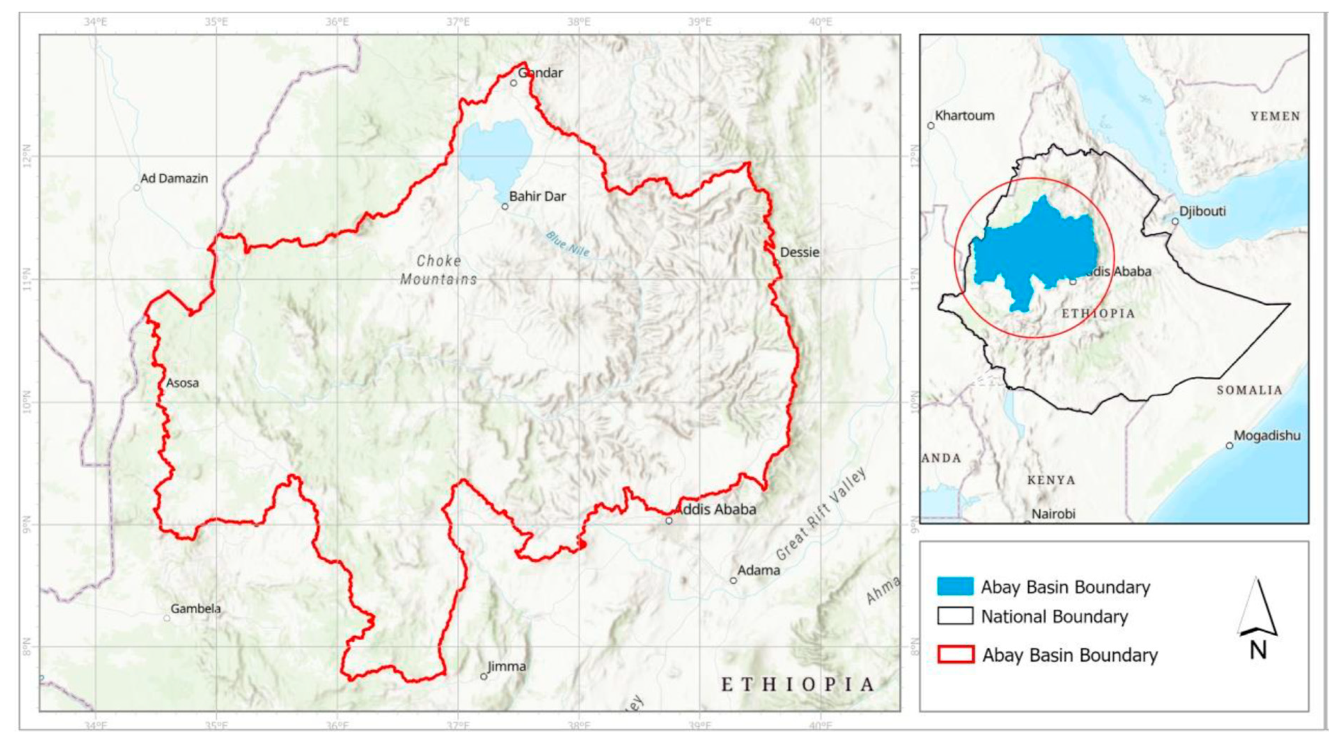
Figure 1. Map of Abbay River basin.
Preprints 84646 g001
Figure 2. General framework of clustering.
Preprints 84646 g002
Figure 3. PCA dimensions, Eigenvalue and cumulative variance.
Preprints 84646 g003
Figure 4. Cos2 factor map representing the quality of variables .
Preprints 84646 g004
Figure 5. Total number of climate clusters generated by the K-means clustering and optimum number of clusters determined by the Elbow method.
Preprints 84646 g005
Figure 6. Climate clusters in the Abbay Basin generated by the k-means clustering method.
Preprints 84646 g006
Table 1. Data used for climatic regionalization in the Abbay basin.
No Data type Source Spatial resolution Temporal resolution
1 Precipitation ENACTS ~4km 1981-2018 (daily)
2 Maximum temperature (Tmax) ENACTS ~4km 1981-2018 (daily)
3 Minimum temperature (Tmin) ENACTS ~4km 1981-2018 (daily)
4 Onset date Own analysis ~4km 1981-2018 (Annual)
5 Cessation Own analysis ~4km 1981-2018 (Annual)
6 Length of growing period (LGP) Own analysis ~4km 1981-2018 (Annual)
7 Potential evapotranspiration (PET) Own analysis ~4km 1981-2018 (daily)
8 Precipitation Concentration Index (PCI) Own analysis ~4km 1981-2018 (Annual)
9 Soil moisture Own analysis ~4km 1981-2018 (daily)
10 Elevation AsterDEM v2
Table 2. Characteristics of the climate variables in the 12 climate clusters .
Climate Clusters Rainfall onset date (pentad) Rainfall cessation date (pentad) LGP (Pentad) PCI Annual rainfall (mm) PET (mm) Soil moisture (mm) Min Tem. (⁰ C) Max Tem. (⁰ C) Mean Elevation (m asl) Rainfall cycle (number)
1 32.3 53.4 21.1 16.6 1386.4 1432.7 24.7 13.8 26.7 1561.9 1
2 33.8 53.6 19.8 18.1 1190.2 1261.2 13.4 9.2 23.1 2538.5 2
3 19.2 49.5 30.4 20.3 1006.3 1303.0 13.8 8.9 22.4 2620.3 2
4 26.1 54.3 28.2 16.2 1514.2 1425.6 62.5 14.5 28.7 1401.2 1
5 26.1 60.0 33.9 15.9 1603.8 1409.8 75.5 14.6 28.0 1458.7 1
6 31.8 53.7 21.9 16.2 1645.8 1289.1 33.5 10.8 24.3 2267.5 1
7 27.2 54.0 26.8 18.2 1423.5 1655.8 60.1 16.4 31.2 974.8 1
8 25.5 53.9 28.5 14.6 1769.5 1320.7 79.9 12.9 26.2 1846.8 1
9 33.6 53.7 20.0 19.9 1157.8 1467.0 10.6 12.4 27.0 1798.6 2
10 27.2 54.2 27.0 19.5 1198.9 1846.8 51.6 19.1 34.8 698.0 1
11 30.4 54.1 23.6 19.0 1427.5 1449.4 58.3 12.9 27.6 1755.9 1
12 34.4 49.2 14.8 21.1 1006.6 1301.3 11.5 9.0 22.0 2511.5 2
Disclaimer/Publisher’s Note: The statements, opinions and data contained in all publications are solely those of the individual author(s) and contributor(s) and not of MDPI and/or the editor(s). MDPI and/or the editor(s) disclaim responsibility for any injury to people or property resulting from any ideas, methods, instructions or products referred to in the content.
Copyright: This open access article is published under a Creative Commons CC BY 4.0 license, which permit the free download, distribution, and reuse, provided that the author and preprint are cited in any reuse.
Prerpints.org logo

Preprints.org is a free preprint server supported by MDPI in Basel, Switzerland.

Subscribe

© 2024 MDPI (Basel, Switzerland) unless otherwise stated