
Submitted:
03 October 2023
Posted:
04 October 2023
You are already at the latest version
Abstract
In regions with limited precipitation information like Peru, many studies rely on precipitation data derived from satellite products (SPPs) and reanalysis products. These products provide near-real-time information and offer global spatial coverage, making them attractive for various applications. However, it is essential to consider their uncertainties when conducting hydrological simulations, especially in a key region like the Pacific drainage (Pd), where 56% of Peruvian population resides (including the capital Lima).
This study evaluates the performance of three precipitation products: Reanalysis, ERA5-Land (top down approach), and two SPPs: GPM+SM2RAIN and SM2RAIN-ASCAT (bottom-up approaches). Hydrological modeling was conducted on 30 basins distributed across the Pd, which were grouped into five regions (I-V, ordered from south to north). The results showed that SM2RAIN-ASCAT performed well in regions I-III-IV, ERA5-Land in region II, and GPM+SM2RAIN in region V. The hydrological model GR4J was tested, and better efficiency criteria were obtained with SM2RAIN-ASCAT and GPM+SM2RAIN when comparing simulated versus observed streamflows. The hydrological modeling with SM2RAIN-ASCAT and GPM+SM2RAIN demonstrated satisfactory efficiency metrics (KGE > 0.75; NSE > 0.65). Additionally, ten hydrological signatures were quantified to assess the variability of simulated streamflows in each basin, with metrics such as Mean Flow (Q mean), 5th Quantile Flow (Q5), and 95th Quantile Flow (Q95) showing overall better performance.
Finally, the results of this study demonstrate the reliability of using bottom-up satellite products in Pd basins.
Keywords:
precipitation satellite products
; bottom up
; hydrological model
; daily discharge
; GR4J
; Peruvian pacific drainage
1. Introduction
Precipitation is considered as the most important variable in geosciences [1] due to its nature of main input in the hydrological cycle, and its application in the design of hydraulic structures, natural disaster management, weather forecasting, agricultural planning, among other fields [2,3]. However, spatio-temporal monitoring of precipitation with an extensive network of ground measurement stations across a territory is crucial [4] and is scarce in developing countries such as Peru. In recent years, various alternatives have been presented to overcome the scarcity of precipitation data, including meteorological models, radars, etc [5]. Therefore, the estimation of satellite-based precipitation products (SPPs) has emerged as a comprehensive and viable source of information, offering a global coverage and mostly being freely accessible [6,7]. Some of the most widely used satellite products worldwide are the Tropical Rainfall Measuring Mission (TRMM), Climate Hazards Group InfraRed Precipitation with Station data (CHIRPS), Global Precipitation Measurement Mission (GPM), among others [5,8]. These satellite products provide global coverage, spatial resolution in the range of 5-25 km, and temporal resolution ranging from hourly to daily and monthly, with some datasets extending from 1950 to the present.
These SPPs typically estimate precipitation based on cloud properties (top down approach). However, recent developments propose a novel approach that involves estimating precipitation from soil moisture, known as the bottom-up approach [9] Bottom-up products, such as SM2RAIN-ASCAT and GPM+SM2RAIN, stand out due to their high spatiotemporal resolution, accurately capturing local patterns and leveraging soil moisture to estimate precipitation in data-scarce areas [10,11]. Furthermore, they provide global and open access, benefiting hydrological applications and water resources management [11]. However, they exhibit uncertainty in the soil-precipitation relationship, dependence on hydrological models and sensitivity to soil conditions. In contrast, top down products, such as TRMM or reanalysis datasets like ERA5-Land, rely on observations from various sources to estimate precipitation and are integrated into complete climate systems, providing a global perspective. Although they adjust models and validate observations, they face challenges in areas with limited access, high uncertainty in sparsely observed regions, and potential errors due to simplifications in atmospheric physics [9]. Additionally, it is noted that reanalysis products like ERA5-Land have the capability to assimilate information from new stations and data, resulting in a significant increase in the amount of collected and generated information [2,12]. While this can bring benefits as more up-to-date records could be obtained, it may also introduce uncertainty due to the reliability and control of required data. Thus, the quality and quantity of available data vary over time and in different regions, which can affect the accuracy of precipitation estimates and, consequently, hydrological outcomes based on these products.
Furthermore, it is described that the main difference between the two approaches lies in the object of measurement. While the top down approach estimates instantaneous precipitation rates, the bottom-up approach estimates accumulated precipitation rates. Among the bottom-up SPPs, SM2RAIN-ASCAT and GPM+SM2RAIN are presented as some of the most recent products based on soil moisture, both available at a daily resolution with global coverage, with multiple versions, and data availability since 2007 [6,7].
SPPs are applied in basins worldwide due to their global coverage and complete precipitation records for a relatively long period. However, these benefits do not eliminate the uncertainties associated with their composition [13], which also is presented in applications such as hydrological modeling. While SPPs, when possible, are compared and adjusted with ground-based stations, they should also be evaluated for their ability to generate streamflows [14]. Hence, the major challenges lie in the conditions under which SPPs are obtained and/or generated, as well as in the effective integration of these two approaches in applications, since top down products are based on climate models and global observations, while bottom-up products rely on hydrological models and soil moisture data [10,15,16]. The heterogeneity of the data and differences in spatial and temporal scales between the approaches pose challenges in synchronizing and calibrating hydrological models. Another challenge in using SPPs for streamflow generation is the validation of hydrological models, as different performance statistics are employed, such as the Nash-Sutcliffe Efficiency (NSE), Kling-Gupta Efficiency (KGE), among others [2,4]. These criteria allow for evaluating the degree of agreement between streamflows simulated by a hydrological model. Some studies have found that bottom-up products, such as SM2RAIN-ASCAT and GPM+SM2RAIN, exhibit relatively high KGE values compared to other precipitation products, indicating good performance in replicating observed streamflows.
In Peru, SPPs have been employed in some applications due to the country's limited network of hydrometeorological stations, which makes the study of ungauged basins challenging [1,11,17,18]. This study is focused on Pacific drainage (Pd) due to its high population density, presence of major irrigation projects, reservoirs, and diverse climatic and hydrological characteristics. Due to being a region of interest, authors have carried out studies on the Pd runoff [19], and drought events have also been evaluated in the Pd [20]. Based on the literature review, it is inferred that this study is the first to evaluate and validate the performance of bottom-up approach SPPs in generating daily streamflows, as well as utilizing hydrological signatures in Pd basins.
2. Materials
2.1. Study Area
Peru covers an area of 1,285,216 km2 and is divided into three major hydrographic regions: Pacific, Amazonian and Titicaca, where Pacific drainage (Pd) covers 278,482 km² representing 21.7%. Pd accommodates nearly 56% of the country's total population, including the capital Lima with more than 10 M of people), exhibiting high spatial demographic variability across the steep slopes and a high risk to water stress and flood prone areas [21]. This study evaluated the capability of 30 basins distributed in the Pd, which were grouped into five regions as determined by the Peruvian Administrative Water Authorities (AAA) [22] (Figure 1a). Basin sizes vary in a range from 400 to 17,000 km2. They are delimited with respect to a hydrometric station. Regions I, II, III, IV, and V, defined by AAA, encompassed 5, 2, 12, 5, and 7 basins, respectively (Table 1). Figure 1a also shows the extent and spatial location of the 30 analyzed basins. In this way, basins in southern and central regions (I to III ) at an altitude higher than 3,500 a masl, while basins in northern regions (IV-V) culminate at an altitude ranging from 2,500 to 3,500 a masl.
The study area, due to its territorial extension, presents 33 of the 38 climatic zones identified in the Climate Classification Map of Peru developed by SENAMHI [23] with the remaining 5 climates found in the Amazonian and Titicaca.
Predominantly, throughout the entire Pacific drainage, there is an arid and temperate climate (Figure 1b). Thus, in regions I, II, III, and IV, a climate typified with code E (d) B (yellow) predominates, described as "Arid with moisture deficiency in all seasons of the year-Temperate". In region V, a climate typified with code E (d) A (pink) prevails, described as "Arid with moisture deficiency in all seasons of the year-Warm". Additionally, on the Pacific drainage, the predominant vegetation cover and land use are coastal and Andean agriculture and lithic leptosol-lithic outcrop soils, respectively.
On the other hand, Figure 1c displays the annual cumulative precipitation distributed along the Pacific drainage. It is noteworthy that the highest precipitation values are mainly found in the upper parts of the basins. Also, in the lower parts of the basins near the Pacific Ocean, the lowest cumulative precipitations are recorded (<100 mm/year).
2.2. Datasets
2.2.1. Surface observations
Thirty hydrometric stations in the Pd were used (Table 1) and were selected upon the criteria of having a common period of streamflow records over 2007 - 2018 (12 years). This period was then divided into calibration and validation stages.
2.2.2. Gridded precipitation products
The present research used three gridded precipitation products to evaluate their performance through streamflows simulations in the Pd. All of them were evaluated across the period from 2007 to 2018, using the GR4J hydrological model. The first evaluated product is ERA5-Land reanalysis (top down approach) from the European Centre for Medium-Range Weather Forecasts (ECMWF, Copernicus Climate Change service), as described by [24]. The other two SPPs are derived from the bottom-up approach, namely SM2RAIN-ASCAT [7] and GPM+SM2RAIN [9].
ERA5-Land reanalysis provides hourly precipitation data accumulated at the daily time step. This product stands out for its global coverage in gridded format with a spatial resolution of 9 km. It is available from January 1950 to the present and can be accessed for free through its official webpage: https://cds.climate.copernicus.eu/cdsapp#!/dataset/reanalysis-era5-land?tab=overview.
The second precipitation product used is the SPPs SM2RAIN-ASCAT, which provides daily precipitation data. This product follows a bottom-up methodology and has collected precipitation records since 2007. SM2RAIN-ASCAT has a spatial resolution of 12.5 km and is available in netCDF and raster formats. The development of this product is based on the inversion of the soil water balance equation, allowing the estimation of the amount of water entering the soil. SM2RAIN-ASCAT has been developed by [7], and different versions of the product can be found at the following link: https://zenodo.org/record/3635932#.YbfGn5FByUk.
The third product used is the SPPs GPM+SM2RAIN. This product offers quasi-global precipitation data with a spatial resolution of 25 km. Similar to the previous product, GPM+SM2RAIN follows the bottom-up methodology and combines information from GPM's IMERG-LR product with precipitation estimates based on SM2RAIN derived from ASCAT H113 H-SAF, SMOS L3, and SMAP L3 soil moisture products [4,9]. This product is available from 2007 and can be downloaded for free in netCDF format from its official webpage: https://zenodo.org/record/3854817#.YbfHfJFByUk.
In addition to the use of these three precipitation products, the PISCO precipitation product [25], developed by SENAMHI, was also employed to generate daily streamflows in the 30 basins and use these streamflows as observed values when quantifying the Skill Score (SS). Moreover, SENAMHI's evapotranspiration product [26] was used to complement the input variables for the GR4J model.
3. Methods
The development of this research was divided into three main stages: (1) Hydrological modeling with GR4J, (2) Performance evaluation of the 3 precipitation products using efficiency metrics, and (3) Evaluation of the streamflow time series using Skill Score and hydrological signatures (Figure 2).
3.1. Hydrological modeling
The model required precipitation, evapotranspiration and streamflow data from the hydrometric stations as input for calibration and validation procedures. The AirGR package, coded in the R programming language, was used for model execution and is freely available for use (https://github.com/cran/airGR).
The rainfall-runoff model used in this study is the Génie Rural à 4 paramètres Journalier (GR4J) [27]. This conceptual model is a deterministic and lumped model with four parameters at daily time step. To operate, the model requires daily precipitation and evapotranspiration data, as well as a series of observed streamflow data for the calibration and validation process.
The GR4J model is composed of two reservoirs. The first reservoir, referred to as "S," relates evapotranspiration and precipitation to determine the precipitation volume. The second reservoir, referred as "R," represents the infiltration processes within the basin. The GR4J model is widely used in hydrological studies due to its ability to simulate streamflow behavior in basins. Its structure and parameters allow for an adequate representation of key hydrological processes, making it a valuable tool for hydrological modeling and water resource management [28,29].
The model consists of four parameters (Table 2), which are adjusted during the calibration process for each case study. Additionally, two initial values, R and S, are required to initiate the simulation. The necessary initial values are described in Table 2, while Table 3 specifies the model parameters and recommends initial values.
The GR4J model has been successfully applied in various basins, in countries all around the world including Peru [30,31] and it has been widely accepted due to its parsimony in hydrology. In this study, the GR4J model was used to generate daily streamflows in 30 basins located in the Pd. The precipitation and evapotranspiration data described in the section were used as input data for the model.
3.2. Performance evaluation of the 3 precipitation products
As expected, a calibration and validation process were necessary to evaluate the model outputs and, consequently, assess the performance of the 3 precipitation products. The metrics used are detailed in Table 4, and the calibration and validation process were performed using the hydroPSO package [32], which is described on its official page (https://github.com/hzambran/hydroPSO). hydroPSO has been suitable for countless hydrological models, giving satisfactory analysis [33,34,35,36,37]. In the application of a hydrological model, it is essential to assess the agreement between simulated and observed streamflows. In this study, this evaluation was carried out using five efficiency metrics for the calibration, validation and overall periods. The efficiency metrics used are the Nash-Sutcliffe Efficiency (NSE), Kling-Gupta Efficiency (KGE), Root Mean Square Error (RMSE), Relative Bias (BIAS), and the Pearson Correlation coefficient (r). These indicators are widely used in the scientific literature and have been applied in numerous research studies [30,38,39]. Specific details about the efficiency metrics can be found in Table 4. Additionally, authors such as [40] have successfully employed these statistical indicators.
In addition, efficiency intervals were used to classify the results obtained when comparing the simulated and observed streamflow time series. These intervals provide a classification of the model performance based on the level of agreement between the simulated and observed values. They allow for a qualitative assessment of the model's ability to reproduce the observed streamflow patterns [42] (Table 5).
3.3. Evaluation of the series using Skill Score and hydrological signatures.
The use of the Skill Score allowed us to compare daily simulated streamflows from precipitation products using a reference streamflow. It determined the best product for each basin, and consequently, to select the best product for each region [14]. Additionally, to find the 10 hydrological signatures described in Table 6, a code developed in MATLAB called the Toolbox for Streamflow Signatures in Hydrology (TOSSH) [43] (https://github.com/TOSSHtoolbox/TOSSH) was used.
3.3.1. Skill Score
The Skill Score (SS) efficiency metric was implemented to evaluate the goodness-of-fit of each precipitation product (Eq. 1). This approach was adopted to account for the inherent variability of the basin under adverse streamflow generation conditions [14]. Therefore, simulated streamflows from precipitation products were compared with the streamflow simulated using PISCO precipitation product. The reference for the use of the Skill Score can be found in the work of [44].
3.3.2. Hydrological Signatures
The estimation of hydrological characteristics, known as streamflow signatures or hydrological signatures, aims to obtain a comprehensive understanding of basin behavior and evaluate the long-term reliability of precipitation products. These hydrological signatures quantify aspects related to the magnitude, frequency, duration, timing, and rate of change of hydrological events. In this study, the Toolbox for Streamflow Signatures in Hydrology (TOSSH) developed by [43] was used to calculate the hydrological signatures. This approach allowed the variability characterization of the 30-streamflow time series and the analysis of specific hydrological phenomena such as high or low flows. The calculation and analysis of these 10 hydrological signatures (Table 6) provided key information about the basins behavior, enabling a better understanding of its hydrological response.
4. Results
The evaluation of the three Satellite Precipitation Products (SPPs) revealed a range of outcomes across the entire extent of the Pacific drainage (Pd). These results underwent analysis using efficiency metrics such as the Kling-Gupta Efficiency Coefficient (KGE), the Nash-Sutcliffe Coefficient (NSE), correlation coefficient (r), and bias (BIAS). Additionally, it was observed that these results also exhibited variations depending on the analysis region and possibly influenced by factors like basin size, climate or morphological characteristics.
4.1. Performance of satellite products in the evaluation stages
The comparative analysis among the calibration, validation, and total periods reveals that, in general, all three products demonstrate reliability at various stages of the analysis (Figure 3). During the calibration period, the most closely fitting efficiency metrics were achieved, and as expected, these values decreased during the validation and the overall period.
The assessment of the three analysis periods was conducted comparing the NSE, KGE, BIAS, and RMSE metrics between the extreme and average values of the three Satellite Precipitation Products (SPPs) and visualized through boxplots.
When considering the NSE efficiency metric for the ERA5-Land product and evaluating the average values, satisfactory results were observed during the calibration period (> 0.65), acceptable results in the overall period (> 0.50), and unsatisfactory results during the validation period (< 0.50). The GPM+SM2RAIN presents the same results as those obtained with ERA5-Land.
On the other hand, the SM2RAIN-ASCAT product exhibited outstanding performance across all three periods, achieving good results during the calibration period (> 0.65), satisfactory results in the overall period (> 0.50), and satisfactory results during the validation period (> 0.50). Considering the KGE efficiency for the ERA5-Land product and evaluating the average values, very good results were obtained during the calibration period (> 0.75), good results in the overall period (> 0.65), and satisfactory results during the validation period (> 0.50). The GPM+SM2RAIN presents the same results as those obtained with ERA5-Land.
In contrast, the SM2RAIN-ASCAT product demonstrated outstanding performance in all three periods, achieving very good results during the calibration period (> 0.75), satisfactory results in the overall period (> 0.50), and again satisfactory results during the validation period (> 0.50).
Regarding the BIAS efficiency metric in the three evaluated products, it was determined that the GPM+SM2RAIN product had the mean closest to 0 in the calibration, validation, and total periods. However, it also exhibited greater variation in underestimation and overestimation. In the RMSE metric, the mean values of the products approach 0.5, and the SM2RAIN-ASCAT product shows a more stable root mean square error across all three analysis phases.
Based on the evaluation conducted in the 30 basins, it can be concluded that the evaluated products showed promising results. All three products mostly yielded results in the range of > 0.50 for the calibration stage in the NSE and KGE metrics. Most of the RMSE and BIAS results were close to 0, indicating good performance. Additionally, the r metric showed the highest number of basins in the range of 0.65.
4.2. Evaluation of the performance of precipitation products in the Pd
The performance considering the spatial variability of the 3 Satellite Precipitation Products (SPPs) in the estimation of daily mean streamflows during the calibration period is presented in Figure 5 and Figure 6. These figures provide detailed local performance in different regions within the study area.
Figure 4.
Distribution of the efficiency metrics of the 30 basins in the calibration phase. (a) BIAS; (b) r.
Figure 4.
Distribution of the efficiency metrics of the 30 basins in the calibration phase. (a) BIAS; (b) r.
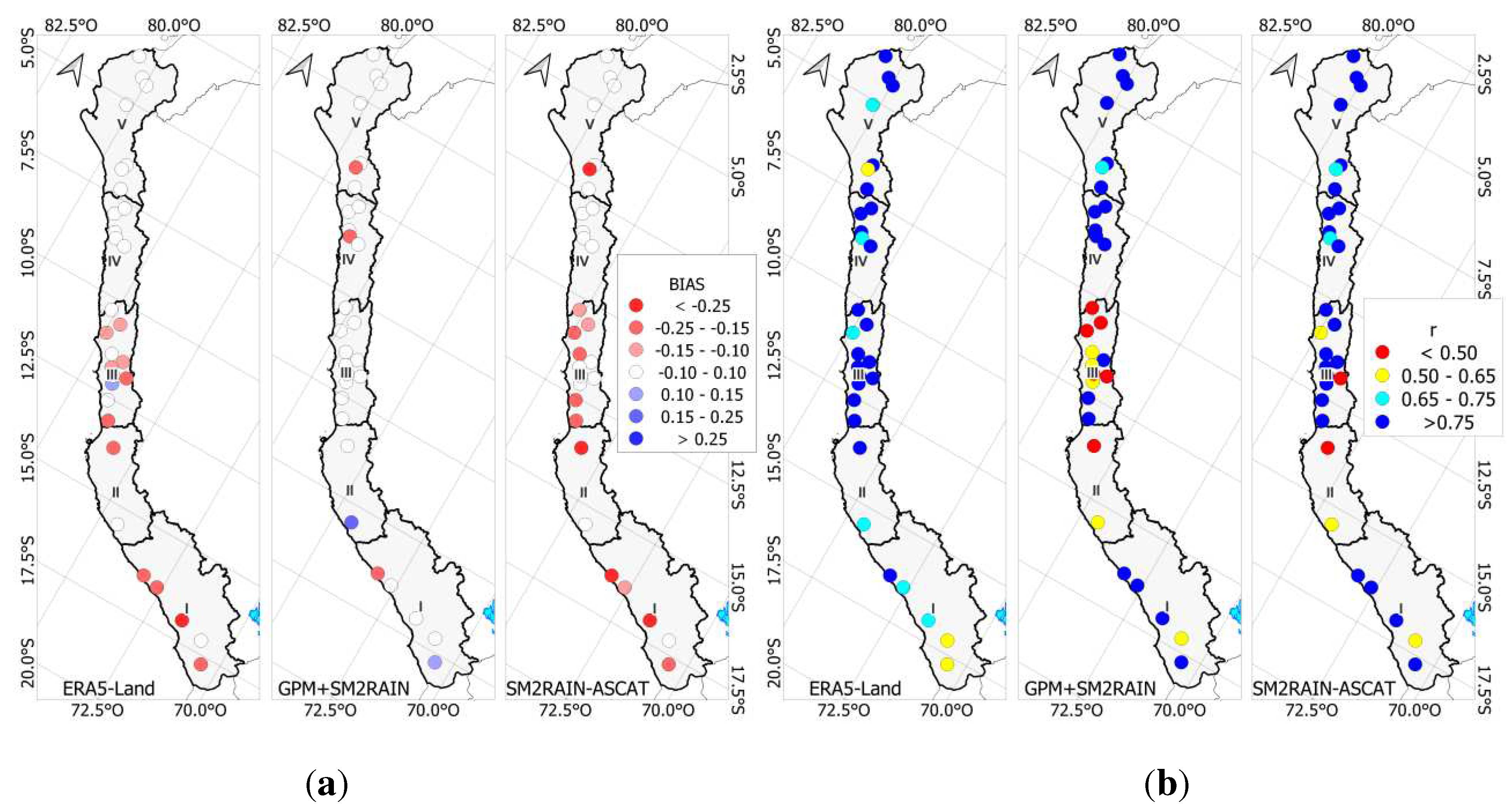
In Figure 4a, the distribution of BIAS is presented. According to Moriasi [42], this metric is considered highly satisfactory within the range of -0.10 to +10, while it is deemed unsatisfactory if the variation falls below -0.25 or above +0.25. In this representation, red color shades indicate significant underestimations, blue shades indicate marked overestimations, and white values highlight optimal results. For ERA5-Land, the most favorable results are observed in region V, while region I shows less satisfactory performance. On the other hand, the GPM+SM2RAIN product exhibits outstanding performance along the Pacific drainage, with all basins in region III yielding results within the range of -0.10 to +0.10.
Figure 4b provides an analysis of the Pearson correlation coefficient results for the study area. In this representation, red shades indicate unsatisfactory results, while blue shades reflect a high degree of agreement. For ERA5-Land, the results show satisfactory levels (r > 0.5) in all 30 basins, with exceptional performance in regions II, III, and IV. However, the lowest metric is observed only in region I. In contrast, the GPM+SM2RAIN product stands out for its performance in regions I, IV, and V, although it presents unsatisfactory results in region II and the northern part of region III.
For SM2RAIN-ASCAT, very encouraging results were obtained with Pearson correlation coefficients exceeding 0.75 in regions I, III, IV, and V. However, region II was the only one predominantly exhibiting an unsatisfactory correlation coefficient, with values below 0.5. These findings complete the comprehensive evaluation of the performance of the analyzed products in the hydrological study.
Figure 5 presents the results derived from the NSE and KGE metrics, using a color scale to indicate different levels of performance. The blue shade represents outstanding performance (>0.75), cyan denotes good performance (>0.65), yellow reflects satisfactory performance (>0.50), and red indicates unsatisfactory performance (<0.50).
In Figure 5a, the point distribution of NSE results in the study area is displayed. In this context, ERA5-Land shows the most encouraging results in region IV, while region I has the highest concentration of basins with unsatisfactory performance. On the other hand, the GPM+SM2RAIN product stands out in regions I and V, predominantly showing satisfactory results, in contrast to region II and the northern part of region III, where more basins exhibit unsatisfactory performance. Regarding SM2RAIN-ASCAT, it demonstrates very positive performance in regions I, III, and IV, while region II predominantly registers unsatisfactory results.
Similarly, Figure 5b presents the results of the KGE metric, which uses the same color scale as NSE but with higher scores. ERA5-Land exhibits outstanding results in 29 of the 30 evaluated basins, particularly in regions III and IV, with lower scores observed only in region I. GPM+SM2RAIN excels in regions IV and V but shows unsatisfactory results in the northern part of region III and region II. As for SM2RAIN-ASCAT, it stands out with very favorable results, especially in regions III, IV, and V, while region II exhibits unsatisfactory results (KGE < 0.50).
The precipitation product results exhibited variations in different regions of application, where the bottom-up approach demonstrated efficiency throughout the study area, often surpassing the performance of ERA5-Land. Figure 6 presents the results for 5 selected hydrographic basins for each region, highlighting that the best results were obtained in the northern (IV, V) and southern (I) regions, while the central region (III) exhibited greater variability in the results. Additionally, region II yielded fewer promising results for the SM2RAIN-ASCAT and GPM+SM2RAIN products, with only the ERA5-Land product providing efficient metrics.
Furthermore, in Figure 6, the calibration and validation periods are displayed, revealing a decrease in efficiency during the validation period. Streamflows generated from the Satellite Precipitation Products (SPPs) generally matched the observed records. However, in specific cases, such as in regions II and III, ASCAT-SM2RAIN and GPM+SM2RAIN struggled to match during low flow periods. It is also observed that in some basins, flow records had gaps, as shown in Figure 6b, where the absence of flow data is evident for the years 2011-2013.
Figure 6 also illustrates the monthly hydrological regime of observed flow and the time series of simulated flow derived from the precipitation products. This analysis of the hydrological regime demonstrates the similarity between simulated and observed flows during high flow and low flow periods. For example, this similarity is particularly noticeable in regions II, III, and V. In contrast, in region IV, there is a clear overestimation during low flow months by ASCAT-SM2RAIN and GPM+SM2RAIN. Additionally, Figure 6 also shows the variation in flow according to the chosen region, and this variation is influenced by spatial location (increased flow from south to north). However, these differences in flows are also due to the extent of the studied basin.
4.3. Spatial performance evaluation by areas of the precipitation products
From the previous analysis, it is evident that the basins demonstrate a robust hydrological response over the study period (with Pd efficiency metrics ranging from 0.5 to 0.75). However, it is also clear that the evaluated basins vary in terms of size in square kilometers (km²), which could influence the flow response. Figure 7 displays histograms organized according to the results of the Kling-Gupta Efficiency Coefficient (KGE) and segmented into ranges based on the Moriasi classification (Unsatisfactory < 0.5; Satisfactory 0.50-0.65; Good 0.65-0.75; and Very Good 0.75-1.00). In addition to the range segmentation, the 30 basins were distributed into 4 categories: basins less than 1,000 km², 1,000 to 2,500 km², 2,500 to 5,000 km², and over 5,000 km².
In basins smaller than 1,000 km² (8 basins), ERA5-Land achieved a KGE greater than 0.5 (Satisfactory) in all 8 basins, primarily excelling with 5 basins rated as Satisfactory and the remaining 3 with Good and Very Good ratings. In contrast, GPM+SM2RAIN achieved a KGE greater than 0.5 in 4 out of the 8 basins, resulting in 1 basin with a Satisfactory rating and 3 with Good ratings. For SM2RAIN-ASCAT, a KGE greater than 0.5 was recorded in 7 out of the 8 basins, resulting in 4 Satisfactory and 3 Very Good ratings. Subsequently, for basins with areas between 1,000 and 2,500 km² (10 basins), ERA5-Land achieved a KGE greater than 0.5 in 9 out of the 10 basins, with 7 basins demonstrating Very Good performance. GPM+SM2RAIN, on the other hand, achieved a KGE greater than 0.5 in 8 out of the 10 basins, with Satisfactory (4), Good (1), and Very Good (3) results. Similarly, SM2RAIN-ASCAT surpassed the threshold of 0.5 in all 10 basins, standing out with 8 basins in the Very Good category (>0.75).
In relation to basins with areas between 2,500 and 5,000 km² (7 basins), ERA5-Land obtained a KGE greater than 0.5 in all 7 basins, with remarkable performance in 4 basins in the Very Good category. GPM+SM2RAIN exceeded the value of 0.5 in 4 out of the 7 basins, resulting in Satisfactory (1), Good (1), and Very Good (2) ratings. SM2RAIN-ASCAT achieved results above Satisfactory in 5 out of the 7 basins, with ratings of Good (2) and Very Good (3). Finally, for basins larger than 5,000 km² (5 basins), all three SPPs presented results above Satisfactory. Among them, GPM+SM2RAIN demonstrated the highest number of Very Good results (5 basins), followed by SM2RAIN-ASCAT with Good (3) and Very Good (2) ratings, while ERA5-Land had 2 Satisfactory basins, 1 Good basin, and 2 Very Good basins.
4.4. Improved performance
The quantification of the efficiency metrics NSE, KGE, RMSE, r, and BIAS showed a satisfactory performance of the precipitation products in generating simulated daily streamflows. However, this study aims to determine the best product for each hydrographic basin and the defined region by the AAA. Therefore, the Skill Score (SS) index was used, which involved comparing the simulated flows from the 3 products with a reference streamflow. Although 30 hydrometric stations were used for the calibration and validation stage, these records had missing data for multiple years. Thus, they could not be used to quantify the Skill Score, as this metric requires a complete time series. In this context, the streamflows generated by PISCO in each of the basins were used as the reference flow of comparison. The results are shown in Figure 8. Among the 30 analyzed basins, ERA5-Land, GPM+SM2RAIN, and SM2RAIN-ASCAT were predominant in 5, 12, and 13 basins, respectively. Additionally, in the northern zone of region 5, there is a predominance of the GPM+SM2RAIN product. In region 4, the SM2RAIN-ASCAT and GPM+SM2RAIN products showed predominance in 2 basins each one. In region 3, SM2RAIN-ASCAT predominated in the northern part, while GPM+SM2RAIN predominated in the southern part. In region 2, ERA5-Land predominated, and finally, in region 1, GPM+SM2RAIN predominated.
4.5. Reliability of remote sensing products on hydrologic signatures
The variability of the simulated streamflows was quantified using hydrological signatures, where it is worth noting that the signatures with the best performance were Mean Q, Q95, Q5, and Q7, respectively, as they consistently obtained values above 0.80 on average. On the other hand, the BFI and DL signatures had average values below 0.5. Figure 9 provides a quantitative (left) and qualitative (right) analysis to identify the performance of each product with respect to the hydrological signature. It is also important to note that the performance of the precipitation product and the hydrological model is not uniform across all basins, which could be attributed to the characteristics of the precipitation products or the functioning scheme of the hydrological model. In region I, the product that showed the best response was GPM+SM2RAIN, with Mean Q being the best-represented signature and Low Frequency being the worst-represented. In region II, GPM+SM2RAIN showed the best response, with Minimum 7-day Flow as the best-represented signature and High Duration as the worst-represented. In region III, the product that showed the best response was GPM+SM2RAIN, with Low Frequency being the best-represented signature and High Duration being the worst-represented. In region IV, SM2RAIN-ASCAT showed the best response, with Minimum 7-day Flow as the best-represented signature and Base Flow Index as the worst-represented. In region V, SM2RAIN-ASCAT showed the best response. Q95 was the best-represented signature and Long Duration was the worst-represented. Thus, the evaluation of the precipitation products performance using hydrological signatures allowed for the identification of best representations of maximum, minimum, and base flow streamflows, highlighting that these products better represent average streamflows.
5. Discussions
5.1. Intrinsic quality of satellite precipitation products
The evaluation conducted on gridded products using a bottom-up approach allowed us to comprehend and interpret the performance of each product along the Pacific drainage and establish connections between the results and the climatic and physiographic characteristics of the basins. The performance against observed records was validated using efficiency metrics such as NSE, KGE, RMSE, BIAS, and r.
Products like SM2RAIN-ASCAT and GPM+SM2RAIN have demonstrated satisfactory outcomes in their application in basins worldwide [18,45], occasionally surpassing other satellite-based precipitation products (SPPs). Nevertheless, the effectiveness of soil moisture-based products also depends on the topographical, climatic, and other specific conditions of the basin, and in some cases, they may be outperformed by other SPPs [46].
For instance, SM2RAIN-ASCAT and SM2RAIN-CCI products exhibit higher accuracy in arid areas such as the Peruvian and Bolivian Altiplano region than in the southern Asia region in Pakistan [10]. This precision is also confirmed in our study area. This disparity can be attributed to the more favorable physical environment for satellite-based soil moisture (SM) estimations in the Altiplano region.
Furthermore, [11], compared various SPPs in a mountainous basin with a humid subtropical monsoonal climate in southern China and found that other SPPs adapted better than bottom-up-focused SPPs to the basins climatology. This could be mainly attributed to the steep slopes in the mountainous basin and the predominant climate due to geographical location. Likewise, in this study, results varied depending on the exposed climatology, received precipitation, and basin size. As demonstrated by [47] in Pakistan, basins with precipitation exceeding 700 mm did not yield encouraging results, whereas basins with precipitation below 100 mm (arid and hyper-arid zones) exhibited Very Good adjustments, as observed in the results presented in this research. It should be noted that precipitation is generally directly proportional to altitude, which implies that basins predominantly featuring flat areas may yield better results, just as demonstrated by various authors [48,49,50].
Prominent discrepancies and sources of uncertainty in these areas arise from the impact of complex topography and climatic variability, phenomena extensively documented in previous research [17,51]. Thus, the results of this investigation demonstrated that the efficiency of SPPs is related to the slope and extent of the basin. Small, steep basins like Supe encountered difficulties in replicating observed streamflows, while, conversely, large, low-gradient basins like Camaná displayed Very Good results (NSE>0.75).
It is anticipated that the most significant positive or negative biases will manifest in SM2RAIN-based products in forested areas with dense vegetation cover (such as glaciers and mountainous regions in wet regions), where satellite sensors may be interpreted as unable to penetrate dense vegetation [52] or in regions where the soil remains saturated for prolonged periods, such as inundated areas (specifically in hydraulically developed areas in wet regions) [53].
5.2. Performance of hydrological modeling on the Pd
The Pacific drainage (Pd) is an important region, making it crucial to adapt new methodologies related to water resource availability, such as the assessment of Underexplored Satellite Precipitation Products (SPPs) in South America. In this context, selecting an appropriate hydrological model is a significant task. In this study, the GR4J model, similar to other authors [54]. was chosen. This model was selected because it has demonstrated satisfactory results (NSE>0.5) in several basins in Peru [16,28,55,56].
While the GR4J model showed very promising results in this research, it is worth noting that some basins obtained unsatisfactory metrics for all three SPPs, as observed at the Yauca hydrometric station. These modeling uncertainties could be attributed to basins like Yauca having insufficient streamflow records (3 years), which hindered the calibration process. Unlike other semi-distributed or distributed models like SWAT, TOPMODEL, and TOPKAPI, the GR4J model is a lumped model with 4 parameters and 2 functioning tanks, which may be inadequate for basins with diverse climates and complex topographies. Additionally, it should be noted that in basins with significant human intervention, such as the Rímac basin, the adaptation of the GR4J model can be further complicated since streamflows may not be naturalized.
Despite experiencing a variety of climates, the Pacific drainage (Pd) showed that GR4J could produce satisfactory results, even in arid climates [47]. Furthermore, the evaluation of SPPs and the GR4J model also encompassed basins of different sizes in square kilometers (km²), demonstrating that the best results were obtained when assessing large basins (>5000 km²). These favorable results in larger basins could be interpreted as the areal averaging of meteorological data helping to correct underestimations or overestimations. In large basins, these data may capture more pixels from both the upper and lower parts of the basin, providing a more robust and representative average.
The favorable outcomes of GR4J in the arid climate of the Pd align with findings from other researchers [11]. As expected, the model was validated using widely accepted efficiency metrics such as NSE, KGE, RMSE, BIAS, and r, as several authors have done [27,31]. Additionally, the use of a Skill Score and hydrological signatures allowed us to understand various aspects, including limitations related to the optimal periods for using Soil Moisture-derived products.
Authors like [57], describe that during the summer period, all Satellite Precipitation Products (SPPs) exhibited a significant number of overestimations or underestimations, similar to what occurs in some regions of the Pd, as observed in Figure 6 of this study. According to [57], during the summer season, all SPPs showed a tendency towards underestimations, which is consistent with the results in Figure 4a, where underestimations are observed in the BIAS metric. Previous research, such as [58], concluded that the correlation coefficient increases proportionally with precipitation intensity. Conversely, errors decreased as precipitation intensity increased, an observation that aligns with the results of our current research (Figure 6 and Figure 4b).
6. Conclusions
This study evaluated the performance of 3 precipitation products. Two are based on bottom-up approaches in the Pd of Peru for estimating daily mean streamflows. Additionally, the performance of daily streamflows produced by the products was assessed using efficiency metrics and hydrological signatures. A total of 30 basins were evaluated using the GR4J hydrological model at a daily time step, grouped into 5 administrative regions. It was found that in at least 90% of the basins, evaluated products showed satisfactory results (NSE, KGE > 0.5) during the calibration stage, while scores decreased during the validation and total period.
Spatial analysis with efficiency metrics, showed that for NSE metric, the SM2RAIN-ASCAT product performed the best in two analysis periods (calibration and total), with an average metric value of 0.50 (Satisfactory). Similarly, for the KGE metric, the product that performed the best in all three analysis periods was SM2RAIN-ASCAT, with an average metric value of 0.50 (Satisfactory). Furthermore, for the BIAS metric, the most conservative product with a value close to 0 during the calibration stage was GPM+SM2RAIN. Regarding the RMSE metric, the product that performed the best was SM2RAIN-ASCAT.
In terms of spatial extent, it was determined that for basins with an area less than 1000 km2, the best product was ERA5-Land. For basins with an area between 1,000 and 2,500 km2, SM2RAIN-ASCAT yielded the best results. Subsequently, for basins with an area between 2500-5000 km2, ERA5-Land was the best product. Finally, for basins with an area greater than 5000 km2, the best product was GPM+SM2RAIN.
On the other hand, results using Skill Score (SS) showed that the best products by region were: SM2RAIN-ASCAT for Region I, ERA5-Land for Region II, SM2RAIN-ASCAT for Region III, SM2RAIN-ASCAT for Region IV, and GPM+SM2RAIN for Region V. While the best product was determined for each region, this does not limit the use of other satellite products, as in Region III, for example, it is notable that SM2RAIN-ASCAT prevails in the northern zone while GPM+SM2RAIN prevails in the southern zone.
Based on the analysis using hydrological signatures, it was concluded that in Region I, the best product is GPM+SM2RAIN; in Region II, it is GPM+SM2RAIN; in Region III, it is GPM+SM2RAIN; in Region IV, it is SM2RAIN-ASCAT; and in Region V, it is SM2RAIN-ASCAT. These products had the highest number of satisfactory hydrological signatures.
Finally, this study demonstrated that the bottom-up approach presents advantages to the ERA5-Land in some Pd regions, mainly in areas with high precipitation or significant soil moisture. The use of SPPs under a bottom-up approach is recommended in the Pd, and further exploration in other regions of the Peruvian territory is also suggested.
Acknowledgments
J. Qquenta y W. Lavado thank support from SENAMHI. P. Rau thanks support from the fund KF400238 British Academy: “Furia de los Rios” project.
References
- Maggioni, V.; Massari, C. On the Performance of Satellite Precipitation Products in Riverine Flood Modeling: A Review. J. Hydrol. 2018, 558, 214–224. [Google Scholar] [CrossRef]
- Eini, M.R.; Rahmati, A.; Salmani, H.; Brocca, L.; Piniewski, M. Detecting Characteristics of Extreme Precipitation Events Using Regional and Satellite-Based Precipitation Gridded Datasets over a Region in Central Europe. Sci. Total Environ. 2022, 852, 158497. [Google Scholar] [CrossRef] [PubMed]
- Muhammad, E.; Muhammad, W.; Ahmad, I.; Muhammad Khan, N.; Chen, S. Satellite Precipitation Product: Applicability and Accuracy Evaluation in Diverse Region. Sci. China Technol. Sci. 2020, 63, 819–828. [Google Scholar] [CrossRef]
- Brocca, L.; Massari, C.; Pellarin, T.; Filippucci, P.; Ciabatta, L.; Camici, S.; Kerr, Y.H.; Fernández-Prieto, D. River Flow Prediction in Data Scarce Regions: Soil Moisture Integrated Satellite Rainfall Products Outperform Rain Gauge Observations in West Africa. Sci. Rep. 2020, 10, 1–14. [Google Scholar] [CrossRef] [PubMed]
- Hong, Y.; Hsu, K.L.; Moradkhani, H.; Sorooshian, S. Uncertainty Quantification of Satellite Precipitation Estimation and Monte Carlo Assessment of the Error Propagation into Hydrologic Response. Water Resour. Res. 2006, 42, 1–15. [Google Scholar] [CrossRef]
- Brocca, L.; Moramarco, T.; Melone, F.; Wagner, W. A New Method for Rainfall Estimation through Soil Moisture Observations. Geophys. Res. Lett. 2013, 40, 853–858. [Google Scholar] [CrossRef]
- Brocca, L.; Filippucci, P.; Hahn, S.; Ciabatta, L.; Massari, C.; Camici, S.; Schüller, L.; Bojkov, B.; Wagner, W. SM2RAIN-ASCAT (2007-2018): Global Daily Satellite Rainfall Data from ASCAT Soil Moisture Observations. Earth Syst. Sci. Data 2019, 11, 1583–1601. [Google Scholar] [CrossRef]
- Abera, W.; Formetta, G.; Brocca, L.; Rigon, R. Modeling the Water Budget of the Upper Blue Nile Basin Using the JGrass-NewAge Model System and Satellite Data. Hydrol. Earth Syst. Sci. 2017, 21, 3145–3165. [Google Scholar] [CrossRef]
- Massari, C.; Brocca, L.; Pellarin, T.; Abramowitz, G.; Filippucci, P.; Ciabatta, L.; Maggioni, V.; Kerr, Y.; Fernandez Prieto, D. A Daily 25 Km Short-Latency Rainfall Product for Data-Scarce Regions Based on the Integration of the Global Precipitation Measurement Mission Rainfall and Multiple-Satellite Soil Moisture Products. Hydrol. Earth Syst. Sci. 2020, 24, 2687–2710. [Google Scholar] [CrossRef]
- Satgé, F.; Hussain, Y.; Molina-Carpio, J.; Pillco, R.; Laugner, C.; Akhter, G.; Bonnet, M.P. Reliability of SM2RAIN Precipitation Datasets in Comparison to Gauge Observations and Hydrological Modelling over Arid Regions. Int. J. Climatol. 2021, 41, E517–E536. [Google Scholar] [CrossRef]
- Guo, B.; Xu, T.; Yang, Q.; Zhang, J.; Dai, Z.; Deng, Y.; Zou, J.; Ling, F.; Nakamura, K.; Guo, B.; et al. Multiple Spatial and Temporal Scales Evaluation of Eight Satellite Precipitation Products in a Mountainous Catchment of South China. Remote Sens. 2023, 15, 1373. [Google Scholar] [CrossRef]
- Paredes-Trejo, F.; Barbosa, H.; dos Santos, C.A.C. Evaluation of the Performance of SM2RAIN-Derived Rainfall Products over Brazil. Remote Sens. 2019, 11, 1113. [Google Scholar] [CrossRef]
- Ciabatta, L.; Massari, C.; Brocca, L.; Gruber, A.; Reimer, C.; Hahn, S.; Paulik, C.; Dorigo, W.; Kidd, R.; Wagner, W. SM2RAIN-CCI: A New Global Long-Term Rainfall Data Set Derived from ESA CCI Soil Moisture. Earth Syst. Sci. Data 2018, 10, 267–280. [Google Scholar] [CrossRef]
- Almagro, A.; Oliveira, P.T.S.; Meira Neto, A.A.; Roy, T.; Troch, P. CABra: A Novel Large-Sample Dataset for Brazilian Catchments. Hydrol. Earth Syst. Sci. 2021, 25, 3105–3135. [Google Scholar] [CrossRef]
- Hachmi, A. New Investigation and Challenge for Spatiotemporal Drought Monitoring Using Bottom-Up Precipitation Dataset (SM2RAIN-ASCAT) and NDVI in Moroccan Arid and Semi-Arid Rangelands. [CrossRef]
- Satgé, F.; Pillot, B.; Roig, H.; Bonnet, M.P. Are Gridded Precipitation Datasets a Good Option for Streamflow Simulation across the Juruá River Basin, Amazon? J. Hydrol. 2021, 602, 126773. [Google Scholar] [CrossRef]
- Ur Rahman, K.; Shang, S.; Shahid, M.; Li, J. Developing an Ensemble Precipitation Algorithm from Satellite Products and Its Topographical and Seasonal Evaluations Over Pakistan. Remote Sens. 2018, 10, 1835. [Google Scholar] [CrossRef]
- Zhang, L.; Li, X.; Cao, Y.; Nan, Z.; Wang, W.; Ge, Y.; Wang, P.; Yu, W. Evaluation and Integration of the Top-down and Bottom-up Satellite Precipitation Products over Mainland China. J. Hydrol. 2020, 581, 124456. [Google Scholar] [CrossRef]
- Rau, P.; Bourrel, L.; Labat, D.; Ruelland, D.; Frappart, F.; Lavado, W.; Dewitte, B.; Felipe, O. Assessing Multidecadal Runoff (1970–2010) Using Regional Hydrological Modelling under Data and Water Scarcity Conditions in Peruvian Pacific Catchments. Hydrol. Process. 2019, 33, 20–35. [Google Scholar] [CrossRef]
- Curi Tapahuasco, S. Caracterización de de Las Sequías Hidrológicas En La Vertiente Peruana Del Océano Pacífico. Univ. Nac. Agrar. La Molina 2017.
- Rau, P.; Bourrel, L.; Labat, D.; Frappart, F.; Ruelland, D.; Lavado, W.; Dewitte, B.; Felipe, O. Hydroclimatic Change Disparity of Peruvian Pacific Drainage Catchments. Theor. Appl. Climatol. 2018, 134, 139–153. [Google Scholar] [CrossRef]
- ANA Demarcación y Delimitación de Las Autoridades Administrativas Del Agua. Aut. Nac. del Agua 2009, 1, 48.
- Perú, S.N. de M. e H. del Climas Del Perú: Mapa de Clasificación Climática Nacional, Resumen Ejecutivo. Repos. Inst. SENAMHI. 2020.
- Hersbach, H.; Bell, B.; Berrisford, P.; Hirahara, S.; Horányi, A.; Muñoz-Sabater, J.; Nicolas, J.; Peubey, C.; Radu, R.; Schepers, D.; et al. The ERA5 Global Reanalysis. Q. J. R. Meteorol. Soc. 2020, 146, 1999–2049. [Google Scholar] [CrossRef]
- Aybar Camacho, C.L.; Lavado-Casimiro, W.; Huerta, A.; Fernández Palomino, C.; Vega-Jácome, F.; Sabino Rojas, E.; Felipe-Obando, O. Uso Del Producto Grillado PISCO de Precipitación En Estudios, Investigaciones y Sistemas Operacionales de Monitoreo y Pronóstico Hidrometeorológico. Nota Técnica No 001 SENAMHI-DHI-2017. Repos. Inst. SENAMHI 2017.
- Huerta, A.; Bonnesoeur, V.; Cuadros-Adriazola, J.; Gutierrez, L.; Ochoa-Tocachi, B.F.; Román-Dañobeytia, F.; Lavado-Casimiro, W. PISCOeo_pm, a Reference Evapotranspiration Gridded Database Based on FAO Penman-Monteith in Peru. Sci. Data 2022 91 2022, 9, 1–18. [Google Scholar] [CrossRef]
- Perrin, C.; Michel, C.; Andréassian, V. Improvement of a Parsimonious Model for Streamflow Simulation. J. Hydrol. 2003, 279, 275–289. [Google Scholar] [CrossRef]
- Asurza Véliz, F.A.; Ramos Taipe, C.L.; Lavado Casimiro, W.S. Evaluación de Los Productos Tropical Rainfall Measuring Mission (TRMM) y Global Precipitation Measurement (GPM) En El Modelamiento Hidrológico de La Cuenca Del Río Huancané, Perú. Sci. Agropecu. 2018, 9, 53–62. [Google Scholar] [CrossRef]
- Antonio, T.-F.M.; Dionicio, V.-L.J.; Abel, C.-A.; Hídricos, R.; Edmundo, V.-M.; De Empresas, A. Daily Flow Generation Using the GR4j Model and ERA5 Gridded Climatic Information in the Jequetepeque Basin up to the Yonan Station.
- Astorayme Valenzuela, M.A. Análisis y Evaluación Comparativa de Modelos Hidrológicos Agrupados y Semidistribuidos Aplicados Al Pronóstico de Caudales Diarios Del Río Chillón. Univ. Nac. Mayor San Marcos 2017.
- Metzger Modelamiento Hidrológico Del Río Zarumilla. Serv. Nac. Meteorol. e Hidrol. del Perú 2016.
- Zambrano-Bigiarini, M.; Rojas, R. A Model-Independent Particle Swarm Optimisation Software for Model Calibration. Environ. Model. Softw. 2013, 43, 5–25. [Google Scholar] [CrossRef]
- Kundu, D.; Vervoort, R.W.; van Ogtrop, F.F. The Value of Remotely Sensed Surface Soil Moisture for Model Calibration Using SWAT. Hydrol. Process. 2017, 31, 2764–2780. [Google Scholar] [CrossRef]
- Thiemig, V.; Rojas, R.; Zambrano-Bigiarini, M.; De Roo, A. Hydrological Evaluation of Satellite-Based Rainfall Estimates over the Volta and Baro-Akobo Basin. J. Hydrol. 2013, 499, 324–338. [Google Scholar] [CrossRef]
- Alfieri, L.; Burek, P.; Feyen, L.; Forzieri, G. Global Warming Increases the Frequency of River Floods in Europe. Hydrol. Earth Syst. Sci. 2015, 19, 2247–2260. [Google Scholar] [CrossRef]
- Bisselink, B.; Zambrano-Bigiarini, M.; Burek, P.; de Roo, A. Assessing the Role of Uncertain Precipitation Estimates on the Robustness of Hydrological Model Parameters under Highly Variable Climate Conditions. J. Hydrol. Reg. Stud. 2016, 8, 112–129. [Google Scholar] [CrossRef]
- Brauer, C.C.; Teuling, A.J.; F. Torfs, P.J.J.; Uijlenhoet, R. The Wageningen Lowland Runoff Simulator (WALRUS): A Lumped Rainfall-Runoff Model for Catchments with Shallow Groundwater. Geosci. Model Dev. 2014, 7, 2313–2332. [Google Scholar] [CrossRef]
- Llauca, H.; Lavado-Casimiro, W.; Montesinos, C.; Santini, W.; Rau, P. PISCO_HyM_GR2M: A Model of Monthly Water Balance in Peru (1981–2020). Water 2021, 13, 1048. [Google Scholar] [CrossRef]
- Qquenta, J.G.; Astorayme, M.A.; Gutiérrez, R.R.; Lavado, W.S. Assessment, Evaluation, and Code Development of the Particle Swarm Optimisation (PSO) Method for an Automatic Calibration of the TOPMODEL. World Environ. Water Resour. Congr. 2022 Adapt. Plan. Des. an Age Risk Uncertain. - Sel. Pap. from World Environ. Water Resour. Congr. 2022, 2022, 1232–1241. [Google Scholar] [CrossRef]
- Hwang, S.H.; Ham, D.H.; Kim, J.H. Une Nouvelle Mesure de l’efficacité Des Modéles Hydrologiques de Prévision Pilotés Par Les Données. Hydrol. Sci. J. 2012, 57, 1257–1274. [Google Scholar] [CrossRef]
- García RS MINERVE – Technical Manual. Technical Report, RS MINERVE Group. Available online: https://scholar.google.com/scholar?hl=en&as_sdt=0%2C5&q=Garc´ıa%2C+J.%2C+Paredes%2C+J.%2C+Foehn%2C+A.%2C+and+Roquier%2C+B.+%282016%29.+RS+MINERVE+–+Technical+manual.+Technical+report%2C+RS+MINERVE+Group.&btnG= (accessed on 18 June 2023).
- Moriasi, D.N.; Gitau, M.W.; Pai, N.; Daggupati, P.; Gitau, M.W.; Member, A.; Moriasi, D.N. HYDROLOGIC AND WATER QUALITY MODELS: PERFORMANCE MEASURES AND EVALUATION CRITERIA. Trans. ASABE 58, 1763–1785. [CrossRef]
- Gnann, S.J.; Coxon, G.; Woods, R.A.; Howden, N.J.K.; McMillan, H.K. TOSSH: A Toolbox for Streamflow Signatures in Hydrology. Environ. Model. Softw. 2021, 138, 104983. [Google Scholar] [CrossRef]
- Jiang, L.; Bauer-Gottwein, P. How Do GPM IMERG Precipitation Estimates Perform as Hydrological Model Forcing? Evaluation for 300 Catchments across Mainland China. J. Hydrol. 2019, 572, 486–500. [Google Scholar] [CrossRef]
- Fan, Y.; Ma, Z.; Ma, Y.; Ma, W.; Xie, Z.; Ding, L.; Han, Y.; Hu, W.; Su, R. Respective Advantages of “Top-Down” Based GPM IMERG and “Bottom-Up” Based SM2RAIN-ASCAT Precipitation Products Over the Tibetan Plateau. J. Geophys. Res. Atmos. 2021, 126, e2020JD033946. [Google Scholar] [CrossRef]
- Hamza, A.; Anjum, M.N.; Cheema, M.J.M.; Chen, X.; Afzal, A.; Azam, M.; Shafi, M.K.; Gulakhmadov, A. Assessment of IMERG-V06, TRMM-3B42V7, SM2RAIN-ASCAT, and PERSIANN-CDR Precipitation Products over the Hindu Kush Mountains of Pakistan, South Asia. Remote Sens. 2020, Vol. 12, Page 3871 2020, 12, 3871. [Google Scholar] [CrossRef]
- Prakash, S. Performance Assessment of CHIRPS, MSWEP, SM2RAIN-CCI, and TMPA Precipitation Products across India. J. Hydrol. 2019, 571, 50–59. [Google Scholar] [CrossRef]
- Amjad, M.; Yilmaz, M.T.; Yucel, I.; Yilmaz, K.K. Performance Evaluation of Satellite- and Model-Based Precipitation Products over Varying Climate and Complex Topography. J. Hydrol. 2020, 584, 124707. [Google Scholar] [CrossRef]
- Gebremicael, T.G.; Deitch, M.J.; Gancel, H.N.; Croteau, A.C.; Haile, G.G.; Beyene, A.N.; Kumar, L. Satellite-Based Rainfall Estimates Evaluation Using a Parsimonious Hydrological Model in the Complex Climate and Topography of the Nile River Catchments. Atmos. Res. 2022, 266, 105939. [Google Scholar] [CrossRef]
- Li, X.; Zhang, Q.; Xu, C.Y. Assessing the Performance of Satellite-Based Precipitation Products and Its Dependence on Topography over Poyang Lake Basin. Theor. Appl. Climatol. 2014, 115, 713–729. [Google Scholar] [CrossRef]
- Iqbal, M.F.; Athar, H. Validation of Satellite Based Precipitation over Diverse Topography of Pakistan. Atmos. Res. 2018, 201, 247–260. [Google Scholar] [CrossRef]
- Rodríguez-Fernández, N.J.; Muñoz Sabater, J.; Richaume, P.; De Rosnay, P.; Kerr, Y.H.; Albergel, C.; Drusch, M.; Mecklenburg, S. SMOS Near-Real-Time Soil Moisture Product: Processor Overview and First Validation Results. Hydrol. Earth Syst. Sci. 2017, 21, 5201–5216. [Google Scholar] [CrossRef]
- Brocca, L.; Ciabatta, L.; Massari, C.; Moramarco, T.; Hahn, S.; Hasenauer, S.; Kidd, R.; Dorigo, W.; Wagner, W.; Levizzani, V. Soil as a Natural Rain Gauge: Estimating Global Rainfall from Satellite Soil Moisture Data. J. Geophys. Res. Atmos. 2014, 119, 5128–5141. [Google Scholar] [CrossRef]
- Pino-Vargas, E.; Chávarri-Velarde, E.; Ingol-Blanco, E.; Mejía, F.; Cruz, A.; Vera, A. Impacts of Climate Change and Variability on Precipitation and Maximum Flows in Devil’s Creek, Tacna, Peru. Hydrol. 2022, 9, 10. [Google Scholar] [CrossRef]
- Risco, E.; Lavado, W.; Rau, P.; Risco, E.; Lavado, W.; Rau, P. Snow-Hydrological Modeling Using Remote Sensing Data in Vilcanota Basin, Peru. EGUGA 2020, 11515. [Google Scholar] [CrossRef]
- Satgé, F.; Ruelland, D.; Bonnet, M.-P.; Molina, J.; Pillco, R. Consistency of Satellite Precipitation Estimates in Space and over Time Compared with Gauge Observations and Snow-Hydrological Modelling in the Lake Titicaca Region. Hydrol. Earth Syst. Sci. Discuss. 2018, 1–41. [Google Scholar] [CrossRef]
- Ushio, T.; Sasashige, K.; Kubota, T.; Shige, S.; Okamoto, K.; Aonashi, K.; Inoue, T.; Takahashi, N.; Iguchi, T.; Kachi, M.; et al. A Kalman Filter Approach to the Global Satellite Mapping of Precipitation (GSMaP) from Combined Passive Microwave and Infrared Radiometric Data. J. Meteorol. Soc. Japan. Ser. II 2009, 87A, 137–151. [Google Scholar] [CrossRef]
- Paredes-Trejo, F.; Barbosa, H.A.; Spatafora, L.R. Assessment of SM2RAIN-Derived and State-of-the-Art Satellite Rainfall Products over Northeastern Brazil. Remote Sens. 2018, 10, 1093. [Google Scholar] [CrossRef]
Figure 1.
(a) Map of location and elevation of the 30 basins along the Pacific drainage (Pd). Discretization of the Pd into 5 studied regions (Region I: Caplina-Ocoña; Region II: Chaparra-Chincha; Region III: Cañete-Fortaleza; Region IV: Huarmey-Chicama; Region V: Jequetepeque-Zarumilla; (b) Climate classification map developed by SENAMHI along the Pacific drainage and (c) Multiannual accumulated precipitation map in the Pacific drainage elaborated from SENAMHI's PISCO data.
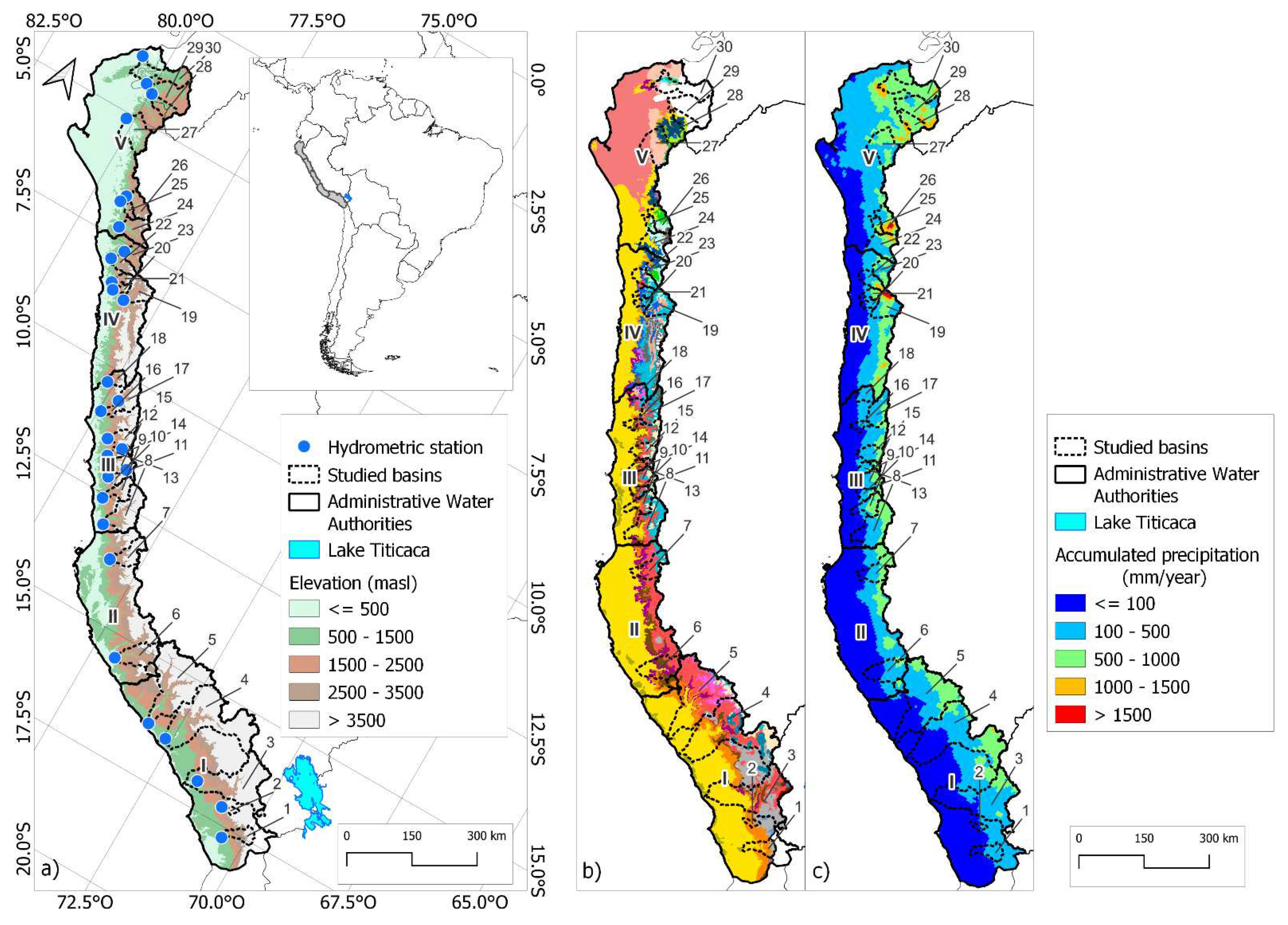
Figure 2.
Methodological diagram for the evaluation of precipitation products for streamflow generation in the Pd.
Figure 2.
Methodological diagram for the evaluation of precipitation products for streamflow generation in the Pd.
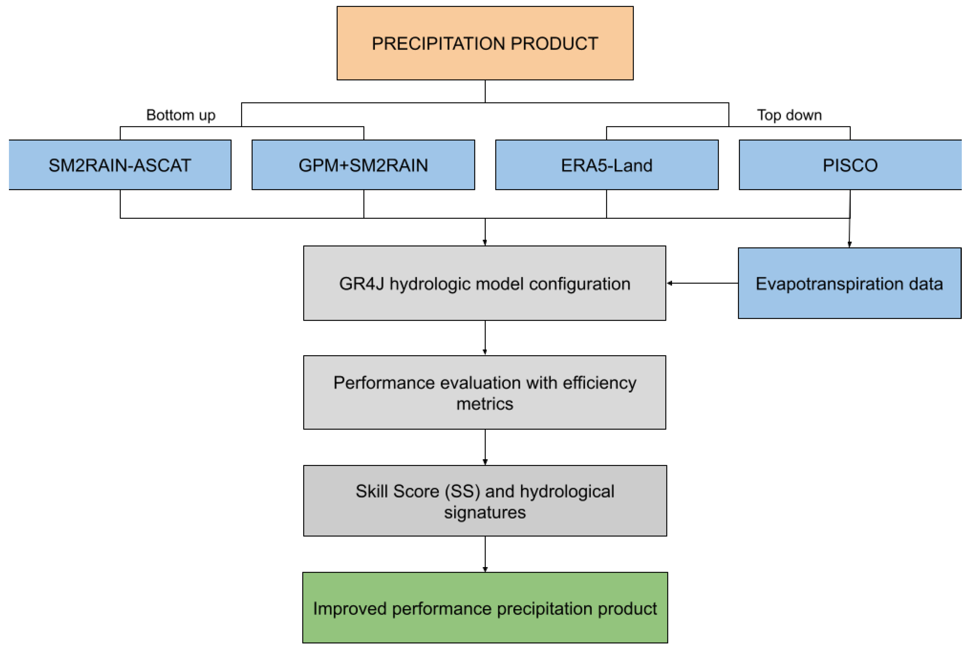
Figure 3.
Boxplot comparing efficiency metrics (NSE, KGE, BIAS and RMSE) between the calibration, validation, and total period phases of the hydrological modeling.
Figure 3.
Boxplot comparing efficiency metrics (NSE, KGE, BIAS and RMSE) between the calibration, validation, and total period phases of the hydrological modeling.
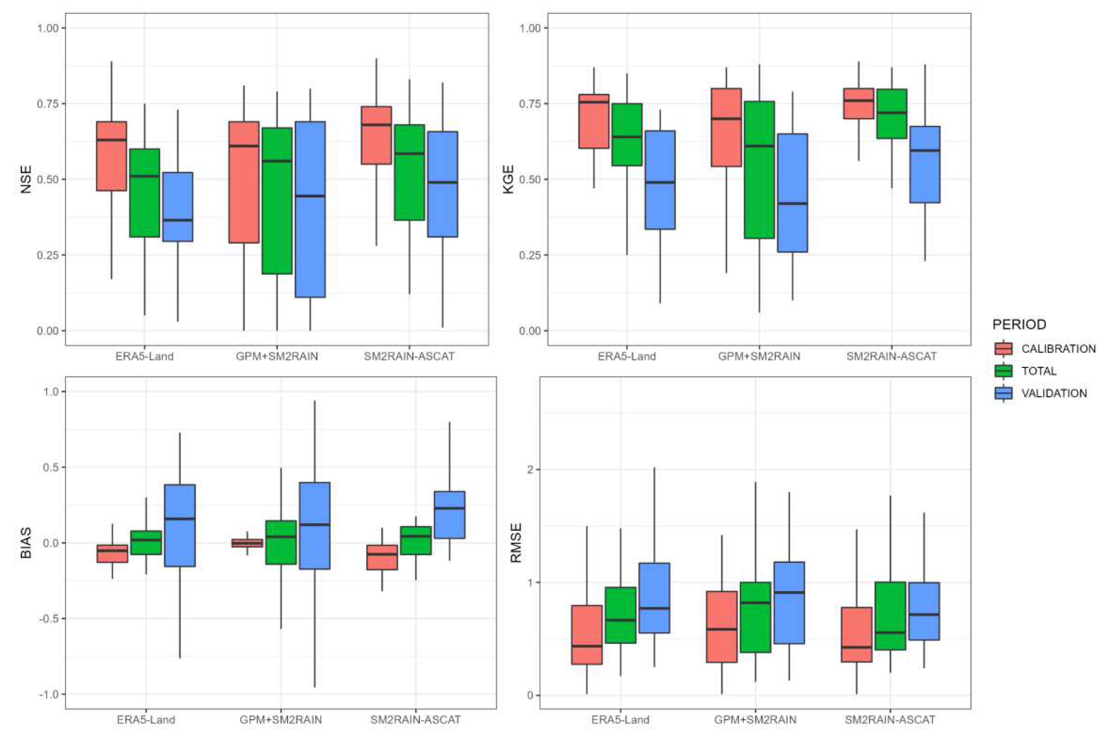
Figure 5.
Distribution of the efficiency metrics of the 30 basins in the calibration phase. (a) NSE; (b)KGE.
Figure 5.
Distribution of the efficiency metrics of the 30 basins in the calibration phase. (a) NSE; (b)KGE.
Figure 6.
Simulated daily streamflow during the calibration and validation stages by GR4J using the precipitation products SM2RAIN-ASCAT (purple line), ERA5-Land (blue line), and GPM+SM2RAIN (green line). The black dots represent the observed discharge. a) Region V: El Tigre; b) Region IV: Quirihuac; c) Region III: Obrajillo; d) Region II: Letrayoc; e) Region I: Ocoña.
Figure 7.
Performance scores for the KGE metric (X-axis) during the calibration stage. The histograms represent the performance of the precipitation products in relation to the size of the analyzed basins (Y-axis).
Figure 7.
Performance scores for the KGE metric (X-axis) during the calibration stage. The histograms represent the performance of the precipitation products in relation to the size of the analyzed basins (Y-axis).
Figure 8.
Results of the Skill Score (SS) for the SM2RAIN-ASCAT, ERA5-Land, and GPM+SM2RAIN SPPs compared to the simulated flows by PISCO, indicating the best product in each analyzed basin.
Figure 8.
Results of the Skill Score (SS) for the SM2RAIN-ASCAT, ERA5-Land, and GPM+SM2RAIN SPPs compared to the simulated flows by PISCO, indicating the best product in each analyzed basin.
Figure 9.
Hydrological signatures of the simulated streamflows by GR4J (ERA5-Land, GPM+SM2RAIN, and SM2RAIN-ASCAT, read from left to right). The left panel represents the capability of the precipitation product to represent each hydrological signature in terms of the correlation coefficient. The right panel represents the capability to represent the hydrological signature in each region, where dark blue indicates the best performance.
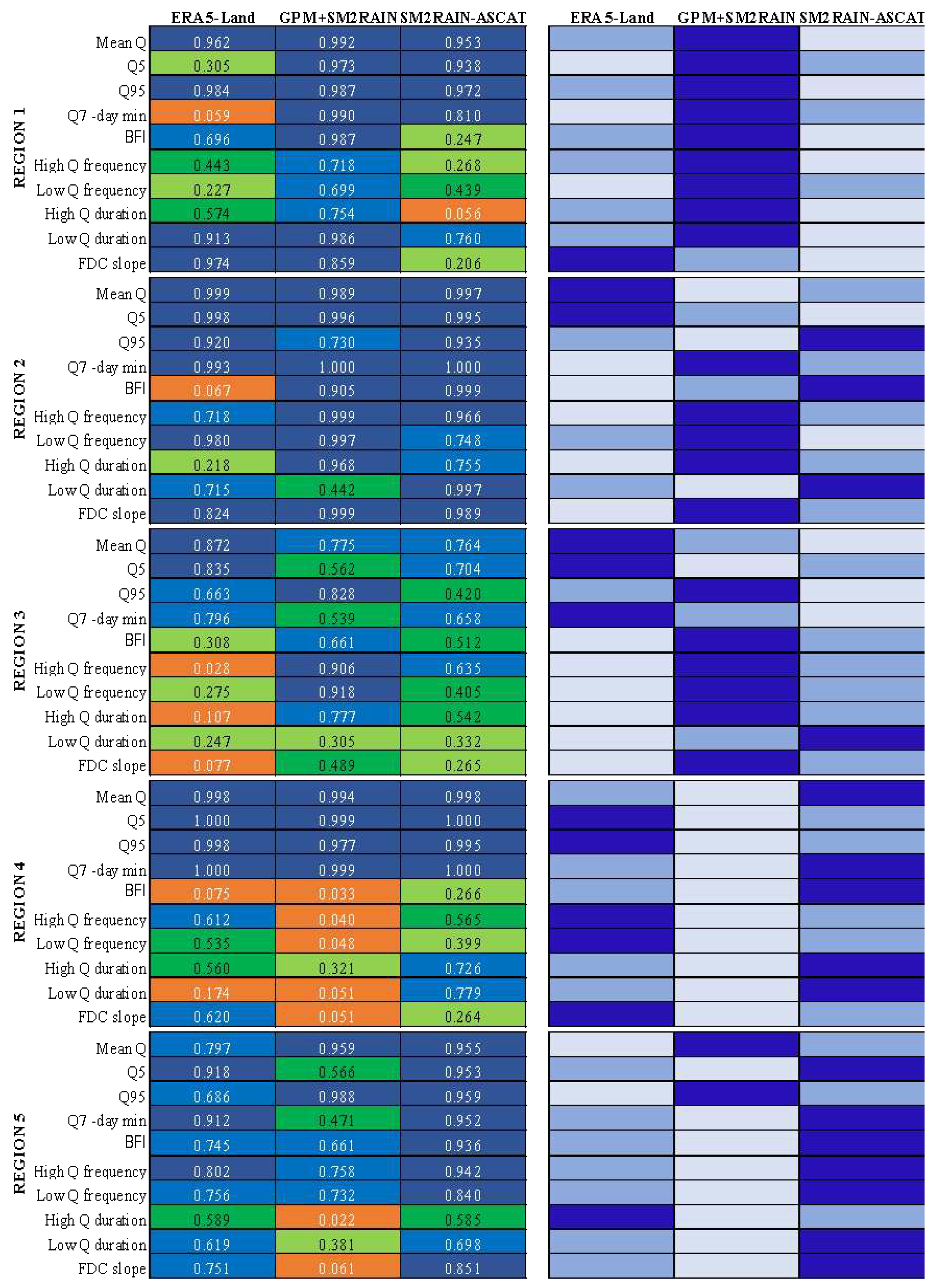

Table 1.
Distribution of the 30 basins in the Pacific drainage (Pd).
| Region (AAA) | ID | Hydrometric Station | Basin | Area (km2) |
|---|---|---|---|---|
| Region I: Caplina-Ocoña * |
1 | La Tranca | Sama | 1,937 |
| 2 | Tumilaca | Ilo-Moquegua | 462 | |
| 3 | La Pascana | Tambo | 13,020 | |
| 4 | Huatipa | Camaná | 16,937 | |
| 5 | Ocoña | Ocoña | 16,029 | |
| Region II: Chaparra-Chincha |
6 | Yauca | Yauca | 4,113 |
| 7 | Letrayoc | Pisco | 3,079 | |
| Region III: Cañete-Fortaleza |
8 | Socsi | Cañete | 5,786 |
| 9 | La Capilla | Mala | 2,145 | |
| 10 | Antapucro | Lurín | 996 | |
| 11 | Tamboraque | Rímac | 576 | |
| 12 | Chosica | Rímac | 2,305 | |
| 13 | Puente Magdalena | Chillón | 1,246 | |
| 14 | Obrajillo | Chillón | 365 | |
| 15 | Santo Domingo | Chancay-Huaral | 1,835 | |
| 16 | Las Minas | Supe | 766 | |
| 17 | Cahua | Pativilca | 2,949 | |
| 18 | Malvados | Chicama | 1,378 | |
| Region IV: Huarmey-Chicama |
19 | Condorcerro | Santa | 3,176 |
| 20 | Huamansaña | Huamansaña | 718 | |
| 21 | Huacapongo | Virú | 908 | |
| 22 | Quirihuac | Moche | 1,762 | |
| 23 | El Tambo | Tambo | 2,183 | |
| Region V: Jequetepeque-Zarumilla |
24 | Yonán | Jequetepeque | 3,298 |
| 25 | Batan | Zaña | 797 | |
| 26 | Raca Rumi | Chancay-Lambayeque | 2,362 | |
| 27 | Puente Ñacara | Piura | 4,495 | |
| 28 | Puente Internacional Macara | Chira | 1,851 | |
| 29 | Ciruelo | Chira | 6,979 | |
| 30 | El Tigre | Tumbes | 4,663 |
Table 2.
Initial values in the GR4J hydrological model [27].
Table 2.
Initial values in the GR4J hydrological model [27].
| Parameter | Unit | Description |
|---|---|---|
| R | m | Initial water level in the first reservoir |
| S | m | High of the second reservoir |
Table 3.
Parameters of the GR4J hydrological model [27].
Table 3.
Parameters of the GR4J hydrological model [27].
| Parameter | Unit | Description | Initial value |
|---|---|---|---|
| X1 | m | First reservoir capacity | 5.9 |
| X2 | m | Water interchange coefficient | 0.0 |
| X3 | m | Second reservoir capacity | 4.5 |
| X4 | dt | Base time of the unit hydrograph | 0.2 |
Table 4.
Statistical efficiency indicators [41].
Table 4.
Statistical efficiency indicators [41].
| Statistics | Equation | Ideal value |
|---|---|---|
| Nash Sutcliffe Efficiency | 1 | |
| Kling Gupta Efficiency | 1 | |
| Root Mean Square Error | 0 | |
| Relative Bias | 0 | |
| Pearson Correlation coefficient | 1 |
Table 5.
Referential values for efficiency metrics [42].
Table 5.
Referential values for efficiency metrics [42].
| Performance Rating | NSE | BIAS |
|---|---|---|
| Very Good | 0.75 - 1.00 | ≤ ±10 |
| Good | 0.65 - 0.75 | ±10 - ±15 |
| Satisfactory | 0.50 - 0.65 | ±15 - ±25 |
| Unsatisfactory | < 0.50 | ≥ ±25 |
Table 6.
Hydrological signatures considered in this study [14].
Table 6.
Hydrological signatures considered in this study [14].
| Attribute | Long name | Unit |
|---|---|---|
| Mean Q | Mean daily streamflow | mm.day-1 |
| Q5 | Streamflow 5th quantile | mm.day-1 |
| Q95 | Streamflow 95th quantile | mm.day-1 |
| Q7-day min | 7-day minimum streamflow | - |
| High Q frequency | Max streamflow frequency | y-1 |
| High Q duration | Max streamflow duration Min streamflow frequency | days |
| Low Q frequency | Min streamflow duration | y-1 |
| Low Q duration | Mean daily streamflow | days |
| BFI | Baseflow index | - |
| FDC slope | The slope of the flow duration curve | - |
Disclaimer/Publisher’s Note: The statements, opinions and data contained in all publications are solely those of the individual author(s) and contributor(s) and not of MDPI and/or the editor(s). MDPI and/or the editor(s) disclaim responsibility for any injury to people or property resulting from any ideas, methods, instructions or products referred to in the content. |
© 2023 by the authors. Licensee MDPI, Basel, Switzerland. This article is an open access article distributed under the terms and conditions of the Creative Commons Attribution (CC BY) license (http://creativecommons.org/licenses/by/4.0/).
Copyright: This open access article is published under a Creative Commons CC BY 4.0 license, which permit the free download, distribution, and reuse, provided that the author and preprint are cited in any reuse.


