Submitted:
02 November 2023
Posted:
03 November 2023
You are already at the latest version
Abstract
Keywords:
1. Introduction
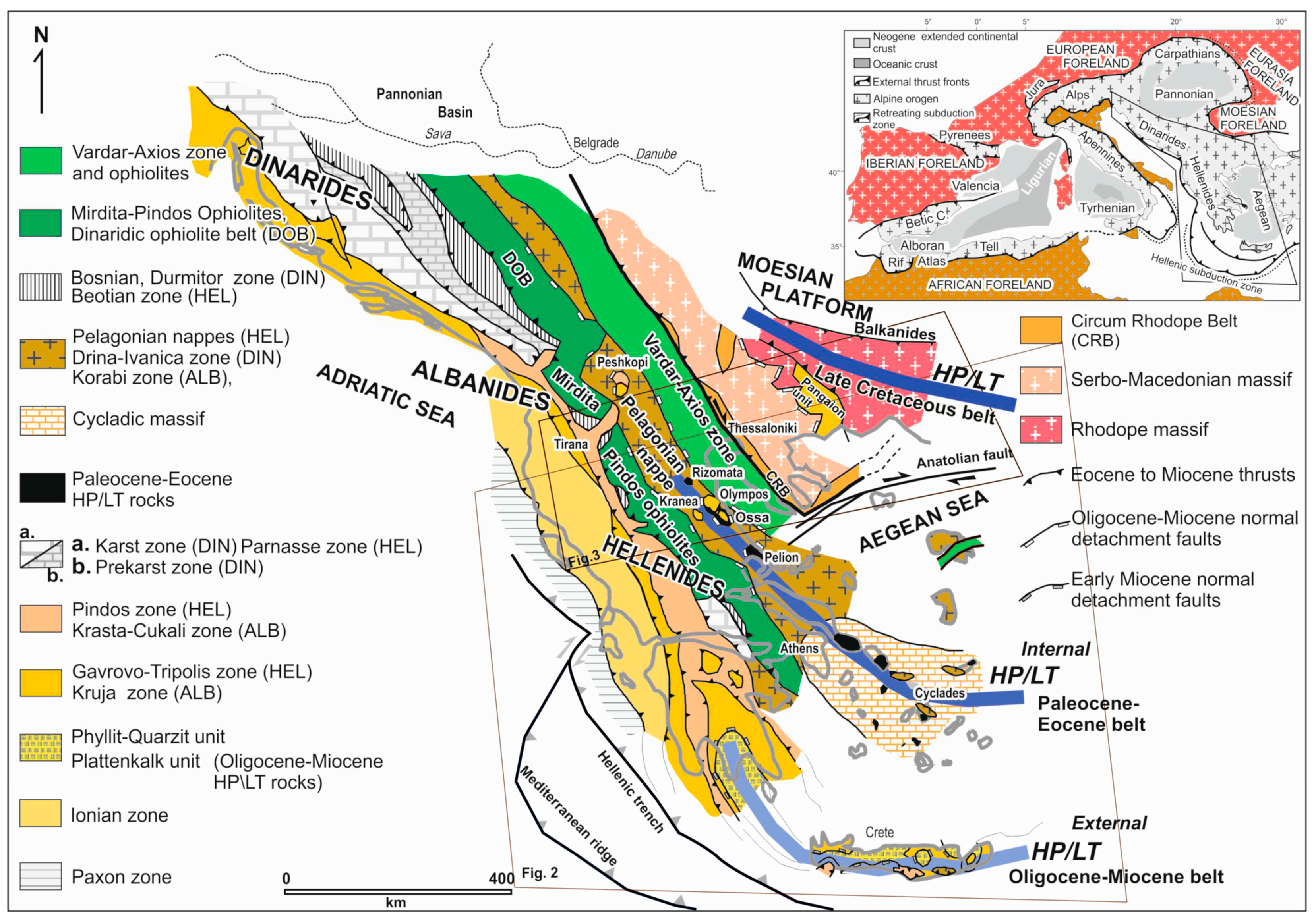
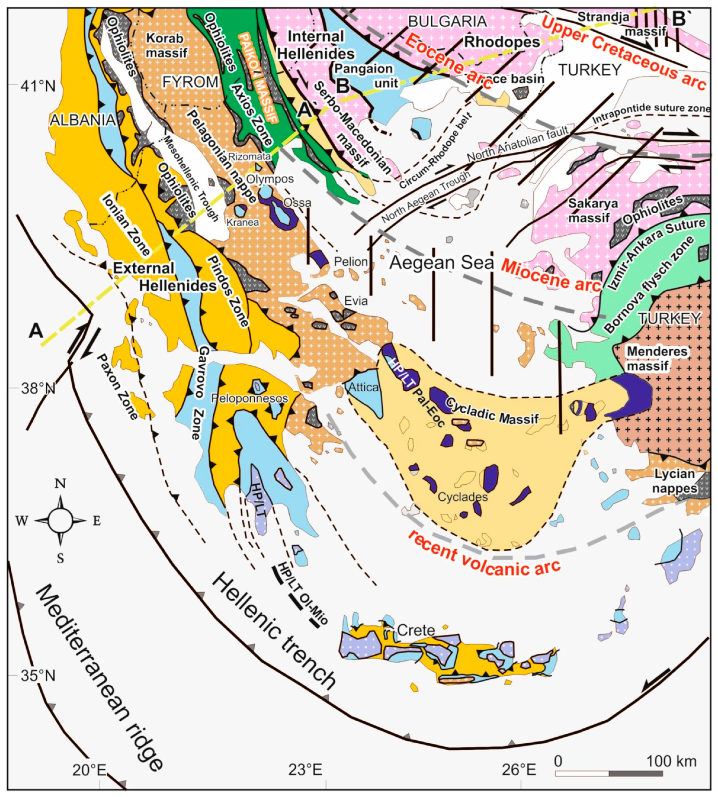
2. Geological Setting
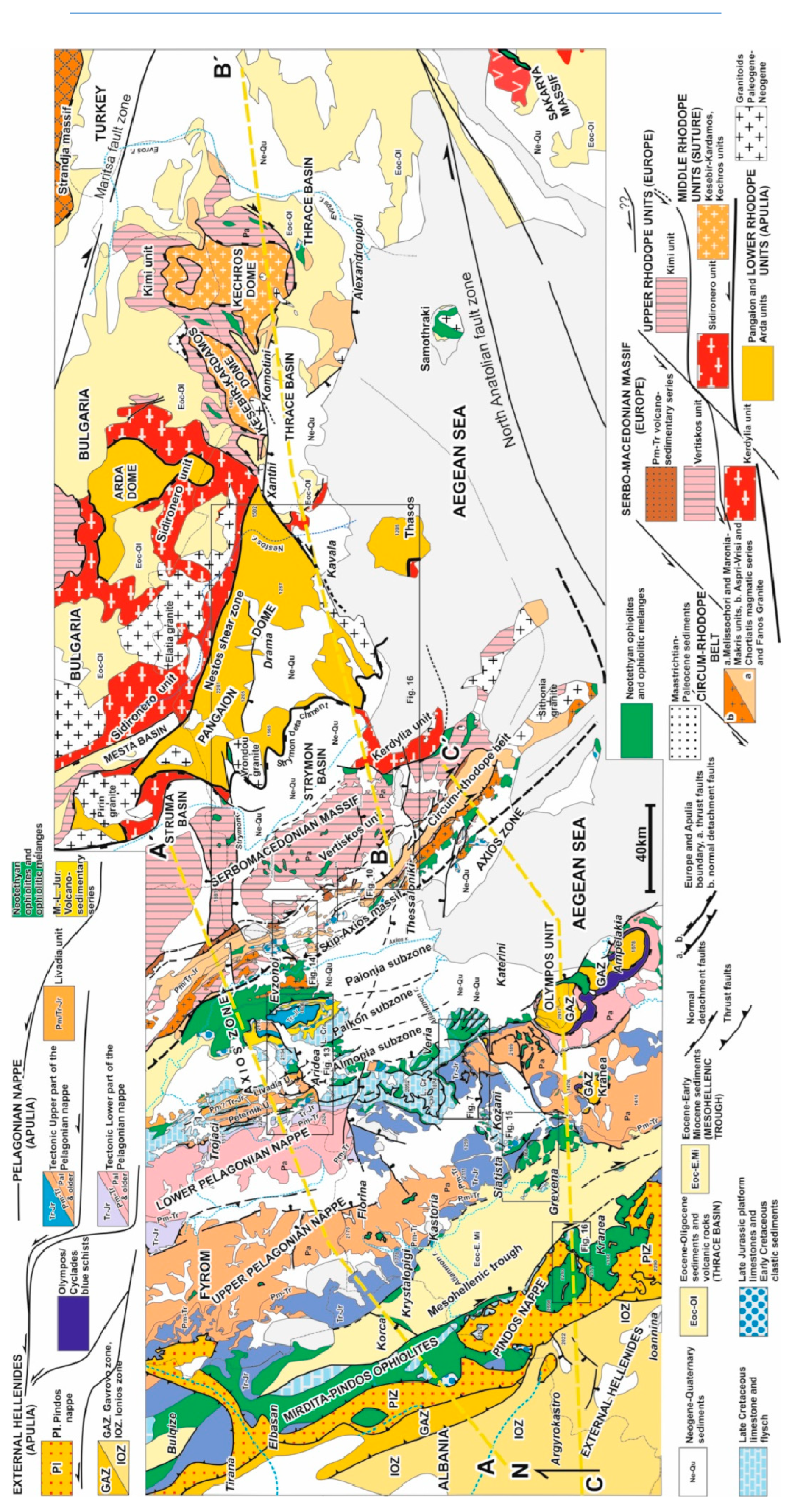
2.1. External Hellenides
2.1.1. Paxon Zone
2.1.2. Ionian Zone
2.1.3. Gavrovo Zone
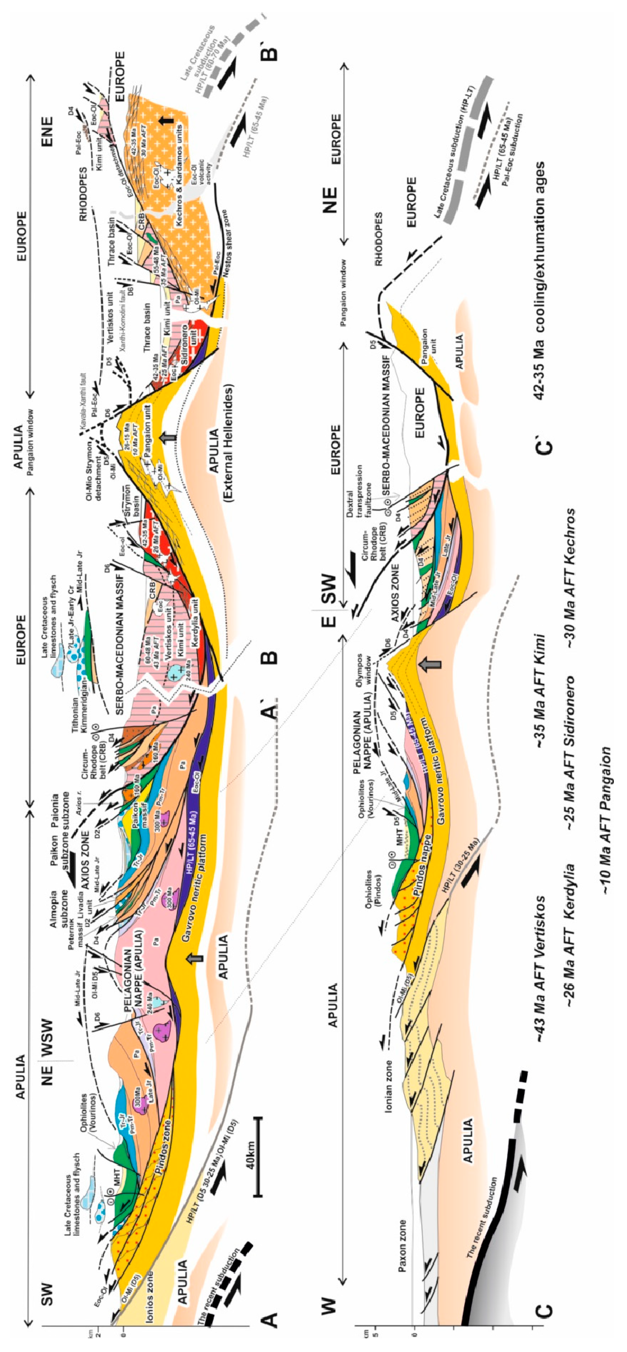
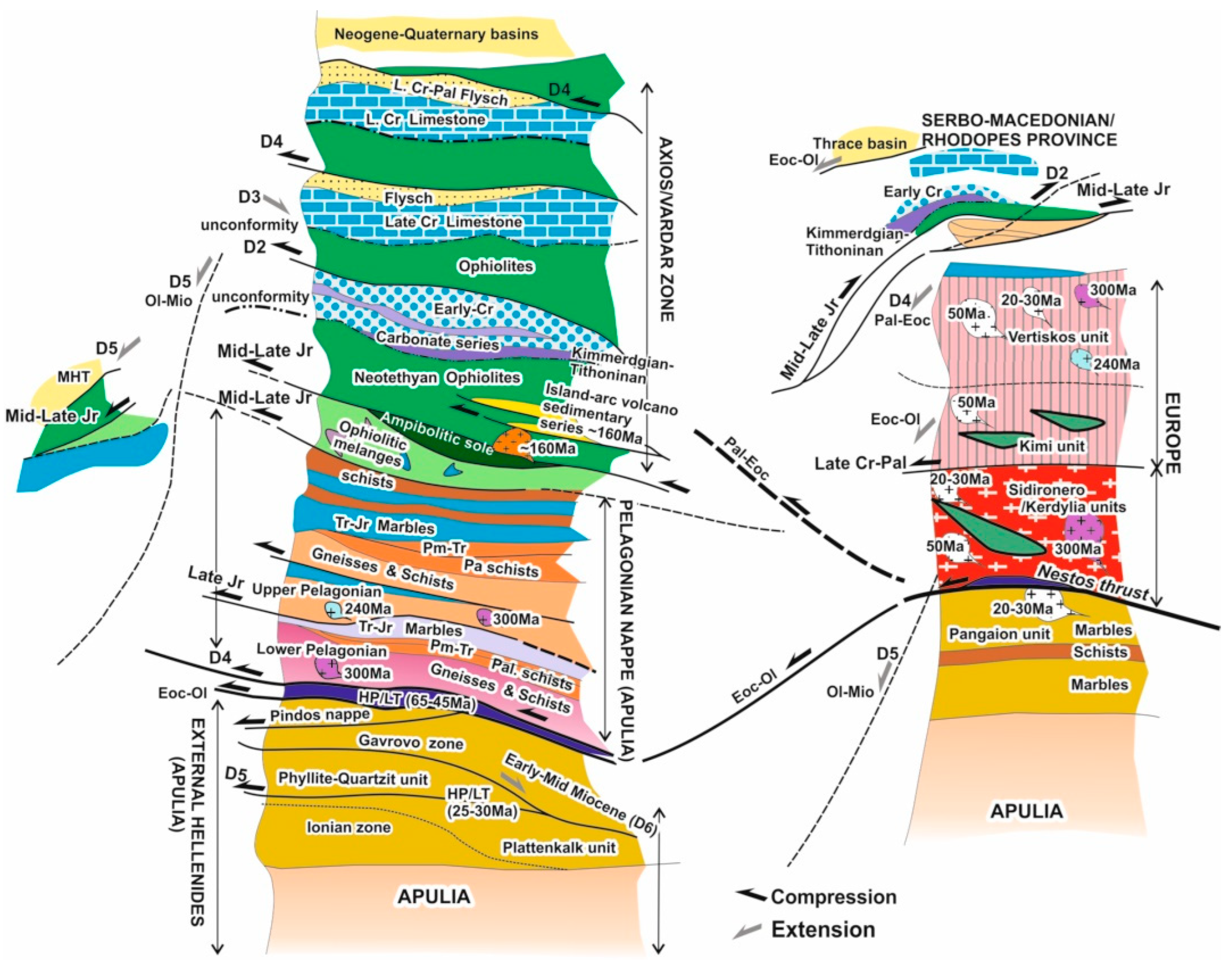
2.1.3. Pindos Zone
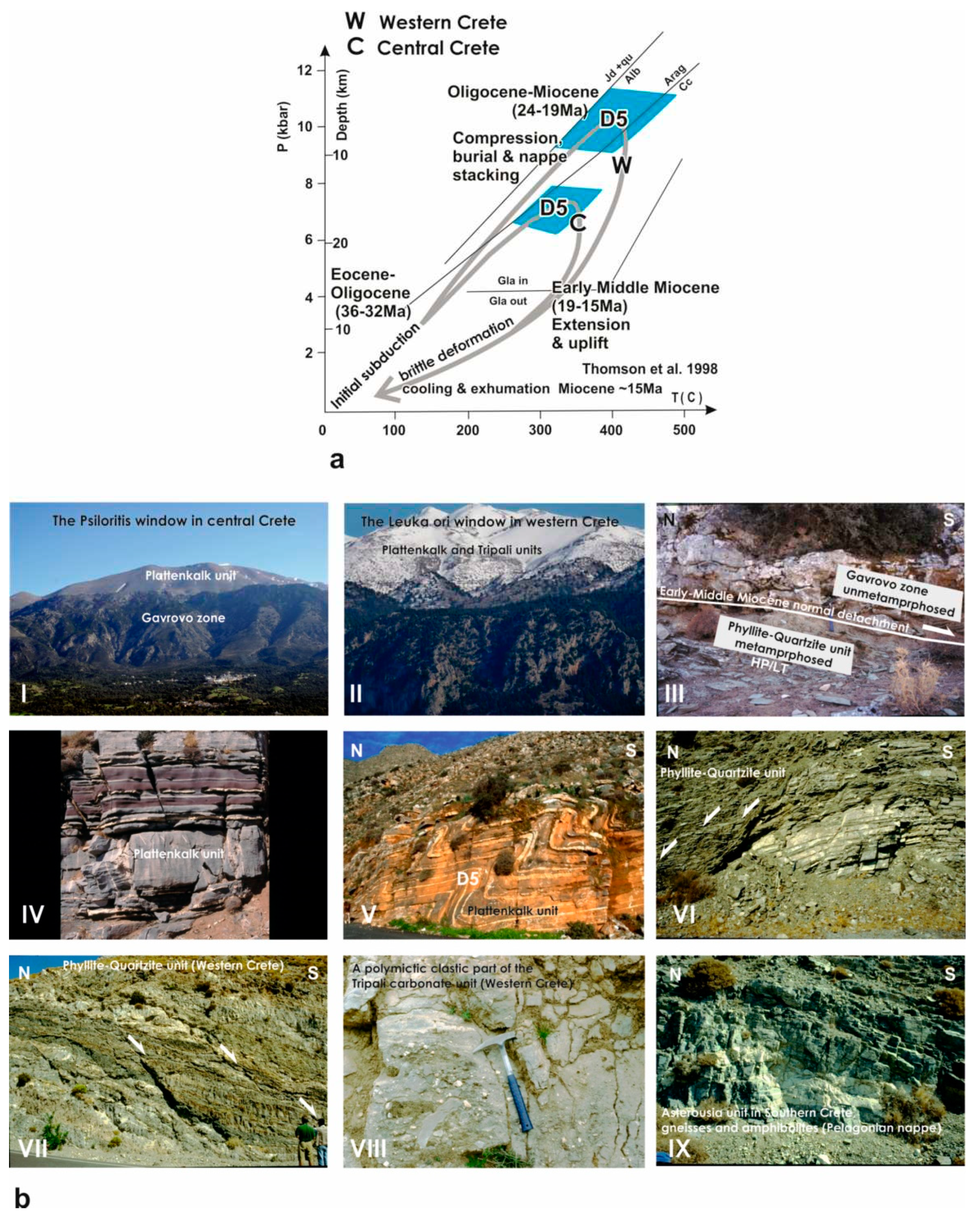

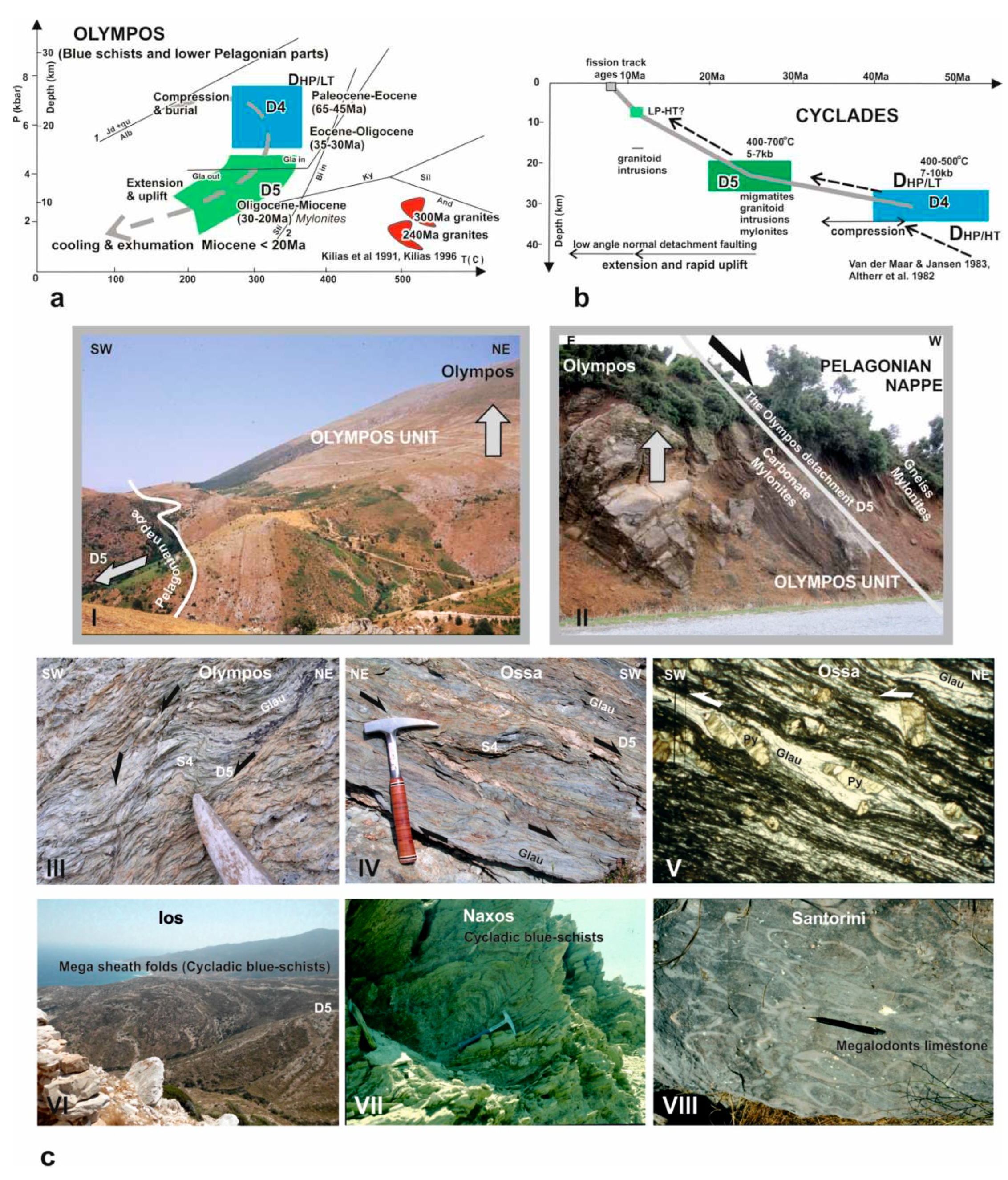
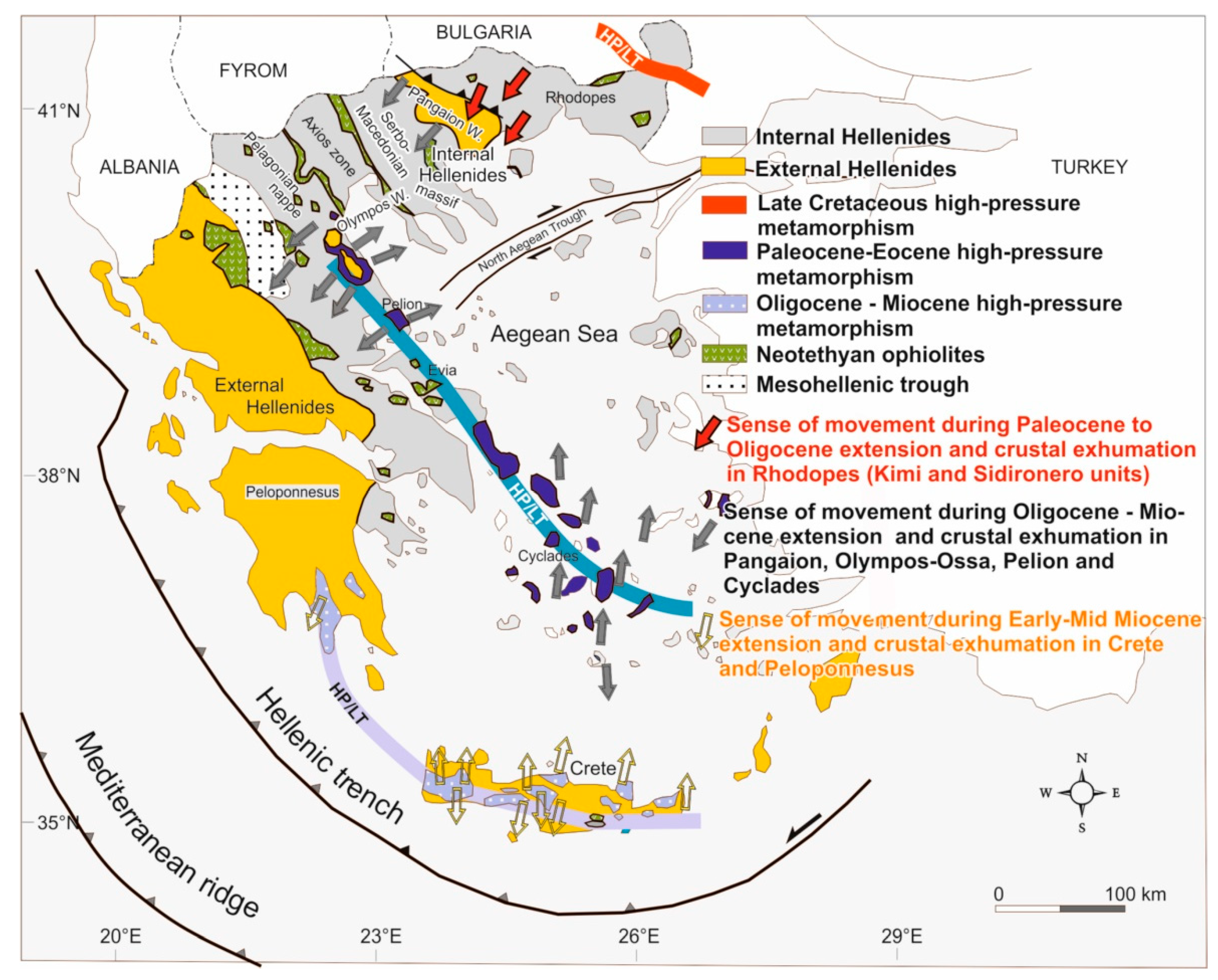
2.2. Internal Hellenides
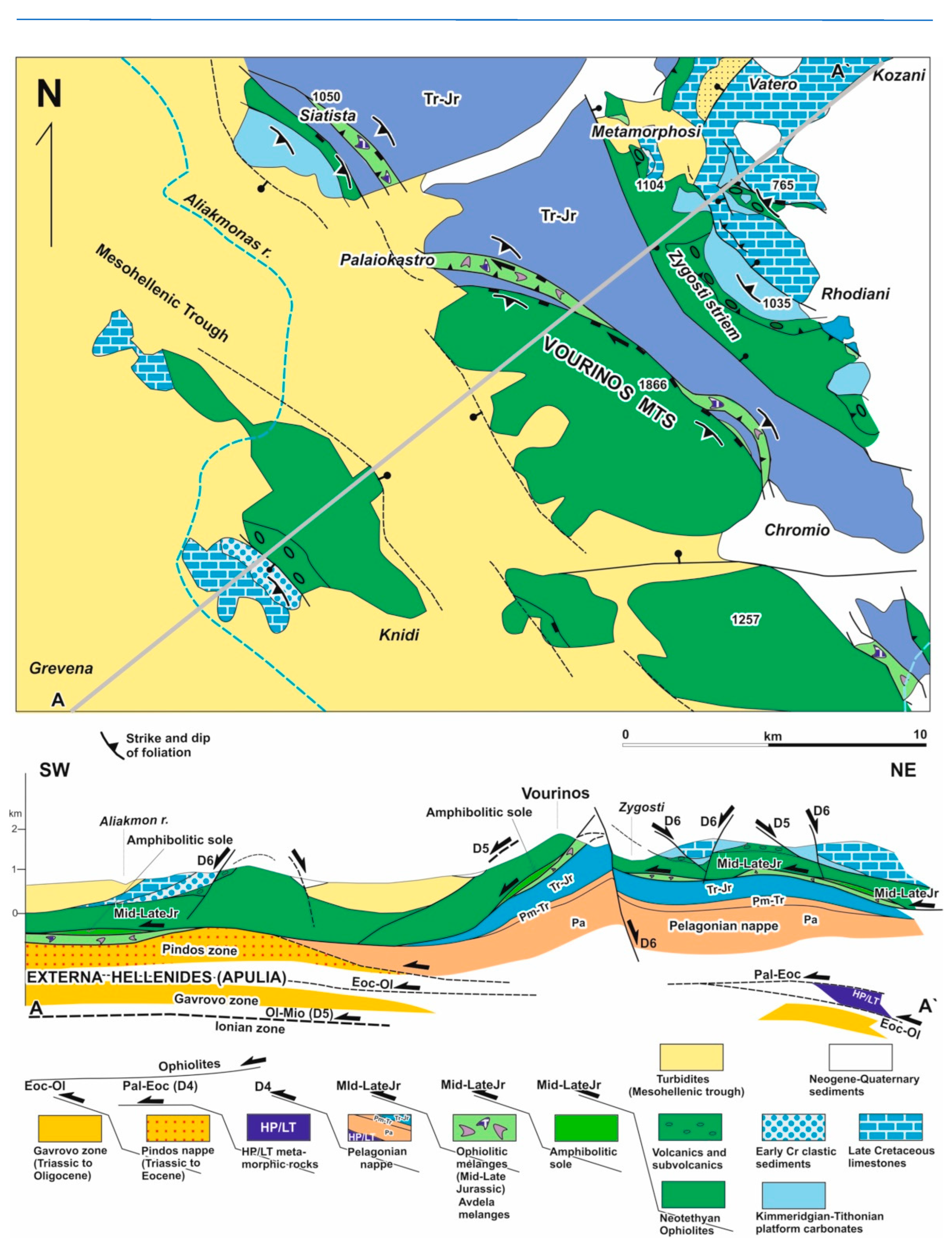
2.2.1. Pelagonian Zone or Nappe
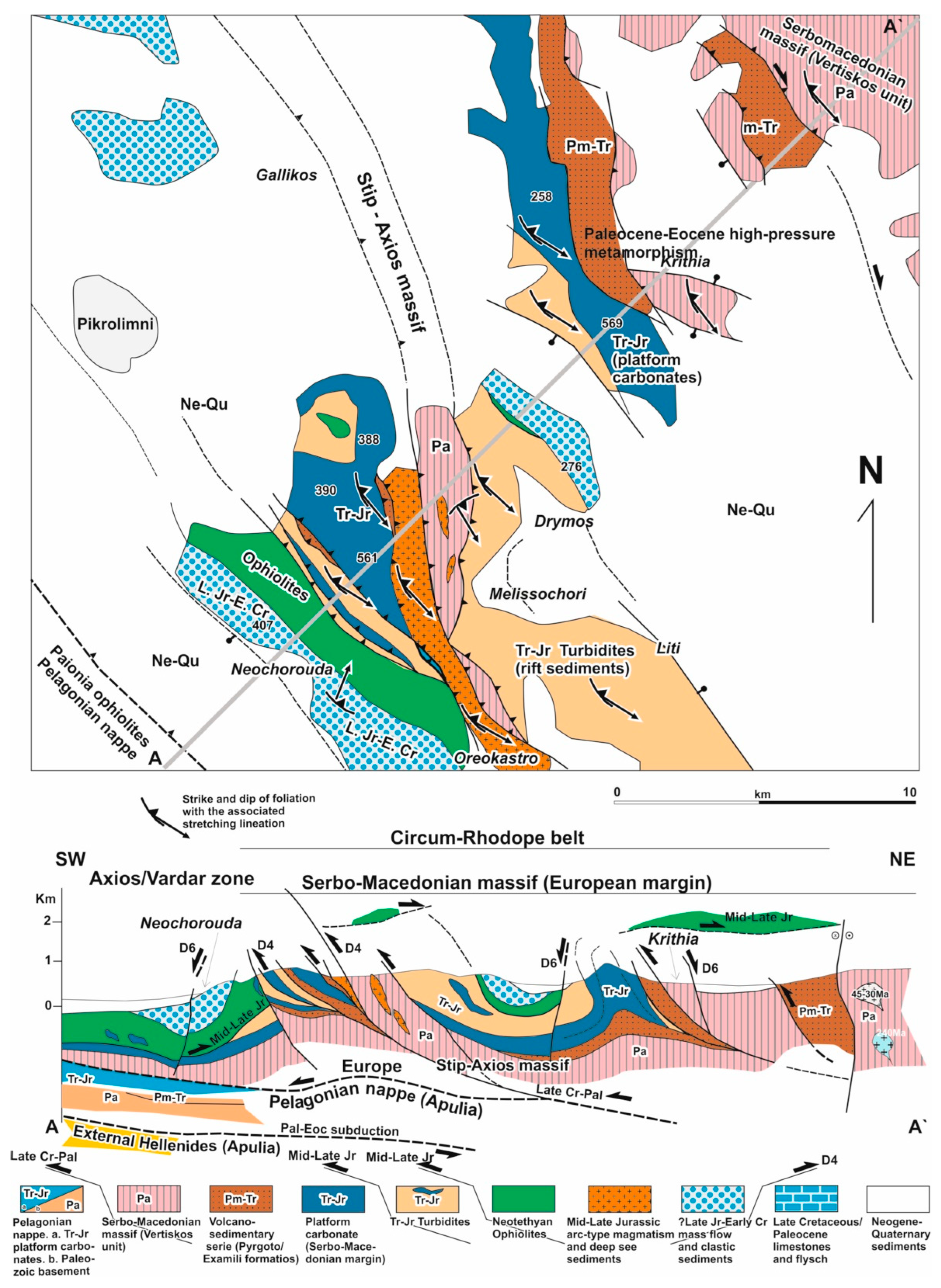
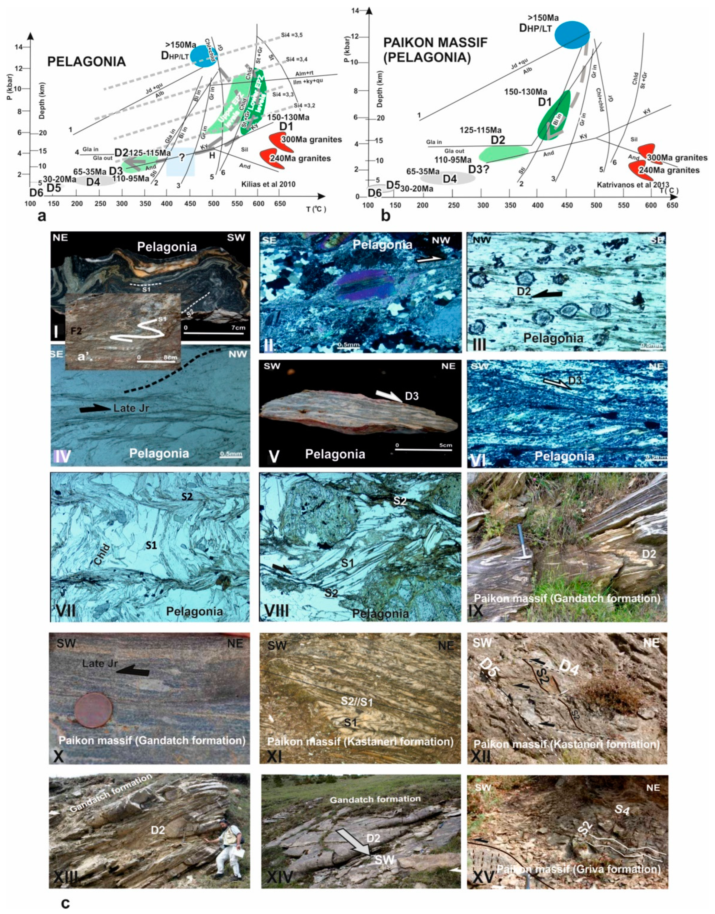
2.2.2. Axios/Vardar Zone
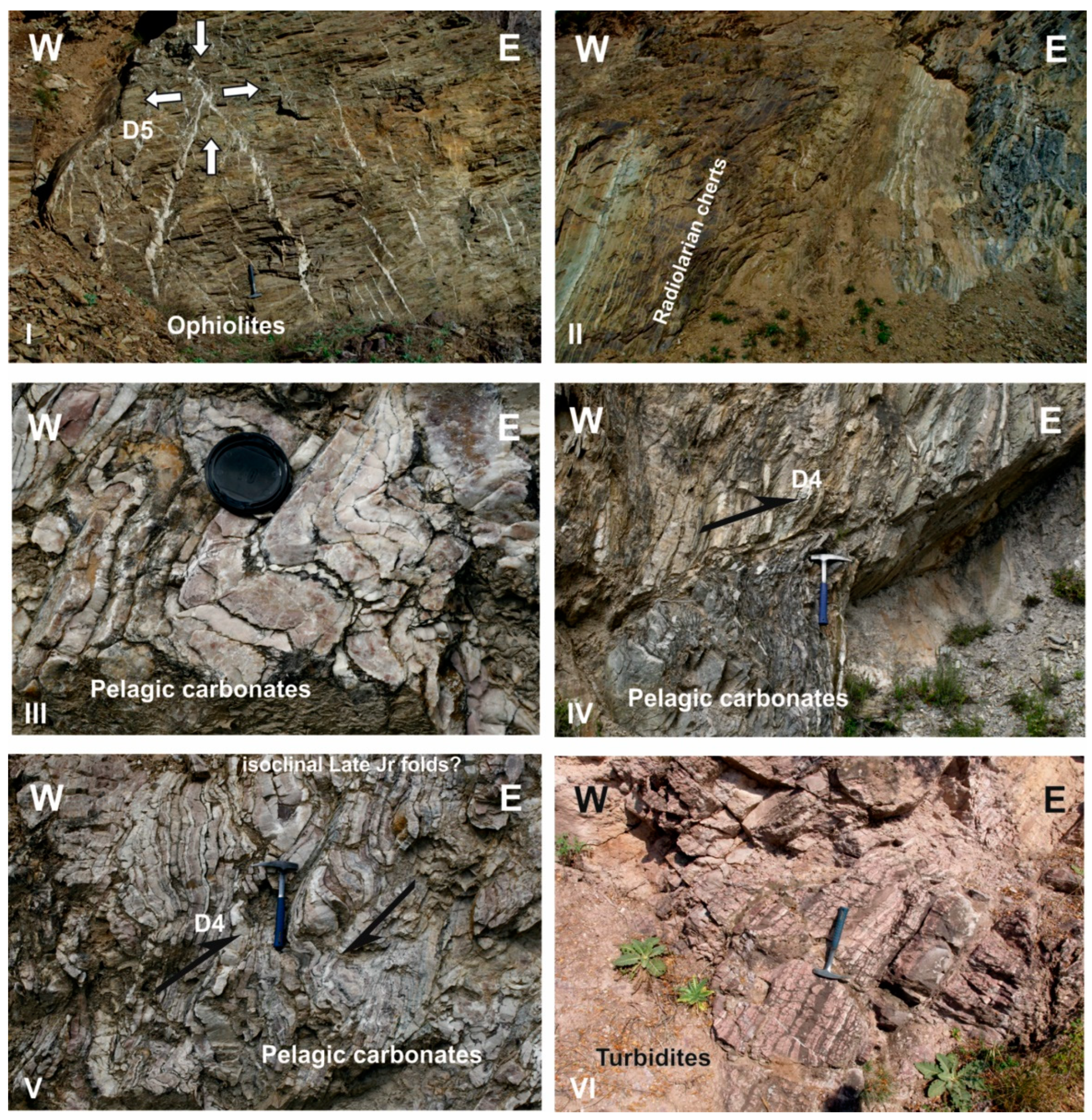
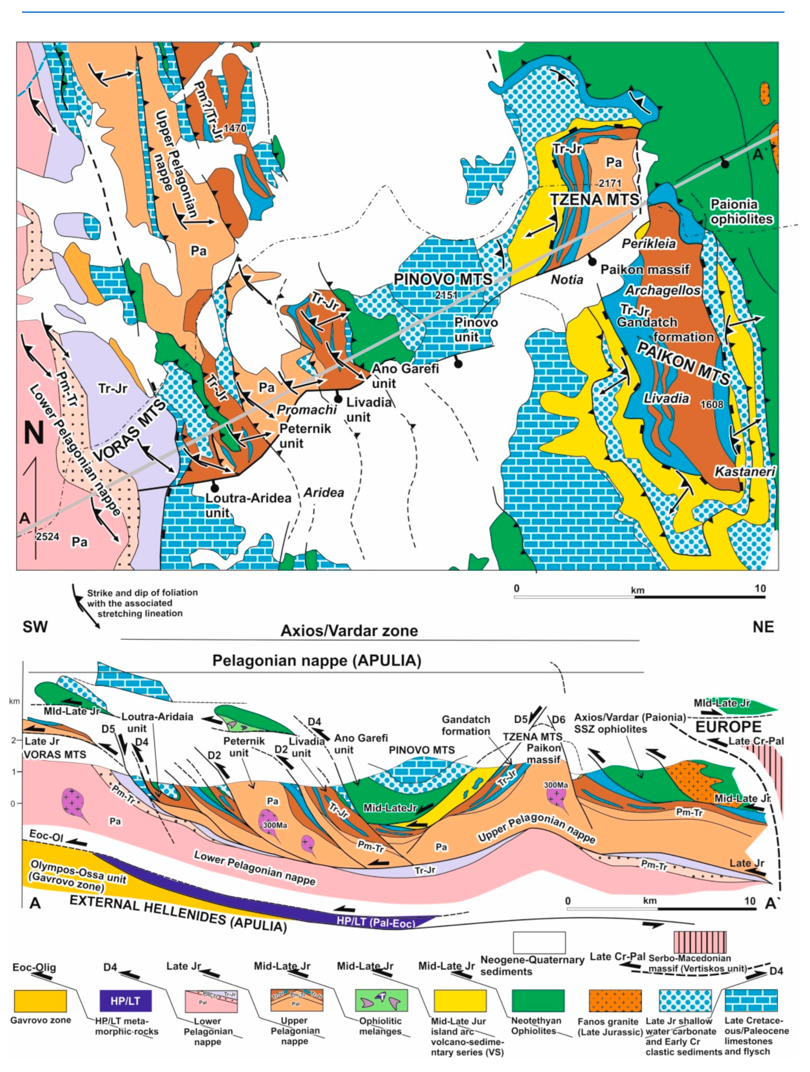
2.2.3. Cycladic massif
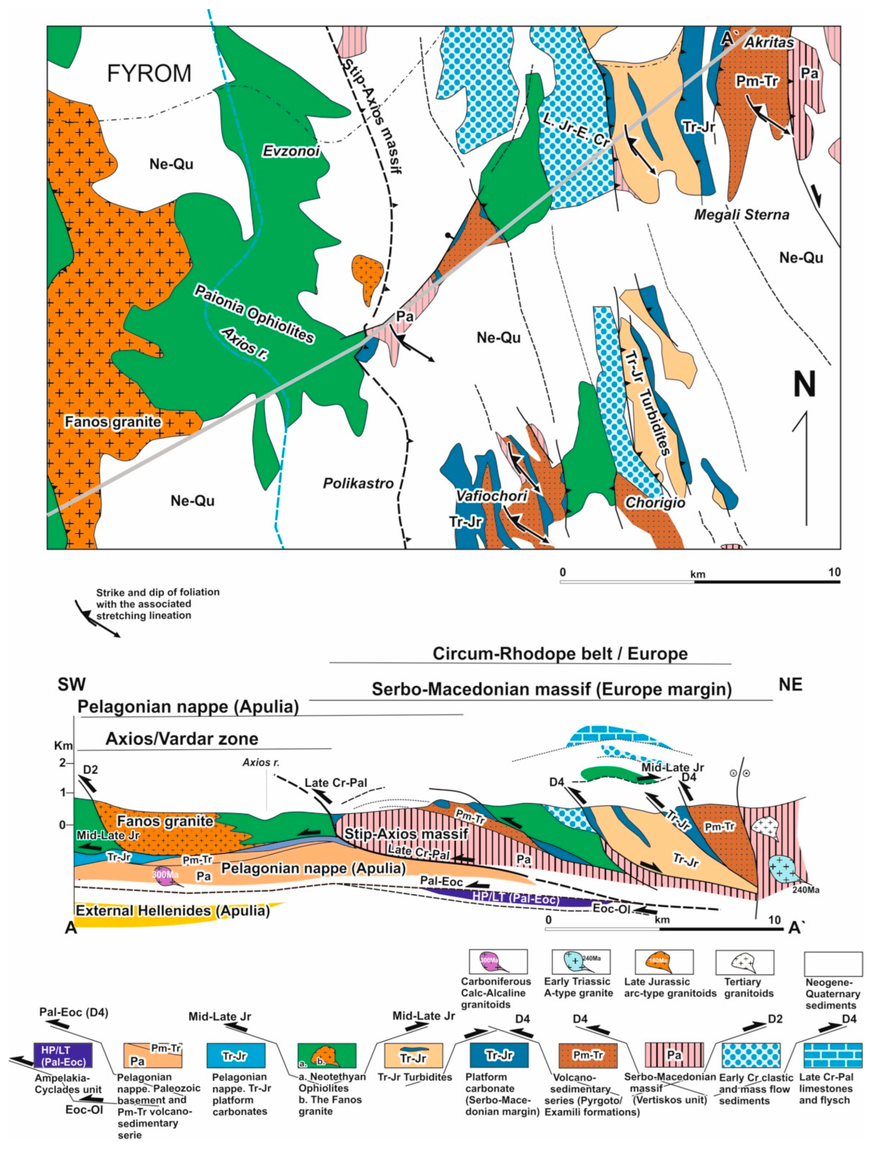
2.2.4. Serbo-Macedonian and Rhodope metamorphic massifs
2.2.4.1. Rhodope massif
- I. Pangaion unit
- II. Sidironero unit
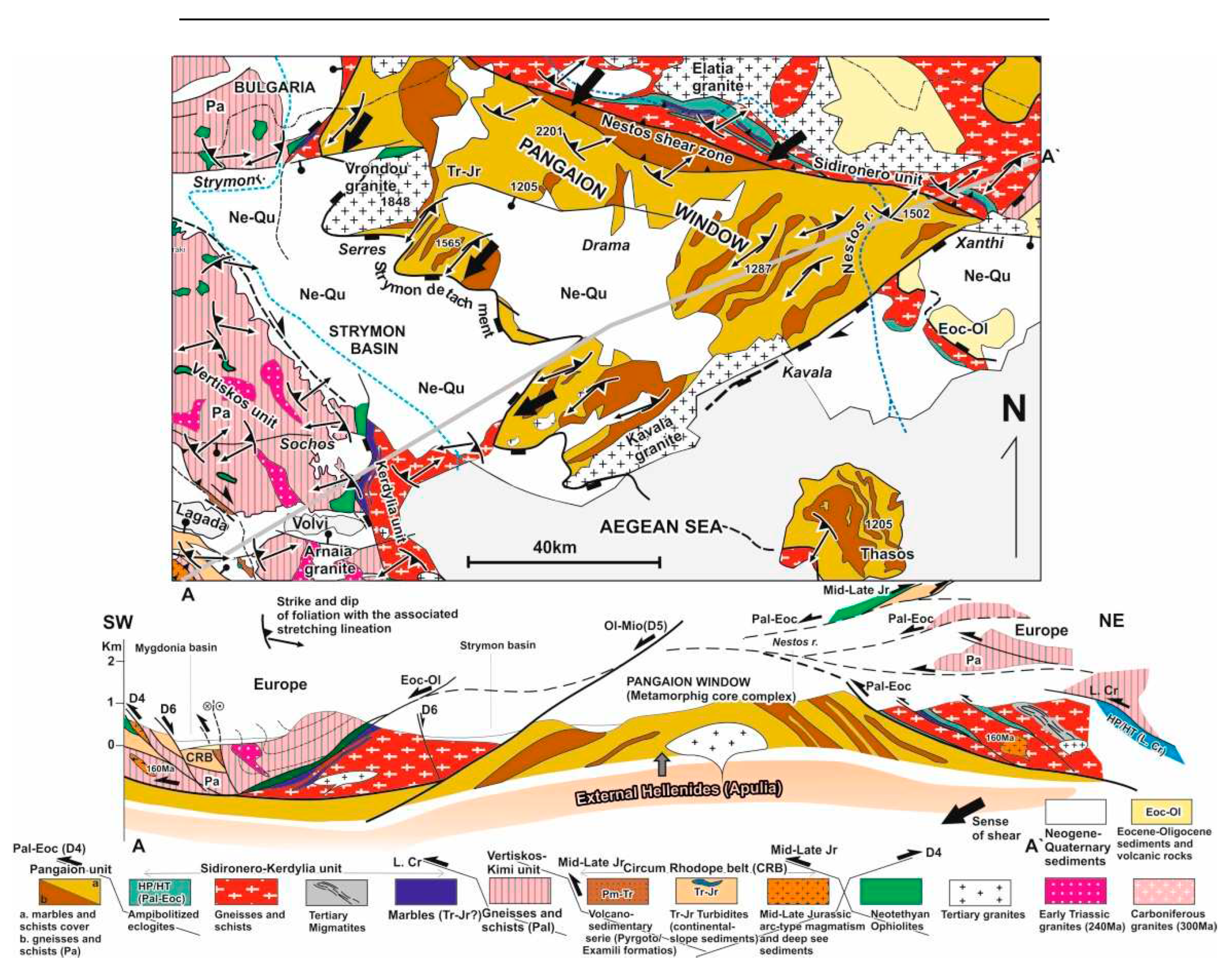
- III. Kimi unit
2.2.4.2. Serbo-Macedonian massif
- I. Kerdylia unit
- II. Vertiskos unit
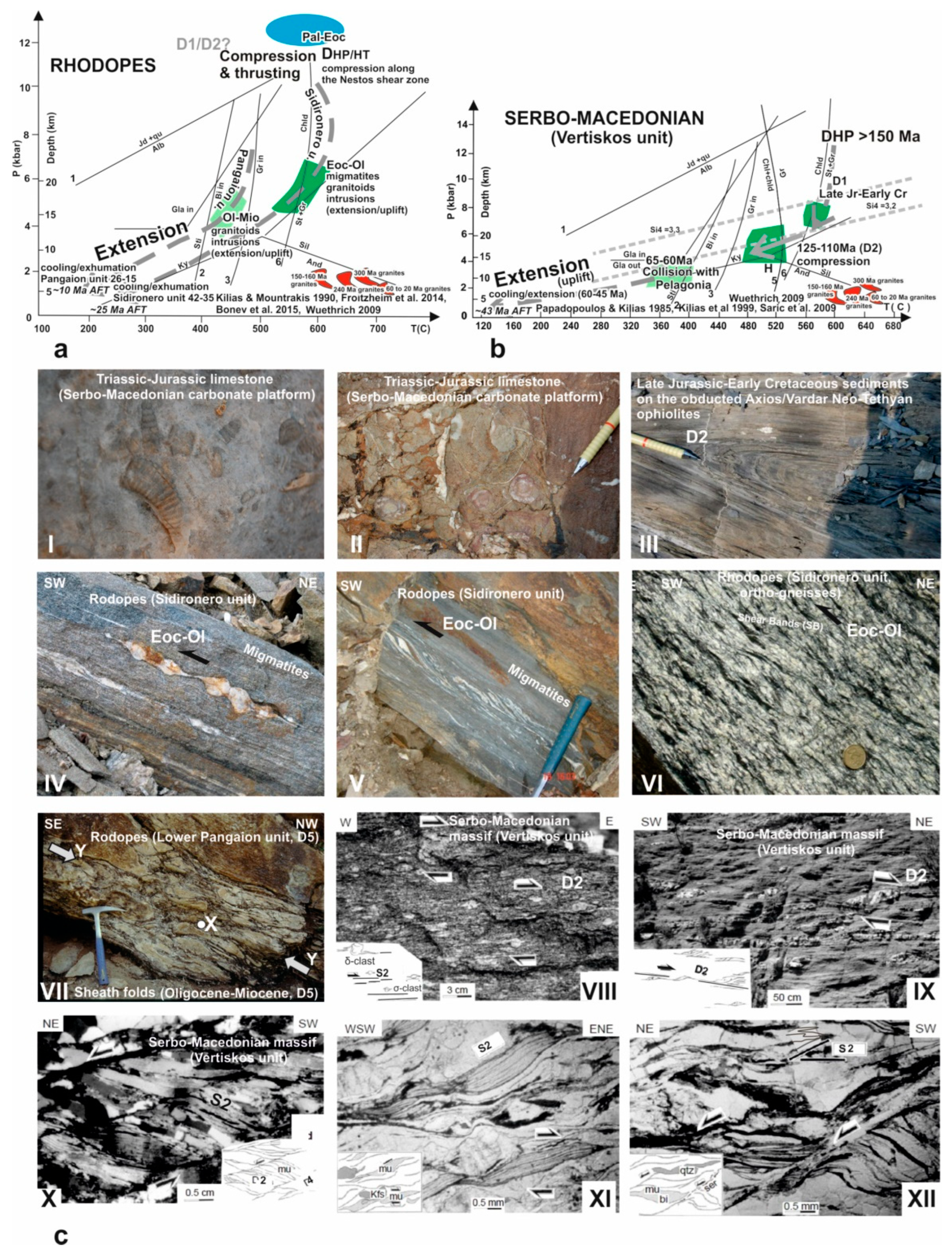
3. Alpine magmatic and depositional processes
3.1. Hercynian to Neogene-Quaternary magmatism
3.2. Sedimentary processes
3.2.1. Triassic-Jurassic sediments
3.2.2. The Mid-Late Jurassic ophiolitic mélanges

3.2.3. The Late Jurassic sedimentary series
3.2.4. The ?late Late Jurassic-Early Cretaceous mass flow and clastic sedimentary series
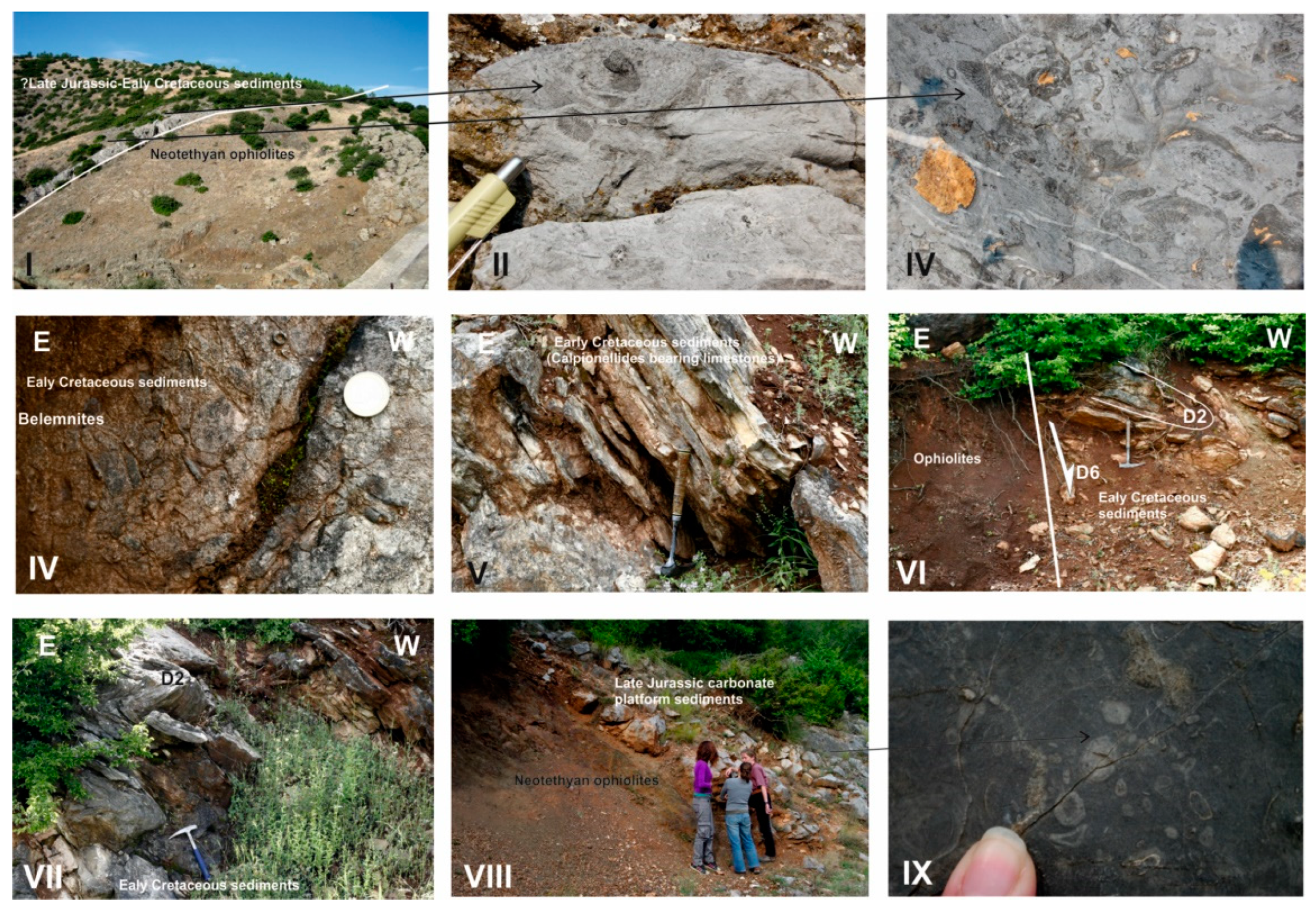
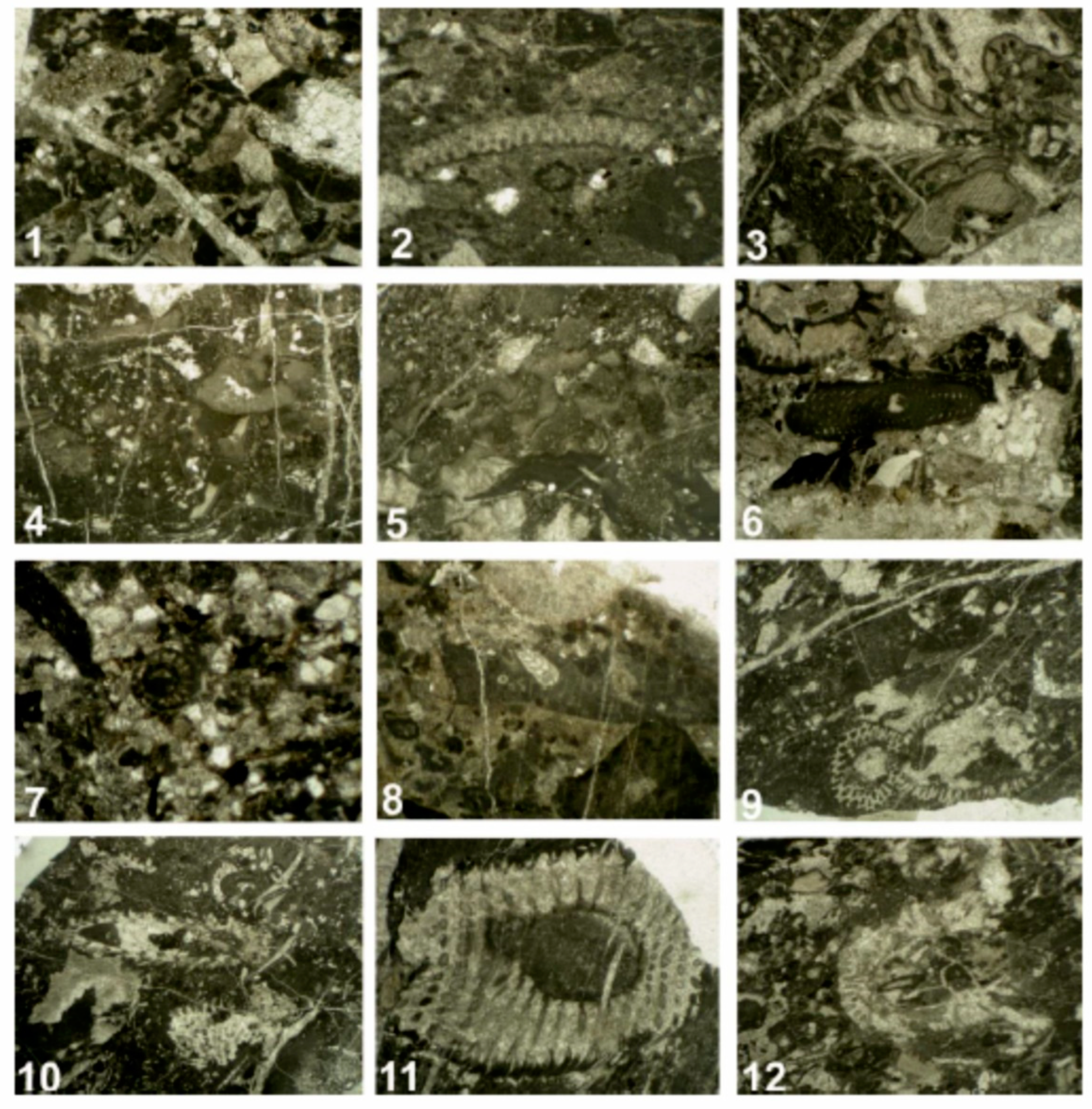
3.2.5. The Late Cretaceous shallow-water carbonate formation
3.2.6. The External Hellenides flysch series and the turbiditic deposits of the Meso-Hellenic trough and the Thrace basin. The post-orogenic Neogene-Quaternary sediments.
4. Architecture and kinematics of deformation and the related metamorphic conditions
4.1. Late Jurassic-Early Cretaceous deformational event (D1) and associated pre-Late Jurassic Alpine structural processes (~180 to 130 Ma)
4.2. Late Early Cretaceous deformational event (D2; ~125-115 Ma)
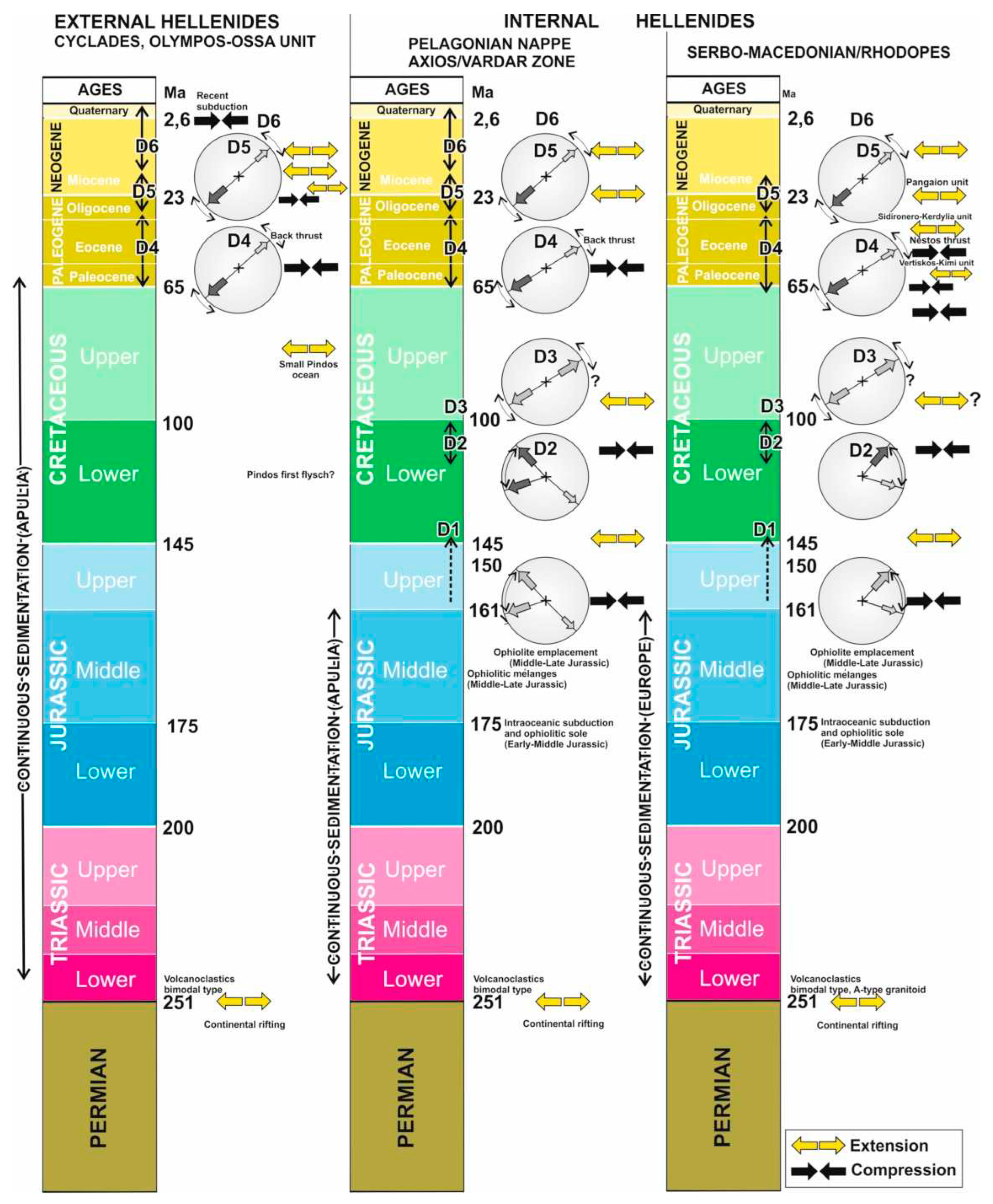
4.3. Late Early Cretaceous-Late Cretaceous deformational event (D3; ~110-80 Ma)
4.4. Early Paleocene to Early Oligocene deformational event (D4; ~65-30 Ma)
4.5. Oligocene-Miocene deformational event (D5; ~30Ma-20 Ma)

4.6. Neogene-Quarternary deformational event (D6; ~20 Ma to recent)
5. Geotectonic reconstruction of the Hellenides and Discussion
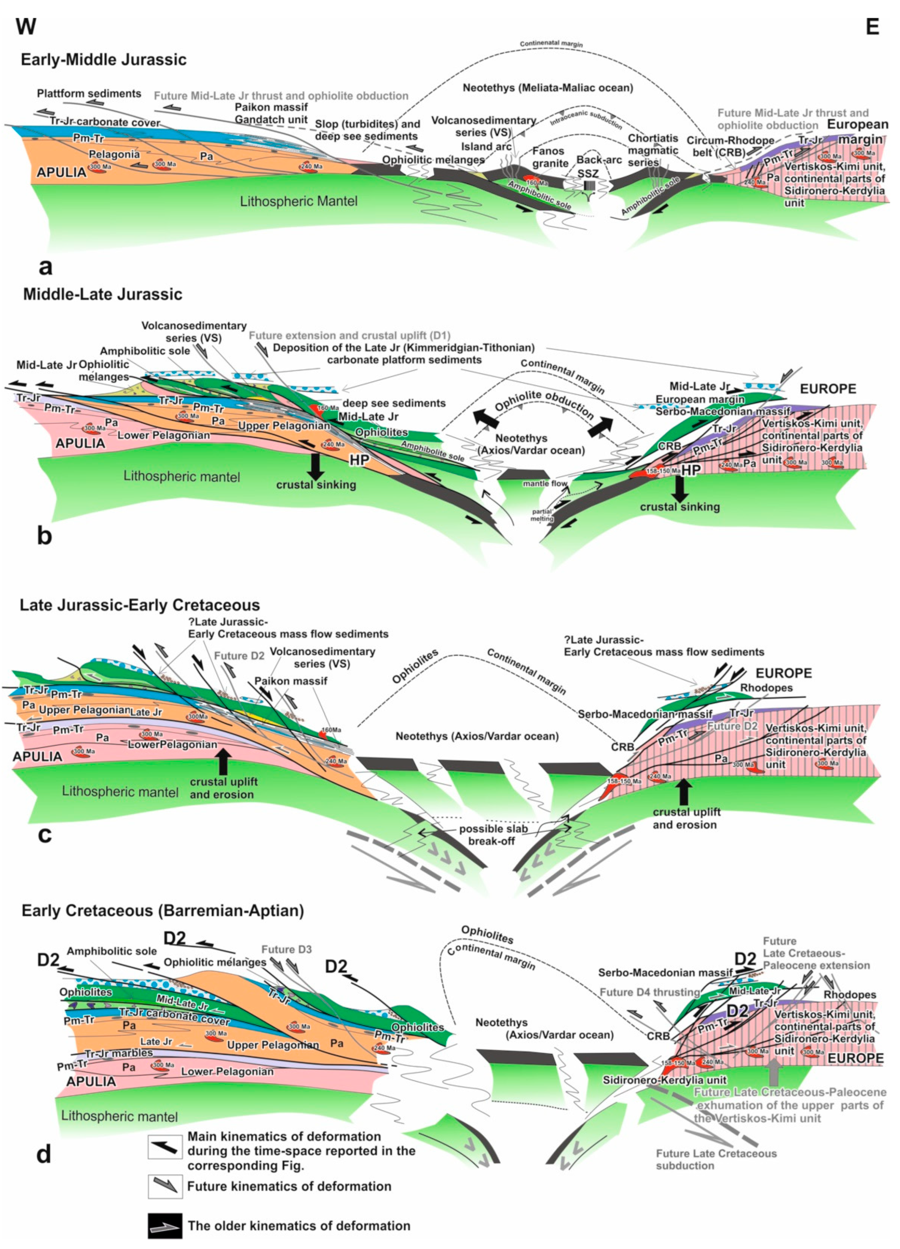
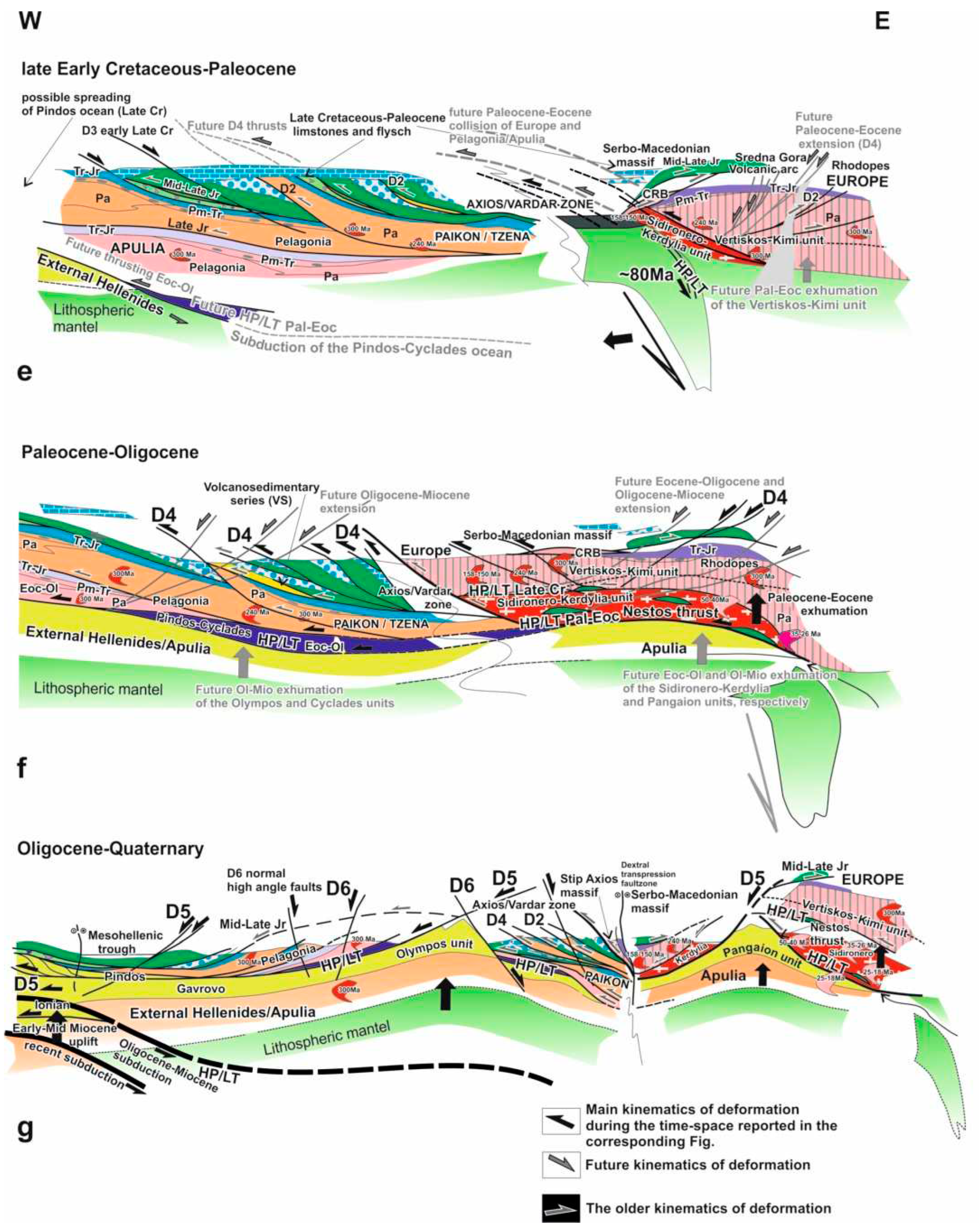
6. Conclusions
- I.
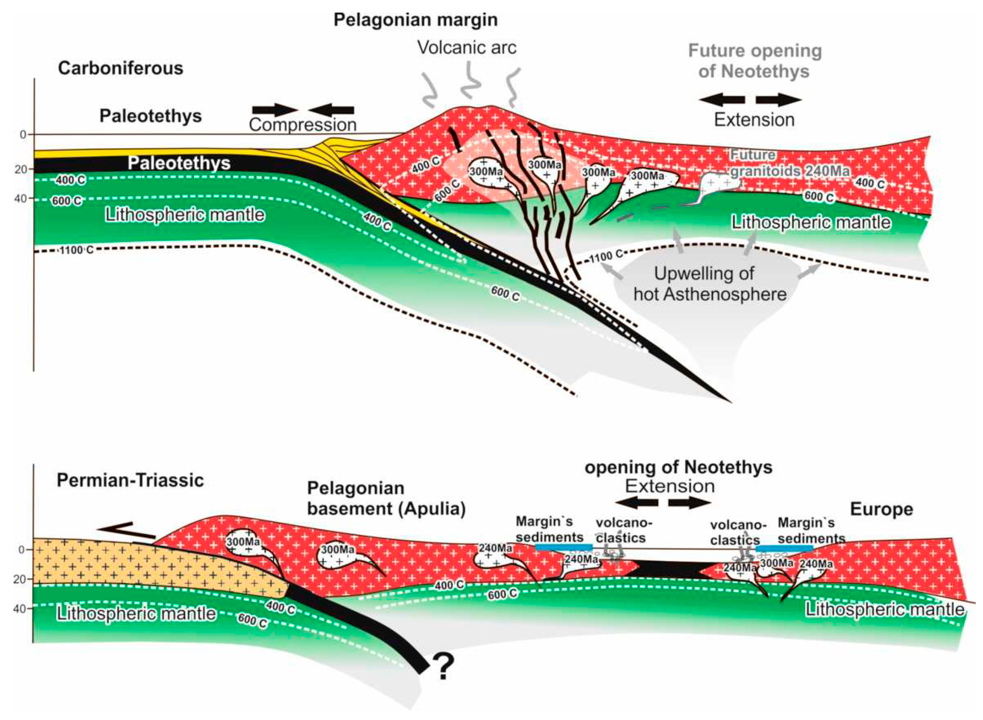
- The Alpine structural evolution of the Hellenides starts during the Permo-Triassic with the continental rifting of the Pangea super-continent and the progressive opening of the Neotethyan Meliata/Maliac-Axios/Vardar ocean realm
- II.
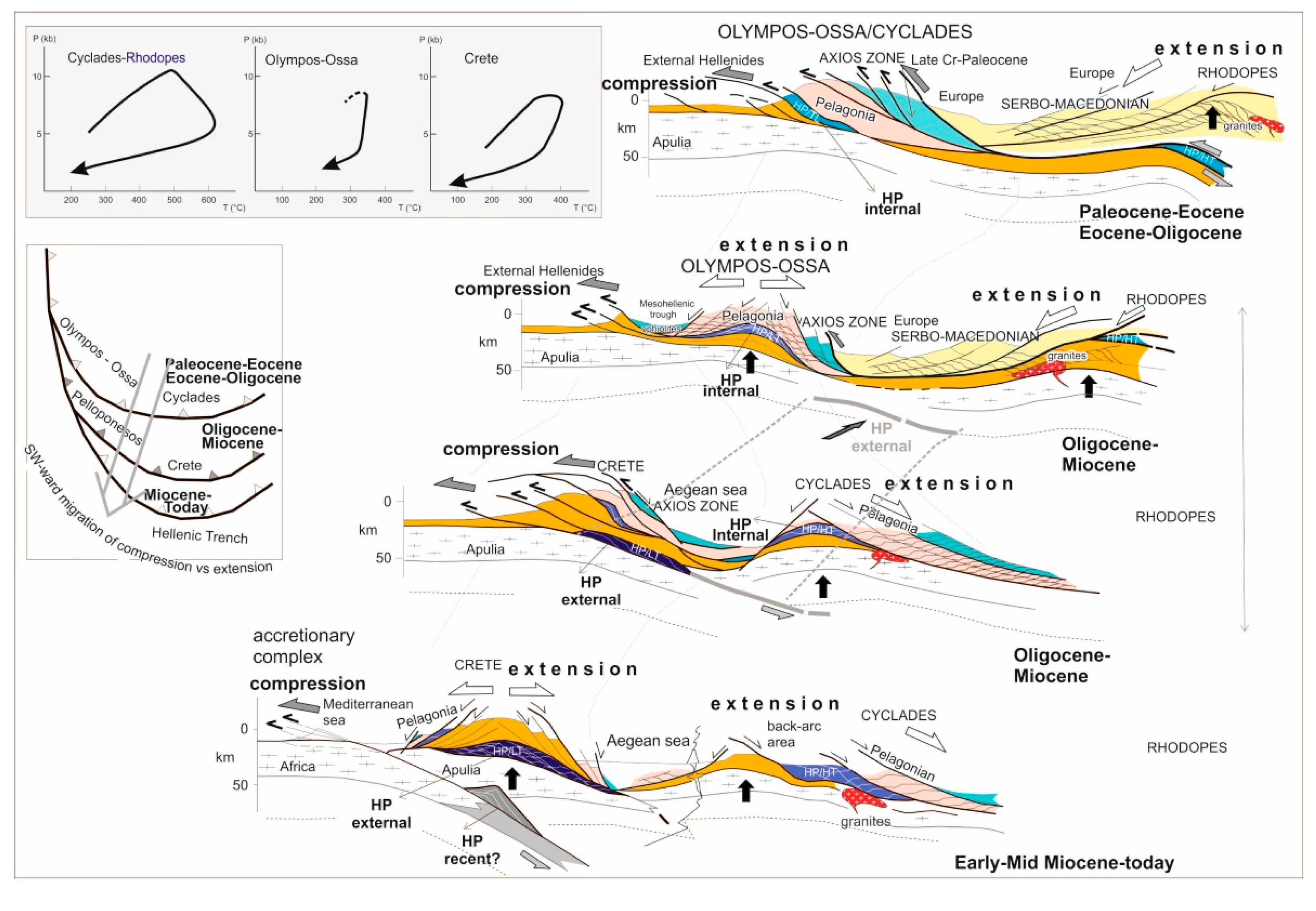
- Alpine deformation and metamorphism are recorded in a multiphase deformational setting from the Early-Middle Jurassic to the present day. Six main (D1 to D6) deformational events were identified that followed, at their early stages, intra-oceanic subduction and ophiolite obduction. Compression, nappe stacking, crustal thickening and high-pressure metamorphism alternated progressively through time with extension, orogenic collapse, mylonites formation and low- to high-temperature metamorphism associated with migmatites formation and granite intrusions in places. Furthermore, the extension is leading to crustal thinning, uplift and exhumation of deep crustal levels as tectonic windows or metamorphic core complexes (e.g., Olympos-Ossa window, Cyclades and Rhodope Pangaion metamorphic core complexes, Cretan and Peloponnese windows). An S-to SW-ward migration of the dynamic peer compression vs. extension is clearly recognized during the Tertiary in the Hellenides. In any case, extension and crustal uplift follow compression and nappe stacking or they take place simultaneously but in different places of the orogen. Today, compression migrated along the Hellenic active subduction zone south of the Crete island.
- III.
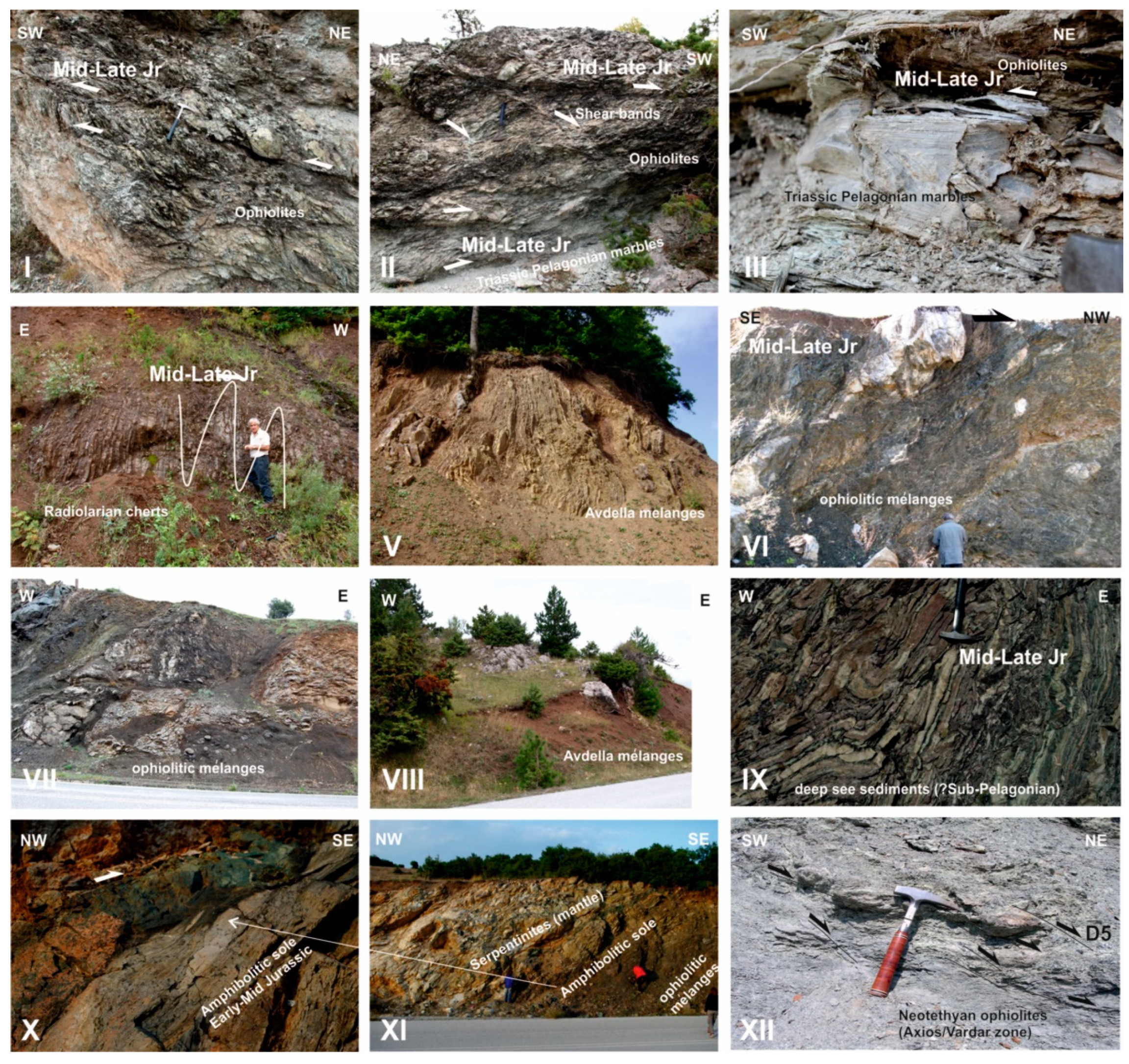
- The ophiolite belts, including the Mid-Late Jurassic ophiolitic mélanges, in the Hellenides are considered far-traveled nappes that originated from a single source ocean, which was the Neotethyan Meliata/Maliac-Axios/Vardar ocean basin. Nappe thrusting and ophiolite overriding were started during the Early-Middle Jurassic, related to the evolution of an intra-oceanic E-ward dipping subduction in the Meliata/Maliac ocean. The upper limit of the ophiolite emplacement on the Apulian (Pelagonia) and European (Vertiskos-Kimi unit) continental margins, respectively, is the Callovian-Oxfordian. The Axios/Vardar ocean closed finally during the Paleocene-Eocene, subducting totally under the European continental margin. As a result, the Vertisko-Kimi unit, as part of the European margin, overthrusts during the late Late Cretaceous-Paleocene the Sidironero-Kerdylia unit, composed of imbricated continental parts and pieces of the Axios/Vardar NE-ward subducted lithosphere. Subsequently, Europe collided with the Pelagonian fragment of Apulian origin.
- IV.
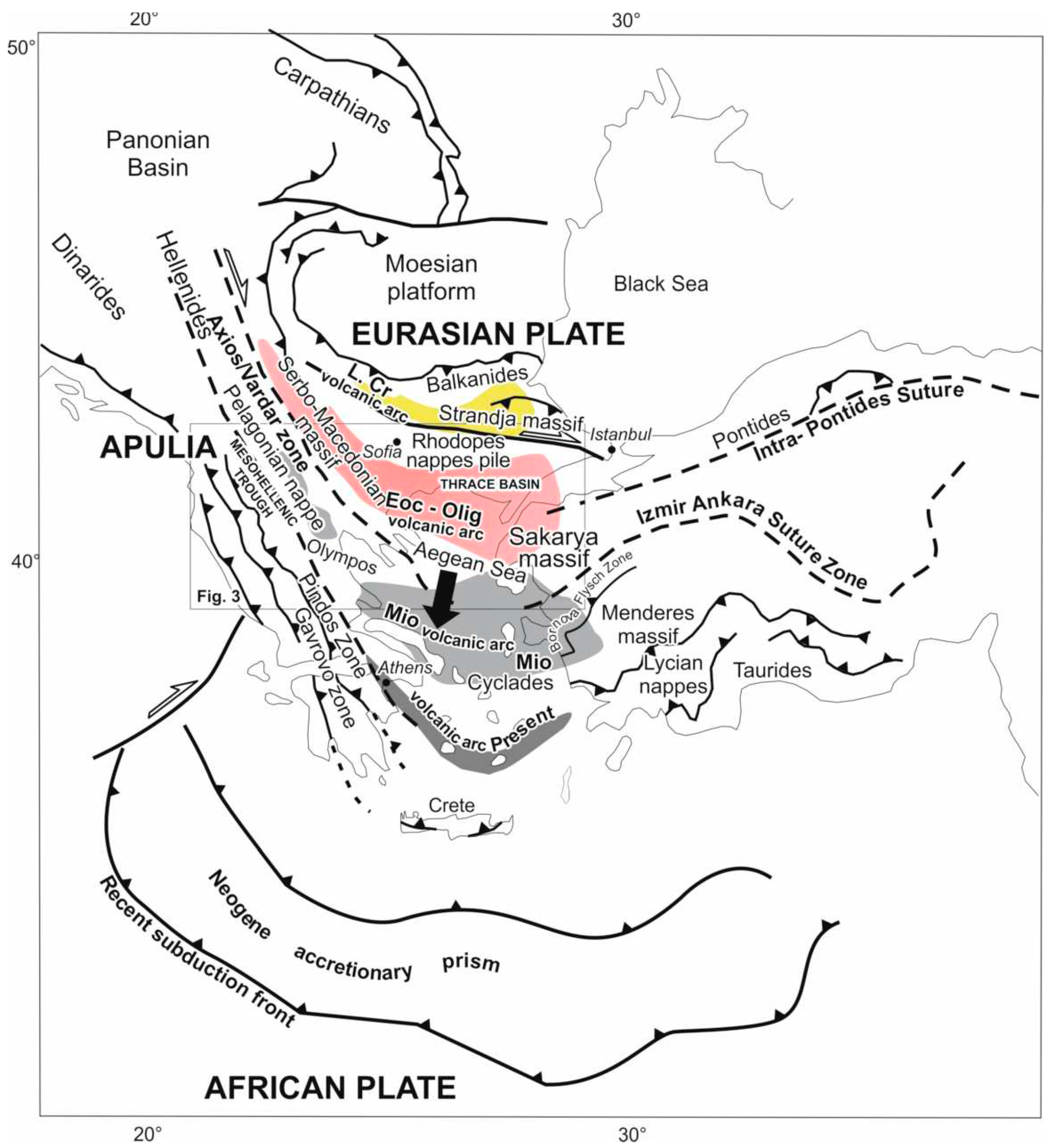
- The Axios/Vardar zone is allochthonous, intensively SW-ward imbricated by the Paleocene-Eocene compressional step-stage. The Axios/Vardar ophiolites along the Axios/Vardar zone form the exposed surface parts of the deep-seated Axios/Vardar suture, which is traced at depth in between the Rhodopes nappes. The Internal Hellenides Serbo-Macedonian/Rhodope thrust stack is rooted along this Axios/Vardar suture.
- V.
- The lower-most Pangaion Rhodope unit should be the Apulian plate`s eastern marginal part. It was underthrusted along the unified Nestos-Ampelakia-Cyclades ductile thrust zone during the Eocene-Oligocene below the Pelagonian and the Serbo-Macedonian/Rhodope nappes stack, following the Paleocene-Eocene subduction of the small Pindos-Cyclades ocean under the Pelagonian fragment. This model, in agreement with Jahn-Awe et al. 2010 and Froitzheim et al. 2014 assumes an E-NE-ward, far-traveled underthrusting of the Apulia plate below the Pelagonian and the Serbo-Macedonian/Rhodope nappes pile. Finally, the lower-most Pangaion Rhodope unit exhumed as a metamorphic core complex below the Serbo-Macedonian/Rhodope nappes stack during the Oligocene-Miocene extensional tectonics of the Internal Hellenides and the broader Aegean region. Respectively, the Serbo-Macedonian/Rhodope nappes were exhumed progressively under an extensional regime, initially with the exhumation of the Vertiskos-Kimi unit during the Paleocene-Eocene, followed by the exhumation of the Sidironero-Kerdylia unit during the Eocene-Oligocene. On the contrary, during the Tertiary in the External Hellenides, compression and nappe thrusting dominate, migrating S-SW-ward until the today active Hellenic subduction zone, causing also the Oligocene-Miocene subduction processes. Moreover, Oligocene-Miocene HP/LT metamorphism is recognized between the External Hellenides in the southern Peloponnese and Crete island (Plattenkalk series and Phyllit-Quartzite unit). Here, the Early-Middle Miocene extension followed, causing a series of tectonic windows and metamorphic core complexes.
- VI.
- During the Eocene-Oligocene the Pelagonian nappe with the obducted ophiolite nappes and the Ampelakia-Cyclades Paleocene-Eocene high-pressure belt were emplaced on the External Hellenides Gavrovo carbonate platform (Apulia plate). The latter exhumed subsequently during the Oligocene-Miocene extension, forming the Olympos-Ossa tectonic window as well as the Cyclades and Pangaion metamorphic core complexes simultaneously with the Oligocene-Miocene compression, subduction and SW-S-ward nappes stacking in the External Hallenides.
- VII.
- A retreating subduction zone and rollback of the subducted Pindos-Cyclades lithospheric slab and/or mantel delamination processes, could well explain the Tertiary S- to SW-ward migration of the compressional and extensional tectonics. Compression is related to nappes stack and crustal thickening, extension to nappes denudation, crustal uplift, and crustal thining. Extension normally follows compression.
Funding
Data Availability Statement
Acknowledgments
Conflicts of Interest
References
- Jacobshagen, V. , Dürr, F., Kockel, K., Kopp, K.O., Kowalczyk, G., Berckhemer, H., Buttner, D., 1978. Structure and geodynamic evolution of the Aegean region, in: Cloos H, Roeder D, Schmidt K, (eds), IUGG, S. (Ed.), Alps, Apennines, Hellenides, 537–564.
- Jacobshagen, V. 1986: Geologie von Griechenland. Beiträge zur regionalen Geologie der Erde, Band 19, Gebrüder Bornträger, Berlin, 363 pp.
- Mountrakis, D.M. , 1986. The Pelagonian Zone in Greece: A Polyphase-Deformed Fragment of the Cimmerian Continent and Its Role in the Geotectonic Evolution of the Eastern Mediterranean. J. Geol., 94, 335–347. [CrossRef]
- Ricou, L.E. , Burg, J.P., Godfriaux, I., Ivanov, Z., 1998. Rhodope and Vardar: The metamorphic and the olistostromic paired belts related to the Cretaceous subduction under Europe. Geodin. Acta 11, 285–309. [CrossRef]
- Kilias, A. , Tranos, M.D., Orozco, M., Alonso-Chaves, F.M., Soto, J.I., 2002. Extensional collapse of the Hellenides: A review. Rev. la Soc. Geol. Espana, 15, 129–139.
- Kilias, A. , Frisch, W., Avgerinas, A., Dunkl, I., Falalakis, G., Gawlick, H.-J., 2010. Alpine architecture and kinematics of deformation of the northern Pelagonian nappe pile in the Hellenides. Austrian J. Earth Sci., 103, 4–28.
- Kilias, A. , Falalakis, G., Sfeikos, A., Papadimitriou, E., Vamvaka, A., Gkarlaouni, C., 2013. The Thrace basin in the Rhodope province of NE Greece - A tertiary supradetachment basin and its geodynamic implications. Tectonophysics, 595–596, 90–105. [CrossRef]
- Stampfli, G.M. , Borel, G.D., 2002. A plate tectonic model for the Paleozoic and Mesozoic constrained by dynamic plate boundaries and restored synthetic oceanic isochrons. Earth Planet. Sci. Lett., 196, 17–33. [CrossRef]
- Jolivet, L. , Rimmele, G., Oberhansli, R., Goffe, B., Candan, O., 2004. Correlation of syn-orogenic tectonic and metamorphic events in the Cyclades, the Lycian nappes and the Menderes massif. Geodynamic implications. Bull. la Soc. Geol. Fr., 175, 217–238. [CrossRef]
- Jolivet, L. , Brun, J.P., 2010. Cenozoic geodynamic evolution of the Aegean. Int. J. Earth Sci., 99, 109–138. [CrossRef]
- Schmid, S.M. , Bernoulli, D., Fügenschuh, B., Matenco, L., Schefer, S., Schuster, R., Tischler, M., Ustaszewski, K., 2008. The Alpine-Carpathian-Dinaridic orogenic system: Correlation and evolution of tectonic units. Swiss J. Geosci., 101, 139–183. [CrossRef]
- Schmid, S. , Fügenschuh, B., Kounov, A., Mațenco, L., Nievergelt, P., Oberhänsli, R., Pleuger, J., Schefer, S., Schuster, R., Tomljenović, B., Ustaszewski, K., Hinsbergen, D.J.J., 2020. Tectonic units of the Alpine collision zone between Eastern Alps and western Turkey. Gondwana Research, 78, 308–374. [CrossRef]
- Gawlick, H.J. , Frisch, W., Hoxha, L., Dumitrica, P., Krystyn, L., Lein, R., Missoni, S., Schlagintweit, F., 2008. Mirdita Zone ophiolites and associated sediments in Albania reveal Neotethys Ocean origin. Int. J. Earth Sci. 97, 865–881. [CrossRef]
- Dilek, Y. , Shallo, M., Furnes, H., 2008, Geochemistry of the Jurassic Mirdita Ophiolite (Albania) and the MORB to SSZ evolution of a marginal basin oceanic crust. Lithos, 100, 174–209.
- Dilek,Y., Altunkaynak, S., Oener, Z., 2009. Syn-extensional granitoids in the Menderes core complex and the late Cenozoic extensional tectonics of the Aegean province. Geol. Soc. London, Special Publication, 321, 197-223. [CrossRef]
- Saccani, E. , Bortolotti, V., Marroni, M., Pandolfi, L., Photiades, A., Principi, G., 2008. The Jurassic association of backarc basin ophiolites and calc-alkaline volcanics in the Guevgueli Complex (NorthernGreece): Implication for the evolution of the Vardar Zone. 33. [CrossRef]
- Jahn-Awe, S. , Froitzheim, N., Nagel, T.J., Frei, D., Georgiev, N., Pleuger, J., 2010. Structural and geochronological evidence for Paleogene thrusting in the western Rhodopes, SW Bulgaria: Elements for a new tectonic model of the Rhodope Metamorphic Province. Tectonics, 29, 1–30. [CrossRef]
- Burg, J.P. , 2012. Rhodope: From mesozoic convergence to cenozoic extension. Review of petro-structural data in the geochronological frame. J. Virtual Explor. 42. [CrossRef]
- Robertson, A.H.F. , 2012. Late Palaeozoic–Cenozoic tectonic development of Greece and Albania in the context of alternative reconstructions of Tethys in the Eastern Mediterranean region. Int. Geol. Rev., 54, 373–454. [CrossRef]
- Bortolotti, V. , Chiari, M., Marroni, M., Pandolfi, L., Principi, G., Saccani, E., 2013. Geodynamic evolution of ophiolites from Albania and Greece (Dinaric-Hellenic belt): One, two, or more oceanic basins? Int. J. Earth Sci. 102, 783–811. [CrossRef]
- Robertson, A.H.F. , Trivić, B., Derić, N., Bucur, I.I., 2013. Tectonic development of the Vardar ocean and its margins: Evidence from the Republic of Macedonia and Greek Macedonia. Tectonophysics, 595–596, 25–54. [CrossRef]
- Papanikolaou, D. , 2009. Timing of tectonic emplacement of the ophiolites and terrane paleogeography in the Hellenides. Lithos, 108, 262–280. [CrossRef]
- Papanikolaou, D. , 2013. Tectonostratigraphic models of the Alpine terranes and subduction history of the Hellenides. Tectonophysics, 595–596, 1–24. [CrossRef]
- Froitzheim, N. , Jahn-Awe, S., Frei, D., Wainwright, A.N., Maas, R., Georgiev, N., Nagel, T.J., Pleuger, J., 2014. Age and composition of meta-ophiolite from the Rhodope Middle Allochthon (Satovcha, Bulgaria): A test for the maximum-allochthony hypothesis of the Hellenides. Tectonics, 33, 1477–1500. [CrossRef]
- Brunn, J.H. , 1956. Contribution à l’étude géologique du Pinde septentrional et d’ une partie de la Macédoine occidnetale. Ann. Géol. Pays Helléniques, 7, 1–358.
- Aubouin, J. , 1959. Contribution a l’ étude géologique de la Grèce septentrional : les confins de l’ Epire et de la Thessaly. Ann. Géol. des Pays Helléniques, 10, 1–525.
- Mercier, J. , 1968. Étude géologique des zones internes des Hellénides en Macédoine centrale (Grèce). Contribution é l’ étude du métamorphisme et de l’ évolution magmatique des zones internes des Hellénides. Ann. Géol. Pays Helléniques, 20, 1–792.
- Zouros, N. , Mountrakis, D., 1991. The thrusting of the Pindos zone and the relationship between the External geotectonic zones in Metsovo-eastern Zagori area (NW Greece). Bull. Geol. Soc. Greece, 25, 245-262.
- Zouros, N. , 1993. Study of the tectonic structures connected with the Pindos nappe in Epirus (NW Greece), PhD Thesis, Univ. of Thessaloniki, Greece; p. 630.
- Kilias, A. , Thomaidou, E., Katrivanos, E., Vamvaka, A., Fassoulas, Ch., Pipera, K., Falalakis, G., Avgerinas, S., Sfeikos, A., 2016. A geological cross-section through northern Greece from Pindos to Rhodope Mountain Ranges: a field guide accross the External and Internal Hellenides. In: (Eds.) Kilias, A. and Lozios, S., Geological field trips in the Hellenides, Journal of the Virtual Explorer, Electronic Edition, 50, 1. [CrossRef]
- Seidel, E. , Kreuzer, H., Harre, W., 1982. A Late Oligocene/Early Miocene high pressure belt in the external Hellenides. Geol. Jahrb., 23, 165–206.
- Kilias, A. , Fassoulas, C., Mountrakis, D., 1994. Tertiary extension of continental crust and uplift of Psiloritis metamorphic core complex in the central part of the Hellenic Arc (Crete, Greece). Geol. Rundschau, 83, 417–430. [CrossRef]
- Fassoulas, C. , Kilias, A., Mountrakis, D., 1994. Postnappe stacking extension and exhumation of high-pressure/low-temperature rocks in the island of Crete, Greece. Tectonics 13, 127–138. [CrossRef]
- Jolivet, L. , Goffé, B., Monié, P., Truffert-Luxey, C., Patriat, M., Bonneau, M., 1994. Miocene detachment in Crete and exhumation P-T-t paths of high-pressure metamorphic rocks. Tectonics, 15(6), 1129–1153. doi.org/10.1029/96TC01417. [CrossRef]
- Stöckhert, B. , Wachmann, M., Küster, M., Bimmermann, S., 1999. Low effective viscosity during high pressure metamorphism due to dissolution precipitation creep: The record of HP-LT metamorphic carbonates and siliciclastic rocks from Crete. Tectonophysics, 303(1-4), 299–319. [CrossRef]
- Godfriaux, I. , 1968. Étude géologique de la region de l’Olympe (Grèce). Ann. Géolog. des Pays Helléniques, 19, 1–281.
- Vergely, P. , 1984. Tectoniques des ophiolites dans les Hellénides Internes déformation, métamorphisme et phénomènes sédimentaires. Conséquences sur l’ évolution des région Téthysiennes Occidentales. PhD Thesis, University Paris-Sud, Orsay.
- Schermer, E.R. , 1990. Mechanisms of blueschist creation and preservation in an A-type subduction zone, Mount Olympos region, Greece. Geology, 18, 1130-1133. [CrossRef]
- Schermer, E.R. , 1993. Geometry and kinematics of continental basement deformation during the Alpine orogeny, Mt. Olympos region, Greece. J. Struct. Geol., 15, 571–591. [CrossRef]
- Bonev, N. , Burg, J.P., Ivanov, Z., 2006. Mesozoic-Tertiary structural evolution of an extensional gneiss dome-The Kesebir-Kardamos dome, eastern Rhodope (Bulgaria-Greece). Int. J. Earth Sci. 95, 318–340. [CrossRef]
- Bonev, N. , Marchev, P., Moritz, R., Collings, D., 2015. Jurassic subduction zone tectonics of the Rhodope Massif in the Thrace region (NE Greece) as revealed by new U–Pb and 40Ar/39Ar geochronology of the Evros ophiolite and high-grade basement rocks. Gondwana Research, 27, 760–775. [CrossRef]
- Bonev, N. , Moritz, R., Borisova, M., Filipov, P., 2018. Therma-Volvi-Gomati complex of the Serbo-Macedonian Massif, Northern Greece: A Middle Triassic continental margin ophiolite of Neotethyan origin. Journal of the Geological Society. [CrossRef]
- Schenker, F.L. , Fellin, M.G., Burg, J.P., 2015. Polyphase evolution of Pelagonia (northern Greece) revealed by geological and fission-track data. Solid Earth, 6, 285–302. [CrossRef]
- Altherr, R. , Schliestedt, M., Okrusch, M., Seidel, E., Kreuzer, H., Harre, W., Lenz, H., Wendt, I., Wagner, G., 1979. Geochronology of high- pressure rocks on Sifnos (Greece, Cyclades). Contrib. Miner. Petrol., 70, 245—255. [CrossRef]
- Wijbrans, J.R. , McDougall, I., 1986. 40Ar/39Ar dating of white micas from an Alpine high-pressure metamorphic belt on Naxos (Greece): the resetting of the argon isotopic system. Contrib. to Mineral. Petrol., 93, 187–194. [CrossRef]
- Okrusch, M. , Broecker, M., 1990. Eclogites associated with highgrade blueschists in the Cycladic archipelago, Greece: a review. European Journal of Mineralogy, 2, 451-478.
- Schermer, E.R. , Lux, D.R., Burchfiel, B.C., 1990. Temperature-time history of subducted continental crust, Mount Olympos Region, Greece. Tectonics, 9, 1165–1195. [CrossRef]
- Kilias, A. , Fassoulas, C., Priniotakis, M., Frisch, W., Sfeikos, A., 1991. Deformation and HP/LT metamorphic condition at the tectonic window of Kranea (W. Thessaly, N. Greece). Z. Dtsch. Geol. Ges., 142, 87–96.
- Broecker, M. , Kreuzer, H., Matthews, A., Okrusch, M., 1993. 40Ar/39Ar and oxygen isotope studies of polymetamorphism from Tinos Island, Cycladic blueschist belt, Greece. Journal of Metamorphic Geology, 11, 223-240.
- Wawrzenitz, N. , Mposkos, E., 1997. First evidence for Lower Cretaceous HP/HT-Metamorphism in the Eastern Rhodope, North Aegean Region, North-East Greece. Eur. J. Mineral., 9, 659–664. [CrossRef]
- Liati, A.L. , Gebauer, D.G., 1999. Constraining the prograde and retrograde P/T/t-path of Eocene HP rocks by SHRIMP dating of different zircon domains: Inferred rates of heating, burial, cooling and exhumation for central Rhodope, northern Greece. Contrib. to Mineral. Petrol., 135, 340–354. [CrossRef]
- Mposkos, E.D. , Kostopoulos, D.K., 2001. Diamond, former coesite and supersilicic garnet in metasedimentary rocks from the Greek Rhodope: A new ultrahigh-pressure metamorphic province established. Earth Planet. Sci. Lett., 192, 497–506. [CrossRef]
- Liati, A. , 2005. Identification of repeated Alpine (ultra) high-pressure metamorphic events by U-Pb SHRIMP geochronology and REE geochemistry of zircon: The Rhodope zone of Northern Greece. Contrib. to Mineral. Petrol., 150, 608–630. [CrossRef]
- Krenn, K. , Bauer, C., Proyer, A., Kloetzli, U., Hoinkes, G., 2010. Tectonometamorphic evolution of the Rhodope orogen. Tectonics, 29. [CrossRef]
- Schmidt, S. , Nagel, T.J., Froitzheim, N., 2010. A new occurrence of microdiamond-bearing metamorphic rocks, SW Rhodopes, Greece. Eur. J. Mineral., 22, 189–198. [CrossRef]
- Nagel, T.J. , Schmidt, S., Janák, M., Froitzheim, N., Jahn-Awe, S., Georgiev, N., 2011. The exposed base of a collapsing wedge: The Nestos Shear Zone (Rhodope Metamorphic Province, Greece). Tectonics, 30, TC4009,1-17. [CrossRef]
- Kirchenbaur, M. , Munker, C., Schuth, S., Garbe-schonberg, D., Marchev, P., 2012. Tectonomagmatic constraints on the sources of Eastern Mediterranean K-rich lavas. J. Petrol., 53, 27–65. [CrossRef]
- Collings, D,, Savov, I., Maneiro, K., Baxter, E., Harvey, J., Dimitrov, I., 2016. Late Cretaceous UHP metmorphism recorded in kyanite–garnet schists from the Central Rhodope Mountains, Bulgaria. Lithos, 246–247, 165–181.
- Miladinova, I. , Froitzheim, N., Nagel, J.T, Janák, M., Georgiev, N., Fonseca, O.C.R., Sandmann, S., Münker, C., 2018. Late Cretaceous eclogite in the Eastern Rhodopes (Bulgaria): evidence for subduction under the Sredna Gora magmatic arc. Int. J. Earth Sciences, 1-17. [CrossRef]
- Doutsos, Th. , Koukouvelas, I., Zelilidis, A., Kontopoylos, N., 1994. Intracontinental wedging and post-orogenic collapse in the Mesohellenic trough. Geol. Rundschau, 83, 257-275. [CrossRef]
- Ferrière, J. , Reynaud, J.Y., Migiros, G., Proust, J.N., Bonneau, M., Pavlopoulos, A., Houze, A., 1998. Initiation d ’un bassin transporté: l’ exemple du “sillon meso-hellénique” au Tertiaire (Grèce). Comptés Rendus l’Académie Sci., Ser. IIa, Sci. la Terre des Planètes, 326, 567–574. [CrossRef]
- Ferrière, J. , Reynaud, J.-Y., Pavlopoulos, A., Bonneau, M., Migiros, G., Chanier, F., Proust, J.-N., Gardin, S., 2004. Geologic evolution and geodynamic controls of the Tertiary intramontane piggyback Meso- Hellenic Basin, Greece. Bulletin de la Sociète Gèologique de France, v. 175, 361–381. [CrossRef]
- Zelilidis, A. , Piper, D.J.W., Kontopoulos, N., 2002. Sedimentation and basin evolution of the Oligocene–Miocene Mesohellenic basin, Greece: American Association of Petroleum Geologists Bulletin, 86(1), 161–182.
- Vamvaka, A. , Kilias, A., Mountrakis, D., Papaoikonomou I., 2006. Geometry and structural evolution of the Mesohellenic Trough (Greece): a new approach. Geol. Soc. London, special publication, 260, 521-538. [CrossRef]
- Vamvaka, A. , Spiegel C., Frisch W., Danišík M., Kilias A., 2009. Fission track data from the Mesohellenic Trough and the Pelagonian zone in NW Greece: Cenozoic tectonics and exhumation of source areas. International Geology Review, 52/ Issue 2, 223-249. [CrossRef]
- Maravelis, A. , Konstantopoulos, P., Pantopoulos, G., Zelilidis,A., 2007. North Aegean sedimentary basin during te Late Eocene to Early Oligocene based on sedimentological studies on Limnos island (NE Greece). Geol. Carpathica, 58, 455-464.
- Kilias, A. , Vamvaka, A., Falalakis, G., Sfeikos, A., Papadimitriou, E., Gkarlaouni, C., B, K., 2015. The Mesohellenic Trough and the Paleogene Thrace Basin on the Rhodope Massif, their Structural Evolution and Geotectonic Significance in the Hellenides. J. Geol. Geosci., 4, 1–17. [CrossRef]
- Kockel, F. , Mollat, H., Walther, H.W., 1977. Erläuterungen zur Geologischen Karte der Chalkidhiki und angrenzender Gebiete 1:100.000 (Nord-Griechenland). Bundesanstalt fuer Geowissenschaften und Rohstoffe, Hannover, p. 119.
- Psilovikos, A. , 1977. Paleogeographic evolution of the Mygdonia basin and lake (Lagada-Volvi). PHD-Thesis, University Thessaloniki, (in Greek with english abstract), 1-156.
- Pavlides, S.B. , Mountrakis, D.M., 1987. Extensional tectonics of northwestern Macedonia, Greece, since the late Miocene. J. Struct. Geol., 9, 385–392. [CrossRef]
- Koufos, G. , Pavlides, S., 1988. Correlation between the continental deposits of the Lower Axios Valley and Ptolemais Basin. Bull. Soc. Geol. Greece, 20, 9-19.
- Syrides, G. , 1990. Lithostratigraphical, Biostratigraphical and Paleographical study of the Neogene-Quaternary sedimentary formations of the Chalkidiki Peninsula. PhD University Thessaloniki (in Greek with english abstract), 1-241.
- Ioakim, Ch. , Rondoyianni, Th., Mettos, A., 2005. The Miocene basins of Greece from a paleoclimatic prospective. Revue de Paleobiologie, 24, 735-748.
- Aubouin, J. , Blanchet, R., Cadet, J.-P., Celet, P., Charvet, J., Chorowicz, J., Cousin, M., Rampnoux, J.P., 1970. Essai sur la géologie des Dinarides. Bulletin de la Société Géologique de France. 12/6, 1060-1095.
- Bernoulli, D. , Laubscher, H., 1972. The palinspastic problem of the Hellenides. Eclogae geologicae Helvetiae, 65, 107-118.
- Papanikolaou, D. , 1997. The tectonostratigraphic terranes of the Hellenides. An. Geol. des Pays Helleniques, 37, 33-48.
- Zoumpouli, Ε. , Pomoni-Papaioannou, F., Zelilidis, A., 2010. Studying in the Paxos Zone the carbonate depositional environment changes during upper Cretaceous, in Sami area of Kefallinia Island, Greece. Βull. Geol. Soc. Greece, XLIII, 2, 793-801. [CrossRef]
- Zoumpouli, Ε. , Pomoni-Papaioannou, F., Zelilidis, A., Iliopoulos G., 2013. Biostratigraphical and sedimentological study of an Upper Cretaceous succession in the Sami area (Central Area of Kefallinia, W. Greece). Bull. Geol. Soc. Greece, ΧLVII, 2, 506-518. [CrossRef]
- Zoumpouli, E. , 2016. Carbonate Sedimentation in Kephalonia Island, Paxi Zone, during Mesozoic. PhD Thesis, University Patras, 1-227.
- Bonneau, M. , 1984. Correlation of the Hellenides Nappes in the south-east Aegean and their tectonic reconstruction. Geol. Soc. London, Spec. Publ. 517–527. [CrossRef]
- Skourtsos, M. , Lekkas, E., 2010. Extensional tectonics in Mt Parnon (Peloponnesus, Greece). Int. J. Earth Sci. (Geol. Rundsch.). [CrossRef]
- Seybold, L. , Trepmann, A.C., Janots, E., 2019. A ductile extensional shear zone at the contact area between HP-LT metamorphic units in the Talea Ori, central Crete, Greece: deformation during early stages of exhumation from peak metamorphic conditions. Int. J. Earth Sciences, 108, 213–227. [CrossRef]
- Theye, T. , Seidel, E., 1991. Petrology of low-grade high-pressure metapelites from the External Hellenides (Crete, Peloponnese): A case study with attention to sodic minerals. Eur. J. Mineral., 3, 343–366. [CrossRef]
- Theye, T. , Seidel, E., Vidal, O., 1992. Carpholite, sudoite and chloritoid in low-grade high-pressure metapelites from Crete and the Peloponnese. Eur. J. Mineral., 4, 487–507.
- Godfriaux, I. , Ricou, L.E., 1991. The Paikon, a tectonic window within the Internal Hellenides, Macedonia, Greece. Comptes Rendus - Acad. des Sci. Ser., II 313, 1479–1484.
- Kilias, A. , 1995. Emplacement of the blueschists unit in eastern Thessaly and (central Greece). Miner. Wealth, 96, 7–22.
- Lips,A.L., White, W.S.H., Wijbccrans, J.R., 1998. 40Ar/39Ar laser probe direct dating of discrete deformational events: A continuous record of early Alpine tectonics in the Pelagonian Zone, NW Aegean area, Greece, Tectonophysics, 298, (1-3), 133–153.
- Altherr, R. , Kreuzer, H., Wendt, I., Lenz, H., Wagner, G.-A., Keller, J., Harre, W., Hohndorf, A., 1982. A late Oligocene/early Miocene high temperature belt in the Attico-Cycladic crystalline complex (SE Pelagonian, Greece). Geol. Jahrb., E23, 97-164.
- Lister,G. S., Banga, G., Feenstra, A., 1984. Metamorphic core complexes of cordilleran type in the Cyclades, Aegean Sea,Greece, Geology, 12, 221–225.
- Keay, S. , Lister, G., Buick, I., 2001. The timing of partial melting, Barrovian metamorphism and granite intrusion in the Naxos metamorphic core complex, Cyclades, Aegean Sea, Greece. Tectonophysics, 342, 275–312. [CrossRef]
- Grasemann, B. , Petrakakis, K., 2007. Evolution of the Serifos metamorphic core complex. Journal of the Virtual Explorer, 2007, 27. [CrossRef]
- Iglseder, C. , Grasemann, B., Rice, A.H.N., Petrakakis, K., Schneider, D.A., 2011. Miocene south directed low-angle normal fault evolution on Kea Island (West Cycladic Detachment System, Greece). Tectonics, 30(4), TC4013. [CrossRef]
- Roche, V. , Laurent, V., Luca Cardello, G., Jolivet, L., Scaillet, S., 2016. Anatomy of the Cycladic Blueschist Unit on Sifnos Island (Cyclades, Greece). Journal of Geodynamics, 97, 62-87. [CrossRef]
- Ring, U. , Glodny, J., Peillod, A., Skelton, A., 2018. The timing of hightemperature conditions and ductile shearing in the footwall of the Naxos extensional fault system, Aegean Sea, Greece. Tectonophysics. [CrossRef]
- Linnros, H. , Hansman, R., Ring, U., 2019. The 3D geometry of the Naxos detachment fault and the threedimensional tectonic architecture of the Naxos metamorphic core complex, Aegean Sea, Greece. Intern. Journal of Earth Sciences, 198, 287-300. [CrossRef]
- Engel, M. and Reischmann, T., 1998. Single zircon geochronology of orthogneisses from Paros, Greece. Bull. Geol. Soc. Greece, 32(3), 91-99.
- Reischmann, T. , 1998. Pre-Alpine origin of tectonic units from the metamorphic complex of Naxos, Greece, identified by single zircon Pb/Pb dating. Bulletin of the Geological Society of Greece, 32(3), 101-111.
- Ring, U. , Layer, P.W., Reischmann, T., 2001. Miocene high-pressure metamorphism in the Cyclades and Crete, Aegean Sea, Greece: Evidence for large-magnitude displacement on the Cretan detachment. Geology, 29(5), 395–398.
- Oner Baran, Z. , Dilek, Y., Stockli, D., 2017. Diachronous uplift and cooling history of the Menderes core complex, western Anatolia (Turkey), based on new Zirkon (U-Th)/He ages. Tectonophysics, 2017, 181-196. [CrossRef]
- Lamont, N. Th. , Searle, P. M., Waters, J. D., Roberts, M.W.N., Palin, M. R., Smye, A., Dyck, B., Gopon, Ph., Weller, M.O., Marc R. St-Onge, R.M., 2019. Compressional origin of the Naxos metamorphic core complex, Greece: Structure, petrography, and thermobarometry. GSA Bulletin. [CrossRef]
- Hetzel, R. , Ring, U., Akal, C., Troesch, M., 1995. Miocene NNE-directed extensional unroofing in the Menderes massif, western Turkey. Journal of the Geological Society, London, 152, 639–654.
- Hetzel, R. , Romer, R. l., Candan, O., Passchier, C. W., 1998. Geology of the Bozdag area, central Menderes massif, SW Turkey: Pan-African basement and Alpine deformation. Geologische Rundschau, 87, 394–406. [CrossRef]
- Kilias, A. , Mountrakis, D., Tranos, M., Pavlides, S., 1996. The prevolcanic metamorphic rocks of Santorini island: Structural evolution and kinematics during the Tertiary (South Aegean, Greece). In R. Casale, M. Fytikas, G. Sigvaldasson & G. Vougioukalakis, (Eds.), Volcanic risk. The European laboratory volcanoes, 2nd workshop. Computer Science Research Development, 23–36.
- Ring, U. , Gessner, K., Güngör, T., Passchier, C.W., 1999. The Menderes Massif of western Turkey and the Cycladic Massif in the Aegean—do they really correlate? J. Geol. Soc. London, 156(1), 3–6.
- Hetzel, R. , Reischmann, T., 1996. Intrusion age of Pan-African augen gneisses in the southern Menderes Massif and the age of cooling after Alpine ductile extensional deformation. Geological Magazine, 133, 565–572. [CrossRef]
- Partzsch, J.H. , Oberhansli, R., Candan, O., Warkus, F., 1998. The evolution of the central Menderes massif, West Turkey: a complex nappe pile recording 1.0Ga of geological history. Freib. Forsch., C-471, 166-168.
- Gessner, K. , Piazolo, S., Güngör, T., Ring, U., Kröner, A., Passchier, C. W. 2001. Tectonic significance of deformation patterns in granitoid rocks of the Menderes nappes, anatolide belt, Southwest Turkey. Int. J. of Earth Sci. 89. [CrossRef]
- Bozkurt, E. , Oberhaensli, R., 2001. Menderes Massif (western Turkey): structural metamorphic and magmatic evolution-a synthesis. Int. J. of Earth Sci., 89, 679-708.
- Altherr, R. , Siebel, W. 2002. I-type plutonism in a continental back-arc setting: Miocene granitoids and monzonites from the central Aegean Sea, Greece. Contributions to Mineralogy and Petrology, 143(4), 397-415. [CrossRef]
- Ring, U. , Thomson, S., Broecker, N.M., 2003. Fast extension but little exhumation: the Vari detachment in the Cyclades, Greece. Geol. Mag., 140, 245–252. [CrossRef]
- Jolivet, L. , Lecomte, E., Huet, B., Denèle, Y., Lacombe, O., Labrousse, L., Mehl, C. 2010. The North Cycladic Detachment System. Earth and Planetary Science Letters, 289(1–2), 87–104. [CrossRef]
- Brunn, J.H. , Argyriadis, I., Ricou, L.E., Poisson, A., Marcoux, J., Graciansky, P.C., 1976. Eléments majeurs de liaison entre Taurides et Hellénides. Bull. Soc. Géol. Fr., XVIII, 2, 481-497. [CrossRef]
- Robertson, A.H.F. , Dixon, J.E., Brown, S., Collins, A., Morris, A., Pickett, E., Sharp, I., Ustaomer, T., 1996. Alternative tectonic models for the Late Palaeozoic-Early Tertiary development of Tethys in the Eastern Mediterranean region. Geol. Soc. London, Spec. Publ., 105, 239–263. [CrossRef]
- Dinter, D.A. , 1998. Late Cenozoic extension of the Alpine collisional orogen, northeastern Greece: Origin of the north Aegean Basin. Bull. Geol. Soc. Am. 110, 1208–1230. [CrossRef]
- Rassios, A.H.E. , Moores, E.M., 2006. Heterogeneous mantle complex, crustal processes, and obduction kinematics in a unified Pindos-Vourinos ophiolitic slab (northern Greece). Tecton. Dev. East. Mediterr. Reg., 260, 237–266. [CrossRef]
- Rassios, A.E. , Dilek, Y., 2009. Rotational deformation in the Jurassic Mesohellenic ophiolites, Greece, and its tectonic significance. Lithos, 108, 207–223. [CrossRef]
- Petrík, I. , Janák, M., Froitzheim, N., Georgiev, N., Yoshida, K., Sasinková, V., Konečný, P., Milovská, S., 2016. Triassic to Early Jurassic (c. 200 Ma) UHP metamorphism in the Central Rhodopes: evidence from U–Pb–Th dating of monazite in diamondbearing gneiss from Chepelare (Bulgaria). J. Metamorph. Geol., 34, 265–291.
- Papanikolaou, D. , 1987. Tectonic evolution of the Cycladic blueschist belt (Aegean Sea, Greece). In: Helgeson, H.C. (Ed.), Chemical Transport in Metasomatic Processes: NATO ASI Series, 429-450.
- Kilias, A. , 2018a. The Hellenides: A complicated, multiphase deformed Alpine orogenic belt. Compression vs. extension, the dynamic peer for the orogen making. Proccedings of the 9th International INQUA Meeting on Paleoseismology, Active Tectonics and Archeoseismology (PATA), 119-123, Possidi, Greece.
- Killias, A. , 2018b. The Hellenides, a complicated, multiphase Alpine orogenic belt. New aspects for the geotectonic evolution of the Hellenides: A review. XXI International Congress of the CBGA, Salzburg, Austria, Abstract.
- Stampfli, G.M. , Vavassis, I., De Bono, A., Rosselet, F., Matti, B., Bellini, M., 2003. Remnants of the paleotethys oceanic suture-zone in the western Tethyan area. Bull. Soc. Geol. Italia, 2, 1–23.
- Savoyat, E. , Lalechos, N., 1972, Geological Map of Greece, scale 1:50.000, Kalampaka Sheet. Institute of Geology and Mineral Exploration, Athens.
- Lekkas, E. , 1987. Geological structure and geodynsmic evolution of the Koziakas Mountain (western Thessaly, Greece). PhD Thesis, University Athens, (in Greek with English abstract).
- Karfakis, I. , Skourtsi-Koroneou, B., Ioakim, Chr., Kanaki-Mavridou, 1993. Geological Map of Greece, scale 1:50,000, Moyzakion Sheet. Institute of Geology and Mineral Exploration, Athens.
- Nirta, G. , Moratti, G., Piccardi, L., Montanari, D., Catanzariti, R., Carras, N., Papini, M., 2015. The boeotian flysch revisited: New constraints on ophiolite obduction in central Greece. Ofioliti 40(2), 107-123. [CrossRef]
- Ghon, G. , 2017. Mikrofazielle Untersuchung einer karbonatklastischen Beckenfüllung im Hangenden der ophiolitführenden Koziakas Mélange in Kori, Nordgriechenland. Bachelror Arbeit, University Leoben, 1-20.
- Ghon, G. , Gawlick, H.J., Missoni, S., Djeric, N., Kilias, A., Goričan, Š., 2018. Age and microfacies of a carbonate-clastic radiolaritic basin fill above the Koziakas Mélange (Hellenides, Greece). XXI Inter. Congress of the CBGA, (abstract), Salzburg, Austria.
- Chiari, M. , Bortolotti, V., Marcucci, M. Ch., Saccani, E., 2012. Radiolarian Biostratigraphy and Geochemistry of the Koziakas Massif Ophiolites (Greece). Bull. Soc. Géol. France, 183 (4), 287-306. [CrossRef]
- Yarwood, G.A. , Aftalion, M., 1976. Field relations and U-Pb geochronology of a granite from the Pelagonian zone of the Hellenides (High Pieria, Greece). Bull. Soc. Géol. Fr., 18, 259–264.
- Mountrakis, D. , Sapountzis, E., Kilias, A., Eleftheriadis, G., Christofides, G., 1983. Paleogeographic conditions in the western Pelagonian margin in Greece during the initial rifting of the continental area. Can. J. Earth Sci., 20, 1673–1681. [CrossRef]
- Kilias, A. , Mountrakis, D., 1989. The Pelagonian nappe. Tectonics, metamorphism and magmatism (in Greek with English abstract). Bull. Soc. Geol. Greece, 20, 29–46.
- Koroneos, A. , Christofides, G., Del Moro, A., Kilias, A., 1993. Rb-Sr geochronology and geochemical aspects of the Eastern Varnountas plutonite (NW Macedonia, Greece). Neues Jahrb. fur Mineral. Abhandlungen, 165, 297–315.
- Koroneos, A. , Kilias, A., Avgerinas, A., 2013. Hercynian plutonic rocks of Voras Mountain, Macedonia, Northern Greece: their structure, petrogenesis, and tectonic significance. Int. Geol. Rev., 55, 994–1016. [CrossRef]
- Poli, G. , Christophidis, G., Koroneos, A., Soldatos, T., Perugini, D., Langone, A., 2009. Early Triassic granitic magmatism - Arnea and Kerkini granitic complexes - In the Vertiskos unit (Serbo-macedonian massif, north-eastern Greece) and its significance in the geodynamic evolution of the area. Acta Vulcanol., 21, 47–70.
- Michard, A. , Feinberg, H., Montigny, R., 1998. Supra-ophiolitic formations from the Thessaloniki nappe (Greece), and associated magmatism: An intra-oceanic subduction predates the Vardar obduction. Comptes Rendus l’Academie Sci. - Ser. IIa Sci. la Terre des Planetes, 327, 493–499. [CrossRef]
- Kilias, A. , Tranos, M., Mountrakis, D., Shallo, M., Marto, A., Turku, I., 2001. Geometry and kinematics of deformation in the Albanian orogenic belt during the Tertiary. J. Geodyn., 31, 169–187. [CrossRef]
- Gawlick, H.J. , Missoni, S., 2019. Middle-Late Jurassic sedimentary melange formation related to ophiolite obduction in the Alpine-Carpathian-Dinaric Mountain Range. Gondwana Research. [CrossRef]
- Reinecke,T., Altherr, R., Hartung, B., Hatzipanagiotou, K., Kreuzer, H., Harre, W., Klein, H., Keller, J., Geenen, E., Boeger H., 1982. Remnants of Late Cretaceous high temperature belt on the island of Anafi (Cyclades, Greece), Neus Jahrb. Mineral. Abh., 145, 157–182.
- Sanchez-Gomez, M. , Avigad, D., Heimann, A., 2002. Geochronology of clasts in allochthonous Miocene sedimentary sequences on Mykonos and Paros Islands: implications for back-arc extension in the Aegean Sea. Journal of the Geological Society,159 (1), 45-60. [CrossRef]
- Kruckenberg, S.C. , Ferré, E.C., Teyssier, C., Vanderhaeghe, O., Whitney D.L., Seaton, N.C., Skord, J.A., 2010. Viscoplastic flow in migmatites deduced from fabric anisotropy: an example from the Naxos dome, Greece. J. Geophys. Res, Solid Earth, 115(B9), 1978–2012. [CrossRef]
- Cao, S. , Neubauer, F., Bernroider, M., Liu, J., 2013. The lateral boundary of a metamorphic core complex: the Moutsounas shear zone on Naxos, Cyclades, Greece. J. Struct. Geol., 54, 103–128. [CrossRef]
- Katrivanos, E. , Kilias, A., Mountrakis, D., 2013. Kinematics of deformation and structural evolution of the Paikon Massif (Central Macedonia, Greece): A Pelagonian tectonic window? Neues Jahrb. für Geol. und Paläontologie - Abhandlungen, 269, 149–171. [CrossRef]
- Galeos, A. , Pomoni-Papaioannou, F., Tsaila-Monopolis, S., Turnsek, D., Ioakim, C., 1994. Upper Jurassic-Lower Cretaceous molassic-type sedimentation in the western part of the Almopias subzone, Aridhea Loutra unit (northern Greece). Bull. Geol. Soc. Greece, 30, 171–184.
- Photiades, A. , Skourtsi-Coroneou, V., and Grigoris, P., 1998. The stratigraphic and paleogeographic evolution of the eastern Pelagonian margin during the Late Jurassic – Cretaceous interval (Western Vermion Mountain – Western Macedonia, Greece). Bull. Geol. Soc. Greece, 32(1), 71-77.
- Photiades, A. , Carras, N., in collaboration with Bortolotti V., Fazzuoli M., and Principi G., 2007. The late Early Cretaceous transgression on the laterites in Vourinos and Vermion massifs (western Μacedonia, Greece). Bull. Geol. Soc. Greece, XL, 182-190.
- Bortolotti V, Carras N, Chiari M, Fazzuoli M, Photiades A and Principi G (2004) Sedimentary evolution of the Upper Jurassic Zyghosti platform, Kozani, Northern Greece. In Proceedings of the International Symposium on Earth System Sciences (ISES) 2004, Istanbul, Turkey, –10, 2004, pp. 705–712. 8 September.
- Gawlick, H.J. , Sudar, M., Missoni, S., Aubrecht, R., Schlagintweit, F., Jovanović, D., Mikuš, T., 2020. Formation of a Late Jurassic carbonate platform on top of the obducted Dinaridic ophiolites deduced from the analysis of carbonate pebbles and ophiolitic detritus in southwestern Serbia. Int. J. Earth Sci. [CrossRef]
- Schlagintweit, F. , Gawlick, H.J., Missoni, S., Hoxha, L., Lein, R., Frisch, W., 2008. The eroded Late Jurassic Kurbnesh carbonate platform in the Mirdita Ophiolite Zone of Albania and its bearing on the Jurassic orogeny of the Neotethys realm. Swiss Journal of Geosciences, 101, 125-138. [CrossRef]
- Kostaki, G. , Kilias, A., Gawlick, H.-J., Schlagintweit, F., 2013. Kimmeridgian-Tithonian shallow-water platform clasts from mass flows on top of the Vardar/Axios ophiolites. Bull. Geol. Soc. Greece, XLVII, 1–10. [CrossRef]
- Kostaki, G. , Kilias, A., Gawlick, H.-J., Schlagintweit, F., 2014. Component analysis in the vardar/Axios zone of northern Greece reveals an eroded Late Jurassic carbonate platform comparable to those of the Eastern Alps/Western Carpathian, Dinarides, Albanides and Hellenides. Bul. Shk. Gjeol., 1, 85–88.
- Most, T. , Frisch, W., Dunkl, I., Kodosa, B., Boev, B., Avgerinas, A., Kilias, A., 2001. Geochonological and structural investigation of the Northern Pelagonian crystalline zone. Constraints from K/Ar and zircon and apatite fission track dating. Bull Geol Soc Greece, 34, 91–95.
- Mposkos, E. , Kostopoulos, D., Krohe, A., 2001. Low-P/High-T prealpine metamorphism and medium-P alpine overprint of the Pelagonian zone documented in high-alumina metapelites from the Vernon massif, Western Macedonia, Northern Greece. Bull. Geol. Soc. Greece, 34, 949-958.
- Mposkos, E. , Krohe, A., 2004. New Evidences of the Low-P/High-T Pre-Alpine Metamorphism and Medium-P Alpine Overprint of the Pelagonia Zone Documented in Metapelites and Orthogneisses from the Voras Massif, Macedonia, Northern Greece. Bull. Geol. Soc. Greece, XXXVI, 558-567.
- Schenker, F.L. , Burg, J.P., Kostopoulos, D., Moulas, E., Larionov, A., von Quadt, A., 2014. From mesoproterozoic magmatism to collisional cretaceous anatexis: Tectonomagmatic history of the Pelagonian Zone, Greece. Tectonics, 33, 1552–1576. [CrossRef]
- Kilias, A. , 1991. Transpressive tektonik in den zentralen Helleniden. Aenderung der translations pfade durch die transpression (Nord-zentral Griechenland). Neues Jahrb. für Geol. und Paläentologie, Monatshefte, 20, 291–306.
- Sfeikos, A. , Böhringer, C., Frisch, W., Kilias, A., Ratschbacher, L., 1991. Kinematics of the Pelagonian nappes in the Kranea area, N. Thessaly (Greece). Bull. Geol. Soc. Greece, 25, 101–115.
- Frisch, W. , 1981. Plate motions in the Alpine region and their correlation to the opening of the Atlantic ocean. Geol. Rundschau, 70, 402–411. [CrossRef]
- Tremblay, A. , Meshi, A., Deschamps, T., Goulet, F., Goulet, N., 2015. The Vardar zone as a suture for the Mirdita ophiolites, Albania: Constraints from the structural analysis of the Korabi-Pelagonia zone. Tectonics, 34, 352–375. [CrossRef]
- Robertson, A. , Shallo, M., 2000. Mesozoic-Tertiary tectonic evolution of Albania in its regional Eastern Mediterranean context. Tectonophysics, 316, 197–254. [CrossRef]
- Brown, S.A.M. , Robertson, A.H.F., 2004. Evidence for Neotethys rooted within the Vardar suture zone from the Voras Massif, northernmost Greece. Tectonophysics 381, 143–173. [CrossRef]
- Brown, S.A.M. , Robertson, A.H.F., 2003. Sedimentary geology as a key to understanding the tectonic evolution of the Mesozoic-Early Tertiary Paikon Massif, Vardar suture zone, N Greece. Sediment. Geol., 160, 179–212. [CrossRef]
- Sharp, I.R. , Robertson, A.H.F., 2006. Tectonic-sedimentary evolution of the western margin of the Mesozoic Vardar Ocean: evidence from the Pelagonian and Almopias zones, northern Greece. Geol. Soc. London, Spec. Publ., 260, 373–412. [CrossRef]
- Hoxha, L. , 2001. The Jurassic-Cretaceous orogenic event and its effects in the exploration of sulphide ores, Albanian ophiolites, Albania. Eclogae Geol. Helv., 94, 339–350.
- Michail, M. , Pipera, K., Koroneos, A., Kilias, A., Ntaflos, T., 2016. New perspectives on the origin and emplacement of the Late Jurassic Fanos granite, associated with an intra-oceanic subduction within the Neotethyan Axios-Vardar Ocean. Int. J. Earth Sci., 105, 1965–1983. [CrossRef]
- Ferrière, J. , 1974. Étude géologique d`un sectuer des zones Helléniques internes subpelagonienne et pélagonienne (massif de l`Othrys, Grèce continental). Importance et signification de l période orogénique ante-Cretacé superieur. Bul. de la Soc. Géol. de France, XVI, 543-562.
- Carras, N. , 1995. La piattaforma carbonatica del Parnasso durante il Guirassico Superiore – Cretaceo inferiore. PhD Thesis, Uni. Athens 232 pp. (in Greek with Italian abstract).
- Celet, P. , 1962. Contribution a l` étude géologique du Parnasse-Gkiona et d` une partie des régions méridionales de la Grèce continental. Ann. Géol. Pays Hellén., 13, 1-360.
- Celet, P. , 1977. Les bordures de la zone du Parnasse. `Evolution paleogéographique au Mésozoique et caractères structuraux. VI Coll. Aegean, 725-740, Athens.
- Clement, B. , 1977. Relations structurales entre la zone du Parnasse et la zone Pelagonienne en Beotie. VI Coll. Aegean, 237-251, Athens.
- Carras, N. , Fazzuoli, M., 1992. La Formation des “Calcaires de Amfissa” (“Intermediate Limestones Auctt.), Cretacé inferieur, Zone du Parnasse (Grèce continentale). Ann. Géol. des Pays Helléniques, 35, 43-101.
- Anders, B. , Reischmann, T., Poller, U., Kostopoulos, D., 2005. Age and origin of granitic rocks of the eastern Vardar Zone, Greece: new constraints on the evolution of the Internal Hellenides. J. Geol. Soc. London. 162, 857–870. [CrossRef]
- Šarić, K. , Cvetković, V., Romer, R.L., Christofides, G., Koroneos, A., 2009. Granitoids associated with East Vardar ophiolites (Serbia, F.Y.R. of Macedonia and northern Greece): Origin, evolution and geodynamic significance inferred from major and trace element data and Sr-Nd-Pb isotopes. Lithos, 108, 131–150. [CrossRef]
- Bonneau, M. , Godfriaux, I., Moulas, Y., Fourcade, E., Masse, J., 1994. Stratigraphie et structure de la bordure orientale de la double fenêtre du Paikon (Macédoine, Grèce). Bull. Geol. Soc. Greece, 30, 105–114.
- Danelian, T. , Robertson, A. H. F., Dimitriadis, S., 1996. Age and significance of radiolarian sediments within basic extrusives of the marginal basin Guevgueli Ophiolite (northern Greece), Geol. Mag., 133, 127–136. [CrossRef]
- Zachariadis, P. , 2007. Ophiolites of the eastern Vardar Zone. PhD Thesis, Johannes Gutenberg Universität, Mainz; p. 125.
- Chiari, M. , Bortolotti, V., Marcucci, M., Photiades, A., Principi, G., 2003.The Middle jurassic siliceous sedimentary cover at the top of the vourinos ophiolite (Greece). Ophioliti, 28, 95-103.
- Frisch, W. , Meschede, M., 2007. Plattentektonik: Kontinentverschiebung und Gebirgsbildung. 2., aktualisierte Auflage, WBG, Darmstad, p. 196.
- Ferrière, J. , Chanier, F., Ditbanjong, P., 2012. The Hellenic ophiolites: eastward or westward obduction of the Maliac Ocean, a discussion. Int. J. Earth Sci. (Geol. Rundsch.) 101, 1559–1580. [CrossRef]
- Bonev, N.G. , Stampfli, G.M., 2003. New structural and petrologic data on Mesozoic schists in the Rhodope (Bulgaria): Geodynamic implications. Comptes Rendus - Geosci., 335, 691–699. [CrossRef]
- Bonev, N. , Stampfli, G., 2008. Petrology, geochemistry and geodynamic implications of Jurassic island arc magmatism as revealed by mafic volcanic rocks in the Mesozoic low-grade sequence, eastern Rhodope, Bulgaria. Lithos, 100, 210–233. [CrossRef]
- Bonev, N. , Stampfli, G., 2011. Alpine tectonic evolution of a Jurassic subduction-accretionary complex: deformation, kinematics and 40Ar/39Ar age constraints on the Mesozoic low-grade schists of the Circum-Rhodope Belt in the eastern Rhodope–Thrace region, Bulgaria–Greece. J. Geodyn., 52, 143–167.
- Koglin, N. , Kostopoulos, D., Reischmann, T., 2009. Geochemistry, petrogenesis and tectonic setting of the Samothraki mafic suite, NE Grecce: trace-element, isotopic and zirkon age constraints. Tectonophysics, 473, 53-68. [CrossRef]
- Kilias, A. , 2019. Architecture of the Alpine Deformation and Geotectonic Setting of the Hellenides. A synthesis. Proceedings of the 15th International Congress of the Geol. Soc. Grrecce, Bull. Geol. Soc. Greece, Sp. Publ., 7, 158-159.
- Robertson, A.H.F. , 2002. Overview of the genesis and emplacement of Mesozoic ophiolites in the Eastern Mediterranean region. Lithos, 65, 1-68. [CrossRef]
- Ustaszewski, K. , Schmid, S.M., Lugović, B., Schuster, R., Schaltegger, U., Bernoulli, D., Hottinger, L., Kounov, A., Fügenschuh, B., Schefer, S., 2009. Late Cretaceous intra-oceanic magmatism in the internal Dinarides (northern Bosnia and Herzegovina): Implications for the collision of the Adriatic and European plates. [CrossRef]
- Ustaszewski, K. , Kounov, A., Schmid, M.S., Schaltegger, U., Krenn, E., Frank, W., Fügenschuh, B., 2010. Evolution of the Adria-Europe plate boundary in the northern Dinarides: From continent-continent collision to back-arc extension. 6017; 29. [Google Scholar] [CrossRef]
- Medwenitsch, W. , 1956. Zur Geologie Vardarisch-Makedoniens (Jugoslawien), zum Problem der Pelagoniden. Oestereichische Akademie der Wissenschaften, Sitzungsberichte der mathematisch naturwissenschaftlichen Klasse, Abteilung 1, 165, 397-473.
- Ring, U. , Glodny, J., Will, T., Thomson, S., 2010. The Hellenic Subduction System: High-Pressure Metamorphism, Exhumation, Normal Faulting, and Large-Scale Extension. Annu. Rev. Earth Planet. Sci., 38, 45–76. [CrossRef]
- Glodny, J. , Ring, U., 2021. The Cycladic Blueschist Unit of the Hellenic subduction orogen: Protracted high-pressure metamorphism, decompression and reimbrication of a diachronous nappe stack. [CrossRef]
- Ring, U. , Will, T., Glodny, J., Kumerics, C., Gessner, K., et al., 2007. Early exhumation of high-pressure rocks in extrusion wedges: Cycladic blueschist unit in the eastern Aegean, Greece, and Turkey. Tectonics 26:TC2001.
- Keay, S. 1998. The geological evolution of the Cyclades, Greece: constraints from SHRIMP U-Pb geochronology. PhD thesis. Aust. Natl. Univ., Canberra, 1-335.
- Tomaschek, F. , Kennedy, A. K., Villa, I. M., Lagos, M., Ballhaus, C., 2003. Zircons from Syros, Cyclades, Greece-Recrystallization and mobilization of zircon during high-pressure metamorphism, J. Petrol., 44, 1977–2002. [CrossRef]
- Ring, U. , Layer, P.W., 2003: High-pressure metamorphism in the Aegean, eastern Mediterranean: underplating and exhumation from the Late Cretaceous until the Miocene to recent above the retreating Hellenic subduction zone. Tectonics, 22(3), 1022. [CrossRef]
- Avigad, D. , Garfunkel, Z., Jolivet, L. & Azanon, J.M., 1997. Back arc extension and denudation of Mediterranean eclogites. Tectonics, 16, 924–941. [CrossRef]
- Kilias, A. , Mountrakis, D., 1990. Kinematics of the crystalline sequences in the western Rhodope massif. Geol. Rhodopica, 2, 100–116.
- Burg, J.P. , Ricou, L.E., Ivanov, Z., Godfriaux, I., Dimov, D., Klain, L., 1996. Syn-metamorphic nappe complex in the rhodope massif. Structure and kinematics. Terra Nova, 8, 6–15. [CrossRef]
- Kilias, A. , Mountrakis, D., 1998. Tertiary extension of the Rhodope massif associated with granite emplacement (Northern Greece). Acta Vulcanol., 10, 331–337.
- Kilias, A. , Falalakis, G., Mountrakis, D., 1999. Cretaceous-Tertiary structures and kinematics of the Serbomacedonian metamorphic rocks and their relation to the exhumation of the Hellenic hinterland (Macedonia, Greece). Int. J. Earth Sci., 88, 513–531. [CrossRef]
- Krohe, A. , Mposkos, E., 2002. Multiple generations of extensional detachments in the Rhodope Mountains (northern Greece): Evidence of episodic exhumation of high-pressure rocks, Geological Society London, Special Publication. [CrossRef]
- Brun, J.-P. , Sokoutis, D., 2007. Kinematics of the Southern Rhodope Core Complex (North Greece). Int. J. Earth Sci. 96, 1079–1099. [CrossRef]
- Turpaud, P. , Reischmann, T., 2010. Characterization of igneous terranes by zircon dating: implications for UHP occurrences and suture identification in the Central Rhodope, northern Greece. Int. J. Earth Sci., 99, 567–591.
- Kronberg, P. , Meyer, W., Pilger, A., 1970. Geologie der Rila-Rhodope-Masse zwischen Strimon und Nestos (Nordgriechenland). Geol. Jahrb. 88, 133–180.
- Kronberg, P. , Raith, M., 1977. Tectonics and metamorphism of the Rhodope Crystalline Complex in Eastern Greek Macedonia and parts of Western Thrace. N. Jb. Geol. Paläont. Mh., 11, 697–704.
- Zagorchev, I. , Dinkova, I., 1989. Geological map of Bulgaria on the Scale 1:100.000. Map sheet Strumitsa, Petrich, Gevgeli, Sidirocastron. Geology and Geophysics Ltd., Sofia.
- Zagorchev, I. , 1996. Geological heritage of the Balkan Peninsula: geological setting (an overview). Geologica Balcanica, 26(2), 3–10. [CrossRef]
- Zagorchev, I. , 2001. Introduction to the geology of SW Bulgaria. Geologica Balcanica, 31(1–2), 3–52. [CrossRef]
- Dinter, D.A. , Macfarlane, A., Hames, W., Isachsen, C., Bowring, S., Royden, L., 1995. U-Pb and 40Ar/39Ar geochronology of the Symvolon granodiorite: Implications for the thermal and structural evolution of the Rhodope metamorphic core complex, northeastern Greece. Tectonics, 14, 886–908. [CrossRef]
- Massonne, H-J., 2016. Tertiary high-pressure metamorphism recorded in andalusite-bearing mica-schist, southern Pirin Mts., S Bulgaria. Eur. J. Miner. 28(6):1187–1202. [CrossRef]
- Sokoutis, D. , Brun, J.P., Van Den Driessche, J., Pavlides, S., 1993. A major Oligo-Miocene detachment in southern Rhodope controlling north Aegean extension. J. Geol. Soc. London., 150, 243–246. [CrossRef]
- Dinter, D.A. , Royden, L., 1993. Late Cenozoic extension in northeastern Greece: Strymon Valley detachment system and Rhodope metamorphic core complex. Geology. [CrossRef]
- Kydonakis, K. , Moulas, E., Chatzithedoridis, E., Brun, J.P., Kostopoulos, D., 2015. First-report on Mesozoic eclogite-facies metamorphism preceding Barrovian overprint from the western Rhodope. Lithos, 220-223, 147-163. [CrossRef]
- Peytcheva, I. , von Quadt, A., 1995. U–Pb zircon dating of metagranites from Byala Reka region in the east Rhodopes, Bulgaria. Geol. Soc. Greece Spec. Publ. 4.
- Peytcheva, I. , von Quadt, A., Kouzmanov, K., Bogdanov, K., 2003. Elshitsa and Vlaykov Vruh epithermal and porphyry Cu (–Au) deposits of central Srednogorie, Bulgaria: source and timing of magmatism and mineralisation. In: Eliopoulos, D. et al. (eds) Mineral exploration and sustainable development. Millpress, Rotterdam, 371–374.
- Christofides, G. , Koroneos, A., Soldatos, T., Eleftheriadis, G., Kilias, A., 2001. Eocene magmatism (Sithonia and Elatia plutons) in the Internal Hellenides and implications for Eocene-Miocene geological evolution of the Rhodope massif (Northern Greece). Acta Vulcanol., 13, 73–89.
- Soldatos, T. , Koroneos, A., Christophidis, G., Del Moro, A., 2001a. Geochronology and origin of the Elatia plutonite (Hellenic Rhodope Massif, N. Greece) constrained by new Sr isotopic data. N. Jb. Mineral. Abh., 176-209. [CrossRef]
- Soldatos, T. , Koroneos, A., Del Moro, A., Christophidis, G., 2001b. Evolution of the Elatia plutonite (Hellenic Rhodope Massif, N. Greece). Chemie der Erde, 61, 92-116.
- Soldatos, T. , Koroneos, A., Kamenov, B.K., Peytcheva, I., von Quadt, A., Christofides, G., Zheng, X., Sang, H., 2008. New U–Pb and Ar–Ar mineral ages for the Barutin-Buynovo-Elatia-Skaloti-Paranesti batholith (Bulgaria and Greece): refinement of its debatable age. Geochem. Miner. Pet., 46, 85–10.
- Marchev, P. , Raicheva, R., Downes, H., Vaselli, O., Chiaradia, M., Moritz, R., 2004. Compositional diversity of Eocene-Oligocene basaltic magmatism in the Eastern Rhodopes, SE Bulgaria: Implications for genesis and tectonic setting. Tectonophysics, 393, 301–328. [CrossRef]
- Marchev, P. , Kaiser-Rohrmeier, M., Heinrich, C., Ovtcharova, M., von Quadt, A., Raicheva, R., 2005. 2: Hydrothermal ore deposits related to post-orogenic extensional magmatism and core complex formation: The Rhodope Massif of Bulgaria and Greece. Ore Geol. Rev. [CrossRef]
- Marchev, P. , Georgiev, S., Raicheva, R., Peytcheva, I., von Quadt, A., Ovtcharova, M., Bonev, N., 2013. Adakitic magmatism in post-collisional setting: An example from the Early-Middle Eocene Magmatic Belt in Southern Bulgaria and Northern Greece. Lithos, 180–181, 159–180. [CrossRef]
- Georgieva, M. , Cherneva, Z., Kolcheva, K., Sarov, S., Gerdjikov, I., Voinova, E., 2002. Р-Т metamorphic path of sillimanitebearing schists in an extensional shear zone, Central Rhodopes, Bulgaria. Geochemistry, Mineralogy and Petrology, 39, 95-106.
- Georgieva, M. , Bosse, V., Cherneva, Z., Kirilova, M., 2011. Products of HP melting in Chepelare shear zone, Central Rhodope, Bulgaria: petrology, P–T estimates and U–Th–Pb dating. Bulgarian Geological Society Annual Conference ‘Geosciences’, Sofia, 55–56.
- Gautier, P. , Bosse, V., Cherneva, Z., Didier, A., Gerdjikov, I., Tiepolo, M., 2017. Polycyclic alpine orogeny in the Rhodope metamorphic core complex: the record in migmatites from the Nestos shear zone (N. Greece). Bull. Soc. géol. Fr., 188, 36, 1-28. [CrossRef]
- Mposkos, E. , Krohe, A., 2006. Pressure-temperature-deformation paths of closely associated ultra-high-pressure (diamond-bearing) crustal and mantle rocks of the Kimi complex: implications for the tectonic history of the Rhodope Mountains, northern Greece. Can. J. Earth Sci., 43, 1755–1776. [CrossRef]
- Wuethrich, E.D. , 2009. Low temperature thermochronology of the Northern Aegean Rhodope massif. PhD Thesis, ETH Zuerich, 1-209.
- Liati, A. , Seidel, E., 1996. Metamorphic evolution and geochemistry of kyanite eclogites in central Rhodope, northern Greece. Contrib. to Mineral. Petrol., 123, 293–307. [CrossRef]
- Carrigan, C.W. , Mukasa, S.B., Haydoutov, I., Kolcheva, K., 2003. Ion microprobe U–Pb zircon ages of pre-Alpine rocks in the Balkan, Sredna Gora and Rhodope terranes of Bulgaria: constraints on Neoproterozoic and Variscan tectonic evolution. J Czech Geol Soc 48:32–33.
- Himmerkus, F. , Reischmann, T., Kostopoulos, D., 2009a. Serbo-Macedonian revisited: A Silurian basement terrane from northern Gondwana in the Internal Hellenides, Greece. Tectonophysics 473, 20–35. [CrossRef]
- Peytcheva, I. , Macheva, L., von Quadt, A., Zidarov, N., 2015. Gondwana derived units in Ograzhden and Belasitsa Mountains, SerboMacedonian Massif (SW Bulgaria): combined geochemical, petrological and U–Pb zircon-xenotime age constraints. Geol. Balc., 44(1–3), 51–84.
- Gorinova, T. , Georgiev, N., Cherneva, Z., Naydenov, K., Grozdev, V., Lazarova, A., 2019. Kinematics and time of emplacement of the Upper Allochthon of the Rhodope Metamorphic Complex: evidence from the Rila Mountains, Bulgaria. Inter. J. Earth Sci. [CrossRef]
- Bauer, C. , Rubatto, D., Krenn, K., Proyer, A., Hoinkes, G., 2007. A zircon study from the Rhodope metamorphic complex, N-Greece: Time record of a multistage evolution. Lithos 99, 207–228. [CrossRef]
- Liati, A. , Gebauer, D., Wysoczanski, R., 2002. U-Pb SHRIMP-dating of zircon domains from UHP garnet-rich mafic rocks and late pegmatoids in the Rhodope zone (N Greece); evidence for Early Cretaceous crystallization and Late Cretaceous metamorphism. Chem. Geol., 184, 281–299. [CrossRef]
- Liati A, Theye T, Fanning CM, Gebauer D, Rayner N., 2016. Multiple subduction cycles in the Alpine orogeny, as recorded in single zircon crystals (Rhodope zone, Greece). Gondwana Res. 29:199–207.
- Moritz, R. , Jacquat, S., Chambefort, I., Fontignie, D., Petrunov, R., Georgieva, S., von Quadt, A., 2003. Controls on ore formation at the high-sulphidation Au–Cu Chelopech deposit, Bulgaria: evidence from infrared fluid inclusion microthermometry of enargite and isotope systematics of barite. In: Eliopoulos, D. et al. (eds), Mineral exploration and sustainable development, Millpress, Rotterdam, 1209–1212.
- von Quadt, A. , Peytcheva, I., Cvetkovic, V., 2003. Geochronology, geochemistry and isotope tracing of the Cretaceous magmatism of east-Serbia and Panagyurishte District (Bulgaria) as part of the Apuseni–Timok–Srednogorie metallogenic belt in eastern Europe. In: Eliopoulos, D. et al. (eds) Mineral exploration and sustainable development, Millpress, Rotterdam, 407–410.
- von Quadt, A. , Moritz, R., Peytcheva, I., Heinrich, C.A., 2005. Geochronology and geodynamics of Late Cretaceous magmatism and Cu–Au mineralization in the Panagyurishte region of the Apuseni–Banat–Timok–Srednogorie belt, Bulgaria. Ore Geol. Rev., 27, 95–126.
- Kockel, F. , Mollat, H., Walther, H.W., 1971. Geologie des Serbo-Mazedonischen Massivs und seines mesozoischen Rahmens (Nordgriechenland). Geol. Jahrb., 89, 529–551.
- Chatzidimitriadis, E. , Kilias, A., Staikopoulos, G., 1985. Nouvi aspetti petrologici e tettonici del massiccio serbomacedonne e delle regioni adiacenti, della Grecia del Nortd. Boll. Soc. Geol. Italia, 104, 515–526.
- Kockel, F. , Walther, H., 1965. Die Strimonlinie als Grenze zwischen Serbo-Mazedonischem und Rila-Rhodope Massiv in Ost Mazedonien. Geol. Jahrb. 83, 575–602.
- Koukouzas, C. , 1972) Le chévauchement de Strymon dans la région de la frontiere Grecobulgare. Z. Dtsch. Geol. Gesell., 123, 343–348.
- Dixon, J.E. , Dimitriadis, S., 1984. Metamorphosed ophiolitic rocks from the Serbo-Macedonian Massif, near Lake Volvi, North-east Greece, Geological Society Special Publication. [CrossRef]
- Papadopoulos, Ch. , Kilias, A., 1985. Altersbeziehungen zwischen metamorphose und deformation im zentralen Teil des serbomazedonischen massivs (Vertiskos Gebirge,Nordgriechenland). Geol. Rundschau, 74, 77–85. [CrossRef]
- Brun, J.-P. , Sokoutis, D., 2018. Core complex segmentation in North Aegean, a dynamic view. Tectonics. [CrossRef]
- Janák, M. , Froitzheim, N., Georgiev, N., Nagel, T. J., Sarov S., 2011. P-T evolution of kyanite from the Pirin Mountains (SW Bulgaria): Implications for the Rhodope UHP Metamorphic Complex, J. Metamorph. Geol. 29. [CrossRef]
- Himmerkus, F. , Reischmann, T., Kostopoulos, D., 2007. Gondwana-derived terranes in the northern Hellenides. 4-D Framew. Cont. Crust, 200, 379–390. [CrossRef]
- Himmerkus, F. , Reischmann, T., Kostopoulos, D., 2009b. Triassic rift-related meta-granites in the Internal Hellenides, Greece. Geol. Mag. 146, 252–265. [CrossRef]
- Macheva, L. , Peytcheva, I., von Quadt, A., Zidarov, N., Tarassova, E., 2006. Petrological, geochemical and isotope features of Lozen metagranite, Belasitza Mountain – evidence for widespread distribution of Ordovician metagranitoids in the Serbo-Macedonian Massif, SW Bulgaria, in: Proceedings of the National Conference “GEOSCIENCES 2006”. S., BGS, 209–212.
- Dimitriadis, S. , Godelitsas, A., 1991. Evidence for high pressure metamorphism in the Vertiskos group of the Serbomacedonian massif. The eclogite of Nea Roda, Chalkidiki. Bull. Geol. Soc. Greece, 25, 67–80.
- Dimitriadis, S. , Kondopoulou, D., Atzemoglou, A., 1998. Dextral rotation and tectonomagmatic evolution of the southern Rhodope and adjacent regions (Greece), Tectonophysics, 299, 159-173.
- Bonev, N. , Filipov, P., 2018. From an ocean floor wrench zone origin to transpressional tectonic emplacement of the Sithonia ophiolite, eastern Vardar Suture Zone, northern Greece. International Journal of Earth Sciences, 107,1689–1711. [CrossRef]
- Kostopoulos, D.K. , Ioannidis, N.M., Sklavounos, S.A., 2000. A new occurrence of ultrahigh-pressure metamorphism, central Macedonia, northern Greece: Evidence from graphitized diamonds? Int. Geol. Rev., 42, 545–554. [CrossRef]
- De Wet, A.P. , 1989. Geology of a part of the Chalkidiki peninsula, Northern Greece. PhD-Thesis, University of Cabridge, United Kingdom, 1-245.
- Anti<monospace>ć</monospace>, M. , Peytcheva, I., von Quadt, A., Kounov, A., Trivić, B., Serafimovski, T., Tasev, G., Gerdjikov, I., Wetzel, A., 2015. Pre-Alpine evolution of a segment of the North-Gondwanan margin: Geochronological and geochemical evidence from the central SerboMacedonian Massif. [CrossRef]
- Kydonakis, K. , Gallagher, K., Brun, J.-P., Jolivet, M., Gueydan, F., Kostopoulos, D., 2014. Upper Cretaceous exhumation of the western Rhodope Metamorphic Province (Chalkidiki Peninsula, northern Greece), Tectonics, 33, 1113–1132. [CrossRef]
- Kaufmann, G. , Kockel, F., Mollat, H., 1976. Notes on the stratigraphic palaeogeographical position of the Svoula Formation in the innermost zone of the Hellenides, Northern Greece. Bull. la Société Géologique Fr. 18, 225–230.
- Meinhold, G. , Kostopoulos, D., Reischmann, T., Frei, D., BouDagher-Fadel, M.K., 2009. Geochemistry, provenance and stratigraphic age of metasedimentary rocks from the eastern Vardar suture zone, northern Greece. Palaeogeogr. Palaeoclimatol. Palaeoecol., 277, 199–225. [CrossRef]
- Meinhold, G. , Kostopoulos, D.K., 2013. The Circum-Rhodope Belt, northern Greece: Age, provenance, and tectonic setting. Tectonophysics, 595–596, 55–68. [CrossRef]
- Michard, A. , Goffe, B., Liati, A., Mountrakis, D., 1994. First evidence of blueschist-facies metamorphism in the Circum-Rhodope nappes. Internal Hellenides, Greece. Comptes Rendus - Acad. des Sci. Comptes Rendus - Acad. des Sci. Ser. II Sci. la Terre des Planetes, 318, 1535–1542.
- Tranos, M. , Kilias, A., Mountrakis, D., 1999. Geometry and kinematics of the Tertiary post-metamorphic Circum Rhodope Belt Thrust System (CRBTS), Northern Greece. Bull. Soc. Geol. Greece, 33, 5–16.
- Pe-Piper, G. , Doutsos, T., Mijara, A., 1993a. Petrology and regional significance of the Hercynian granitoid rocks of the Olympiada area, northern Thessaly, Greece. Chemie der Erde - Geochemistry, 53, 21–36.
- Pe-Piper, G. , Doutsos, T., Mporonkay, C., 1993b. Structure, geochemistry and mineralogy of Hercynian granitoid rocks of the Verdikoussa area, northern Thessaly, Greece and their regional significance. Neues Jahrb. fur Mineral. Abhandlungen, 165, 267–296.
- Mountrakis, D. , Eleftheriadis, G., Christofides, G., Kilias, A., Sapountzis, E., 1987. Silicic metavolcanics in the western Pelagonian margin of Greece, related to the opening of Neo-Tethys: Chemie der Erde, v. 47, p. 167–179.
- Koroneos, A. , 2010. Petrogenesis of the Upper Jurassic Monopigadon pluton related to the Vardar/Axios ophiolites (Macedonia, northern Greece) and its geotectonic significance. Chemie der Erde - Geochemistry, 70, 221–241. [CrossRef]
- Boccaletti, M. , Manetti, P., Peccerillo, A., Stanisheva-Vasileva G., 1978. Late Cretaceous high-potassium volcanism in eastern Srednogorie, Bulgaria, Geol. Soc. Am. Bull., 89, 439 –447. [CrossRef]
- Royden, L.H. , 1993. Evolution of retreating subduction boundaries formed during continental collision. Tectonics, 12, 629–638. [CrossRef]
- Georgiev, N. , Henry, B., Jordanova, N., Froitzheim, N., Jordanova, D., Ivanov, Z., Dimov, D., 2009. The emplacement mode of Upper Cretaceous plutons from the southwestern part of the Sredna Gora Zone (Bulgaria): structural and AMS study. Geol. Carpath., 60,15–33.
- Robertson, A.H.F. , Karamata, S., Šarić, K., 2009. Overview of ophiolites and related units in the Late Paleozoic-Early Cenozoic magmatic and tectonic developmemt of Tethys in the northern part of the Balkan region. Lithos, 72, 1-36.
- Seward, D. , Vanderhaeghe, O., Siebenaller, L., Thomson, S., Hibsch, C., Zingg, A., Duchêne, S., 2009. Cenozoic tectonic evolution of Naxos Island through a multi-faceted approach of fission-track analysis. Geol. Soc. London, Spec. Publ., 321(1), 179–196.
- Soldatos, K. , 1955. The volcanics of the Almopias area. PhD Thesis, Univ. of Thessaloniki, Greece. p. 120.
- Eleftheriades, G. , 1977. Contribution to the Study of the Volcanic Rocks of the Southern Almopia. PhD Thesis, Univ. of Thessaloniki, Greece (in Greek with English abastract); p. 120.
- Fytikas, M. , Innocenti, F., Manetti, P., Peccerillo, A., Mazzuoli, R., Villari, L., 1984. Tertiary to Quaternary evolution of volcanism in the Aegean region. Geol. Soc. London, Spec. Publ. [CrossRef]
- Vougioukalakis, G. , 1994. The Pliocene volcanites of the Voras mountain, Central Macedonia, Greece. Bull. Geol. Soc. Greece, XXX/1, 223-240.
- Pe-Piper, G. , Piper, D.J.W., 2002. The igneous rocks of Greece: The anatomy of an orogen. Gebrüder Borntraeger, Berlin, pp. 280.
- Vougioukalakis, G.E. , Satow, C.S., Druitt, T.H., 2019. Volcanism of the South Aegean Volcanic Arc. Elements 15, 159-164.
- Gawlick, H.J. , Missoni, S., Sudar, N.M., Suzuki, H., Meres, S., Lein, R., Jovanovic, D., 2018. The Jurassic Hallstatt Melange of the Inner Dinarides (SW Serbia): implications for Triassic-Jurassic geodynamic and paleogeographic reconstructions of the Western Tethyan realm. N. Jb. Geol. Palaeont. Abh., 288,1, 1-47.
- Jones, G. , Robertson, A.H.F., 1991. Tectono-stratigraphy and evolution of the Mesozoic Pindos ophiolite and related units, northwestern Greece. J. Geol. Soc. London., 148, 267–288. [CrossRef]
- Gawlick, H.J. , Missoni, S., Suzuki, H., Sudar, N.M., Lein, R., Jovanovic, D., 2016. Triassic radiolarite and carbonate components from a Jurassic ophiolitic melange (Dinaridic Ophiolite Belt). Swiss. J. Geosci. [CrossRef]
- Jones, G. , Robertson, A.H.F., 1994. Rift-drift-subduction and empacement historyof the Early Mesozoic Pindos ocean: Evidence from the Avdella melange, Northern Greece. Bull. Geol. Soc. Greece, XXX, 2, 45-58.
- Chiari, M. , Bortolotti, V., Marcousi, M., Principi, G., 2007. New data on the age of the Simoni Mélange, northern Mirdita ophiolite nappe, Albania. Ophioliti, 32, 53-56.
- Ghikas, D. , Dilek, Y., Rassios, E. A., 2009. Structure and tectonics of subophiolitic melanges in the western Hellenides (Greece): Implications for ophiolite emplacement tectonics. International Geology Review, 52(4), 423-453. [CrossRef]
- Mercier, J. , Vergely, P., 1972. Les mélanges ophiolitiques de Macédonie (Grèce): Décrochements d‘âge anté Cretacé supérieur: Zeitschrift der Deutschen Geologischen Gessellschaft, 123, 469–489.
- Vergely, P. , 1976. Chevauchement vers l` ouest et retrochariage vers l`est des ophiolites: deux phases tectoniques au course du Jurassique supérier-Cretacé dans les Hellénides internes. Bul. Soc. Geol. France, 18, 231-244.
- Mountrakis, D. , Kilias, A., Zouros, N., 1993. Kinematic analysis and Tertiary evolution of the Pindos-Vourinos ophiolites (Epirus-Western Macedonia, Greece): Bull. Geol. Soc. Greece, 28, 111– 124.
- Nirta, G. , Bortolotti, V., Chiari, M., Menna, F., Saccani, E., Principi, G., Vannucchi, P. 2010. Ophiolites from the Grammos-Arrenes area, northern Greece:geological, paleontological and geochemical data. Ofioliti, 35, 103–15.
- Nirta, G. , Moratti, G., Piccardi, L, Montanari, D., Carras, N., Catanzariti, R., Chiari, M., Marcucci, M., 2018. From obduction to continental collision: new data from Central Greece. Geol. Mag., 155 (2), 377-421.
- Spray, J.G. , Roddick, J.C., 1980. Petrology and 40Ar/39Ar geochronology of some hellenic sub-ophiolite metamorphic rocks. Contrib. to Mineral. Petrol., 72, 43–55. [CrossRef]
- Spray, J.G. , Bebien, J., Rex, D.C., Roddick, J.C., 1984. Age constraints on the igneous and metamorphic evolution of the Hellenic-Dinaric ophiolites. Geol. Evol. East. Mediterr., 17, 619–628. [CrossRef]
- Gawlick, H.J. , Frisch, W., 2003. The Middle to Late Jurassic carbonate clastic radiolaritic flysch sediments in the Northern Calcareous Alps: sedimentology, basin evolution and tectonics-an overview. Neues Jahrbuch Geologie Paläontologie, Abhandlungen, 230, 163-213.
- Marku, D. , 2002. Report of the Projekt V1b Cretaceous of the Zepe-Guri i Nuses area. Central Archives Albanian Geological Survey, 1-62.
- Bortolotti, V. , Kodra, A. (Ofioliti 21, 3–20.
- Peza, L.H. , Markou, D., 2002. Lower Cretaceous in the Munella Mountain (Mirdita Zone, northeastern Albania). Oesterreichische Akademie der Wissenschaften, Schriftenreihe der Erdwissenschaftlichen Kommission, 15, 365-372.
- Mercier, J. , Vergely, P.,1984. Geological map of Greece, 1:50.000, Edhessa sheet. Institute of Geology and Mineral Exploration, Athens.
- Pavlides, S. , Kilias, A., 1987. Neotectonic and active faults along the Serbomacedonian zone (Chalkidiki, N. Greece). Ann. Tectonicae, 1, 97–104.
- Katrivanos, E. , Kilias A., Mountrakis D., 2016. Deformation history and correlation of Paikon & Tzena terranes (Axios zone, central Macedonia, Greece). Bulletin of the Geological Society of Greece, XLVΙII, Proceedings of the 14th Intern. Conference, Thessaloniki.
- Kilias, A. , 2001. Late orogenic extension in Hellenides (in Greek with English abstract). Bull. Soc. Geol. Greece, 34, 149–156.
- Thomson, S. N. , Stöckhert, B., Brix, M. R., 1998. Thermochronology of the high-pressure metamorphic rocks of Crete, Greece: Implications for the speed of tectonic processes. Geology, 26(3), 259–262. [CrossRef]
- Thomson, S. N. , Stöckhert, B., Brix, M. R., 1999. Miocene high-pressure metamorphic rocks of Crete, Greece: Rapid exhumation by buoyant escape. In U. Ring, M. T. Brandon, G. S., Lister, & S. D. Willet (Eds.), Exhumation Processes: Normal Faulting, Ductile Flow and Erosion, Geol. Soc. London, Spec. Publ., 87–107.
- Most, T. , 2003. Geodynamic evolution of the Eastern Pelagonian Zone in northwestern Greece and the Republic of Macedonia: Implications from U/Pb, Rb/Sr, K/Ar, 40Ar/39Ar geochronology and fission track thermochronology. PhD Thesis, Eberhardt-Karls-Universität Tübingen, p. 198.
- Baroz, F. , Bebien, J., Ikenne, M., 1987. An example of high-pressure/low- temperature metamorphic rocks from an island arc: the Paikon Series (Innermost Hellenides, Greece). J. Metamorph. Geol. 5, 509–527. [CrossRef]
- Ozsvárt, P. , Kovács, S., 2012. Revised Middle and Late Triassic radiolarian ages for ophiolite mélanges: implications for the geodynamic evolution of the northern part of the early Mesozoic Neotethyan subbasins. Bull. Soc. Geol. France, 183(4), 273-286.
- Orozco, M. , Alonso-Chaves, F. M., Nieto, F., 1998. Development of large north-facing folds and their relation to crustal extension in the Albora´n domain (Alpujarras region, Betic Cordilleras, Spain). Tectonophysics, 298, 271–295.
- Orozco, M. , Alonso-Chaves, F. M., 2011. Kilometre-scale sheath folds in the western Betics (south of Spain. Int. J. Earth Sci. (Geol. Rundsch.). [CrossRef]
- Froitzheim, N. , 1992. Formation of recumbent folds during synorogenic crustal extension (Austroalpine nappes, Switzerland). Geology 20:923–926.
- Froitzheim, N. , Weber, W., Nagel, J. Th., Ibele, T., and Furrer, H., 2012. Late Cretaceous extension overprinting a steep belt in the Northern Calcareous Alps (Schesaplana, Rätikon, Switzerland and Austria). Inter. J. Earth Sci., 101, 1315–1329.
- Georgiev, N. , Pleuger, J., Froitzheim, N., Sarov, S., Jahn-Awe, S., Nagel, T.J., 2010. Separate Eocene–Oligocene and Miocene stages of extension and core complex formation in the Western Rhodopes, Mesta Basin, and Pirin Mountains (Bulgaria). Tectonophysics, 487, 59–84.
- Georgiev, N. , Henry, B., Jordanova, N., Jordanova, D., Naydenov, K., 2014. Emplacement and fabric-forming conditions of plutons from structural and magnetic fabric analysis: a case study of the Plana pluton (Central Bulgaria). Tectonophysics, 629,138–154.
- Ring, U. , Glodny, J., 2021. Geometry and kinematics of bivergent extension in the southern Cycladic archipelago: Constraining an extensional hinge zone on Sikinos Island, Aegean Sea, Greece. Tectonics, 40, e2020TC006641. [CrossRef]
- Thiebault, F. , 1982. `Evolution géodynamique des Hellénides externes en Péloponnèse méridional (Grèce). Soc. Géol. Nord Publ., 6, 574-596.
- Thiebault, F. , Triboulet, T., 1984. Alpine metamorphism and deformation in Phyllite nappes (External Hellenides,southern Peloponnesus, Greece): geodynamic implication. Journal of Geology, 92, 185-199.
- Doutsos,Th., Koukouvelas, I., Poulimenos, G., Kokkalas, S., Xypolias, P., Skourlis,K., 2000. An Exhumation model for the south Pelopenessus, Greece. Int. J. Earth Sci., 89, 350-365.
- Papazachos, B.C. , Delibasis, N.D., 1969. Tectonic stress field and seismic faulting in the area of Greece. Tectonophysics, 7, 231–255. [CrossRef]
- Papanikolaou, D. , Lykoussis, V., Chronis, G., Pavlakis, P., 1988. A comparative study of neotectonic basins across the Hellenic Arc: The Messiniakos, Argolikos and Southern Evoikos Gulfs. Basin Res., 1, 167–176.
- Pavlides, S. , Kondopoulou, D.P., Kilias, A.A., Westphal, M., 1988. Complex rotational deformations in the Serbo-Macedonian massif (north Greece): structural and paleomagnetic evidence. Tectonopfysics, 145, 329-335.
- Pavlides, S. , Mountrakis, D., Kilias, A., Tranos, M., 1990. The role of strike-slip movements in the extensional area of the northern Aegean (Greece). A case of transtetional tectonics. Ann. Tectonicae, 4, 196–211.
- Meulenkamp, J-E., Jonkers, A., Sppak, P., 1977. Late Miocene to early Pliocene development of Crete. VI Col Geol Aegean region, Athens, 269-280.
- Mountrakis, D. , Tranos, M., Papazachos, C., Thomaidou, E., Karagianni, E., Vamvakaris, D., 2006. Neotectonic and seismological data concerning major active faults, and the stress regimes of Northern Greece. Geol. Soc. London, Spec. Publ., 260, 649–670. [CrossRef]
- Hatzfeld, D. , Kassaras, I., Panagiotopoulos, D., Amorese, D., Makropoulos, K., Karakaisis, G., Coutant, O., 1995. Microseimicity and strain pattern in northwestern Greece. Tectonics, 14, 773–785. [CrossRef]
- Papazachos, B.C. , Papazachou, C.C., 2002, The earthquakes of Greece: Thessaloniki, Ziti publications, p. 315.
- Tranos, M.D. , Papadimitriou, E.E., Kilias, A.A., 2003. Thessaloniki - Gerakarou Fault Zone (TGFZ): The western extension of the 1978 Thessaloniki earthquake fault (Northern Greece) and seismic hazard assessment. J. Struct. Geol., 25, 2109–2123. [CrossRef]
- . Sengör, A. M. C. , Yilmaz, Y., 1981. Tethyan evolution of Turkey : a plate tectonic approach. – Tectonophysics, 75, 181-241.
- Sengör, A.M.C. , Yılmaz, Y., Sungurly, O., 1984. Tectonics of the Mediterranean Cimmerides: Nature and evolution of the western termination of Paleo-Tethys: Geol. Soc. London, Spec. Publ., 17, 77– 112.
- Akal, C. , Koralay, O.E., Candan, O., Oberhänsli, R., Chen, F., 2011. Geodynamic significance of the Early Triassic Karaburun granitoid (Western Turkey) for the opening history of Neo-Tethys. Turk. J. Earth Sci., 20, 255-271.
- Akal, C. , Candan, O., Koralay, O.E., Oberhänsli, R., Chen, F., Prelevic, D., 2012. Early Triassic potassic volcanism in the Afyon Zone of the Anatolides/Turkey: implications for the rifting of the Neo-Tethys. Int. J. Earth Sci., 101, 177-194.
- Candan, O. , Akal, C., Koralay, O.E., Okay, A.I., Oberh¨ansli, R., Prelevi´c, D., Mertz-Kraus, R., 2016. Carboniferous granites on the northern margin of Gondwana, Anatolide-Tauride Block, Turkey – Evidence for southward subduction of Paleotethys. 2016. [Google Scholar] [CrossRef]
- Carras, N. , Fazzuali, M., Photiades, A., 2004. Transition from carbonate platform to pelagic deposition (Mid Jurassic to Late Cretaceous), Vourinos massif, Northern Greece. Rivista Italiana de Paleontologia e Stratigrafia, 110, 345-355. [CrossRef]
- Kolokotroni, C.N. , Dixon, J.E., 1991. The origin and emplacement of the Vrondou granite, NE Greece. Bull. Geol. Soc. Greece, 25, 469-483.
- Gautier, P. , Brun, J.P., 1994. Crustal-scale geometry and kinematics of late-orogenic extension in the central Aegean (Cyclades and Evvia island): Tectonophysics, 238, 399–424. [CrossRef]
- van Hinsbergen, D. J. J. , Zachariasse, W. J., Wortel M. J. R., Meulenkamp, J. E., 2005. Underthrusting and exhumation: A comparison between the External Hellenides and the ‘‘hot’’ Cycladic and ‘‘cold’’ South Aegean core complexes (Greece). Tectonics, 2005, 24(2), 1-19. [CrossRef]
- Xypolias, P. , Spanos, D., Chatzaras, V., Kokkalas, S., Koukouvelas, I., 2010. Vorticity of flow in ductile thrust zones: examples from the Attico-Cycladic Massif (Internal Hellenides, Greece). In R. D. Law, R. Butler, B. Holdsworth, M. Krabbendam & R. Strachan, (Eds.), Continental tectonics and mountain building. Geol. Soc. London, Spec. Publ., 335, 687–714.
- Xypolias, P. , Iliopoulos, I., Chatzaras, V., Kokkalas, S., 2012. Subduction- and exhumation-related structures in the Cycladic Blueschists: Insights from south Evia Island (Aegean region, Greece). Tectonics, 31, TC2001.
- Schwartz, S. , Stoeckhert,B., 1996. Pressure solution in siliciclastic HP-LT metamorphic rocks -constraints on the state of stress in deep levels of accretionary complexes. Tectonophysics, 255, 203-209.
- Xypolias, P. , Doutsos, T., 2000. Kinematics of rock flow in a crustalscale shear zone: implication for the orogenic evolution of the southwestern Hellenides. Geol. Magaz., 137, 81 –96.
- Xypolias, P. , Kokkalas, S., 2006. Heterogeneous ductile deformation along a mid-crustal extruding shear zone: an example from the External Hellenides (Greece). In R. D. Law, M. P. Searle & L. Godin, (Eds.), Channel flow, ductile extrusion and exhumation in continental collision zones. Geol. Soc. London, Spec. Publ., 268, 497–516.
- Papanikolaou, D. , Vassilakis, E., 2010. Thrust faults and extensional detachment faults in Cretan tectono-stratigraphy: Implications for Middle Miocene extension. Tectonophysics, 488, 233–247. [CrossRef]
- Brun, J.-P. , Faccenna. C., 2008. Exhumation of high-pressure rocks driven by slab rollback. Earth Planet. Sci. Lett., 272, 1-7. [CrossRef]
|
1. Permo-Triassic: continental rifting; bimodal volcanism and A-type granite intrusions; starts the opening of the Neotethys ocean 2. Triassic-Jurassic: passive margins; extension and sedimentation 3. Early-Middle Jurassic: intra-oceanic subduction; amphibolite metamorphic sole; island arc magmatism during the Middle Jurassic; Middle-late Middle Jurassic development of the Axios/Vardar ocean in a supra-subduction zone 4. Middle-Late Jurassic: W-SW- and E-NE-ward ophiolite obduction and imbrication regime; high-pressure metamorphism in the two continental margins, Apulian`s and European`s, at the western and eastern edges of the Neotethian ocean, respectively; deposition of ophiolitic tectono-sedimentary melanges in basins at the front of the advanced ophiolitic belts 5. Late Jurassic: deposition of neritic platform carbonate on top of the obducted ophiolites 6. Late Jurassic-Early Cretaceous: greenschist to amphibolite facies metamorphism, possibly during extension and crustal uplift (D1); deposition during the Early Cretaceous of neritic and mass flow clastic sediments from the eroded Late Jurassic platform carbonates 7. Late Early Cretaceous (Barremian-Aptian): compression; mainly W- and E-ward imbrication and folding; syn-tectonic greenschist facies metamorphism (D2) 8. late Early Cretaceous-Late Cretaceous to Paleocene: Compression stopped; extension late Early Cretaceous-Late Cretaceous (D3); possible formation of a small ocean basin western of the Pelagonia, the Pindos-Cyclades ocean basin; Late Creaceous carbonate transgression terminated with the Paleocene Internal Hellenides flysch; subduction of the Axios/Vardar ocean remnants under the European margin and Late Cretaceous high-pressure metamorphism and compression; the middle unified Serbo-Macedonian/Rhodope Sidironero-Kerdylia unit was underthrust below the Vertiskos-Kimi unit; 9. Paleocene to Early Oligocene (D4): compression; mainly W-SW ward sense of movement; final closure of the Axios/Vardar ocean and collision of Europe with Apulia/Pelagonia during the Paleocene-Eocene; imbrication and nappes stack; strong imbrication of the Axios/Vardar units; HP metamorphism of the Internal Hellenides high-pressure belt (Ampelakia and Cyclades units) during the Paleocene-Eocene during subduction processes under the Pelagonia; progressively, emplacement of the Pelagonian and Sidironero-Kerdylia nappes together with the HP metamorphic belt on the External Hellenides during the Eocene-Oligocene; synorogenic extension in the Serbo-Macedonian/Rhodope metamorphic province associated with high-temperature metamorphism, migmatisation, granitoid intrusions and progressively crustal exhumation, initially of the Vertiskos-Kimi unit (Paleocene-Eocene) and then of the Kerdylia/Sidironero unit (Eocene-Oligocene) 10. Oligocene-Miocene (D5): HP/LT metamorphism in the External Hellenides belt associated with compression and nappe stacking in the External Hellenides, Crete island and Peloponnese; syn-orogenic extension associated with low-grade metamorphism in the Olympos-Ossa area and high- to medium-grade metamorphism, migmatization and granitoid intrusions in the Cyclades and Serbo-Macedonian/Rhodope metamorphic provinces; crustal exhumation of the Olympos-Ossa and Rhodope Pangaion units 11. Neogene-Quaternary: compression along the active Hellenic subduction zone, south of Crete island; ductile extension and exhumation of the Peloponnese and Cretan tectonic windows; brittle extension and intramontagne basin formation in the mainland (D6); Recent neo-tectonic activity |
Disclaimer/Publisher’s Note: The statements, opinions and data contained in all publications are solely those of the individual author(s) and contributor(s) and not of MDPI and/or the editor(s). MDPI and/or the editor(s) disclaim responsibility for any injury to people or property resulting from any ideas, methods, instructions or products referred to in the content. |
© 2023 by the authors. Licensee MDPI, Basel, Switzerland. This article is an open access article distributed under the terms and conditions of the Creative Commons Attribution (CC BY) license (http://creativecommons.org/licenses/by/4.0/).
